


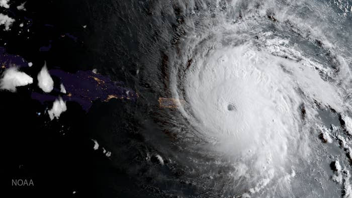
On a rampage across the Caribbean, Hurricane Irma is aimed right at Florida and South Carolina, according to Wednesday evening's forecast, now packing 185 mph winds and promising storm surges 10 to 20 feet high along the coast.
Now the most powerful Atlantic Ocean hurricane on record, Irma is a Category 5 storm some 500 miles wide, with hurricane-force winds extending 50 miles from its eye.
On Wednesday, the US National Oceanic and Atmospheric Administration (NOAA) updated its forecast track for Irma to place its center almost exactly on Miami, making landfall on Sunday morning.
By late Wednesday, the storm pounded several Caribbean islands with a 9-foot storm surge, and threatened Puerto Rico after passing over the Virgin Islands.
“Irma’s a big, big storm. There’s no way to get around it,” meteorologist Jeff Weber of the National Center for Atmospheric Research (NCAR) told BuzzFeed News. “It’s a very dangerous storm.”
Unlike Hurricane Harvey, which stalled over Texas last week, delivering an unprecedented 51 inches of rain on the Houston region, Irma promises a different disaster — a storm surge of 10 to 20 feet of water, and wind speeds of severe tornado strength that would cut a 100-mile swath where it makes landfall. Irma is also expected to proceed north at about 15 mph after landfall.
The worst-case scenario is that the hurricane continues on its beeline for Miami with its high winds intact, then returns to sea to strengthen and then smack into Georgia and South Carolina, as the NOAA track forecasts. Key West authorities have called for evacuations, and schools in south Florida are closing on Thursday and Friday.
A week after Hurricane Harvey, “we now have two worst-case scenarios,” Paul Walsh, director of weather strategy at IBM Global Business Services, told BuzzFeed News. “We spent all last week calling Harvey ‘unprecedented’. Now it’s ‘unprecedented’ times two.”
Building codes in Miami-Dade County, home to 2.7 million people, are designed for winds of up to 185 mph at most, the most stringent in the Sunshine State. At those wind speeds, a 2006 analysis found roof shingles were more than 80% likely to be ripped off if they were nailed on, and even roofs with hurricane clips holding down shingles were 25% likely to fail. Debris from homes and shattered windows is a big worry in such storms.
The closest analogue to Hurricane Irma striking Miami is 1992’s Hurricane Andrew, which caused $50 billion in damages and destroyed or damaged 125,000 homes. A recent Swiss Re analysis concluded that if Andrew hit Miami today, it would cause as much as $300 billion in damages.
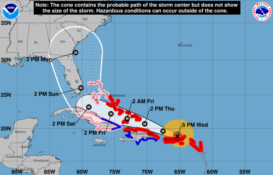
The storm forecast tracks have drifted east and then west in recent days, indicating a possible scenario where Irma could brush by Florida, steering into the South Carolina coast. A best case would be the storm’s track shifting east even more, taking the storm out to sea in the Atlantic Ocean. Hurricane Matthew, a Category 5 storm, did something like that last year, brushing along the Carolina coast and causing inland flooding there before heading back out to sea.
Hurricane “Category” on the Saffir-Simpson Hurricane Wind Scale, where a Category 5 storm has wind speeds greater than 157 mph, really doesn’t do Hurricane Irma justice, shoreline geoscientist Robert Young of Western Carolina University told BuzzFeed News. A storm’s category essentially has no relation to the surge it might produce, flooding the coasts, Young’s research has shown. So, if Hurricane Irma loses its Category 5 status, it would still be dangerous.
2012’s Hurricane Sandy wasn’t even a hurricane anymore, for example, with wind speeds of 80 mph at landfall, when it swamped New Jersey’s coastline and flooded New York’s subway with a 9-foot storm surge on top of 5 feet of tide.
Irma has topped the Cyclone Damage Potential (CDP) index, an alternative measure of the destructive capacity of a hurricane, because of its combination of size and strength, NCAR’s James Done told BuzzFeed News.
“The environment along Irma's projected path is highly supportive of an intense hurricane,” Done said by email. “Whereas the Saffir-Simpson scale will stay about flat I expect the CDP to increase as the area of strong winds expands with age of the storm.”
A storm’s diameter is at least as important for its destructive power, “if not more important” than wind speed, Young said. Sandy was 1,100 miles across when it delivered its blow, for example, pushing forward a long wall of water that devastated the entire New Jersey coastline.
“Irma is a reasonably fat storm, compared to Harvey,” Young said, threatening hurricane force winds across the east half of Florida even if it misses landfall. But the curved path it will follow after exiting the Caribbean to head north should reduce some of the storm surge of water in its path, keeping it under 10 feet along Florida’s southeastern coast, Young estimates.
The Sunshine State also has a curved coast that should allow water to escape from in front of the storm, instead of concentrating it in an enclosed basin like the coast of Florida’s panhandle in the Gulf of Mexico. Hurricane Andrew, a Category 4 storm at landfall 20 miles south of Miami, only had an 8-foot storm surge. On the other hand, Florida’s Apalachee Bay and South Carolina’s North Myrtle Beach — two coastal locales potentially in Irma’s path — are unfortunately convex-shaped and might instead concentrate a storm surge higher. The uncertainty about the storm’s path leaves plenty of unfortunate possibilities.

If someone is telling you they know where #Irma will make landfall, they're wrong. Florida through the Carolinas ar… https://t.co/gDNhCxTMIZ
“Welcome to the wonderful world of hurricane forecasting,” said Walsh, who advises businesses on types of good to stockpile ahead of a disaster — comfort foods with a long shelf life are a good bet. Businesses across the southeast are stockpiling goods like bottled water at distribution centers, he said, knowing a hurricane is likely to hit somewhere in the region.
“The only positive side of Harvey hitting last week is that people are pretty motivated to prepare now,” he added. “We are seeing stores in Florida move a lot of emergency-type supplies days earlier than normal. That’s a good thing with this storm coming.”