Review

Sustainable Management, Conservation, and Restoration of the Amazon River Delta and Amazon-Influenced Guianas Coast: A Review

by
Edward J. Anthony
1,*,
Eduardo S. Brondizio
2,3,
Valdenira F. dos Santos
4,
Antoine Gardel
5 and
Manon Besset
6
1
CEREGE, Aix-Marseille University, 13545 Aix-en-Provence, France
2
Department of Anthropology, Indiana University, 701 E Kirkwood Ave, Bloomington, IN 47405, USA
3
Center for the Analysis of Social Ecological Landscapes, Indiana University, 701 E Kirkwood Ave, Bloomington, IN 47405, USA
4
NuPAq, IEPA, Macapá 68903-372, Brazil
5
USR LEEISA, CNRS, Ifremer, Université de Guyane, 97334 Cayenne, France
6
i-Sea, Bordeaux Technowest, 25 Rue Marcel Issartier, 33700 Mérignac, France
*
Author to whom correspondence should be addressed.
Water 2021, 13(10), 1371; https://doi.org/10.3390/w13101371
Submission received: 30 March 2021 / Revised: 3 May 2021 / Accepted: 8 May 2021 / Published: 14 May 2021

Abstract

:
The Amazon River delta may be currently characterized biophysically as a relatively preserved delta compared to the rampant vulnerability of many of the world’s large deltas. This status of relative preservation is reflected in a number of criteria: The still largely free-flowing nature of many of the rivers and the main stem of the Amazon that feed the delta in sediment, exceptional biodiversity, dominant shoreline accretion, and the absence of anthropogenically-generated subsidence. In this review, we show that these relatively reassuring conditions are progressively being called into question by the effects of dams on fluvial sediment supply to the delta, by increasing demographic, urban, and land development pressures in this still largely underpopulated delta, and by problems of governance that underplay aspects of basin-wide and deltaic environmental deterioration. A major challenge is that of bringing together these contrasting demands that are leading to the emergence of zones of environmental stress that test the resilience of this delta. An integral part of the strategy for the analysis of collective action, management, and conservation is that of considering the Amazon delta in terms of interacting socio-ecological systems. Pressures on the delta will be compounded in the future by decreasing fluvial sediment supply and sea-level rise. Although climate change is projected to generate surplus sediment, the rapid growth of dam constructions upstream of the delta will negatively impact the river’s sediment flux. Conservation and management of the Amazon River system aimed at keeping the delta resilient in the context of sea-level rise and reduction of sediment supply will require clear governance and better planning and anticipation, as well as socio-ecological integration. These are also requirements that will need to be implemented in the 1500 km-long coastal zone of the Guianas countries located west of the Amazon delta and the sediment dynamics and stability of which are largely determined by sediment supply from the Amazon.

1. Introduction

Much of the early research on modern deltas focused on their oil- and gas-bearing potential, inspired by an extensive corpus of work on the Mississippi delta, and how it is an analogue for ancient deltas in the rock record. There has been a shift, however, towards increasingly more diverse, and cross-disciplinary research on deltas under the increasing pressures of population growth in coastal areas, human modifications of river basins, and the effects of climate change, notably on sea-level rise and storm intensities [1]. At the nexus of watersheds, land, coastal areas, oceans, and human settlements, river deltas pose specific challenges to environmental governance and sustainability because of the high degree of functional interdependencies shaping their social-ecological dynamics [2], and that eventually underlie management and conservation strategies. Deltas are characterized by low topography and are thus particularly vulnerable to catastrophic river floods, tsunami, cyclones, subsidence, and global sea-level rise. This vulnerability is increasing as a result of reduced sediment flux from rivers and various other modifications caused by human interventions [3,4,5]. Although deltas may develop resilience and adapt to changes in sediment supply and sea level, commonly by re-organizing their channels and their patterns of sedimentation, human impacts coupled with the effects of climate change are rendering many deltas economic and environmental hotspots. If river deltas are complex, the Amazon is arguably the most complex of all, given the exceptional continental scale, biophysical diversity, and global significance. The management and conservation of the region’s delta system is a task beset with complexity and uncertainties.
The Amazon delta (Figure 1) is unique in several ways: The inordinate size of the catchment to which it is connected and the massive sediment supply have led to the formation of the world’s largest delta with significant hydrological, sedimentological, morphological, and ecological diversity. The sheer size of the delta has implied widely varying area estimates: 465,000 km2 [6], 467,100 km2 [7], 160,662 km2 [2], and 85,667 km2 [8]. In [2], the authors defined the delta area based on the intersection of biophysical and political-administrative boundaries, and suggested that the larger estimates may be due to the full inclusion of tidal channels and flats not directly connected to the main river and channel network. The influence of Amazon-derived sediments is felt along a coastal belt stretching for 1500 km from the mouths of the river to those of the Orinoco (Figure 1). At a time when more deltas are becoming vulnerable and less resilient, the Amazon River delta remains biophysically resilient, whether on the basis of accelerated human-induced subsidence [9] or in terms of gains or losses in the area of the shoreline [10], although its population is growing rapidly (Table 1).
Notwithstanding this current status, the Amazon delta is faced with significant human and environmental challenges that may progressively erode away the firm status of a non-vulnerable delta in which it is presently set. This paper is a review of some of the management and conservation issues facing the Amazon River delta and the Amazon-influenced Guianas coast of South America. The review is based on a cross-disciplinary evaluation of research on both the delta and its fluvial hinterland. It will focus on a number of key themes, and insist on the intricate relationship between management and conservation aspects, notably considered in the framework of socio-ecological systems, and overarching governance issues. Whether a credible agenda of integrated management and conservation can be implemented to mitigate future vulnerability and maintain resilience of the Amazon delta in the face of sea-level rise and these rising challenges remains to be seen. Following this (1) introduction, we develop the following themes: (2) The Amazon delta and its river basin; (3) delta hydrology, morphology, and sedimentation; (4) gauging pressures that are building up on the delta, as well as on river-delta connectivity and the expected effects of climate change viewed in terms of sediment supply and sea-level rise; (5) a management and conservation framework for the Amazon based on socio-ecological systems; (6) the alongshore extension of the Amazon’s influence on the Guianas coast; and finally, (7) the conclusions. The review of the study is complemented by mapping aspects of deltaic landforms, shoreline geomorphic changes, and delta-wide socio-ecological relationships, the methodological aspects of which are briefly presented in the relevant sections

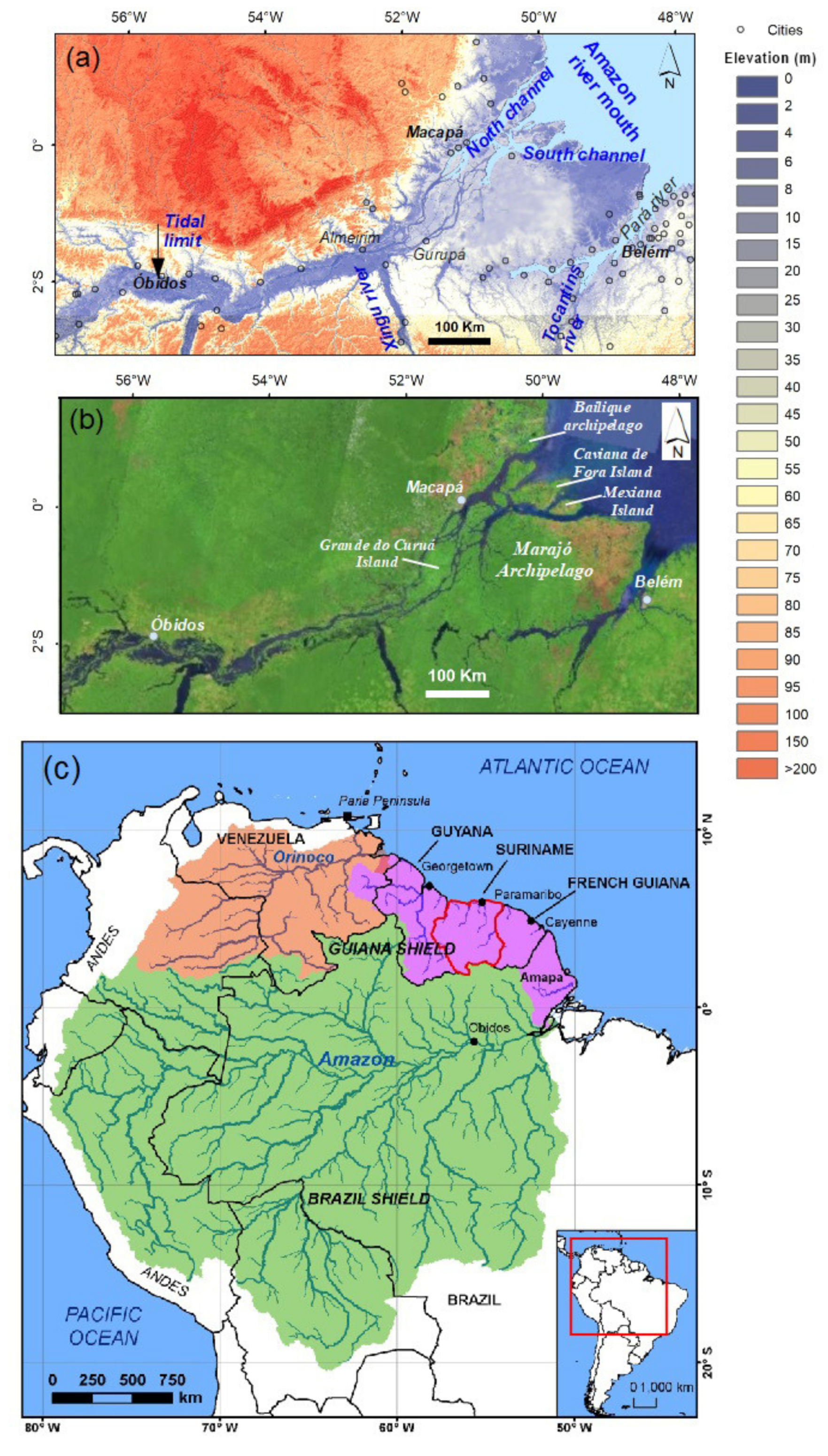
2. The Amazon Delta and the River Basin

The Amazon delta is connected to a drainage basin (Figure 1) with an area of 6.1 × 10⁶ km2 [13], by far the largest on Earth. The basin is flanked to the west by the Andes Mountains, which are part of an active tectonic margin, encased between the Central Brazil and Guiana Shields, and its delta has formed on a passive continental margin. An estimate of the mean annual water discharge of the river at the village of Óbidos, 800 km upstream of the mouth (Figure 1) has been set at 173,000 m3 s−1 [14]. The Amazon also discharges the highest total sediment load to the global oceans. The estimated sediment load delivered to the Amazon basin by weathering and erosion of the Andes Mountains is 2300–3100 Mt/y [15], but complex sediment storage and release pulses in floodplains upstream of the delta and within the delta plain itself result in a sediment discharge at Óbidos, ranging from only 754 to 1000 × 106 t a1 [14,16]. Overall, as a result of the size of the Amazon basin, the specific sediment yield of 190 t km2 a−1 corresponds to the world’s average [17]. About 90% of the sediment load is silt and clay [18], reflecting intense tropical weathering of the dominantly Andean magmatic rocks [19,20], and smectite (35%), illite (25%), and kaolinite (31%) have been identified in surface deposits at the mouth of the Amazon. Amazon sediment mineralogy changes with distance along its course. The mud fraction derived from the Andes is initially dominated by the first two clay minerals but becomes progressively enriched in kaolinite as a result of downstream chemical weathering under the tropical climate regime [21,22]. Bedload estimates at the delta are rather sketchy but much lower than the mud fraction, as one would expect with large river catchments. The authors of [23] computed a bedload of about 4.7 × 10⁶ t a−1 based on bedform structures, which is a very small fraction of the total load. Near the main source areas at the foot of the Andes, the sand fraction contains heavy minerals and lithic fragments [24], but becomes progressively richer in quartz due to weathering of the fragile magmatic rock minerals and to contributions of quartz-rich sediments from tributaries of the lower basin draining basement shield rocks [21,22]. Amazon sediment is mostly supplied by the Madeira and Solimões tributaries, the suspended load of which is >100 mg/L [25,26], with a negligible contribution of <10 mg/L by the Rio Negro [26]. The works of [14], [27,28] have shown that the liquid discharge is relatively regular whereas sediment discharge showed more significant inter-annual and decadal variability.
The Amazon basin encompasses the single largest remaining tropical rainforest in the world, houses at least 10% of the world’s known biodiversity, including endemic and endangered flora and fauna, and contains the largest number of freshwater fish species in the world (https://wwf.panda.org/discover/knowledge_hub/where_we_work/amazon/about_the_amazon/? (accessed on 20 March 2021)). As [29] noted in their excellent synthesis on Amazon sediment transport across the fluvial to coastal continuum, the large scale of the Amazon River provides other valuable reasons to investigate its coastal interface: Amazon discharge impacts the global ocean, especially the Atlantic and its freshwater discharge is nearly a fifth of the world’s total river discharge. Its solute release, 260–290 Mt/y, i.e., 260–290 °ø 106 t/y [30,31], is the dominant point source for many chemical components entering the global ocean. The importance of the Amazon river plume for ocean CO2 sequestration has been emphasized by [32]. The Amazon supplies most of the sediment migrating along, and deposited on the 1500-km long coast of the Guianas to the Orinoco River delta in Venezuela (Figure 1c) during the present high stand of sea level [33].

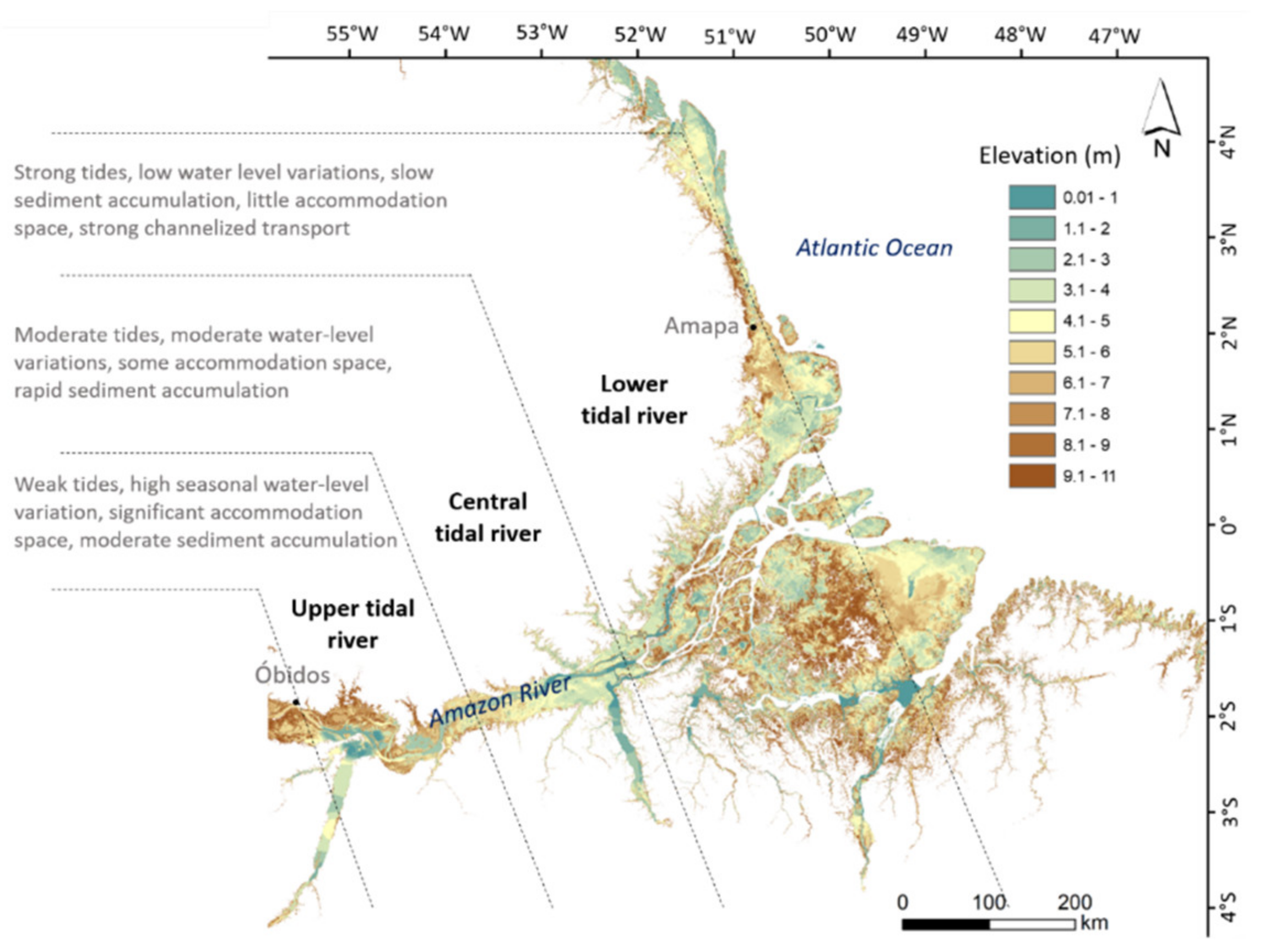
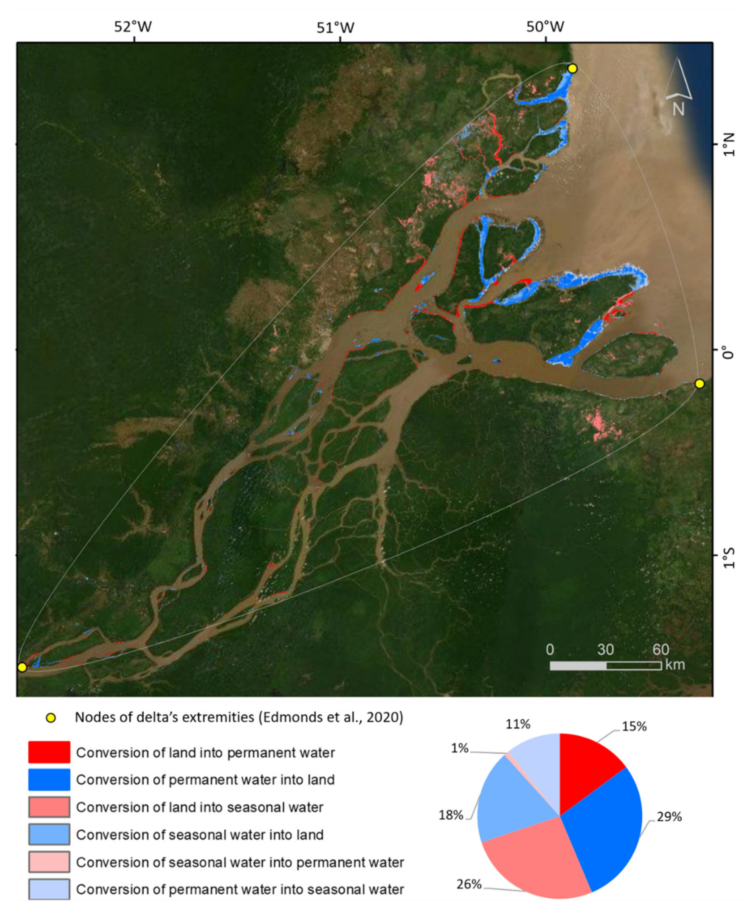
3. Delta Hydrology, Sedimentation, and Geomorphology

The Amazon delta coast composes 14% of Brazil’s coastline [34], and comprises three of the country’s 26 states (Amapá, Maranhão, and Pará). The sheer size of this delta implies that collecting spatial (and temporal) data on its hydrology, sedimentology, geomorphology, and landforms is a Herculean task that is best tackled by Earth-observation techniques (e.g., [34,35], complemented by field monitoring stations). The climate of the delta is equatorial humid and strongly influenced by the Intertropical Convergence Zone, the migration of which generates seasonal rainfall of up to 4000 mm between December and May and a dry season from June to November, with up to 350 mm of rainfall [36,37]. ITCZ variability is also controlled by ENSO conditions with repercussions on rainfall [38].
Figure 2 is a MERIT digital elevation model [39] of the large delta plain and its narrower river floodplain extension. The figure also shows a continuum of changing water levels from Óbidos to the northern part of the river mouth and aspects of sedimentation in this continuum identified by [40]. The delta is characterized by elevations that are largely within the delta’s tidal range variation with marked spatial variability generated by the juxtaposition of channels, levees, flood basins, and lakes, and discontinuous sand barriers and cheniers, but there are areas up to 11 m high. The delta experiences semi-diurnal tides and the spring tidal range at the mouth varies from 5 to 8 m, diminishing gradually upstream, but connecting and rendering uniform vertical references is still a challenge. Tidal influence on river flow is felt as far upstream as the village of Óbidos [41]. Overprinted on these variations is a marked seasonal trend with the highest water levels in May–June and the lowest in October–November [29]. High flood levels and prolonged inundation of the Amazon River occur during La Niña events (cold ENSO-phases), and lower flood levels and shorter inundation durations during El Niño events (warm ENSO-phases).
Sediment flux is an important preliminary component of management and conservation of coastal and deltaic systems because sediments form the foundations for delta growth, mitigate natural subsidence, and enable delta sustenance in the face of sea-level rise. Although the Amazon appears to be a still relatively preserved deltaic system, compared to the Mississippi, pressures are rising as the population within the delta itself increases, large-scale agriculture and cattle rearing become more widespread, and more dams built upstream trap sediment [2], [42,43]. Clearly, a fine analysis of sediment cascades and traps is an essential first consideration in such a large system as that of the Amazon, where buffers can be operational throughout the river main stem and tributaries [29].
The floodplain on both sides of the main channel is the feature with the greatest surface area linked to the Amazon tidal river [29], which shows decreasing downstream seasonal river-level fluctuations from 8–10 m at Óbidos to negligible at the river mouth [44]. These fluctuations are important in controlling overbank deposition in the floodplain and tidal river and in overall sedimentation in the delta [40,45]. The tidal river corresponding to the deltaic reach has been divided by [40] into three sectors, each defined in terms of available sediment accommodation space, with transitions along a continuum from Óbidos to the river mouth (Figure 2).
The upper tidal river is fluvial-dominated and quite similar in terms of river-floodplain hydrology and sediment exchanges with the non-tidal reach above Obidos. It is characterized by a small tidal range (tens of centimeters). Around seasonal high level [41], when the elevation of the river exceeds crevasse and levee heights, its water communicates with the floodplain. The tidal range increases to 1–2 m in the central tidal river [41] and sediment accumulation rates commonly exceed 1 cm/year on the floodplain [29]. The lower tidal river is dominated by floodplains where turbid tidal flows move through dendritic networks of channels, presently exchanging about 2% of the Amazon sediment load with the floodplain [46] and building vegetated tidal flats composed of fine silt and clay (5–20 μm, <30% sand, [45]). The Amazon delta accounts for 75% of Brazil’s mangroves [47]. Mangroves cover 38,304 km2 of the delta [48], i.e., about 28% of the world’s mangroves inventoried by [49]. The tidal flats reach a level limited by high water during spring tides and seasonal high-river flow [46]. Consequently, although local processes have the potential for rapid sedimentation, accumulation rates are dependent on sea-level rise and are approximately 0.3 cm/y [45]. The work of [29] has shown that the upper tidal river lacks effective processes for supplying enough sediment to fill the floodplain lakes whereas the lower-tidal-river floodplain has already been filled and only has space to accommodate new sediment as sea level rises. As a result, the segment of the tidal river most effectively trapping sediment at present is the central tidal river. Previous estimates showing that the total amount of sediment accumulation in the Amazon tidal river is approximately 300–400 Mt/year [29] drew the important conclusion that unique processes operating in floodplains and in tributary mouths along the tidal river create sinks between Óbidos and the mouths of the river. These sinks significantly reduce the amount of sediment reaching the ocean. Much of the coastal floodplain is submerged by high water in the rainy season [50]. A corollary of this situation is that parts of the subaerial delta, notably the smaller channels and some of the islands at the mouth of the north channel, are undergoing relatively rapid accretion according to Global Surface Water Explorer data [51], with high ratios of conversion of water to land, and smaller inverse ratios (Figure 3). The work of [52] reported a marked increase in very severe floods and increased flooding from an analysis of records (1968–2015) at Óbidos linked to a strengthening of the Walker circulation resulting from strong tropical Atlantic warming and tropical Pacific cooling. Given the intricate links between the three tidal reaches and sediment accommodation space in the continuum from Óbidos to the river mouth (Figure 2), these severe flooding events must be influencing sediment supply, probably generating enhanced deposition. However, there is a need for a better understanding of boundary conditions affecting Amazon sediment dispersal [29].
Unlike many of the world’s deltas, the Amazon has not built up a classic river delta protruding from the present regional coastline (Figure 2). This may be attributed to the large water discharge and predominantly fine-grained sediment supply of the Amazon [53], much of the sediment being trapped on the shelf to the benefit of a subaqueous delta [54]. These conditions are further favored by the extremely energetic conditions at the mouth that are assured by the river’s massive freshwater discharge, energetic tidal currents in a macrotidal environment, trade winds from the northeast that also generate moderately energetic surface gravity waves, swell waves from the North Atlantic, and an ocean-boundary current. The combination of a large liquid discharge and the predominantly fine-grained sediment supply of the Amazon have contributed to inhibiting subaerial delta protrusion, much of the sediment exiting from the mouth being trapped on the inner shelf to the benefit of the subaqueous delta [54], while some drifts along the mud-bank belt towards the coasts of the Guianas [53].
The mouths of the Amazon may be defined as river-tide-wave dominated, reflecting the full range of energetic processes associated with the high river discharge, large tides, and ocean waves [53]. Flow reversals can extend upstream for more than 300 km from the Atlantic Ocean [41] and, during spring tides in some locations, can cause a tidal bore known as the pororoca [55]. In the river channel, the combination of fluvial and tidal flows creates high water velocities (>200 cm/s) and strong bottom shear stresses [56] resulting in the prevalence of coarse sediment in the channel beds that is reworked into giant sand waves that can reach 10 m in height [21,22]. Sedimentary structures reveal cross-bedded sands in the channel bottoms and interbedded sands and muds on channel flanks, transitioning to overbank into the muddy freshwater tidal flats [21].
The largest of the islands at the mouth sensu lato of the Amazon is Marajó, the east side of which is related to the evolution of Tocantins River [57]. In total, 95% of Amazon’s water and sediment are presently transported seaward through the north and south channels (Figure 1a), with about 5% diverted through a network of tidal creeks (known locally as furos) on the southern side of the Marajó archipelago [58]. In these creeks, the net flow is indicated by sand waves (4–5 m high) with an asymmetry documenting southward transport [21]. The large distributary mouth south of Grande do Gurupá island delineates the southeastern boundary of the Amazon river mouth [21,22].
The Amazon delta is rimmed by a highly diversified muddy, sandy shoreline that is 800 km long on either side of Marajo Island [59]. A number of hydrological and ocean-atmosphere interactions converge to generate a drifting of a fraction of Amazon mud towards the coasts of the Guianas within the world’s largest mud-bank belt [53]: The strong river water discharge exiting essentially through the north and south channels north of the Marajo archipelago (Figure 1), the overall directional forcing at the mouths of the river by the dominant trade winds from the northeast and the gravity waves and ocean-boundary current these winds generate, and a decreasing tidal range towards the northwest. This results in a striking difference in shoreline facies between a muddy western belt that stretches to the Orinoco delta and a sandier, relatively mud-deficient, sector east of the mouths of the Amazon. The bulk of the Amazon fine-grained sediment transiting alongshore is, thus, transported northwestwards along the Amapá coast and has contributed to the formation of a muddy coastal plain that extends along the Guianas coast (see Section 6). Much of the muddy shoreline in this sector of large tidal range (up to 8 m at spring tides) is presently erosional with localized sandy deposits that form cheniers in places. A smaller amount of mud is advected southeastward along the Pará coast southeast of Marajo Island. This part of the delta coast is sandier, macrotidal (>4 m at spring tides), and exhibits a series of discontinuous wave-built barriers [60] separated by tide-dominated estuarine embayments characterized by mudflats and mangroves [61,62,63,64].
The Amazon delta is thus associated with a variety of river, tidal, and coastal landforms characterized by marked spatial and seasonal variability in topography and bathymetry that also change at rapid rates. This variability imparts a high degree of biodiversity, but also implies seasonal constraints associated with flooding. The size of the delta and this variability also have implications for accurate and updatable mapping of the intricate elevation and bathymetry that condition the emplacement and extent of human settlements, land and water use in the delta, and socio-ecological gradients.

4. Gauging Pressures That Are Building Up on the Amazon Delta

Pressures on river deltas may be synthesized in terms of five criteria: (1) Water and sediment supply from the river basin; (2) natural hazards; (3) direct pressures from land-use and urbanization; (4) the effects of climate change and sea-level rise; and (5) the effects of governance and policy, which are discussed in Section 5.2.

4.1. Pressures on the Amazon River Basin That Are Filtering Down to the Delta

River basin changes are essentially associated with land-use changes and basin management and engineering, both of which can directly be translated in terms of pressures on deltas through the impacts they have on water and sediment supply. These changes can engender vulnerability of the biophysical and socio-ecological functions of deltas, and impair resilience in the face of natural and anthropogenic pressures.
As noted by [29], appreciable impacts of human activities in the Amazon are fairly recent, dating back only five decades, and not centuries or millennia ago, as with other large river systems (such as the Nile, Indus, Mississippi, and Yangtze). However, development pressures in Brazil are leading to a rapid exacerbation of the effects of these activities, with indirect and direct impacts on the Amazon delta.
From the early 1990s to the early 2010s, particularly following the Rio-92 United Nations (UN) Conferences on Sustainable Development, Brazil emerged as an environmental leader with a prominent international role. Brazil earned praises for implementing a bundle of socio-environmental policies, including the expansion of its network of protected (PA) and Indigenous areas [65]. The Action Plan for the Prevention and Control of Deforestation in the Legal Amazon (PPCDAm), launched in 2004, promoted sweeping reforms in environmental governance and monitoring, which led to a reduction of 80% in deforestation by 2012 [66]. This tendency was further boosted by economic factors that led to a slow-down in deforestation, such as commodity prices and currency exchange rates that affected the profitability of agricultural exports [67]. This period of goodwill saw the expansion of Brazil’s PA system to nearly 2.2 Mkm2 or 12.4% of the global total (DPPA). Among these were 0.498 Mkm2 of undesignated public forests (UPF) not allocated by the federal or state governments to a specific tenure status [68]. PAs are aimed at safeguarding species-rich biomes on Earth and important ecosystem services. However, between 2008 and 2014, Brazil lost 12,400 km2 of these PAs due to degazetting and 31,700 km2 due to downsizing [65]. Since 2012, deforestation has trended upward despite control efforts, such as improved satellite—based monitoring, “blacklisted” municipalities, expansion of protected areas, land tenure regularization, credit access restrictions, moratoria, but also a variety of other activities [67]. Deforestation has increased particularly since 2018, coinciding with the dismantling of legal instruments and environmental governance infrastructure more broadly [69]. Like Indigenous areas [70], UPFs have been vulnerable to land grabbers and land speculation, and have been particularly prone to illegal deforestation 0.26 Mkm2 by 2018, resulting in an emission of 1.2 billion tons of CO2 [68].
The effects of pressures of deforestation under unplanned agricultural expansion, accelerated by fires, have no doubt increased the potential for soil erosion that enhances fluvial sediment loads, but counter pressures on the availability of sediment loads to the Amazon delta are being exerted as a result of hydropower development and exploitation of mineral resources. Mining grew from 1.6% of gross domestic product in 2000 to 4.1% in 2011 with production expected to further increase by a factor of 3 to 5 by 2030, while much of the country’s hydropower potential remains untapped [71]. Few dams existed in the basin but more than a hundred hydropower dams have already been built there and there are numerous plans and project proposals for further constructions [71,72]. Dams have triggered a 20% drop in the suspended load of the Madeira River tributary [71]. Thus far, it is not clear to which extent the sediment discharge in transit downstream to the delta is being negatively impacted, probably because the effects of the still limited number of dams are balanced by rapid deforestation and sediment release through soil erosion. These variations could explain the fluctuations in sediment load at Óbidos noted by [28]. Anecdotal reports from communities along the river have pointed to accelerated sedimentation, especially in tidal creeks, over the last two decades but there are no real data to corroborate this. Presumably, the large floodplains of the Amazon and the immense delta can absorb these fluctuations through modulation of rates of sedimentation, which are currently relatively high, as outlined above.

4.2. Natural Hazards in the Amazon Delta

The Amazon delta cannot be considered as being particularly exposed to natural hazards, but a large share of its population lives under a high-degree of vulnerability to flooding [73,74]. This situation reflects both an equatorial setting that puts the delta off the trajectory of tropical storms and cyclones, and a mild (but probably not negligible) tectonic context. The authors of [75] have documented an 1885 earthquake that attained a strong reported intensity of up to VI–VII in the modified Mercalli intensity (MMI) felt in French Guiana, and that caused slight damage. According to the authors, recently discovered newspaper records show that this event was also felt as far as Georgetown (British Guyana), and in the Amazon basin and delta up to Manaus. The distribution of intensities and the radius of the felt area indicate a magnitude around Mw 6.9, which makes it the largest known earthquake in the stable continental region of South America since the 19th century. Seismic hazards must therefore not be neglected in the low-lying Amazon delta, especially with regards to potential tsunami generation. The recognition of this large 1885 earthquake will likely necessitate future reevaluations of seismic hazards in mid-plate South America [75], including the Amazon delta, with the potential risk of a tsunami. More distant tsunami originating from the Canary Islands and propagating westwards in the Atlantic Ocean [76] could also attain the Amazon delta and could be potentially subject to amplification over the low inner shelf.
The work of [73] has stressed the need for integrated multi-hazard approaches based on a social-ecological systems perspective, a theme further developed in Section 5.2. The importance of this perspective in the functional dynamics of deltas has been demonstrated by [2,74] with particular reference to the Amazon delta. Using a social-ecological systems perspective, the work of [73] applied a library-based approach to the assessment of multi-hazard risks to which are exposed social-ecological systems across and within coastal deltas globally, and applied it to the Amazon, Ganges-Brahmaputra-Meghna (GBM), and Mekong deltas. Their results, not unexpectedly, show that multi-hazard risk is highest in the populous GBM delta (0.21 in a range from 0 to 1) and lowest in the low-population Amazon delta (0.09 in a range from 0 to 1), where primarily the southeastern municipalities are affected by both flooding and droughts [77]. The equatorial setting ensures low variability in precipitation in much of the humid Amazon delta. The analysis conducted by [73] revealed major differences between social and environmental vulnerability across the three deltas, but notably more so in the cyclone-exposed Mekong and the GBM deltas where environmental vulnerability is significantly higher than social vulnerability.

4.3. Increasing Pressures of Land-Water Use Changes and Urbanization within the Delta

The authors of [78] have shown, among other studies, that a considerable segment of the population living in the tidal part of the delta region is directly dependent on intensively managed agroforestry systems and different types of extractive activities of natural resources for their livelihood [79,80]. However, recent and increasing pressure on ecosystem services in the Amazon delta is considerably exacerbated by a combination of factors related to the environment, climate, economy, and socio-demography. The work of [78] used a combination of remote sensing data, ecosystem service literature, and official Brazilian government statistics to produce spatially-explicit relationships linking the green vegetation cover to the availability of ecosystems provided by forests in the delta region. Their results show that continuous changes in land use/cover and in the economic context contributed significantly to changes in key ecosystem services such as carbon sequestration, climate regulation, and the availability of timber over the last 30 years. Agricultural expansion, urbanization, selective logging, forest fires, and inundation of large areas for river dam construction have been leading to municipalities and regions continuously losing forest [78], echoing the trend throughout the Amazon River basin. These changes include tree plantations that are massively expanding in the delta state of Amapá, where both the savanna-scrub vegetation and swamp forests are being rapidly destroyed by plantation development, notably devoted to soya. In total, 66% of the cattle (water buffaloes) herds of Brazil are found in the Amazon tide-influenced delta plain [81], a substantial rise relative to the herds reported by [82]. These herds are deemed responsible for soil degradation, channel erosion, and enhanced turbidity [55]. The work of [2] showed that although the Amazon delta is considered among the most preserved and resilient, its long-term sustainability is increasingly impacted by urban growth, infrastructure development, increasing demand for the large range of resources, industrial, plastic, and urban sewage pollution because of the lack of basic sanitation and sewage and recycling facilities, and large-scale agriculture in floodplain zones [83]. These factors are generating pressures on local ecosystems and livelihoods.
Inroads into the mangroves of the Amazon delta and the numerous socio-ecological services they represent are still to be clearly determined. Deforestation related to urbanization and other activities such as shrimp farming is probably balanced by the creation of new land resulting from active deltaic sedimentation (Figure 3). The work of [84] evaluated the role of marine aquaculture along the Amazon delta coast using remote sensing and geographic information system techniques and showed that these farms by then (2015) covered an area of ~0.8 km2 (approximately 0.4% of Brazilian ponds), of which 29.4% are located within areas of mangroves, associated with the conversion of 0.53 km2 of the mangroves into rearing ponds, which represents only 0.007% of the total area of Amazon mangroves.

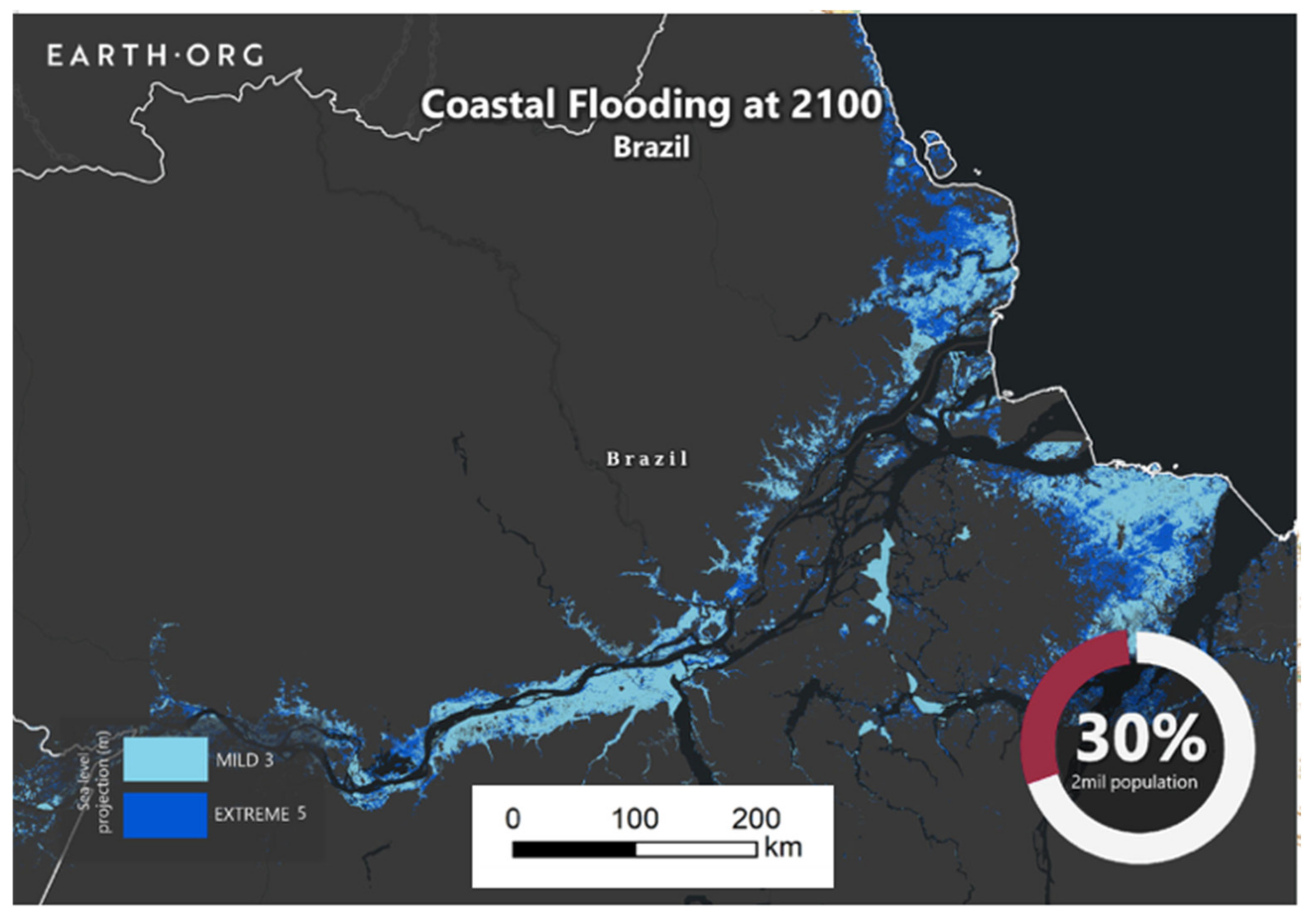
4.4. Climate Change and Sea-Level Rise

The pressures evoked in the preceding section can only be aggravated by sea-level rise and climate change. This may occur notably through a decreasing sediment supply that could lag behind marine accommodation space created by sea-level rise. In their analysis of projected changes in fluvial sediment flux received by 47 major deltas over the 21st century based on 12 scenarios constructed using four climate pathways (Representative Concentration Pathways 2.6, 4.5, 6.0, and 8.5), three socioeconomic pathways (Shared Socioeconomic Pathways 1, 2, and 3), and one reservoir construction timeline, the authors of [85] projected that the Amazon delta will receive a fluvial sediment load that will decline by 23% by 2070–2099 relative to 1990–2019 values. The authors projected that this decline will be caused by land use changes and dam construction, notwithstanding a +4 to +7% increase in sediment discharge resulting from the effects of future climate change. Although the Amazon, like 39 of the 47 deltas analyzed by [85], will undergo an increase in sediment flux across all four of the climate change pathways, with projected increases in temperature and precipitation over the 21st century being the primary factor for the climate-driven increases in sediment delivery globally, sediment sequestration by dam construction projects will significantly overwhelm this increase.
The current trend of sea-level rise in Brazil is rather poorly monitored due to a dearth of tidal gauges, further compounded by long data gaps and a high level of noise in the monthly average series, mainly due to meteorological effects [86]. In the case of much of the delta, connecting the tidal gauges to the national network has been rather complicated [86], although this is an issue that the Brazilian Institute of Geography and Statistics (IBGE—Instituto Brasileiro de Geografia e Estatistica) and various Brazilian research institutions are trying to solve. In terms of Global Mean Sea Level from satellite altimetry missions, there is a trend of 3.4 mm/year (but with marked regional differences ranging between −10 and 10 mm/year), with the Amazon river mouth being among the coasts of Brazil showing the highest positive swings (data from CNES/LEGOS/CLS: https://www.aviso.altimetry.fr/en/data/products/ocean-indicators-products/mean-sea-level.html, accessed on 15 April 2021).
The expected sea-level rise in the Amazon delta (Figure 4) will increase the exposure of ecosystems, notably mangroves, and settlements to prolonged flooding in the future [8], and risks from diseases and the proliferation of mosquitoes. Sea-level rise will also affect freshwater supply by exacerbating saltwater intrusion. However, these are themes that need to be properly investigated.

5. Which Management and Conservation Framework Suits the Amazon?

5.1. A Preserved Delta? Or Are Alarm Bells Ringing?

As briefly indicated in the introduction, presently available observations indicate that the Amazon delta is not in a state of biophysical vulnerability unlike many other large deltas in the world, whether on the basis of subsidence [9], shoreline fluctuations [10], or changes in land or water area (Figure 3). This relatively preserved state is favored by a number of conditions and state of the basin that have been summarized by [29]: The enormous discharge, equatorial location, and relatively small population of the Amazon basin have significantly minimized and delayed human impacts from channel dredging, artificial levees, water diversion, and subsurface fluid extraction that have been responsible for the increasing vulnerability of many deltas, chief among which is the Mississippi [87,88]. In spite of the increasing number of dams being constructed in the Amazon basin, the impacts are still moderated by the enormous size of the basin. Eight of the ten longest free-flowing rivers in South America are located within the Amazon Basin, thus highlighting a relatively low level of river fragmentation [4]. However, if currently planned dams are built without considering the balance between energy production and environmental conservation, their potential impact in the Amazon basin will be to trigger massive cumulative negative environmental effects that will generate hydrological, geomorphic, and biotic disturbances on the river’s floodplains, its deltaic system and the sediment discharge it receives [71,72]. The work of [71] warned that the cumulative effects of these dams can be highlighted with recourse to a Dam Environmental Vulnerability Index (DEVI) that is already significant in some tributaries.

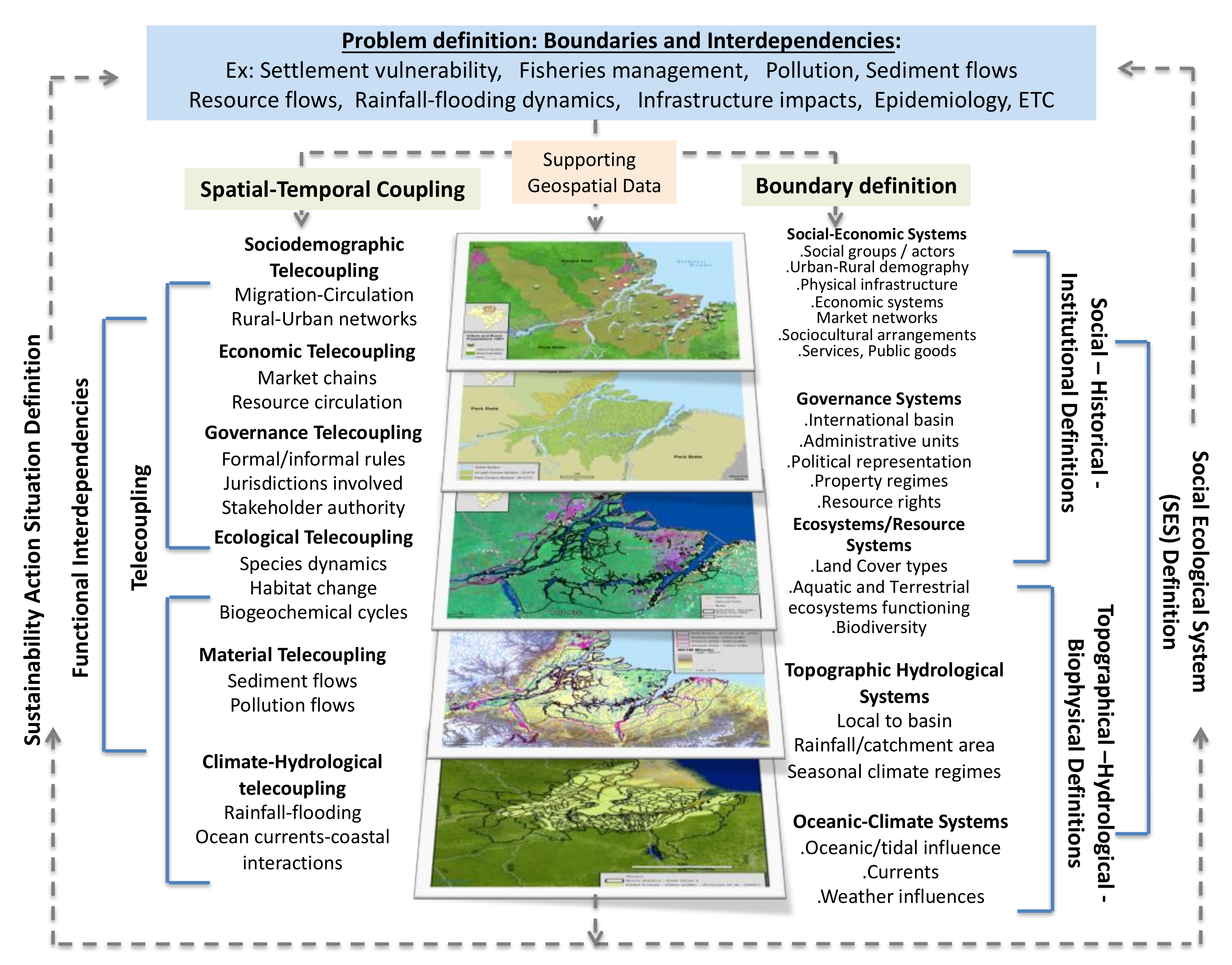
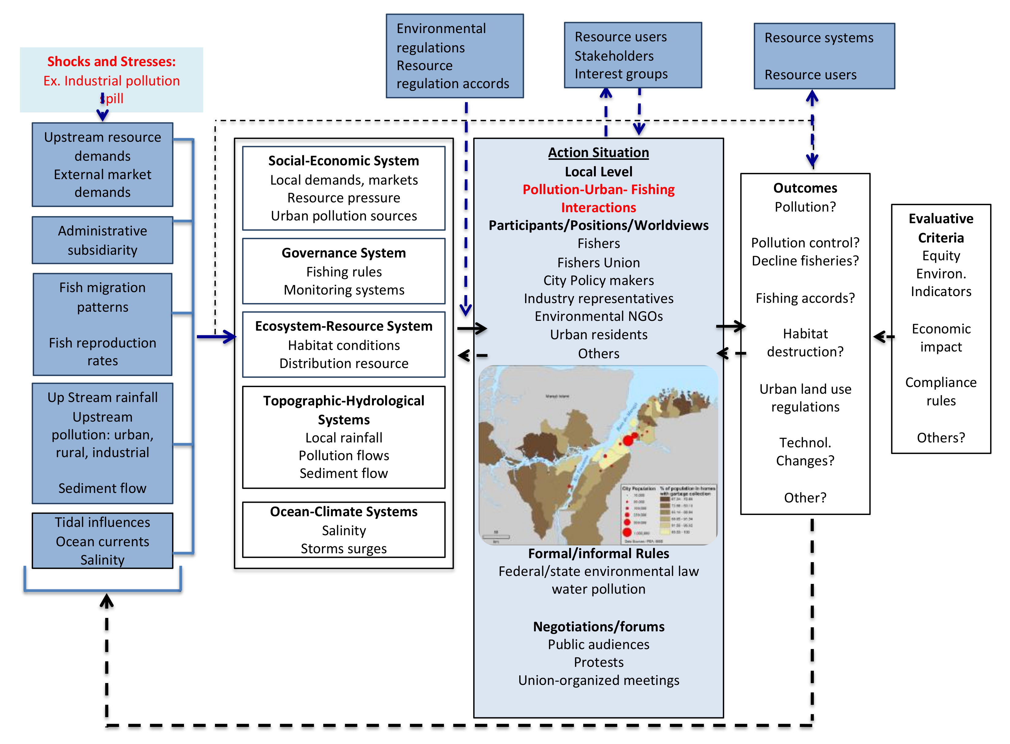
5.2. A Management and Conservation Agenda Based on Social-Ecological Dynamics and the Challenges It Poses

River deltas pose specific challenges to environmental governance and sustainability because the high degree of physical and ecological functional interdependencies shape a wide range of social-ecological dynamics (Figure 5) arising from delta locations at the nexuses of watersheds, land, coastal areas, oceans, and human settlements [2]. Ecosystems are identified as both an important element at risk as well as an entry point for risk reduction and adaptation strategies [73]. These challenges, functional interdependencies between a delta and processes happening in distant regions (e.g., sediment flow, pollution flow, fish migration patterns), and socioecological dynamics (e.g., intersection of unplanned urbanization, social inequality, and flooding patterns), are important considerations in delta management and conservation strategies. This implies considering the fine intermeshing of the socio-economic systems, governance systems, ecosystems-resource systems, topographic-hydrological systems, and oceanic-climate systems. These interacting socio-ecological systems (SES) should be an integral part of the strategy for the analysis of collective action, management, and conservation from sub-delta/local to delta to basin levels [2]. A major challenge is that of bringing together these contrasting demands. Figure 6 illustrates an example of delta functional interdependencies using the example of fisheries by coastal communities affected by pollution sources and large-scale fisheries from upstream; this is a problem particularly pertinent in an Amazon delta where communities are increasingly subject to impacts of pollution from unplanned urban growth that are having a severe effect on the ecology of the delta and on fish resources as well as on the quality of water consumed locally (Figure 6), the work of [2] shows that water quality and fisheries sustainability in one part of the region are affected by pressures created far upstream; however, discussions around the problems have not involved collaborations between fishers, city planners, and other stakeholders in different parts of the region. While fishers can develop local rules and agreements to address declining fisheries at the local level, these rules are not sufficient in dealing with distant pressures, such as changing fishing technologies, sewage and plastic pollution, industrial and mining toxic waste spills, among others. A social-ecological framework should, thus, help to characterize the complexity of the situation while considering social, physical, and ecological causal factors and impact-chains operating at different scales and time-lags, and their outcomes and consequences at different levels.
Development policies and the management of the basin as a whole, such as implying the construction of dams and deforestation, and delta management and conservation, are intertwined, embedded in overarching decision processes that shape its governance. The authors of [65] documented the erosion of Brazilian leadership, exemplary in the 1990s to 2010, in environmental matters, and it is clear that these have now attained unprecedented levels with the dismantling of environmental legislation and programs, the increase in forest fires and land degradation in 2019 and 2020 [69]. Syntheses of the world’s transboundary river basins with estimated rank indices for risks arising from legal framework, hydro-political tensions, and the capacity for water governance at a national level have shown that the Amazon basin is in the top two categories of governance risk and faces significant issues in basin management [89,90]. These insufficiencies may be expected to permeate in governance and policy on the management and conservation of the Amazon delta. These pressures will be further exacerbated by rapid demographic growth, unplanned urbanization, and infrastructure development. There is, however, some room for hope, as there are rumblings of several citizen and academic movements towards confronting these pressures. Past valiant efforts at deforestation also suggest that there could be opportunities for an alternative model that can see the Amazon re-emerge as a global reservoir of biological assets for the creation of high-value products and ecosystem services [91].

6. Alongshore Repercussions of the Amazon on the Management and Conservation of the Guianas Coast

The northwestward alongshore diversion of fluvial water and mud exiting from the mouths of the Amazon by large-scale regional wind, wave, and current forcing has generated a unique mud-dominated Holocene progradational system stretching alongshore for 1500 km, between the Amazon and the Orinoco delta in Venezuela (Figure 7), the westward limit of this muddy coastal system [33,53]. This coast is also the longest contiguous mangrove coast in the world. The economies of the Guiana countries (Figure 1)—French Guiana (a French overseas department), Suriname, Guyana, and eastern Venezuela—are all strongly influenced by the mud-belt associated with the Amazon sediment discharge. More than 90% of the populations of all three countries (French Guiana: 291,000 inhabitants in 2020; Suriname: 576,000 inhabitants in 2018; and Guyana: 780,000 inhabitants in 2018) lives in the coastal zone, distributed mainly on old beach ridges (cheniers) more or less close to the present shoreline. Population growth pressures are high in all three territories. French Guiana is currently experiencing exponential demographic growth, and a doubling of its population is expected by about 2040 (+2.72%/year). These coastal population concentrations are associated with a number of activities that are vital to the economies of the three territories. In French Guiana, this is notably the case of the ports of Cayenne and Kourou (Figure 7), the former being the main commercial port of the territory, and the latter handling materials for the satellite launching pad of the European Space Agency. In both Suriname and Guyana, the ports of commerce and industry of Paramaribo and Georgetown are important economic lifelines for these two countries. The development stakes require various management and logistical ventures and the construction of communication infrastructure notably along the coast. Demographic pressures, combined with industrial projects, and in an era of climate change and sea-level rise, underscore, in the three territories, stakes related to coastal crisis and risk management (chronic coastal erosion in places, floods, harbor silting, and subsidence of the muddy coastal plain as in Paramaribo), and to sanitary and health hazards (sediments and ecosystems polluted by mercury, pollutant discharge, and oil spills).
As an example of the high-degree of functional interdependency of this coastal region, these problems are all strongly mediated by the alongshore-diverted part of the Amazon water and sediment plume. Amazon mud determines shoreline dynamics through the spacing and alongshore migration of large banks (Figure 7). Banks dissipate waves, partially weld onshore [92] and are colonized by mangroves, whereas waves in inter-bank areas cause shoreline erosion and mangrove destruction [93,94,95,96] that are mitigated where rare sandy deposits, notably develop as cheniers [97]. Mangroves are important in fixing on the coast mud derived from the alongshore-migrating banks and have thus played an overarching role in long-term muddy coastal progradation [98]. Along this coast, mangroves, as elsewhere, also provide a whole spate of ecosystem services, notably for fisheries and natural shrimp production. Beaches and cheniers assure coastal protection and recreational and ecosystem services, notably providing nesting sites for marine turtles. In addition to spatially and temporally variable shoreline erosion (inter-bank) and accretion phases (bank), Amazon mud determines the morphology and estuarine dynamics of the numerous smaller Guiana Shield river mouths between the Amazon and the Orinoco [99,100,101]. The migrating mud banks tend to cause a westward deflection of the mouths of the small rivers through more or less prominent capes built from Amazon mud, whereas the larger rivers are characterized by open estuaries but are also significantly influenced by mud intrusion during the dry season when river discharge is low [100]. These aspects imply significant management problems for ports subject to abundant silting [101,102,103].
Although the Amazon mud plume along the Guianas coast generates an overarching regional muddy coastal system characterized by important mangrove development, there are well-expressed divergences in aspects of coastal management and conservation among the three territories. Along the 350-km-long French Guiana coast, the 52,000 hectares of mangroves have been largely preserved, protected by European environmental directives, although there is an area of chronic erosion of about 20 km of coast with abandoned rice farms where mangrove removal for rice cultivation occurred two decades ago [104]. At the other extreme, mangroves have been very largely removed along the 460-km-long Guyana coast to make way for dikes and other infrastructure protecting agricultural activities and demographic and urban growth [105] for over a century, leaving a subsisting area of only about 20,000 hectares. Dikes built to protect farms, roads, and cities such as Georgetown the capital, and numerous smaller coastal towns and villages, are very costly in terms of maintenance, and their budget is a heavy burden to the economy, although the recent discovery of important oil reserves off Guyana is a source of economic respite. Under the overarching control of the National Agricultural Research and Extension Institute, in charge of promoting sustainable agriculture, Guyana has undertaken a serious program of mangrove rehabilitation through a National Mangrove Management Action Plan implemented by the Guyana Mangrove Restoration Project initiated in 2010 with help from funds from the European Union. This action plan involves an important mangrove replanting program in front of the dikes, with rather mixed results related to the lack of data on the physical and ecological conditions most favorable to mangrove rehabilitation. Dikes tend to promote wave reflection that leads to poor mud sedimentation and mud-bank welding (Figure 8). Without such substrate accretion, young mangroves cannot be viable [93,94], [104,105,106,107]. Such efforts are, nevertheless, important, inasmuch as they are part of a positive dynamic illustrating a true commitment of the government of Guyana to re-establish their mangroves [108].
Between the two opposite options of coastal and mangrove management and conservation in French Guiana and Guyana, the 385-km-long coast of Suriname is increasingly subject to pressures from coastal development that are being largely detrimental to its 90,000 hectares of mangroves. The past errors of neighboring Guyana regarding mangrove conservation are hardly being learnt in Suriname, or are deliberately being ignored under urban development pressures, especially around Paramaribo, where land developers are generating large-scale mangrove removal [109] that now accompanies previous important mangrove losses to the advantage of a thriving rice farming economy in the west of the country. This illustrates the antinomy of economic development and environmental conservation, given the pre-eminent role of Suriname as an international rice producer. The general impression in Suriname is that there is no coordinated or concerted effort at coastal management and conservation [109]. Mangroves are even considered in certain estate speculation circles in Paramaribo as belonging to an insalubrious and hostile environment, a thesis aimed at promoting a distorted mercantilist vision that also considers that dikes (a lucrative source of income for engineering firms) will be efficient in protecting developing urban areas in Paramaribo from sea-level rise and coastal erosion [109]. This is a shame given the difficult experience in neighboring Guyana with dikes (Figure 8). There are, nevertheless, numerous studies and grey-literature reports in Suriname that have recommended more sensible coastal management and conservation [97], [109,110], and even rehabilitation, of mangroves through replanting, and there are initiatives to this end underway, led by the national Anton de Kom University and NGOs, especially WWF, including a mangrove school (Figure 9). Important mangrove replanting initiatives are currently being carried out in the west of the country and in Paramaribo.
On this muddy Guianas coast, sand is an important economic and ecological asset because the relatively rare sandy deposits provide locations for human settlements and routes [53,97]. Coherent sand bodies occur as short and discontinuous cheniers (from tens to a few hundreds of meters long) formed in eroding inter-bank areas from nearby sand supplies, more permanent and larger cheniers in the vicinity of the mouths of the major sand-bearing Guiana Shield rivers, and rare, bedrock-bound embayed beaches in French Guiana [97,111,112,113]. The rare perennial sandy beaches on this part of the South American coast provide recreation outlets for the coastal populations and are especially fundamental to the ecology of protected marine turtles, Lepidochelys olivacea, Chelonia mydas, Eretmochelys imbricata, and Dermochelys coriacea. The presence of mud significantly alters the behavioral patterns of these beaches by modulating the influence of seasonal changes in trade-wind wave energy. The main effect of these changes is beach rotation, which is the periodic lateral movement of sand towards alternating ends of an embayed beach during inter-bank and transitional phases, generating dramatic beach retreat or advance of up to 100 m in two to three years. There is presently no certainty regarding the duration of a cycle of beach rotation. A cycle lasts several years, certainly exceeding a decade. Rotation does not affect the medium-term (order of tens of years) beach sand budgets but may involve exposure of beachfront infrastructure to erosion. There is a need throughout the Guianas to restrain extraction of sand from beaches and seafront cheniers, as this would have negative impacts on shoreline stability and beach ecological and recreational advantages [97].

7. Conclusions

The relatively preserved character of the Amazon River delta is attested by current levels of land/water changes that point out to ongoing significant accretion, including the silting up of tidal channels and creeks. This situation is also reflected in the still largely free-flowing nature of many of the rivers and the main stem of the Amazon that feed the delta in sediment. However, these relatively reassuring conditions are progressively being called into question by the rapid growth of dam constructions upstream of the delta, as well as by increasing demographic, land development, and urban pressures within the delta. Rapid urban development in the delta is leading to the emergence of zones of environmental stress, straining the resilience of the delta. These conditions will be compounded in the future by decreasing sediment supply and by the impacts of sea-level rise and saltwater intrusion on habitable lands and freshwater availability.
Brazil was exemplary between 1990 and 2010 as a world leader in environmental awareness and protection, but this position has been inexorably eroded in the last decade by the rapid demands set by demographic growth and economic development and poor governance. Conservation and management of the Amazon River delta aimed at keeping this delta resilient to sea-level rise and in a context of reduction of sediment supply will require a firmer governance stand as well as better planning and social-ecological integration, and anticipation of future changes. Accurate and updatable mapping, notably from rapidly improving remote sensing capabilities, of the intricate elevation and bathymetry of the delta, as well as the extent and evolution of human settlements and socioecological gradients, should also be a priority.

Author Contributions

Conceptualization, E.J.A., A.G.; methodology, E.J.A., E.S.B., V.F.d.S., M.B.; writing—original draft preparation, E.J.A., E.S.B., V.F.d.S.; revision: E.J.A., V.F.d.S., A.G. All authors have read and agreed to the published version of the manuscript.

Funding

Financial support for this work was provided by the European Regional Development Fund through the project OYAMAR. This is a contribution of the French GDR LIGA researcher network.

Institutional Review Board Statement

Not applicable.

Informed Consent Statement

Not applicable.

Data Availability Statement

All original data download sources are indicated in the manuscript.

Acknowledgments

We thank John Day for his encouragement to produce this review, and three anonymous reviewers for their insightful comments.

Conflicts of Interest

The authors declare no conflict of interest.

References

  1. Anthony, E.J. Deltas; Oxford University Press: Oxford, UK, 2016; Available online: https://www.oxfordbibliographies.com/view/document/obo-9780199363445/obo-9780199363445-0057.xml?rskey=g50miF&result=1&q=Deltas#firstMatch (accessed on 12 March 2021).
  2. Brondizio, E.S.; Vogt, N.; Hetrick, S.; Costa, S.; Anthony, E.J. A Conceptual framework for analyzing estuary-deltas as coupled social ecological systems: An example from the Amazon River Estuary-Delta. Sustain. Sci. 2016, 11, 591–609. [Google Scholar] [CrossRef]
  3. Best, J. Anthropogenic stresses on the world’s big rivers. Nat. Geos. 2019, 12, 7–21. [Google Scholar] [CrossRef]
  4. Grill, G.; Lehner, B.; Thieme, M.; Geenen, B.; Tickner, D.; Antonelli, F.; Babu, S.; Borrelli, P.; Cheng, L.; Crochetiere, H.; et al. Mapping the world’s free-flowing rivers. Nature 2019, 569, 215–221. [Google Scholar] [CrossRef] [PubMed]
  5. Syvitski, J.; Waters, C.N.; Day, J.; Milliman, J.D.; Summerhayes, C.; Steffen, W.; Zalasiewicz, J.; Cearreta, A.; Galuszka, A.; Hajdas, I.; et al. Extraordinary human energy consumption and resultant geological impacts beginning around 1950 CE initiated the proposed Anthropocene Epoch. Commun. Earth Environ. 2020, 32, 1–13. [Google Scholar] [CrossRef]
  6. Coleman, M.; Huh, O.K. Major Deltas of the World: A Perspective from Space; Coastal Studies Institute, Louisiana State University: Baton Rouge, LA, USA, 2004; Available online: https://cires1.colorado.edu/science/groups/wessman/projects/wdn/papers/colemanManuscript.pdf (accessed on 12 February 2021).
  7. Syvitski, J.P.M.; Saito, Y. Morphodynamics of deltas under the influence of humans. Glob. Planet. Chang. 2007, 57, 261–282. [Google Scholar] [CrossRef]
  8. Edmonds, D.A.; Caldwell, R.L.; Brondizio, E.S.; Siani, S.M.O. Coastal flooding will disproportionately impact people on river deltas. Nat. Commun. 2020, 11, 4741. [Google Scholar] [CrossRef]
  9. Syvitski, J.P.M.; Kettner, A.J.; Overeem, I.; Hutton, E.W.H.; Hannon, M.T.; Brakenridge, G.R.; Day, J.; Vorosmarty, C.; Saito, Y.; Giosan, L.; et al. Sinking deltas due to human activities. Nat. Geosci. 2009, 2, 681–686. [Google Scholar] [CrossRef]
  10. Besset, M.; Anthony, E.J.; Bouchette, F. Multi-decadal variations in delta shorelines and their relationship to river sediment supply: An assessment and review. Earth-Sci. Rev. 2019, 193, 199–219. [Google Scholar] [CrossRef] [Green Version]
  11. IBGE. Estimativas da População Residente Para os Municípios e Para as Unidades da Federação Brasileiros Com Data de Referência em 1° de Julho de 2020: Notas Metodológicas. 2020. Available online: https://www.ibge.gov.br/estatisticas/sociais/populacao/9103-estimativas-de-populacao.html?=&t=o-que-e (accessed on 25 February 2021).
  12. CIESIN (Center for International Earth Science Information Network). Gridded Population of the World, Version 4 (GPWv4): Administrative Unit Center Points with Population Estimates, Revision 11; NASA Socioeconomic Data and Applications Center (SEDAC); Columbia University: Palisades, NY, USA, 2021. Available online: https://doi.org/10.7927/H4BC3WMT (accessed on 1 March 2021).
  13. Organization of American States. Integrated and Sustainable Management of Transboundary Water Resources in the Amazon River Basin. Water Project Series. 2005. Available online: https://www.oas.org/dsd/Events/english/Documents/OSDE_8Amazon.pdf (accessed on 17 February 2021).
  14. Martinez, J.M.; Guyot, J.L.; Filizola, N.; Sondag, F. Increase in sediment discharge of the Amazon River assessed by monitoring network and satellite data. Catena 2009, 79, 257–264. [Google Scholar] [CrossRef] [Green Version]
  15. Aalto, R.; Dunne, T.; Guyot, J.L. Geomorphic controls on Andean denudation rates. J. Geol. 2006, 114, 85–99. [Google Scholar] [CrossRef] [Green Version]
  16. Wittmann, H.; von Blanckenburg, F.; Maurice, L.; Guyot, J.-L.; Filizola, N.; Kubik, P.W. Sediment production and delivery in the Amazon River basin quantified by in-situ-produced cosmogenic nuclides and recent river loads. Geol. Soc. Am. Bull. 2011, 123, 934–950. [Google Scholar] [CrossRef]
  17. Milliman, J.D.; Farnsworth, K.L. River Discharge to the Coastal Ocean: A Global Synthesis; Cambridge University Press: Cambridge, UK, 2011. [Google Scholar] [CrossRef]
  18. Milliman, J.D.; Meade, R.H. World-wide delivery of river sediment to the oceans. J. Geol. 1983, 91, 1–21. Available online: http://www.jstor.org/stable/30060512 (accessed on 13 March 2021). [CrossRef]
  19. Guyot, J.L.; Jouanneau, J.M.; Soares, L.; Boaventura, G.R.; Maillet, N.; Lagane, C. Clay mineral composition of river sediments in the Amazon basin. Catena 2007, 71, 340–356. [Google Scholar] [CrossRef]
  20. Pujos, M.; Bouysse, P.; Pons, J.C. Sources and distribution of heavy minerals in Late Quaternary sediments of the French Guiana continental shelf. Cont. Shelf Res. 1990, 10, 59–79. [Google Scholar] [CrossRef]
  21. Vital, H.; Stattegger, K. Major and trace elements of stream sediments from the lowermost Amazon. River. Chem. Geol. 2000, 168, 151–168. [Google Scholar] [CrossRef]
  22. Vital, H.; Stattegger, K.; Garbe-Schonberg, C. Composition and trace-element geochemistry of detrital clay and heavy-mineral suites of the lowermost Amazon River: A provenance study. J. Sediment. Res. 1999, 69, 563–575. [Google Scholar] [CrossRef]
  23. Strasser, M.A.; Vinzon, S.B.; Kosuth, P. Bottom structures geometry of the Amazon River. In Flow River 2, Proceedings of the International Conference on Fluvial Hydraulics, Louvain-la-Neuve, Belgium, 4–6 September 2002; Bousmar, D., Zech, Y., Eds.; Balkema: Lisse, The Netherlands, 2002; pp. 1185–1193. [Google Scholar]
  24. Franzinelli, E.; Potter, P.E. Petrology, chemistry, and texture of modern river sands, Amazon River system. J. Geol. 1983, 91, 23–39. [Google Scholar] [CrossRef]
  25. Richey, J.E.; Meade, R.H.; Salati, E.; Devol, A.H.; Nordin, C.F.; dos Santos, U. Water discharge and suspended sediment concentrations in the Amazon River: 1982–1984. Water Resour. Res. 1986, 22, 756–764. [Google Scholar] [CrossRef]
  26. Fassoni-Andrade, A.C.; de Paiva, R.C.D. Mapping spatial-temporal sediment dynamics of river-floodplains in the Amazon. Rem. Sens. Environ. 2019, 221, 94–107. [Google Scholar] [CrossRef]
  27. Montanher, O.C.; de Morais Novo, E.M.L.; de Souza Filho, E.E. Temporal trend of the suspended sediment transport of the Amazon River (1984–2016). Hydrol. Sci. J. 2018, 63, 13–14. [Google Scholar] [CrossRef]
  28. Li, T.; Wang, S.; Liu, Y.; Fu, B.; Gao, D. Reversal of the sediment load increase in the Amazon basin influenced by divergent trends of sediment transport from the Solimões and Madeira Rivers. Catena 2020, 195, 104804. [Google Scholar] [CrossRef]
  29. Nittrouer, C.A.; DeMaster, D.J.; Kuehl, S.A.; Figueiredo, A.G., Jr.; Sternberg, R.W.; Faria, L.E.C., Jr.; Silveira, O.M.; Allison, M.A.; Kineke, G.C.; Ogston, A.S.; et al. Amazon sediment transport and accumulation along the continuum of mixed fluvial and marine processes. Annu. Rev. Mar. Sci. 2021, 13, 501–536. [Google Scholar] [CrossRef] [PubMed]
  30. Degens, E.T.; Kempe, S.; Richey, J.E. Summary: Biogeochemistry of major world rivers. In Biogeochemistry of Major World Rivers; Degens, E.T., Kempe, S., Richey, J.E., Eds.; John Wiley & Sons: New York, NY, USA, 1991; SCOPE Report 42; pp. 323–347. [Google Scholar] [CrossRef]
  31. Moquet, J.S.; Guyot, J.L.; Crave, A.; Viers, J.; Filizola, N.; Martinez, J.-M.; Oliveira, T.C.; Sánchez, L.S.H.; Lagane, C.; Casimiro, W.S.L.; et al. Amazon River dissolved load: Temporal dynamics and annual budget from the Andes to the ocean. Environ. Sci. Pollut. Res. 2016, 23, 11405–11429. [Google Scholar] [CrossRef] [PubMed] [Green Version]
  32. Korte, L.F.; Brummer, G.-J.A.; van der Does, M.; Guerreiro, C.V.; Mienis, F.; Munday, C.I.; Ponsoni, L.; Schouten, S.; Stuut, J.-B.W. Multiple drivers of production and particle export in the western tropical North Atlantic. Limnol. Oceanogr. 2020, 65, 2108–2124. [Google Scholar] [CrossRef]
  33. Anthony, E.J.; Gardel, A.; Gratiot, N.; Proisy, C.; Allison, M.A.; Dolique, F.; Fromard, F. The Amazon-influenced muddy coast of South America: A review of mud bank-shoreline interactions. Earth Sci. Rev. 2010, 103, 99–129. [Google Scholar] [CrossRef]
  34. Guimarães, U.S.; de Lourdes Bueno Trindade Galo, M.; Narvaes, I.N.; Queiroz da Silva, A. Cosmo-SkyMed and TerraSAR-X datasets for geomorphological mapping in the eastern of Marajó Island, Amazon coast. Geomorphology 2020, 350, 106934. [Google Scholar] [CrossRef]
  35. Gensac, E.; Martinez, J.-M.; Vantrepotte, V.; Anthony, E.J. Seasonal and inter-annual dynamics of suspended sediment at the mouth of the Amazon river: Therole of continental and oceanic forcing, and implications for coastal geomorphol-ogy and mud bank formation. Cont. Shelf Res. 2016, 118, 49–62. [Google Scholar] [CrossRef]
  36. El-Robrini, M.; Alves, M.A.M.; Souza Filho, P.W.M.; El-Robrini, M.H.S.; Silva Júnior, O.G.; França, C.F. Atlas de erosão e progradação da zona costeira-Pará. In Erosão e Progradação no Litoral Brasileiro; Muehe, D., Ed.; MMA: Brasília, Brazil, 2006; pp. 11–41. [Google Scholar]
  37. Zamboni, A.; Nicolodi, J.L. Macrodiagnóstico da Zona Costeira e Marinha do Brasil; MMA: Brasília, Brazil, 2008; p. 242. Available online: https://gaigerco.furg.br/images/Arquivos-PDF/MDZC__Biodiversidade.pdf (accessed on 8 March 2021).
  38. Molion, L.C.B. Climate variability and its effects on Amazonian hydrology. Interciência 1990, 15, 367–372. [Google Scholar]
  39. Yamazaki, D.; Ikeshima, D.; Tawatari, R.; Yamaguchi, T.; O’Loughlin, F.; Neal, J.C.; Sampson, C.C.; Kanae, S.; Bates, P.D. A high-accuracy map of global terrain elevations. Geophys. Res. Lett. 2017, 44, 5844–5853. [Google Scholar] [CrossRef] [Green Version]
  40. Fricke, A.T.; Nittrouer, C.A.; Ogston, A.S.; Nowacki, D.J.; Asp, N.E.; Souza Filho, P.W.M. Morphology and dynamics of the intertidal floodplain along the Amazon tidal river. Earth Surf. Process. Landf. 2019, 44, 204–218. [Google Scholar] [CrossRef] [Green Version]
  41. Kosuth, P.; Callede, J.; Laraque, A.; Filizola, N.; Guyot, J.L.; Seyler, P.; Fritsch, J.-M.; Guimarães, V. Sea-tide effects on flows in the lower reaches of the Amazon River. Hydrol. Process. 2009, 23, 3141–3150. [Google Scholar] [CrossRef]
  42. Moran, E.F.; Lopez, M.C.; Moore, N.; Müller, N.; Hyndman, D.W. Sustainable hydropower in the 21st century. Proc. Natl. Acad. Sci. USA 2018, 115, 11891–11898. [Google Scholar] [CrossRef] [Green Version]
  43. Winemiller, K.O.; McIntyre, P.B.; Castello, L.; Fluet-Chouinard, E.; Giarrizzo, T.; Nam, S.; Baird, I.G.; Darwall, W.; Lujan, N.K.; Harrison, I.; et al. Balancing hydropower and biodiversity in the Amazon, Congo, and Mekong. Science 2016, 351, 128–129. [Google Scholar] [CrossRef] [Green Version]
  44. Archer, A.W. Review of Amazonian depositional systems. In Fluvial Sedimentology VII; Blum, M.D., Marriott, S.B., Leclair, S.F., Eds.; Blackwell: Oxford, UK, 2005; pp. 17–39. [Google Scholar] [CrossRef]
  45. Fricke, A.T.; Nittrouer, C.A.; Ogston, A.S.; Nowacki, D.J.; Asp, N.E.; Souza Filho, P.W.M.; da Silva, M.S.; Jalowska, A.M. River tributaries as sediment sinks: Processes operating where the Tapajós and Xingu rivers meet the Amazon tidal river. Sedimentology 2017, 64, 1731–1753. [Google Scholar] [CrossRef]
  46. Nowacki, D.J.; Ogston, A.S.; Nittrouer, C.A.; Fricke, A.T.; Asp, N.E.; Souza Filho, P. Seasonal, tidal, and geomorphic controls on sediment export to Amazon River tidal floodplains. Earth Surf. Process. Landf. 2019, 44, 1846–1859. [Google Scholar] [CrossRef]
  47. Diniz, C.; Cortinhas, L.; Nerino, G.; Rodrigues, J.; Sadeck, L.; Adami, M.; Souza-Filho, P.W.M. Brazilian mangrove status: Three decades of satellite data analysis. Rem. Sens. 2019, 808. [Google Scholar] [CrossRef] [Green Version]
  48. WDPA. World Database on Protected Areas. 2021. Available online: https://www.protectedplanet.net/en/thematic-areas/wdpa?tab=WDPA (accessed on 8 March 2021).
  49. Worthington, T.; Spalding, M. Mangrove Restoration Potential: A Global Map Highlighting a Critical Opportunity. 2016. Available online: http://oceanwealth.org/mangrove-restoration/ (accessed on 17 February 2021).
  50. Fassoni-Andrade, A.C.; Durand, F.; Moreira, D.; Azevedo, A.; Ferreira dos Santos, V.; Funi, C.; Laraque, A. Comprehensive bathymetry and intertidal topography of the Amazon estuary. Earth Syst. Sci. Data Discuss. 2021. under review. [Google Scholar] [CrossRef]
  51. Pekel, J.-F.; Cottam, A.; Gorelick, N.; Belward, A.S. High-resolution mapping of global surface water and its long-term changes. Nature 2016, 540, 418–422. [Google Scholar] [CrossRef] [PubMed]
  52. Barichivich, J.; Gloor, E.; Peylin, P.; Brienen, R.J.W.; Schöngart, J.; Espinoza, J.C.; Pattnayak, K.C. Recent intensification of Amazon flooding extremes driven by strengthened Walker circulation. Sci. Adv. 2018, 4, eaat8785. [Google Scholar] [CrossRef] [Green Version]
  53. Anthony, E.J.; Gardel, A.; Gratiot, N. Fluvial sediment supply, mud banks, cheniers and the morphodynamics of the coast of South America between the Amazon and Orinoco river mouths. Geol. Soc. London Sp. Publ. 2014, 388, 533–560. [Google Scholar] [CrossRef]
  54. Nittrouer, C.A.; Kuehl, S.A.; DeMaster, D.J.; Kowsmann, R.O. The deltaic nature of Amazon shelf sedimentation. Geol. Soc. Am. Bull. 1986, 97, 444–458. [Google Scholar] [CrossRef]
  55. Santos, V.F. Ambientes Costeiros Amazônicos: Avaliação de Modificações por Sensoriamento Remoto. Doctoral Thesis, Universidade Federal Fluminense, Niterói, RJ, Brazil, 2006; 306p. Available online: https://www.researchgate.net/publication/281624189_AMBIENTES_COSTEIROS_AMAZONICOS_Avaliacao_de_Modificacoes_por_Sensoriamento_Remoto (accessed on 25 February 2021).
  56. Silva, C.L.; Morales, N.; Crosta, A.P.; Costa, S.S.; Jimenez-Rueda, J.R. Analysis of tectonic-controlled fluvial morphology and sedimentary processes of the western Amazon Basin: An approach using satellite images and digital elevation model. An. Acad. Bras. Cienc. 2007, 79, 693–711. [Google Scholar] [CrossRef]
  57. Rossetti, D.F. The role of tectonics in the late Quaternary evolution of Brazil landscape. Earth Sci. Rev. 2014, 139, 362–389. [Google Scholar] [CrossRef]
  58. Callède, J.; Cochonneau, G.; Ronchail, J.; Vieira Alves, F.; Guyot, J.-L.; Guimaraes, V.S.; Oliveira, E. Les apports en eau de l’Amazone a l’ocean Atlantique. Rev. Scienc. L’eau 2010, 23, 247–273. [Google Scholar] [CrossRef] [Green Version]
  59. Santos, V.F.; Short, A.D.; Mendes, A.C. Beaches of the Amazon Coast: Amapá and West Pará. In Brazilian Beach Systems; Short, A., Klein, A., Eds.; Coastal Research Library-Springer: Cham, Switzerland, 2016; Volume 17, pp. 67–93. [Google Scholar] [CrossRef]
  60. Souza Filho, P.W.M.; Lessa, G.C.; Cohen, M.C.L.; Costa, F.R.; Lara, R.J. The subsiding macrotidal barrier estuarine system of the eastern Amazon coast, northern Brazil. In Geology of Brazilian Coastal Barriers; Dillenburg, S.F., Hesp, P.A., Eds.; Springer: Berlin/Heidelberg, Germany, 2009; pp. 347–375. [Google Scholar]
  61. Asp, N.E.; Gomes, V.J.C.; Schettini, C.A.F.; Souza Filho, P.W.M.; Siegle, E.; Ogston, A.S.; Nittrouer, C.A.; Silva, J.N.S.; Nascimento, W.R., Jr.; Souza, S.R.; et al. Sediment dynamic of a tropical tide-dominated estuary: Turbidity maximum, mangroves and the role of the Amazon River sediment load. Estuar. Coast. Shelf Sci. 2018, 214, 10–24. [Google Scholar] [CrossRef]
  62. Gomes, V.J.C.; Asp, N.E.; Siegle, E.; McLachlan, R.L.; Ogston, A.S.; Silva, A.M.M.; Nittrouer, C.A.; Souza, D.F. Connection between macrotidal estuaries along the southeastern Amazon coast and its role in coastal progradation. Estuar. Coast. Shelf Sci. 2020, 240, 106794. [Google Scholar] [CrossRef]
  63. McLachlan, R.L.; Ogston, A.S.; Asp, N.E.; Fricke, A.T.; Nittrouer, C.A.; Schettini, C.A.F. Morphological evolution of a macrotidal back-barrier environment: The Amazon coast. Sedimentology 2020, 67, 3492–3512. [Google Scholar] [CrossRef]
  64. Schettini, C.A.F.; Asp, N.E.; Ogston, A.S.; Gomes, V.J.C.; McLachlan, R.L.; Fernandes, M.; Nittrouer, C.; Truccolo, E.; Gardunho, D. Circulation and fine-sediment dynamics in the Amazon macrotidal mangrove coast. Earth Surf. Process. Landf. 2020, 45, 574–589. [Google Scholar] [CrossRef]
  65. Ferreira, J.; Aragão, L.E.O.C.; Barlow, J.; Barreto, P.; Berenguer, E.; Bustamante, M.; Gardner, T.A.; Lees, A.C.; Lima, A.; Louzada, J.; et al. Brazil’s environmental leadership at risk. Science 2014, 346, 706–707. [Google Scholar] [CrossRef]
  66. Toledo, P.M.; Dalla-Nora, E.; Guimarães Vieira, I.C.; Dutra Aguiar, A.P.; Araújo, R. Development paradigms contributing to the transformation of the Brazilian Amazon: Do people matter? Curr. Opin. Environ. Sustain. 2017, 26, 77–83. [Google Scholar] [CrossRef]
  67. West, T.A.P.; Fearnside, P.M. Brazil’s conservation reform and the reduction of deforestation in Amazonia. Land Use Policy 2021, 100, 105072. [Google Scholar] [CrossRef]
  68. Azevedo-Ramos, C.; Moutinho, P.; Arruda, V.; Stabile, M.; Alencar, A.; Castro, I.; Ribeiro, J. Lawless land in no man’s land: The undesignated public forests in the Brazilian Amazon. Land Use Policy 2020, 99, 104863. [Google Scholar] [CrossRef]
  69. Barbosa, L.G.; Alves, M.A.S.; Grelle, C.E.V. Actions against sustainability: Dismantling of the environmental policies in Brazil. Land Use Policy 2021, 104, 105384. [Google Scholar] [CrossRef]
  70. Ferrante, L.; Fearnside, P.M. Brazil’s new president and “ruralists” threaten Amazonia’s environment, traditional peoples and the global climate. Environ. Conserv. 2019, 46, 261–263. [Google Scholar] [CrossRef]
  71. Latrubesse, E.M.; Arima, E.Y.; Dunne, T.; Park, E.; Baker, V.R.; d’Horta, F.; Wight, C.; Wittmann, F.; Zuanon, J.; Baker, P.A.; et al. Damming the rivers of the Amazon basin. Nature 2017, 546, 363–369. Available online: https://www.nature.com/articles/nature22333 (accessed on 21 February 2021). [CrossRef]
  72. Latrubesse, E.M.; d’Horta, F.M.; Ribas, C.C.; Wittmann, F.; Zuanon, J.; Park, E.; Dunne, T.; Arima, E.Y.; Baker, P.A. Vulnerability of the biota in riverine and seasonally flooded habitats to damming of Amazonian rivers. Aquatic Conserv. Mar. Freshw. Ecosyst. 2020, 1–14. [Google Scholar] [CrossRef]
  73. Hagenlocher, M.; Renaud, F.G.; Haas, S.; Sebesvari, Z. Vulnerability and risk of deltaic social-ecological systems exposed to multiple hazards. Sci. Total Environ. 2018, 631–632, 71–80. [Google Scholar] [CrossRef] [Green Version]
  74. Mansur, A.V.; Brondízio, E.S.; Roy, S.; Hetrick, S.; Vogh, N.; Newton, A. An assessment of urban vulnerability in the Amazon Delta and Estuary: A multi-criterion index of flood exposure, socio-economic conditions and infrastructure. Sustain. Sci. 2016, 1–16. [Google Scholar] [CrossRef] [Green Version]
  75. Assumpção, M.; Veloso, A.V. The 1885 M 6.9 Earthquake in the French Guiana–Brazil Border: The Largest Midplate Event in the Nineteenth Century in South America. Seismol. Res. Lett. 2020, 91, 2497–2510. [Google Scholar] [CrossRef]
  76. Abadie, S.M.; Harris, J.C.; Grilli, S.T.; Fabre, R. Numerical modeling of tsunami waves generated by the flank collapse of the Cumbre Vieja Volcano (La Palma, Canary Islands): Tsunami source and near field effects. J. Geoph. Res. Oceans 2012, 117, C05030. [Google Scholar] [CrossRef]
  77. Mansur, A.V.; Brondízio, E.S.; Roy, S.; Soares, P.P.P.M.; Newton, A. Adapting to urban challenges in the Amazon: Flood risk and infrastructure deficiencies in Belém, Brazil. Reg. Environ. Change 2018, 18, 1411–1426. [Google Scholar] [CrossRef]
  78. Barbosa, C.C.A.; Atkinson, P.M.; Dearing, J.A. Extravagance in the commons: Resource exploitation and the frontiers of ecosystem service depletion in the Amazon estuary. Sci. Total Environ. 2016, 550, 6–16. [Google Scholar] [CrossRef]
  79. Brondizio, E.S. The Amazonian Caboclo and the Açaí Palm: Forest Farmers in the Global Market; New York Botanical Garden Press: New York, NY, USA, 2008; p. 402. [Google Scholar]
  80. Brondizio, E.S. The global acaí: A chronicle of possibilities and predicaments of an Amazonian superfood. In Critical Approaches to Superfoods; McDonell, E., Wilk, R., Eds.; Bloomsbury Academic Publishing: London, UK, 2020; pp. 149–168. [Google Scholar] [CrossRef]
  81. IBGE. Efetivo dos Rebanhos, Por Tipo de Rebanho, Segundo o Brasil, as Grandes Regiões e as Unidades da Federação. 2019. Available online: https://www.ibge.gov.br/estatisticas/economicas/agricultura-e-pecuaria/9107-producao-da-pecuaria-municipal.html?=&t=resultados (accessed on 2 February 2021).
  82. Sheikh, P.; Merry, F.; McGrath, D. Water buffalo and cattle ranching in the Lower Amazon Basin: Comparisons and conflicts. Agric. Systems. 2006, 87, 313–330. [Google Scholar] [CrossRef]
  83. Gomes, D.L.; Cruz, B.E.V.; Calvi, M.F.; Reis, C.C. Expansão do Agronegócio e Conflitos Socioambientais na Amazônia Marajoara. Rev. NERA 2018, 42, 135–161. Available online: https://www.researchgate.net/publication/324112400_Expansao_do_agronegocio_e_conflitos_socioambientais_na_Amazonia_Marajoara_Expansion_of_agribusiness_and_socio-environmental_conflicts_in_the_Brazilian_Amazon (accessed on 16 March 2021). [CrossRef]
  84. Tenório, G.S.; Souza-Filho, P.W.M.; Ramos, E.M.L.S.; Alves, P.J.O. Mangrove shrimp farm mapping and productivity on the Brazilian Amazon coast: Environmental and economic reasons for coastal conservation. Ocean Coast. Manag. 2015, 104, 65–77. [Google Scholar] [CrossRef]
  85. Dunn, F.E.; Darby, S.E.; Nicholls, R.J.; Cohen, S.; Zarfl, C.; Fekete, B.M. Projections of declining fluvial sediment delivery to major deltas worldwide in response to climate change and anthropogenic stress. Environ. Res. Lett. 2019, 14, 084034. [Google Scholar] [CrossRef]
  86. IBGE 2016. Análise do Nível Médio do Mar nas Estações da Rede Maregráfica Permanente para Geodésia-RMPG 2001/2015. Available online: https://geoftp.ibge.gov.br/informacoes_sobre_posicionamento_geodesico/rmpg/relatorio/relatorio_RMPG_2001_2015_GRRV.pdf (accessed on 15 April 2021).
  87. Day, J.W.; Clark, H.C.; Chang, C.; Hunter, R.; Norman, C.R. Life cycle of oil and gas fields in the Missisippi River delta: A review. Water 2020, 12, 1492. [Google Scholar] [CrossRef]
  88. Anderson, C.C.; Renaud, F.G.; Hagenlocher, M.; Day, J.W. Assessing Multi-Hazard Vulnerability and Dynamic Coastal Flood Risk in the Mississippi Delta: The Global Delta Risk Index as a Social-Ecological Systems Approach. Water 2020, 13, 577. [Google Scholar] [CrossRef]
  89. UNEP. Transboundary River Basins: Status and Trends, Summary for Policy Makers; UNEP: Nairobi, Kenya, 2016; Available online: http://www.geftwap.org/publications/river-basins-spm (accessed on 12 March 2021).
  90. De Stefano, L.; Petersen-Perlman, J.D.; Sproles, E.A.; Eynard, J.; Wolf, A.T. Assessment of transboundary river basins for potential hydro-political tensions. Glob. Environ. Change 2017, 45, 35–46. [Google Scholar] [CrossRef]
  91. Nobre, C.A.; Sampaio, G.; Borma, L.S.; Castilla-Rubio, J.C.; Silva, J.S.; Cardoso, M. Land-use and climate change risks in the Amazon and the need of a novel sustainable development paradigm. Proc. Natl. Acad. Sci. USA 2016, 113, 10759–10768. [Google Scholar] [CrossRef] [Green Version]
  92. Gratiot, N.; Gardel, A.; Anthony, E.J. Trade-wind waves and mud dynamics on the French Guiana coast, South America: Input from ERA-40 wave data and field investigations. Mar. Geol. 2007, 236, 15–26. [Google Scholar] [CrossRef] [Green Version]
  93. Anthony, E.J.; Dolique, F.; Gardel, A.; Gratiot, N.; Proisy, C.; Polidori, L. Nearshore intertidal topography and topographic-forcing mechanisms of an Amazon-derived mud bank in French Guiana. Cont. Shelf Res. 2008, 28, 813–822. [Google Scholar] [CrossRef]
  94. Proisy, C.; Gratiot, N.; Anthony, E.J.; Gardel, A.; Fromard, F.; Heuret, P. Mud bank colonization by opportunistic mangroves: A case study from French Guiana using lidar data. Cont. Shelf Res. 2009, 29, 632–641. [Google Scholar] [CrossRef]
  95. Walcker, R.; Anthony, E.J.; Cassou, C.; Aller, R.C.; Gardel, A.; Proisy, C.; Martinez, J.M.; Fromard, F. Fluctuations in the extent of mangrove driven by multi-decadal changes in North Atlantic waves. J. Biogeogr. 2015, 42, 2209–2213. [Google Scholar] [CrossRef]
  96. Proisy, C.; Walcker, R.; Blanchard, E.; Gardel, A.; Anthony, E.J. Mangroves: A natural early warning system of erosion on open muddy coasts in French Guiana. In Dynamic Sedimentary Environment of Mangrove Coasts; Friess, D., Sidik, F., Eds.; Elsevier: Amsterdam, The Netherlands, 2020; pp. 47–63. [Google Scholar] [CrossRef]
  97. Anthony, E.J.; Brunier, G.; Gardel, A.; Hiwat, M. Chenier morphodynamics and degradation on the Amazon-influenced coast of Suriname, South America: Implications for beach ecosystem services. Front. Earth Sci. 2019, 7, 35. [Google Scholar] [CrossRef]
  98. Allison, M.A.; Lee, M.T. Sediment exchange between Amazon mudbanks and fringing mangroves in French Guiana. Mar. Geol. 2004, 208, 169–190. [Google Scholar] [CrossRef]
  99. Anthony, E.J.; Gardel, A.; Proisy, C.; Fromard, F.; Gensac, E.; Peron, C.; Walcker, R.; Lesourd, S. The role of fluvial sediment supply and river-mouth hydrology in the dynamics of the muddy, Amazon-dominated Amapá-Guianas coast, South America: A three-point research agenda. J. S. Am. Earth Sci. 2013, 44, 18–24. [Google Scholar] [CrossRef]
  100. Abascal-Zorrilla, N.; Vantrepotte, V.; Huybrechts, N.; Ngoc, N.D.; Anthony, E.J.; Gardel, A. Dynamics of the estuarine turbidity maximum zone from Landsat-8 data: The case of the Maroni River estuary, French Guiana. Rem. Sens. 2020, 12, 2173. [Google Scholar] [CrossRef]
  101. Gardel, A.; Anthony, E.J.; Ferreira dos Santos, V.; Huybrechts, N.; Lesourd, S.; Sottolichio, A.; Maury, T.; Jolivet, M. Fluvial sand, Amazon mud, and sediment accommodation in the tropical Maroni River estuary: Controls on the transition from estuary to delta and chenier plain. Reg. Stud. Mar. Sci. 2021, 41, 101548. [Google Scholar] [CrossRef]
  102. Orseau, S.; Abascal Zorilla, N.; Huybrechts, N.; Lesourd, S.; Gardel, A. Decadal-scale morphological evolution of a muddy open coast. Mar. Geol. 2020, 420, 106048. [Google Scholar] [CrossRef] [Green Version]
  103. Orseau, S.; Lesourd, S.; Huybrechts, N.; Gardel, A. Hydro-sedimentary processes of a shallow tropical estuary under Amazon influence. The Mahury Estuary, French Guiana. Estuar. Coast. Shelf Sci. 2017, 189, 252–266. [Google Scholar] [CrossRef]
  104. Brunier, G.; Anthony, E.J.; Gratiot, N.; Gardel, A. Exceptional rates and mechanisms of muddy shoreline retreat following mangrove removal. Earth Surf. Proc. Landf. 2019, 44, 1559–1571. [Google Scholar] [CrossRef]
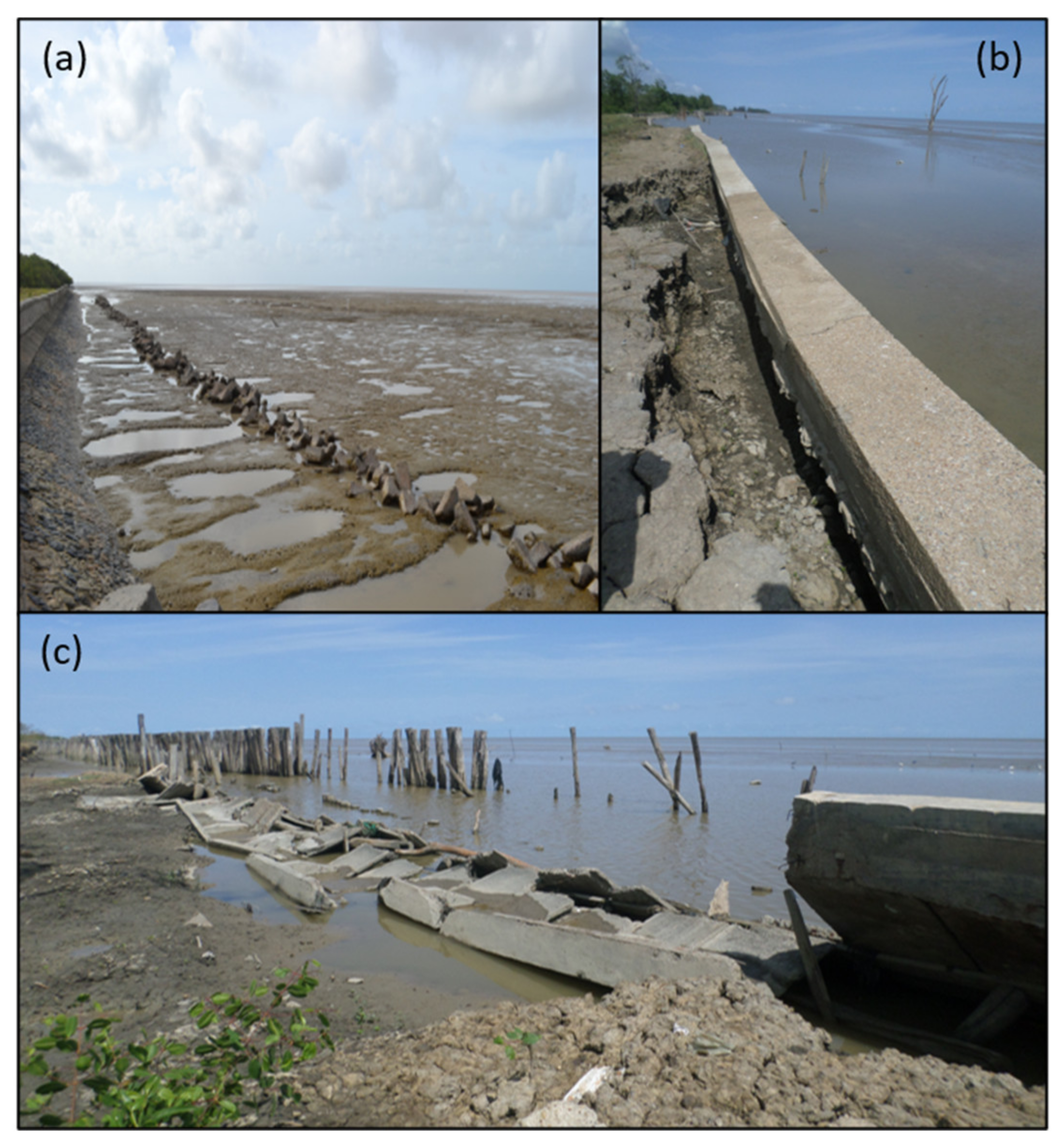
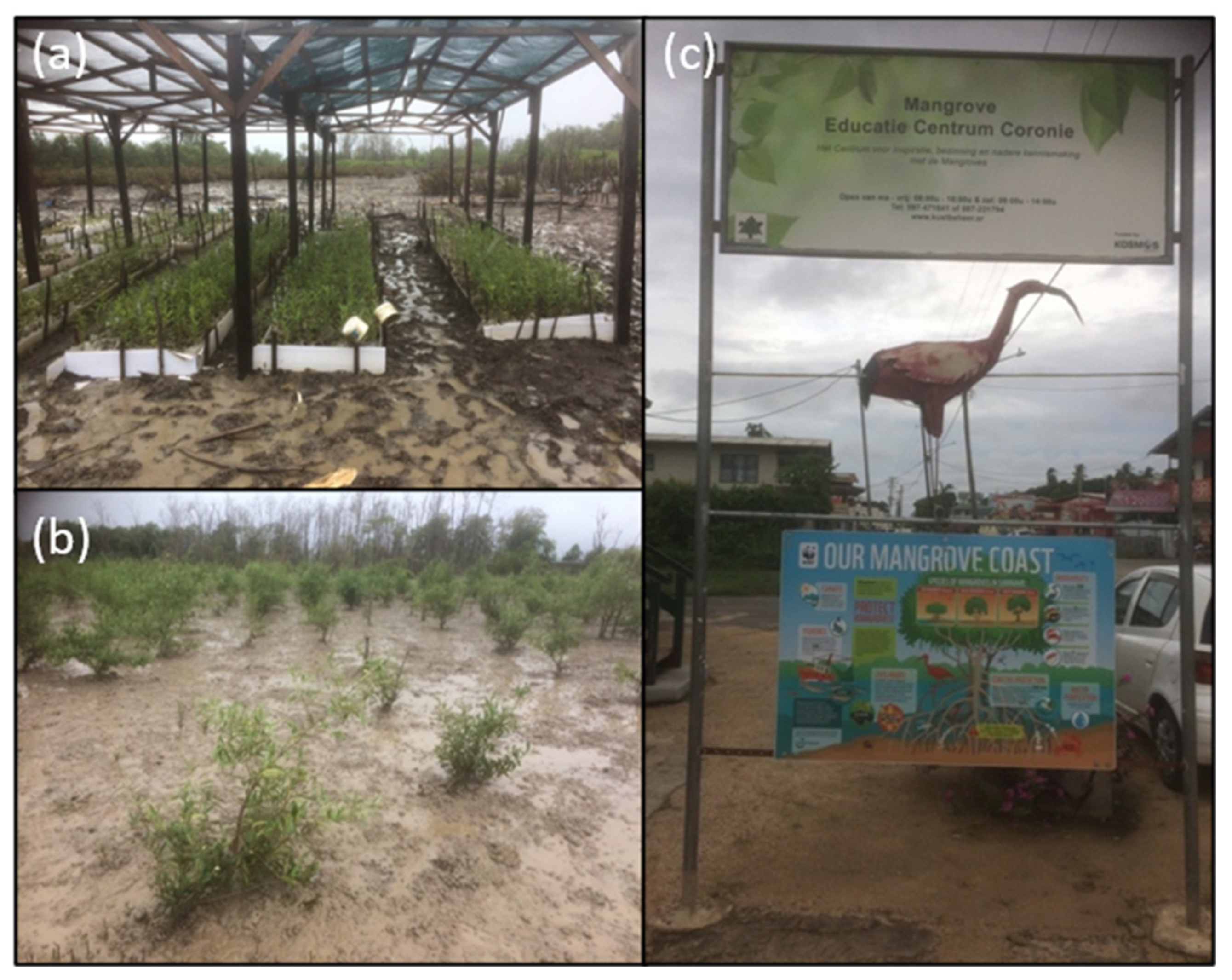
  105. Anthony, E.J.; Gratiot, N. Coastal engineering and large-scale mangrove destruction in Guyana, South America: Averting an environmental catastrophe in the making. Ecol. Engin. 2012, 47, 268–273. [Google Scholar] [CrossRef]
  106. Winterwerp, J.C.; Erftemeijer, P.L.A.; Suryadiputra, N.; Van Eijk, P.; Zhang, L.-Q. Defining eco-morphodynamic requirements for rehabilitating eroding mangrove-mud coasts. Wetlands 2013, 33, 515–526. [Google Scholar] [CrossRef]
  107. Toorman, E.; Anthony, E.J.; Augustinuus, P.G.E.F.; Gardel, A.; Gratiot, N.; Homenauth, O.; Huybrechts, N.; Monbaliu, J.; Moseley, K.; Naipal, S. Interaction of mangroves, coastal hydrodynamics and morphodynamics along the coastal fringes of the Guianas. In Threats to Mangrove Forests: Hazards, Vulnerability and Management Solutions; Makowski, C., Finkl, C., Eds.; Coastal Research Library-Springer: Dordrecht, The Netherlands, 2017; Volume 25, pp. 429–473. [Google Scholar]
  108. Johhnson-Bhola, L.; Oyedotun, T.D.T. Coastal defence roles of mangroves on the Amazon-influenced coast of Guyana, South America: A review of an intervention project on an eroding coastline. Zone 2017, 20, 12–14. [Google Scholar]
  109. Anthony, E.J. Assessment of Peri-Urban Coastal Protection Options in Paramaribo-Wanica, Suriname; WWF Guianas: Georgetown, Guyana, 2015; p. 55. Available online: https://wwflac.awsassets.panda.org/downloads/2__16_02_project_peri_urban_coastal_protection_options_paramaribo___final_report_edward_.pdf (accessed on 17 February 2021).
  110. De Jong, S.M.; Shen, Y.; de Vries, J.; Bijnaar, G.; van Maanen, B.; Augustinus, P.; Verweij, P. Mapping mangrove dynamics and colonization patterns at the Suriname coast using historic satellite data and the LandTrendr algorithm. Int. J. Appl. Earth Obs. Geoinf. 2020, 97, 102293. [Google Scholar] [CrossRef]
  111. Anthony, E.J.; Dolique, F. Morphological response of embayed sandy beaches to Amazon-derived mud banks, Cayenne, French Guiana: A short- to long-term perspective. Mar. Geol. 2004, 208, 249–264. [Google Scholar] [CrossRef]
  112. Brunier, G.; Fleury, J.; Anthony, E.J.; Gardel, A.; Dussouillez, P. Close-range airborne Structure-from-Motion Photogrammetry for high-resolution beach morphometric surveys: Examples from an embayed rotating beach. Geomorphology 2016, 261, 76–88. [Google Scholar] [CrossRef]
  113. Jolivet, M.; Anthony, E.J.; Gardel, A.; Brunier, G. Multi-decadal to short-term beach and shoreline mobility in a complex river-mouth environment affected by mud from the Amazon. Front. Earth Sci. 2019, 7, A187. [Google Scholar] [CrossRef] [Green Version]
Figure 1. Digital elevation model from ETOPO1 (a) and Landsat mosaic (September to November 2017) of the lower Amazon River from Óbidos to the mouths (b); South American setting showing the Amazon River basin (green) and the Guianas countries (purple) influenced by Amazon sediments, including the mouths of the Orinoco River basin (orange) (c).
Water 13 01371 g001
Figure 2. MERIT digital elevation model (DEM) of the Amazon delta. The MERIT DEM [39] is available for download at http://hydro.iis.u-tokyo.ac.jp/~yamadai/MERIT_DEM/, accessed on 15 February 2021. The DEM represents elevation in meters, referenced to WGS84 and EGM96. The data are prepared as 5 degree × 5 degree tiles (6000 pixel × 6000 pixel). The authors of [39] separated absolute bias, stripe noise, speckle noise, and tree height bias using multiple satellite datasets and filtering techniques. After the error removal, land areas mapped with 2 m or better vertical accuracy were increased from 39% to 58%. Significant improvements were found in flat regions where height errors larger than topography variability, and landscapes such as river networks and hill-valley structures became clearly represented. The DEM also shows the continuum of changing water levels from Óbidos to the northern part of the river mouth and aspects of sedimentation in this continuum identified by [40].
Water 13 01371 g002
Figure 3. Various categories of land-water and water-land conversion in the Amazon River delta between 1984 and 2015 generated by [51], downloaded from the European Union’s https://global-surface-water.appspot.com/download (accessed 15 February 2021) and superimposed on a Copernicus Sentinel 2 satellite image dated 15 October 2019.
Water 13 01371 g003
Figure 4. Sea-level rise projections by 2100 for two scenarios with mild (3 m) and extreme (5 m) rises. Downloaded on 16 March 2021 from Earth Org (https://earth.org/data_visualization/sea-level-rise-by-2100-amazon-river-delta/2021, accessed on 15 February 2021 ). Map based on sea-level rise scenarios forecast by Climate Central—Coastal Risk Screening Tool (https://coastal.climatecentral.org/map/3/85.7984/25.273/?theme=sea_level_rise&map_type=year&basemap=roadmap&contiguous=true&elevation_model=best_available&forecast_year=2050&pathway=rcp45&percentile=p50&refresh=true&return_level=return_level_1&slr_model=kopp_2014, accessed on 15 February 2021).
Water 13 01371 g004
Figure 5. The Amazon delta as a coupled social-ecological system (SES): Boundaries and interconnections/telecoupling dimensions. From [2] with permission from Springer.
Water 13 01371 g005
Figure 6. Illustrative application of the framework to map out the impact of urban growth and pollution on small-scale fisheries in riparian areas and mangroves of the Amazon delta. From [2] with permission from Springer.
Water 13 01371 g006
Figure 7. Copernicus Sentinel 2 satellite image (29 October 2019) showing a mud bank in transit along the coast of central French Guiana between the cities of Cayenne (capital of French Guiana) and Kourou (satellite launching pad of the European Union). This is part of a belt of up to 20 mud banks migrating at any time along the Guianas coast just north of the mouths of the Amazon to the mouths of the Orinoco River delta in Venezuela.
Water 13 01371 g007
Figure 8. Photographs of damaged and ineffective concrete dykes in Guyana in May, 2012 (a), and Suriname in October 2015 (b,c). The Guyana dyke is fronted by a deepened, concave foreshore erosion profile caused by wave reflection and offshore dispersal of mud. The poorly designed Suriname dykes were built just two years before the photo was taken at Weg Naar Zee, near Paramaribo, and were not subsequently maintained.
Water 13 01371 g008
Figure 9. (a) Mangrove nursery and replanted plot (b) in Paramaribo, at the initiative of Professor Sieuwnath Naipal, Anton de Kom University, Paramaribo, Suriname, and (c) a mangrove school in Coronie, Suriname.
Water 13 01371 g009
Table 1. Geomorphic area (defined as both land and water), habitable area (land area), and population increases in the Amazon delta [8], and 2020 population density [11,12].
Delta Area (km2)LandScan Population Data
Geomorphic AreaHabitable AreaPopulation Year 2000Population Year 2010Population Year 2020
84,429.4258,747.72375,797646,335746,287
Including metropolitan area of the cities of Belém and Macapá3.3 mi4 mi4.3 mi
Publisher’s Note: MDPI stays neutral with regard to jurisdictional claims in published maps and institutional affiliations.

