
Ionic Runoff as a Way to Determine the Degree of Karst Denudation (Case Study Jasov Plateau, Slovak Karst, Slovakia)

 ,
,  ,
,
Abstract
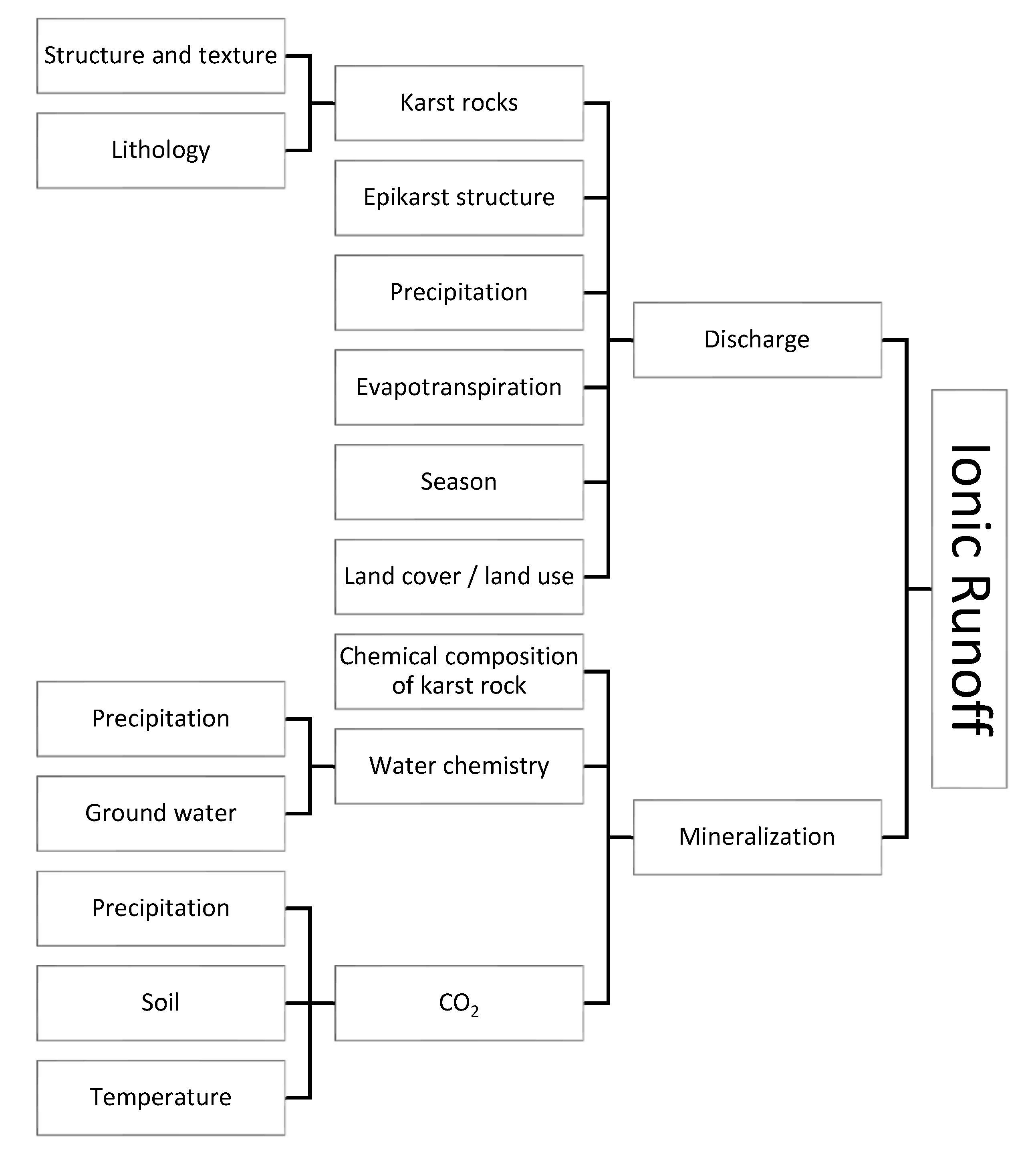
:1. Introduction
2. Study Area
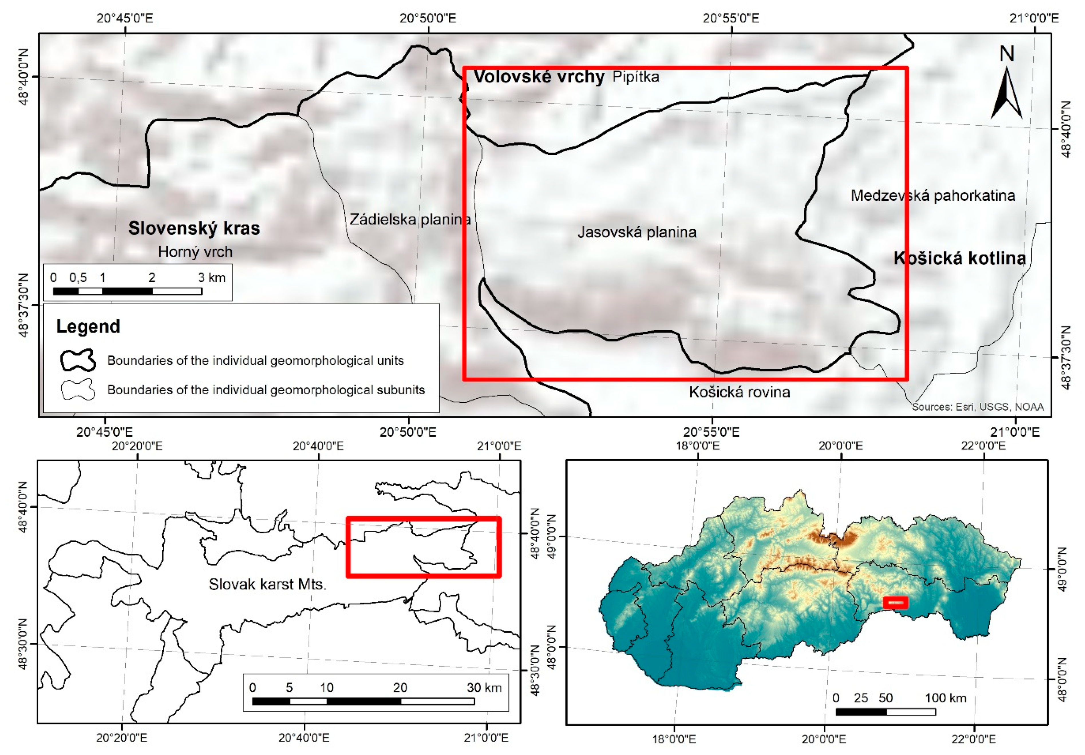
2.1. Geographical and Climatic Setting
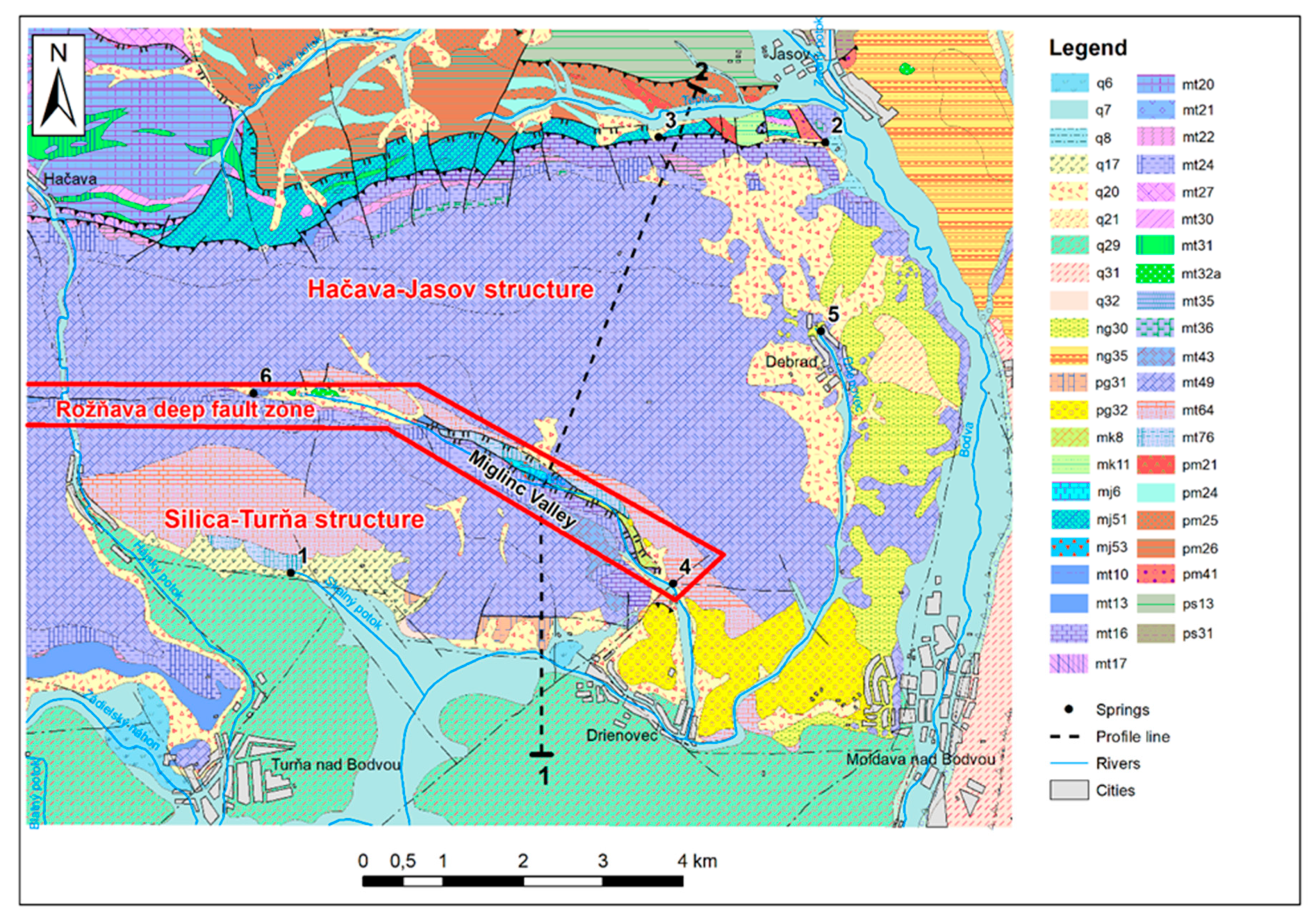
2.2. Geological and Hydrogeological Settings of the Jasov Plateau


2.3. Studied Springs
3. Materials and Methods
3.1. Fieldwork and Sampling
3.2. Karst Water Characteristics
3.3. Calculation of Ionic Runoff
4. Results
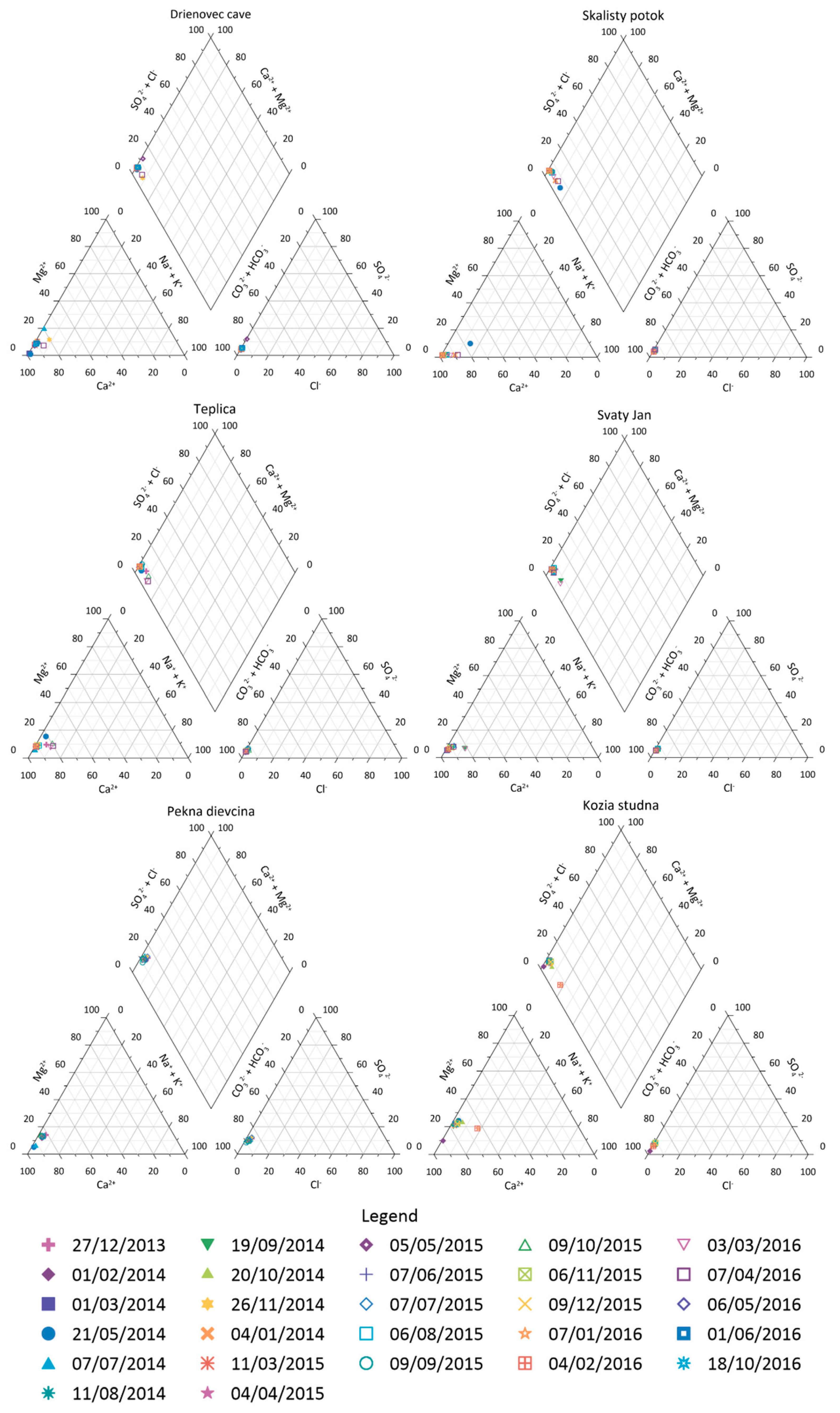
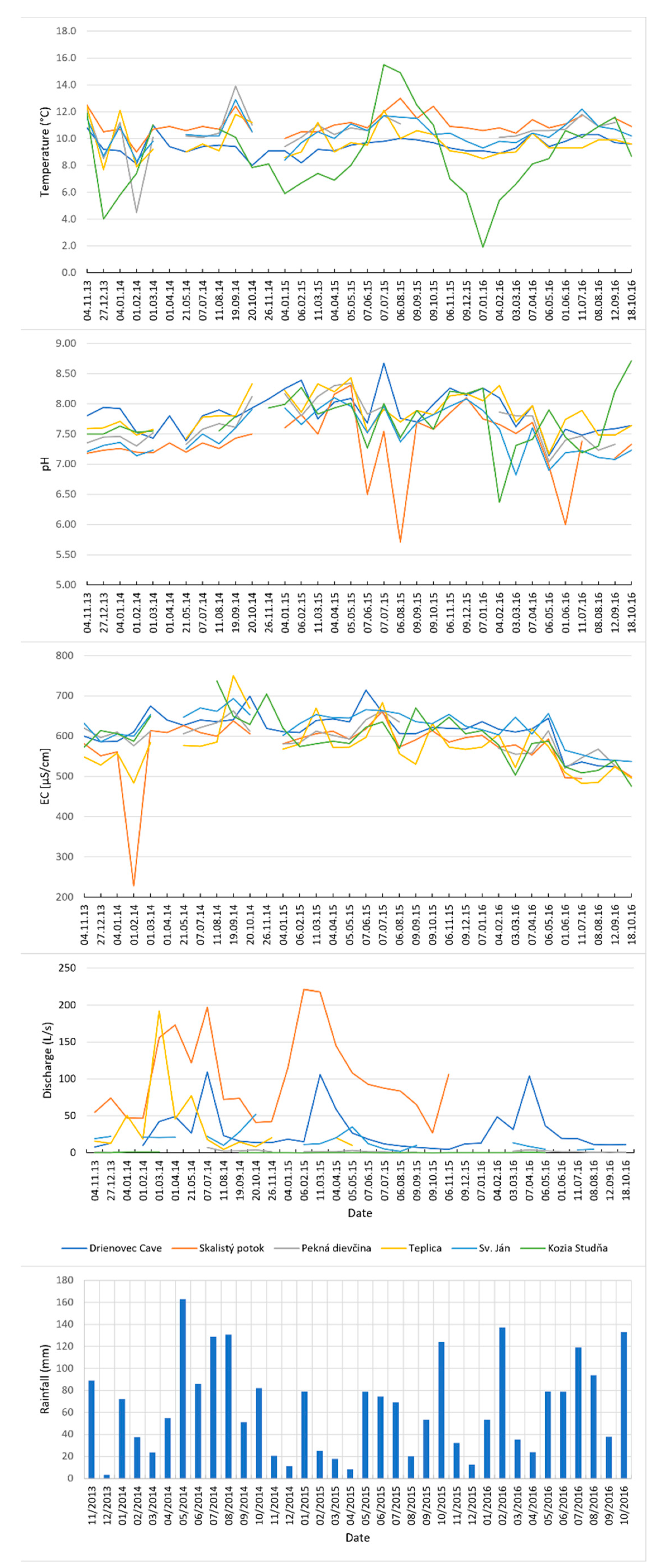
4.1. Hydrochemistry of the Karst Water
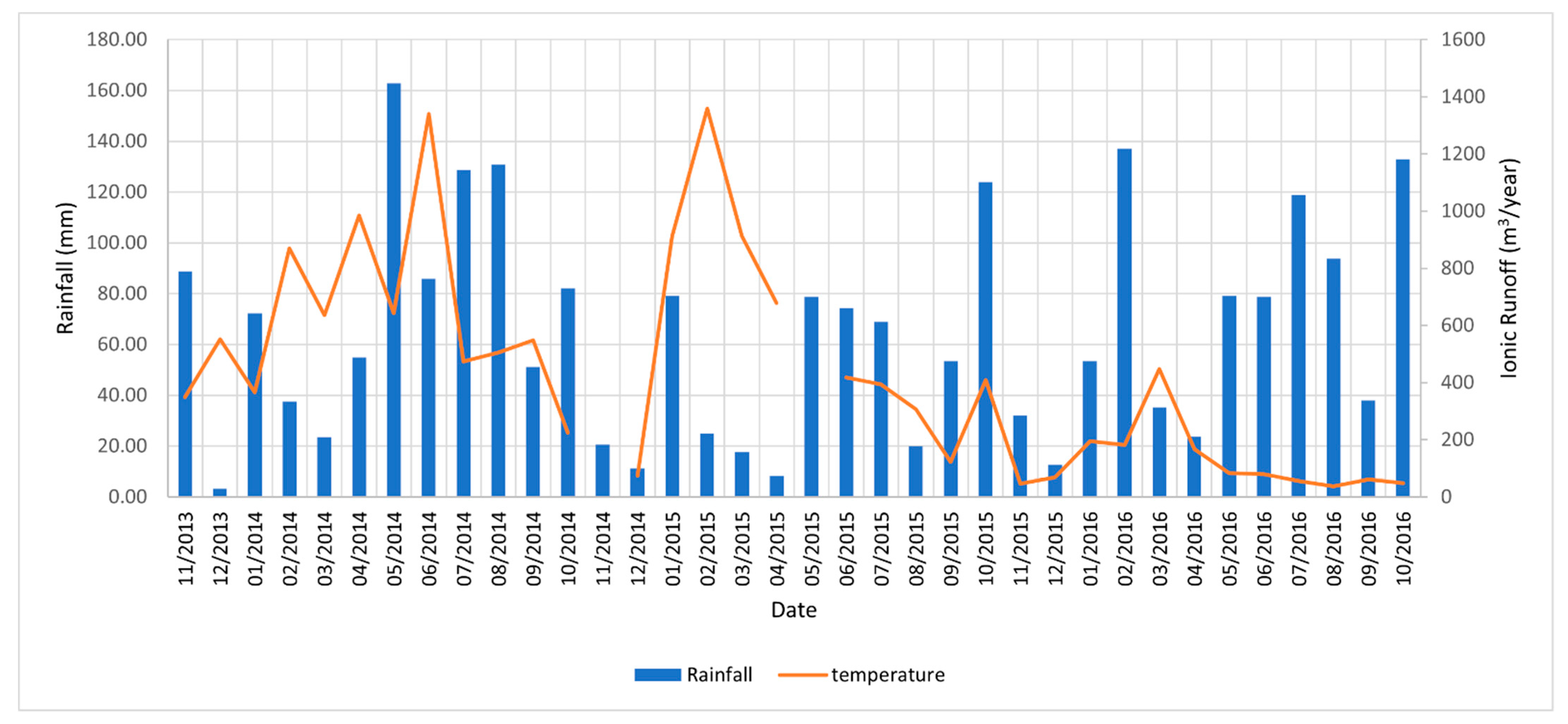
4.2. Ionic Runoff
- (a)
- Skalistý potok 29.44 g/s, 370.92 m3/year,
- (b)
- Pekná dievčina 0.55 g/s, 6.88 m3/year,
- (c)
- Teplica 7.50 g/s, 94.50 m3/year,
- (d)
- Drienovec Cave 8.34 g/s, 105.08 m3/year,
- (e)
- Sv. Ján 4.85 g/s, 61.11 m3/year,
- (f)
- Kozia studňa 0.067 g/s, 0.84 m3/year.
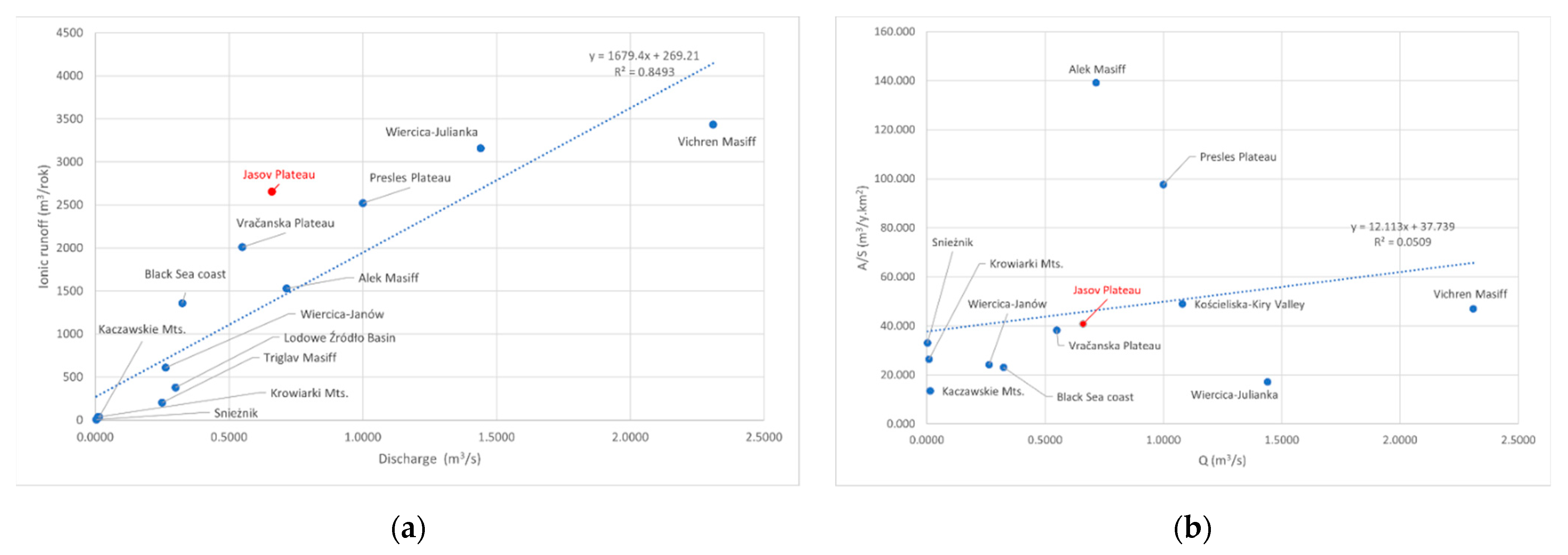
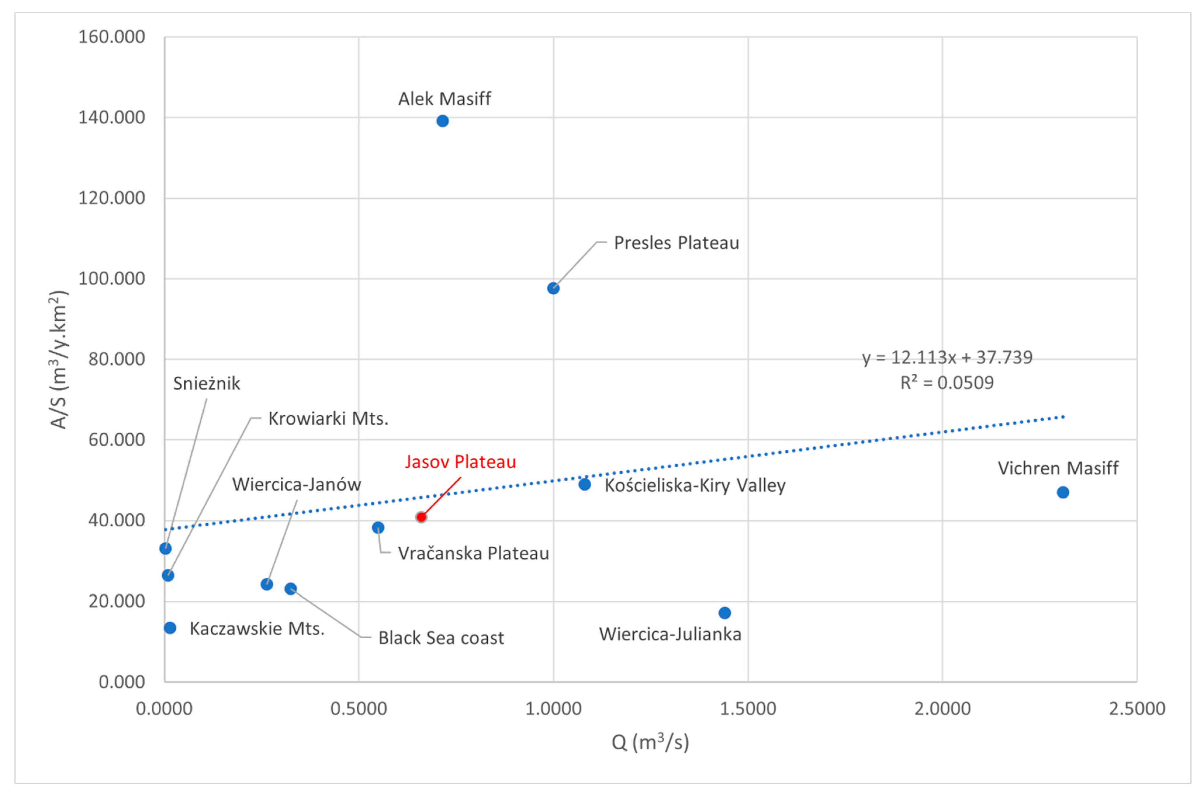
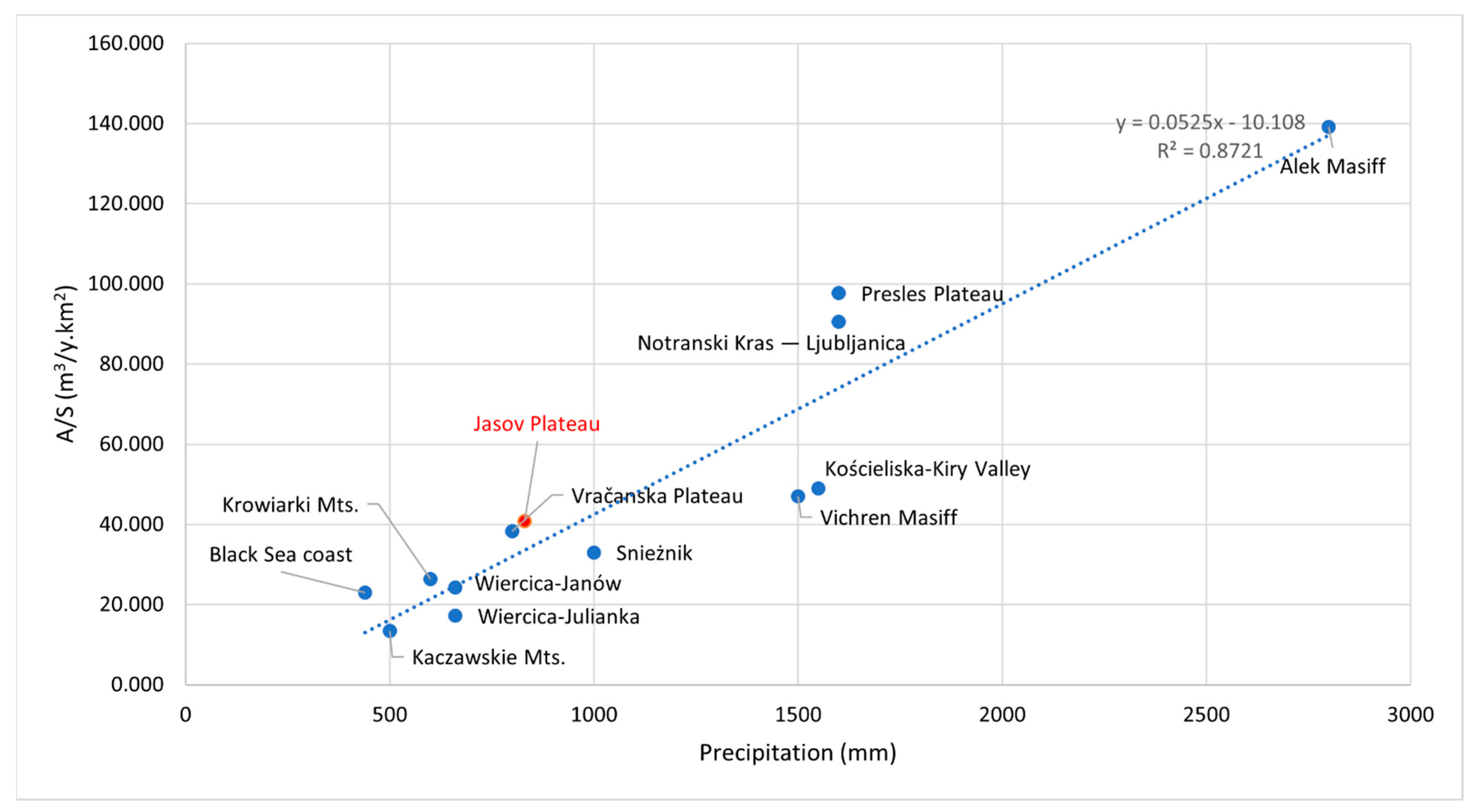
5. Discussion
6. Conclusions
Supplementary Materials
Author Contributions
Funding
Institutional Review Board Statement
Informed Consent Statement
Data Availability Statement
Acknowledgments
Conflicts of Interest
References
- Dreybrodt, W. Processes in Karst Systems: Physics, Chemistry, and Geology; Springer: Berlin, Germany; New York, NY, USA, 1988; Volume 12. [Google Scholar]
- Ford, D.C.; Williams, P.W. Karst Geomorphology and Hydrology; Unwin Hyman: London, UK, 1989. [Google Scholar]
- White, W.B. Geomorphology and Hydrology of Karst Terrains; Oxford University Press: New York, NY, USA, 1988. [Google Scholar]
- Fischer, A.G. Geological time-distance rates—The Bubnoff unit. Geol. Soc. Am. Bull. 1969, 80, 549–551. [Google Scholar] [CrossRef]
- Pulina, M. Denudacja Chemiczna na Obszarach Krasu Węglanowego (Sum. Chemical Denudation on the Carbonate Karst Areas); Prace Geograficzne PAN; Ossolineum: Wrocław, Poland, 1974. [Google Scholar]
- Corbel, J. Erosion en terrain calcaire—Vitesse d’érosion et morphologie. Ann. Géographie 1959, 68, 97–120. [Google Scholar] [CrossRef]
- Gabrovšek, F. On concepts and methods for the estimation of dissolutional denudation rates in karst areas. Geomorphology 2009, 106, 9–14. [Google Scholar] [CrossRef]
- Plan, L. Factors controlling carbonate dissolution rates quantified in a field test in the Austrian Alps. Geomorphology 2005, 68, 201–212. [Google Scholar] [CrossRef]
- High, C.J.; Hanna, F.K. A method for the direct measurement of erosion on rock surfaces. Br. Geomorphol. Res. Group Tech. Bull. 1970, 5, 1–25. [Google Scholar]
- Cucchi, F.; Forti, P.; Ulcigrai, F. Valori di abbassamento per dissoluzione carsiche. Acta Carsol./Karsoslovni Zb. 1994, 23, 55–62. [Google Scholar]
- Lauritzen, S.E. A Simple Growth Model for Allogenic Pedestals in Glaciated Karst. In Proceedings of the 14th International Congress of Speleology, Athen-Kalamos, Greece, 21–28 August 2005; pp. 1–5. [Google Scholar]
- Stone, J.O.H.; Evans, J.M.; Fifield, L.K.; Allan, G.L.; Cresswell, R.G. Cosmogenicchlorine-36 production in calcite by muons. Geochim. Cosmochim. Acta 1998, 62, 433–454. [Google Scholar] [CrossRef]
- Smith, D.I.; Newson, M.D. The Dynamics of Solutional and Mechanical Erosion in Limestone Chatchments on the Mendip Hills, Somerset. In Fluvial Porcesses in Instrumented Watersheds; Institute of British Geographers: Lodon, UK, 1974; Special Publication 6; pp. 155–167. [Google Scholar]
- Priesnitz, K. Losungsraten und ihre geomorphologische relevanz. Abh. Akad. Wiss. Göttingen, Math. Phys. Kl 1974, 3, 68–84. [Google Scholar]
- Gams, I. Faktorji in dinamika korozije na karbonatnih kameninah Slovenskega Dinarskega in Alpskega krasa. Geogr. Vestn. 1967, 38, 11–68. [Google Scholar]
- Appelo, C.A.J.; Postma, D. Geochemistry, groundwater and pollution: Rotterdam. AA Balkema 1993, 536, 237–247. [Google Scholar]
- Gabrovšek, F. On denudation rates in karst. Acta Carsol. 2007, 36, 9–14. [Google Scholar] [CrossRef]
- Shopov, Y.; Stoykova, D.; Tsankov, L.T.; Marinova, E.; Sauro, U.; Borsato, A.; Cucchi, F.; Forti, P.; Piccini, L.; Ford, D.C.; et al. Past Annual Variations of the Karst Denudation Rates. In Larst, Climate Change and Groundwater; Serie: Hidrogeología y aguas subterráneas; Publicaciones del Instituto Geologico y minero de Espana: Madrid, Spain, 2009; pp. 487–494. [Google Scholar]
- Rzonca, B.; Buczyński, S. Intense karst denudation in a crystalline basin with a small share of carbonate rocks (Sudety Mountains, SW Poland). CATENA 2013, 107, 154–164. [Google Scholar] [CrossRef]
- Yan, J.; Li, J.; Ye, Q.; Li, K. Concentrations and exports of solutes from surface runoff in Houzhai karst basin, southwest China. Chem. Geol. 2012, 304–305, 1–9. [Google Scholar] [CrossRef]
- Pulina, M.; Postnov, I. Kras gipsowy w północno—Zachodniej części Ziemi Nordenskiolda–Zachodni Spitsbgergen. Kras Speleol. 1989, 6, 40–57. [Google Scholar]
- Pulina, M. Grønfjord—Barentsburg. In Proceedings of the Funkcjonowanie Dawnych I Współczesnych Geoekosystemów Spitsbergenu, Poznań-Longyerbyen, Poland, 10–21 July 2003; pp. 173–176. [Google Scholar]
- Pulina, M.; Fagundo, J.R. Tropical karst and chemical denudation of western Cuba. Geogr. Pol. 1992, 60, 195–216. [Google Scholar]
- Tsakiris, G.; Spiliotis, M.; Paritsis, S.; Alexakis, D. Assessing the water potential of karstic saline springs by applying a fuzzy approach: The case of Almyros (Heraklion, Crete). Desalination 2009, 237, 54–64. [Google Scholar] [CrossRef]
- Himmel, J. Variabilita intenzity krasovění v zóně vertikální cirkulace v podmínkách Moravského krasu. Geolog. Výzk. Mor. Slez. Roce 2006, 1999, 144–149. [Google Scholar]
- Himmel, J. Intenzita krasovění vápenců zóny vertikální krasové cirkulace v Moravském krasu. Speleo 2000, 29, 12–17. [Google Scholar]
- Štelcl, O.; Vlček, V.; Panovský, K. Intenzita koroze různých typů karbonátových Hornin v ČSR. Ceskoslov. Kras 1976, 28, 29–46. [Google Scholar]
- Roda, Š.; Rajman, L.; Erdös, M.; Szabová, T. Vznik a Vývoj Sintrových Foriem v Piatich Jaskyniach Slovenského Krasu; Gemerská Vlastivedná Spoločnosť: Rimavská Sobota, Slovakia, 1986. [Google Scholar]
- Droppa, A. Intenzita korózie krasových tokov v Demänovskej doline (Corrosion intensity of karst streams in the Demänovská Dolina valley). Slov. Kras 1976, 14, 3–30. [Google Scholar]
- Droppa, A. Intenzita korózie tokov v Jánskej doline (The intensity of stream corrosion in the Jánska Dolina valley). Slov. Kras 1978, 16, 39–67. [Google Scholar]
- Droppa, A. Korózny Účinok Krasových Tokov Na Severnej Strane Nízkych Tatier; Slovenský Kras; SMOPAJ: Liptovský Mikuláš, Slovakia, 2012; Supplementum 1. [Google Scholar]
- Hochmuth, Z.; Vadelová, I. Výskum kvantitatívnych aspektov povrchovej korózie krasových hornín v Slovenskom raji a Slovenskom krase. Slov. Kras 2010, 48, 241–251. [Google Scholar]
- Hochmuth, Z.; Gessert, A. The Jasov Plateau in the Slovak Karst as an Experimental Area for the Denudation Dynamic Research. In Proceedings of the 17th International Congress of Speleology; Australian Speleological Federation: Sydney, Australia, 2017; Volume 2, pp. 38–42. [Google Scholar]
- Sládek, I. Predbežné výsledky výskumu vplyvu obsahu dolomitovej zložky vo vápencoch východnej časti Slovenského krasu na proces krasovej korózie. Geogr. Cassoviensis 2014, 2, 173–180. [Google Scholar]
- Peel, M.C.; Finlayson, B.L.; McMahon, T.A. Updated world map of the Köppen-Geiger climate classification. Hydrol. Earth Syst. Sci. 2007, 11, 1633–1644. [Google Scholar] [CrossRef] [Green Version]
- Gessert, A. Geomorphology of the Slovak karst (eastern part). J. Maps 2016, 12, 285–288. [Google Scholar] [CrossRef]
- Gaál, Ĺ. Geodynamika a Vývoj Jaskýň Slovenského Krasu; Štátna ochrana prírody SR, Správa Slovenských Jaskýň: Banská Bystrica, Slovakia, 2008; ISBN 80-8064-330-X. [Google Scholar]
- Hochmuth, Z. Atlas Jaskyne Skalistý Potok; Slovenská Speleologická Spoločnosť: Liptovský Mikuláš, Slovakia, 2013. [Google Scholar]
- Hochmuth, Z.; Petrvalská, A. Exokarst Forms of the Jasovská Plateau; Ostravská univerzita v Ostravě: Ostrava, Czech Republic, 2010; pp. 15–19. [Google Scholar]
- Lešinský, G. Výsledky speleologickej inventarizácie na Jasovskej planine v Slovenskom krase. Slov. Kras 2002, 40, 137–173. [Google Scholar]
- Petrvalská, A. Reliéf Jasovskej Planiny v Slovenskom Krase; PJ Šafárik University: Košice, Slovakia, 2014; p. 112. [Google Scholar]
- Longest Caves of Slovakia. 2020. Available online: https://sss.sk/tabulka-najdlhsich-jaskyn-na-slovensku/ (accessed on 11 May 2011).
- Climate Atlas of Slovak Republic. Available online: http://klimat.shmu.sk/kas/ (accessed on 18 March 2021).
- Mello, J.; Pristaš, J.; Reichwalder, P.; Snopko, L.; Vass, D.; Vozárová, A.; Gaál, Ľ.; Hanzel, V.; Hók, J.; Kováč, P. Vysvetlivky Ku Geologickej Mape Slovenského Krasu 1:50,000; Vydavateľstvo Dionýza Štúra: Bratislava, Slovakia, 1997; ISBN 80-85314-64-9. [Google Scholar]
- Zacharov, M. Geologické a tektonické pomery drienovskej Jaskyne v Slovenskom krase. Slov. Kras 2008, 46, 41–52. [Google Scholar]
- Podmienky Využívania a Ochrany Podzemných Vôd Slovenského Krasu. In Puklinové a Puklinovo-Krasové Vody a Problémy Ich Ochrany; GÚDŠ: Bratislava, Slovakia, 1984; pp. 107–115.
- Zacharov, M. Význam regionálnych tektonických štruktúr vo východnej časti Slovenského krasu pre vznik a vývoj jaskýň. Slov. Kras 2012, 50, 11–30. [Google Scholar]
- Mello, J.; Elečko, M.; Pristaš, J.; Reichwalder, P.; Snopko, L.; Vass, D.; Vozárová, A. Geologická Mapa Slovenského Krasu 1:50,000; MŽP SR, GS SR: Bratislava, Slovakia, 1996. [Google Scholar]
- Šuba, J. Evidencia Vodných Zdrojov a Jej Budovanie. Publ. ČSVTS: Bratislava, Slovakia, 1979; p. 8. [Google Scholar]
- Šuba, J. Slovenský Kras a Turnianska Kotlina, Vyhľadávací Hydrogeologický Prieskum; Manuskript–Archív Geologickej Služby SR: Bratislava, Slovakia, 1973; p. 91. [Google Scholar]
- Gessert, A.; Straková, V.; Palcsu, L.; Koltai, G.; Braun, M.; Heim, E.; Czébely, A. Differences in temporal changes of selected water quality parameters on Jasovská planina plateau (Slovak karst, Slovakia). GC 2019, 13, 5–20. [Google Scholar] [CrossRef] [Green Version]
- Fľaková, R.; Ženišová, Z.; Seman, M. Chemická Analýza Vody v Hydrogeológii; Slovenská Asociácia Hydrogeológov: Bratislava, Slovakia, 2010; ISBN 978-80-969342-8-7. [Google Scholar]
- Parkhurst, D.L.; Appelo, C.A.J. Description of Input and Examples for PHREEQC Version 3: A Computer Program for Speciation, Batch-Reaction, One-Dimensional Transport, and Inverse Geochemical Calculations; US Geological Survey: Lakewood, CO, USA, 2013.
- Lewin, J.; Woodward, J. The Physical Geography of the Mediterranean; Oxford University Press: Oxford, UK, 2009; ISBN 978-0-19-926803-0. [Google Scholar]
- Palcsu, L.; Gessert, A.; Túri, M.; Kovács, A.; Fúto, I.; Orsovszki, J.; Puskás-Preszner, A.; Temovski, M.; Koltai, G. Long-term time series of environmental tracers to reveal recharge and discharge conditions in shallow karst aquifers in Hungary and Slovakia. J. Hydrol. Reg. Stud. Submitted.
- Stroj, A.; Briški, M.; Oštrić, M. Study of groundwater flow properties in a karst system by coupled analysis of diverse environmental tracers and discharge dynamics. Water 2020, 12, 2442. [Google Scholar] [CrossRef]
- Lánczos, T.; Filipčíková, N. Speleogenetický význam CO2 pre vývoj vybraných jaskýň plaveckého krasu v Malých Karpatoch. Slov. Kras 2017, 55, 5–22. [Google Scholar]
- Malík, P.; Michalko, J.; Rapant, S.; Scherer, S. Izotopy síry v zimných zrážkach na území Slovenska. Podzemná Voda 2000, 6, 174–184. [Google Scholar]
- Kukuljan, L.; Gabrovšek, F.; Covington, M.D.; Johnston, V.E. CO2 dynamics and heterogeneity in a cave atmosphere: Role of ventilation patterns and airflow pathways. 2021. [Google Scholar] [CrossRef]
- Droppa, A. Vplyv Ročných Období Na Koróziu Demänovského Krasu. In Proceedings of the Zborník Referátov z Vedecké Konferencie, Liptovský Mikuláš, Slovakia, 10–11 October 1995; pp. 63–70. [Google Scholar]
- Himmel, J. Efektivnost infiltrace atmosférických srážek do podzemních vod v Podmínkách Moravského krasu během průměrného roku. Speleo 2000, 30, 19–25. [Google Scholar]
- Gabrovšek, F.; Peric, B. Monitoring the flood pulses in the epiphreatic zone of karst aquifers: The case of Reka river system, Karst plateau, SW Slovenia. Acta Carsol. 2006, 35. [Google Scholar] [CrossRef] [Green Version]


| Area | Average TDS (mg/L) | Average Discharge (L/s) | IR (m3/Year) | |
|---|---|---|---|---|
| Monitored Springs | - | 357.5 | 176.3 | 639.3 |
| Drienovec Main Spring | Drienovec | 421 | 184.0 | 983.4 |
| Hatiny Spring | Hatiny | 218 | 1.0 | 2.7 |
| Dvojičky Spring | Miglinc Valley | 330.5 | 0.1 | 4.2 |
| Perlová studňa Spring | North Slope | 238 | 1.0 | 2.9 |
| Teplica Cave Spring | Jasov-Teplica | 304.2 | 55.5 | 194.3 |
| Teplica Hydrological Object | Jasov-Teplica | 300.2 | 25.6 | 89.4 |
| Mikei Spring | Debraď | 132.1 | 36.3 | 141.4 |
| Čuporka Spring | Debraď | 351.3 | 47.7 | 195.4 |
| Čuporka II. Spring | Debraď | 209.2 | 2.4 | 9.6 |
| Skalistý potok Cave | South slope | 226.7 | 50.8 | 163.0 |
| Gusto Cave | Háj Valley | 106.6 | 47.3 | 147.6 |
| Travertine Spring | Háj Valley | 185.1 | 3.2 | 8.7 |
| Travertine Cave | Háj Valley | 103.6 | 14.0 | 41.9 |
| Triple Spring | Miglinc Valley | 295.2 | 6.2 | 21.9 |
| Stano’s Place | Plateau surface | 65.1 | 0.9 | 3.2 |
| P 07 | Miglinc Valley | 114.1 | 0.4 | 0.8 |
| P 09 | Miglinc Valley | 115.1 | 0.5 | 1.4 |
| P 11 | Miglinc Valley | 320.2 | 1.1 | 3.9 |
| P 12 | Miglinc Valley | 242.2 | 0.7 | 2.1 |
| P 14 | Miglinc Valley | 155.1 | 0.5 | 0.5 |
| P 18 | Miglinc Valley | 311.2 | 1.8 | 6.2 |
| P 21 | Miglinc Valley | 292.2 | 0.1 | 0.4 |
| Pod stromom Spring | Teplica-Jasov | 117.1 | 0.5 | 0.5 |
| Total | - | - | 657.8 | 2664.9 |
| Experimental Site | 1 | 2 | 3 | Year | S | Q | q | TDS | IR | IR/S |
|---|---|---|---|---|---|---|---|---|---|---|
| a.s.l. | °C | mm | km2 | m3 s−1 | L·s−1·km−2 | mg/L | m3/y | m3/y.km2 | ||
| Sudetes (Poland) | ||||||||||
| Snieżnik | 840 | 4.5 | 1000 | 1966–1970 | 0.22 | 0.004 | 16.0 | 169 | 7.4 | 33.036 |
| Krowiarki Mts. | 450 | 7 | 600 | 1965–1966 | 1.40 | 0.010 | 7.0 | 300 | 37 | 26.429 |
| Kaczawskie Mts. | 400 | 7.2 | 500 | 1965–1966 | 2.81 | 0.019 | 5.5 | 306 | 37.9 | 13.488 |
| Jura Krakowsko-Częstochowska (Poland) | ||||||||||
| Wiercica-Julianka | 270 | 6.7 | 660 | 1968 | 183.7 | 1.440 | 7.8 | 175 | 3160 | 17.202 |
| Wiercica-Janów | 320 | 6.7 | 660 | 1968 | 25.20 | 0.263 | 10.4 | 185 | 610 | 24.206 |
| Tatras (Poland) | ||||||||||
| Kościeliska-Kiry Valley | 1450 | 1.8 | 1550 | 1965–1970 | 29.20 | 1.080 | 37.0 | 105 | 1429 | 48.938 |
| Zlewnia Lodowe Źródło | 1500 | 1.5 | 1580 | 1965–1970 | 0.300 | 37.0 | 100 | 378 | ||
| Vercors (France) | ||||||||||
| Plateau Presles | 900 | 7.2 | 1600 | 1967–1968 | 25.80 | 1.000 | 38.8 | 200 | 2520 | 97.674 |
| Julian Alps (Slovenia) | ||||||||||
| Triglav | 1800 | −1.7 | 2120 | 1965 | 0.250 | 60.0 | 204.7 | |||
| Plateau Kras (Slovenia) | ||||||||||
| Notranski Kras—Ljubljanica | 900 | 7.2 | 1600 | 1962–1969 | 1915 | 71.00 | 37.0 | 194 | 173.5.103 | 90.601 |
| Piryn (Bulgaria) | ||||||||||
| Vichren Massif | 1900 | 3.5 | 1500 | 1967, 1969 | 73.00 | 2.309 | 31.6 | 118 | 3433 | 47.027 |
| Stara Planina (Bulgaria) | ||||||||||
| Vracanska Planina | 800 | 9.0 | 800 | 1967, 1969 | 52.50 | 0.550 | 10.5 | 300 | 2010 | 38.286 |
| Dobrudza (Bulgaria) | ||||||||||
| Black Sea Coast | 100 | 12.5 | 440 | 1967, 1969 | 59.00 | 0.325 | 5.5 | 332 | 1360 | 23.051 |
| Caucasus (Russia) | ||||||||||
| Alek Massif | 800 | 9.5 | 2800 | 1970 | 11.00 | 0.715 | 65.0 | 170 | 1531 | 139.182 |
| Slovakia | ||||||||||
| Slovak Karst, Jasov Plateau | 600 | 8.0 | 600 | 2013–2016 | 65.00 | 0.660 | 10.1 | 355.2 | 2664.94 | 40.847 |
| Rainfall (mm) | pH | TDS µS/cm | Na | K | Mg | Ca | CI | NH4 | NO3 | S04 | Zn | Fe | Al | Mn | F | HCO3 |
|---|---|---|---|---|---|---|---|---|---|---|---|---|---|---|---|---|
| 438.1 | 5.73 | 40.8 | 0.8 | 0.31 | 0.38 | 0.37 | 1.01 | 0.53 | 0.92 | 2.63 | 492 | 0.05 | 0.1 | 18 | 36 | 3.5 |
Publisher’s Note: MDPI stays neutral with regard to jurisdictional claims in published maps and institutional affiliations. |
© 2021 by the authors. Licensee MDPI, Basel, Switzerland. This article is an open access article distributed under the terms and conditions of the Creative Commons Attribution (CC BY) license (https://creativecommons.org/licenses/by/4.0/).
Share and Cite
Gessert, A.; Sládek, I.; Straková, V.; Braun, M.; Heim, E.; Czébely, A.; Palcsu, L. Ionic Runoff as a Way to Determine the Degree of Karst Denudation (Case Study Jasov Plateau, Slovak Karst, Slovakia). Water 2021, 13, 1449. https://doi.org/10.3390/w13111449
Gessert A, Sládek I, Straková V, Braun M, Heim E, Czébely A, Palcsu L. Ionic Runoff as a Way to Determine the Degree of Karst Denudation (Case Study Jasov Plateau, Slovak Karst, Slovakia). Water. 2021; 13(11):1449. https://doi.org/10.3390/w13111449
Chicago/Turabian StyleGessert, Alena, Imrich Sládek, Veronika Straková, Mihály Braun, Enikő Heim, Andrea Czébely, and László Palcsu. 2021. "Ionic Runoff as a Way to Determine the Degree of Karst Denudation (Case Study Jasov Plateau, Slovak Karst, Slovakia)" Water 13, no. 11: 1449. https://doi.org/10.3390/w13111449