
How Is Climate Change Included in the Implementation of the European Flood Directive? Analysis of the Methodological Approaches of Different Countries


Abstract
:1. Introduction
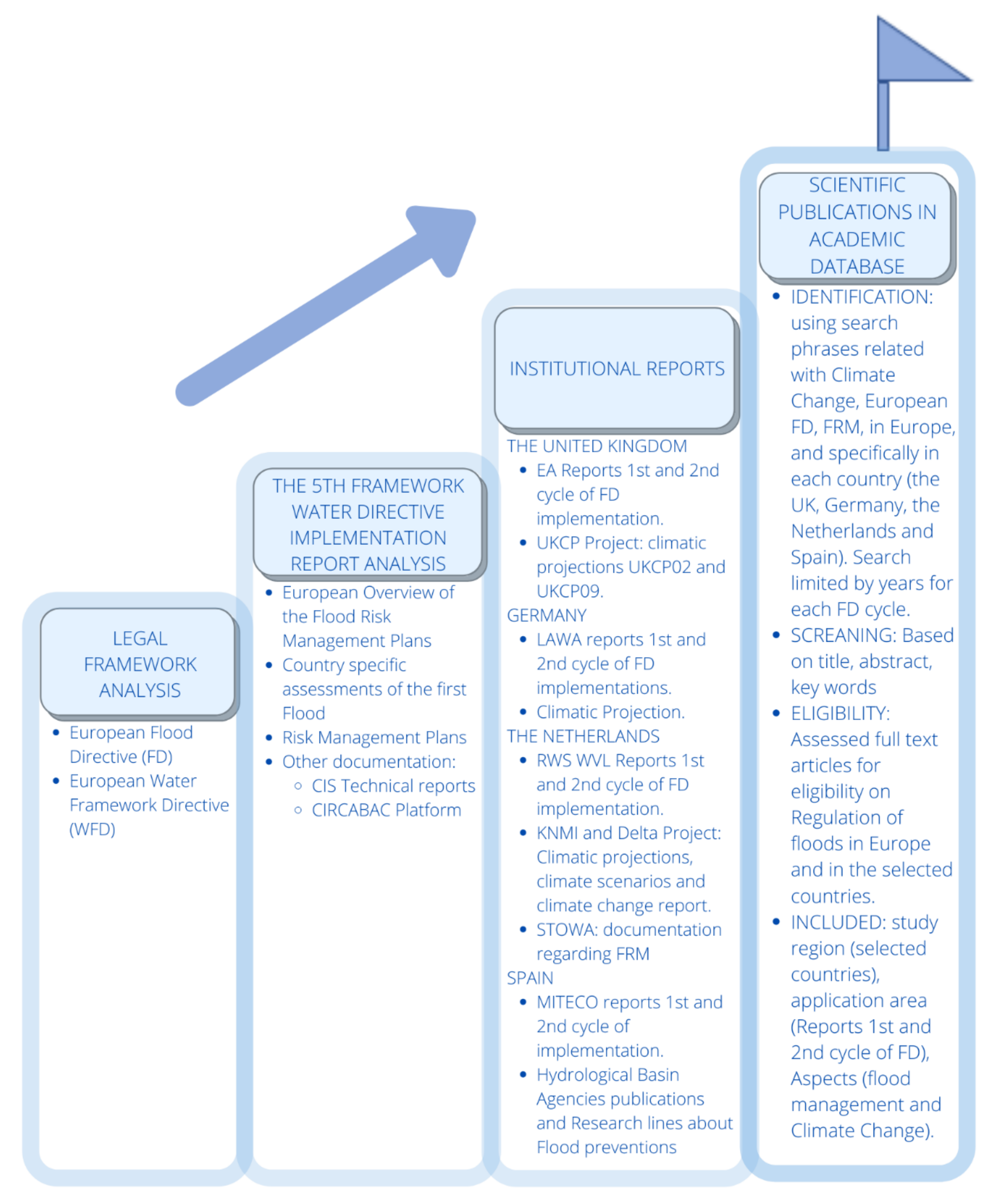
2. Methodology
3. Analysis of the Implementation of Flood Directive
3.1. Prior Approaches from the FM to the Implementation of the Flood Directive
3.1.1. The United Kingdom
3.1.2. Germany
3.1.3. The Netherlands
3.1.4. Spain
3.2. First Cycle of Implementation of the FD
3.2.1. The United Kingdom
3.2.2. Germany
3.2.3. The Netherlands
3.2.4. Spain
3.2.5. First Cycle Summary
3.3. Second Cycle of Implementation of the FD
3.3.1. The United Kingdom
3.3.2. Germany
3.3.3. The Netherlands
3.3.4. Spain
3.3.5. Final Considerations
4. Discussion and Conclusions
Author Contributions
Funding
Institutional Review Board Statement
Informed Consent Statement
Acknowledgments
Conflicts of Interest
Abbreviations
| APSFR | Areas of Potential Significant Flood Risk |
| BfG | Federal Institute of Hydrology of Germany |
| CC | Climate Change |
| CCF | Climate Change Factor |
| CEDEX | Center for Public Works Experimentation Studies |
| CIRCABAC | Communication and Information Resource Center for Administrations Businesses and Citizens |
| CIS | Common Implementation Strategy |
| DTM | Digital Terrain Model |
| EA | The Environment Agency (UK) |
| FD | Flood Directive |
| FHRM | Flood Hazard and Flood Risk Maps |
| FM | Flood Management |
| FRM | Flood Risk Management |
| FRMP | Flood Risk Management Plans |
| GCM | Global climate models |
| GDHI | Gross disposable household income |
| GDP | Gross domestic product |
| GIS | Geographic Information System |
| GMSL | Global mean sea level |
| GVA | Gross value added |
| IPCC | Intergovernmental Panel on Climate Change |
| IPPC | Integrated Pollution Prevention and Control Directive |
| KNMI | The Royal Netherlands Meteorological Institute, “Koninklijk Nederlands Meteorologisch Instituut” |
| LAWA | German Working Group on water issues of the Federal States, “Länder-Arbeitsgemeinschaft Wasser” |
| MITECO | Ministry to the ecological transition and demographic challenge, “Ministerio para la transición ecológica y reto demográfico” |
| NHWSP | German National Flood Protection Program |
| PFRA | Preliminary Flood Risk Assessments |
| RCM | Regional climate models |
| RCP | Representative Concentration Pathways |
| RWS WVL | Ministry of infrastructure and Water Management “Rijkswaterstaat Water, Traffic and Environment” |
| STOWA | Foundation for Applied Research Water Management, “Stichting Toegepast Onderzoek Waterbeheer” |
| UKCP09 | UK regional climate projections 2009 |
| UKCP18 | UK Climate Projections 2018 |
| WFD | Water Framework Directive |
References
- Gralepois, M. What Can We Learn from Planning Instruments in Flood Prevention? Comparative Illustration to Highlight the Challenges of Governance in Europe. Water 2020, 12, 1841. [Google Scholar] [CrossRef]
- Driessen, P.P.J.; Hegger, D.L.T.; Kundzewicz, Z.W.; Van Rijswick, H.F.M.W.; Crabbé, A.; Larrue, C.; Matczak, P.; Pettersson, M.; Priest, S.; Suykens, C.; et al. Governance Strategies for Improving Flood Resilience in the Face of Climate Change. Water 2018, 10, 1595. [Google Scholar] [CrossRef] [Green Version]
- Dieperink, C.; Hegger, D.L.T.; Bakker, M.H.N.; Kundzewicz, Z.; Green, C.; Driessen, P.P.J. Recurrent Governance Challenges in the Implementation and Alignment of Flood Risk Management Strategies: A Review. Water Resour. Manag. 2016, 30, 4467–4481. [Google Scholar] [CrossRef] [Green Version]
- Jiménez Cisneros, B.E.; Oki, T.; Arnell, N.W. Freshwater Resources. In Climate Change 2014—Impacts, Adaptation and Vul-nerability: Part A: Global and Sectoral Aspects: Working Group II Contribution to the IPCC Fifth Assessment Report; Cambridge University Press: Cambridge, UK, 2014; Volume 1, pp. 229–270. [Google Scholar]
- Van Eerd, M.M.C.J.; Dieperink, C.; Wiering, M.M.A. ‘A dive into floods’: Exploring the Dutch implementation of the floods directive. Hydrol. Res. 2014, 17, 187–207. [Google Scholar] [CrossRef]
- Berga Casafont, L. Las inundaciones en España. La nueva Directiva Europea de inundaciones. ROP 2011, 3520, 7–18. [Google Scholar]
- Jara, M.P. The Ascending and Fading of a Progressive Policy Instrument: The Climate Change Factor in Southern Germany. Water 2020, 12, 1050. [Google Scholar] [CrossRef] [Green Version]
- Nones, M.; Pescaroli, G. Implications of cascading effects for the EU Floods Directive. Int. J. River Basin Manag. 2015, 14, 195–204. [Google Scholar] [CrossRef]
- Jacob, D.; Petersen, J.; Eggert, B.; Alias, A.; Christensen, O.B.; Bouwer, L.M.; Braun, A.; Colette, A.; Déqué, M.; Georgievski, G.; et al. EURO-CORDEX: New high-resolution climate change projections for European impact research. Reg. Environ. Chang. 2014, 14, 563–578. [Google Scholar] [CrossRef]
- Bubeck, P.; Kreibich, H.; Penning-Rowsell, E.C.; Botzen, W.J.W.; De Moel, H.; Klijn, F. Explaining differences in flood management approaches in Europe and in the USA—A comparative analysis. J. Flood Risk Manag. 2017, 10, 436–445. [Google Scholar] [CrossRef]
- Van Alphen, J. The Delta Programme and updated flood risk management policies in the Netherlands. J. Flood Risk Manag. 2015, 9, 310–319. [Google Scholar] [CrossRef]
- Du, S.; Shi, P.; Van Rompaey, A.; Wen, J. Quantifying the impact of impervious surface location on flood peak discharge in urban areas. Nat. Hazards 2015, 76, 1457–1471. [Google Scholar] [CrossRef]
- Longobardi, A.; Diodato, N.; Mobilia, M. Historical Storminess and Hydro-Geological Hazard Temporal Evolution in the Solofrana River Basin—Southern Italy. Water 2016, 8, 398. [Google Scholar] [CrossRef] [Green Version]
- Miller, J.D.; Kim, H.; Kjeldsen, T.R.; Packman, J.; Grebby, S.; Dearden, R. Assessing the impact of urbanization on storm runoff in a peri-urban catchment using historical change in impervious cover. J. Hydrol. 2014, 515, 59–70. [Google Scholar] [CrossRef] [Green Version]
- Meng, M.; Dabrowski, M.; Stead, D. Enhancing Flood Resilience and Climate Adaptation: The State of the Art and New Directions for Spatial Planning. Sustainability 2020, 12, 7864. [Google Scholar] [CrossRef]
- Van Ruiten, L.J.; Hartmann, T. The spatial turn and the scenario approach in flood risk management—Implementing the European Floods Directive in the Netherlands. AIMS Environ. Sci. 2016, 3, 697–713. [Google Scholar] [CrossRef]
- Fournier, M.; Larrue, C.; Schellenberger, T. Changes in flood risk governance in France: A David and Goliath story? J. Flood Risk Manag. 2017, 11, 261–270. [Google Scholar] [CrossRef]
- EU (European Union). Directive 2007/60/EC of the European Parliament and of the Council of 23 October 2007 on the Assessment and Management of Flood Risks. Off. J. Eur. Union 2007, L 288, 27–34. [Google Scholar]
- Nones, M. Implementation of the floods directive in selected EU member states. Water Environ. J. 2015, 29, 412–418. [Google Scholar] [CrossRef]
- Hedelin, B. The EU floods directive in Sweden: Opportunities for integrated and participatory flood risk planning. J. Flood Risk Manag. 2015, 10, 226–237. [Google Scholar] [CrossRef]
- Olcina, J.; Sauri, D.; Hernández-Hernández, M.; Ribas, A. Flood policy in Spain: A review for the period 1983–2013. Disaster Prev. Manag. Int. J. 2016, 25, 41–58. [Google Scholar] [CrossRef]
- Hartmann, T.; Spit, T. Implementing the European flood risk management plan. J. Environ. Plan. Manag. 2015, 59, 1–18. [Google Scholar] [CrossRef]
- Priest, S.; Suykens, C.; Van Rijswick, H.; Schellenberger, T.; Goytia, S.; Kundzewicz, Z.; Van Doorn-Hoekveld, W.; Beyers, J.-C.; Homewood, S. The European Union approach to flood risk management and improving societal resilience: Lessons from the implementation of the Floods Directive in six European countries. Ecol. Soc. 2016, 21. [Google Scholar] [CrossRef] [Green Version]
- EU (European Union). Directive 2000/60/EC of the European Parliament and of the Council of 23 October 2000 Establishing a Framework for Community Action in the Field of Water Policy. Off. J. Eur. Union L 327, 1–72.
- Doll, P.; Jiménez-Cisneros, B.; Oki, T.; Arnell, N.; Benito, G.; Cogley, J.; Jiang, T.; Kundzewicz, Z.; Mwakalila, S.; Nishijima, A. Integrating risks of climate change into water management. Hydrol. Sci. J. 2014, 60, 4–13. [Google Scholar] [CrossRef] [Green Version]
- Adamson, M. Flood risk management in Europe: The EU ‘Floods’ directive and a case study of Ireland. Int. J. River Basin Manag. 2018, 16, 261–272. [Google Scholar] [CrossRef]
- Velasco, M.; Russo, B.; Martínez-Gomariz, E. Integrated Assessment of Climate Change Impacts and Urban Resilience: From Climate and Hydrological Hazards to Risk Analysis and Measures. Sustainability 2020, 12, 6430. [Google Scholar] [CrossRef]
- Wiering, M.; Liefferink, D.; Crabbé, A. Stability and change in flood risk governance: On path dependencies and change agents. J. Flood Risk Manag. 2018, 11, 230–238. [Google Scholar] [CrossRef] [Green Version]
- Snyder, H. Literature review as a research methodology: An overview and guidelines. J. Bus. Res. 2019, 104, 333–339. [Google Scholar] [CrossRef]
- Wong, G.; Greenhalgh, T.; Westhorp, G.; Buckingham, J.; Pawson, R. RAMESES publication standards: Meta-narrative reviews. J. Adv. Nurs. 2013, 69, 987–1004. [Google Scholar] [CrossRef] [PubMed] [Green Version]
- WFD and FD Implementation Reports—Environment—European Commission. Available online: https://ec.europa.eu/environment/water/water-framework/impl_reports.htm (accessed on 13 December 2020).
- EC (European Commission). European Overview—Flood Risk Management Plans Accompanying the Document "Report from the Commission to the European Parliament and the Council on the Implementation of the Water Framework Directive (2000/60/EC) and the Floods Directive (2007/60/EC) Second River Basin Management Plans; First Flood Risk Management Plans; European Commission: Brussels, Belgium, 2019. [Google Scholar]
- EC (European Commission). Commission Staff Working Document First Flood Risk Management Plans—Member State: Germany Accompanying the Document Report from the Commission to the European Parliament and the Council on the Implementation of the Water Framework Directive (200/60/EC) and the Floods Directive (2007/60/EC) Second River Basin Management Plans First Flood Risk Management Plans; European Commission: Brussels, Belgium, 2019. [Google Scholar]
- EC (European Commission). Commission Staff Working Document First Flood Risk Management Plans—Member State: Spain Accompanying the Document Report from the Commission to the European Parliament and the Council on the Implementation of the Water Framework Directive (200/60/EC) and the Floods Directive (2007/60/EC) Second River Basin Management Plans First Flood Risk Management Plans; European Commission: Brussels, Belgium, 2019. [Google Scholar]
- EC (European Commission). Commission Staff Working Document First Flood Risk Management Plans—Member State: United Kingdom Accompanying the Document Report from the Commission to the European Parliament and the Council on the Implementation of the Water Framework Directive (200/60/EC) and the Floods Directive (2007/60/EC) Second River Basin Management Plans First Flood Risk Management Plans; European Commission: Brussels, Belgium, 2019. [Google Scholar]
- EC (European Commission). Commission Staff Working Document First Flood Risk Management Plans—Member State: The Netherlands Accompanying the Document Report from the Commission to the European Parliament and the Council on the Implementation of the Water Framework Directive (200/60/EC) and the Floods Directive (2007/60/EC) Second River Basin Management Plans First Flood Risk Management Plans; European Commission: Brussels, Belgium, 2019. [Google Scholar]
- Implementing the EU Water Framework Directive & the Floods Directive. Common Implementation Strategy (CIS). Available online: https://ec.europa.eu/environment/water/water-framework/objectives/implementation_en.htm (accessed on 13 December 2020).
- Centro de Recursos de Comunicación e Información Para Administraciones, Empresas y Ciudadanos. CIRCABC. Available online: https://circabc.europa.eu/faces/jsp/extension/wai/navigation/container.jsp (accessed on 13 December 2020).
- Environment Agency. Available online: https://www.gov.uk/government/organisations/environment-agency (accessed on 13 December 2020).
- Project Record: UK Climate Projections 2018 (UKCP18). Available online: https://catalogue.ceda.ac.uk/uuid/c700e47ca45d4c43b213fe879863d589?jump=related-docs-anchor (accessed on 13 December 2020).
- Startseite—Bund/Länder-Arbeitsgemeinschaft Wasser—LAWA. Available online: https://www.lawa.de/Startseite-358.html (accessed on 13 December 2020).
- Europese Richtlijn Overstromingsrisico’s. Available online: https://www.helpdeskwater.nl/onderwerpen/wetgeving-beleid/europese-richtlijn-overstromingsrisico/ (accessed on 13 December 2020).
- KNMI. Over Het KNMI. Available online: https://www.knmi.nl/over-het-knmi/about (accessed on 13 December 2020).
- Ministerie Van Infrastructuur en Waterstaat. Delta Programme. Available online: https://english.deltaprogramma.nl/ (accessed on 13 December 2020).
- Stichting Toegepast Onderzoek Waterbeheer (STOWA). Available online: https://www.stowa.nl/node/23 (accessed on 13 December 2020).
- Gestión de los Riesgos de Inundación (MITECO). Available online: https://www.miteco.gob.es/es/agua/temas/gestion-de-los-riesgos-de-inundacion/ (accessed on 13 December 2020).
- Benson, D.; Lorenzoni, I. Climate change adaptation, flood risks and policy coherence in integrated water resources management in England. Reg. Environ. Chang. 2016, 17, 1921–1932. [Google Scholar] [CrossRef] [Green Version]
- Benson, D.; Fritsch, O.; Langstaff, L. Local flood risk management strategies in England: Patterns of application. J. Flood Risk Manag. 2016, 11, S827–S837. [Google Scholar] [CrossRef] [Green Version]
- Matczak, P.; Hegger, D.L.T. Flood Risk Governance for More Resilience—Reviewing the Special Issue’s Contribution to Existing Insights. Water 2020, 12, 2122. [Google Scholar] [CrossRef]
- Cosoveanu, F.S.; Buijs, J.-M.; Bakker, M.; Terpstra, T. Adaptive Capacities for Diversified Flood Risk Management Strategies: Learning from Pilot Projects. Water 2019, 11, 2643. [Google Scholar] [CrossRef] [Green Version]
- Nordbeck, R.; Löschner, L.; Jara, M.P.; Pregernig, M. Exploring Science–Policy Interactions in a Technical Policy Field: Climate Change and Flood Risk Management in Austria, Southern Germany, and Switzerland. Water 2019, 11, 1675. [Google Scholar] [CrossRef] [Green Version]
- De Moel, H.; Aerts, J.C.J.H. Effect of uncertainty in land use, damage models and inundation depth on flood damage estimates. Nat. Hazards 2011, 58, 407–425. [Google Scholar] [CrossRef] [Green Version]
- Bodoque, J.; Díez-Herrero, A.; Amerigo, M.; García, J.A.; Olcina, J. Enhancing flash flood risk perception and awareness of mitigation actions through risk communication: A pre-post survey design. J. Hydrol. 2019, 568, 769–779. [Google Scholar] [CrossRef]
- Inundaciones y Cambio Climático Estudios y Experiencias a Nivel Europeo En El Primer Ciclo de La Directiva de Inunda-ciones. MITECO. Ministerio para la transición ecológica: Madrid, Spain, 2018; p. 101.
- Commission of the European Union. Directorate General for the Environment. EU Overview of Methodologies Used in Preparation of Flood Hazard and Flood Risk Maps: Final Report; European Commission: Luxembourg, 2016. [Google Scholar]
- Sayers, P.B.; Horritt, M.; Penning, R.E.; Fieth, J. Present and Future Flood Vulnerability, Risk and Disadvantage: A UK Scale Assessment; Joseph Rowntree Foundation, Sayers and Partners LLP: Watlington, UK, 2017; pp. 62–66. [Google Scholar]
- UK Climate Projections (UKCP). Available online: https://www.metoffice.gov.uk/research/approach/collaboration/ukcp/index (accessed on 20 December 2020).
- Kuklicke, C.; DeMeritt, D. Adaptive and risk-based approaches to climate change and the management of uncertainty and institutional risk: The case of future flooding in England. Glob. Environ. Chang. 2016, 37, 56–68. [Google Scholar] [CrossRef] [Green Version]
- Flood Risk and Coastal Change. Available online: https://www.gov.uk/guidance/flood-risk-and-coastal-change (accessed on 19 December 2020).
- Van Doorn-Hoekveld, W. Transboundary Flood Risk Management: Compatibilities of the Legal Systems of Flood Risk Management in the Netherlands, Flanders and France±A Comparison. Eur. Energy Environ. Law Rev. 2017, 26, 81–89. [Google Scholar]
- Jongejan, R.B.; Maaskant, B. Quantifying Flood Risks in the Netherlands. Risk Anal. 2015, 35, 252–264. [Google Scholar] [CrossRef]
- Pachauri, R.K.; Reisinger, A. Climate Change 2007: Synthesis Report. Contribution of Working Groups I, II and III to the Fourth Assessment Report of the Intergovernmental Panel on Climate Change; IPCC, Ed.; IPCC: Geneva, Switzerland, 2008; p. 104. ISSN 92-9169-122-4. [Google Scholar]
- Morata, A. (Ed.) Guía de Escenarios Regionalizados de Cambio Climático Sobre ESPAÑA a Partir de Los Resultados del IPCC-AR4; Ministerio de Agricultura, Alimentación y Medio Ambiente y AEMET: Madrid, Spain, 2014.
- Martinez de la Torre, A.; Miguel Macho, G. Modelización dun Escenario de futuro Cambio Climático en Galicia. In Evidencias e Impactos do Cambio Climático en Galicia; Pérez, V., Fernández, M., Gómez, J., Eds.; Xunta de Galicia, Consellería de Medio Ambiente e Desenvolvemento Sostible: Santiago de Compostela, Spain, 2009; pp. 526–560. [Google Scholar]
- Atlas de Inundación del Litoral Peninsular Español; Ministerio de Medio Ambiente Dirección General de Costas; Universidad de Cantabria; Grupo de Ingeniería Oceanográfica y de Costas: Madrid, Spain, 2015.
- European Commission. Directorate General for the Environment. European Overview Assessment of Member States’ Reports on Preliminary Flood Risk Assessment and Identification of Areas of Potentially Significant Flood Risk: Final Report; European Commission: Luxembourg, 2016. [Google Scholar]
- European Commission. Annex to the Report from the Commission to the European Parliament and to the Council on the Implementation of the Water Framework Directive (200/60/Ec) and Floods Directive (2007/60/Ec) Second River Basin Management Plans; European Commission: Brussels, Belgium, 2019. [Google Scholar]
- Flood Risk Assessments: Climate Change Allowances. Available online: https://www.gov.uk/guidance/flood-risk-assessments-climate-change-allowances (accessed on 14 December 2020).
- Murphy, J.M.; Sexton, D.M.H.; Jenkins, G.J.; Boorman, P.M.; Booth, B.B.B.; Brown, C.C.; Clark, R.T.; Collins, M.; Harris, G.R.; Kendon, E.J.; et al. UK Climate Projections Science Report: Climate Change Projections; Met Office Hadley Centre: Exeter, UK, 2009. [Google Scholar]
- Schuh, C.; Hatz, M. The German National Flood Protection Programme: Evaluating the impact of supraregional flood protection measures on extreme floods using hydrodynamic modelling. E3S Web Conf. 2018, 40, 06014. [Google Scholar] [CrossRef]
- Stocker, T.F.; Qin, D.; Plattner, G.K.; Tignor, M.M.; Allen, S.K.; Boschung, J.; Nauels, A.; Xia, Y.; Bex, V.; Midgley, P.M. (Eds.) Climate Change 2013: The Physical Science Basis. Contribution of Working Group I to the Fifth Assessment Report of the Intergovernmental Panel on Climate Change; IPPC: Cambridge, UK; New York, NY, USA, 2013; p. 1535. [Google Scholar]
- EURO-CORDEX. Available online: https://www.euro-cordex.net/ (accessed on 23 December 2020).
- Buth, M. Climate Models and Scenarios. Available online: https://www.umweltbundesamt.de/en/topics/climate-energy/climate-change-adaptation/impacts-of-climate-change/climate-models-scenarios (accessed on 23 December 2020).
- Bruijn, K.; de Slager, K.; Piek, R.; Driedstra, D.; Slomp, R. Leidraad voor het maken van overstromingssimulaties. Deltares 2018. Available online: https://www.helpdeskwater.nl/onderwerpen/wetgeving-beleid/europese-richtlijn-overstromingsrisico/overstromingsgevaar-overstromingsrisicokaarten/leidraad/ (accessed on 26 May 2021).
- Díez-Herrero, A.; Garrote, J. Flood Risk Analysis and Assessment, Applications and Uncertainties: A Bibliometric Review. Water 2020, 12, 2050. [Google Scholar] [CrossRef]
- Van den Hurk, B.; Tank, A.K.; Lenderink, G.; van Ulden, A.; van Oldenborgh, G.J.; Katsman, C.; van den Brink, H.; Keller, F.; Bessembinder, J.; Burgers, G.; et al. KNMI Climate Change Scenarios 2006 for the Netherlands; KNMI: De Bilt, The Netherlands, 2006. [Google Scholar]
- Halbert, K.; Nguyen, C.; Payrastre, O.; Gaume, E. Reducing uncertainty in flood frequency analyses: A comparison of local and regional approaches involving information on extreme historical floods. J. Hydrol. 2016, 541, 90–98. [Google Scholar] [CrossRef]
- MITECO. Incorporación Del Cambio Climático En La Evaluación Preliminar Del Riesgo De Inundación (Epri) En El Segundo Ciclo De Aplicación De La Directiva De Inundaciones (2007/60/Ce) Metodología General. Ministerio para la transición ecológica: Madrid, Spain, 2018. [Google Scholar]
- Ministerio de Fomento. Orden FOM/298/2016, de 15 de Febrero, Por La Que Se Aprueba La Norma 5.2—IC Drenaje Superficial de La Instrucción de Carreteras; Boletín Oficial del estado: BOE-A-2016-2405. Ministerio de Fomento: Spain, 2016; 60, pp. 18882–19023. [Google Scholar]
- Ministerio de Agricultura y Pesca Alimentación y Medio Ambiente. Real Decreto Legislativo 1/2016, de 16 de diciembre, por el que se aprueba el texto refundido de la Ley de prevención y control integrados de la contaminación. Available online: https://www.boe.es/buscar/act.php?id=BOE-A-2016-12601 (accessed on 21 May 2021).
- Cambio Climático En La Costa Española. Proyecto C3E/C3Sim.|Plataforma Sobre Adaptación al Cambio Climático En España. Available online: https://www.adaptecca.es/recursos/buscador/cambio-climatico-en-la-costa-espanola-proyecto-c3e-c3sim (accessed on 14 December 2020).
- Losada, I.; Izaguirre, C.; Diaz, P. Cambio Cimático En La Costa Española; Oficina Española de Cambio Climático. Ministerio de Agricultura, Alimentación y Medio Ambiente: Madrid, Spain.
- Losada, I.J.; Toimil, A.; Muñoz, A.; Garcia-Fletcher, A.P.; Diaz-Simal, P. A planning strategy for the adaptation of coastal areas to climate change: The Spanish case. Ocean Coast. Manag. 2019, 182, 104983. [Google Scholar] [CrossRef]
- Garijo, C.; Mediero, L.; Garrote, L. Utilidad de las proyecciones climáticas generadas por AEMET para estudios de impacto del cambio climático sobre avenidas a escala nacional. Ing. Agua 2018, 22, 153–166. [Google Scholar] [CrossRef] [Green Version]


| The UK | Germany | The Netherlands | Spain | |
|---|---|---|---|---|
| Types of flooding sources reported in FRMPs assessed per member state | Fluvial Seawater, AWB structures | Fluvial Seawater, Multiple sources | Fluvial Seawater | Fluvial Seawater, Groundwater |
| Approaches used in the calculation of return periods and probabilities for fluvial floods | Historical dataznjmodeling | Historical data modeling | Expert judgment, Historical data, Statistical analysis Modeling, Hydrological rainfall–runoff models, Hydrological studies | Modeling Hydrological rainfall–runoff models, Hydrological studies |
| Time frame of climate scenarios discussed in FRMP | Northern Ireland: 2030 and 2100 England 2025 and 2100 Scotland 2080 | 2050 and 2100 | 2050 and 2100 | No information |
| Elements included in the hazard maps of seawater flooding | Flood extent, Water depth level, Water flood velocity | Flood extent, Water depth level | Flood extent, Water depth level, Water flood velocity (only low-probability scenario) | Flood extent (not in high scenario), Water depth level (not in high scenario) |
| Elements included in the hazard maps of fluvial flooding | Flood extent, Water depth level Flow velocity or the relevant water flow | Flood extent, Water depth level | Flood extent, Water depth level Flow velocity or relevant water flow | Flood extent, Water depth level |
| Scenarios mapped for fluvial flooding with associated expressions of probabilities and return period (years) | HP 1 10 to 30 or 1% Main river and sea floods in England and Wales MP 2 100 to 200 LP 3 1000 | HP 10,20,25,30 MP 100 LP 200, 1000 | HP 10 MP 100 LP 1000 | HP 10 MP 100 HP 500 |
| Scenarios mapped for sea water floods with associated expressions of probabilities and return period (years) | HP 10 and 10% MP200 and 0.5%, 1% LP 1000 and 0.1% | HP 20 MP 100,200 LP200 | LP 1000 MP 100 HP 10 | HP not mapped LP 500 MP 100 |
| The UK | Germany | The Netherlands | Spain | |
|---|---|---|---|---|
| Climate change was taken into account in preparing maps | Yes | Yes | No | No |
| Climate change trend scenarios were obtained from national research programs | Yes | No | No | No |
| Flood hazard scenarios included trend analysis of historical data of hydrological and meteorological observations | Yes | Yes | Yes | No |
| Flood hazard scenarios included a statistical assessment of historical climate data | No | Yes | Yes | No |
| Information provided in FRMPs regarding climate impacts on flood risks | Increase in heavy rain and other weather extremes | Increased flooding expected in Weser; no change in Rhine; increased seawater flooding expected due to sea level rise | Increase in frequency of extreme weather events | Measures designed to investigate impacts of climate change and associated uncertainty |
| Scenarios | Time Frame of Climate Scenarios | Based on | ||
|---|---|---|---|---|
| 2050 | 2085 | |||
| Global temperature change | G | +1 °C | +1 °C | RCP 4.5 |
| W | +1.5 °C | +3.5 °C | RCP 8.5 | |
| Change pattern airflow | L | Minimal changes | ||
| H | Strong changes | |||
| Based on: | Horizon Year: | ||
|---|---|---|---|
| Climatic scenarios | C1 (GMSL 1 rise 0.50 m) | RCP 4.5 | 2100 |
| C2 (GMSL rise 0.85 m) | RCP 8.5 | 2100 | |
| C3 (GMSL rise 2 m) | Based on semi-empirical models | 2100 | |
| Variables considered | Horizon Year: | ||
| Non-climatic scenarios | v0: Current society vulnerability | Current conditions | 2100 |
| v1: Society vulnerability 2040 | GDP 2, GVA 3, GDHI 4, and capital stock | 2040 |
| The UK | Germany | The Netherlands | Spain | ||
|---|---|---|---|---|---|
| Return period of maximum daily rainfall | Different return periods considered | 100 years | Different return periods considered (10, 100, and 1000) | 100 years | |
| Greenhouse gas emission scenario | Scenario +2 °C and +4 °C (Regionalized RCP to the UK) | RCP 8.5, RCP 4.5, and RCP2.5 | RCP 8.5 and RCP 4.5 | RCP 8.5 and RCP 4.5 | |
| CURRENT CLIMATE | Control period interval | 1961–1990 or 1981–2001 | 1971–2000 | 1981–2010 | 1951–2005 or 1971–2005 (depending on model) |
| Source of information | Projections UKCP09 | Regional projections of the EURO-CORDEX project in the control period | IPCC 2013; global projections and own studies of KNMI | 12 regional projections of the EURO-CORDEX project in the control period | |
| FUTURE CLIMATE | Future horizon to place projections | 2020–2050–2080 | 2021–2050 and 2071–2100 | 2050–2085 or 2100 | 2041–2070 |
| Projections to simulate climate dynamics | Projections UKCP09 | Regional projections of the EURO-CORDEX project in the control period | IPCC 2013; global projections and own studies of KNMI | 12 regional projections of the EURO-CORDEX project in the control period to the future |
Publisher’s Note: MDPI stays neutral with regard to jurisdictional claims in published maps and institutional affiliations. |
© 2021 by the authors. Licensee MDPI, Basel, Switzerland. This article is an open access article distributed under the terms and conditions of the Creative Commons Attribution (CC BY) license (https://creativecommons.org/licenses/by/4.0/).
Share and Cite
Holguin, N.; Mugica, A.; Ukar, O. How Is Climate Change Included in the Implementation of the European Flood Directive? Analysis of the Methodological Approaches of Different Countries. Water 2021, 13, 1490. https://doi.org/10.3390/w13111490
Holguin N, Mugica A, Ukar O. How Is Climate Change Included in the Implementation of the European Flood Directive? Analysis of the Methodological Approaches of Different Countries. Water. 2021; 13(11):1490. https://doi.org/10.3390/w13111490
Chicago/Turabian StyleHolguin, Nuria, Arantza Mugica, and Olatz Ukar. 2021. "How Is Climate Change Included in the Implementation of the European Flood Directive? Analysis of the Methodological Approaches of Different Countries" Water 13, no. 11: 1490. https://doi.org/10.3390/w13111490