
Spatiotemporal Dynamics of Water Body Changes and Their Influencing Factors in the Seasonal Lakes of the Poyang Lake Region


1
Faculty of Resources and Environmental Science, Hubei University, Wuhan 430062, China
2
State Key Laboratory of Information Engineering in Surveying, Mapping and Remote Sensing, Wuhan University, Wuhan 430079, China
3
Natural Resources Development Center of Jiangxi Province, Nanchang 330025, China
*
Authors to whom correspondence should be addressed.
†
These authors contributed equally to this work.
Water 2021, 13(11), 1539; https://doi.org/10.3390/w13111539
Submission received: 29 March 2021
/
Revised: 27 May 2021
/
Accepted: 28 May 2021
/
Published: 30 May 2021
(This article belongs to the Special Issue Water and the Ecosphere in the Anthropocene)
Abstract
:Poyang Lake is the largest freshwater lake in China, an internationally important wetland and the largest migratory bird habitat in Asia. There are numerous seasonal lakes in the Poyang Lake region, and these lakes create a complex and diverse wetland landscape and serve as the main activity area for migratory birds. Seasonal lakes have significant effects on hydrological and ecological processes and are highly susceptible to various changes, but research on seasonal lakes is relatively limited. Based on long-term remote sensing images, this study analyzed the spatiotemporal variation characteristics of seasonal lakes and their influencing factors and ecological effects. The conclusions were as follows: the average water area of seasonal lakes showed a unimodal change during the year, reaching a maximum in July and a minimum in January. The interannual water area fluctuated greatly, and the overall water area showed a small downward trend. In terms of spatial variation, the seasonal lakes were connected with the main lake in the wet season and separated from the main lake in the dry season. Among the natural factors, the influences of temperature, evaporation, and rainfall on the water area of the seasonal lakes were successively reduced. In addition, the incoming water from the Yangtze River had an important influence. Among the human factors, the traditional fishing method “enclosing sublakes in autumn” had the greatest impact on the water area in a specific period, followed by the indirect impact of the Three Gorges Project.
1. Introduction
Floodplains are hotspots of biodiversity and ecosystem services that are naturally productive and valuable, providing a range of hydrological and ecological functions, including flood regulation, water purification, nutrient retention, critical wildlife habitats, and agriculture and livestock products [1,2]. Seasonal lakes are caused by variations within floodplain topography, which influence hydrological and hydrodynamic processes across floodplains [3], and their hydrology and ecology are highly sensitive and respond more rapidly to variations in the surrounding floodplain setting [4]. Due to the large extent and remoteness of floodplains, seasonal lakes are rarely investigated [5].
Poyang Lake is the largest freshwater lake in China [6], an internationally important wetland, and the largest migratory bird habitat in Asia [7]. The ecological environment of this lake has a wide range of effects and is a focus of international concern. Due to its particularly complex topography and hydrological regime, Poyang Lake is situated within extensive floodplains that adjoin the main lake, and ~102 seasonal lakes of different sizes appeared in the Poyang Lake Island Beach [8]. These internal basins, which looked like dishes, were called “dish-shaped lakes”. Scholars have conducted much research on the dynamic changes in the water resources of Poyang Lake [9,10,11,12], but these studies have primarily focused on the relationship between the water level of the seasonal lakes and the main lake area and the impact of changes in the seasonal lakes on water quality, vegetation, migratory birds, etc. For example, Li analyzed the annual change characteristics of the water level and the main water quality indicators of both the main lake area and the seasonal lakes based on monitoring data from 2014 to 2015 [13]. Zhang took the typical seasonal lakes of Poyang Lake-Baisha Lake as the monitoring object and discussed the interaction of water level changes and the decomposition of sedge grass on the concentration of nutrients in the water body [14]. Guo and others analyzed the influence of the fishery model of “cut autumn lake” on wintering migratory birds through a questionnaire survey combined with the sample lines and points method [15]. Zhang analyzed the distribution of winter buds of submerged plants in shallow lakes in the Poyang Lake region and their contribution to food for plant-eating waterbirds through sample method surveys in 2012 and 2013 [16]. The current research has achieved informative results, but they are mainly based on surveys and sampling, and the research time has been relatively short. A seasonal lakes is formed by long hydrological changes, and the study of long time-series data can reveal the change characteristics and influences of seasonal lakes in greater detail. Therefore, based on remote sensing image data from long time series, this study analyzed the spatiotemporal variation characteristics of seasonal lakes, the influencing factors of the change in combination with climate and human activities, and the ecological effects on wetland vegetation and the number of migratory birds to provide support for the protection of the ecological environment and the coordinated development of ecology and economy in this region.
2. Research Data and Methods
2.1. Study Area
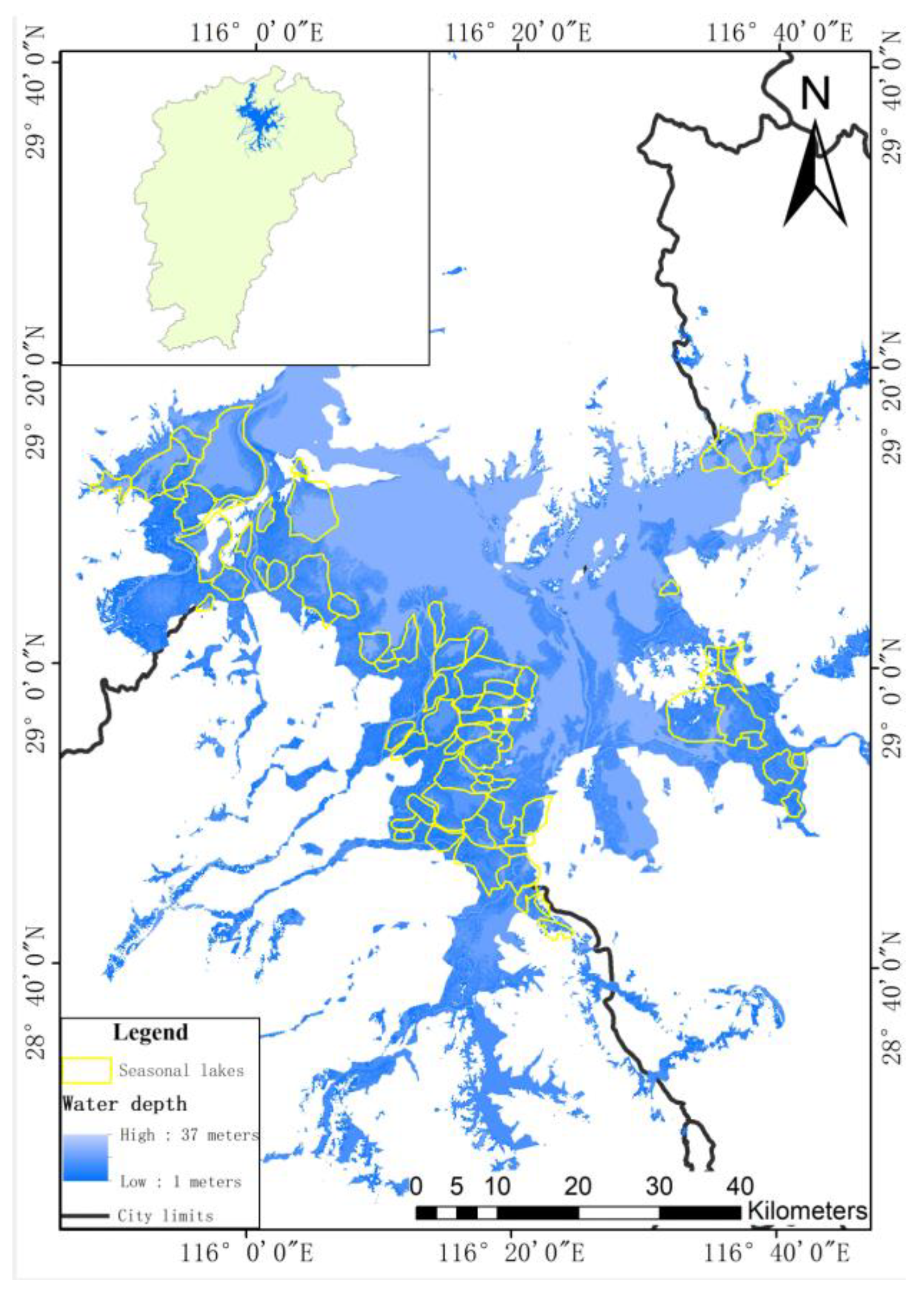
Poyang Lake (28°24′–29°46′ N, 115°49′–116°46′ E) is located in the northern part of Jiangxi Province, China. The seasonal lakes are mostly adjacent to the main lake and connected in patches; most are concentrated in the western part of the lake basin, which is also the location of the Poyang Lake National Protection Area and National Wetland Park [17]. The region has a subtropical warm, wet monsoon climate, with an average annual precipitation of 1358–1823 mm. The climate is mild, and the average annual temperature is 17.3°C. Poyang Lake has hydrological characteristics that cause the lake to resemble a lake at high water and a river at low water, and the water level drop in Poyang Lake is large each year. In the wet season, the seasonal lakes are connected with the main lake, but in the dry season, they are mostly separated from the main lake [18]. Based on the results of the basic geographic survey of Poyang Lake organized by the Jiangxi Provincial Government in 2010, this study selected 77 major seasonal lakes as the study area (Figure 1). Most of the area is located in the transitional zone of land and water, which is a wetland ecosystem that serves as a buffer zone against droughts and floods in Poyang Lake and the main activity area of spawning fish and migratory birds.
2.2. Data
From the geospatial data cloud platform (http://www.gscloud.cn/ accessed on 30 October 2020) and China Resource Satellite Application Center (http://www.cresda.com/site1/ accessed on 30 October 2020), 278 LandsatTM/ETM+/OLI images and 237 HJ-1A/B images were collected, with a total of 515 images (as shown in Table 1). These databases have the same spatial resolution and similar waveband settings, and they can be used to accurately obtain the spatial distribution information of the lakes.
The precipitation and evaporation data of Poyang Lake stations from 1973 to 2018 were obtained from the China National Meteorological Information Center (http://data.cma.cn/ (accessed on 30 October 2020)). The rainfall data came from the monthly data set of China’s surface climate data, with a total of 4416 items. Evaporation data came from the monthly data set of surface climate standard values from the China International Exchange Station, with a total of 48 items. These data were used to calculate the monthly average precipitation and evaporation in the Poyang Lake area and to calculate the water surplus and loss.
2.3. Research Methods
2.3.1. Water Body Information Extraction
The normalized differential water index (NDWI) is adopted for water information extraction. The combination of green bands and infrared bands in the NDWI can greatly suppress the influence of vegetation, terrain and mountain shadows, and the extraction is highly effective in shallow water and small water areas [19].
The specific formula is as follows [20]:
where Green represents the green light band and NIR represents the near-infrared band, which are the second and fourth bands of the Landsat and HJ satellites, respectively.
In the extraction process, based on the results of previous studies, image data were selected as a reference to visually identify the water extraction results and determine the appropriate threshold value.
2.3.2. Correlation Analysis
Bivariate correlation analysis was used to study the relationships among precipitation, average temperature and the water area of the seasonal lakes. The bivariate correlation analysis formula is as follows:
where rab is the correlation coefficient between variables a and b; ai and bi are the values of variables a and b in the i-th year, respectively; is the average value of variable a in the study period; is the average value of variable b in the study period; and n is the study period.
However, there are intensive interactions between each factor. When there are other variables that affect the results of correlation analysis, binary correlation analysis cannot be used to eliminate the mutual influence between the factors. However, partial correlation analysis measures the degree of linear correlation between two variables among multiple variables when the influence of other variables is controlled. Thus, this method can be used to effectively eliminate the influence of other variables, and it more reliably determines the internal linear relationship between two variables. Therefore, we used partial correlation analysis to calculate the relationship between the two variables. The partial correlation was calculated as follows:
where rab and c represent the partial correlation coefficient between variables a and b, respectively, when c is the control variable; rab, rac and rbc represent the simple correlation coefficient between variables a and b, a and c, and b and c, respectively; and the values of rab and c range from −1 to 1. When rab and c < 0, the variable ab is negatively correlated when c is the control variable; when rab and c > 0, the variable ab is positively correlated when c is the control variable.
3. Variation Characteristics of the Seasonal Lakes
3.1. Monthly Variation
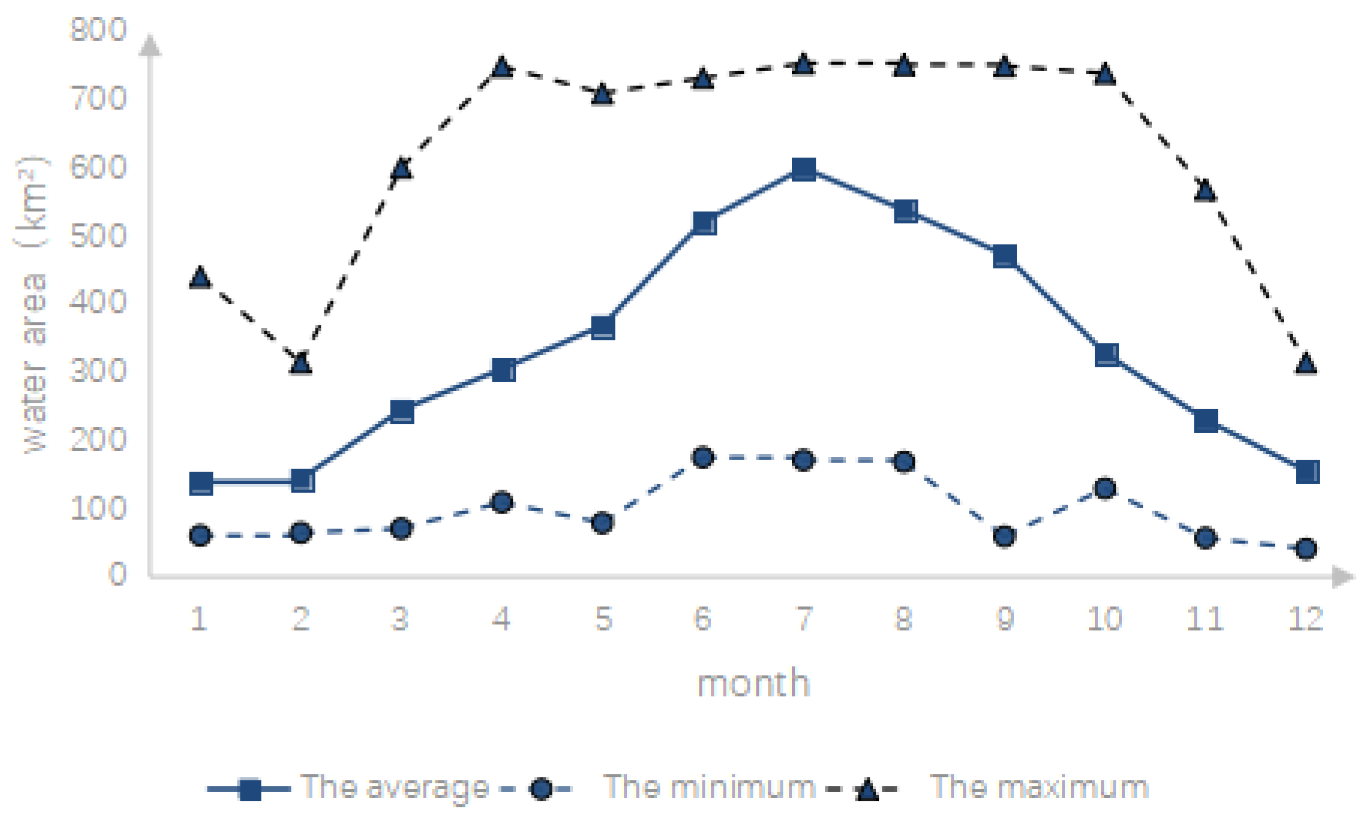
Based on the extracted water area of the seasonal lakes from 1975 to 2019, the maximum, minimum and average water areas of each month during the study period were calculated, and the curves are shown in Figure 2.
The figure shows that during the whole study period, the monthly average water area of the seasonal lakes fluctuated between 140 km² and 600 km², the maximum value of each month was greater than 300 km², and the minimum value was less than 200 km². The largest difference between the maximum value and the minimum value of each month typically occurred from April to May and from September to October, which both had differences greater than 600 km², and the smallest difference mainly occurred from January to February and in December, which had values less than 400 km².
The monthly mean water area of the seasonal lakes region showed a unimodal change during the year and showed an upward trend from January to July. The rate of increase was slow from January to March, but it was fast from March to July and reached the maximum value in July, exceeding 600 km². Then, it showed a downward trend, declined slowly from July to September, and continued to decline rapidly from September to December. The mean water area dropped below 200 km² in December, but it was still higher than that in January and February and lower than that in March.
3.2. Interannual Variation
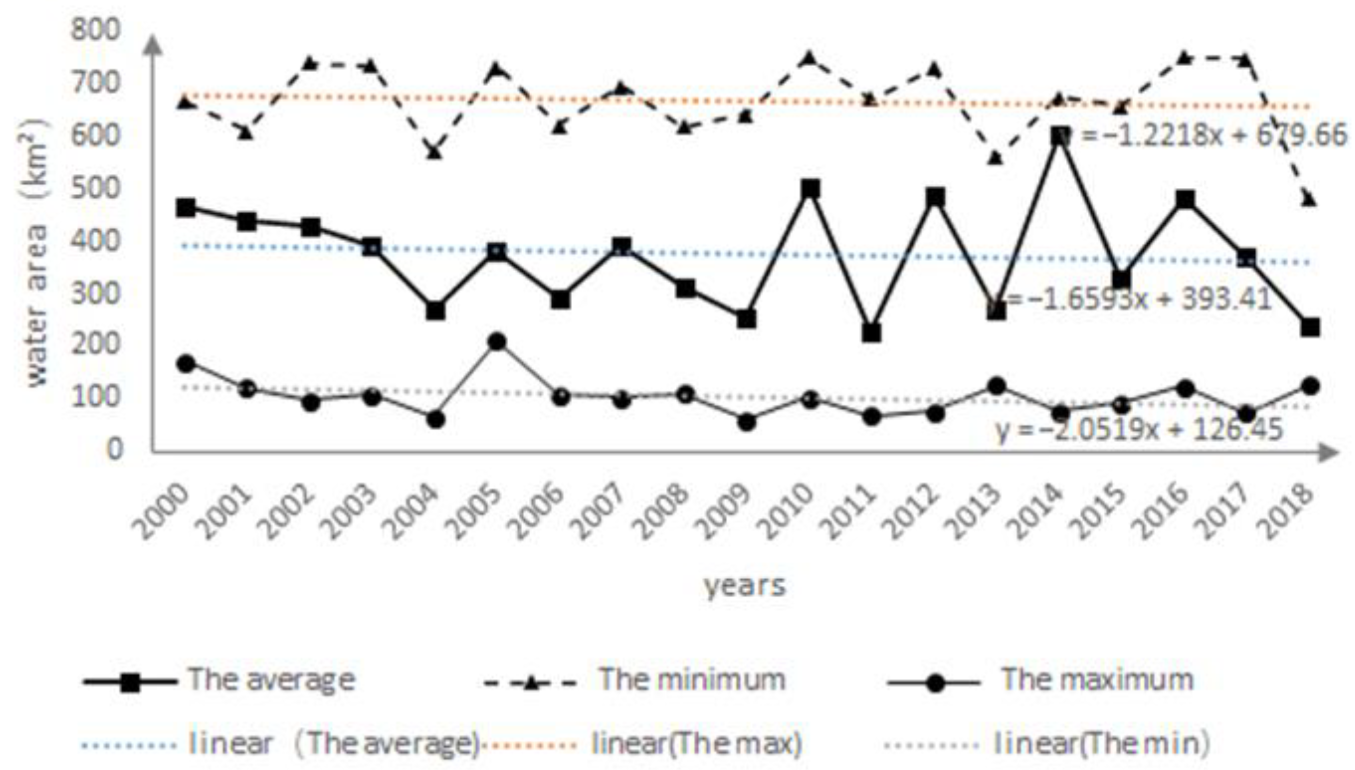
The average annual water area was calculated based on the monthly water area of the seasonal Lakes area (Figure 3). Considering that there were many data obtained after 2000 and the annual distribution was relatively balanced, the data change from 2000 to 2018 was used to analyze the change in water area over the study period. The maximum value and minimum value of the water area were used for comparison.
The results showed that the annual average, maximum and minimum water areas of the seasonal lakes fluctuated greatly in each year; the largest wave band was the annual mean water area, and the smallest was the annual minimum water area. The annual mean, maximum and minimum water areas all showed a slight decreasing trend, with the largest decreasing amplitude occurring in the minimum water area and the smallest in the maximum water area. The fluctuation range from 2000 to 2009 was smaller than that from 2010 to 2018. The annual average water area was identified in 2015, and the minimum value was identified in 2018, both of which appeared after 2010.
3.3. Spatial Change
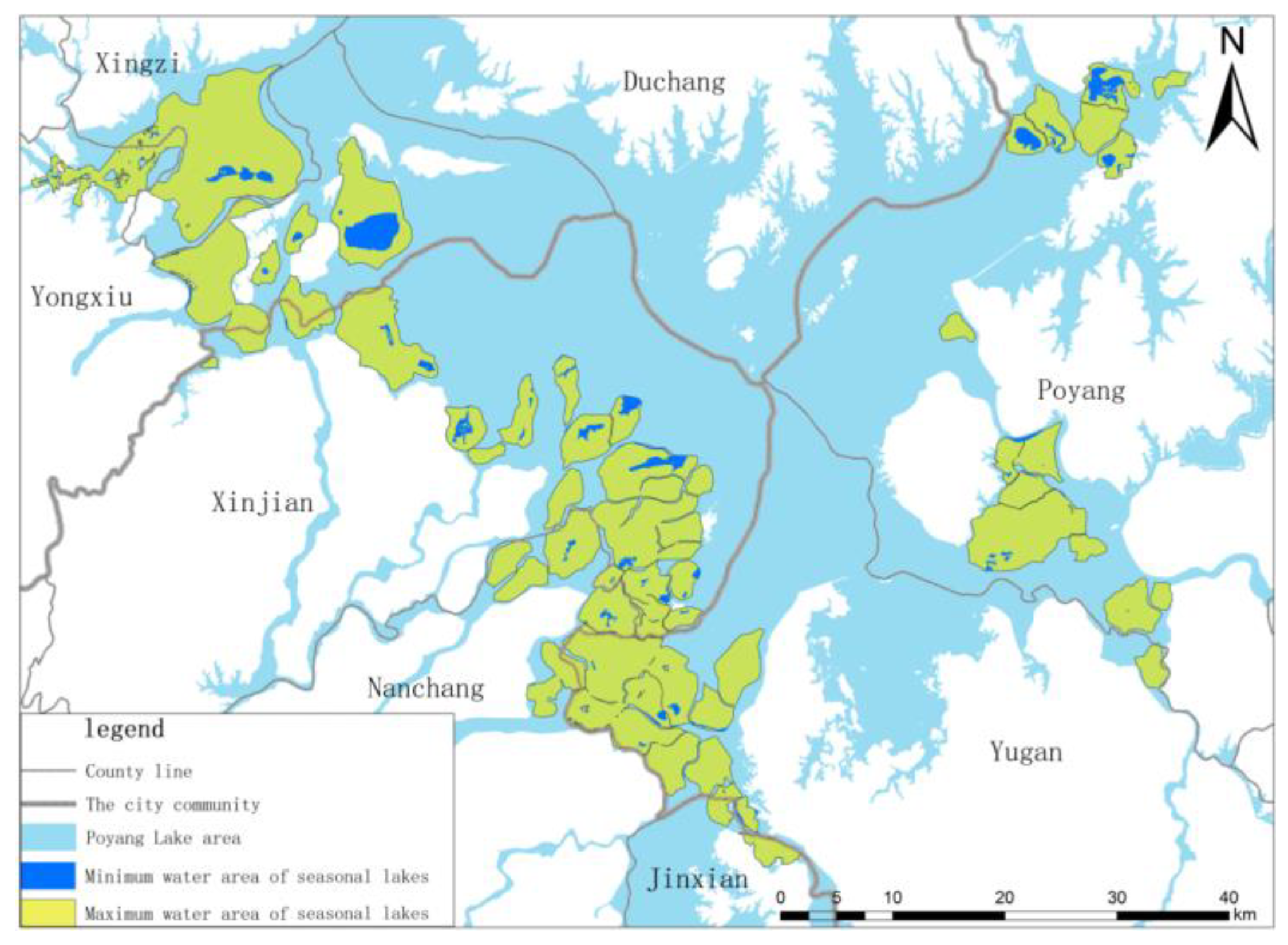
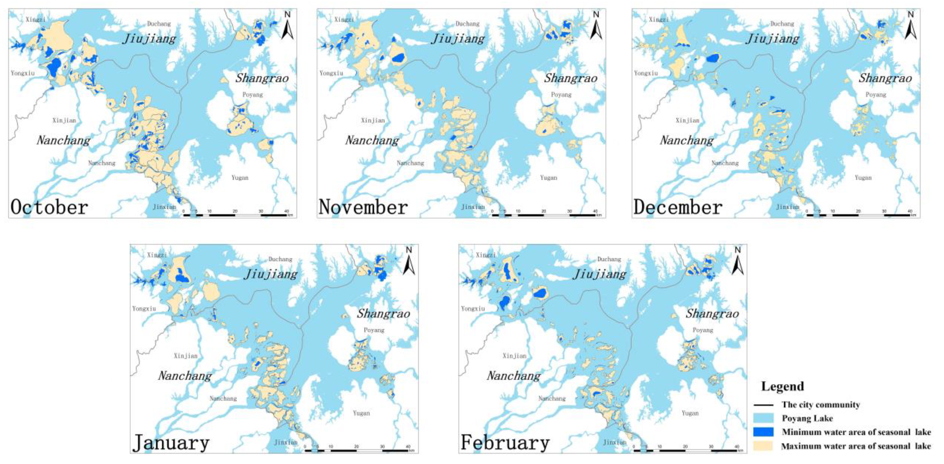
In the ecosystem of the Poyang Lake region, each seasonal lakes is a highly open and relatively independent subsystem with its own characteristics. Seasonal lakes are mainly distributed in the western Poyang Lake region, especially in the northwest and southwest, and in a small part of the eastern Poyang Lake region. When the area is the largest, the whole lake spills into the basin area, and when the area is the smallest, portions of the lake dry up. The water area changes greatly, and a spatial comparison chart of the water area change of the seasonal lakes is presented in Figure 4.
During the year, the area of the seasonal lakes change with the change in the area of Poyang Lake. During the wet season, the seasonal lakes and Poyang Lake are integrated; large amounts of material, energy and information are exchanged; and physical, chemical and biological effects occur. There are some commonalities between seasonal lakes and Poyang Lake at different elevations and positions. In the dry season, the bottom of the seasonal lakes is exposed. Under the action of sunlight and air, the soil and organisms at the bottom of the lake decompose the residual plants and reduce the toxic substances, which can improve the soil and prevent sedimentation and swamping [3]. After separation from the main lake area, the seasonal lakes is a relatively independent subsystem with its own unique water spatial changes. In the same year, its distribution has a certain regularity. Some fixed lakes experience water storage when shrinking. At the same time, there are large differences in seasonal water area in a single year, which contributes to habitat heterogeneity and enriches the biodiversity of the Poyang Lake ecosystem. The seasonal lakes area and Poyang Lake area are connected in the wet season, correlated in the normal season and separate in the dry season. That is, when the seasonal lakes area expands to its maximum value, the whole area merges into Poyang Lake. When the seasonal lakes area shrinks to its minimum value, most of the lakes will dry up, or there will be little water in the low-lying areas. Additionally, the evolution of the seasonal lakes is still slow, showing an alternating process of erosion and deposition. Furthermore, the evolution of the lakes changes with the area of Poyang Lake every year.
The spatial distribution of interlunar and interannual waters needs to be analyzed in combination with the situation of each lake. This paper only makes preliminary inferences and divides the seasonal lakes region into four regions: the spatial distribution of seasonal lakes in the northwest and northeast regions is relatively stable, while the spatial distribution of seasonal lakes in the southwest and southeast regions changes greatly.
4. Influencing Factors of the Change in the Seasonal Lakes
4.1. Natural Factors
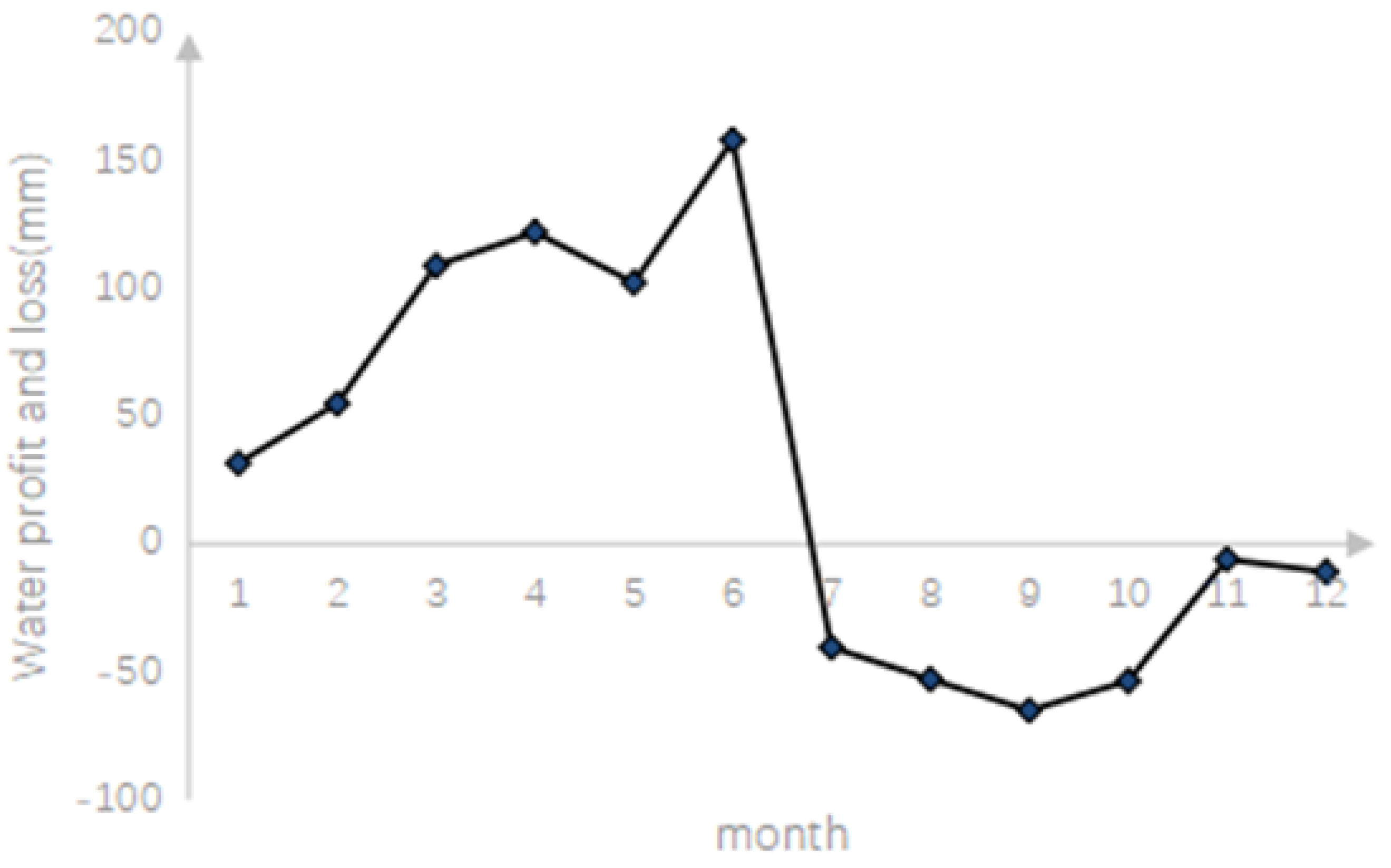
The monthly average precipitation, evaporation, and temperature in the Poyang Lake area were calculated, and the water deficit was determined (Figure 5).
The curve shows that in response to climate factors, the water surplus and deficit of Poyang Lake mainly increased in the first half of the year and decreased in the second half of the year; additionally, the maximum surplus appeared in June, which was basically the same as the change trend of the seasonal lakes area. The seasonal lakes had the largest water area in July, which is when the evaporation is greater than the rainfall. This difference occurs because the Five Rivers and the Yangtze River reach their high water levels during heavy rainfall conditions from April to June. Poyang Lake is a water-storing lake and receives more water during this time. As a result, the area increases, and the seasonal lakes expand further. Therefore, when the seasonal lakes are connected to Poyang Lake, the water area is also affected by the amount of water entering the lake.
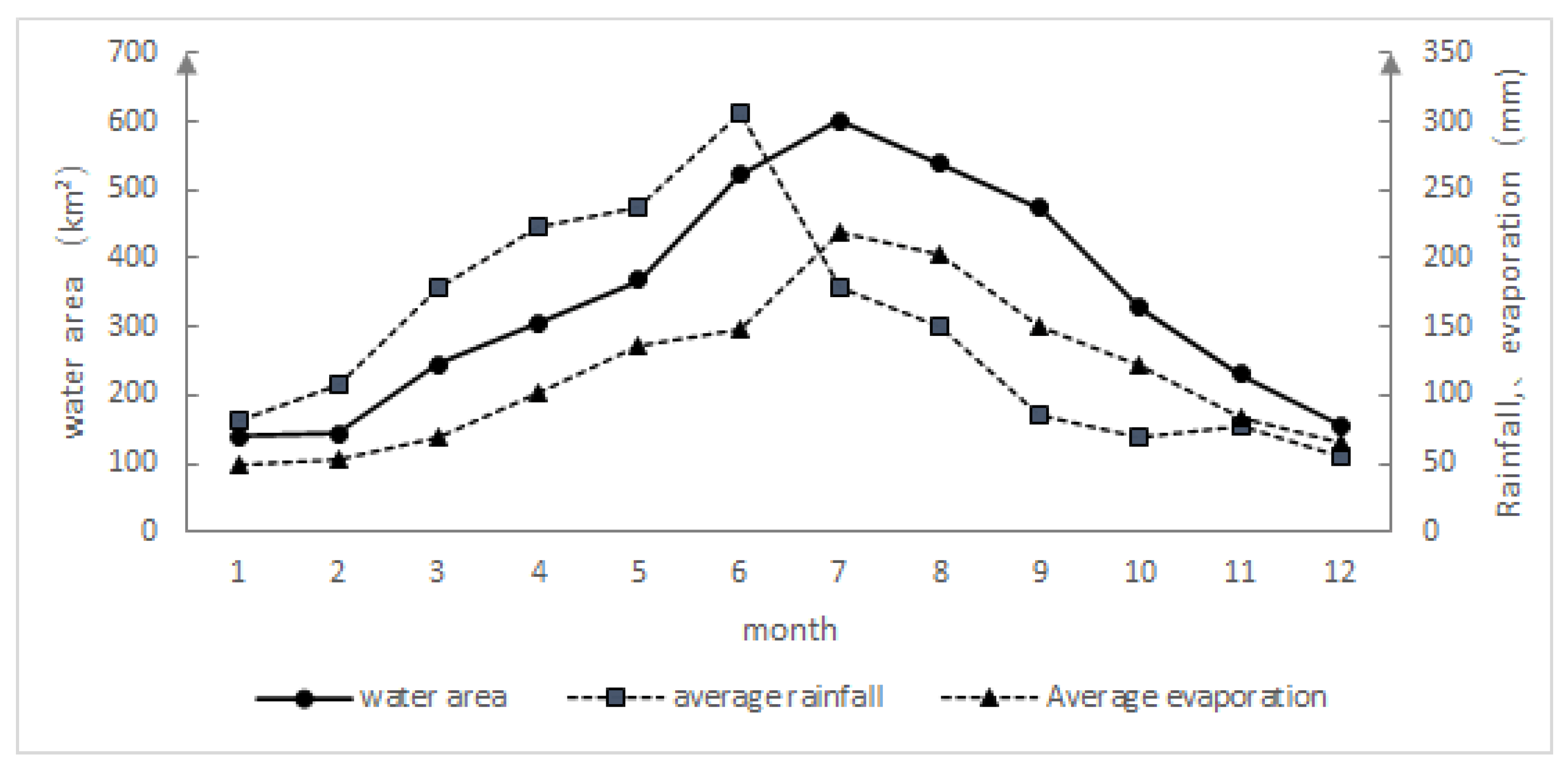
Figure 6 shows that there is a great difference in monthly rainfall in the Poyang Lake region. The maximum rainfall is 306.08 mm in June and only 54.35 mm in December, a nearly six-fold difference. The maximum evaporation is 203.37 mm in August, and the minimum evaporation is 49.11 mm in January.
The simple correlation analysis showed that the water area of the seasonal lakes and the evaporation and temperature were all within the 99% confidence interval, and there was a significant correlation. The correlation coefficients were 0.969 and 0.980, respectively. The area was correlated with the amount of rainfall in the 90% confidence interval, and the correlation coefficient was 0.507, which was relatively low. These results were obtained because rainfall is mainly distributed from April to August, while evaporation and temperature are greatest from April to October; thus, evaporation and temperature have a longer impact on the water area of the seasonal lakes. In addition, the area of the seasonal lakes gradually increased. The area increases and becomes so large that it is integrated with the main lake, and the impact of rainfall on the water area is reduced. When the seasonal lakes are independent of the main lake area, evaporation and temperature have a greater impact on the small lake wetlands. The line graph (Figure 6) clearly illustrates this correlation.
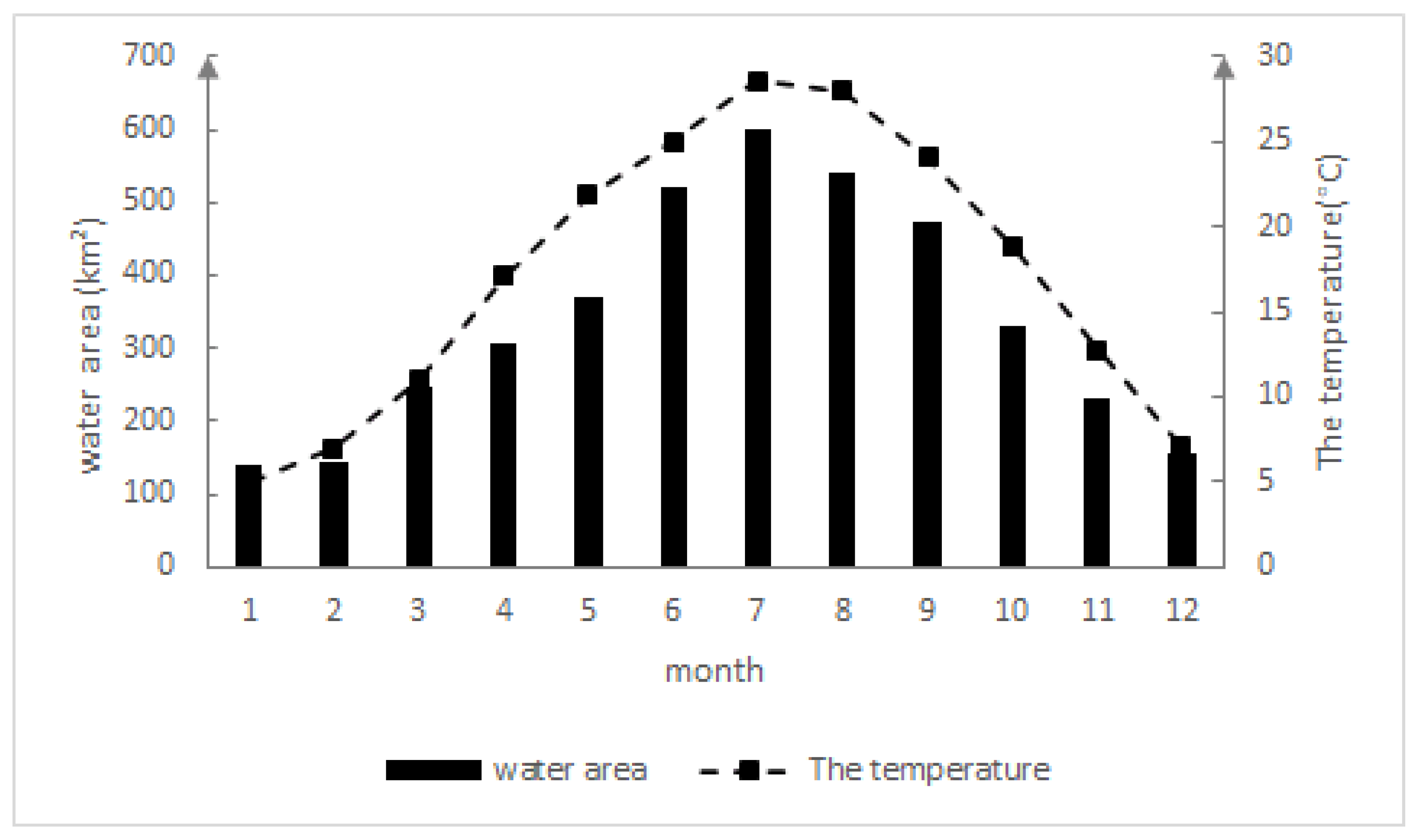
Since the correlation coefficient between temperature and evaporation was 0.966 and the correlation significance was greater than 0.99, there was a significant correlation; thus, partial correlation analysis was carried out on the basis of simple correlation analysis.
The analysis showed that when temperature was the control variable, the water area of the seasonal lakes and the evaporation were within the 90% confidence interval, and there was a significant correlation, with a correlation coefficient of 0.44. Additionally, when evaporation was the control variable, the water area of the seasonal lakes and the temperature were within the 99% confidence interval, the correlation was significant, and the correlation coefficient was 0.678. The correlation between the water area of the seasonal lakes and the temperature was greater, and temperature was the most important factor affecting the change in the water area of the seasonal lakes. The comparison chart of monthly average temperature and water area (Figure 7) shows that the trends of the two are basically the same.
Poyang Lake is a typical river-connecting lake in the middle reaches of the Yangtze River. Due to the different seasonal variation characteristics of precipitation in the middle and upper reaches of the Yangtze River and the Poyang Lake basin, the intensity of water exchange between the Yangtze River and Poyang Lake varies with the seasons, and the two affect each other, leading to seasonal changes in the water level and discharge of the river and lake [21]. When the water levels of both the river and the lake are high, the flood probability of Poyang Lake increases, and the seasonal lakes are connected to the main lake. When the water levels of both the river and the lake are low, Poyang Lake experiences an increased drought effect, and the area of the seasonal lakes decreases. April to June is the season with the maximum precipitation in the Poyang Lake basin, and this is also when the maximum increase in the total discharge from the Five Rivers into the lake occurs. Poyang Lake plays a strong role. However, July to September is the season with higher precipitation in the middle and upper reaches of the Yangtze River and when the maximum runoff in the main stream of the Yangtze River occurs. The water of Yangtze River is used for irrigation during this time.
4.2. Human Factors
4.2.1. Influence of “Enclosing Sublakes in Autumn”
The main human factor affecting the seasonal lakes is called the “enclosing sublakes in autumn” fishing operation. The “enclosing sublakes in autumn” approach is a traditional fishery production method with seasonal artificial water level control, and it is used near large lakes in the middle and lower reaches of the Yangtze River. According to the characteristics of the formation of more seasonal lakes in the delta of the estuary of the lake, an embankment is artificially constructed for seasonal artificial production. The water level is adjusted so that part of the lake water is intercepted by the seasonal lakes during the dry season, and the fishing operation is carried out after the water is released through a sluice in autumn [22]. In January, the water levels of the seasonal lakes and the main lake area begin to rise slowly, and from February to May, the water area of Poyang Lake increases rapidly. At this time, the seasonal lakes are independent of the main lake area, so the water area of the seasonal lakes does not change greatly. Later, the seasonal lakes and Poyang Lake are connected, and the water area of both sides shows an increasing trend until they reach peak values in July. From July to September, Poyang Lake enters a retreat period, and the seasonal lakes area begins to decline with the decrease in the area of the main lake. The main lake area has a relatively high rate of decline, while the seasonal lakes decline slowly due to the interception of the embankment, and the seasonal lakes gradually become separated from the main lake area again. By October, the seasonal lakes area is fished with the “enclosing sublakes in autumn” method. A large amount of water is released from the sluices on the seasonal lakes, and the area rapidly declines. When the water level of the main lake area increases to the height of the embankment in the coming year, the water level of the seasonal lakes rises, the water area increases, and they become connected to the main lake area again (Figure 8).
Therefore, human activities have intensified the change in the water level in seasonal lakes, making the hydrological characteristics of seasonal lakes significantly different from those of the main lake near the embankment of Poyang Lake. The main reason is that in the dry season, compared with the beach area outside the dike, the seasonal lakes area within the dike experiences a longer flooding time. This artificial regulation also makes seasonal lake areas an important wetland resource rich in fish and beach plant communities. For a long time, most of the seasonal lakes located upstream of the flood area were equipped with independent sluice gates to meet the demand of fish culture in the seasonal lakes during the low water level period by closing the gates for water storage [22]. The interference of human activities has affected the fishing time and intensity of the “enclosing sublakes in autumn” fishing method. The period of “enclosing sublakes in autumn” is increasingly earlier, and drainage fishing is more thorough [7]. As a result, the water area of the seasonal lakes shrinks earlier, and the water area is smaller in the dry season. In addition, this change has led to the depletion of fishery resources and the shrinking of average fish size in Poyang Lake. Since the turn of the 21st century, to protect the fishery resources in the Poyang Lake region and considering the sustainable development of the regional ecological environment and social economy, the Jiangxi provincial government has issued a series of laws and regulations, among which the fishing method of “enclosing sublakes in autumn” has been explicitly prohibited [23]. To a certain extent, the fishery resources and ecological environment of Poyang Lake have been protected and restored, and the influence of human factors on the change in seasonal lakes water area has been reduced.
4.2.2. Influence of the Three Gorges Reservoir
The influence of the Three Gorges Reservoir on the annual runoff of the Yangtze River is not obvious. However, the reservoir contributes to the influence of human factors on the seasonal variation in the runoff of the Yangtze River. Thus, the reservoir affects the seasonal variation in the water level and volume of Poyang Lake. Water storage or discharge in different seasons has affected the probability of drought and flooding in the Poyang Lake basin. The release of water from April to June coincides with the rainy season in the Poyang Lake basin, which may increase the probability of flooding in the Poyang Lake basin in early summer. A small amount of water storage from July to September reduces the probability of flooding in the lake area. However, the massive impoundment of the Three Gorges Reservoir in October may increase the incidence of drought in the Poyang Lake Basin during the dry season. After the Three Gorges Reservoir began operating, the hydrological rhythm of the lake area changed significantly, the water level in the flood stage was higher, the water level in the retreat stage was lower, the fluctuation speed was accelerated, the occurrence time of the dry period was earlier, the dry period duration was longer, and the hydrological rhythm in the lake area changed into a cycle of floods and droughts. Additionally, since most of the seasonal lakes are located in the fluctuation zone of Poyang Lake, the changes in water level and quantity directly affect the change in the seasonal lakes area.
5. Ecological Impacts of Changes in the Seasonal Lakes
5.1. Impact on Wetland Vegetation
Wetland vegetation is the most basic component and primary producer of wetland ecosystems, and the community distribution and species diversity of wetland vegetation have a great influence on the stability of wetland ecosystems [24,25]. The change in water area directly affects whether a region will be flooded and is an important factor affecting vegetation growth and development. There are many seasonal lakes in the Poyang Lake region. Due to their unique silt beaches and the processes involved in periodic water area, the soils are saturated in lake water, and these lakes proved to have favorable conditions for the growth of wetland vegetation. The grassland area of the seasonal lakes region is approximately 500 km², accounting for 23% of the entire Poyang Lake region [26,27]. However, the drastic change in water area will not only change the hydrochemical process of lakes [28,29], but also affect the growth and distribution of wetland organisms in the region, leading to dynamic changes in wetland types.
Affected by the seasonal variation in the hydrological rhythm of Poyang Lake, the wetlands in the seasonal lakes region show a typical water-land alternation. From January to March, there is less rainfall in the region, and the water levels of the seasonal lakes are relatively stable, maintaining the characteristics of a shallow lake. These characteristics provide superior environmental conditions for the development of wetland perennial plants. The flood season starts from April to June, the beaches begin to flood, emergent plants enter the flood period, and aquatic plants begin to sprout and grow. From June to August, the seasonal lakes area is connected to the main lake area, and the water area is large. With the lake as the main body, the vegetation coverage and biomass gradually increase. In September, the water areas of the seasonal lakes begin to decrease, and the flood depth gradually decreases. Aquatic plants begin to grow and develop and quickly complete their life history. By October, the water from seasonal lakes is artificially drawn down for fishing, the water level drops, and the water area gradually decreases. The seasonal lakes are separated from the main lake area, and wet vegetation appears. In November, the biomass of the wet vegetation community on the beaches reaches its maximum level, and the vegetation life history cycle is gradually completed. After December, as the water area continues to shrink, most of the wet plants become dormant or wither, and parts of the seasonal lakes dry up. At this time, the bottom of the lake is exposed to the sun, and the remains of aquatic plants are completely decomposed, thus preventing the marshification of seasonal lakes and protecting the wetland ecosystems of seasonal lakes [30]. Therefore, the hydrological conditions in April and September are critical periods for the normal growth of wet and aquatic plants.
The growth of aquatic vegetation in the seasonal lakes wetland in different seasons also shows certain patterns. According to the different seasons, vegetation coverage is greatest in summer, followed by autumn, and then in spring, and the NDVI in summer is significantly higher than that in the other three seasons. The NDVI value of vegetation ranged from 0.72–0.79, followed by that of autumn, which fluctuated from 0.59–0.69. The NDVI value of vegetation in spring fluctuated from 0.55–0.64, and the NDVI value of winter was the lowest, ranging from 0.49–0.57 [31]. In spring, the weak vegetation coverage was due to the influence of the temperature and precipitation in the previous winter, which caused the surrounding areas of the lake to dry up and the vegetation to become degraded. The vegetation coverage is the highest in summer because the Poyang Lake basin is located in the humid monsoon region in the eastern part of China. In summer, the temperature is high and rainy, and the vegetation growth period is from April to October. In the growing season, the vegetation coverage is the highest, while in autumn, the vegetation coverage is second only to that summer due to the reduced precipitation and lower temperature.
Seasonal lakes are of great importance in the wetland ecosystem of Poyang Lake, and the wetland ecological process has corresponding feedbacks on the hydrological process of the seasonal lakes. Widely distributed seasonal lakes with different depths play a role in transitioning and buffering the process of substantial water level changes in Poyang Lake, maintaining the stability of the system, effectively alleviating the impact of seasonal drought and flood disasters in the main lake area on the wetland ecosystem of Poyang Lake, and becoming the key focus for biodiversity conservation and wetland vegetation development in the Poyang Lake wetland [32,33,34,35]. These lakes play an important role in maintaining the integrity of the global ecosystem.
5.2. Impact on the Number of Migratory Birds
Wetlands are sometimes known as a “Bird Paradise”. More than 80% of the area of the Poyang Lake National Nature Reserve is composed of seasonal lakes. The seasonal lakes wetland has a vast area and provides a good habitat for migratory birds to overwinter. The plant community in the wetland is complex and diverse, attracting the reproduction and migration of migratory birds and wintering waterbirds [36]. In recent years, Poyang Lake has experienced continuous dry years with continuous dry seasons in autumn and winter, prolonged dry seasons and low water levels. Due to the existence of seasonal lakes, the number of overwintering migratory birds has not changed significantly, and more than 80% of the overwintering migratory birds in the lake overwinter in the seasonal lakes area [37]. Thus, seasonal lakes play a unique and important role in maintaining the integrity and species diversity of the Poyang Lake wetland ecosystem, making it an indispensable and important area for migratory birds to migrate and complete their life history in East Asia [37].
Generally, the habitat environment for overwintering migratory birds is composed of broad shallow-water areas and wide mudflat swamp zones (Figure 9). These habitats exist only in lakes in which the water in the seasonal lakes does not completely disappear at its lowest level and where, at the highest water level, the water does not completely submerge the surrounding wetlands. Additionally, lakes with infrequent human activities are suitable for migratory birds to overwinter. In October every year, the water area of the seasonal lakes gradually decreases, exposing the beach and lake bottom. With changes in water level and area, a new mudflat and land-water alternating zone is formed, which provides wintering migratory birds with shallow water levels and good habitat. At this time, winter birds, mainly waterfowl, begin to move in, and their numbers increase steadily. In December, the number of migratory birds reaches its peak. In this study, from October to December, there was a negative correlation between the water area and the number of migratory birds; that is, with the decrease in water area, the number of migratory birds increased. When the water area of the seasonal lakes continued to decrease and reached its minimum in January, some seasonal lakes dried up, resulting in a decrease in aquatic vegetation and plankton and a reduction in the effective foraging range of water birds. Overwintering migratory birds then migrated to other areas. In February, the rainfall increased relatively. The seasonal lakes, which had been exposed to mud flats at the bottom of the lake, began to accumulate water. The plant residues and insect eggs in the lake began to recover and sprout, providing a good habitat and foraging location for migratory birds and attracting a large number of migratory birds to return. After March, the climate became warmer, and the wintering birds migrated to other areas in succession [13]. At this time, the amount of water in the seasonal lakes area began to increase notably, the water area expanded, and the beaches decreased, which affected the development of the surrounding vegetation and further affected the reduction in the number of overwintering migratory birds. Therefore, the change in water area is a key factor affecting the species and quantity of overwintering migratory birds.
Combined with the monthly variation characteristics of the water area of the seasonal lakes, it can be concluded that the total water area of the seasonal lakes in the suitable period for migratory birds is between 200 km² and 300 km² (Figure 10). A large area of water will lead to a reduction in mudflats and meadows and other habitats, while a small area of water will lead to insufficient food sources. Therefore, for the protection of overwintering migratory birds, it is necessary to balance the areas of water and mudflats to ensure adequate prey and habitat resources. To maintain the biodiversity of Poyang Lake, scientific water level management is needed to ensure that water birds can continue to forage in seasonal lakes. Due to the different jurisdictions and utilization purposes of different seasonal lakes, there are differences in water quantity control methods during the wintering period, which affect the species and quantity of water bird foraging and roosting in seasonal lakes. In the case of drought and high temperatures in winter in the Poyang Lake region, the water in the seasonal lakes evaporates rapidly after water is released, and these conditions make it difficult for rare birds, such as white cranes, to inhabit the area. If water is not released, the water area will remain unchanged, and wetland vegetation will not develop, which will also affect the number of migratory birds. Water area is an important factor that affects the use of wetland habitat by waterbirds. It is suggested that a specific winter water control scheme should be developed for each seasonal lakes to meet the overwintering needs of waterbirds.
6. Conclusions
Based on long time-series remote sensing data, this paper extracted the water area information in the seasonal lakes of Poyang Lake, analyzed the monthly and annual time scales and the spatial water area change characteristics, and then analyzed the influencing factors of changes in the seasonal lakes water area, including natural and human factors. Finally, the ecological impact of changes in the seasonal lakes water area was analyzed in terms of wetland vegetation and the number of migratory birds.
The results showed that the average water area of the seasonal lakes showed a unimodal change over the year, with an upward trend from January to July, a peak in July, and a decreasing trend from July to January of the next year. The interannual variation in water area fluctuated greatly in the last ten years, and the overall water area showed a slight downward trend. In terms of spatial changes, the seasonal lakes were integrated with the main lake area during the high water period and separated from the main lake area during the dry period. Compared with the lake groups in the southwest and southeast regions, the water distribution in the northwest and northeast regions was relatively stable, and the water distribution in the southwest changed the most.
Among the natural factors, the influences of temperature, evaporation, and rainfall on the water area of the seasonal lakes were successively reduced. In addition, the incoming water from the Yangtze River had an important influence. Among the human factors, the traditional fishing method called “Enclosing sublakes in Autumn” had the greatest impact on the changes in the water area of the seasonal lakes in a specific period, followed by the indirect impact of the Three Gorges Project.
In seasonal lakes, the cyclical change in water area is an important factor affecting the growth and development of vegetation. Seasonal lakes have a vast wetland area and are a good habitat for migratory birds to overwinter. The number of wintering waterbirds is the largest from October to February, when the water area is 200-300 km².
Author Contributions
The authors undertook different tasks for this paper. H.L. designed the research and revised the paper. H.Y. and S.W. analyzed the data. L.Z. wrote the paper. M.L. provided direction to the research work. All authors have read and agreed to the published version of the manuscript.
Funding
This research was financially supported by National Key Research and Development Program of China (2018YFC1506500) and National Natural Science Foundation of China (41971402).
Institutional Review Board Statement
Not applicable.
Informed Consent Statement
Not applicable.
Data Availability Statement
Data developed in this study will be made available on request to the corresponding authors.
Conflicts of Interest
The authors declare no conflict of interest. The funders had no role in the design of the study; in the collection, analyses, or interpretation of data; in the writing of the manuscript, or in the decision to publish the results.
References
- Ronbinson, S.J.; Souter, N.J.; Bean, N.G.; Ross, J.V.; Thompson, R.M.; Bjornsson, K.T. Statistical description of wetland hydrological connectivity to the River Murray in South Australia under both natural and regulated conditions. J. Hydrol. 2015, 531, 929–939. [Google Scholar] [CrossRef]
- Funk, A.; Martínez-López, J.; Borgwardt, F.; Trauner, D.; Bagstad, K.J.; Balbi, S.; Magrach, A.; Villa, F.; Hein, T. Identifification of conservation and restoration priority areas in the Danube River based on the multi-functionality of river-flfloodplain systems. Sci. Total Environ. 2019, 654, 763–777. [Google Scholar] [CrossRef] [PubMed]
- Hu, Z.; Zhang, Z.; Liu, Y.; Ji, W.; Ge, G. The function and signifificance of the Shallow-Lakes in the Poyang Lake wetland ecosystem. Jiangxi Hydraul. Sci. Technol. 2015, 41, 317–323. (In Chinese) [Google Scholar]
- Evenson, G.R.; Golden, H.E.; Lane, C.R.; D’Amico, E. Geographically isolated wetlands and watershed hydrology: A modifified model analysis. J. Hydrol. 2015, 529, 240–256. [Google Scholar] [CrossRef] [Green Version]
- Li, Y.; Zhang, Q.; Liu, X.; Tan, Z.; Yao, J. The role of a seasonal lake groups in the complex Poyang Lake-floodplain system (China): Insights into hydrological behaviors. J. Hydrol. 2019, 578, 124055. [Google Scholar] [CrossRef]
- Xie, D.M.; Jin, G.H. Riparian landscape change in Poyang Lake. Acta Ecol. Sin. 2016, 36, 5548–5555. [Google Scholar]
- Qi, S.H.; Liu, Y.; Yu, X.B.; Liao, F.Q. Effect of “Lake Enclosed in Autumn” on The Habitat of Winter Bird In Poyang Lake. Resour. Environ. Yangtze Basin 2011, 1, 18–21. [Google Scholar]
- Ji, W. Poyang Lake: Bathymetry, Hydrology and Vegetation; Science Press: Beijing, China, 2017; pp. 49–53. [Google Scholar]
- Li, H.; Li, C.A.; Zhang, L.H.; Tian, L.J. Relationship between water leveland water area in Poyang lake based on Modis image. Quat. Sci. 2008, 28, 332–337. [Google Scholar]
- Min, Q.; Zhan, N.S. Characteristics of low—Water level changes in Lake Poyang during 1952—2011. J. Lake Sci. 2012, 24, 675–678. [Google Scholar]
- Zhang, P.; Lu, J.Z.; Chen, X.L.; Tian, L.Q. Hydrodynamic Simulation of Water Extend Change in Poyang Lake with Aid of MODIS Remote Sensing Data. Geomat. Inf. Sci. Wuhan Univ. 2012, 37, 1087–1091. [Google Scholar]
- Zhan, F.P.; Fang, S.W.; Zhou, Z.H.; Wen, T.F.; Zhang, M.H. Research on multi-time-scale dynamic characteristics of water-level fluctuation of the Poyang lake in china. Resour. Environ. Yangtze Basin 2017, 26, 126–133. [Google Scholar]
- Li, H.H. Changes of Water Level in Main Lake Area of Poyang Lake and in Dish-shaped Sub-lake and Their Impacts on Water Quality. Resour. Environ. Yangtze Basin 2018, 27, 1298–1306. [Google Scholar]
- Zhang, G.S.; Yu, X.B.; Liu, Y.; Zhang, H.; Zhang, Q.J.; Li, Y.; Duan, H.L. Accumulation effect of litter decomposition and water level on carbon and nitrogen in shallow lake water of Lake Poyang. J. Lake Sci. 2018, 30, 668–679. [Google Scholar]
- Guo, H.C.; Hu, B.H.; Li, Q. Effects of autumn fishery by enclosing plate-shaped lake on the winter migratory birds and conservation strategies in Nanji wetland national natural reserve of the Poyang lake, Jiangxi. Resour. Environ. Yangtze Basin 2014, 23, 46–52. [Google Scholar]
- Zhang, X.C.; Qin, H.M.; Jin, B.S. Distribution in winter buds of submerged macrophyte and their contribution for herbivorous waterfowl in a shallow dish lake of Poyang Lake. Acta Ecol. Sin. 2014, 34, 6589–6596. [Google Scholar]
- Jian, M.F.; Li, L.Y. Distribution pattern of submerged plants in typical wetlands of Poyang Lake and its influencing factors of water environment. Resour. Environ. Yangtze Basin 2015, 24, 765–772. [Google Scholar]
- Dai, X.; Wan, R.R.; Yang, G.S. Non-stationary water-level fluctuation in China’s Poyang Lake and its interactions with Yangtze River. J. Geogr. Sci. 2015, 25, 274–288. [Google Scholar] [CrossRef] [Green Version]
- Cheng, L.; Xu, Z.X.; Zuo, D.P. Identification of water bodies in the loess plateau based on Landsat tm dataset. J. Beijing Norm. Univ. Nat. Sci. 2010, 46, 424–430. [Google Scholar]
- Mcfeeters, S.K. The use of Normalized Difference Water Index (NDWI) in the delineation of open water features. Int. J. Remote Sens. 1996, 17, 1425–1432. [Google Scholar] [CrossRef]
- Guo, H.; Hu, Q.; Zhang, Q. Changes in Hydrological Interactions of the Yangtze River and the Poyang Lake in China during 1957–2008. Acta Geogr. Sin. 2011, 66, 609–618. [Google Scholar]
- Zeng, Z.G.; Zhang, X.C.; Liu, G.H. Structure and Features of Fishery Resources of Sub-lakes in Poyang Lake, Jiangxi, China. Resour. Environ. Yangtze Basin 2015, 24, 1021–1029. [Google Scholar]
- Hu, M.L.; Wu, Z.Q.; Zhou, H.M. The fisheries characters and resource status of Nanjishan natural reserve in Poyang Lake. Resour. Environ. Yangtze Basin 2005, 14, 561–565. [Google Scholar]
- Wang, Y.L. Diversity of Vascular Plants in Cuihu Wetland in Beijing and Its Conservation. Wetl. Sci. Manag. 2012, 8, 26–28. [Google Scholar]
- Wu, Q.L.; Xia, X.L.; Ye, J. Plant diversity and ecosystem health assessment of Sanyang wetland in Wenzhou, Zhejiang. J. Zhejiang Univ. Agric. Life Sci. 2012, 38, 421–428. [Google Scholar]
- Huang, J.G.; Guo, Z.Y. The Wetland Biodiversity and Its Conservation Countermeasures in the Poyang Lake. Res. Soil Water Conserv. 2007, 1, 305–306. [Google Scholar]
- Li, R.D.; Liu, J.Y. An Estimation of Wetland Vegetation Biomass in the Poyang Lake Using Landsat ETM Data. Acta Geogr. Sin. 2001, 5, 531–539. [Google Scholar]
- Ye, C.; Liu, Y.B.; Zhao, X.S. Analysis of Poyang Lake wetland vegetation growth dynamics and its response to lake water level based on MODIS. Resour. Environ. Yangtze Basin 2013, 22, 705–712. [Google Scholar]
- Luo, W.; Zhang, X.; Deng, Z.M. Variation of the total runoff into Poyang Lake and drought-flood abrupt alternation during the past 50 years. J. Basic Sci. Eng. 2013, 21, 845–856. [Google Scholar]
- Tan, Y.J.; Yu, Y.Z.; Ding, J.N.; Tan, H.R. Control effects of Lake Poyang hydrological process on the wetland biology. J. Lake Sci. 2015, 27, 997–1003. [Google Scholar]
- Zhang, M. Spatio-Temporal Changes of Vegetation and its Driving Factors Covered in Poyang Lake; Jiangxi Normal University: Nanchang, China, 2018. [Google Scholar]
- Huang, W.; Wang, W.D. Effects of three gorges dam project on Dongting lake wetlands. Acta Ecol. Sin. 2016, 36, 6345–6352. [Google Scholar]
- Zhao, Q.G.; Huang, G.Q.; Qian, H.Y. Ecological environment and sustainable development of Poyang lake. Acta Pedol. Sin. 2007, 44, 318–326. [Google Scholar]
- Yan, E.R.; Wang, X.H.; Zhou, W. N:P stoichiometry in secondary succession in evergreen broad-leaved forest, Tiantong, East China. J. Plant Ecol. 2008, 32, 13–22. [Google Scholar]
- Lost, S.; Landgraf, D.; Makeschin, F. Chemical soil properties of reclaimed marsh soil from Zhejiang Province, P. R. China. Geoderma 2007, 142, 245–250. [Google Scholar]
- Wu, Y.H.; Ji, W.T. Study on Poyang Lake National Nature Reserve in Jiangxi Province; Beijing China Forestry Publishing House: Beijing, China, 2002. [Google Scholar]
- Hu, Z.P.; Ge, G.; Liu, C.L. Response of Wintering Migratory Birds to Hydrological Processes in Poyang Lake. J. Nat. Resour. 2014, 29, 1770–1779. [Google Scholar]
Figure 1.
The seasonal lakes in the Poyang Lake region.

Figure 2.
Lunar surface area curve of seasonal lakes area.

Figure 3.
Interannual water area change curve of the seasonal lakes.

Figure 4.
Comparison of spatial changes of the seasonal lakes.

Figure 5.
Water surplus and deficit curve of the Poyang Lake region.

Figure 6.
Comparison of monthly changes in rainfall evaporation and the water area of the seasonal lakes.
Figure 6.
Comparison of monthly changes in rainfall evaporation and the water area of the seasonal lakes.

Figure 7.
Comparison of monthly changes in temperature and the water area of the seasonal lakes.

Figure 8.
Comparison of changes in water area between seasonal lakes and Poyang Lake.

Figure 9.
Variation in the maximum and minimum areas of seasonal lakes during the migration of migratory birds.
Figure 9.
Variation in the maximum and minimum areas of seasonal lakes during the migration of migratory birds.

Figure 10.
The distribution of migratory birds in seasonal lakes.


Table 1.
Monthly available data.
| Month | 1 | 2 | 3 | 4 | 5 | 6 | 7 | 8 | 9 | 10 | 11 | 12 |
|---|---|---|---|---|---|---|---|---|---|---|---|---|
| Earliest year | 1990 | 1989 | 1989 | 1976 | 1981 | 1978 | 1977 | 1977 | 1978 | 1975 | 1983 | 1973 |
| Latest year | 2018 | 2018 | 2016 | 2018 | 2017 | 2018 | 2018 | 2017 | 2017 | 2018 | 2018 | 2017 |
| Number of images | 28 | 30 | 29 | 46 | 39 | 27 | 58 | 53 | 49 | 69 | 54 | 52 |
Publisher’s Note: MDPI stays neutral with regard to jurisdictional claims in published maps and institutional affiliations. |
© 2021 by the authors. Licensee MDPI, Basel, Switzerland. This article is an open access article distributed under the terms and conditions of the Creative Commons Attribution (CC BY) license (https://creativecommons.org/licenses/by/4.0/).
Share and Cite
MDPI and ACS Style
Liu, H.; Yuan, H.; Wang, S.; Zheng, L.; Liao, M. Spatiotemporal Dynamics of Water Body Changes and Their Influencing Factors in the Seasonal Lakes of the Poyang Lake Region. Water 2021, 13, 1539. https://doi.org/10.3390/w13111539
AMA Style
Liu H, Yuan H, Wang S, Zheng L, Liao M. Spatiotemporal Dynamics of Water Body Changes and Their Influencing Factors in the Seasonal Lakes of the Poyang Lake Region. Water. 2021; 13(11):1539. https://doi.org/10.3390/w13111539
Chicago/Turabian StyleLiu, Hai, Hongmeng Yuan, Shimian Wang, Liang Zheng, and Ming Liao. 2021. "Spatiotemporal Dynamics of Water Body Changes and Their Influencing Factors in the Seasonal Lakes of the Poyang Lake Region" Water 13, no. 11: 1539. https://doi.org/10.3390/w13111539
Note that from the first issue of 2016, this journal uses article numbers instead of page numbers. See further details here.