
Submerged Speleothems and Sea Level Reconstructions: A Global Overview and New Results from the Mediterranean Sea

 ,
,  ,
,  , , and
Abstract
:1. Introduction
2. Materials and Methods
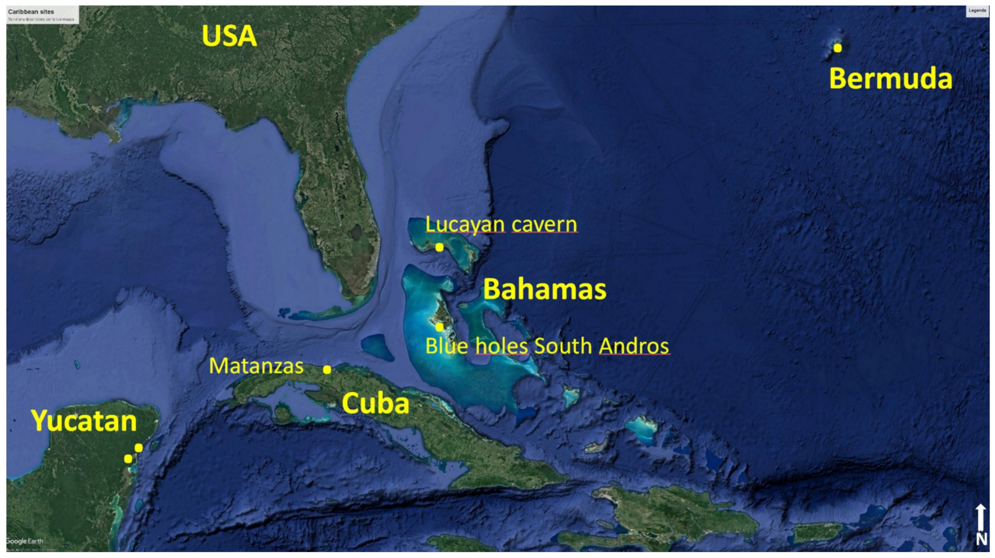
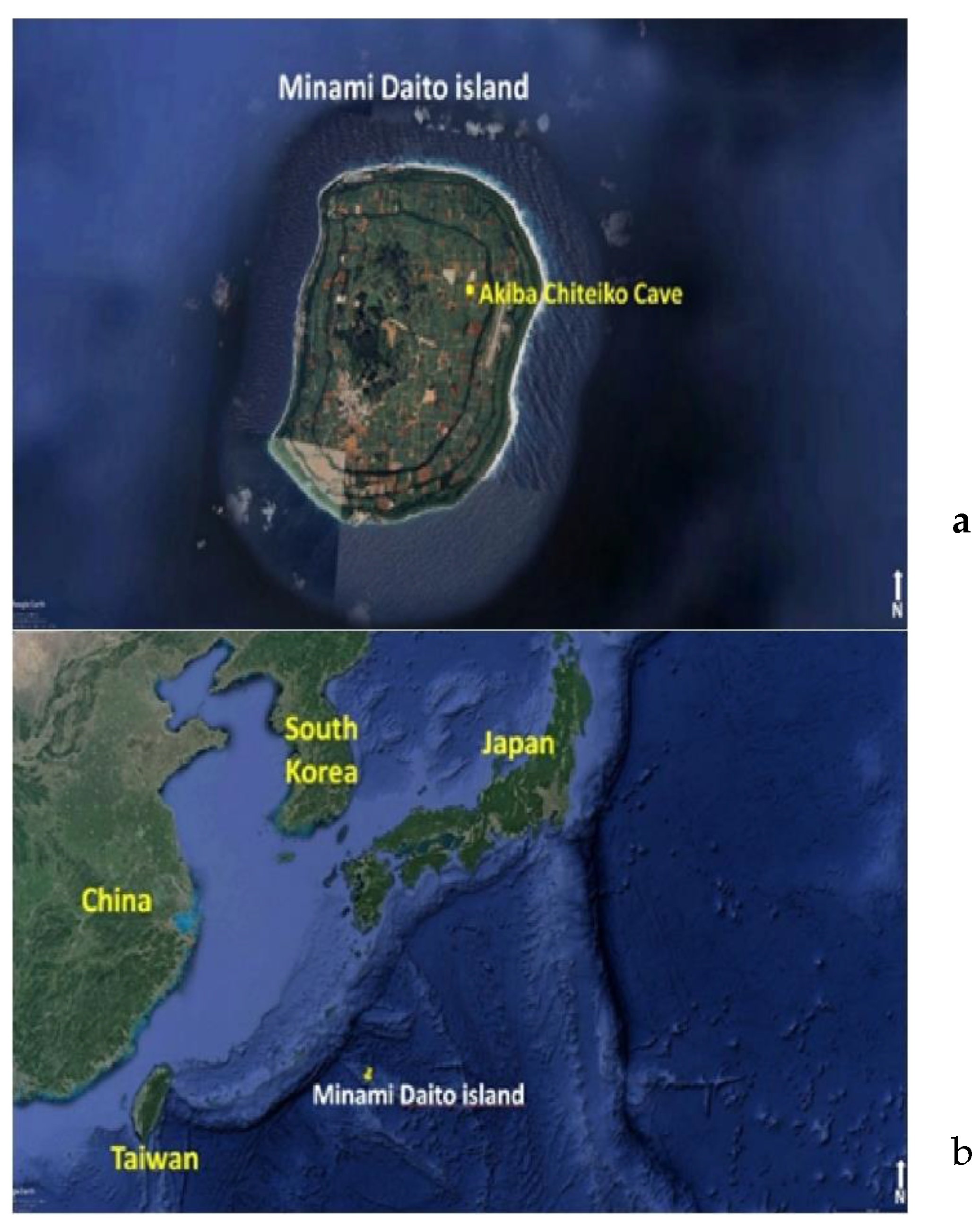
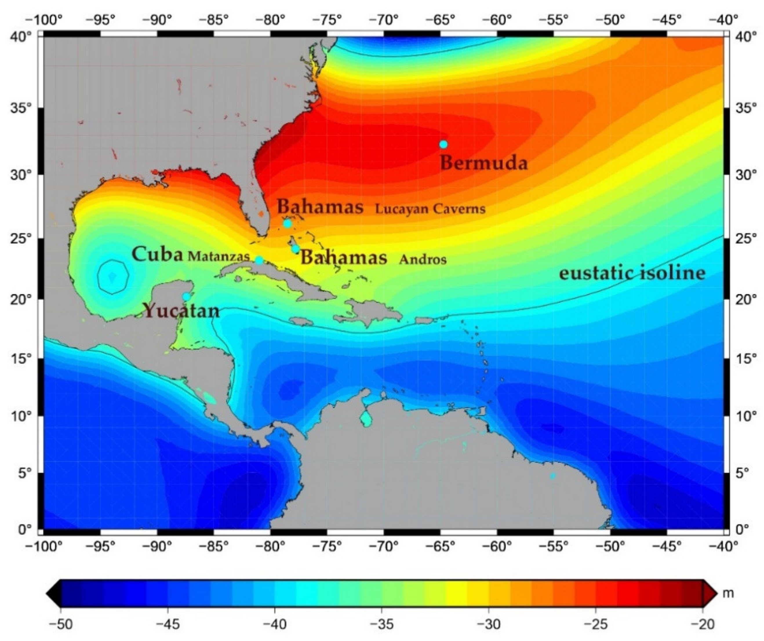
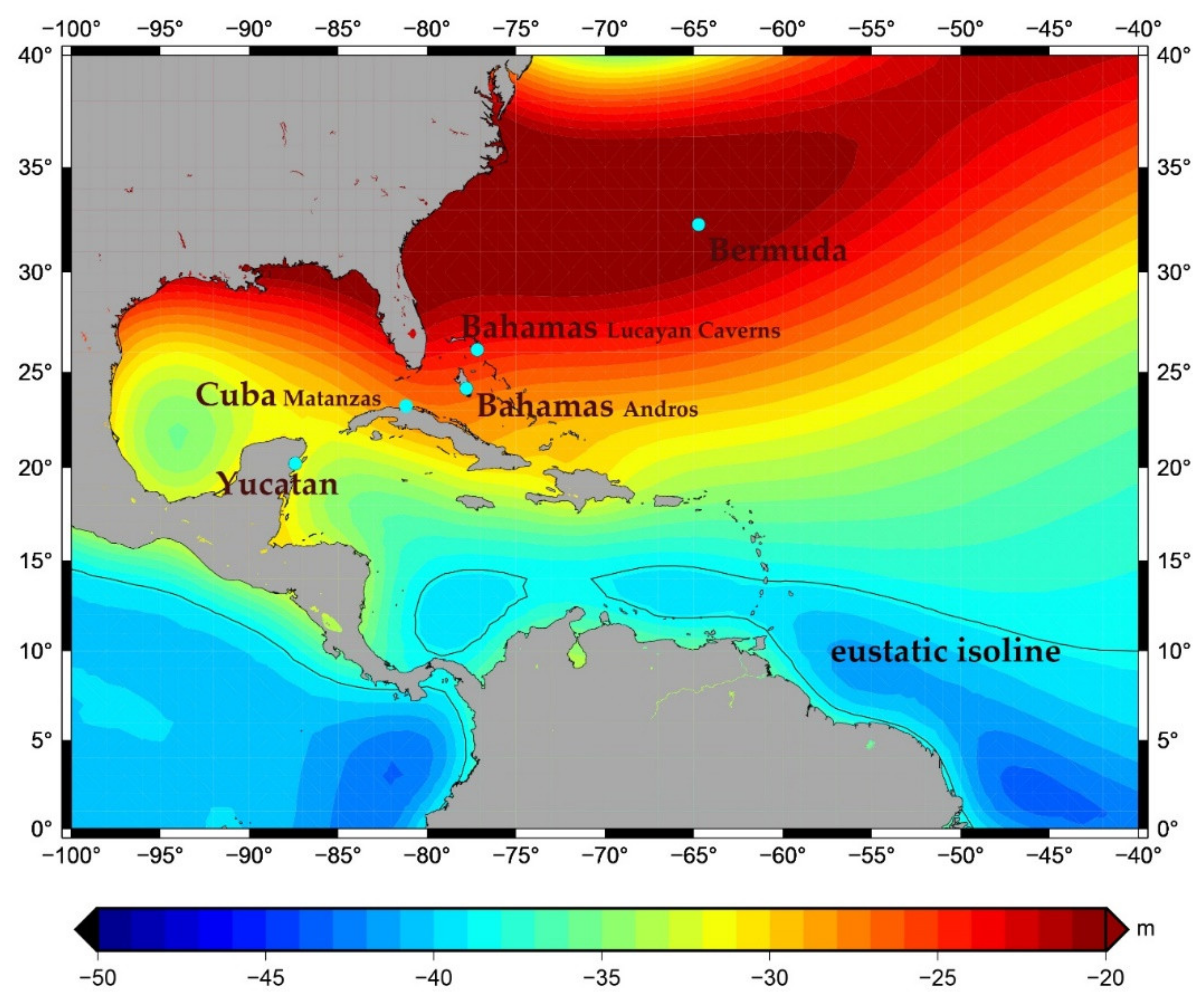
2.1. Western North Atlantic-Caribbean Region and Northern Philippine Sea
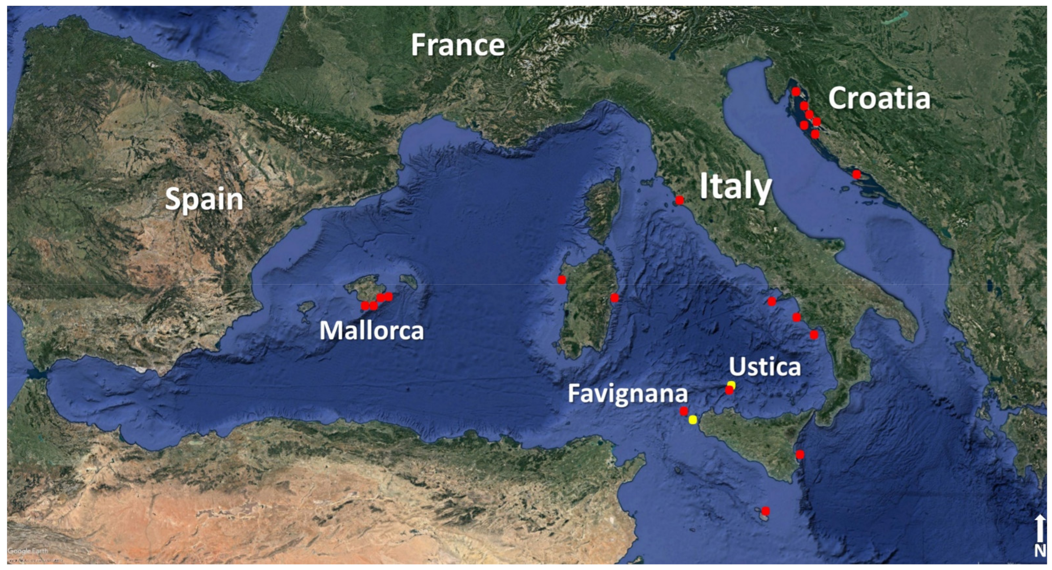
2.2. Mediterranean Region
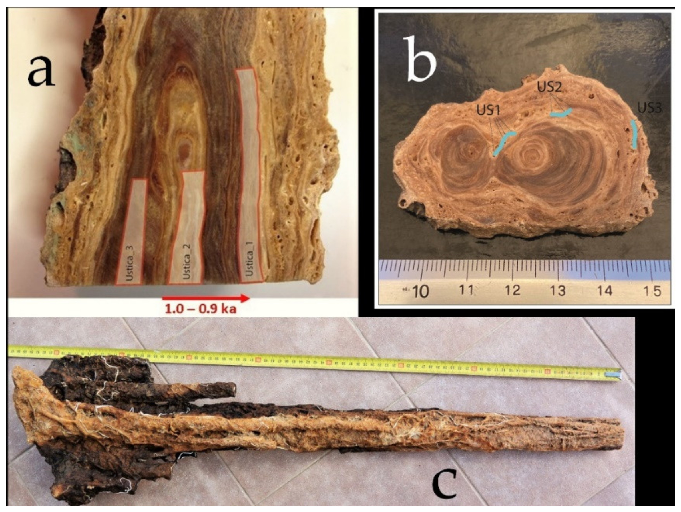
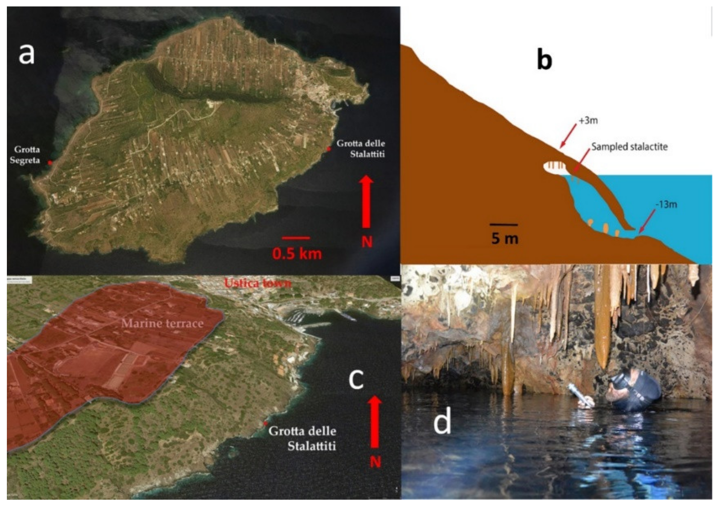
2.3. Ustica Island
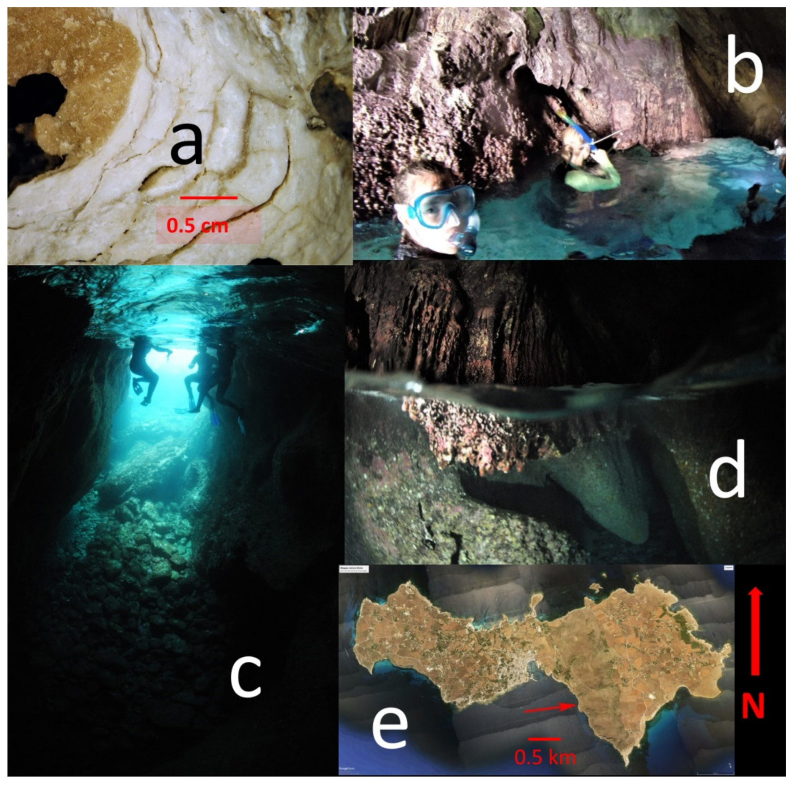
2.4. Favignana Island
2.5. Speleothem Sampling in Favignana and Ustica Islands


2.6. U-Th and 14C Dating

| Site | Coordinates (Lat °N, Long °E) | Sample Name | References | Dating Method | Time Range (kyr BP) | Depth (m) | Tectonic Corrections | GIA Corrections MIS 5.1 m | GIA Corrections MIS 5.3 m | Local Tide m |
|---|---|---|---|---|---|---|---|---|---|---|
| Yucatán Peninsula | 20.215 −87.4094 | Y01-7-2(S) Y01-10-2(S) Y01-22-1(F) Y01-23-2(F) | 10 | U-Th (MC-ICPMS) | 86.6–61.3 109.2–107.7 hiatus 75.8–70.9 95.3–68.9 115.2–93.8 | −14.6 −11 −11 −11 −9.9 −4.9 | No | −34 m | −32 | 0.3 |
| Yucatán Peninsula | 20.215 −87.4094 | 11 | U-Th (MC-ICPMS) | Marine: 8.9, 8.6, 8.4, 6 Cont.: 10.9, 8.4, 7.2, 5.8 | −6 | No | - | - | 0.3 | |
| Bermuda | 32.300 −64.7331 | QB | 9 | U-Th (MC-ICPMS) | 68–146 79–75 (hiatus) 84–82 (hiatus) 105-92 (hiatus) 137–114 (hiatus) | +1.5 | No | −23 m | −19 | 1.35 |
| Japan (Minami Daito Island) | 25.8440 −131.2301 | - | 13 | 14C-AMS | 5.1–4.6 | −0.35 | No | - | - | 1.5 |
| Cuba, Matanzas (Cueva de Santa Catalina) | 23.0859 −81.4184 | - | 12, 19 | U-Th (MC-ICPMS) | MIS 11, MIS 9, MIS 7, MIS 5 75.2–363.5 | +16 | Yes | −32 | −33 | 1.08 |
| Bahamas Lucayan Caverns | 26.13029 −77.17577 | Flowstone DWBAH | 3, 5 | U-Th (TIMS) | 38.8–337.5 5 marine hiati | −15, −10 | Yes | −27 | −24 | 1.3 |
| Bahamas Grand Bahamas South Andros. Sagittarius flowstone | 24.1502 −77.7821 | GB-89-25-5 | 4 | U-Th (TIMS) | 23.9–79.7; hiatus between 63.7 and 58.5. Tectonic was not considered | −18.1 | Yes | −32 | −27 | 1.35 |
| Sample | (238U) | (232Th) | δ234Um | (230Th/238U)act | (230Th/232Th)act | Age | Age corr |
|---|---|---|---|---|---|---|---|
| (µg/g) | (ng/g) | (‰) | (kyr) | (kyr BP) * | |||
| Ustica-1 | 1.194 (0.001) | 0.0483 (0.0005) | 67.4 (0.6) | 0.00939 (0.00007) | 702.7 (5.4) | 0.97 (0.01) | 0.89 (0.01) |
| Ustica-2 | 1.143 (0.001) | 0.0340 (0.0004) | 67.5 (0.8) | 0.01024 (0.00023) | 1041.5 (24.0) | 1.05 (0.03) | 0.98 (0.03) |
| Ustica-3 | 1.543 (0.002) | 0.0236 (0.0005) | 70.5 (0.9) | 0.00989 (0.00021) | 1944.3 (42.3) | 1.01 (0.02) | 0.95 (0.02) |
| Sample | Corrected Altitude (cm) | Radiocarbon Age (BP) | δ13C (‰) | Kind of markers | Cal BP 1 Sigma |
|---|---|---|---|---|---|
| LTL15761A | −32 ± 5 | 1912 ± 45 | +2 ± 0.7 | S2 serpulids | 1485–1304 1395 ± 45 |
| LTL15762A | −35 ± 15 | 806 ± 45 | +3 ± 0.5 | S3 phreatic | 735–675 705 ± 30 |
| LTL15762B | −32 ± 5 | 19,886 ± 100 | −29.5 ± 0.5 | S1 continental | 24,013–23,795 23,903 ± 109 |
| R–2741 * | −30 ± 10 | 531 ± 32 | +1.40 * | Cala Mancina St Vito Lo Capo | 232–106 169 ± 63 |
| R–2742 * | −30 ± 10 | 527 ± 36 | +1.33 * | Cala Mancina St Vito Lo Capo (Tp) | 232–94 163 ± 69 |
| R–2764 * | −30 ± 10 | 554 ± 35 | +1.31 * | Calazza (Pa) | 251–127 189 ± 62 |
| R–2580 * | −40 ± 10 | 784 ± 37 | +1.76 * | Barcarello (Pa) | 412–146 279 ± 133 |
2.7. Numerical Modelling of Glacial- and Hydro-Isostatic Adjustment and Sea-Level Change
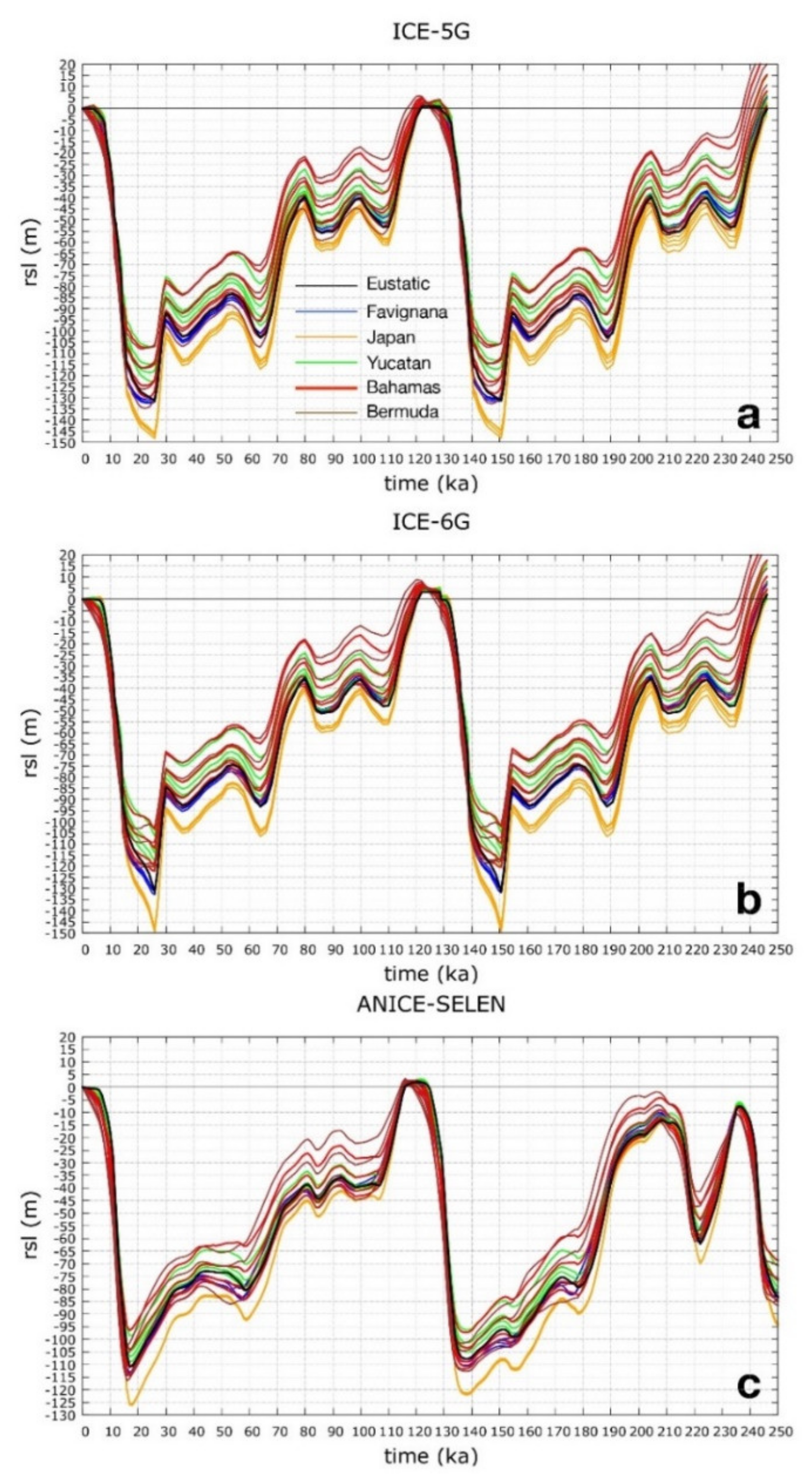
- ICE-5G [73]: This global model describes the ice-sheet thickness variation over North America, Eurasia, Greenland and Antarctica during the last 123 ka. Geological and modern geodetical observations were used to constrain the ice thickness chronology between 26 ka and the present day [6]. Through an iterative procedure, the SLE was solved for an a priori ice-sheet configuration and a prescribed fixed solid earth model (mantle viscosity profile and lithosphere thickness). The predicted RSL elevations and modern vertical rates were compared with paleo RSL indicators and measured crustal and geoidal vertical velocities, respectively. The differences between predictions and observations were then used to modify the ice-sheet models until a satisfactory solution is found. The ice-sheet volumetric evolution between 123 and 26 ka was tuned to the δ18O curve [74] and loosely constrained by surface geological evidence that defines the ice margins. Here, we combined two ICE-5G chronologies in order to cover the time span under consideration and to evaluate the GIA-modulated RSL response to the melting of the MIS 6 ice sheets during the MIS 5e. The latter is characterized by a ≈0.9 m eustatic sea-level highstand above the present-day mean sea level of between 129.5 ka and 123 ka, mostly coming from a reduced (with respect to present-day) Greenland Ice Sheet.
- ICE-6G [75]: This model is a modified version of ICE-5G. Here, we applied the same repetition as in the series of ICE-5G. According to the ICE-6G, the maximum MIS 5.5 eustatic highstand between 129 ka and 123 ka is ≈3.1 m above present-day msl as a consequence of reduced Greenland and West Antarctic Ice Sheets
- ANICE-SELEN [76,77]: This global chronology model is the result of an inverse forward modelling procedure where the δ18O stack [74] is decoupled into global ice-sheet volume and deep-water temperature. For this purpose, 3D thermomechanical ice-sheet models for North America, Eurasia, Greenland and Antarctica are dynamically coupled to SELEN to include all the GIA feedbacks. ANICE-SELEN is not yet constrained by geological or instrumental data. Here, we used the original ANICE-SELEN chronology, which is characterized by ≈2.5 m eustatic highstand during MIS 5 e (125–117 ka), in response to a reduced Greenland Ice-Sheet volume.
3. Results
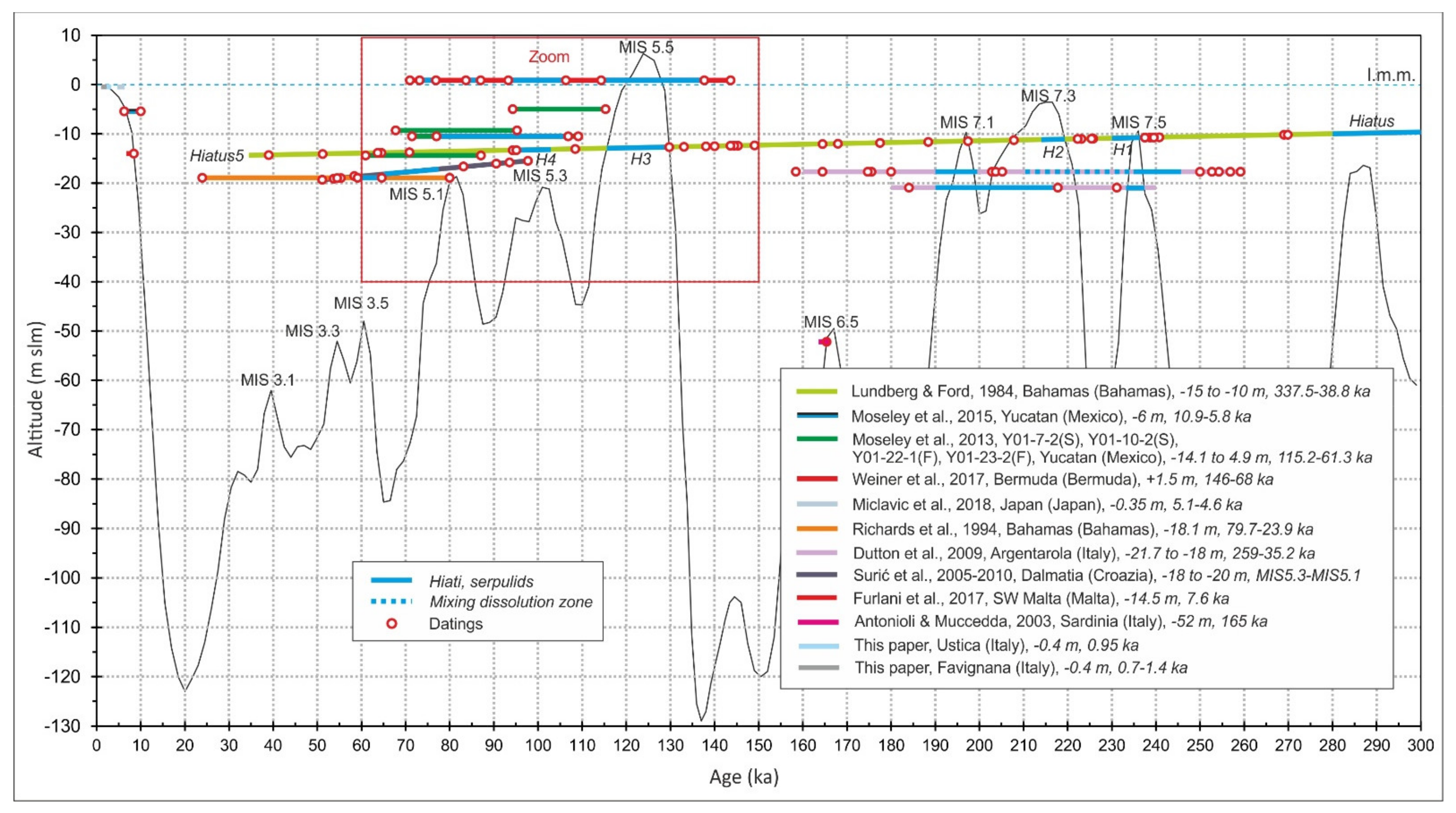
3.1. Review Data
3.1.1. Bermuda
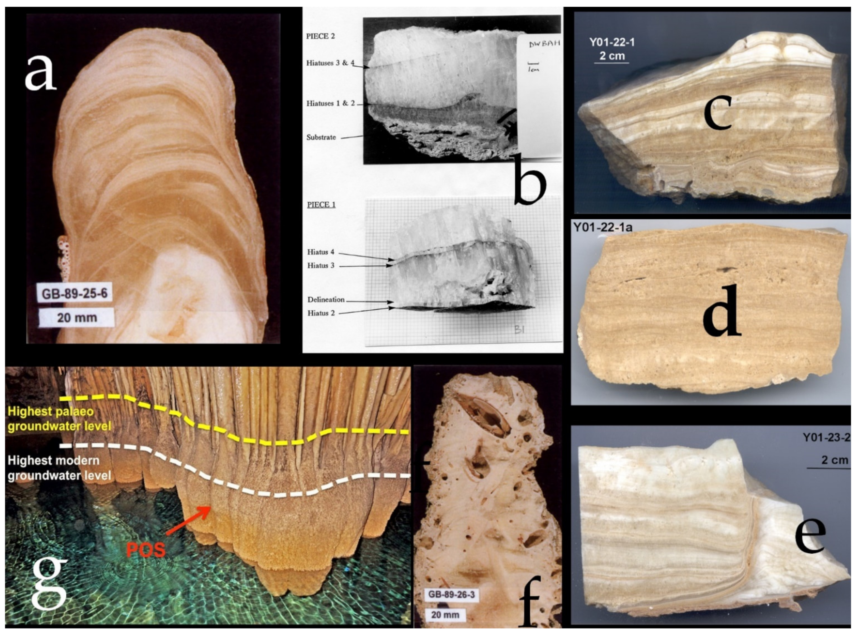
Andros Island (The Bahamas)
3.1.2. Lucayan Cavern DWBAH Flowstone (The Bahamas)
3.1.3. Santa Catalina Cave (Cuba)
3.1.4. Yucatán
3.1.5. Minami Daito Island (Japan)
3.2. New Data
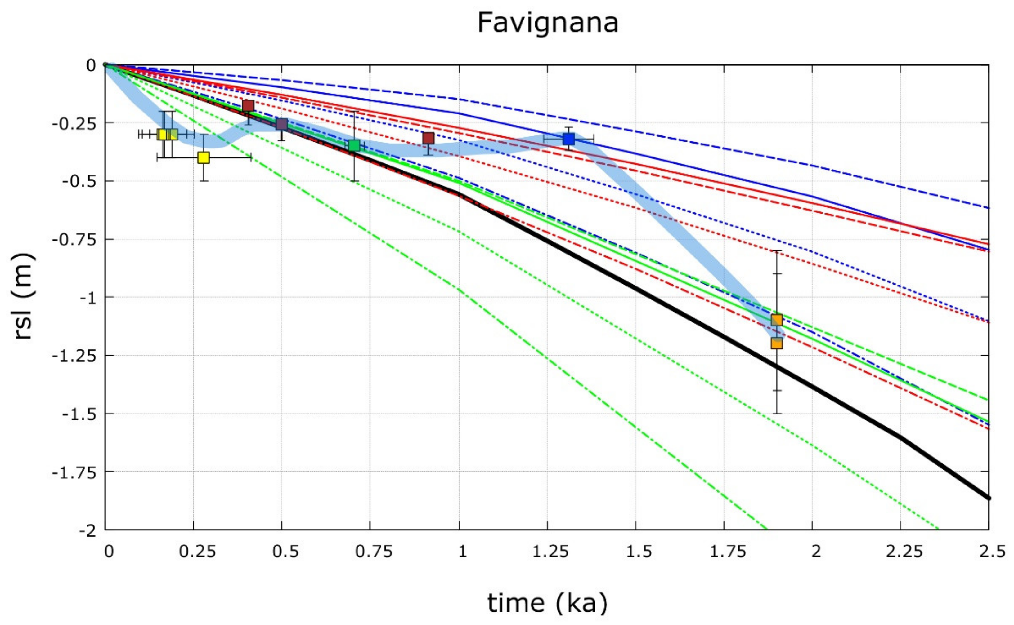
3.2.1. Favignana Island
3.2.2. Ustica
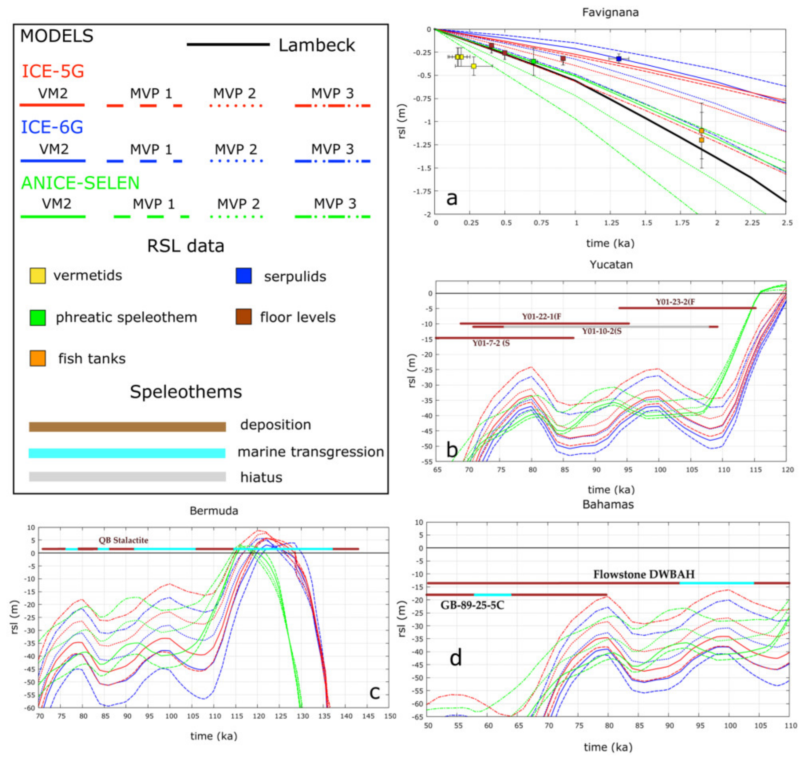
3.3. GIA Numerical Predictions
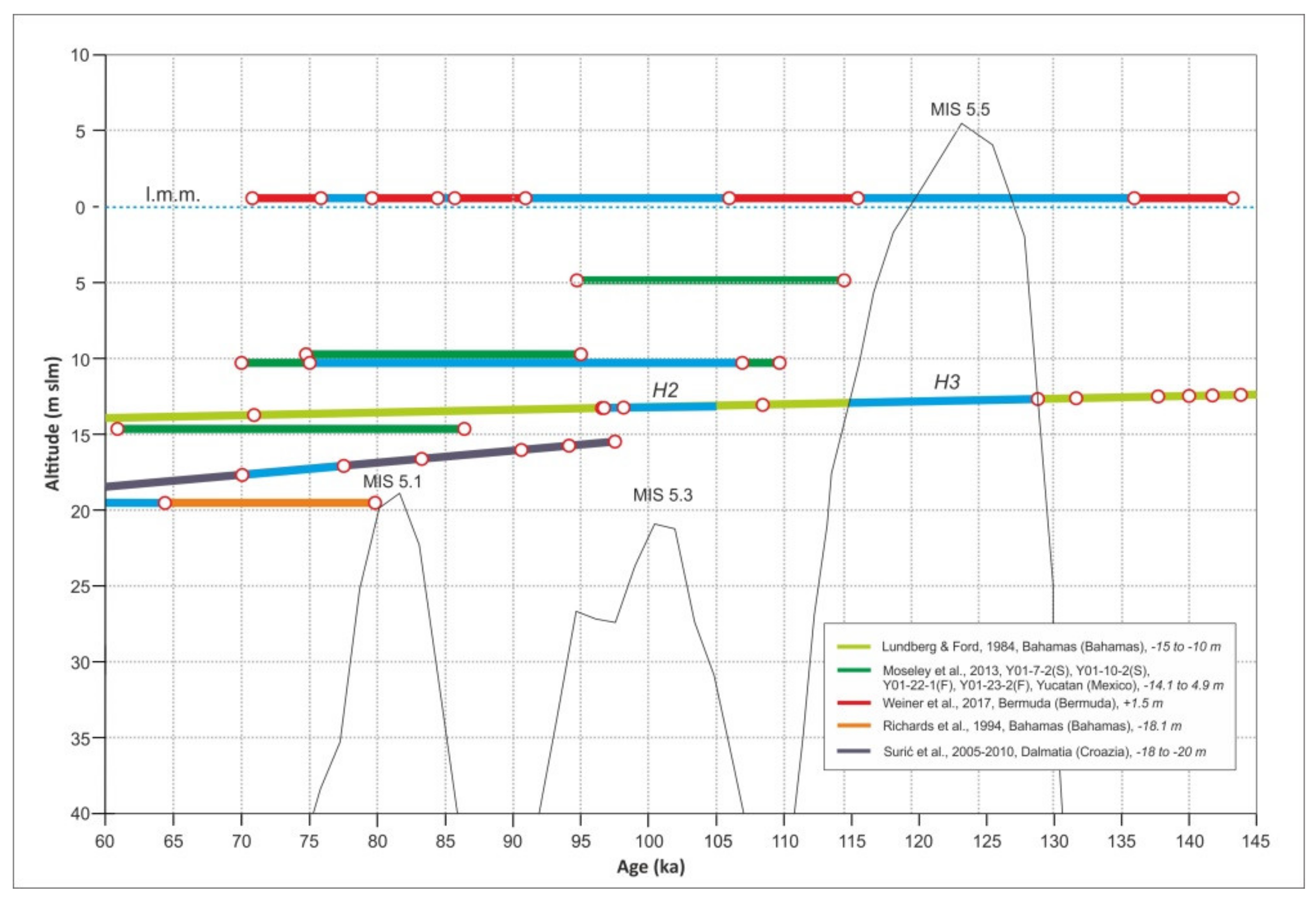
RSL Predictions vs. Observed Values (MIS 5.1–5.3)
4. Discussion
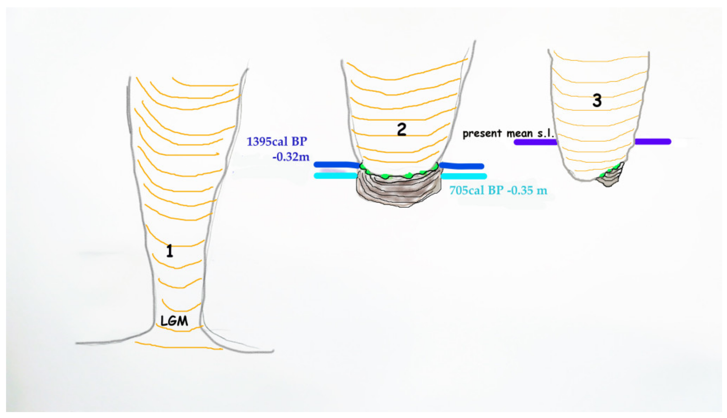
4.1. Favignana Stalactite
- (1)
- (2)
- (3)
- (4)
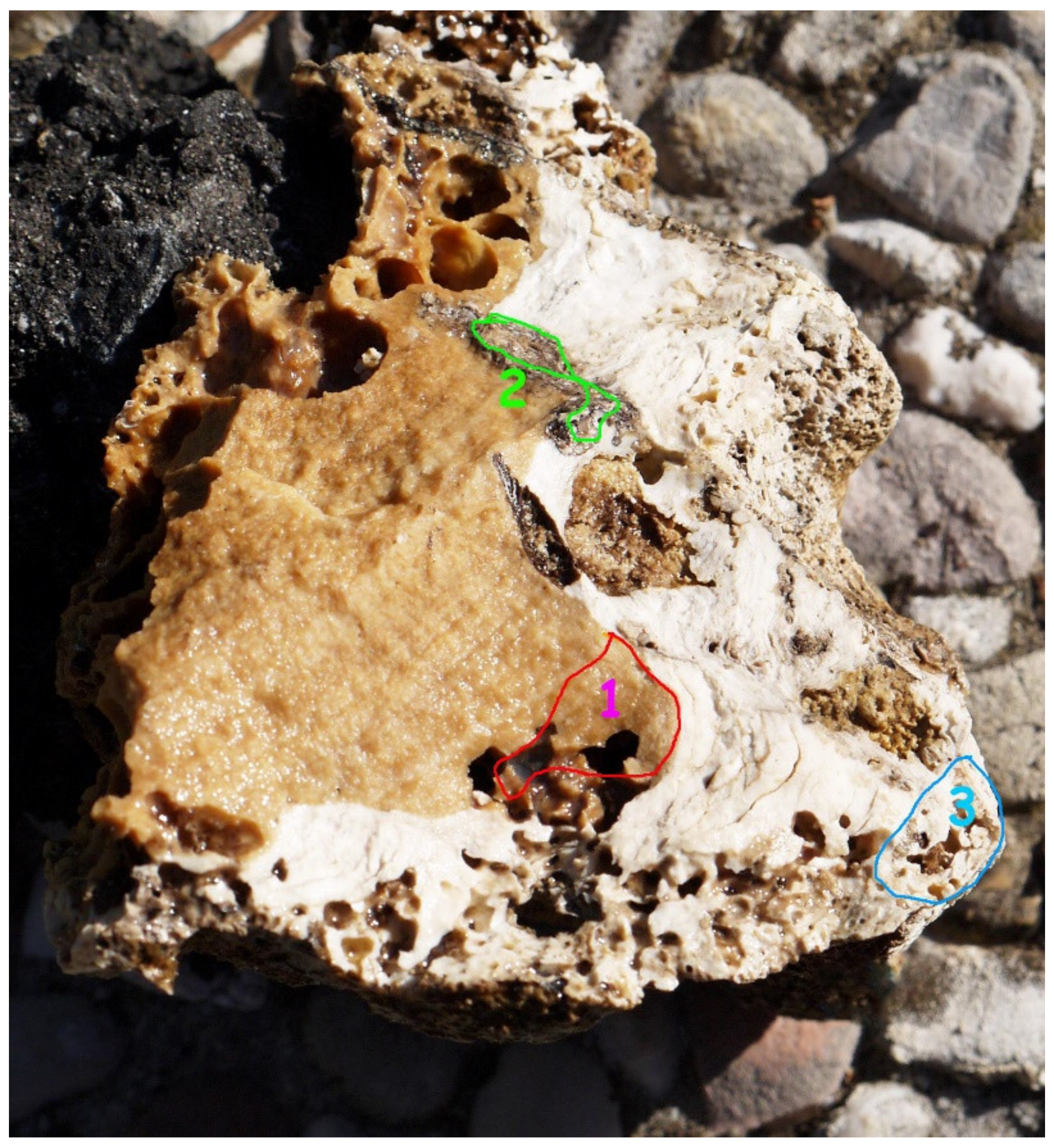
- The phreatic level was then interrupted by marine ingression, so that the submerged part of the stalactite was bored by Lithophaga sp., while the external carbonate surface of the submerged part of the speleothem was colonized by small serpulids, tetracorals, limpets, and sponges.
4.2. Ustica Stalactite
4.3. Speleothems from the Caribbean and Japan
4.3.1. MIS 2—Holocene
4.3.2. MIS 3
4.3.3. MIS 5.1
4.3.4. MIS 5.3
4.3.5. MIS 5.5
4.3.6. Middle Pleistocene
5. Conclusions
Author Contributions
Funding
Acknowledgments
Conflicts of Interest
Abbreviations
| MIS | Marine Isotope Stage |
| POS | Phreatic Overgrowth on Speleothems |
| MS | Mediterranean Sea |
| BSL | Below sea level |
| MSL | Mean Sea Level |
| AMS | Accelerator Mass Spectrometry |
| GIA | Glacial-and Hydro-Isostatic Adjustment |
| RSL | Relative Sea Level |
| SLE | Sea Level Equation |
| UM | Upper Mantle |
| LUM | Lower Upper Mantle |
| TZ | Transition Zone |
| LM | Lower Mantle |
| BP | Before Present |
| AD | Anno Domini |
| DCP | Dead Carbon Percentage |
| MPA | Marine Protected Area |
| DWBAH | Is the acronym of a submerged flowstone |
| QB | Is the acronym of a submerged stalagmite |
References
- Spalding, R.F.; Mathews, T.D. Stalagmites from Caves in the Bahamas: Indicators of Low Sea Level Stand. Quat. Res. 1972, 2, 470–472. [Google Scholar] [CrossRef]
- Ginés, A.; Ginés, J. Consideraciones sobre los Mecanismos de Fosilización de la “Cova de sa Bassa Blanca” y su Paralelismo con Formaciones Marinas del Cuaternario. Bolletí de la Societat d’Història Nat. de les Balears 1974, 19, 11–28. (In Spanish) [Google Scholar]
- Li, W.X.; Lundberg, J.; Dickin, A.P.; Ford, D.C.; Schwarcz, H.P.; McNutt, R.; Williams, D. High-Precision Mass-Spectrometric Uranium-Series Dating of Cave Deposits and Implications for Palaeoclimate Studies. Nature 1989, 339, 534–536. [Google Scholar] [CrossRef]
- Richards, D.A.; Smart, P.L.; Lawrence Edwards, R. Maximum Sea Levels for the Last Glacial Period from U-Series Ages of Submerged Speleothems. Nature 1994, 367, 357–360. [Google Scholar] [CrossRef]
- Lundberg, J.; Ford, D.C. Late Pleistocene Sea Level Change in the Bahamas from Mass Spectrometric U-Series Dating of Submerged Speleothem. Quat. Sci. Rev. 1994, 13, 1–14. [Google Scholar] [CrossRef]
- Antonioli, F.; Furlani, S.; Montagna, P.; Stocchi, P. The Use of Submerged Speleothems for Sea Level Studies in the Mediterranean Sea: A New Perspective Using Glacial Isostatic Adjustment (GIA). Geosciences 2021, 11, 77. [Google Scholar] [CrossRef]
- Gascoyne, M.; Benjamin, G.J.; Schwarcz, H.P.; Ford, D.C. Sea-Level Lowering during the Illinoian Glaciation: Evidence from a Bahama “Blue Hole”. Science 1979, 205, 806–808. [Google Scholar] [CrossRef] [PubMed]
- Harmon, R.S.; Land, L.S.; Mitterer, R.M.; Garrett, P.; Schwarcz, H.P.; Larson, G.J. Bermuda Sea Level During the Last Interglacial. Nature 1981, 289, 481–483. [Google Scholar] [CrossRef]
- Wainer, K.A.I.; Rowe, M.P.; Thomas, A.L.; Mason, A.J.; Williams, B.; Tamisiea, M.E.; Williams, F.H.; Düsterhus, A.; Henderson, G.M. Speleothem Evidence for MIS 5c and 5a Sea Level Above Modern Level at Bermuda. Earth Planet. Sci. Lett. 2017, 457, 325–334. [Google Scholar] [CrossRef] [Green Version]
- Moseley, G.; Smart, P.L.; Richards, D.A.; Hoffmann, D.L. Speleothem Constraints on Marine Isotope Stage (MIS) 5 Relative Sea Levels, Yucatán Peninsula, Mexico. J. Quat. Sci. 2013, 28, 293–300. [Google Scholar] [CrossRef]
- Moseley, G.E.; Richards, D.A.; Smart, P.L.; Standish, C.D.; Hoffmann, D.L.; ten Hove, H.; Vinn, O. Early–Middle Holocene Relative Sea-Level Oscillation Events Recorded in a Submerged Speleothem from the Yucatán Peninsula, Mexico. Holocene 2015, 25, 1511–1521. [Google Scholar] [CrossRef]
- De Waele, J.; D’Angeli, I.M.; Bontognali, T.; Tuccimei, P.; Scholz, D.; Jochum, K.P.; Columbu, A.; Bernasconi, S.M.; Fornós, J.J.; Grau González, E.R.; et al. Speleothems in a North Cuban Cave Register Sea-Level Changes and Pleistocene Uplift Rates. Earth Surf. Process. Landf. 2018, 43, 2313–2326. [Google Scholar] [CrossRef]
- Miklavič, B.; Yokoyama, Y.; Urata, K.; Miyairi, Y.; Kan, H. Holocene Relative Sea Level History from Phreatic Overgrowths on Speleothems (POS) on Minami Daito Island, Northern Philippine Sea. Quat. Int. 2018, 471, 359–368. [Google Scholar] [CrossRef]
- Van Hengstum, P.J.; Richards, D.A.; Onac, B.P.; Dorale, J.A. Coastal Caves and Sinkholes. In Handbook of Sea-Level Research; John Wiley & Sons, Ltd.: Chichester, UK, 2015; pp. 83–103. [Google Scholar]
- Dumitru, O.A.; Polyak, V.J.; Asmerom, Y.; Onac, B.P. Last Interglacial (Sensu Latu, ~130 To 75 Ka) Sea Level History from Cave Deposits: A Global Standardized Database. Earth Syst. Sci. Data Discuss. 2020, 2020, 1–25. [Google Scholar] [CrossRef]
- Mylroie, J.E.; Lace, M.J.; Kambesis, P.N.; Mylroie, J.R. Karst Processes and Estuarine Coastlines. In Encyclopedia of Estuaries; Encyclopedia of Earth Sciences Series; Kennish, M.J., Ed.; Springer: Dordrecht, The Netherlands, 2016; pp. 373–380. ISBN 978-94-017-8801-4. [Google Scholar]
- Emery, K.O.; Uchupi, E. Western North Atlantic Ocean: Topography, Rocks, Structure, Water, Life, and Sediments. Amer. Ass. Pet. Geol. 1972, 17, A532. [Google Scholar]
- Smart, P.L.; Beddows, P.A.; Coke, J.; Doerr, S.; Smith, S.; Whitaker, F.F. Cave Development on the Caribbean Coast of the Yucatán Peninsula, Quintana Roo, Mexico. In Perspectives on Karst Geomorphology, Hydrology, and Geochemistry—A Tribute Volume to Derek, C. Ford and William B. White; Harmon, R.S., Wicks, C.M., Eds.; Geological Society of America: Boulder, CO, USA, 2006; Volume 404, ISBN 9780813724041. [Google Scholar]
- De Waele, J.; D’Angeli, I.M.; Tisato, N.; Tuccimei, P.; Soligo, M.; Ginés, J.; Ginés, A.; Fornós, J.J.; Villa, I.M.; Grau González, E.R.; et al. Coastal Uplift Rate at Matanzas (Cuba) Inferred From MIS5e Phreatic Overgrowths on Speleothems. Terra Nov. 2017, 29, 98–105. [Google Scholar] [CrossRef]
- Cabrera, M.; Penalver, L.L. Contribuci_On A La Estratigraf_Ia De Los Dep_Ositos Cuaternarios De Cuba. Cuatern. Geomorfol. Rev. Soc. Esp. Geomorfol. Asoc. Esp. Estud. Cuatern. 2001, 15, 37–49. [Google Scholar]
- Hearty, P.J.; Kindler, P. The Stratigraphy and Surficial Geology of New Providence and Surrounding Islands, Bahamas. J. Coast. Res. 1997, 13, 798–812. [Google Scholar]
- Vacher, L.; Quinn, T. Geology and Hydrogeology of Carbonate Islands; Elsevier Science: Amsterdam, The Netherlands, 1997; ISBN 9780080532479. [Google Scholar]
- Ohde, S.; Elderfield, H. Strontium Isotope Stratigraphy of Kita-Daito-Jima Atoll, North Philippine Sea: Implications for Neogene Sea-Level Change and Tectonic History. Earth Planet. Sci. Lett. 1992, 113, 473–486. [Google Scholar] [CrossRef]
- Tam, E.; Yokoyama, Y. A Review of MIS 5e Sea-Level Proxies around Japan. Earth Syst. Sci. Data 2021, 13, 1477–1497. [Google Scholar] [CrossRef]
- Stocchi, P.; Antonioli, F.; Montagna, P.; Pepe, F.; Lo Presti, V.; Caruso, A.; Corradino, M.; Dardanelli, G.; Renda, P.; Frank, N.; et al. A Stalactite Record of Four Relative Sea-Level Highstands during the Middle Pleistocene Transition. Quat. Sci. Rev. 2017, 173, 92–100. [Google Scholar] [CrossRef] [Green Version]
- Surić, M.; Richards, D.A.; Hoffmann, D.L.; Tibljaš, D.; Juračić, M. Sea-Level Change during MIS 5a Based on Submerged Speleothems from the Eastern Adriatic Sea (Croatia). Mar. Geol. 2009, 262, 62–67. [Google Scholar] [CrossRef]
- Vesica, P.L.; Tuccimei, P.; Turi, B.; Fornós, J.J.; Ginés, A.; Ginés, J. Late Pleistocene Paleoclimates and Sea-Level Change in the Mediterranean as Inferred from Stable Isotope and U-Series Studies of Overgrowths on Speleothems, Mallorca, Spain. Quat. Sci. Rev. 2000, 19, 865–879. [Google Scholar] [CrossRef]
- Tuccimei, P.; Soligo, M.; Ginés, J.; Ginés, A.; Fornós, J.; Kramers, J.; Villa, I.M. Constraining Holocene Sea Levels Using U-Th Ages of Phreatic Overgrowths on Speleothems from Coastal Caves in Mallorca (Western Mediterranean). Earth Surf. Process. Landf. 2010, 35, 782–790. [Google Scholar] [CrossRef]
- Dorale, J.A.; Onac, B.P.; Fornós, J.J.; Ginés, J.; Ginés, A.; Tuccimei, P.; Peate, D.W. Sea-Level Highstand 81,000 Years Ago in Mallorca. Science 2010, 327, 860–863. [Google Scholar] [CrossRef]
- Polyak, V.J.; Onac, B.P.; Fornós, J.J.; Hay, C.; Asmerom, Y.; Dorale, J.A.; Ginés, J.; Tuccimei, P.; Ginés, A. A Highly Resolved Record of Relative Sea Level in the Western Mediterranean Sea during the Last Interglacial Period. Nat. Geosci. 2018, 11, 860–864. [Google Scholar] [CrossRef]
- Lucia, G.; Polyak, V.J.; Ginés, J.; Fornòs, J.J.; Ginés, A.; Asmerom, Y.; Onac, B.P. Chronology of Middle Pleistocene Coastal Karst Evolution and Relative Sea-Level Changes in Mallorca. J. Coast. Res. 2020, in press. [Google Scholar] [CrossRef]
- Alessio, M.; Allegri, L.; Antonioli, F.; Belluomini, G.; Ferranti, L.; Improta, S.; Manfra, L.; Proposito, A. Risultati Preliminari Relativi alla Datazione di Speleotemi Sommersi Nelle Fasce Costiere del Tirreno Centrale. G. Geol. 1992, 54, 165–194. (In Italian) [Google Scholar]
- Dutton, A.; Scicchitano, G.; Monaco, C.; Desmarchelier, J.M.; Antonioli, F.; Lambeck, K.; Esat, T.M.; Fifield, L.K.; McCulloch, M.T.; Mortimer, G. Uplift Rates Defined by U-Series and 14C Ages of Serpulid-Encrusted Speleothems from Submerged Caves Near Siracusa, Sicily (Italy). Quat. Geochronol. 2009, 4, 2–10. [Google Scholar] [CrossRef]
- Dutton, A.; Bard, E.; Antonioli, F.; Esat, T.M.; Lambeck, K.; McCulloch, M.T. Phasing and Amplitude of Sea-Level and Climate Change during the Penultimate Interglacial. Nat. Geosci. 2009, 2, 355–359. [Google Scholar] [CrossRef]
- Surić, M.; Lončarić, R.; Lončar, N. Submerged Caves of Croatia: Distribution, Classification and Origin. Environ. Earth Sci. 2010, 61, 1473–1480. [Google Scholar] [CrossRef]
- Furlani, S.; Antonioli, F.; Gambin, T.; Biolchi, S.; Formosa, S.; Lo Presti, V.; Mantovani, M.; Anzidei, M.; Calcagnile, L.; Quarta, G. Submerged Speleothem in Malta Indicates Tectonic Stability throughout the Holocene. Holocene 2018, 28, 1588–1597. [Google Scholar] [CrossRef]
- Alessio, M.; Allegri, L.; Antonioli, F.; Belluomini, G.; Impronta, S.; Manfra, L.; Preite, M. La Curva di Risalita del Mare Tirreno Negli Ultimi 43 Ka Ricavata da Datazioni Su Speleotemi Sommersi E Dati Archeologici. Mem. Descr. Serv. Geol. Naz. 1994, 52, 261–276. [Google Scholar]
- Antonioli, F.; Bard, E.; Potter, E.K.; Silenzi, S.; Improta, S. 215-ka History of Sea-Level Oscillations from Marine and Continental Layers in Argentarola Cave Speleothems (Italy). Glob. Planet. Chang. 2004, 43, 57–78. [Google Scholar] [CrossRef]
- Furlani, S.; Pappalardo, M.; Gómez-Pujol, L.; Chelli, A. The Rock Coast of the Mediterranean and Black Seas. Geol. Soc. Mem. 2014, 40, 89–123. [Google Scholar] [CrossRef]
- Rohling, E.J.; Abu-Zied, R.; Casford, C.S.L.; Hayes, A.; Hoogakker, B.A.A. The Mediterranean Sea: Present and Past. In Physical Geography of the Mediterranean Basin; Oxford University Press: Oxford, UK, 2009; ISBN 978-0-19-926803-0. [Google Scholar]
- Giese, P.; Morelli, C. La Struttura Della Crosta Terrestre in Italia. Accad. Naz. Lincei 1973, 183, 317–362. (In Italian) [Google Scholar]
- Sulli, A.; Zizzo, E.; Spatola, D.; Gasparo Morticelli, M.; Agate, M.; Lo Iacono, C.; Gargano, F.; Pepe, F.; Ciaccio, G. Growth and Geomorphic Evolution of the Ustica Volcanic Complex at the Africa-Europe Plate Margin (Tyrrhenian Sea). Geomorphology 2021, 374, 107526. [Google Scholar] [CrossRef]
- Bousquet, J.C.; Lanzafame, G. Transition from Tyrrhenian basin extension to collisional tectonics: Evidence of N-S compression during the recent Quaternary at Ustica (southern Tyrrhenian Sea, Italy). C.R. Acad. Sc. Paris 1995, 321, 781–787. [Google Scholar]
- Bonomo, R.; Ricci, V. Application of Unconformity-Bounded Stratigraphic (UBS) Units to the Geological Survey of the Volcanic Island Ustica (Italy). In Stratigraphy and Geology of Volcanic Areas; Groppelli, G., Viereck-Goette, L., Eds.; Geological Society of America: Boulder, CO, USA, 2010; Volume 464, pp. 51–61. ISBN 9780813724645. [Google Scholar]
- Romano, R.; Sturiale, C. L’isola di Ustica: Studio Geo-Vulcanologico e Magmatologico. Riv. Miner. Sicil. 1971, 22, 3–61. (In Italian) [Google Scholar]
- De Vita, S. Assetto Geologico-Strutturale ed Evoluzione Vulcanologica Dell’isola di Ustica (Stratigrafia, Tettonica e Meccanismi Eruttivi). Ph.D. Thesis, Università degli Studi di Napoli Federico II, Napoli, Italy, 1993. [Google Scholar]
- De Vita, S.; Guzzetta, G.; Orsi, G. Deformational Features of the Ustica Volcanic Island in the Southern Tyrrhenian Sea (Italy). Terra Nov. 1995, 7, 623–629. [Google Scholar] [CrossRef]
- Peccerillo, A. Plio-Quaternary Volcanism in Italy; Springer: Berlin/Heidelberg, Germany, 2005; ISBN 978-3-540-25885-8. [Google Scholar]
- De Vita, S.; Laurenzi, M.A.; Orsi, G.; Voltaggio, M. Application of 40ar/39ar and 230th Dating Methods to the Chronostratigraphy of Quaternary Basaltic Volcanic Areas: The Ustica Island Case History. Quat. Int. 1998, 47–48, 117–127. [Google Scholar] [CrossRef]
- Cinque, A.; Civetta, L.; Orsi, G.; Peccerillo, A. Geology and geochemistry of the Island of Ustica (Southern Tyrrhenian Sea). Boll. Soc. Ital. Miner. Pet. 1998, 43, 987–1002. [Google Scholar]
- Furlani, S.; Antonioli, F.; Cavallaro, D.; Chirco, P.; Caldareri, F.; Martin, F.F.; Morticelli, M.G.; Monaco, C.; Sulli, A.; Quarta, G.; et al. Tidal Notches, Coastal Landforms and Relative Sea-Level Changes during the Late Quaternary at Ustica Island (Tyrrhenian Sea, Italy). Geomorphology 2017, 299, 94–106. [Google Scholar] [CrossRef]
- De Vita, S.; Foresta Martin, F. The Palaeogeographic Setting and the Local Environmental Impact of the 130 Ka Falconiera Tuff-Cone Eruption (Ustica Island, Italy). Ann. Geophys. 2017, 60. [Google Scholar] [CrossRef] [Green Version]
- De Vita, S.; Orsi, G. I Terrazzi Marini dell’isola di Ustica (Mar Tirreno Meridionale, Italia). Mem. Descr. Carta Geol. D’It 1994, 52, 405–406. (In Italian) [Google Scholar]
- Incandela, A. Deformazioni Neogeniche Nelle Isole di Favignana e Levanzo (Isole Egadi). Mem. Soc. Geol. It. 1996, 51, 129–135. (In Italian) [Google Scholar]
- Abate, B.; Incandela, A.; Renda, P. Carta Geologica delle Isole di Favignana e Levanzo; University of Palermo: Palermo, Italy, 1997. [Google Scholar]
- Lo Presti, V.; Antonioli, F.; Palombo, M.R.; Agnesi, V.; Biolchi, S.; Calcagnile, L.; di Patti, C.; Donati, S.; Furlani, S.; Merizzi, J.; et al. Palaeogeographical Evolution of the Egadi Islands (Western Sicily, Italy). Implications for Late Pleistocene and Early Holocene Sea Crossings by Humans and Other Mammals in the Western Mediterranean. Earth. Sci. Rev. 2019, 194, 160–181. [Google Scholar] [CrossRef]
- Hearty, P.J.; Miller, G.H.; Stearns, C.E.; Szabo, B.J. Aminostratigraphy of Quaternary Shorelines in the Mediterranean Basin. Geol. Soc. Am. Bull. 1986, 97, 850–858. [Google Scholar] [CrossRef]
- Antonioli, F.; Cremona, G.; Immordino, F.; Puglisi, C.; Romagnoli, C.; Silenzi, S.; Valpreda, E.; Verrubbi, V. New Data on the Holocenic Sea-Level Rise in NW Sicily (Central Mediterranean Sea). Glob. Planet. Chang. 2002, 34, 121–140. [Google Scholar] [CrossRef]
- Antonioli, F.; Ferranti, L.; Stocchi, P.; Deiana, G.; Lo Presti, V.; Furlani, S.; Marino, C.; Orru, P.; Scicchitano, G.; Trainito, E.; et al. Morphometry and Elevation of the Last Interglacial Tidal Notches in Tectonically Stable Coasts of the Mediterranean Sea. Earth Sci. Rev. 2018, 185, 600–623. [Google Scholar]
- Pons-Branchu, E.; Douville, E.; Roy-Barman, M.; Dumont, E.; Branchu, P.; Thil, F.; Frank, N.; Bordier, L.; Borst, W. A Geochemical Perspective on Parisian Urban History Based on U-Th Dating, Laminae Counting and Yttrium and REE Concentrations of Recent Carbonates in Underground Aqueducts. Quat. Geochronol. 2014, 24, 44–53. [Google Scholar] [CrossRef] [Green Version]
- Ludwig, K.R.; Titterington, D.M. Calculation of 230Th U Isochrons, Ages, and Errors. Geochim. Cosmochim. Acta 1994, 58, 5031–5042. [Google Scholar] [CrossRef]
- Cheng, H.; Lawrence Edwards, R.; Shen, C.C.; Polyak, V.J.; Asmerom, Y.; Woodhead, J.; Hellstrom, J.; Wang, Y.; Kong, X.; Spötl, C.; et al. Improvements in 230Th Dating, 230Th and 234U Half-Life Values, and U-Th Isotopic Measurements by Multi-Collector Inductively Coupled Plasma Mass Spectrometry. Earth Planet. Sci. Lett. 2013, 371–372, 82–91. [Google Scholar] [CrossRef]
- Jaffey, A.H.; Flynn, K.F.; Glendenin, L.E.; Bentley, W.C.; Essling, A.M. Precision Measurement of Half-Lives and Specific Activities of U235 and U238. Phys. Rev. C 1971, 4, 1889–1906. [Google Scholar] [CrossRef]
- Hellstrom, J. U–Th Dating of Speleothems with High Initial 230Th Using Stratigraphical Constraint. Quat. Geochronol. 2006, 1, 289–295. [Google Scholar] [CrossRef]
- Antonioli, F.; Chemello, R.; Improta, S.; Riggio, S. Dendropoma Lower Intertidal Reef Formations and Their Palaeoclimatological Significance, NW Sicily. Mar. Geol. 1999, 161, 155–170. [Google Scholar] [CrossRef]
- Reimer, P.J.; Austin, W.E.N.; Bard, E.; Bayliss, A.; Blackwell, P.G.; Bronk Ramsey, C.; Butzin, M.; Cheng, H.; Edwards, R.L.; Friedrich, M.; et al. The IntCal20 Northern Hemisphere Radiocarbon Age Calibration Curve (0-55 cal kBP). Radiocarbon 2020, 62, 725–757. [Google Scholar] [CrossRef]
- Calcagnile, L.; Maruccio, L.; Scrimieri, L.; delle Side, D.; Braione, E.; D’Elia, M.; Quarta, G. Development and application of facilities at the Centre for Applied Physics, Dating and Diagnostics (CEDAD) at the University of Salento during the last 15 years. Nucl. Instrum. Methods Phys. Res. Sect. B Beam Interact. Mater. At. 2019, 456, 252–256. [Google Scholar] [CrossRef]
- Heaton, T.J.; Köhler, P.; Butzin, M.; Bard, E.; Reimer, R.W.; Austin, W.E.N.; Bronk Ramsey, C.; Grootes, P.M.; Hughen, K.A.; Kromer, B.; et al. Marine20—The Marine Radiocarbon Age Calibration Curve (0–55,000 cal BP). Radiocarbon 2020, 62, 779–820. [Google Scholar] [CrossRef]
- Siani, G.; Paterne, M.; Arnold, M.; Bard, E.; Métivier, B.; Tisnerat, N.; Bassinot, F. Radiocarbon Reservoir Ages in the Mediterranean Sea and Black Sea. Radiocarbon 2000, 42, 271–280. [Google Scholar] [CrossRef] [Green Version]
- Farrell, W.E.; Clark, J.A. On Postglacial Sea Level. Geophys. J. R. Astron. Soc. 2007, 46, 647–667. [Google Scholar] [CrossRef]
- Spada, G.; Stocchi, P. SELEN: A Fortran 90 Program for Solving the “Sea-Level Equation”. Comput. Geosci. 2007, 33, 538–562. [Google Scholar] [CrossRef]
- Stocchi, P.; Vacchi, M.; Lorscheid, T.; de Boer, B.; Simms, A.R.; van de Wal, R.S.W.; Vermeersen, B.L.A.; Pappalardo, M.; Rovere, A. MIS 5e Relative Sea-Level Changes in the Mediterranean Sea: Contribution of Isostatic Disequilibrium. Quat. Sci. Rev. 2018, 185, 122–134. [Google Scholar] [CrossRef] [Green Version]
- Peltier, W.R. Global Glacial Isostasy and the Surface of the Ice-Age Earth: The ICE-5G (VM2) Model and GRACE. Annu. Rev. Earth Planet. Sci. 2004, 32, 111–149. [Google Scholar] [CrossRef]
- Lisiecki, L.E.; Raymo, M.E. A Pliocene-Pleistocene Stack of 57 Globally Distributed Benthic Δ 18O Records. Paleoceanography 2005, 20, 1–17. [Google Scholar] [CrossRef] [Green Version]
- Argus, D.F.; Peltier, W.R.; Drummond, R.; Moore, A.W. The Antarctica Component of Postglacial Rebound Model ICE-6G_C (VM5a) Based on GPS Positioning, Exposure Age Dating of Ice Thicknesses, and Relative Sea Level Histories. Geophys. J. Int. 2014, 198, 537–563. [Google Scholar] [CrossRef]
- De Boer, B.; Stocchi, P.; van de Wal, R.S.W. A Fully Coupled 3-D Ice-Sheet–Sea-Level Model: Algorithm and Applications. Geosci. Model. Dev. 2014, 7, 2141–2156. [Google Scholar] [CrossRef] [Green Version]
- De Boer, B.; Stocchi, P.; Whitehouse, P.L.; van de Wal, R.S.W. Current State and Future Perspectives on Coupled Ice-Sheet—Sea-Level Modelling. Quat. Sci. Rev. 2017, 169, 13–28. [Google Scholar] [CrossRef] [Green Version]
- Blanchon, P.; Eisenhauer, A.; Fietzke, J.; Liebetrau, V. Rapid Sea-Level Rise and Reef Back-Stepping at the Close of the Last Interglacial Highstand. Nature 2009, 458, 881–884. [Google Scholar] [CrossRef]
- Waelbroeck, C.; Labeyrie, L.; Michel, E.; Duplessy, J.C.; McManus, J.F.; Lambeck, K.; Balbon, E.; Labracherie, M. Sea-level and Deep Water Temperature Changes Derived from Benthic Foraminifera Isotopic Records. Quat. Sci. Rev. 2002, 21, 295–305. [Google Scholar] [CrossRef]
- Toker, E.; Sivan, D.; Stern, E.; Shirman, B.; Tsimplis, M.; Spada, G. Evidence for Centennial Scale Sea Level Variability During the Medieval Climate Optimum (Crusader Period) in Israel, Eastern Mediterranean. Earth Planet. Sci. Lett. 2012, 315–316, 51–61. [Google Scholar] [CrossRef]
- Pagliarulo, R.; Antonioli, F.; Anzidei, M. Sea Level Changes since the Middle Ages along the Coast of the Adriatic Sea: The case of St. Nicholas Basilica, Bari, Southern Italy. Quat. Int. 2013, 288, 139–145. [Google Scholar] [CrossRef]
- Lambeck, K.; Antonioli, F.; Anzidei, M.; Ferranti, L.; Leoni, G.; Scicchitano, G.; Silenzi, S. Sea Level Change along the Italian Coast During the Holocene and Projections for the Future. Quat. Int. 2011, 232, 250–257. [Google Scholar] [CrossRef]
- Antonioli, F.; Silenzi, S.; Frisia, S. Tyrrhenian Holocene Palaeoclimate Trends from Spelean Serpulids. Quat. Sci. Rev. 2001, 20, 1661–1670. [Google Scholar] [CrossRef]
- Aucelli, P.; Cinque, A.; Mattei, G.; Pappone, G. Historical Sea Level Changes and Effects on the Coasts of Sorrento Peninsula (Gulf of Naples): New Constrains from Recent Geoarchaeological Investigations. Palaeogeogr. Palaeoclimatol. Palaeoecol. 2016, 463, 112–125. [Google Scholar] [CrossRef]
- Gowan, E.; Rovere, A.; Ryan, D.; Richiano, S.; Montes, A.; Pappalardo, M.; Aguirre, M. Last Interglacial (MIS 5e) Sea-Level Proxies in Southeastern South America. Earth Syst. Sci. Data Discuss. 2020, 1–40. [Google Scholar] [CrossRef]
- Bard, E.; Antonioli, F.; Silenzi, S. Sea-Level during the Penultimate Interglacial Period Based on a Submerged Stalagmite from Argentarola Cave (Italy). Earth Planet. Sci. Lett. 2002, 196, 135–146. [Google Scholar] [CrossRef]
- Bard, E.; Hamelin, B.; Fairbanks, R.G.; Zindler, A.; Mathieu, G.; Arnold, M. U/Th and 14C Ages of Corals from Barbados and Their Use for Calibrating the 14C Time Scale beyond 9000 Years B.P. Nucl. Inst. Methods Phys. Res. B 1990, 52, 461–468. [Google Scholar] [CrossRef]
- Blanchon, P.; Shaw, J. Reef Drowning During the Last Deglaciation: Evidence for Catastrophic Sea-Level Rise and Ice-Sheet Collapse. Geology 1995, 23, 4–8. [Google Scholar] [CrossRef]


| Sample in Section | Sample | Radiocarbon Age (BP) | δ13C (‰) | Note |
|---|---|---|---|---|
| 1 | LTL20043A | 2231 ± 45 | −18.3 ± 0.6 | US1 |
| 2 | LTL20044A | 1954 ± 45 | −17.1 ± 0.7 | US2 |
| 3 | LTL20045A | 1929 ± 45 | −23.7 ± 0.4 | US3 |
| VM2 | LT (km) | UM (× 1021 Pa⋅s) | LUM (× 1021 Pa⋅s) | TZ (× 1021 Pa⋅s) | LM (× 1021 Pa⋅s) |
|---|---|---|---|---|---|
| 90 | 0.67 | 0.44 | 0.46 | 2.53 |
| MVPs | LT (km) | UM (× 1021 Pa⋅s) | TZ (× 1021 Pa⋅s) | LM (× 1021 Pa⋅s) |
|---|---|---|---|---|
| MVP1 | 100 | 1 | 1 | 2 |
| MVP2 | 100 | 0.5 | 0.5 | 5 |
| MVP3 | 100 | 0.25 | 0.5 | 10 |
Publisher’s Note: MDPI stays neutral with regard to jurisdictional claims in published maps and institutional affiliations. |
© 2021 by the authors. Licensee MDPI, Basel, Switzerland. This article is an open access article distributed under the terms and conditions of the Creative Commons Attribution (CC BY) license (https://creativecommons.org/licenses/by/4.0/).
Share and Cite
Antonioli, F.; Furlani, S.; Montagna, P.; Stocchi, P.; Calcagnile, L.; Quarta, G.; Cecchinel, J.; Lo Presti, V.; Morticelli, M.G.; Foresta Martin, F.; et al. Submerged Speleothems and Sea Level Reconstructions: A Global Overview and New Results from the Mediterranean Sea. Water 2021, 13, 1663. https://doi.org/10.3390/w13121663
Antonioli F, Furlani S, Montagna P, Stocchi P, Calcagnile L, Quarta G, Cecchinel J, Lo Presti V, Morticelli MG, Foresta Martin F, et al. Submerged Speleothems and Sea Level Reconstructions: A Global Overview and New Results from the Mediterranean Sea. Water. 2021; 13(12):1663. https://doi.org/10.3390/w13121663
Chicago/Turabian StyleAntonioli, Fabrizio, Stefano Furlani, Paolo Montagna, Paolo Stocchi, Lucio Calcagnile, Gianluca Quarta, Jonathan Cecchinel, Valeria Lo Presti, Maurizio Gasparo Morticelli, Franco Foresta Martin, and et al. 2021. "Submerged Speleothems and Sea Level Reconstructions: A Global Overview and New Results from the Mediterranean Sea" Water 13, no. 12: 1663. https://doi.org/10.3390/w13121663