
Evolution of Storm Surges over the Little Ice Age Indicated by Aeolian Sand Records on the Coast of the Beibu Gulf, China

Abstract
:1. Introduction
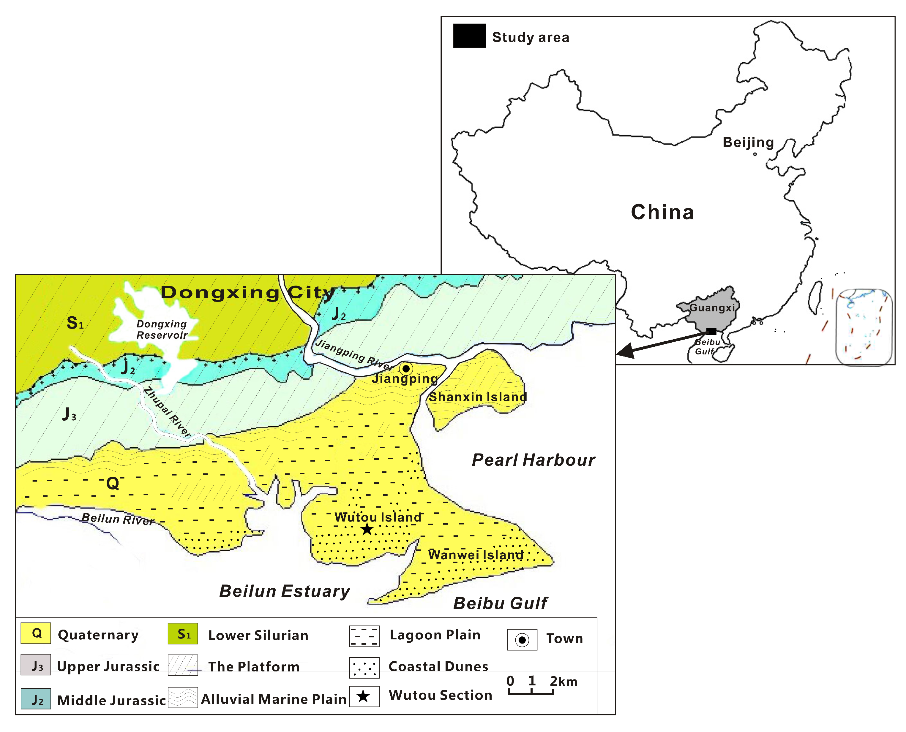
2. Study Area
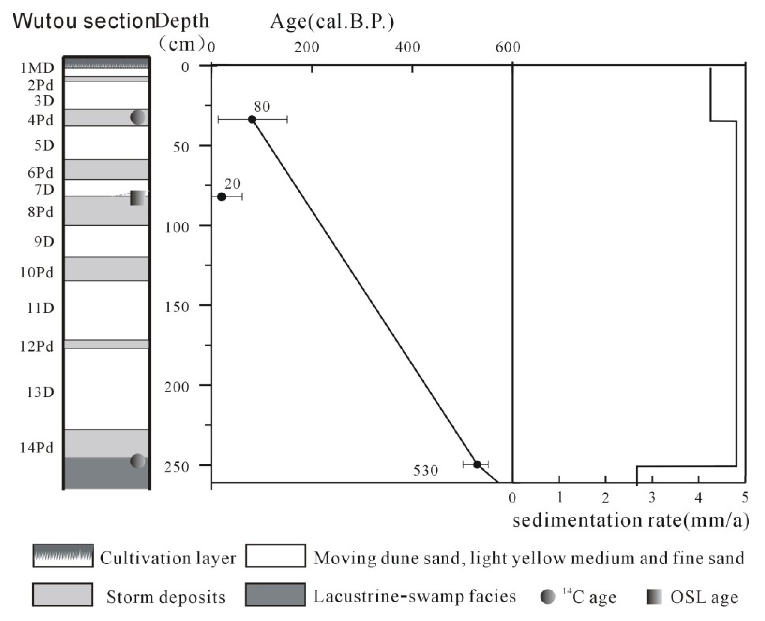
3. Sequence of Aeolian Sand and the Age of the Wutou Section in Jiangping
3.1. Wutou Section
3.2. Chronological Result
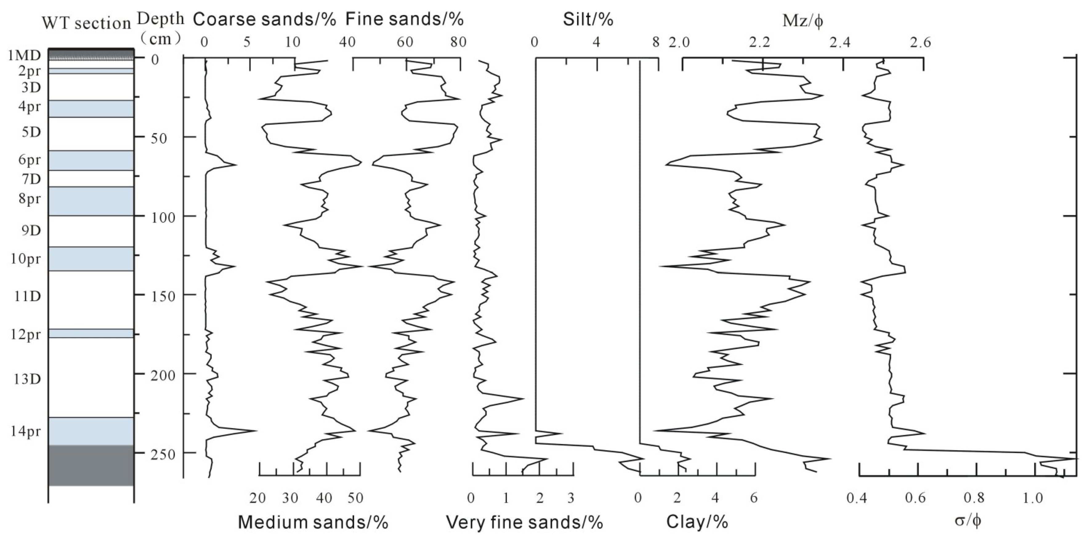
4. Analyses of Particle Sizes and Heavy Minerals of the WTS
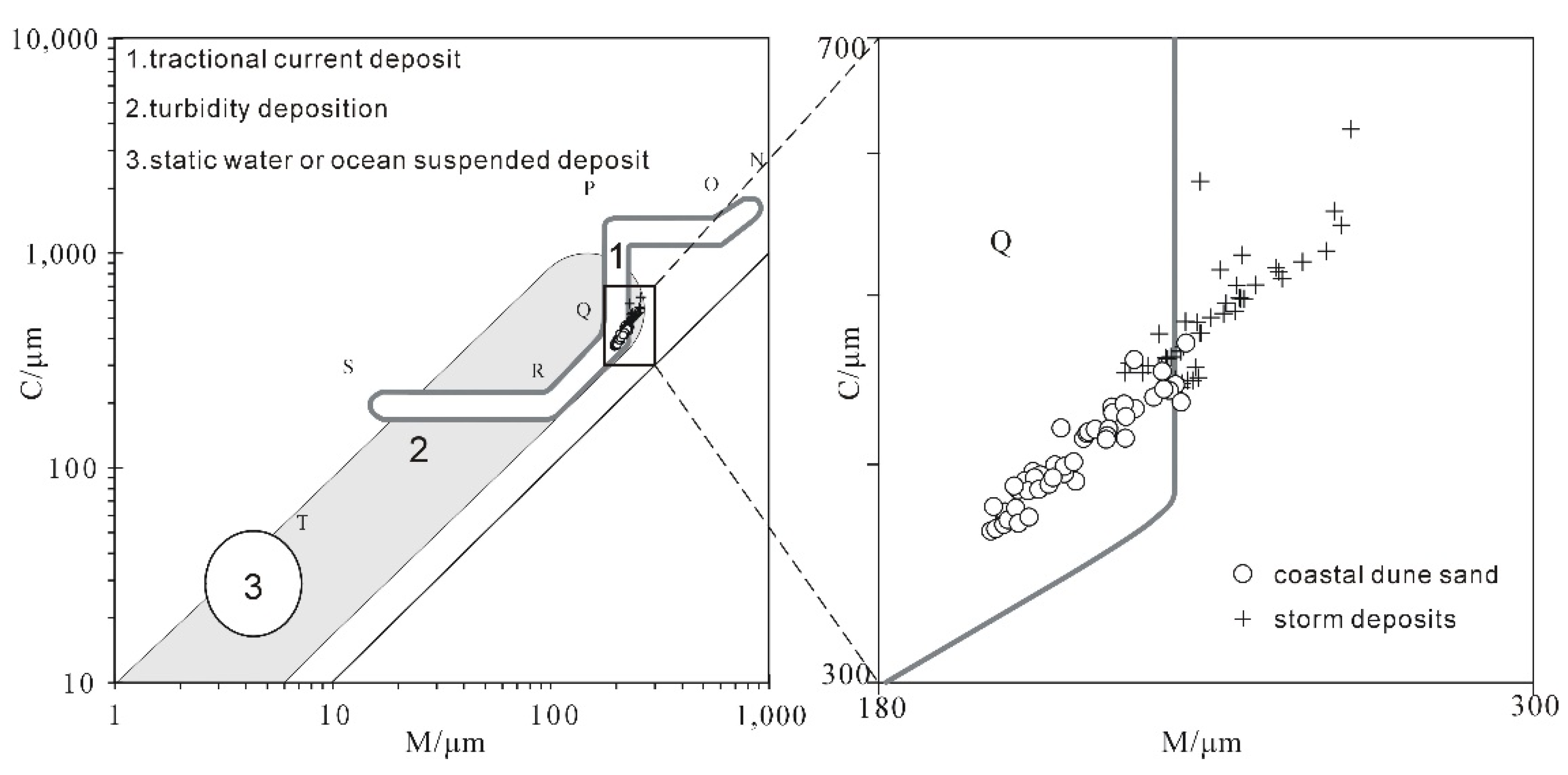
4.1. Particle Size Analysis
4.2. Analysis of Heavy Minerals
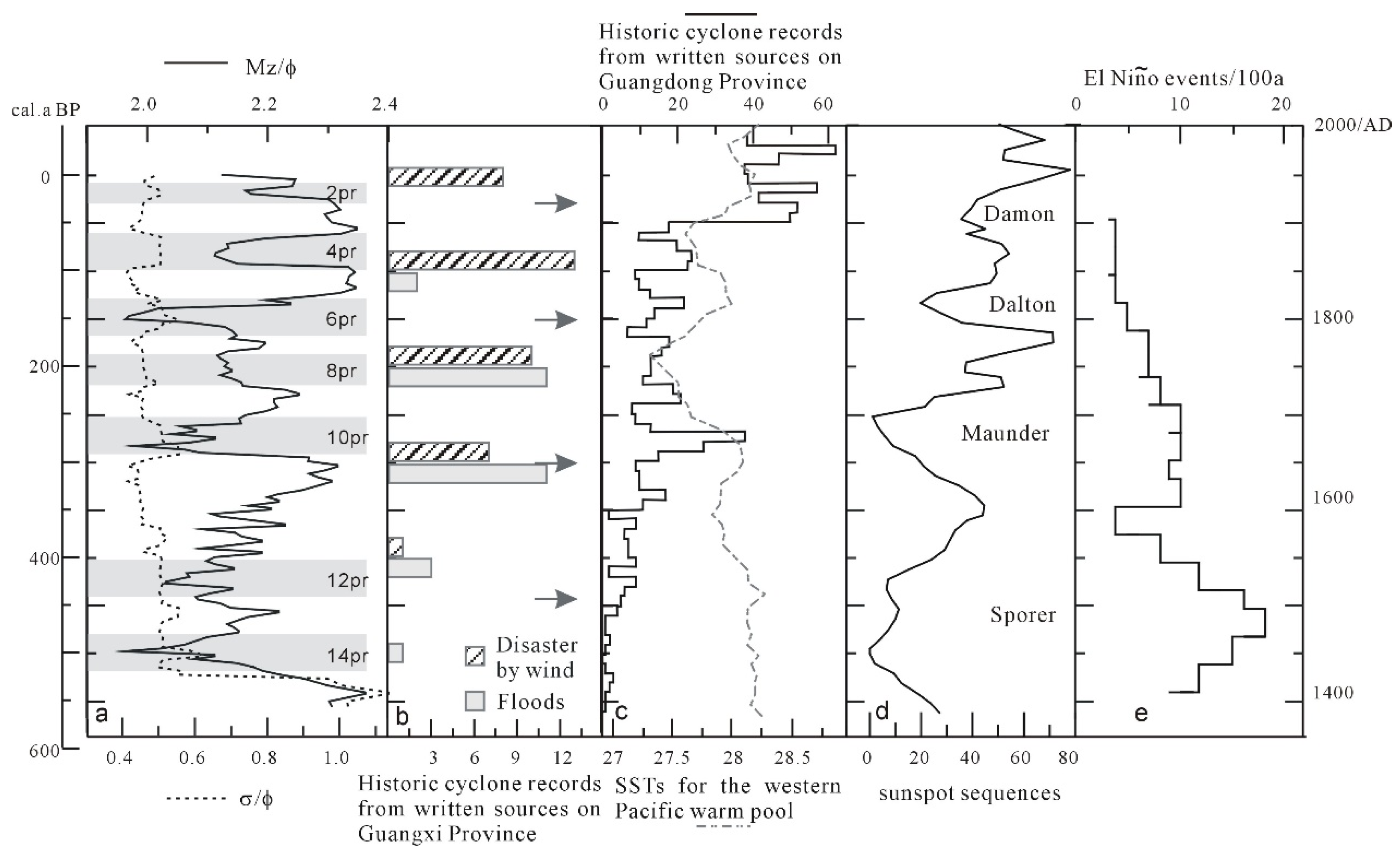
5. Discussion
5.1. Storm Surge Events Indicated by Storm Deposits in the WTS
5.2. Evolution of the Coastal Environmental in the Beibu Gulf since the Late Holocene and the Significance of High-Energy Sea-Atmosphere Events
6. Conclusions
Author Contributions
Funding
Conflicts of Interest
References
- Ying, M.; Zhang, W.; Yu, H.; Lu, X.; Feng, J.; Fan, Y.; Zhu, Y.; Chen, D. An overview of the China Meteorological Administration tropical cyclone database. J. Atmos. Ocean. Technol. 2014, 31, 287–301. [Google Scholar] [CrossRef] [Green Version]
- Emanuel, K. Increasing destructiveness of tropical cyclones over the past 30 years. Nature 2005, 436, 686–688. [Google Scholar] [CrossRef] [PubMed]
- Chan JC, L. Comment on Changes in tropical cyclone number, duration and intensity in a warming environment. Science 2006, 311, 1713. [Google Scholar] [CrossRef] [Green Version]
- Huang, G.; Yan, W. Holocene storm deposits information of the Pearl Estuary indicated by foraminifera. Chin. Sci. Bull. 1997, 42, 423–426. [Google Scholar]
- Xiong, H.; Zong, Y.; Huang, G.; Fu, S. Seabed erosion and deposition related to the typhoon activity of the past millennium on the southeast coast of China. Earth Surf. Process. Landf. 2020, 45, 1695–1704. [Google Scholar] [CrossRef]
- Yu, K.F.; Zhao, J.X.; Collerson, K.D.; Shi, Q.; Chen, T.G.; Wang, P.X.; Liu, T.S. Storm cycles in the last millennium recorded in Yongshu Reef, southern South China Sea. Palaeoecology 2004, 210, 89–100. [Google Scholar] [CrossRef]
- Chen, T.; Roff, G.; Feng, Y.; Zhao, J. Tropical Sand Cays as Natural Paleocyclone Archives. Geophys. Res. Lett. 2019, 46, 9796–9803. [Google Scholar] [CrossRef]
- Chen, H.F.; Wen, S.Y.; Song, S.R.; Yang, T.N.; Lee, T.Q.; Lin, S.F.; Hsu, S.C.; Wei, K.Y.; Chang, P.Y.; Yu, P.S. Strengthening of paleo-typhoon and autumn rainfall in Taiwan corresponding to the Southern Oscillation at Late Holocene. J. Quat. Sci. 2012, 27, 964–972. [Google Scholar] [CrossRef]
- Wang, L.C.; Behling, H.; Lee, T.Q.; Li, H.C.; Huh, C.A.; Shiau, L.J.; Chang, Y.P. Late Holocene environmental reconstructions and their implications on flood events, typhoon, and agricultural activities in NE Taiwan. Clim. Past 2014, 10, 1857–1869. [Google Scholar] [CrossRef] [Green Version]
- Zhou, L.; Gao, S.; Jia, J.; Zhang, Y.; Yang, Y.; Mao, L.; Fang, X.; Shulmeister, J. Extracting historic cyclone data from coastal dune deposits in eastern Hainan Island, China. Sediment. Geol. 2019, 392, 105524. [Google Scholar] [CrossRef]
- Li, H.C.; Zhao, M.; Tsai, C.H.; Mii, H.S.; Chang, Q.; Lee, K.Y. The first high-resolution stalagmite record from Taiwan: Climate and environmental changes during the past 1300 years. J. Asian Earth Sci. 2015, 114, 574–587. [Google Scholar] [CrossRef]
- Chan, J.C.L.; Shi, J.E. Frequency of typhoon landfall over Guangdong Province of China during the period 1470-1931. Int. J. Climatol. 2000, 20, 183–190. [Google Scholar] [CrossRef]
- Liu, K.B.; Shen, C.M.; Louie, K.S. A 1000-year History of Typhoon Landfalls in Guangdong, Southern China, Reconstructed from Chinese Historical Documentary Records. Ann. Assoc. Am. Geogr. 2001, 91, 453–464. [Google Scholar] [CrossRef]
- IPCC. Climate Change 2007, The Physical Science Basis. Contribution of Working Group I to the Fourth Assessment Report of theIntergovernmental Panel on Climate Change; Cambridge University Press: Cambridge, UK, 2007. [Google Scholar]
- Liu, K.; Fan, D. Global warming is causing the typhoon enhancements: Paleotempestology progress and implications. Chin. Sci. Bull. 2008, 53, 1489–1502. [Google Scholar]
- Short, A.D.; Hesp, P.A. Wave, beach and dune interactions in southeastern Australia. Mar. Geol. 1982, 48, 259–284. [Google Scholar] [CrossRef]
- Pye, K. Coastal dunes. Prog. Phys. Geogr. 1983, 7, 531–557. [Google Scholar] [CrossRef]
- Huang, Z. Comparison of the paleodune formed during the late pleistocene between China and Japan. Trop. Geogr. 1993, 13, 1–12. [Google Scholar]
- Wu, Z.; Huang, S.; Hu, S. Research on the Landforms of the Wind-Drift Sand in South China Coast; Science Press: Beijing, China, 1995; pp. 53–56. [Google Scholar]
- Van de Graaff, J. Dune erosion during a storm surge. Coast. Eng. 1977, 1, 99–134. [Google Scholar] [CrossRef]
- Vellinga, J. Beach and dune erosion during storms. Coast. Eng. 1982, 6, 361–387. [Google Scholar] [CrossRef] [Green Version]
- Hesp, P.A. Surf zone, beach and foredune interactions on the Australian south east coast. J. Coast. Res. 1988, 3, 15–25. [Google Scholar]
- Zhang, G.D.; Wang, Y.Y.; Zhu, J.C.; Yan, J.P. Modern coastal storm deposits of Putuo Island and Zhujiajiao Island, Zhoushan. Acta Sedimentol. Sin. 1987, 5, 17–28. [Google Scholar]
- Dong, Y.; Namikas, S.L.; Hesp, P.A.; Ma, J. Field measurements of influence of sand transport rate on structure of wind-sand flow over coastal transverse ridge. Chin. Geogr. Sci. 2008, 18, 255–261. [Google Scholar] [CrossRef]
- Dong, Y.; Du, J. Review on the typhoon effect on coastal aeolian land forms. J. Desert Res. 2014, 34, 634–638. [Google Scholar]
- Yang, L.; Dong, Y.; Huang, D. Morphology and Grain Size of the Near Surface Sediment over Coastal Sand Sheet Response to Typhoon. Sci. Geogr. Sin. 2017, 37, 1243–1250. [Google Scholar]
- Silva, F.G.; Wijnberg, K.M.; Hulscher, S. Storm-induced sediment supply to coastal dunes on sand flats. Earth Surf. Dyn. 2020, 8, 335–350. [Google Scholar] [CrossRef]
- Sallenger, A.H., Jr. Storm impact scale for barrier islands. J. Coast. Res. 2000, 16, 890–895. [Google Scholar]
- Jelgersma, S.M.; Stive, M.J.; Van der Valk, L. Holocene storm surge signatures in the coastal dunes of the western Netherlands. Mar. Geol. 1995, 125, 95–110. [Google Scholar] [CrossRef] [Green Version]
- Cunningham, A.C.; Bakker, M.A.; Van Heteren, S.; Van Der Valk, B.; Van Der Spek, A.J.; Schaart, D.R.; Wallinga, J. Extracting storm-surge data from coastal dunes for improved assessment of flood risk. Geology 2011, 39, 1063–1066. [Google Scholar] [CrossRef]
- Bateman, M.D.; Rushby, G.; Stein, S.; Ashurst, R.A.; Stevenson, D.; Jones, J.M.; Gehrels, W.R. Can sand dunes be used to study historic storm events? Earth Surf. Process. Landf. 2017, 43, 779–790. [Google Scholar] [CrossRef]
- Dougherty, A.J. Prograded coastal barriers provide paleoenvironmental records of storms and sea level during late Quaternary highstands. J. Quat. Sci. 2018, 33, 501–517. [Google Scholar] [CrossRef]
- Li, G.; Qi, F.; Nong, H.; Liao, S. Sedimentary facies sequences and evolutionary process of sedimentary environment of barrier-lagoons in Jiangping area, Guangxi. J. Oceanogr. Huanghai Bohai Seas 1999, 17, 8–18. [Google Scholar]
- Li, C.; Chen, G.; Wang, P. The stratigraphic model of the Late- Quaternary barrier-lagoon depostional systems along the coast of China. Acta Sedimentol. Sin. 1991, 9, 12–19. [Google Scholar]
- Chinese Gulf History Compilation Committee. Chinese Gulf History (Volume 12, Gulf of Guangxi); China Ocean Press: Beijing, China, 1993; pp. 114–176. [Google Scholar]
- Zhang, J. Division and Comparison of Quaternary Strata of Guangxi. Guangxi Geol. 1998, 11, 1–6. [Google Scholar]
- Chen, B.; Qiu, S. Impacts of Typhoon Course and Landform on Water Level Fluctuation in the Coastal Bays in Guangxi. Guangxi Sci. 2000, 7, 282–285. [Google Scholar]
- Reimer, P.J.; Bard, E.; Bayliss, A.; Beck, J.W.; Blackwell, P.G.; Ramsey, C.B.; Buck, C.E.; Cheng, H.; Edwards, R.L.; Friedrich, M.; et al. IntCal13 and Marine13 radiocarbon age calibration curves 0–50,000 years cal BP. Radiocarbon 2013, 55, 1869–1887. [Google Scholar] [CrossRef] [Green Version]
- Duller GA, T.; Murray, A.S. Luminescence dating of sediments using individual mineral grains. Geologos 2000, 5, 87–106. [Google Scholar]
- Mo, Y.; Liao, S.; Ge, W.; Li, P. Primary Analyses of the impacts to Guangxi Coastal Areas by modern sea level rise. Guangxi Sci. 1995, 2, 38–41. [Google Scholar]
- Lu, H.; An, Z. Paleoclimatic significance of loess granularity compositions in Loess Plateau. Chin. Sci. Bull. 1997, 42, 66–69. [Google Scholar]
- Si, Y.; Li, B.; Li, Z. A comparative analysis of grain size characteristics of modern aeolian sand and beach sand from the coast of Beibu Gulf in China. J. Desert Res. 2020, 40, 43–52. [Google Scholar]
- Morton, R.A.; Gelfenbaum, G.; Jaffe, B.E. Physical criteria for distinguishing sandy tsunami and storm deposits using modern examples. Sediment. Geol. 2007, 200, 184–207. [Google Scholar] [CrossRef]
- Folk, P.I.; Ward, W.C. Brazos Reviver bar: A study in the significance of grain size parameters. J. Sediment. Petrol. 1957, 27, 3–26. [Google Scholar] [CrossRef]
- Chen, L.; Zhang, X. Mineral assemblages and their distribution pattern of the sediments from the Beibu Gulf. Acta Oceanol. Sin. 1986, 8, 340–346. [Google Scholar]
- Li, P.; Ye, W. A study on heavy minerals of the surface deposits in the shallow area of Northern Beibu Gulf. Trop. Oceanol. 1987, 6, 39–47. [Google Scholar]
- Kindle, M.E. Dominant factors in the formation of firm and soft sand beaches. Sediment. Pet. 1936, 6, 16–22. [Google Scholar]
- Emery, K.O. Entrainment of air in beach sand. J. Sediment. Petrol. 1945, 15, 39–49. [Google Scholar] [CrossRef]
- Frihy, O.E.; El Askary, M.A.; Deghidy, E.M.; Moufaddal, W.M. Distinguishing Fluvio-Marine Environments in the Nile Delta Using Heavy Minerals. J. Coast. Res. 1998, 14, 970–980. [Google Scholar]
- Hubert, J.F. A zircon-tourmaline-rutile maturity index and the interdependence of the composition of heavy mineral assemblages with the gross composition and texture of sandstones. J. Sediment. Res. 1962, 32, 440–450. [Google Scholar]
- Ren, Z.Y.; Zhao, X.; Liu, H. Dispersion Effects on Tsunami Propagation in South China Sea. J. Earthq. Tsunami 2015, 9. [Google Scholar] [CrossRef]
- Yang, W.; Sun, L.; Yang, Z.; Gao, S.; Shao, D.; Mei, Y.; Zang, J.; Wang, Y.; Xie, Z. Nan’ ao, an archaeological site of Song dynasty destroyed by tsunami. Chin. Sci. Bull. 2018, 63, 1–14. [Google Scholar]
- Wen, K. China Semeteorological Disasters Ceremony: Guangxi Volume; Meteorological Press: Beijing, China, 2006. [Google Scholar]
- Lv, M.; Ding, Y.; Shi, M. The response process of Typhoon China South Sea. Trans. Oceanol. Limnol. 2019, 5, 9–19. [Google Scholar]
- Literature and History Research Museum of Tongzu Autonomous Region of Guangxi. Natural Disaster Historical Materials of Guangxi; The Second Library of Guangxi Zhuang Autonomous Region: Guangxi, China, 1978. [Google Scholar]
- Dongling, L.; Hui, J.; Xiaoqun, X.; Longbin, S.; Tiegang, L. Freshwater diatoms in the Southern Okinawa trough and its implication to typhoon precipitation during the last millennium. Quat. Sci. 2015, 35, 755–766. [Google Scholar]
- Oppo, D.W.; Rosenthal, Y.; Linsley, B.K. 2000-year-long temperature and hydrology reconstructions from the Indo-Pacific warm pool. Nature 2009, 460, 1113–1116. [Google Scholar] [CrossRef] [PubMed]
- Moy, C.M.; Seltzer, G.O.; Rodbell, D.T.; Anderson, D.M. Variability of El Niño/Southern Oscillation activity at millennial timescales during the Holocene epoch. Nature 2002, 420, 162–165. [Google Scholar] [CrossRef] [PubMed]
- Usoskin, I.G.; Solanki, S.K.; Kovaltsov, G.A. Grand minima and maxima of solar activity: New observational constraints. Astron. Astrophys. 2007, 471, 301–309. [Google Scholar] [CrossRef] [Green Version]
- Yu, K.; Chen, T. Beach Sediments from Northern South China Sea Suggest High and Oscillating Sea Levels During the Late Holocene. Earth Sci. Front. 2009, 16, 138–145. [Google Scholar] [CrossRef]
- Fang, G.; Li, P.; Huang, G. Sea level changes in Zhujiang Delta during the past 8000 years. Geogr. Res. 1991, 10, 1–11. [Google Scholar]
- Li, X.; Li, X.; Zhao, Q.; Liu, L.; Zhou, S. The occurrence, acoustic characteristics, and significance of submerged reefs on the continental shelf edge and upper slope, northern South China Sea. Cont. Shelf Res. 2015, 100, 11–24. [Google Scholar] [CrossRef]
- Gray, L.J.; Beer, M.; Geller, M.; Haigh, J.D.; Lockwood, M.; Matthes, K.; Cubasch, U.; Fleitmann, D.; Harrison, G.; Hood, L.; et al. Solar influence on Climate. Rev. Geophys. 2010, 48, 1032–1047. [Google Scholar] [CrossRef]


| Sample | Depth (cm) | Age (a BP) | Calendar Age (cal. A.D.) |
|---|---|---|---|
| WTS4-M | 34 | 120 ± 30(AMS-14C age) | 1940~1880 |
| OSL-7-B | 82 | 20 ± 40(OSL age) | —— |
| WTS15-T | 250 | 500 ± 30(AMS-14C age) | 1448~1398 |
| Site | Facies | Coarse Sand | Medium Sand | Fine Sand | Very Fine Sand | Coarse Silt | Fine Silt | Clay | Mz(Φ) | σ(Φ) | |
|---|---|---|---|---|---|---|---|---|---|---|---|
| WTS | whole section 183 | 0–5.39 | 20.40–50.19 | 46.07–79.11 | 0.02–1.47 | 0–2.78 | 0–1.06 | 0–1.06 | 1.94–2.35 | 0.41–0.62 | |
| average | 0.40 | 36.43 | 62.77 | 0.31 | 0.06 | 0.02 | 0.02 | 2.16 | 0.48 | ||
| aeolian sand layer 92 | 0–1.36 | 20.40–46.55 | 52.05–79.11 | 0.02–1.47 | 0 | 0 | 0 | 2.03~2.35 | 0.41~0.55 | ||
| average | 0.15 | 33.28 | 66.21 | 0.36 | 0 | 0 | 0 | 2.22 | 0.46 | ||
| storm deposits layer | 0.03–5.39 | 34.21–50.19 | 46.07–63.91 | 0.02–1.27 | 0–2.78 | 0–1.06 | 0–1.057 | 1.94–2.22 | 0.45–0.62 | ||
| average | 0.80 | 41.41 | 57.32 | 0.25 | 0.15 | 0.04 | 0.04 | 2.10 | 0.51 | ||
| Jianling in Hainan Island [10] | aeolian sand layer | 23.49 | 52.36 | 24.15 | 0 | 1.50 | 0.68 | ||||
| storm deposits layer | 39.35 | 42.72 | 17.16 | 0.77 | 1.22 | 0.83 | |||||
| Zhoushan Island in Zhejiang(sand dune) [23] | Before typhoon | 2.20 | 0.37 | ||||||||
| After typhoon | 1.97 | 0.45 | |||||||||
| Hatteras Island in southeastern America (sand dune) [43] | Before typhoon | 1.98 | 1.37 | ||||||||
| After typhoon | 1.74 | 1.54 | |||||||||
| Site | Ilmenite | White Titanium | Zircon | Tourmaline | Hematite | Anatase | Rutile | Epidote | Monazite | Others | ||
|---|---|---|---|---|---|---|---|---|---|---|---|---|
| WTS | D | 17.21~50.40 | 13.27~31.71 | 4.71~12.91 | 5.43~17.85 | 0.40~4.48 | 0.93~4.79 | 1.19~2.58 | 0.17~3.45 | 0.169~0.172 | 2.33~4.61 | |
| average | 42.44 | 23.53 | 9.63 | 10.48 | 1.61 | 2.10 | 1.83 | 1.00 | 0.17 | 3.64 | ||
| Pd | 33.83~59.72 | 10.53~38.76 | 5.22~13.82 | 6.51~14.72 | 0.26~6.78 | 0.41~3.07 | 0.86~2.35 | 0.18~0.78 | 0.16~0.17 | 1.47~5.51 | ||
| average | 46.99 | 22.50 | 9.96 | 10.78 | 2.56 | 1.78 | 1.84 | 0.44 | 0.168 | 3.25 | ||
| Gold beach | 28.05~29.03 | 33.63~39.30 | 9.40~9.60 | 5.75~7.47 | 1.00~1.70 | 7.55~8.10 | 2.30~2.70 | 0.83~1.50 | 1.75~5.17 | |||
| average | 28.54 | 36.47 | 9.50 | 6.61 | 1.35 | 7.83 | 2.5 | 1.17 | 3.46 | |||
| Beibu Gulf [45,46] | average | 55.80 | 23.10 | 38.70 | 10.80 | |||||||
| 56.00 | 12.20 | 9.5 | 10.60 | 4.30 | 4.15 | 0.60 | 1.70 | 1.20 | ||||
| Fangcheng River [45,46] | average | 75.40 | 49.80 | 4.30 | 2.60 | 3.00 | ||||||
| 50.00 | 6.00 | 7.00 | 6.00 | 18.00 | ||||||||
Publisher’s Note: MDPI stays neutral with regard to jurisdictional claims in published maps and institutional affiliations. |
© 2021 by the authors. Licensee MDPI, Basel, Switzerland. This article is an open access article distributed under the terms and conditions of the Creative Commons Attribution (CC BY) license (https://creativecommons.org/licenses/by/4.0/).
Share and Cite
Chen, Z.; Li, B.; Wang, F.; Du, S.; Niu, D.; Zhao, Y.; Si, Y. Evolution of Storm Surges over the Little Ice Age Indicated by Aeolian Sand Records on the Coast of the Beibu Gulf, China. Water 2021, 13, 1941. https://doi.org/10.3390/w13141941
Chen Z, Li B, Wang F, Du S, Niu D, Zhao Y, Si Y. Evolution of Storm Surges over the Little Ice Age Indicated by Aeolian Sand Records on the Coast of the Beibu Gulf, China. Water. 2021; 13(14):1941. https://doi.org/10.3390/w13141941
Chicago/Turabian StyleChen, Zhi, Baosheng Li, Fengnian Wang, Shuhuan Du, Dongfeng Niu, Yinjun Zhao, and Yuejun Si. 2021. "Evolution of Storm Surges over the Little Ice Age Indicated by Aeolian Sand Records on the Coast of the Beibu Gulf, China" Water 13, no. 14: 1941. https://doi.org/10.3390/w13141941