Article

Dealing with the Understanding of the Dynamics Related to Multifactorial Temporal Interactions That Spatially Affect the Landscape of Coastal Lagoons

by
Ana I. Casarrubias-Jaimez
1,
Ana Laura Juárez-López
1,
Efraín Tovar-Sánchez
2,
José Luis Rosas-Acevedo
1,
Maximino Reyes-Umaña
1,
América Libertad Rodríguez-Herrera
1 and
Fernando Ramos-Quintana
2,*
1
Regional Development Science Center, Universidad Autónoma de Guerrero, Acapulco 39640, Mexico
2
Biodiversity and Conservation Research Center, Universidad Autónoma del Estado de Morelos, Cuernavaca 62209, Mexico
*
Author to whom correspondence should be addressed.
Water 2021, 13(15), 2099; https://doi.org/10.3390/w13152099
Submission received: 21 June 2021 / Revised: 26 July 2021 / Accepted: 28 July 2021 / Published: 31 July 2021

Abstract

:
Models based on multifactorial interactions are needed to deal with the dynamics taking place in the eutrophication processes of coastal lagoons. However, as the number of indirect drivers stemming from anthropogenic factors increases, temporal disorders between anthropogenic activities may increase, thus hindering the understanding of their dynamics. We have built multifactorial pathways to deal with the dynamics associated with the cultural eutrophication process of a coastal lagoon. The pathways guided the identification of potential temporal disorder patterns between anthropogenic activities, which may exert influence on the disturbances associated with eutrophication process. The identification of temporal disorder patterns derived from anthropogenic activities belonging to different pathways resulted in a valuable form of support for analyzing and evaluating relationships between public policies, technological skills and environmental culture programs. All of which exert influence on the eutrophication process, which in turn cause changes on the trophic state and on the landscape of the coastal lagoon. Pathways composed of multifactorial interactions that take into account spatial and temporal aspects, contribute to improving the understanding of the inherent dynamics of the eutrophication process of coastal lagoons. Temporal disorders between anthropogenic activities may be seen to emerge, thus exerting changes on the trophic state and spatial damage on the landscapes of coastal lagoons.

1. Introduction

Complex patterns in both time and space domains stem from ecosystems, such as coastal lagoons. The study of inherent dynamics of such ecosystems may provide insight into the understanding of how patterns are produced. Spatiotemporal models based on mathematical and computational models are useful supports for understanding the dynamics associated with ecological systems [1]. The understanding of spatiotemporal patterns of variations depends on the scale at which patterns are observed [2,3,4,5], which should include driving forces, impacts, processes and responses, to be properly addressed for the sake of the development of environmental management systems [6].
The spatiotemporal richness patterns of species and the processes that drive them should be studied simultaneously to improve the understanding of such patterns [2]. Based on this argument, we consider that the eutrophication process drives the spatial and temporal patterns in coastal lagoons, thus affecting the trophic state of the lagoon, which in turn exerts effects on the species richness, such as the mangroves, the flora and fauna of the waterbody, and the green areas, among others.
Anthropogenic activities may cause disturbances on landscapes. Nevertheless, this relationship has been poorly studied and, consequently, little understood [7].
The water quality of the Beichuan river in China was monitored using spatiotemporal patterns to identify the distribution of pollution sources and quantify the spatial and seasonal variations [8]. Spatiotemporal patterns related to the mineralization process caused by organic matter derived from sediments generated by human activities were identified as important factors that affect the trophic state of waterbodies along the French Atlantic coast [9].
The runoffs from agriculture activities are an important source of pollution [10]. Spatiotemporal patterns were used to determine the water quality of the Saigon-Dong Nai river that runs through urban and industrial areas, which were found to be the main sources of water pollution [11]. Seasonal patterns of the chemical water composition were identified in the Double Mountain Fork Brazos river, as well as the ichthyotoxicity. It was found that this waterbody is mainly polluted by water wastes localized within urban and rural areas [12].
Henneman and Petruccio assessed the spatiotemporal dynamic of trophic states through water parameters of coastal lagoons in South Brazil [13]. Spatiotemporal patterns were evaluated to determine the variations of physicochemical parameters in the Taihu lake derived from contamination sources stemmed from agricultural, industrial, and domestic activities [14].
An analysis aimed at identifying spatiotemporal patterns in water pollution is not always focused on the water pollution itself, but on the interactions between indirect drivers (population growth, economic growth, and technology) that cause water pollution [15]. It is suggested to improve the understanding of the spatiotemporal variation patterns of water pollution to better support the decision-making process aimed at developing targeted and effective water pollution control policies.

The Importance of Conceptual Frameworks in These Studies

As we can see, both anthropogenic and natural factors may be involved in spatiotemporal patterns associated with the processes that determine the richness of species, landscape and ecosystem changes, and the quality of water bodies, among others. Both driving force factors and pressure factors play significant roles in the assessment of the state of ecosystems, such as coastal lagoons. As a result, low quality states of ecosystems cause impacts that usually damage human wellbeing. The multiple interactions between driving force and pressure factors lead to complex systems, which are usually hard to understand and consequently hard to evaluate. Both the understanding and evaluation of complex systems, such as coastal lagoons, underpin the decision-making processes aimed at selecting adequate management actions to improve the state quality of ecosystems. The sequence of events related to the understanding of the inherent dynamic of a complex system, the assessment of its state and their impacts, and the decision-making process to select adequate management actions, require conceptual frameworks capable of guiding the accomplishment of such a sequence. These conceptual frameworks may result in valuable support for decision-makers and stakeholders in environmental or ecosystem management. The DPSIR (Driving-Force, Pressure, State, Impact and Response) is a conceptual framework that has been used as a valuable support in the study of environmental management systems and the management of ecosystems [16,17,18,19,20].
The DPSIR framework has also been applied to the studies of spatiotemporal patterns related to ecosystems that provide benefits to human beings. The ecosystem assessments provide valuable information to understand their contribution to human wellbeing and thus supporting policy and management actions. The DPSIR application aided to highlight the need for the integration of drivers and pressures in ecosystem assessments, by using empirical data at relevant spatiotemporal scales, for supporting the development of more dynamic and management practices for the Mediterranean Basin [21].
The DSPIR framework guided the description of the dynamics of spatiotemporal patterns in the ecosystem services related to the anthropogenic activities, which is used to support environmental management of the basin of the Urmia Lake, Iran [22]. Spatiotemporal dynamics studies to evaluate water resources were carried out in 18 cities of Henan Province, China from 2006 to 2015. The DPSIR framework was used to construct an index system composed of 21 indices for measuring if the water resources can support the local coordinated development of population, economy, and environment towards a sustainable utilization [23]. The DPSIR has the capacity to facilitate the transmission of meaningful information on environmental issues to stakeholders and policy makers by promoting information exchange and comparison of spatial and temporal patterns [24].
Despite the applicability of the DPSIR framework to spatiotemporal patterns, environmental problems and ecosystems, some shortcomings related to this framework have been identified. One of these disadvantages is related to its low capacity to support the understanding of the dynamic of ecosystems, such as coastal lagoons. This aspect is associated with its lack of representation of factors at several levels of abstraction, which is useful for linking driving-force factors with pressure factors [25,26]. This shortcoming is even more critical when an ecosystem is modeled by taking into account indirect drivers associated with sociopolitical, socioeconomic, demographic, technological, and cultural factors, which in turn should be linked to intermediate and final pressure factors to represent and assess, as close as possible, the state of real situations.
In order to address the problem mentioned above, in this work we propose a framework that links indirect and direct drivers represented at several levels of abstraction to represent factors that exert influence or cause effects on the eutrophication process of a coastal lagoon. The linkage between indirect and direct drivers will be represented by a set of pathways composed of sequences of relationships between pairs of factors. Derived from pathways, we have identified temporal patterns represented by incorrect temporal coordination between anthropogenic factors (indirect drivers) that cause disorders thus exerting effects on the eutrophication process; the spatial landscape is mainly affected by mangrove loss.
In this work we will deal with the problem of the cultural eutrophication process (CEP). Therefore, we first provide some definitions of the eutrophication process and then definitions of the cultural eutrophication process. The eutrophication of water bodies is recognized as a problem of disturbance, consequently, causes and effects due to disturbances are produced through a process, which in this case is called the eutrophication process. The eutrophication process may occur either through natural causes or as a result of human activities and/or events, such as human settlements, which generate activities that damage the trophic state of water bodies [27,28,29,30,31,32,33,34,35].
The following two definitions match the approach treated in this work: (1) “Eutrophication means enhanced primary production due to excess supply of nutrients from human activities, independent of the natural productivity level for the area in question” from the European Environmental Agency [36]; (2) “Eutrophication is defined as an environmental disturbance caused by excessive supply of organic matter” from the United Nations Environmental Programme [37]. We consider that human activities are responsible for supplying an excess of nutrients and we address the eutrophication as an environmental disturbance.
The concept of cultural eutrophication has been incorporated as a process mainly derived from anthropogenic activities, such as deforestation [38], the use of fertilizers in agriculture [39], and nitrogen emissions [40], among the most important, all of them contributing to trophic state changes in water bodies. The natural landscapes of coastal lagoons are enjoyed by humans; thus, tourist activities contribute significantly to the CEP [41,42,43,44,45].
The spatial effects are mainly related to mangrove damage, the change of land use due to human settlements, and to the trophic state. The temporal approach may provide insights into the understanding of how the implementation of certain anthropogenic activities without a temporal order may influence the CEP and consequently the conservation of certain species, the quality of human settlements and the trophic state. In conclusion, we deal mainly with temporal disorders associated with interactions between anthropogenic activities represented by different factors that exert effects on the eutrophication process, which in turn may cause spatial effects represented by landscape changes of the coastal lagoons.

2. Materials and Methods

2.1. Materials

This research is applied to the Tres Palos coastal lagoon, which is located in the southeast part of the Acapulco Municipality, on the Pacific Ocean coast, in the state of Guerrero, Mexico (see Figure 1 below). This lagoon covers an area of 55 km2. Its average depth is 3.43 m during the dry season and 7 m during the rainy season. It is fed by the Rio de la Sabana and communicates with the sea through a meandering channel of 12 km that ends in the town of Barra Vieja.

2.2. Methods

Before dealing with the methods proposed in this work, we introduce important definitions of key concepts to be used in this section. Such concepts are: levels of indirect and direct drivers, which have been defined based on their functional roles within the context of the eutrophication process; relationships between factors; pathways; multifactorial network, and temporal disorders.

2.3. Important Definitions

Indirect Drivers. These factors are associated with anthropogenic activities that exert influence on the eutrophication process, thus causing changes on the trophic state of the coastal lagoon, as well as on its landscape.
Direct Drivers. These are activities associated with the eutrophication process through factors capable of generating tangible chemical products, thus causing effects on the trophic state of the coastal lagoon, as well as on its landscape.
Levels of Indirect and Direct Drivers based on their Functional Roles. We propose a novel classification of indirect and direct drivers at several levels based on their functional roles in the eutrophication process. Indirect drivers represent factors related to anthropogenic activities that do not generate tangible harmful products that lead to changes in the trophic state but exert an important influence on the eutrophication process. Meanwhile, direct drivers represent factors able to generate tangible harmful products capable of changing the trophic state. The number of levels depends on the process to be studied. For the purpose of this work, three levels have been defined for both indirect and direct drivers.
Level-I of Indirect Drivers. They are represented by a set of anthropogenic concepts related to Demographic (population increase), Socioeconomic, Sociopolitical, Technological, and Environmental Cultural factors. Factors and their acronyms: Population increment (Pop-Increase); Socioeconomic (SocioEco); Sociopolitical factors, mainly represented by public policies (PP); Technological skills (Tech); Environmental Culture (Cult).
Level-II of Indirect Drivers. These drivers represent specific anthropogenic activities from which we can identify the possible sources of chemical components produced during the eutrophication process. Such anthropogenic activities are related to human settlements (around the lagoon and along the river), tourism, and those related to industrial activities. Factors and their acronyms: Human settlements around the lagoon and river (HumSetL, HumSetR); Tourism; River Industry.
Level-III of Indirect Drivers. At the third level, we can verify that the production of waste, sewage-sludge, and other harmful products stem from regular or irregular human settlements, along the river or around the lagoon; the consumption of products due to factors associated with the tourism, thus contributing to the generation of wastes. However, up to this level, we cannot affirm that Level-III Indirect Drivers produce tangible harmful material affecting the trophic state of the coastal lagoon. Factors and their acronyms: Irregular human settlements around the lagoon (IrrHumSetL); Regular human settlements around the lagoon (RegHumSetL); Irregular human settlements along the river (IrrHumSetR); Regular human settlements along the river (RegHumSetR); Product Consumption (ProdConsum).
Level-III of Direct Drivers. At this level of direct drivers, we can already identify activities, such as agriculture and the generation of solid urban waste from the river or lagoon, as harmful products. Factors and their acronyms: Agriculture around the lagoon (IrrAgricL); Generation of solid urban waste from the lagoon (GenSolUrbWasL); Consumption of mangrove resources (ConsMangRes); Generation of special handling waste from the river (GenSpecHandWasteR); Irregular Agriculture along the river (IrrAgriR); Water treatment plants (WaterTreatPlant); Generation of solid urban wastes from the river (GenSolUrbWasteR).
Level-II of Direct Drivers. At this level, the generation of sediments, solid and liquid wastes, and phosphorous and nitrogen loads take place. Factors and their acronyms: Sediments from lagoon and river (LagSediments, RivSediments); Solid waste from lagoon and river (SolWasteL, SolWasteR); Liquid waste from lagoon and river (LiqWasteL, LiqWasteR); Mangrove Loss (MangroveLoss); Filtering Effect for Waste Reduction (FEWasteRed).
Level-I of Direct Drivers. Finally, chemical components such as nitrogen and phosphorous, contribute to directly determine the trophic state of the coastal lagoon. Factors and their acronyms: Phosphorous load from lagoon and river (PhosloadL, PhosloadR); Nitrogen load from lagoon and river (NitroloadL, NiroloadR); Sum liquid and solid waste from lagoon and river (Sum(LiqSolWasteL), Sum(LiqSolWasteR); Sum of P and N from the lagoon and river (Sum(Nitro,Phos)L, Sum(Nitro,Phos)R).
Relationships between Factors. In complex systems, such as the one associated with a coastal lagoon, multiple interactions between factors determine their dynamics to a large extent. Such interactions can be represented by cause-effect relationships or influence relationships where one factor exerts influence on the activity of others. A formal expression for a relationship is as follows: A→B, which means “A causes effects on B” or “A exerts influence on B”. In this case, A represents the effector node and B the receptor node.
Pathways. A pathway is defined as a sequence of relationships that link Level-I indirect drivers with Level-I direct drivers. We have to highlight that Level-I indirect drivers and Level-I direct drivers are located at the beginning and the end of the pathway, respectively.
Temporal Disorders. In specific key nodes, belonging to direct driving factors, the support of three human factors is required (public policies, technological skills, and cultural programs) to reduce, regulate, and/or control the effects of the eutrophication process. In this work, we label these nodes as “key nodes”. We have identified patterns characterized by erroneous temporal coordination or a bad formulation of relationships that represent the interactions between key nodes and the anthropogenic factors mentioned before. This erroneous coordination brings about temporal disorders that exert influence on the eutrophication process, thus affecting the trophic state and the spatial landscape of the lagoon.

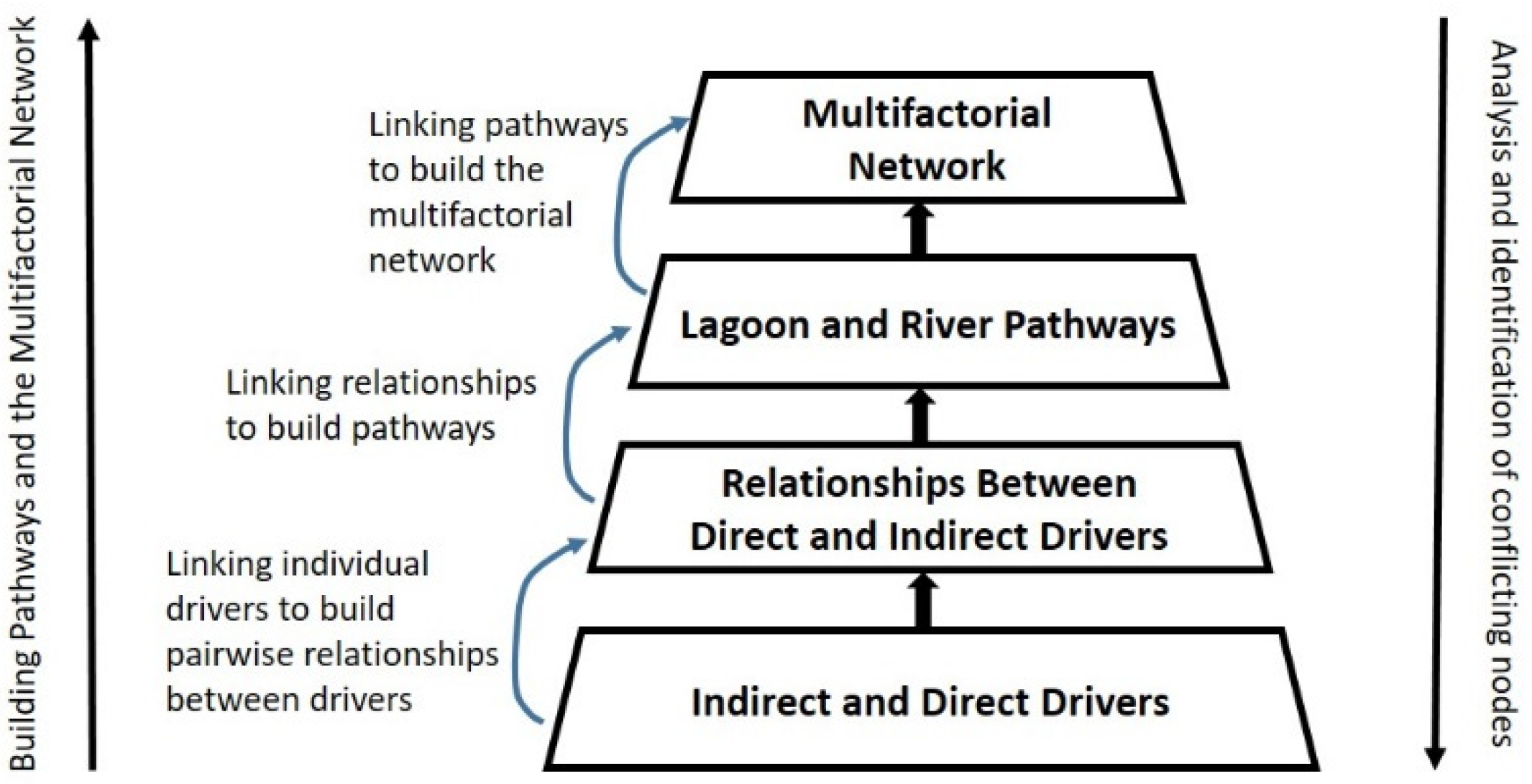
2.4. The Bottom-Up/Top-Down Approach

We have developed a bottom-up method to build pathways and the multifactorial network related to the lagoon and the river. Meanwhile, a top-down method is used to analyze and identify key nodes where temporal disorders may take place. Figure 2 shows a pyramid, where the bottom-up and top-down methods are described.

2.5. Building the Pathways of the Lagoon and the River: The Bottom-Up Method

The bottom-up method is composed of the following levels: (i) at the bottom level, the individual factors are defined. Such factors are related to both direct and indirect drivers. These factors are described in the subsection related to the important definitions; (ii) at the second level, pairwise relationships between direct and indirect drivers are built. Two main forms of relationships are used in this work: the cause-effect relationships and the relationships that express the influence exerted by a factor on other factors; (iii) at the third level, the lagoon and river pathways are built by linking relationships; (iv) at the top level, the pathways of the lagoon and river are linked to build the multifactorial networks related to the lagoon and to the river.
Figure 3 shows the pathways related to the lagoon. The key nodes of the lagoon pathways are in yellow color. Meanwhile, Figure 4 shows the pathways related to the river. The key nodes of the river pathways are in green color.
The set of pathways belonging to the lagoon and river facilitates the analysis of the dynamics associated with the cultural eutrophication process.

2.6. Identifying the Key Nodes from the Pathways: The Top-Down Method

The top-down method is used to analyze and identify key nodes of the pathways that may bring about disorders due to erroneous temporal coordination between the following anthropogenic activities: sociopolitical (public policies), technological skills, and environmental culture programs. This erroneous coordination may bring about temporal disorder patterns that may exert influence on the eutrophication process.
The key nodes of the lagoon pathways (see Figure 3) belong to the categories of direct drivers: IrrAgricL, GenSolUrbWasL and ConsMangRes. These key nodes require the support of public polices, technological skills, and environmental culture programs, which should be submitted to temporal coordination. Otherwise, temporal disorders may emerge, thus hindering the purpose of regulating and/or controlling activities associated with the eutrophication process that may cause changes on the trophic state and on the landscape of the coastal lagoon.
Meanwhile, the key nodes of the river pathways are shown in Figure 4. They belong to the categories of direct drivers: GenSpecHandWasteR, IrrAgriR, WaterTreatPlant, and GenSolUrbWasteR. These key nodes also require a temporal coordination between public polices, technological skills, and environmental culture programs to ameliorate their performance.

3. Analysis and Discussion of Results

The understanding of the inherent dynamics of the cultural eutrophication process leads to confirm that the anthropogenic activities may contribute to the disturbances associated with this process. The understanding and assessments are key elements to support the decision-making processes, which in turn will support the construction of adequate plans aimed at coordinating and synchronizing activities to reduce damage to the coastal lagoon.
The lack of planning the environmental management activities aimed at reducing or controlling the effects brought about by the cultural eutrophication process may cause temporal disorders, which are mainly characterized by incorrect synchronization between such activities. We have identified patterns derived from a nexus composed of indirect drivers that aim at reducing, regulating or controlling factors that may exert influence on the eutrophication process. Such indirect drivers are related to public policies, technological skills, and environmental culture programs.
The new classification of indirect and direct drivers has three practical advantages: (1) It facilitates the link between indirect and direct drivers; (2) it facilitates the construction of pathways which serves as support to facilitate the understanding and interpretation of particular relationships that link indirect drivers with direct drivers; (3) the use of pathways is an important support to identify those relationships mainly associated with anthropogenic activities that may bring about temporal disorders, thus exerting influence on the disturbances associated with the eutrophication process.

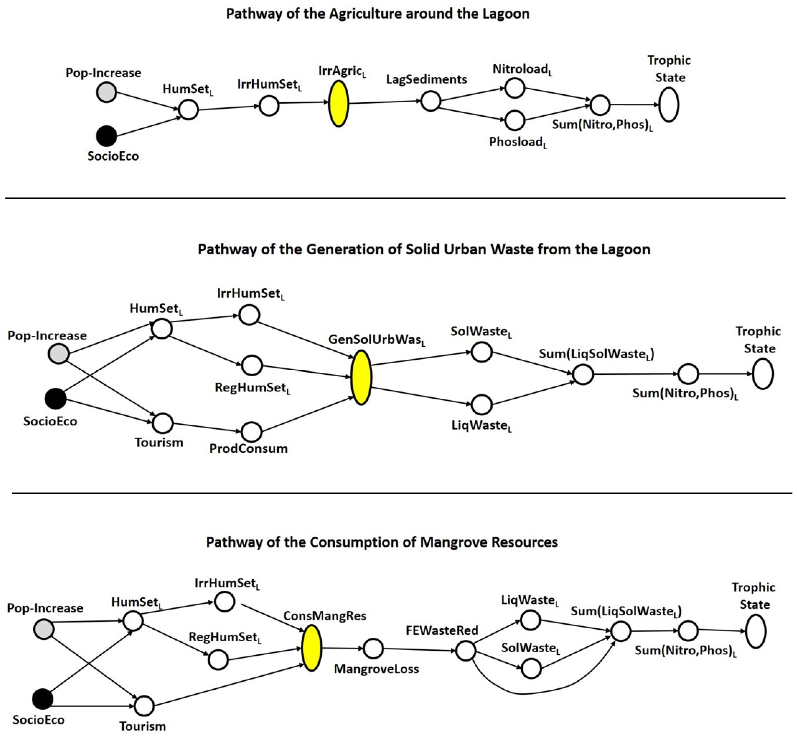
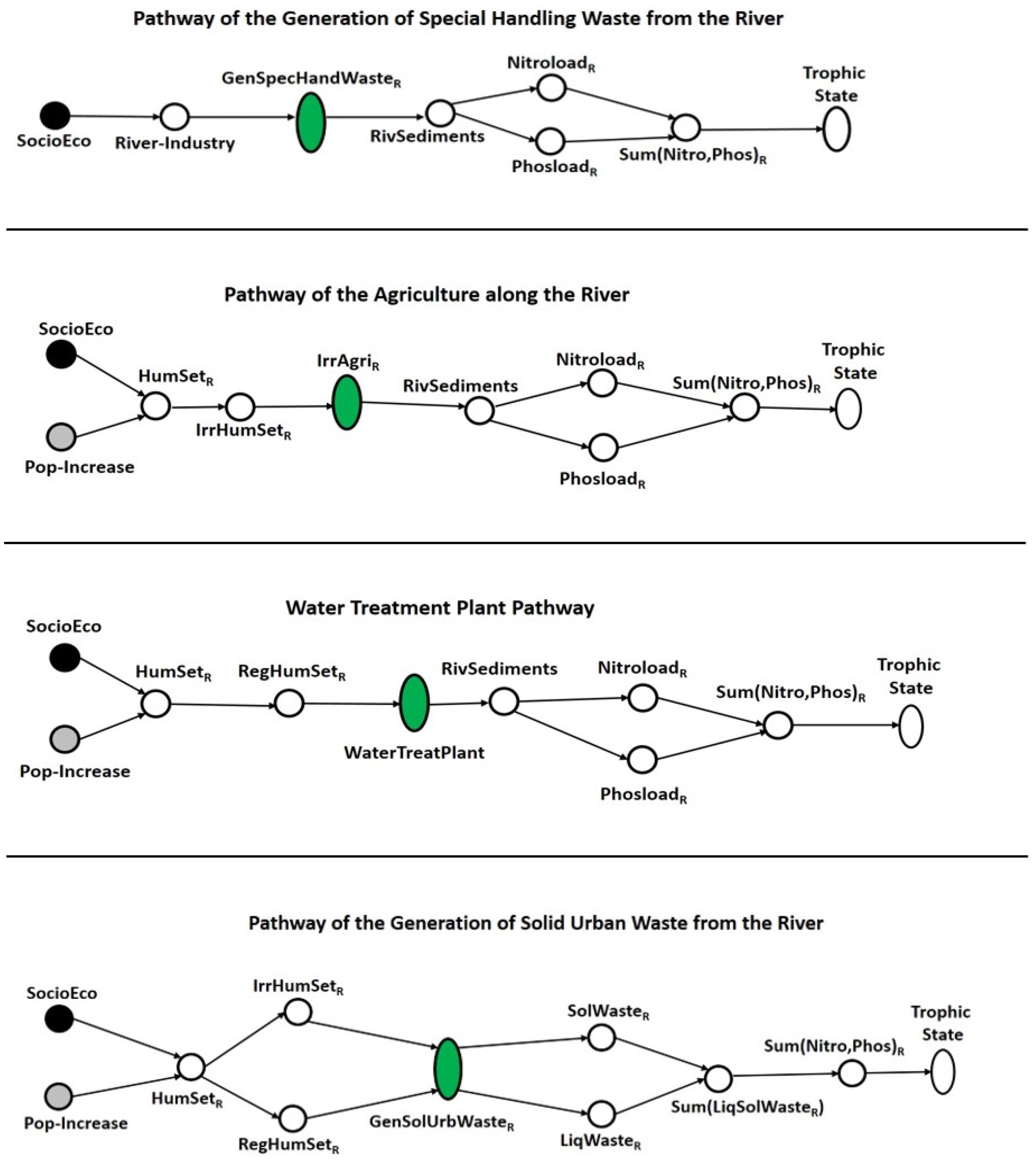
3.1. Analysis and Identification of Key Nodes of Pathways

Overlooking or disregarding irregular agricultural activities, irregular human settlements, the incorrect functioning of wastewater treatment plants, and the consumption of mangrove resources, among the most important elements, hinder the reduction of disturbances associated with the eutrophication process. Consequently, the nodes associated with these activities deserve special attention. These nodes have been labeled as key nodes.
We analyze the temporal disorders for the case of two key nodes: the ConsMangRes node that represents the consumption of the mangrove resources, meanwhile the WaterTreatPlant node is related to the water treatment plants. The lack of data related to the other key nodes prevents their analysis.

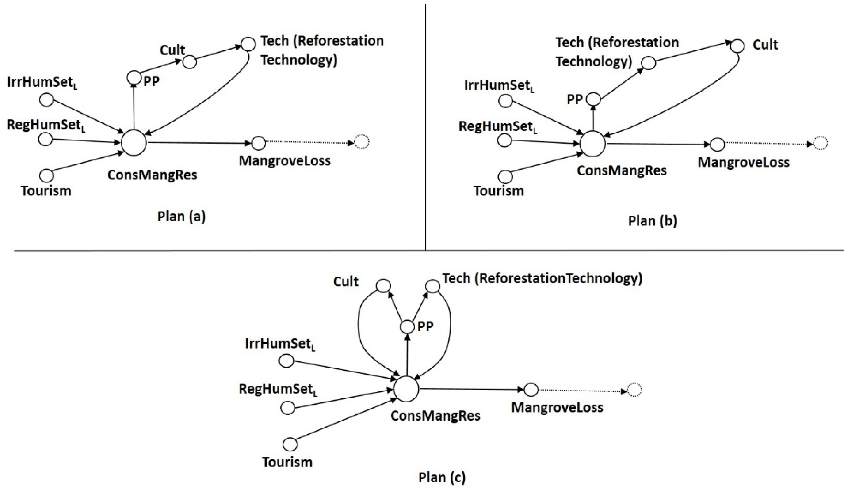
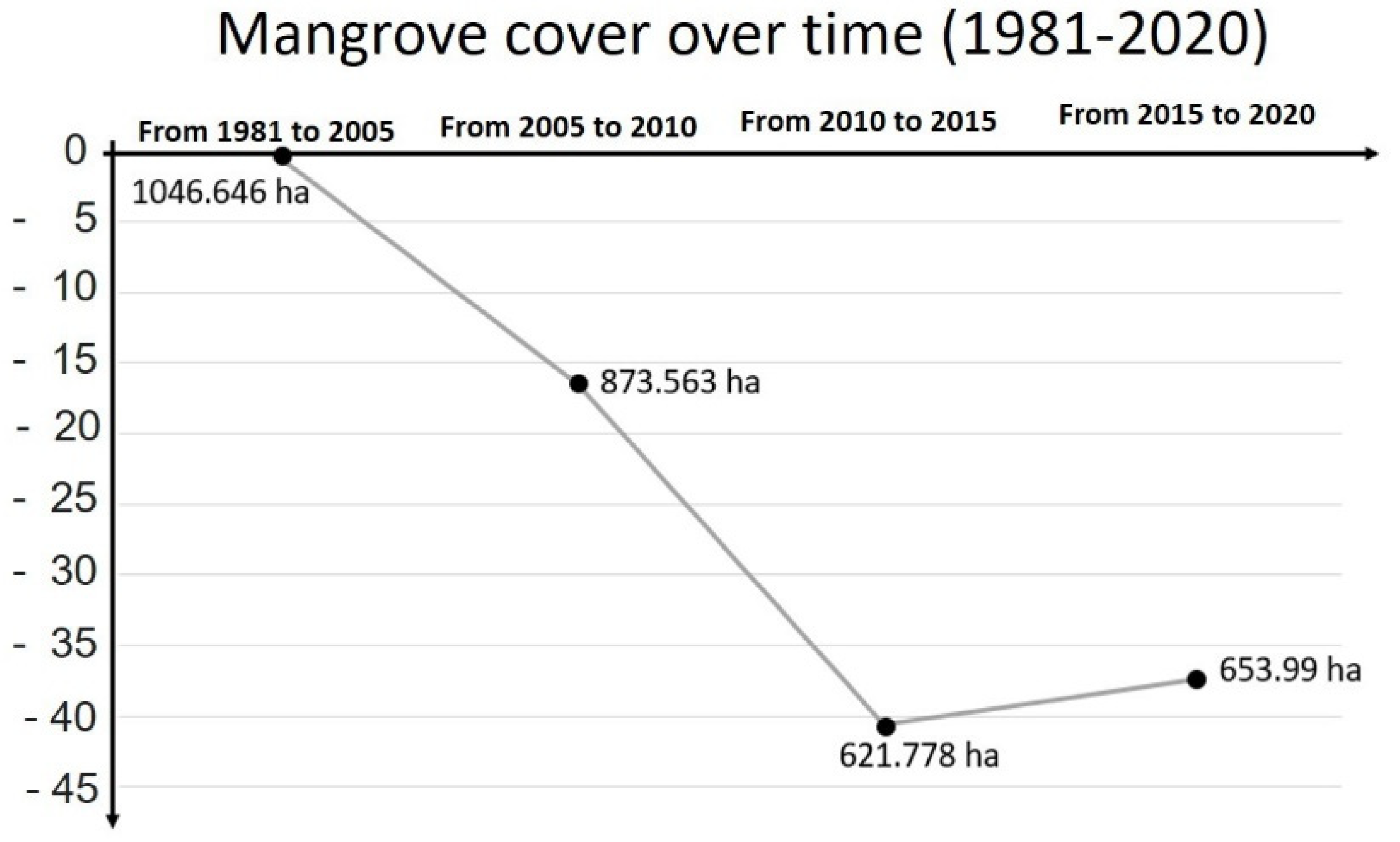
3.2. The Case of the Consumption of the Mangrove Resources (ConsMangRes Node)

Due to the fact that the mangrove plays the role of a natural filter, it retains important loads of liquid and solid waste. Thus, as the mangrove loss increases, less solid and liquid wastes are retained.
It is clear that the mangrove loss requires the implementation of actions derived from the nexus (public policies, technological skills, and environmental culture programs) to reduce, control, or regulate the consumption of mangrove resources. Thus, an action plan should be built to coordinate the actions to be implemented to avoid temporal disorders that may influence and contribute to the disturbances of the eutrophication process.
Two types of action plans are considered: preventive plans and corrective plans. For the purposes of this work, we have defined preventive and corrective plans as follows: a preventive plan is composed of actions aimed at keeping a harmful event from occurring; a corrective plan is composed of actions aimed at reducing damages caused by a harmful event. The harmful event in this case is represented by the relationship between the consumption of mangrove resources and the mangrove loss.
We deal in this work with corrective plans aimed at reducing or controlling the consumption of the mangrove resources by using the components of the nexus as receptors and the ConsMangRes node taking the role of an effector. The ConsMangRes node brings about public policies (PP) aimed at regulating the consumption of the mangrove resources; the environmental culture programs for supporting a change of mentality in the users of the lagoon, aimed at respecting and conserving nature, and the technological skills, such as reforestation expertise, will help to recover the mangrove resources.
In the corrective Plan (a) (see Figure 5 below), in the relationship (ConsMangRes→PP), the key ConsMangRes node plays the role of an effector that leads to a public policy (PP node) being implemented which, in this case, plays the role of a receptor. Following this sequence, in the relationship (PP→Cult), PP plays the role of an effector that brings about the implementation of an environmental culture program which, in this case, plays the role of a receptor. In the next relationship, the Cult node would cause the implementation of a reforestation technology as shown by the following formulation (Cult→Tech). Finally, the link between the implementation of the reforestation technology and the key ConsMangRes node represents a feedback to verify the performance of this plan. Based on the analysis of this corrective plan (Plan (a) in Figure 5 below), we note that an environmental culture program takes place before the reforestation activities. From the point of view of the people’s perception, the fact of knowing, following, and participating in the process of reforestation produces an effect that wakes up the sense of ownership of the project. Otherwise, the environmental culture programs will be overlooked without any impact on the population. The analysis of this pattern shows that an incorrect sequence of corrective actions represents a temporal disorder represented by an incorrect coordination, where the environmental culture activities may turn out to be fruitless, thus putting at risk the efforts invested in the reforestation actions.
Plan (b) of Figure 5 above, a reforestation project of the mangroves of the Tres Palos coastal lagoon took approximately 5 years (2008 to 2013). However, this plan does not take advantage of the period during which the reforestation took place. During this long period, several activities related to the environmental culture program should have been carried out to learn why, when and how reforestation activities are needed for the benefit of human beings. However, patterns of this type are associated with the lack of adequate planning actions, where the implementation of activities belonging to the nexus are temporally incoherent.
Plan (c) (see Figure 5) shows the coordination of the activities associated with the nexus that are adequate for the sake of a correct and coherent temporal coordination. In this case, the public policies (PP node) represent an effector that leads to a simultaneous implementation of the reforestation (Tech node) and the environmental culture programs (Cult node). In other words, we can conclude that the reforestation took 5 years (from 2008 to 2013) and if during this same period, the environmental culture programs had taken place within the context of the lagoon, then the population would have acquired an environmental education rich enough to understand and respect the coastal lagoon ecosystem by curbing the use of the water body as a garbage dump and avoiding the consumption of the mangrove resources.
We can confirm that the agricultural activities, for both lagoon and river, belong to the category of level-III direct driver, from which stem tangible harmful products that cause direct changes to the trophic state. The agricultural practices are derived from irregular human settlements. The agricultural activities contribute to sediments, which in turn will generate nitrogen and phosphorous loads, mainly due to the use of pesticides and fertilizers. It is important to highlight that considerable areas of the mangrove have been deforested for irregular agricultural practices; thus they cause damage to both the lagoon and the mangrove. Figure 6 shows the increase of agricultural practices (in green color) from 1997 to 2017. These agricultural practices have taken place both along the river and around the lagoon. Obviously, such agricultural practices also cover the mangroves.

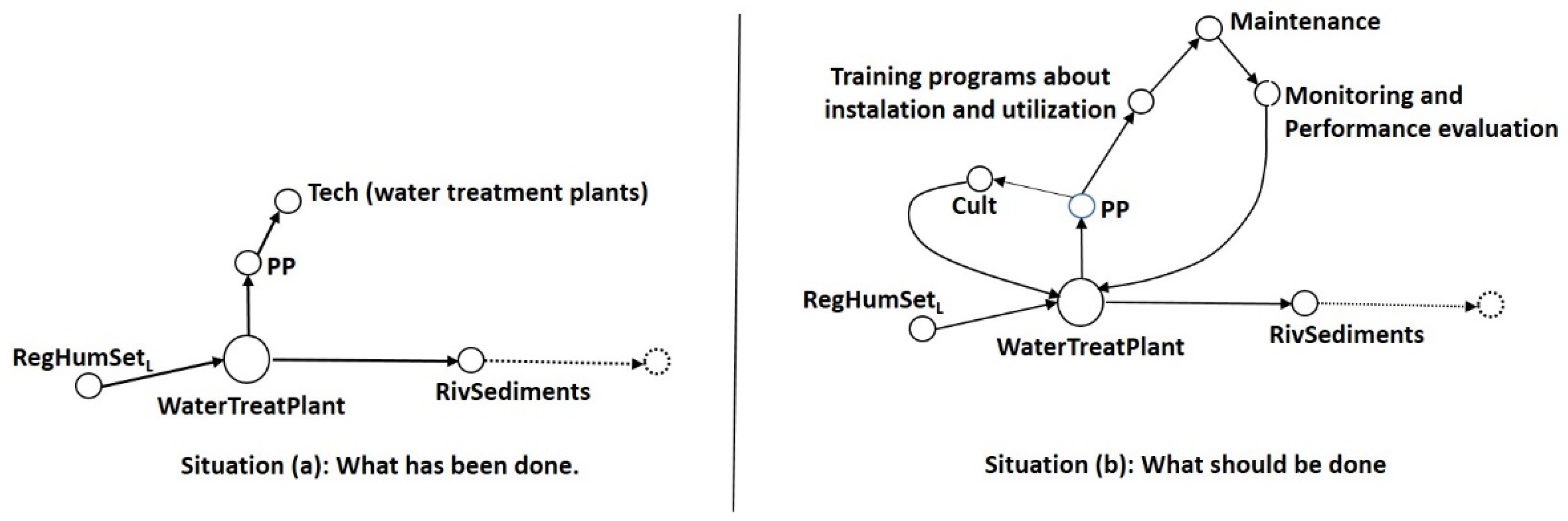
3.3. The Case of the WaterTreatPlant (Water Treatment Plants)

A similar analysis has been carried out for the case of the key WaterTreatPlant node. As we can see in the pathway associated with the key WaterTreatPlant node (see Figure 4), the waste produced by the regular human settlements along the river require the implementation of public policy, the use of adequate technology for the correct functioning of a water treatment plant, and obviously environmental culture programs. The nexus of these three activities aims at reducing the generation of waste. Figure 7 shows two situations, where situation (a) represents the implementation of most of the water treatment plants installed in the municipality of Acapulco. Meanwhile, situation (b) shows the sequence of the main actions to be implemented to avoid temporal disorders for the sake of a good water treatment plant performance.
Situation (a) shows the order of actions carried out to deal with the problem of waste water. As we note in situation (a), regular human settlements require the installation of water treatment plants (WaterTreatPlant node), which will exert effects on the river sediments, in such a way that if a water treatment plant works properly, then the damage caused by river sediments will be reduced. Otherwise, the river sediments will be more and more harmful as the performance of the water treatment plant decreases.
Since the 1990s, 16 water treatment plants have been installed in the municipality of Acapulco, but currently only two of them work. Despite not working to optimal capacity, they work. We mentioned before that the Tres Palos lagoon belongs to the Acapulco municipality. The main concern is that several of those that do not work dump the wastewater directly into the lagoon or into the Rio de la Sabana, which is the river that feeds the lagoon with water. In addition, there is no project for a wastewater treatment plant specifically applied to the Tres Palos coastal lagoon. Once again, the lack of plans aimed at guiding the implementation of these water treatment plants has been a recurrent issue. Firstly, the environmental culture programs were overlooked or ignored or neglected. Secondly, the implementation of water treatment plants required a sequence of essential actions, which was not taken into account. These essential actions are (See Figure 7, situation (b)): (1) Training programs to acquire an adequate technical knowledge related to the installation and utilization of water treatment plants; (2) Maintenance programs of the water treatment plant; (3) Monitoring and evaluation of the performance of these plants. In conclusion, we can confirm that temporal disorder has occurred in most of the water treatment plants, because they operate without formal technology training programs, without sufficient maintenance, without monitoring, and evaluation performance was totally absent. In addition, a lack of budget for the operation and the maintenance tasks of the equipment has been a recurrent concern for all of the water treatment plants already installed. Situation (b) shows a sequence of actions aimed at correcting the temporal disorders.
We must emphasize that the wastewater treatment plants are installed in locations around the Rio de la Sabana and the Tres Palos Coastal Lagoon, almost all of them not working, which suggests that the wastewater may be dumped into waterbodies such as the Rio de la Sabana. We point out that in spite of the existence of public policies, the municipality does not take them into consideration.
As a final reflection about the two key nodes (ConsMangRes and WaterTreatPlant) analyzed and discussed above, we show in Figure 8 a sequence of images that describes the mangrove distribution around the lagoon during the period 1981–2020, which is large enough to confirm the degradation of the mangrove during the last 39 years. The National Commission for the Knowledge and Use of Biodiversity (CONABIO, for its acronyms in Spanish) provides users with information related to the mangrove cover area, which is classified in four periods: 1981–2005, 2005–2010, 2010–2015, and 2015–2020. In the first period (1981–2005), the mangrove cover area was 1,046,646 ha, whereas for the last period (2015–2020) it was 653.99 ha. We observe (Figure 9) a degradation of the mangrove in the southwest of the lagoon during the periods (1981–2005) and (2005–2010). Meanwhile, due to the effects of reforestation activity, we observe certain recovery of the mangrove cover during the periods 2010–2015 and 2015–2020. However, if we take into account the total period 1981–2020, we ratify that, although the legal regulations mentioned before in relation to mangroves are clear enough, the mangrove cover area has decreased.
Figure 9 shows an important increase in the mangrove cover area, from 621.778 to 653.99 ha, during the last period of time. This increase can be associated with a reforestation project carried out by CONABIO from 2008 to 2013. The graphics shown in Figure 9 shows the loss of mangrove cover in hectares and their corresponding percentages. Based on the preceding arguments, we suggest that this degradation could have been brought about by inadequate disposal of wastewater, solid and special handling waste, along with the irregular agricultural practices, which can be interpreted as a lack of environmental culture in the local population and important negligence by the municipality.

3.4. Final Global Analysis and Discussion

The results derived from analyses of pathways showed that the agriculture practices around the Tres Palos Coastal Lagoon and along the Sabana River exert important effects on the mangrove loss and significantly influence the pollution of the river and lagoon. Such pollution requires the support of policies, environmental culture, and technological skills, mainly represented by wastewater treatment (WWT) plants to improve the water quality.
Agricultural practices and deforestation by local populations and timber companies in mangroves have caused important damage, thus contributing to unsustainable developments [46]. Important information related to mangrove loss indicates that during the agricultural era (1800–1940), the area of mangroves declined 45% in Puerto Rico [47]. A similar situation occurred in India, reporting 40% of mangrove loss during the last century, where agriculture practices represented one of the most important causes [48]. On the one hand, loss of mangroves continues to increase more rapidly in developing countries, where 90% of the world’s mangroves are located. On the other hand, it is important to note that human communities would lose their livelihood, including activities relating to food, timber, chemical and medicines, to become a world without mangroves [49].
Agricultural practices contribute to the pollution of water in the fluvial-lagoon system formed by the Sabana River and the Tres Palos Lagoon. Agricultural practices usually increase as population increases, due to the installation of new settlements around the lagoon and along the river. The economy of the Acapulco municipality depends on tourist activities, mostly represented by national tourism, particularly with people coming from Mexico City every weekend of the year, during the summer and for end of year festivities. Thus, a major concern for this city is to establish how the level of pollution of local water resources could hinder the achievement of sustainable conditions relating to tourism activities. As mentioned before, the Tres Palos Coastal Lagoon is located in the Acapulco Municipality. For instance, the Sabana River-Tres Palos Lagoon area suffered an important population increase from 1970 to 2000. The population in 1970 was 186,595 and in 2000 it had increased to 648,431 inhabitants. That is, the population increased by 3.5 over 30 years, in the 17 settlements of the area. In 9 of these 17 settlements, agricultural practices take place, where residual materials, agrochemicals, and organic waste have significantly damaged water resources. Despite these damages the support based on the implementation of WWT plants have been insufficient, non-existent or operating under inefficient conditions along the course of the Sabana River [50].
One of the reasons for the unsuccessful implementation of WWT plants is the lack of criteria aimed at supporting the decision-making process for selecting the correct WWT plants. Usually, a set of indicators composed of environmental, societal, and economic aspects are used to determine the sustainability of WWT technologies [51,52,53].
Economic indicators determine the cost of the technology and how affordable this is for the community; environmental technology is related to the capacity of the WWT plant to remove wastewater components, such as nitrogen, phosphorous, and pathogens, among others; and societal indicators capture the cultural acceptance of the technology. An analytical hierarchical process (AHP) method has been integrated into composite indicators that take into account environmental, economic, and social aspects. The AHP aims to assign weight to each indicator, thus allowing the incorporation of experts to support the decision-making process [53]. In developing countries, the aspects related to the affordability and reliability is very important for the implementation of WWT systems. Centralized WWT systems along with the cost of operation result unaffordable for developing countries. Instead, a decentralized approach has been proposed [54].
As mentioned before, addressing the problems derived from the 7 key nodes requires a planning system integrated into an environmental management system that supports the decision-making process for the selection of adequate management actions and the correct coordination between them to improve their performance. The problems associated with the 7 identified key nodes related to the disturbances of the eutrophication process become relevant in the process of achieving the sustainability of the ecosystem under study. These problems are associated with several of the 17 SDGs (Sustainable Development Goals) set up in 2015 by the United Nations General Assembly [55,56]. We consider that the 7 key nodes are related to the following SDGs: clean water and sanitation; responsible consumption and production; climate action; life below water; life on land in the part of sustainably managed forest (the mangrove forest) and halt biodiversity loss. Integrated and collaborative approaches for the implementation of SDGs has been suggested by the UN. However, the implementation of actions to achieve sustainable conditions at national level becomes a hard problem to solve. In addition, the selection of public policies by decision-makers should be submitted to specificities of each ecosystem, thus regional and local management should take into account specific needs in the context of a particular coastal lagoon [57]. Therefore, due to the fact that most of the actions to be implemented take place locally, the municipalities seem to be the obvious candidates to coordinate the efforts to achieve SDGs [58,59]. Nevertheless, due to cultural differences between diverse professions within the context of municipalities, the cooperation between different actors becomes frequently unfeasible. Thus, the adoption of an environmental management system in the entire municipality has been proposed, as a feasible solution [60].
Due to the complexity of ecosystems, such as coastal lagoons, an important number of problems emerge, mainly in developing countries, and mainly caused by anthropogenic activities. Thus, management actions should be implemented for the sake of the preservation and restoration of coastal lagoon environment. The set of management actions to be implemented requires the development of management plans integrated in environmental management systems to ensure a correct spatiotemporal coordination aimed at achieving sustainable conditions [61].

4. Conclusions

We have dealt with the problem of understanding the dynamics of the cultural eutrophication process of coastal lagoons, which are considered complex systems. We have seen that the cultural eutrophication process is strongly characterized by multifactorial interactions between anthropogenic activities that contribute to the disturbances associated with the eutrophication process.
The developed pathways that link indirect drivers with direct drivers facilitated the understanding of the dynamic taking place in the eutrophication process of coastal lagoons. Pathways have also been used to identify key nodes, which are characterized by their potential to bring about temporal disorders that may increase the disturbances of the eutrophication process. The key nodes identified in the pathways are related to agricultural practices around the lagoon and along the river, solid urban waste generation at the level of the lagoon and river, consumption of mangrove resources leading to mangrove loss, generation of special handling waste at the level of the river, and wastewater treatment.
The problems associated with key nodes require the implementation of anthropogenic activities related to public policies, technological, and environmental cultural factors, which should be combined and synchronized to avoid temporal disorders that may contribute to the eutrophication process disturbances. This affects the trophic state of the lagoon and the spatial landscape reflected in the area of mangrove loss.
We have applied the developed methods to the Tres Palos Coastal Lagoon, situated in the municipality of Acapulco, Guerrero, Mexico, on the Pacific Coast. We have analyzed two key nodes, the first one related to the consumption of mangrove resources and the second one related to wastewater treatment plants. We have analyzed the relationship of these two key nodes with the agricultural practices node. For both, we have analyzed plans that may lead to temporal disorders due to the lack of temporal coordination between the anthropogenic activities (public policies, technological skills, and environmental culture programs) aimed at reducing the disturbances associated with the cultural eutrophication process.
It has been suggested that technological activities, such as reforestation and the installation of WWT systems, should be implemented simultaneously with environmental cultural programs. We have argued that learners should take environmental courses in the real sites, where the mangroves and WWT plants are located. In this way, they will adopt the projects related to these specific environmental issues. For example, the fact of knowing, following, and participating in the process of reforestation produces an effect that wakes up the sense of ownership of the project.
Seven key nodes (three belonging to the lagoon pathways and four pathways belonging to the river), each one requiring activities related to the nexus to reduce disturbances in the eutrophication process. Implementing the activities simultaneously to address the problems related to the 7 key nodes would reduce the disturbances associated with the eutrophication process. However, addressing 7 nodes at risk represents a huge challenge, because the planning task to build adequate temporal coordination and synchronization would be a very complex problem to solve. In addition, it would be too expensive to be really feasible.
The implementation of activities or actions to address these seven issues should be carried out at the correct scale to make them feasible. It is suggested that they be carried out at municipal level since most of the actions that need to be implemented take place locally. Moreover, to address the problem related to the lack of cooperation due to cultural differences between diverse professions working for the municipality, we suggest adopting an environmental management system, within which plans of actions would be developed to ensure adequate coordination between the actions to be implemented.

Author Contributions

Conceptualization, F.R.-Q., A.I.C.-J. and E.T.-S.; methodology, F.R.-Q.; validation, E.T.-S.; formal analysis, F.R.-Q., A.I.C.-J., E.T.-S., A.L.J.-L., A.L.R.-H., M.R.-U. and J.L.R.-A.; investigation, F.R.-Q. and A.I.C.-J.; writing—original draft preparation, F.R.-Q., A.I.C.-J. and E.T.-S.; writing—review and editing, F.R.-Q. and A.I.C.-J.; supervision, F.R.-Q. All authors have read and agreed to the published version of the manuscript.

Funding

This research received no external funding.

Institutional Review Board Statement

Not applicable.

Informed Consent Statement

Not applicable.

Data Availability Statement

Not applicable.

Acknowledgments

We thank Rosalind Pearson for her comments and suggestions that improved our manuscript. We also thank reviewers for their valuable comments and suggestions to improve the manuscript.

Conflicts of Interest

The authors declare no conflict of interest.

References

  1. Bascompte, J.; Ricard, V.S. Rethinking complexity: Modelling spatiotemporal dynamics in ecology. Trends Ecol. Evol. 1995, 10, 361–366. [Google Scholar] [CrossRef]
  2. White, E.P.; Morgan Ernest, S.J.; Adler, P.B.; Hurlbert, A.H.; Lyons, S.K. Integrating spatial and temporal approaches to understanding species richness. Philos. Trans. R. Soc. B Biol. Sci. 2010, 365, 3633–3643. [Google Scholar] [CrossRef] [Green Version]
  3. Pérez-Ruzafa, A.; Marcos, C.; Pérez-Ruzafa, I.M.; Barcala, E.; Hegazi, M.I.; Quispe, J. Detecting changes resulting from human pressure in a naturally quick-changing and heterogeneous environment: Spatial and temporal scales of variability in coastal lagoons. Estuar. Coast. Shelf Sci. 2007, 75, 175–188. [Google Scholar] [CrossRef]
  4. Belovsky, G.E.; Botkin, D.B.; Crowl, T.A.; Cummins, K.W.; Franklin, J.F.; Hunter, M.L.; Joern, M.; Joern, A.; Lindenmayer, D.B.; MacMahon, J.A.; et al. Ten suggestions to strengthen the science of ecology. BioScience 2004, 54, 345–351. [Google Scholar] [CrossRef] [Green Version]
  5. Hewitt, J.E.; Thrush, S.F.; Dayton, P.K.; Bonsdorff, E. The effect of spatial and temporal heterogeneity on the design and analysis of empirical studies of scale-dependent systems. Am. Nat. 2007, 169, 398–408. [Google Scholar] [CrossRef]
  6. Pérez-Ruzafa, A.; Marcos, C.; Pérez-Ruzafa, I.M. Mediterranean coastal lagoons in an ecosystem and aquatic resources management context. Phys. Chem. Earth Parts A/B/C 2011, 36, 160–166. [Google Scholar] [CrossRef]
  7. Xiang, Y.; Meng, J.; You, N.; Chen, P.; Yang, H. Spatio-temporal Analysis of Anthropogenic Disturbances on Landscape pattern of tourist Destinations: A case study in the Li River Basin, China. Sci. Rep. 2019, 9, 19285. [Google Scholar] [CrossRef]
  8. Xiao, L.; Zhang, Q.; Niu, C.; Wang, H. Spatiotemporal Patterns in RiverWater Quality and Pollution Source Apportionment in the Arid Beichuan River Basin of Northwestern China Using Positive Matrix Factorization Receptor Modeling Techniques. Int. J. Environ. Res. Public Health 2020, 17, 5015. [Google Scholar] [CrossRef] [PubMed]
  9. Moncelon, R.; Gouazé, M.; Pineau, P.; Beneteau, E.; Bréret, M.; Philippine, O.; Robin, F.X.; Dupuy, C.; Metzger, E. Coupling between sediment biogeochemistry and phytoplankton development in a temperate freshwater marsh (Charente-Maritime, France): Evidence of temporal pattern. Water Res. 2021, 189, 116567. [Google Scholar] [CrossRef]
  10. Karami, J.; Alimohammadi, A.; Modabberi, S. Analysis of the Spatio-Temporal Patterns of Water Pollution and Source Contribution Using the MODIS Sensor Products and Multivariate Statistical Techniques. IEEE J. Sel. Top. Appl. Earth Obs. Remote Sens. 2012, 5, 1243–1255. [Google Scholar] [CrossRef]
  11. Duc Nguyen, H.; Hong Quan, N.; Xuan Quang, N.; Duy Hieu, N.; Viet Thang, L. Spatio-temporal pattern of water quality in the aigon-Dong Nai river system due to waste water pollution sources. Int. J. River Basin Manag. 2019, 17, 1–34. [Google Scholar] [CrossRef]
  12. VanLandeghem, M.M.; Meyer, M.D.; Cox, S.B.; Sharma, B.; Patiño, R. Spatial and temporal patterns of surface water quality and ichthyotoxicity in urban and rural river basins in Texas. Water Res. 2012, 46, 6638–6651. [Google Scholar] [CrossRef]
  13. Hennemann, M.C.; Petrucio, M.M. Spatial and temporal dynamic of trophic relevant paramertes in a subtropical coastal lagoon in Brazil. Environ. Monit. Assess 2011, 181, 347–361. [Google Scholar] [CrossRef]
  14. Chen, Y.; Zhao, K.; Wu, Y.; Gao, S.; Cao, W.; Bo, Y.; Shang, Z.; Wu, J.; Zhou, F. Spatio-Temporal Patterns and Source Identification of Water Pollution in Lake Taihu (China). Water 2016, 8, 86. [Google Scholar] [CrossRef] [Green Version]
  15. Sheng, J.; Tang, W. Spatiotemporal variation patterns of water pollution drivers: The case of China’s South-North Water Transfer Project. Sci. Total Environ. 2020, 761, 143190. [Google Scholar] [CrossRef] [PubMed]
  16. Rasi Nezami, S.; Nazariha, M.; Moridi, A.; Baghvand, A. Environmentally sound water resources management in catchment level using DPSIR model and scenario analysis. Int. J. Environ. Res. 2013, 7, 569–580. [Google Scholar] [CrossRef]
  17. Shao, C.; Guan, Y.; Chu, C.; Shi, R.; Ju, M.; Shi, J. Trends analysis of ecological environment security based on DPSIR model in the coastal zone: A survey study in Tianjin, China. Int. J. Environ. Res. 2014, 8, 765–778. [Google Scholar] [CrossRef]
  18. Gari, S.R.; Newton, A.; Icely, J.D. A review of the application and evolution of the DPSIR framework with an emphasis on coastal social-ecological systems. Ocean Coast. Manag. 2005, 103, 63–77. [Google Scholar] [CrossRef] [Green Version]
  19. Lynch, A.J.J. The usefulness of a threat and disturbance categorization developed for Queensland wetlands to environmental management, monitoring and evaluation. Environ. Manag. 2011, 47, 40–55. [Google Scholar] [CrossRef]
  20. Mysiak, J.; Giupponi, C.; Rosato, P. Towards the development of a decision support system for water resource management. Environ. Model. Softw. 2005, 20, 203–214. [Google Scholar] [CrossRef]
  21. Balzan, M.V.; Pinheiro, A.M.; Mascarenhas, A.; Morán-Ordóñez, A.; Ruiz-Frau, A.; Carvalho-Santos, C.; Vogiatzakis, I.N.; Arends, J.; Santana-Garcon, J.; Roces-Díaz, J.V.; et al. Improving ecosystem assessments in Mediterranean social-ecological systems: A DPSIR analysis. Ecosyst. People 2019, 15, 136–155. [Google Scholar] [CrossRef] [Green Version]
  22. Balkanlou, K.R.; Müller, B.; Cord, A.F.; Panahi, F.; Malekian, A.; Jafari, M.; Egli, L. Spatiotemporal dynamics of ecosystem services provision in a degraded ecosystem: A systematic assessment in the Lake Urmia basin, Iran. Sci. Total Environ. 2020, 716, 137100. [Google Scholar] [CrossRef] [PubMed]
  23. Jia, Y.; Shen, J.; Wang, H.; Dong, G.; Sun, F. Evaluation of the spatiotemporal variation of sustainable utilization of water resources: Case Study from Henan Province (China). Water 2018, 10, 554. [Google Scholar] [CrossRef] [Green Version]
  24. Mateus, M.; Campuzano, F.J. The DPSIR framework applied to the integrated management of coastal areas. In Perspectives on Integrated Coastal Management in South America; Neves, R., Baretta, J.W., Mateus, M., Eds.; IST Press: Lisbon, Portugal, 2008. [Google Scholar] [CrossRef]
  25. Carpenter, S.R.; Mooney, H.A.; Perrings, C.; Reid, W.V.; Sarukan, J.; Scholes, R.J.; Whyte, A.; Agard, J.; Capístrano, D.; DeFries, R.S.; et al. Science for managing ecosystem services: Beyond the Millennium Ecosystem Assessment. Proc. Natl. Acad. Sci. USA 2009, 106, 1305–1312. [Google Scholar] [CrossRef] [Green Version]
  26. IPBES. Summary For Policymakers of the Global Assessment Report on Biodiversity and Ecosystem Services of the Intergovernmental Science-Policy Platform on Biodiversity and Ecosystem Services; Díaz, S., Settele, J., Brondízio, E.S., Ngo, H.T., Guèze, M., Agard, J., Arneth, A., Balvanera, P., Brauman, K.A., Butchart, S.H.M., et al., Eds.; IPBES Secretariat: Bonn, Germany, 2019; 56p. [Google Scholar]
  27. Newton, A.; Icely, J.; Falcao, M.; Nobre, A.M.; Nunes, J.P.; Ferreira, J.; Vale, C. Evaluation of eutrophication in the Ria Formosa coastal lagoon, Portugal. Cont. Shelf Res. 2003, 23, 1945–1961. [Google Scholar] [CrossRef]
  28. Esteves, F.A.; Caliman, A.; Santangelo, J.M.; Guarient, R.D.; Farjalla, V.F.; Brozelli, R.L. Neotripical coastal lagoons: An appraisal of their biodiversity, functioning, threats and conservation management. Braz. J. Biol. 2008, 68, 967–981. [Google Scholar] [CrossRef] [PubMed] [Green Version]
  29. Otu, M.K.; Ramlal, P.; Wilkinson, P.; Hall, R.I.; Hecky, R.E. Paleolimnological evidence of the effects of recent cultural eutrophication during the last 200 years in Lake Malawi, East Africa. J. Great Lakes Res. 2011, 37, 61–74. [Google Scholar] [CrossRef]
  30. Thevenon, F.; Adatte, T.; Wildi, W.; Poté, J. Antibiotic resistant bacteria/genes dissemination in lacustrine sediments highly increased following cultural eutrophication of Lake Geneva (Switzerland). Chemosphere 2012, 86, 468–476. [Google Scholar] [CrossRef] [PubMed] [Green Version]
  31. Chislock, M.F.; Doster, E.; Zitomer, R.A.; Wilson, A.E. Eutrophication: Causes, Consequences, and Controls in Aquatic Eco-systems. Nat. Educ. Knowl. 2013, 4, 10. [Google Scholar]
  32. Cotovicz, L.C., Jr.; Knoppers, B.A.; Brandini, N.; Costa Santos, S.J.; Abril, G. A strong CO2 sink enhanced by eutrophication in a tropical coastal embayment (Guanabara Bay, Rio de Janeiro, Brazil). Biogeosciences 2015, 12, 6125–6146. [Google Scholar] [CrossRef] [Green Version]
  33. Van Rijssel, J.C.; Hecky, R.E.; Kishe-Machumu, M.A.; Witte, F. Changing ecology of Lake Victoria cichlids and their environment: Evidence from C13 and N15 analyses. Hydrobiologia 2016, 791, 175–191. [Google Scholar] [CrossRef] [Green Version]
  34. Haas, M.; Baumann, F.; Castella, D.; Haghipour, N.; Reusch, A.; Strasser, M.; Eglinton, T.I.; Dubois, N. Roman-driven cultural eutrophication of Lake Murten, Switzerland. Earth Planet. Sci. Lett. 2019, 505, 110–117. [Google Scholar] [CrossRef]
  35. Fielding, J.J.; Croudace, I.W.; Kemp, A.E.; Pearce, R.B.; Cotterill, C.J.; Langdon, P.; Avery, R. Tracing lake pollution, eutrophication and partial recovery from the sediments of Windermere, UK, using geochemistry and sediment microfabrics. Sci. Total Environ. 2020, 722, 137745. [Google Scholar] [CrossRef] [PubMed]
  36. EEA. Eutrophication in Europe’s coastalwaters. In Topic Report No. 7; European Environmental Agency: Copenhagen, Denmark, 2001. [Google Scholar]
  37. UNEP. Eutrophication Monitoring and Strategy of MED POL; UNEP(DEC)/MEDWG: Athens, Greece, 2003. [Google Scholar]
  38. Dillon, P.; Kirchner, W. The effects of geology and land use on the export of phosphorus from watersheds. Water Res. 1975, 9, 135–148. [Google Scholar] [CrossRef]
  39. Carpenter, S.R. Eutrophication of aquatic ecosystems: Bistability and soil phosphorus. Proc. Natl. Acad. Sci. USA 2005, 102, 10002–10005. [Google Scholar] [CrossRef] [Green Version]
  40. Granat, L. Deposition of Nitrate and Ammonium from the Atmosphere to the Baltic Sea. Ecol. Stud. 2001, 148, 133–148. [Google Scholar] [CrossRef]
  41. Pérez-Ruzafa, Á.; Marcos, C.; Pérez-Ruzafa, M. Recent advances in coastal lagoons ecology: Evolving old ideas and assump-tions. Transit. Waters Bull. 2011, 5, 50–74. [Google Scholar] [CrossRef]
  42. Lo, W.T.; Purcell, J.E.; Hung, J.J.; Su, H.M.; Hsu, P.K. Enhancement of jellyfish (Aurelia aurita) populations by extensive aquaculture rafts in a coastal lagoon in Taiwan. ICES J. Mar. Sci. 2008, 65, 453–461. [Google Scholar] [CrossRef] [Green Version]
  43. La Notte, A.; Turvani, M.; Giaccaria, S. conomic valuation of ecosystem services at local level for policy makers and planners. The case of the island of St. Erasmo in the Lagoon of Venice. Environ. Econ. 2001, 2, 87–103. [Google Scholar]
  44. Rova, S.; Pranovi, F.; Müller, F. Provision of ecosystem services in the lagoon of Venice (Italy): An initial spatial assessment. Ecohydrol. Hydrobiol. 2015, 15, 13–25. [Google Scholar] [CrossRef]
  45. O’Higgins, T.; Nogueira, A.A.; Lillebø, A.I. A simple spatial typology for assessment of complex coastal ecosystem services across multiple scales. Sci. Total Environ. 2019, 649, 1452–1466. [Google Scholar] [CrossRef] [PubMed]
  46. Pons, L.J.; Fiselier, J.L. Sustainable development of mangroves. Landsc. Urban Plan. 1991, 20, 103–109. [Google Scholar] [CrossRef]
  47. Martinuzzi, S.; Gould, W.A.; Lugo, A.E.; Medina, E. Conversion and recovery of Puerto Rican mangroves: 200 years of change. For. Ecol. Manag. 2009, 257, 75–84. [Google Scholar] [CrossRef]
  48. Sahu, S.C.; Suresh, H.S.; Murthy, I.K.; Ravindranath, N.H. Mangrove area assessment in India: Implications of loss of mangroves. J. Earth Sci. Clim. Chang. 2015, 6, 1000280. [Google Scholar] [CrossRef] [Green Version]
  49. Duke, N.C.; Meynecke, J.O.; Dittmann, S.; Ellison, A.M.; Anger, K.; Berger, U.; Cannicci, S.; Diele, K.; Ewel, K.C.; Field, C.D.; et al. A World without Mangroves? Science 2007, 317, 41–42. [Google Scholar] [CrossRef] [PubMed] [Green Version]
  50. Sánchez-Crispin, A. Water Resources, Tourism and Sustainable Development in the Tres Palos Lagoon Area, México. Chapter 8 in Sustainable Futures: Teaching and Learning: A Case Study Approach. [Internet] Margaret Robertson ed. Aust Council for Ed Research. 2007. Available online: https://books.google.com.mx/books?hl=en&lr=&id=8u5wIC7OCUsC&oi=fnd&pg=PA126&dq=treatment+plants+sewage,+mexico,+acapulco&ots=WLfXafBS0&sig=41F6IVrJGYDsfyWwCr29yIPHAZE&redir_esc=y#v=onepage&q=treatment%20plants%20sewage%2C%20mexico%2C%20acapulco&f=false (accessed on 20 July 2021).
  51. Muga, H.E.; James, R.M. Sustainability of wastewater treatment technologies. J. Environ. Manag. 2008, 88, 437–447. [Google Scholar] [CrossRef] [PubMed]
  52. Balkema, A.J.; Heinz, A.P.; Otterpohl, R.; Lambert, F.J.D. Indicators for the sustainability assessment of wastewater treatment systems. Urban Water 2002, 4, 153–161. [Google Scholar] [CrossRef]
  53. Molinos-SEnante, M.; Gómez, T.; Garrido-Baserba, M.; Caballero, R.; Sala-Garrido, R. Assessing the sustainability of small wastewater treatment systems: A composite indicator approach. Sci. Total Environ. 2014, 497–498, 6007–6617. [Google Scholar] [CrossRef]
  54. Massoud, M.A.; Tarhini, A.; Nasr, J.A. Decentralized approaches to wastewater treatmeent and management: Applicability in developing countries. J. Environ. Manag. 2009, 90, 652–659. [Google Scholar] [CrossRef]
  55. The 17 SDGs. [Internet] United Nations. Department of Economic and Social Affairs. Sustainable Development. Available online: https://sdgs.un.org/goals (accessed on 20 July 2021).
  56. Tsalis, T.A.; Malamateniou, K.E.; Koulouriotis, D. New challenges for corporate sustainability reporting: United Nations’ 2030 Agenda for sustainable development goals. Corp. Soc. Responsib. Environ. 2019, 27, 1617–1629. [Google Scholar] [CrossRef]
  57. Dolbeth, M.; Stålnacke, S.P.; Alves, F.L.; Sousa, L.P.; Gooch, G.D.; Khokhlov, V.; Tuchkovenko, Y.; Lloret, J.; Bielecka, M.; Różyński, G.; et al. An integrated Pan-European perspective on coastal Lagoons management through a mosaic-DPSIR approach. Sci. Rep. 2016, 6. [Google Scholar] [CrossRef] [Green Version]
  58. Wilson, E.; Vihlová, D. The Role of Local Government in Environmental Action in Slovakia. Int. J. Justice Sustain. 2010, 5, 255–269. [Google Scholar] [CrossRef]
  59. Gustafsson, S.; Ivner, J. Implementing the Global Sustainable Goals (SDGs) into Municipal Stratergies Applying an Integrated Approach. Handb. Sustain. Sci. Res. 2017, 301–316. [Google Scholar] [CrossRef] [Green Version]
  60. Burström, F. Environmental Management Systems and Co-operation in Municipalities. Int. J. Justice Sustain. 2010, 5, 271–284. [Google Scholar] [CrossRef]
  61. Cataudella, S.; Crosetti, D.; Massa, F. Mediterranean coastal lagoons: Sustainable management and interactions among aquaculture, capture fisheries and the environment. General Fisheries Commission for the Mediterranean. Stud. Rev. 2015, 95. [Google Scholar]
Figure 1. The Tres Palos coastal lagoon located in the Acapulco Municipality of the state of Guerrero, Mexico, on the Pacific Ocean coast.
Water 13 02099 g001
Figure 2. Bottom-up method for building pathways, and the top-down method to guide the analysis and identification of key nodes that may bring about temporal disorders.
Water 13 02099 g002
Figure 3. The pathways related to the lagoon.
Water 13 02099 g003
Figure 4. The pathways related to the river.
Water 13 02099 g004
Figure 5. Plan (a), Plan (b), and Plan (c).
Water 13 02099 g005
Figure 6. The increase of agricultural practices, from 1997 to 2017, along the river and around the lagoon.
Water 13 02099 g006
Figure 7. Situation (a) shows that the implementation of a water treatment plant took place without considering a previous training technical program related to the water treatment plant to be installed. Situation (b) shows the main actions to be implemented before and after the installation of a water treatment plant.
Water 13 02099 g007
Figure 8. Mangrove loss from 1981 to 2020.
Water 13 02099 g008
Figure 9. The decreasing trend of the mangrove cover area from 1981 to 2010 is evident. However, due to a reforestation activity from 2008 to 2013, the mangrove has recovered more than 30 ha of the mangrove area during the last two periods.
Water 13 02099 g009
Publisher’s Note: MDPI stays neutral with regard to jurisdictional claims in published maps and institutional affiliations.

