
Preservation of Modern and MIS 5.5 Erosional Landforms and Biological Structures as Sea Level Markers: A Matter of Luck?

 , ,
, ,  , ,
, ,  , , , , , , , , and add
Show full author list
, , , , , , , , and add
Show full author list
Abstract
:1. Introduction
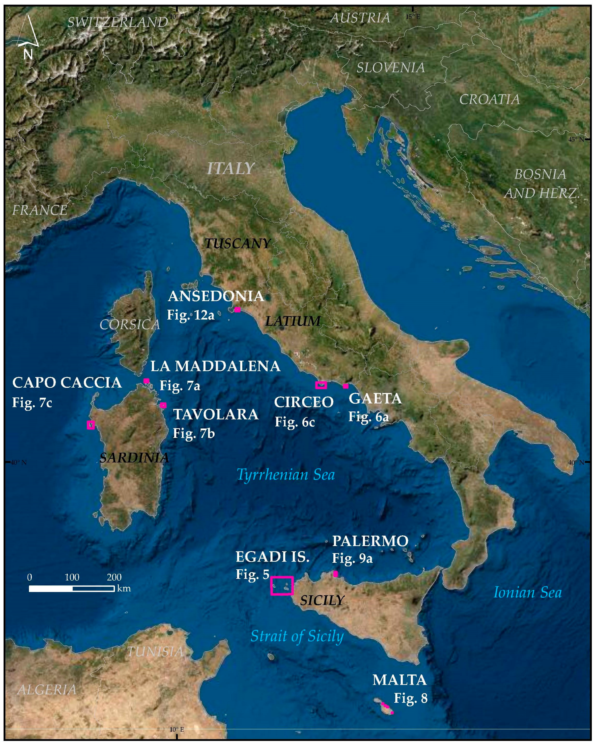
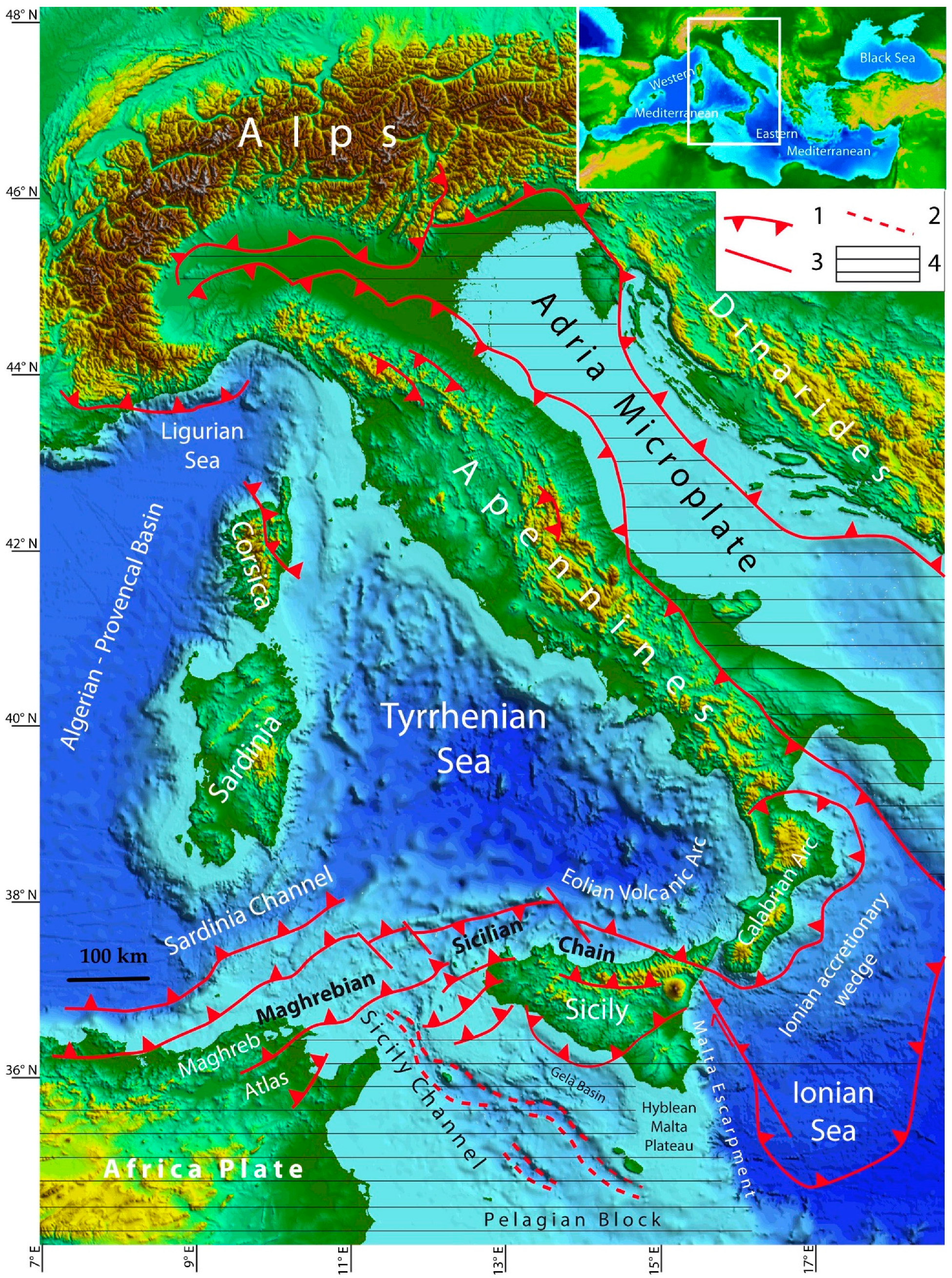
2. Geological and Geomorphological Setting of the Study Area
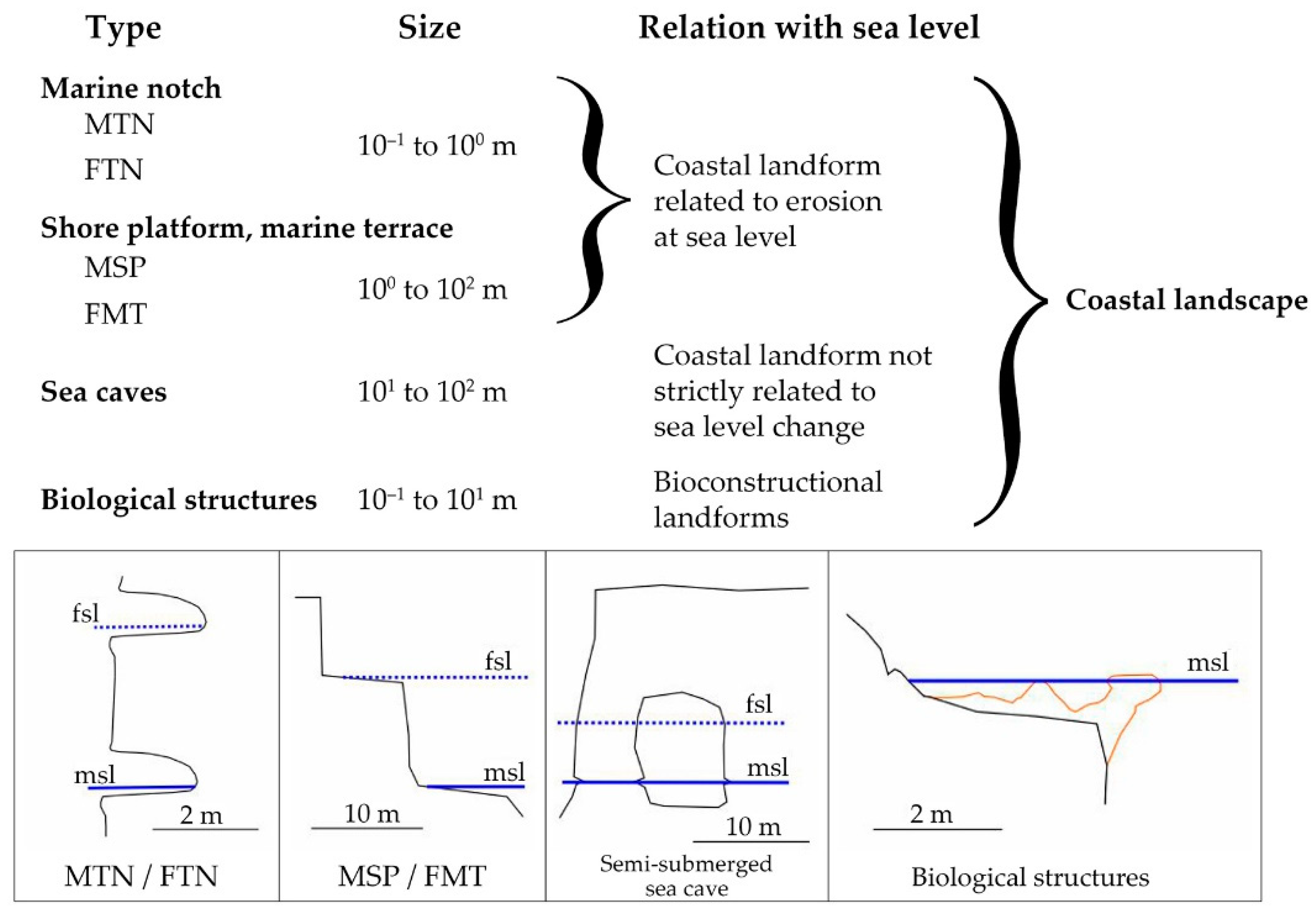
3. Erosional Landforms Related to the Sea Level
3.1. Modern Tidal Notches (MTNs) and Fossil Tidal Notches (FTNs)
3.2. Modern Shore Platforms (MSPs) and Fossil Marine Terraces (FMTs)
3.3. Sea Caves
3.4. Biogenic Structures
4. Material and Methods
4.1. Field Survey Approach
4.2. The Methodological Approach
5. Results
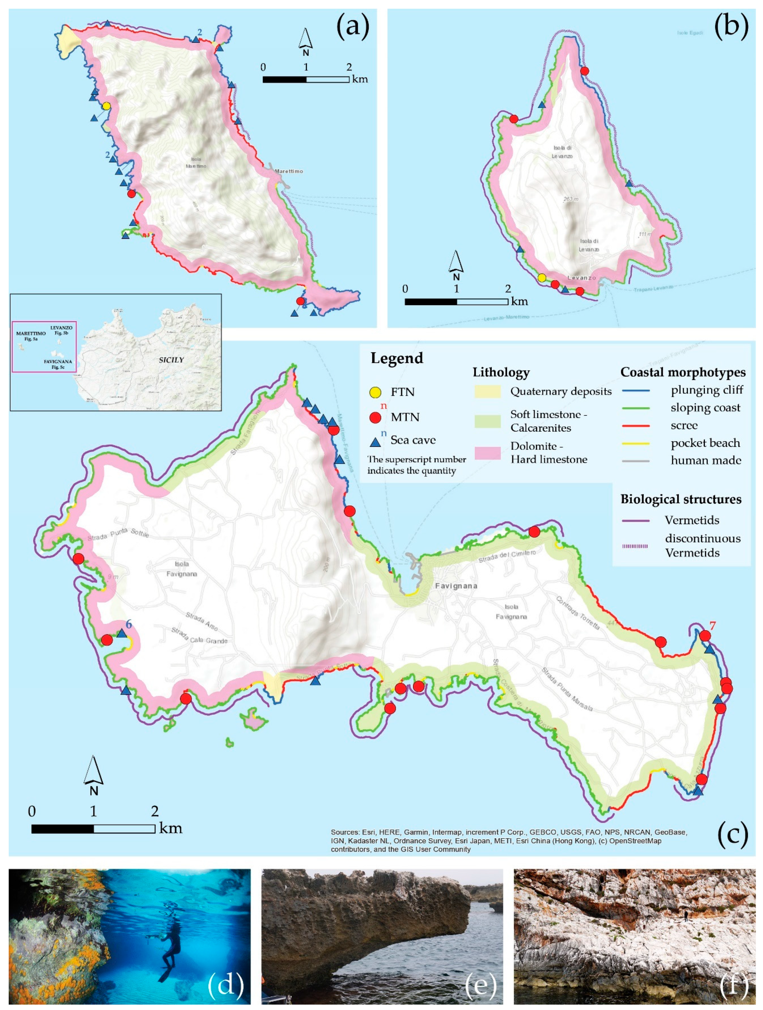
5.1. Egadi Islands
5.1.1. Marettimo Island
5.1.2. Favignana Island
5.1.3. Levanzo Island
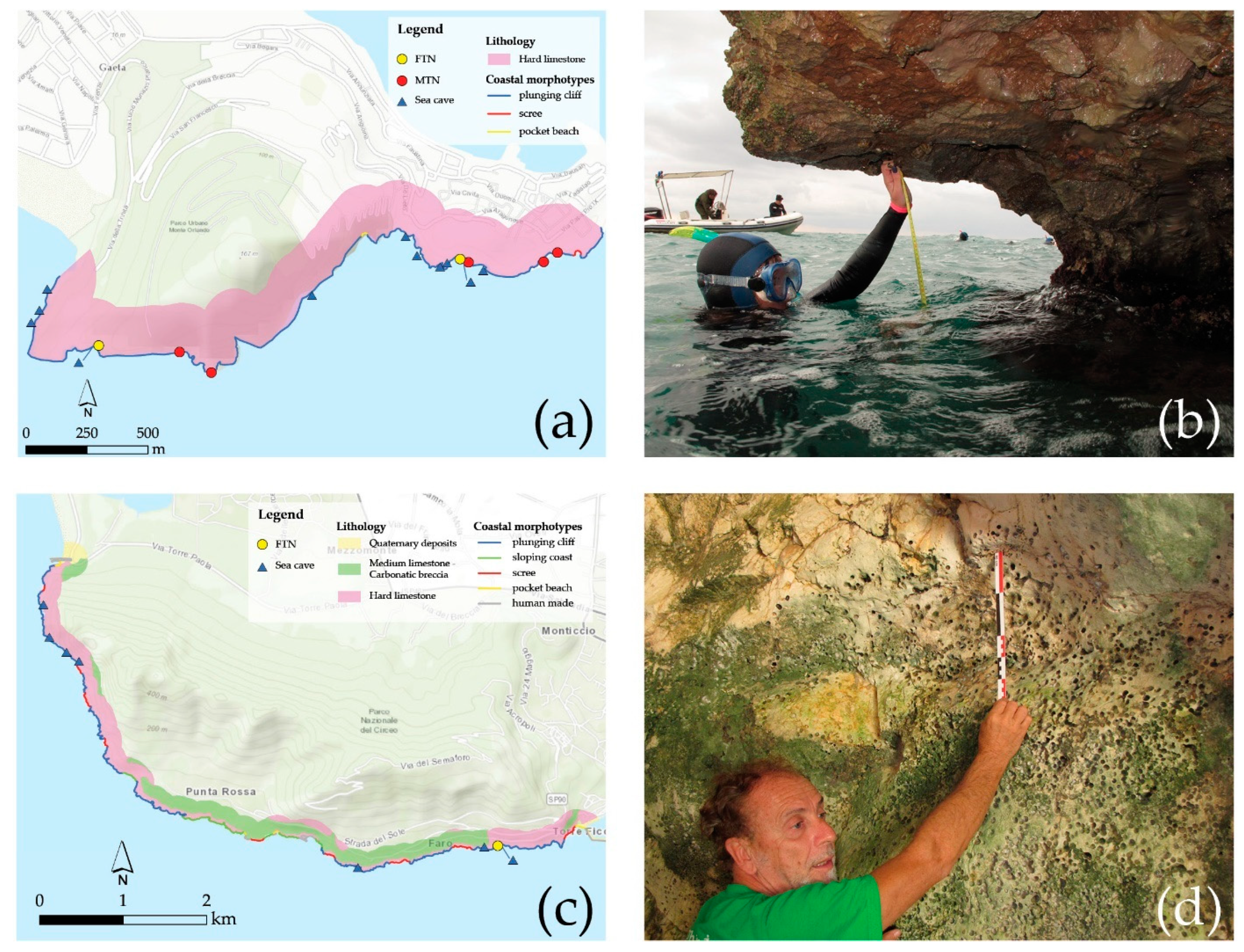
5.2. Gaeta and Circeo Promontory
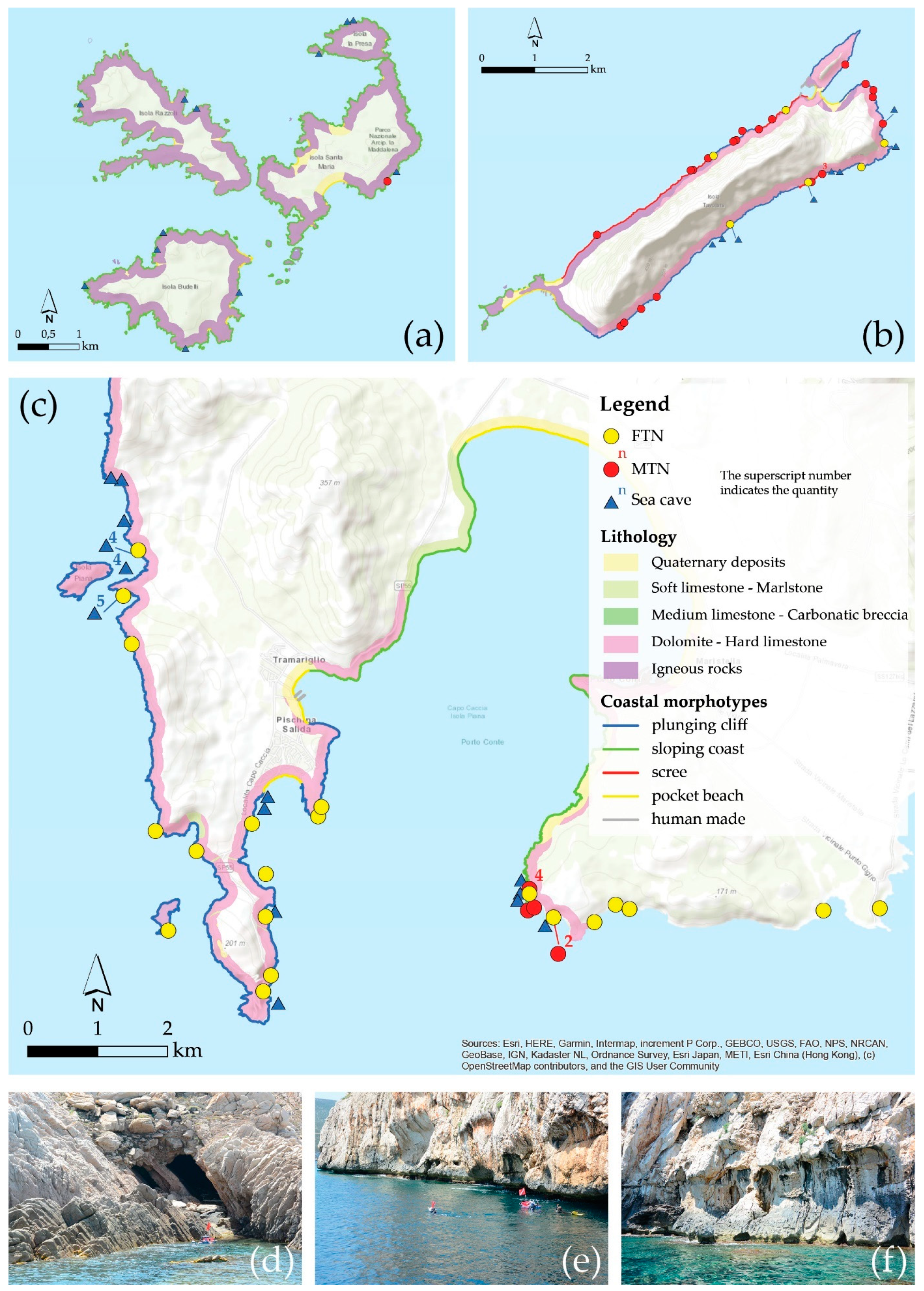
5.3. North Sardinia
5.3.1. Razzoli, Budelli, and Santa Maria Islands (Maddalena Archipelago, Northeastern Sardinia)
5.3.2. Capo Caccia (Northwestern Sardinia)
5.3.3. Tavolara Island (Northeastern Sardinia)
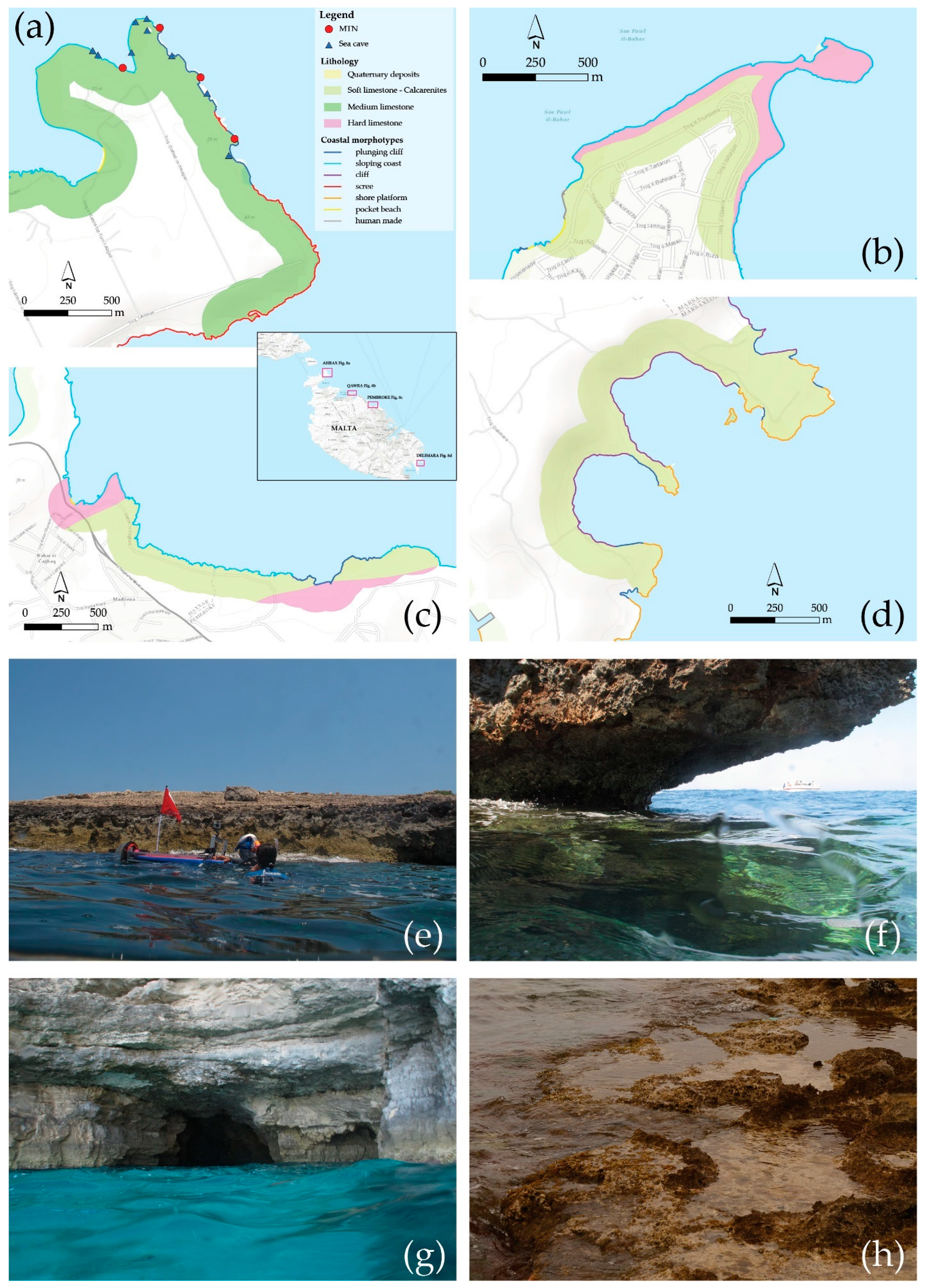
5.4. The Maltese Islands (Eastern Malta)
5.4.1. Aħrax (Mellieħa)
5.4.2. Qawra
5.4.3. Pembroke
5.4.4. Delimara (Xrobb l-Għaġin, Ħofra l-Kbira)
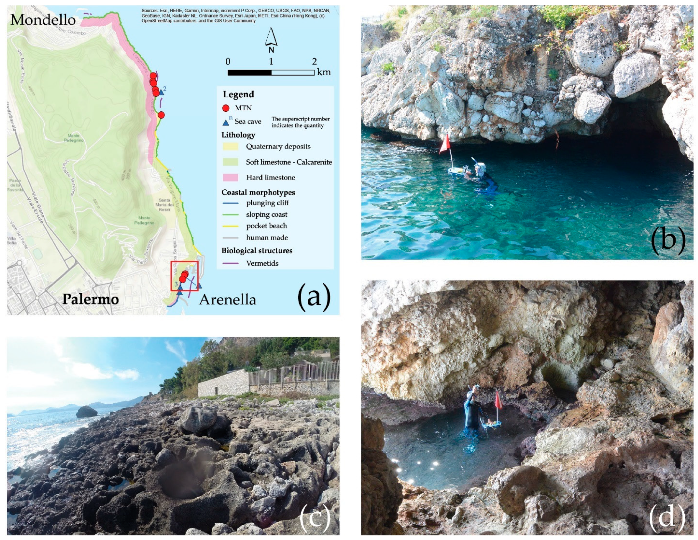
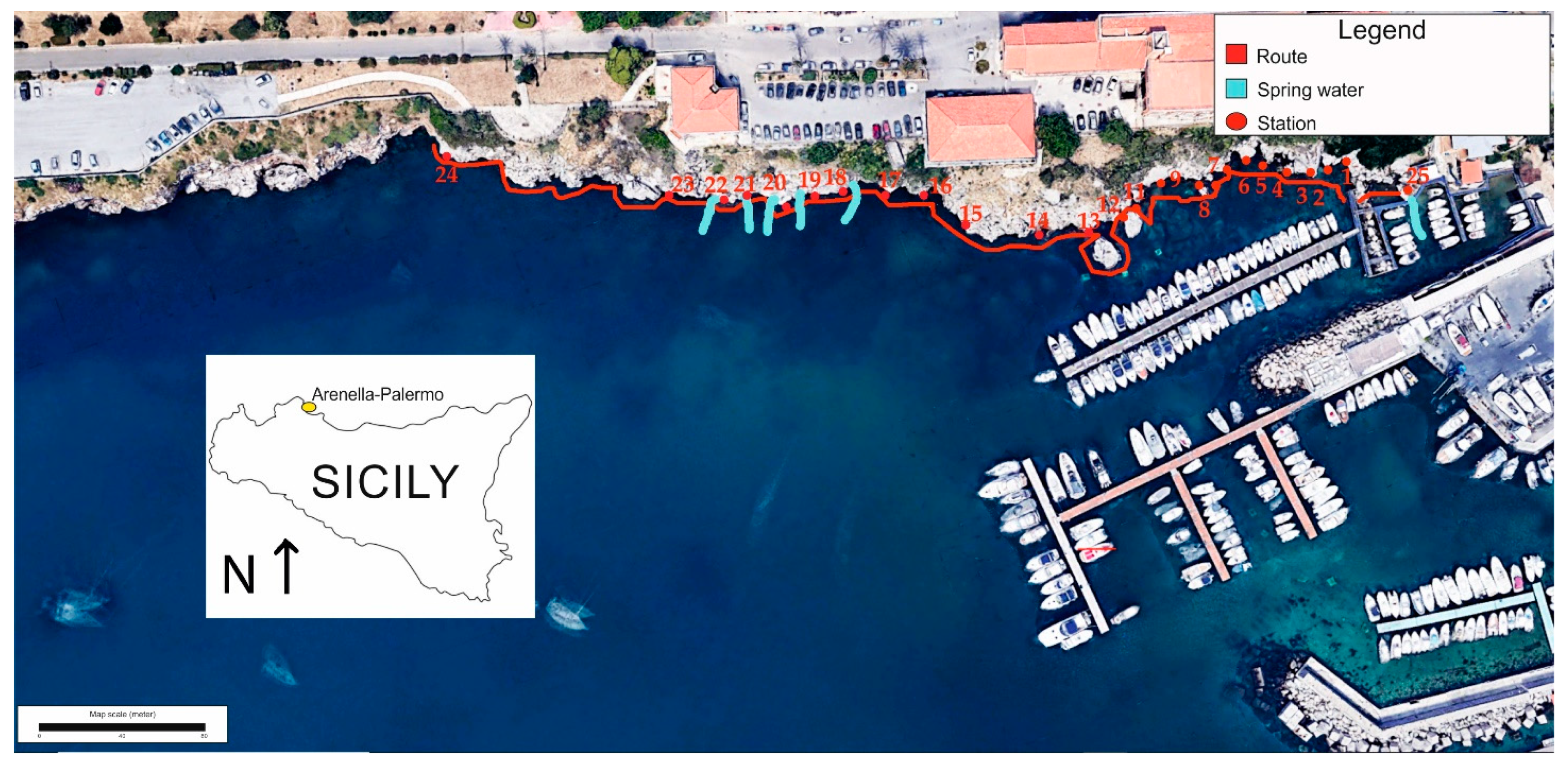
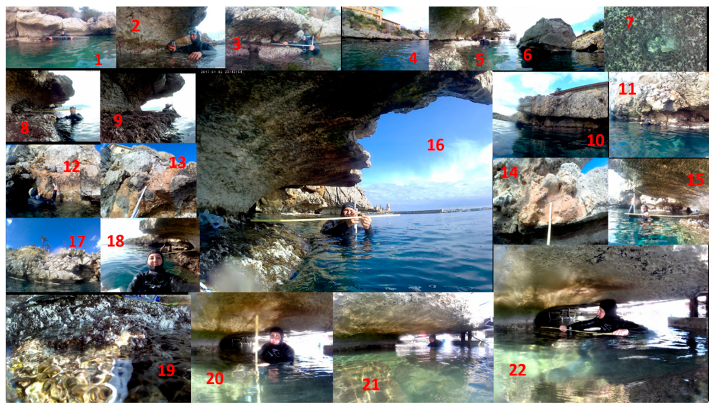
5.5. North Coast of Palermo
Detailed Measurements in Palermo
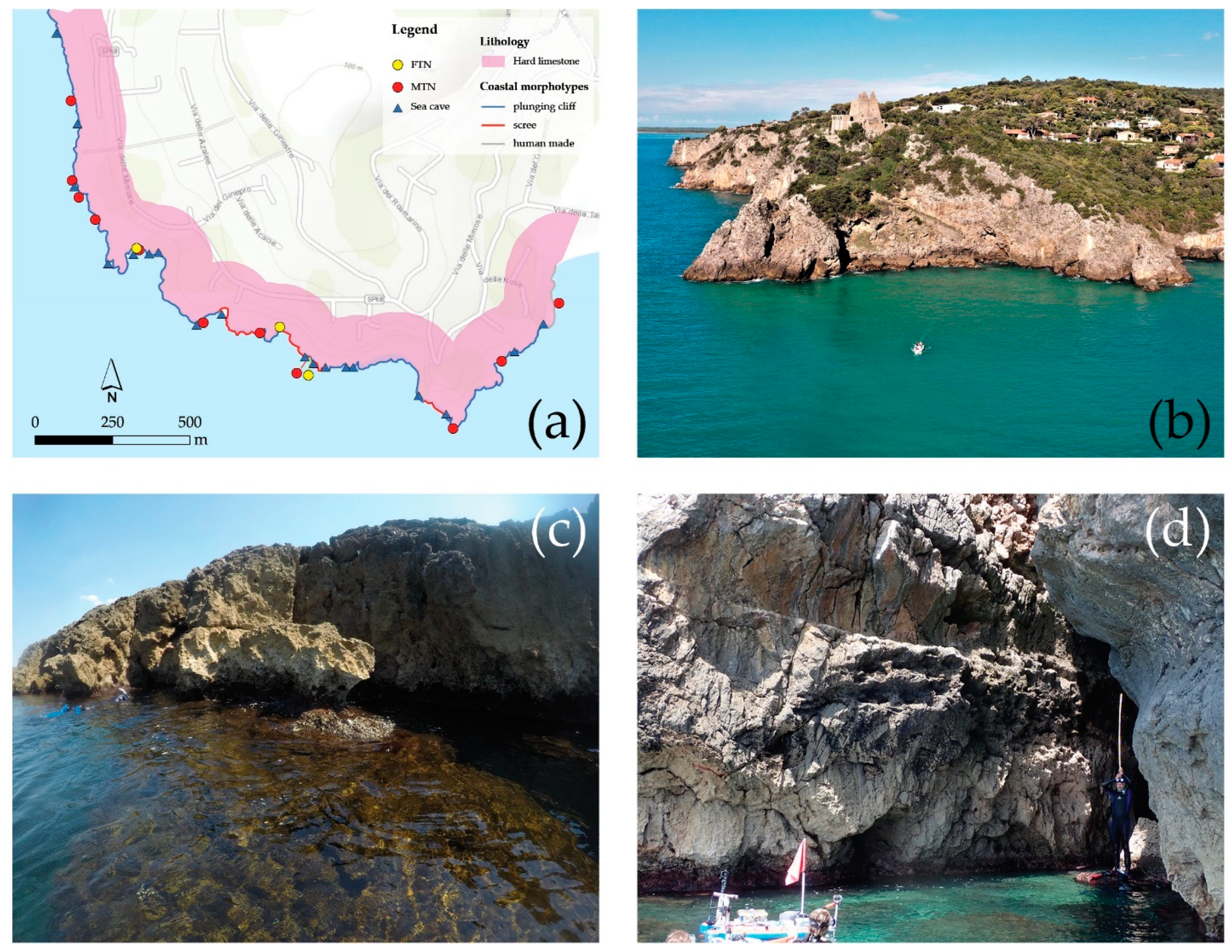
5.6. Ansedonia Promontory
6. Discussion
7. Conclusions
Author Contributions
Funding
Acknowledgments
Conflicts of Interest
Abbreviations
| LGM | Last glacial maximum |
| MTN | Modern tidal notch |
| FTN | Fossil tidal notch |
| MSP | Modern shore platform |
| FMT | Fossil marine terrace |
| ASL | Above sea level |
| BSL | Below sea level |
| LCL | Lower Coralline Limestone |
| LGL | Lower Globigerina Limestone |
| MGL | Middle Globigerina Limestone |
| UGL | Upper Globigerina Limestone |
| MIS | Marine isotope stage |
References and Note
- Anzidei, M.; Lambeck, K.; Antonioli, F.; Furlani, S.; Mastronuzzi, G.; Serpelloni, E.; Vannucci, G. Coastal Structure, Sea-Level Changes and Vertical Motion of the Land in the Mediterranean. Geol. Soc. Lond. 2014, 388, 453–479. [Google Scholar] [CrossRef]
- Furlani, S.; Ninfo, A.; Zavagno, E.; Paganini, P.; Zini, L.; Biolchi, S.; Antonioli, F.; Coren, F.; Cucchi, F. Submerged notches in Istria and the Gulf of Trieste: Results from the Geoswim Project. Quat. Int. 2014, 332, 37–47. [Google Scholar] [CrossRef]
- Rovere, A.; Raymo, M.E.; Vacchi, M.; Lorscheid, T.; Stocchi, P.; Gómez-Pujol, L.; Harris, D.L.; Casella, E.; O’Leary, M.J.; Hearty, P.J. The Analysis of Last Interglacial (MIS 5e) Relative Sea-Level Indicators: Reconstructing Sea-Level in a Warmer World. Earth-Sci. Rev. 2016, 159, 404–427. [Google Scholar] [CrossRef] [Green Version]
- Shennan, I.; Long, A.J.; Horton, B.P. Handbook of Sea-Level Research; John Wiley & Sons: Hoboken, NJ, USA, 2015. [Google Scholar]
- Benjamin, J.; Rovere, A.; Fontana, A.; Furlani, S.; Vacchi, M.; Inglis, R.H.; Galili, E.; Antonioli, F.; Sivan, D.; Miko, S.; et al. Late Quaternary Sea-Level Changes and Early Human Societies in the Central and Eastern Mediterranean Basin: An Interdisciplinary Review. Quat. Int. 2017, 449, 29–57. [Google Scholar] [CrossRef] [Green Version]
- Peltier, W.R. On Eustatic Sea Level History: Last Glacial Maximum to Holocene. Quat. Sci. Rev. 2002, 21, 377–396. [Google Scholar] [CrossRef]
- Mitrovica, J.X.; Milne, G.A. On the Origin of Late Holocene Sea-Level Highstands within Equatorial Ocean Basins. Quat. Sci. Rev. 2002, 21, 2179–2190. [Google Scholar] [CrossRef]
- Bradley, S.L.; Milne, G.A.; Horton, B.P.; Zong, Y. Modelling Sea Level Data from China and Malay-Thailand to Estimate Holocene Ice-Volume Equivalent Sea Level Change. Quat. Sci. Rev. 2016, 137, 54–68. [Google Scholar] [CrossRef] [Green Version]
- Pirazzoli, P.A.; Laborel, J.; Stiros, S.C. Earthquake Clustering in the Eastern Mediterranean during Historical Times. J. Geophys. Res. Solid Earth 1996, 101, 6083–6097. [Google Scholar] [CrossRef]
- Pirazzoli, P.A. A Review of Possible Eustatic, Isostatic and Tectonic Contributions in Eight Late-Holocene Relative Sea-Level Histories from the Mediterranean Area. Quat. Sci. Rev. 2005, 24, 1989–2001. [Google Scholar] [CrossRef]
- Lambeck, K.; Antonioli, F.; Purcell, A.; Silenzi, S. Sea-Level Change along the Italian Coast for the Past 10,000 yr. Quat. Sci. Rev. 2004, 23, 1567–1598. [Google Scholar] [CrossRef]
- Lambeck, K.; Antonioli, F.; Anzidei, M.; Ferranti, L.; Leoni, G.; Scicchitano, G.; Silenzi, S. Sea Level Change along the Italian Coast during the Holocene and Projections for the Future. Quat. Int. 2011, 232, 250–257. [Google Scholar] [CrossRef]
- Antonioli, F.; Anzidei, M.; Lambeck, K.; Auriemma, R.; Gaddi, D.; Furlani, S.; Orrù, P.; Solinas, E.; Gaspari, A.; Karinja, S.; et al. Sea-Level Change during the Holocene in Sardinia and in the Northeastern Adriatic (Central Mediterranean Sea) from Archaeological and Geomorphological Data. Quat. Sci. Rev. 2007, 26, 2463–2486. [Google Scholar] [CrossRef]
- Antonioli, F.; Lo Presti, V.; Rovere, A.; Ferranti, L.; Anzidei, M.; Furlani, S.; Mastronuzzi, G.; Orru, P.E.; Scicchitano, G.; Sannino, G.; et al. Tidal Notches in Mediterranean Sea: A Comprehensive Analysis. Quat. Sci. Rev. 2015, 119, 66–84. [Google Scholar] [CrossRef]
- Antonioli, F.; Anzidei, M.; Amorosi, A.; Lo Presti, V.; Mastronuzzi, G.; Deiana, G.; De Falco, G.; Fontana, A.; Fontolan, G.; Lisco, S.; et al. Sea-Level Rise and Potential Drowning of the Italian Coastal Plains: Flooding Risk Scenarios for 2100. Quat. Sci. Rev. 2017, 158, 29–43. [Google Scholar] [CrossRef] [Green Version]
- Padgett, J.S.; Kelsey, H.M.; Lamphear, D. Upper-Plate Deformation of Late Pleistocene Marine Terraces in the Trinidad, California, Coastal Area, Southern Cascadia Subduction Zone. Geosphere 2019, 15, 1323–1341. [Google Scholar] [CrossRef]
- Antonioli, F.; Ferranti, L.; Kershaw, S. A Glacial Isostatic Adjustment Origin for Double MIS 5.5 and Holocene Marine Notches in the Coastline of Italy. Quat. Int 2006, 145–146, 19–29. [Google Scholar] [CrossRef]
- Chemello, R.; Silenzi, S. Vermetid Reefs in the Mediterranean Sea as Archives of Sea-Level and Surface Temperature Changes. Chem. Ecol. 2011, 27, 121–127. [Google Scholar] [CrossRef] [Green Version]
- Sisma-Ventura, G.; Antonioli, F.; Silenzi, S.; Devoti, S.; Montagna, P.; Chemello, R.; Shemesh, A.; Yam, R.; Gehrels, R.; Dean, S.; et al. Assessing Vermetid Reefs as Indicators of Past Sea Levels in the Mediterranean. Mar. Geol. 2020, 429, 106–313. [Google Scholar] [CrossRef]
- Mauz, B.; Vacchi, M.; Green, A.; Hoffmann, G.; Cooper, A. Beachrock: A Tool for Reconstructing Relative Sea Level in the Far-Field. Mar. Geol. 2015, 362, 1–16. [Google Scholar] [CrossRef]
- Mourtzas, N.; Kolaiti, E. Shoreline Reconstruction of the Submerged Minoan Harbour Morphology in the Bay of Kato Zakros (Eastern Crete, Greece). J. Archaeol. Sci. Rep. 2017, 12, 684–698. [Google Scholar] [CrossRef]
- Antonioli, F.; De Falco, G.; Lo Presti, V.; Moretti, L.; Scardino, G.; Anzidei, M.; Bonaldo, D.; Carniel, S.; Leoni, G.; Furlani, S.; et al. Relative Sea-Level Rise and Potential Submersion Risk for 2100 on 16 Coastal Plains of the Mediterranean Sea. Water 2020, 12, 2173. [Google Scholar] [CrossRef]
- Auriemma, R.; Solinas, E. Archaeological Remains as Sea Level Change Markers: A Review. Quat. Int. 2009, 206, 134–146. [Google Scholar] [CrossRef]
- Furlani, S. Integrating Observational Targets and Instrumental Data on Rock Coasts through Snorkel Surveys: A Methodological Approach. Mar. Geol. 2020, 425, 106–191. [Google Scholar] [CrossRef]
- Furlani, S. The Rocky Coasts of the Mediterranean Sea: Field Studies. In Proceedings of the Coastal and Maritime Mediterranean Conference, Split, Croatia, 29 November–1 December 2017; pp. 39–44. [Google Scholar]
- Furlani, S.; Antonioli, F.; Gambin, T.; Gauci, R.; Ninfo, A.; Zavagno, E.; Micallef, A.; Cucchi, F. Marine Notches in the Maltese Islands (Central Mediterranean Sea). Quat. Int. 2017, 439, 158–168. [Google Scholar] [CrossRef] [Green Version]
- Furlani, S.; Pappalardo, M.; Gómez-Pujol, L.; Chelli, A. The rock coast of the Mediterranean and Black Seas. In Geological Society; London, Memoirs: London, UK, 2014; Volume 40, pp. 89–122. [Google Scholar]
- Biolchi, S.; Furlani, S.; Devoto, S.; Gauci, R.; Castaldini, D.; Soldati, M. Geomorphological Identification, Classification and Spatial Distribution of Coastal Landforms of Malta (Mediterranean Sea). J. Maps 2016, 12, 87–99. [Google Scholar] [CrossRef] [Green Version]
- Biolchi, S.; Furlani, S.; Antonioli, F.; Baldassini, N.; Causon Deguara, J.; Devoto, S.; Di Stefano, A.; Evans, J.; Gambin, T.; Gauci, R.; et al. Boulder Accumulations Related to Extreme Wave Events on the Eastern Coast of Malta. Nat. Hazards Earth Syst. Sci. 2016, 16, 737–756. [Google Scholar] [CrossRef] [Green Version]
- Mather, A. The Physical Geography of the Mediterranean; OUP Oxford: Oxford, UK, 2009; ISBN 978-0-19-160841-4. [Google Scholar]
- International Hydrographic Organization (IHO); Sieger, R. Names of Oceans and Seas as Digitized Table. Alfred Wegener Institute, Helmholtz Centre for Polar and Marine Research, Bremerhaven, PANGAEA. 2012. Available online: https://doi.org/10.1594/PANGAEA.777976 (accessed on 25 July 2021).
- Mastronuzzi, G.; Antonioli, F.; Anzidei, M.; Auriemma, R.; Alfonso, C.; Scarano, T. Evidence of Relative Sea Level Rise along the Coasts of Central Apulia (Italy) during the Late Holocene via Maritime Archaeological Indicators. Quat. Int. 2017, 439, 65–78. [Google Scholar] [CrossRef]
- Selli, R. Appunti Sulla Geologia Del Mar Tirreno. Rendiconti Semin. Fac Sci Univ Cagliari 1974, 327–349. [Google Scholar]
- Malinverno, A.; Ryan, W.B.F. Extension in the Tyrrhenian Sea and Shortening in the Apennines as Result of Arc Migration Driven by Sinking of the Lithosphere. Tectonics 1986, 5, 227–245. [Google Scholar] [CrossRef]
- Kastens, K.; Mascle, J.; Auroux, C.; Bonatti, E.; Broglia, C.; Channell, J.; Curzi, P.; Emeis, K.-C.; Glaçon, G.; Hasegawa, S.; et al. ODP Leg 107 in the Tyrrhenian Sea: Insights into Passive Margin and Back-Arc Basin Evolution. GSA Bull. 1988, 100, 1140–1156. [Google Scholar] [CrossRef]
- Selli, R. Cenni Morfologici Generali Sul Mar Tirreno. G Geol. 1970, 37, 5–24. [Google Scholar]
- Chiocci, F.L.; D’Angelo, S.; Romagnoli, C. Atlante Dei Terrazzi Deposizionali Sommersi Lungo Le Coste Italiane. Mem. Descr. Della Carta Geol. D’Italia 2004, 58, 197. [Google Scholar]
- Catalano, S.; Torrisi, S.; Tortorici, G.; Romagnoli, G. Active Folding along a Rift-Flank: The Catania Region Case History (SE Sicily). J. Geodyn. 2011, 51, 53–63. [Google Scholar] [CrossRef] [Green Version]
- Gasparo Morticelli, M.; Valenti, V.; Catalano, R.; Sulli, A.; Agate, M.; Avellone, G.; Albanese, C.; Basilone, L.; Gugliotta, C. Deep Controls on Foreland Basin System Evolution along the Sicilian Fold and Thrust Belt. Bull. Soc. Geol. Fr. 2015, 186, 273–290. [Google Scholar] [CrossRef]
- GEBCO. The General Bathymetric Chart of the Oceans. Available online: https://www.gebco.net/ (accessed on 9 June 2021).
- Bigi, G.; Cosentino, D.; Parotto, M.; Sartori, R.; Scandone, P. Structural Model of Italy 1:500,000. CNR Progetto Final. Geodin. 1992, 3, 114. [Google Scholar]
- Sulli, A.; Morticelli, M.G.; Agate, M.; Zizzo, E. Active North-Vergent Thrusting in the Northern Sicily Continental Margin in the Frame of the Quaternary Evolution of the Sicilian Collisional System. Tectonophysics 2021, 802, 228717. [Google Scholar] [CrossRef]
- Max, M.D.; Kristensen, A.; Michelozzi, E. Small Scale Plio-Quaternary Sequence Stratigraphy and Shallow Geology of the West-Central Malta Plateau. Geol. Dev. Sicil. Tunis. Platf. 1993, 58, 117–122. [Google Scholar]
- Micallef, A.; Camerlenghi, A.; Georgiopoulou, A.; Garcia-Castellanos, D.; Gutscher, M.-A.; Lo Iacono, C.; Huvenne, V.A.I.; Mountjoy, J.J.; Paull, C.K.; Le Bas, T.; et al. Geomorphic Evolution of the Malta Escarpment and Implications for the Messinian Evaporative Drawdown in the Eastern Mediterranean Sea. Geomorphology 2019, 327, 264–283. [Google Scholar] [CrossRef]
- Gauci, R.; Scerri, S. A Synthesis of Different Geomorphological Landscapes on the Maltese Islands. In Landscapes and Landforms of the Maltese Islands; Gauci, R., Schembri, J.A., Eds.; World Geomorphological Landscapes Springer: Cham, Switzerland, 2019; pp. 49–65. [Google Scholar]
- Alexander, D. A Review of the Physical Geography of Malta and Its Significance for Tectonic Geomorphology. Quat. Sci. Rev. 1988, 7, 41–53. [Google Scholar] [CrossRef]
- Pedley, M. The Calabrian Stage, Pleistocene Highstand in Malta: A New Marker for Unravelling the Late Neogene and Quaternary History of the Islands. J. Geol. Soc. 2011, 168, 913–926. [Google Scholar] [CrossRef]
- Rohling, E.J.; Abu-Zied, R.; Casford, C.S.L.; Hayes, A.; Hoogakker, B.A.A. The Mediterranean Sea: Present and Past. In Physical Geography of the Mediterranean Basin; Oxford Regional Environments; Oxford University Press: Oxford, UK, 2009; ISBN 978-0-19-926803-0. [Google Scholar]
- McElderry, J.H. Mediterranean Tides and Currents. Ir. Astron. J. 1963, 6, 12. [Google Scholar]
- Pinet, P.R. Invitation to Oceanography; West Publishing Co: St. Paul, MN, USA, 1996. [Google Scholar]
- Izquierdo, A.; Mikolajewicz, U. The Role of Tides in the Spreading of Mediterranean Outflow Waters along the Southwestern Iberian Margin. Ocean Model. 2019, 133, 27–43. [Google Scholar] [CrossRef]
- Burbank, D.W.; Anderson, R.S. Tectonic Geomorphology; John Wiley & Sons: Hoboken, NJ, USA, 2009; ISBN 978-1-4443-1311-6. [Google Scholar]
- Sunamura, T. The Elevation of Shore Platforms: A Laboratory Approach to the Unsolved Problem. J. Geol. 1991, 99, 761–766. [Google Scholar] [CrossRef]
- Trenhaile, A.S. Coastal Notches: Their Morphology, Formation, and Function. Earth Sci. Rev. 2015, 150, 285–304. [Google Scholar] [CrossRef]
- Antonioli, F.; Ferranti, L.; Stocchi, P.; Deiana, G.; Lo Presti, V.; Furlani, S.; Marino, C.; Orru, P.; Scicchitano, G.; Trainito, E.; et al. Morphometry and Elevation of the Last Interglacial Tidal Notches in Tectonically Stable Coasts of the Mediterranean Sea. Earth Sci. Rev. 2018, 185, 600–623. [Google Scholar]
- Trenhaile, A.S. The Geomorphology of Rock Coasts; Clarendon Press: Budapest, Hungary, 1987. [Google Scholar]
- Antonioli, F.; Furlani, S.; Montagna, P.; Stocchi, P. The Use of Submerged Speleothems for Sea Level Studies in the Mediterranean Sea: A New Perspective Using Glacial Isostatic Adjustment (GIA). Geosciences 2021, 11, 77. [Google Scholar] [CrossRef]
- Furlani, S.; Cucchi, F.; Biolchi, S. Late Holocene widening of karst voids by marine processes in partially submerged coastal caves (northeastern Adriatic sea). Geogr. Fis. E Din. Quat. 2012, 35, 129–140. [Google Scholar]
- De Waele, J.; Furlani, S. Seawater and Biokarst Effects on Coastal Limestones. In Treatise on Geomorphology; Shroder, J.F., Ed.; Academic Press: San Diego, CA, USA, 2013; Volume 6, pp. 341–350. [Google Scholar]
- Sunamura, T. Geomorphology of Rocky Coasts; John Wiley & Sons: Chichester, UK, 1992; ISBN 0471917753. [Google Scholar]
- Mylroie, J.E.; Carew, J.L. The Flank Margin Model for Dissolution Cave Development in Carbonate Platforms. Earth Surf. Process. Landf. 1990, 15, 413–424. [Google Scholar] [CrossRef]
- Antonioli, F.; Chemello, R.; Improta, S.; Riggio, S. Dendropoma Lower Intertidal Reef Formations and Their Palaeoclimatological Significance, NW Sicily. Mar. Geol. 1999, 161, 155–170. [Google Scholar] [CrossRef]
- Chemello, R. La Bionomia Bentonica Ed i Molluschi. Il Piano Infralitorale: Il Marciapiede a Vermeti. Not. SIM 1989, 7, 167–170. [Google Scholar]
- Chemello, R.; Pandolfo, A.; Riggio, S. Le Biocostruzioni a Molluschi Vermetidi Nella Sicilia Nord-Occidentale. In Proceedings of the Atti 53 Congresso UZI 1990, Palermo, Italy, 1–5 October 1990. [Google Scholar]
- Chemello, R. Le Biocostruzioni Marine in Mediterraneo. Lo Stato Delle Conoscenze Sui Reef a Vermeti. Biol. Mar. Mediterr. 2009, 16, 2–18. [Google Scholar]
- Consoli, P.; Romeo, T.; Giongrandi, U.; Andaloro, F. Differences among Fish Assemblages Associated with a Nearshore Vermetid Reef and Two Other Rocky Habitats along the Shores of Cape Milazzo (Northern Sicily, Central Mediterranean Sea). Mar. Biol. Assoc. U. K. J. 2008, 88, 401–410. [Google Scholar] [CrossRef]
- Milazzo, M.; Fine, M.; La Marca, E.C.; Alessi, C.; Chemello, R. Drawing the Line at Neglected Marine Ecosystems: Ecology of Vermetid Reefs in a Changing Ocean. Mar. Anim. For. 2016, 120, 1–23. [Google Scholar]
- Sea Level Station Monitoring Facility. Available online: http://www.ioc-sealevelmonitoring.org/map.php (accessed on 17 June 2021).
- Egbert, G.D.; Erofeeva, S.Y. Efficient Inverse Modeling of Barotropic Ocean Tides. J. Atmospheric Ocean. Technol. 2002, 19, 183–204. [Google Scholar] [CrossRef] [Green Version]
- Carobene, L. Osservazioni sui solchi di battente attuali ed antichi nel golfo di Oresei in Sardegna. Mem. Soc. Geol. It. 1972, 19, 641–649. [Google Scholar]
- Carobene, L. Pasini Contributo Alla Conscenza Del Pleistocene Superiore e Dell’Olocene Del Golfo Di Orosei (Sadegna Orientale). Boll. Della Soc. Adriat. Sci. 1980, 114, 5–36. [Google Scholar]
- Furlani, S.; Cucchi, F.; Biolchi, S.; Odorico, R. Notches in the Northern Adriatic Sea: Genesis and Development. Quat. Int. 2011, 232, 158–168. [Google Scholar] [CrossRef]
- Abate, B.; Incandela, A.; Renda, P. Carta Geologica delle Isole di Favignana e Levanzo. Diploma Thesis, Di Geologia e Geodesia dell’Università degli Studi di Palermo, Palermo, Italy, 1997. [Google Scholar]
- Cardello, G.L. Rilevamento Geologico del Promontorio del Circeo: Analisi di Facies ed Evoluzione Tettono-Stratigrafica. Master’s Thesis, University of Rome “La Sapienza”, Rome, Italy, 2006. [Google Scholar]
- Rossi, D.; Bigi, S.; Del Castello, M.; Di Manna, P. The Structure of the Aurunci Mountains (Southern Lazio): A Balanced Cross-Section and Its Restoration. Boll. Della Soc. Geol. Ital. Vol. Spec. 2002, 1, 151–159. [Google Scholar]
- Regione Toscana. Available online: https://www.regione.toscana.it/ (accessed on 17 June 2021).
- Miragoli, M. Le Grotte Delle Egadi, Contributo Aggiuntivo.; Catania, Sicily, 11th December 1994; Vol. Boll Acc. Gioenia di Sc. Nat. 1994, pp. 413–429. Available online: https://www.biodiversitylibrary.org/bibliography/6339 (accessed on 25 July 2021).
- Antonioli, F.; Lo Presti, V.; Morticelli, M.G.; Bonfiglio, L.; Mannino, M.A.; Palombo, M.R.; Sannino, G.; Ferranti, L.; Furlani, S.; Lambeck, K.; et al. Timing of the Emergence of the Europe–Sicily Bridge (40–17 Cal Ka BP) and Its Implications for the Spread of Modern Humans. Geol. Soc. Lond. Spec. Publ. 2016, 411, 111–144. [Google Scholar] [CrossRef]
- Laborel, J.; Morhange, C.; Lafont, R.; Le Campion, J.; Laborel-Deguen, F.; Sartoretto, S. Biological Evidence of Sea-Level Rise during the Last 4500 Years on the Rocky Coasts of Continental Southwestern France and Corsica. Mar. Geol. 1994, 120, 203–223. [Google Scholar] [CrossRef]
- Laborel, J.; Laborel-Deguen, F. Biological Indicators of Relative Sea-Level Variations and of Co-Seismic Displacements in the Mediterranean Region. J. Coast. Res. 1994, 10, 395–415. [Google Scholar]
- Segre, A.G. Nota Sui Rilevamenti Eseguiti Nel Foglio 158 Latina Della Carta Geologica d’Italia; Tip. del Senato del dott. G. Bardi, 1957.
- Bietti, A.; Grimaldi, S. Small Flint Pebbles and Mousterian Reduction Chains: The Case of Southern Latium (Italy). Quaternaria Nova 1996, 6, 237–260. [Google Scholar]
- Durante, S. Il Tirreniano e Malacofauna Della Grotta Fossellone (Circeo). 1974. Available online: http://pascal-francis.inist.fr/vibad/index.php?action=getRecordDetail&idt=PASCALGEODEBRGM7720220288 (accessed on 25 July 2021).
- Mottershead, D.; Bray, M.; Causon Deguara, J. Tsunamigenic Landscapes in the Maltese Islands: The Comino Channel Coasts. In Landscapes and Landforms of the Maltese Islands; Gauci, R., Schembri, J.A., Eds.; World Geomorphological Landscapes; Springer International Publishing: Cham, Switzerland, 2019; pp. 273–288. [Google Scholar]
- Galve, J.P.; Tonelli, C.; Gutiérrez, F.; Lugli, S.; Vescogni, A.; Soldati, M. New Insights into the Genesis of the Miocene Collapse Structures of the Island of Gozo (Malta, Central Mediterranean Sea). J. Geol. Soc. 2015, 172, 336–348. [Google Scholar] [CrossRef] [Green Version]
- Azzopardi, L.; Schembri, P. Vermetid Crusts from the Maltese Islands (Central Mediterranean). Mar. Life 1997, 7, 7–16. [Google Scholar]
- Soldati, M.; Tonelli, C.; Galve, J.P. Geomorphological Evolution of Palaeo-sinkhole Features in the Maltese Archipelago (Mediterranean Sea). Geogr. Fis. E Din. Quat. 2013, 36, 189–198. [Google Scholar]
- Ferranti, L.; Antonioli, F.; Mauz, B.; Amorosi, A.; Dai Pra, G.; Mastronuzzi, G.; Monaco, C.; Orrù, P.; Pappalardo, M.; Radtke, U.; et al. Markers of the Last Interglacial Sea-Level High Stand along the Coast of Italy: Tectonic Implications. Quat. Int. 2006, 145–146, 30–54. [Google Scholar] [CrossRef]
- Furlani, S.; Cucchi, F.; Forti, F.; Rossi, A. Comparison between Coastal and Inland Karst Limestone Lowering Rates in the Northeastern Adriatic Region (Italy and Croatia). Geomorphology 2009, 104, 73–81. [Google Scholar] [CrossRef]
- Furlani, S.; Cucchi, F. Downwearing Rates of Vertical Limestone Surfaces in the Intertidal Zone (Gulf of Trieste, Italy). Mar. Geol. 2013, 343, 92–98. [Google Scholar] [CrossRef]
- Gauci, R. The Identification and Quantification of Surface Change on Limestone Shore Platforms of the Maltese Islands. Ph.D Thesis, University of Portsmouth, Portsmouth, UK, 2018. [Google Scholar]
- Gauci, R.; Inkpen, R. The Physical Characteristics of Limestone Shore Platforms on the Maltese Islands and Their Neglected Contribution to Coastal Land Use Development. In Landscapes and Landforms of the Maltese Islands; Gauci, R., Schembri, J.A., Eds.; World Geomorphological Landscapes; Springer International Publishing: Cham, Switzerland, 2019; pp. 343–356. [Google Scholar]
- Stephenson, W.J.; Dickson, M.E.; Trenhaile, A.S. Rock Coasts. In Treatise on Geomorphology; Shroder, J.F., Ed.; Academic Press: San Diego, CA, USA, 2013; Volume 10, pp. 289–307. [Google Scholar]
- Paskoff, R.; Sanlaville, P. Geomorphologic Observations on Maltese Archipelago Coasts. Z Geomorph 1978, 310–328. [Google Scholar]
- Furlani, S.; Antonioli, F.; Biolchi, S.; Gambin, T.; Gauci, R.; Lo Presti, V.; Anzidei, M.; Devoto, S.; Palombo, M.R.; Sulli, A. Reply to Comment by C. Morhange, C. Flaux, P.A. Pirazzoli, M.B. Carre on “Holocene Sea Level Change in Malta”. Quat. Int. 2013, 303, 235–236. [Google Scholar] [CrossRef] [Green Version]
- Gauci, R.; Schembri, J.A. Landscapes and Landforms of the Maltese Islands; World Geomorphological Landscapes; Springer: Cham, Switzerland, 2019. [Google Scholar]
- Presti, V.L.; Antonioli, F.; Palombo, M.R.; Agnesi, V.; Biolchi, S.; Calcagnile, L.; Di Patti, C.; Donati, S.; Furlani, S.; Merizzi, J.; et al. Palaeogeographical Evolution of the Egadi Islands (Western Sicily, Italy). Implications for Late Pleistocene and Early Holocene Sea Crossings by Humans and Other Mammals in the Western Mediterranean. Earth Sci. Rev. 2019, 194, 160–181. [Google Scholar] [CrossRef]


| A Site No. | B Year | C Location | D Number of Surveyors | E Type of Rocks | F Type of Survey | G Total Length of the Route (km) | H Days of Survey |
|---|---|---|---|---|---|---|---|
| 1 (par. 4.2.1) | 2014 | Egadi Islands (Italy) | 7 | Calcarenites, dolomites, limestones | Snorkelling | 63.5 | 7 |
| 2 (par. 4.2.2) | 2014 | Gaeta Promontory (Latium, Italy) | 4 | Hard limestones | Snorkelling | 3.1 | 1 |
| 3 (4.2.3) | 2014 | Circeo Promontory (Latium, Italy) | 2 | Hard limestones | Kayaking | 8.1 | 1 |
| 4 (par. 4.2.4) | 2015 | Razzoli, Budelli, Santa Maria (Sardinia, Italy) | 7 | Igneous rocks | Snorkelling | 26.3 | 3 |
| 5 (par. 4.2.5) | 2015 | Capo Caccia (Sardinia, Italy) | 6 | Soft to hard limestones, marlstone, dolomites | Snorkelling | 14.6 | 2 |
| 6 (par. 4.2.6) | 2015 | Tavolara (Sardinia, Italy) | 7 | Dolomites and hard limestones, igneous rocks | Snorkelling | 13.5 | 2 |
| 7 (par. 4.2.7) | 2015 | Malta E (Malta) | 7 | Soft to hard limestones, calcarenites | Snorkelling | 19.5 | 3 |
| 8 (par. 4.2.8) | 2016 | Mondello-Palermo (Sicily, Italy) | 5 | Soft limestones, calcarenites, hard limestones | Snorkelling | 6.4 | 1 |
| 9 (par. 4.2.9) | 2018 | Ansedonia (Tuscany, Italy) | 7 | Hard limestones | Snorkelling | 3.4 | 2 |
| TOTAL | 22 | 158.5 | 22 |
| A Site No. | B Location | C Type of Rocks | D Total Length (m) | E MTN (m) | F Coverage (%) | G FTN (Y/N) | H Coverage (%) | L Altitude of the FTN (m ASLASL) | G Type of Data | H Vermetid Structures (Y/N) | I Coverage (%) | L Sea Caves (n) |
|---|---|---|---|---|---|---|---|---|---|---|---|---|
| 1 | Marettimo Island | Limestones, dolomites, siltite, breccias | 19,300 | 10,300 | 53.4 | 45 | 0.2 | 8.10 ± 0.2 | Video, estimated length | 5641 | 29.2 | 17 |
| 2 | Favignana Island | Limestones, dolomites, breccias, siltite | 32,200 | 7350 | 22.8 | 0 | 0.0 | / | Video, estimated length | 26,034 | 80.9 | 16 |
| 3 | Levanzo Island | Limestones, dolomites, siltite, breccias | 12,000 | 750 | 6.3 | 80 | 0.7 | 8.50 ± 0.3 | Video, estimated length | 13,256 | 93.0 | 4 |
| 4 | Gaeta Promontory | Limestones | 3115 | 3043 | 97.7 | 28 | 0.9 | 5.92 ± 0.3 | Video, measured length | 0 | / | 11 |
| 5 | Circeo Promontory | Limestones | 8154 | 0 | 0.0 | 80 | 1.0 | 9.28 ± 0.2 | Video, estimated length | 0 | / | 8 |
| 6 | Razzoli, Budelli, Santa Maria Islands | Granites, local calcarenite outcrops | 26,300 | 20 | 0.1 | 0 | 0.0 | / | Time-lapse images, estimated length | 0 | / | 0 |
| 7 | Capo Caccia | Limestones | 14,600 | 12500 | 85.6 | 210 | 1.4 | 3.10–4.25 ± 0.03 | Time-lapse images, measured length | 0 | / | 22 |
| 8 | Tavolara Island | Limestones, granites | 13,500 | 8516 | 63.1 | 150 | 1.1 | 6.05–7.08 ± 0.15 | Time-lapse images, measured length | 0 | / | 8 |
| 9 | Malta Island (East) | Limestones | 19,500 | 2240 | 11.5 | 0 | 0.0 | / | Time-lapse images | 2050 ** | / | 19 |
| 10 | Mondello-Palermo | Limestones, breccias | 6453 | 1300 | 20.1 | 0 | 0.0 | / | Time-lapse images, measured length | 857 | 10.5 | 8 |
| 11 | Ansedonia | Limestones, breccias, dolomites | 3390 | 1368 | 40.4 | 10 | 0.3 | 4.5 ± 0.50 | Time-lapse images, video, measured length | 0 | 13.3 | 20 |
| Site | Photo No. | MTN Width (cm) | MTN Depth (cm) | MTN Bottom Depth (cm) | Depth of Cliff Toe (cm) | Freshwater Spring (Y/N) | Lithology | Notes |
|---|---|---|---|---|---|---|---|---|
| 1 | 1 | 39 | 78 | 38 | 112 | N | limestone | Pebbles 1–2 cm in size at submerged cliff toe. |
| 2 | - | 41 | 65 | 65 | 139 | N | limestone | Pebbles 10 cm in size at submerged cliff toe. |
| 3 | 2 | 43 | 174 | 76 | 165 | N | limestone | - |
| 4 | - | 45 | - | - | - | N | limestone | - |
| 5 | - | 44 | 78 | 84 | 147 | N | limestone | - |
| 6 | - | 42 | 104 | 95 | 260 | N | limestone conglomerate | MTN base lays 0.12 m ASL. Dissolution forms and conglomerates within the notch. |
| 7 | - | 52 | 73 | 139 | 188 | N | conglomerate | Blocks 10 cm in size at the sea bottom due to recent collapse phenomena. |
| 8 | - | 50 | 73 | 57 | >200 | N | conglomerate | The base of the MTN lays 1 cm BSL. |
| 9 | - | 48 | 150 | 67 | >200 | N | limestone | The base of the MTN lays 5 cm ASL. |
| 10 | - | 49 | 127 | 71 | >300 | N | limestone | The base of the MTN is 10 cm ASL. |
| 11 | - | - | - | - | - | N | limestone | A stack occurs just in front of the site, and could be responsible for the absence of MTN. |
| 12 | - | - | - | - | - | N | limestone and conglomerate | Submerged platform. |
| 13 | - | 37 | 95 | 18 | 300 | N | conglomerate | Small emerged platform, cut in limestones and conglomerates. The presence of boulders distorts the depth of the sea bed. |
| 14 | 3 | 45 | 70 | 100 | 300 | N | conglomerate | Conglomerates and platform 20 cm higher than mean tide |
| 15 | 4–5 | 42 | 130 | 75 | 350 | N | conglomerate | The base of the MTN is 15 cm ASL. |
| 16 | 6–7 | ~45 | - | - | - | N | conglomerate | Large and small barnacles within the MTN. Platform collapse, presence of boulders, no MTN. |
| 17 | 8–9 | 49 | 137 | 118 | 300 | N | conglomerate | The base of the MTN is 15 cm ASL. |
| 18 | 10–11 | 48 | 152 | 30 | 300 | Y | conglomerate and limestone | The base of the MTN does not always occur. There are large blocks below the sea level, and large balanids. |
| 19 | - | 40 | 152 | 46 | 300 | Y | conglomerate and limestone | The coast is plunging with a large freshwater spring. |
| 20 | - | 48 | 107 | 82 | 350 | Y | conglomerate and limestone | Calcareous red algae inside the notch. There are several sea caves below the base of the notch, and a large freshwater spring. |
| 21 | 12–14 | 44 | 143 | 78 | 250 | Y | conglomerate and limestone | Fossils of cervids and pulmonates. The MTN is partly collapsed. |
| 22 | - | 44 | 135 | 74 | 350 | Y | conglomerate and limestone | Red continental deposits seal Lithophaga holes containing pulmonata and cervid bones. |
| 23 | 15–17, 19 | 43 | 140 | 54 | 20 | N | limestone | Medium–large balanids replace corallinae algae. |
| 24 | 18 | 45 | 109 | 58 | 40 | N | limestone | |
| 25 | 20–22 | 41 | 220 | 65 | 100 | Y | limestone | The sea level is 10–12 cm higher than the starting point, and the base of the notch was roughly at sea level. A spectacular mushroom-like rock, 6 × 4 m in size and up to 2 m ASL in height. A slightly submerged platform lays all around the aforementioned landform. Limpets were found inside the notch. |
| Mean value | 44,3 | 119.6 | 70.9 | 220.6 |
Publisher’s Note: MDPI stays neutral with regard to jurisdictional claims in published maps and institutional affiliations. |
© 2021 by the authors. Licensee MDPI, Basel, Switzerland. This article is an open access article distributed under the terms and conditions of the Creative Commons Attribution (CC BY) license (https://creativecommons.org/licenses/by/4.0/).
Share and Cite
Furlani, S.; Vaccher, V.; Antonioli, F.; Agate, M.; Biolchi, S.; Boccali, C.; Busetti, A.; Caldareri, F.; Canziani, F.; Chemello, R.; et al. Preservation of Modern and MIS 5.5 Erosional Landforms and Biological Structures as Sea Level Markers: A Matter of Luck? Water 2021, 13, 2127. https://doi.org/10.3390/w13152127
Furlani S, Vaccher V, Antonioli F, Agate M, Biolchi S, Boccali C, Busetti A, Caldareri F, Canziani F, Chemello R, et al. Preservation of Modern and MIS 5.5 Erosional Landforms and Biological Structures as Sea Level Markers: A Matter of Luck? Water. 2021; 13(15):2127. https://doi.org/10.3390/w13152127
Chicago/Turabian StyleFurlani, Stefano, Valeria Vaccher, Fabrizio Antonioli, Mauro Agate, Sara Biolchi, Chiara Boccali, Alice Busetti, Francesco Caldareri, Fabio Canziani, Renato Chemello, and et al. 2021. "Preservation of Modern and MIS 5.5 Erosional Landforms and Biological Structures as Sea Level Markers: A Matter of Luck?" Water 13, no. 15: 2127. https://doi.org/10.3390/w13152127