
Landscape Preferences of Visitors to the Danube Floodplains National Park, Vienna


1
Institute of Landscape Development, Recreation and Conservation Planning, University of Natural Resources and Life Sciences Vienna, Peter Jordan-Straße 82, 1190 Vienna, Austria
2
Institute of Hydrobiology and Aquatic Ecosystem Management, University of Natural Resources and Life Sciences Vienna, Gregor Mendel Str. 33, 1180 Vienna, Austria
3
AG BIGER, WasserCluster Lunz–biologische Station, Dr. Carl Kupelwieser Prom. 5, 3293 Lunz, Austria
4
Institute of Wildlife Biology and Game Management, University of Natural Resources and Life Sciences Vienna, Gregor Mendel Str. 33, 1180 Vienna, Austria
*
Author to whom correspondence should be addressed.
Water 2021, 13(16), 2178; https://doi.org/10.3390/w13162178
Submission received: 7 July 2021
/
Revised: 26 July 2021
/
Accepted: 30 July 2021
/
Published: 9 August 2021
(This article belongs to the Special Issue The Blue Economy: Evaluating the Human Benefits from and Pressures on Marine and Coastal Environments)
Abstract
:Successfully managing heavily visited protected riverscapes requires information about visitor preferences for the social, biophysical and infrastructural attributes of river landscapes. This study analyzed the landscape preferences of 520 on-site visitors to the peri-urban Danube Floodplains National Park using an image-based discrete choice experiment. The study explored the effects of various landscape types (water bodies, terrestrial landscapes), recreational infrastructures (trail types, facilities) and trail use conditions (trail user numbers, activities) on respondents’ preferences. The results indicated that natural features, such as floodplain forests in combination with meadows or xeric alluvial biotopes, were preferred, while dense forests and, particularly, open agrarian structures were less preferred. Water bodies with 50% reed cover, few people on the trail, alleys of trees and gravel trails were favored. The outcomes serve as the basis for design recommendations for planned recreational areas surrounding the national park with the aim of absorbing visitors and reducing use pressure on the protected area.
1. Introduction
Riverscapes provide a range of ecosystem services to society. They are hotspots for biodiversity, deliver drinking water and food, regulate flood risks and are important for outdoor recreation and nature-based tourism [1,2,3]. Urban riverscapes are specifically under pressure not only because of urban development, but also due to the heavy recreation uses often exceeding ecological and social carrying capacities. Successfully managing heavily visited protected riverscapes requires information about perceived visitor benefits and preferences for river landscapes. Knowledge of visitor preferences is also important for riverine landscape development. Whereas previous research has often addressed human preferences for river landscapes, little research has analyzed whether and how the biophysical, social and infrastructural attributes of riverscapes correspond to visitor aesthetic preferences [4,5,6]. A more comprehensive approach of this kind is particularly important for the urban context, as recreation uses are characterized by high visitor densities, diverse visitor activities and behaviors, and various recreational infrastructures.
1.1. Human Preferences for River Landscapes
Landscape preference theories suggest that humans favor landscapes that afford the basic needs for survival. Water plays a crucial role in human survival, and humans thus prefer landscapes with water bodies [7]. The landscape preference theories also assert that semi-open landscapes, which were characteristic of the African savanna environments of human origin, are preferred over very densely forested or wide-open landscapes [7,8]. Research on aesthetic assessments of rivers has often addressed river restoration measures [9], riparian vegetation, river flow preferences, river planform [8,10], wood in rivers [11,12] and water quality [13,14]. Research has demonstrated that humans prefer larger bodies of open water, natural river landscapes and fast-moving streams. They prefer river landscapes that create a feeling of safety and satisfy human recreational needs [5]. In contrast, humans dislike swampy wetlands, dead wood in rivers, algae blooms, muddy water and waterways filled with litter and debris [9,14].
1.2. Human Preferences for Recreational Trail Environments
Whereas some research exists on preferred recreational trail qualities in terms of trail surface and width, little is known about preferences for trail qualities in riverscapes and specific recreational offers or signage. Research on trail width has shown that preferences depend on the activity type. Hikers prefer trails that are about 2 m wide, while they dislike broader and narrower trail types. Bicyclists prefer broader trails than hikers [15,16,17,18].
Studies on trail surfaces have found that gravel or natural trails are preferred to asphalt ones, and natural trails are preferred to gravel trails [15,16,18]. Litter or dog feces on the trail are disliked [4,15], while a natural trail with few puddles is preferred [16]. Regarding signage, Arnberger et al. [16] found support for trail signage by national park visitors.
1.3. Human Preferences for Social Conditions on Recreational Trails
Crowding perceptions, preferences for visitor use levels, visitor activities and behaviors also must be considered when assessing preferences for riverscapes. Crowding is reported when the social stimulation exceeds the preferred level of contacts with other visitors [19]. Many studies have found that visitors to natural areas prefer low use levels [18,19,20,21,22]. Recreation research has often analyzed water-based river recreation use such as canoeing or kayaking [19,22,23,24], while studies on preferences for visitor use levels of terrestrial riverscape visitors are rare. The majority of water-based recreational studies have found that water-based users prefer low use levels. Regarding terrestrial recreation use in riverscapes, Arnberger, Aikoh, Eder, Shoji and Mieno [20], and Eder and Arnberger [25] observed that visitors prefer low use levels, and perceptions of overcrowding were widespread among visitors to urban riverscapes.
1.4. Research Questions
Most studies on the aesthetics of rivers have either focused on the river corridor itself or concentrated on single elements of riverscapes, but these studies have not investigated the areas typical for natural floodplains nor analyzed the role of tradeoffs between biophysical, social and infrastructural river landscape elements on human preferences. Central European floodplains consist of alluvial forests areas, xeric alluvial biotopes or succession areas, and water bodies of diverse sizes that are subject to different water regimes [26]. In addition, these areas are used by humans for recreation purposes and economic activities, such as nature-based tourism and agriculture. Meadows and fields, as well as various types of recreation infrastructures, can be found in these areas. Therefore, this study used an approach integrating different landscape elements for a more holistic assessment of riverscape preferences. An image-based discrete choice experiment (DCE) was used to understand how people weigh and trade off multiple attributes relevant to their landscape preferences [27]. DCEs are rooted in the traditional microeconomic theory of consumer behavior and preference theory [28]. In a DCE, two or more hypothetical alternatives of landscapes are combined into choice sets, and respondents choose the most or least preferred alternative from each set [27]. The selection of one alternative over the other implies that the utility of that alternative is greater than the utility of any other alternative [28]. Random utility theory postulates that respondents’ choices can be modelled as a function of the factors of the alternatives [29]. This approach makes it possible to identify the most and least preferred features of a diverse and complex river landscape and its surrounding area.
The results of such holistic assessments of riverscape preferences are useful for designing guidelines for attractive recreational riverscape areas. The case study area, the Lobau, is part of the Danube Floodplains National Park, and is located in Vienna, Austria. The continuing housing development for tens of thousands of new residents, which is taking place in the vicinity, is expected to impact the nearby protected alluvial forest area. The Lobau is already heavily used, and the urban development will further increase the high recreation use pressure [30]. This pressure will not only negatively impact the park’s natural resources, but also the quality of the recreational experience, due to crowding and user conflicts [20,25]. Providing alternative recreation areas in the surrounding area, the so-called “Lobau foreland,” may absorb—and thus partially deflect—use pressure from the national park. The overall planning scenario involves transforming the existing large-scale agrarian-dominated areas surrounding the protected area into attractive recreational landscapes. The blue spaces of the Lobau, which are typical for alluvial forests, will likely play a crucial role in the area’s attractiveness.
The main aim of the study was to assess and compare the attractiveness of the Lobau with the existing situation of the Lobau foreland and develop recreational and ecological planning and design recommendations for possible scenarios for the design of the foreland. The following research questions guided the study:
Which terrestrial landscape elements, recreational infrastructure offers and uses are most and least preferred by national park visitors?
What type of water bodies are most and least preferred by national park visitors?
What is the relative importance of terrestrial and water-based landscape elements, recreational infrastructure offerings and recreation uses in riverscape preferences?
2. Materials and Methods
2.1. Study Area
The Lobau is the urban and western part of the IUCN—category II Donau-Auen (Danube Floodplains) National Park (Figure 1). The alluvial forest, with an area of about 2300 hectares, is managed by the Municipal Office of Forestry and Urban Agriculture in Vienna, Austria, and is located about 6 km away from the historic city center. Suburbs of Vienna, rural communities, areas of intensive agriculture and the Danube River border the area. About 150,000 people live within a few kilometers of its borders, and close to 2.5 million people live in the Vienna metropolitan region.
The national park protects the largest natural riparian wetlands in Central Europe, which are still ecologically intact to a comparatively high degree [30]. Whereas parts of the national park area are exposed to the high hydrological dynamics of the Danube River, the wetlands of the Lobau are subjected to limited hydrological dynamics, leading to heterogeneous floodplain areas. This results in ecological gradients related to nutrient dynamics [26,31] and aquatic vegetation [32], as well as a high diversity of habitats and plant and animal species in the national park [33,34]. Characteristic faunal elements are the European pond terrapin (Emys orbicularis), with the only autochthonous population in Austria occurring in the Danube Floodplains National Park [35], the little bittern (Ixobrychus minutus) [36], the European kingfisher (Alcedo atthis), a flagship species for natural dynamic riparian landscapes and floodplains [37], and the European beaver (Castor fiber) [38]. The national park is an important transit area for the population of red deer between the Alps and the Carpathian Mountains [39,40]. It is an open-access area and provides 113 km of various trail types and several natural swimming areas, a dog zone and restaurants in or adjacent to the national park. It is accessible via a network of streets, regional trails and public transportation and has several parking lots. This area is heavily used as documented by more than 600,000 visits annually [41].
2.2. Discrete Choice Experiment
To address the research questions, a stated choice survey was designed with digitally calibrated images. Stated choice approaches, including DCEs, have been applied to study preferences and choice behavior for a range of recreation related issues [15,27,42] or landscape preferences [4,43]. This approach asks respondents to evaluate alternative configurations of existing and/or hypothetical, multi-attribute goods or services [27,28]. Such alternatives—in this case, riverscape scenarios—are defined as combinations of attributes, for example, the biophysical, social and infrastructural characteristics of the peri-urban landscape of the Lobau and directly neighboring areas. By asking participants to choose their most or least preferred scenario in a successive series of scenario sets, evaluations can be modeled as a function of the attributes and their levels. The selection of one riverscape scenario over the other implies that the utility of that scenario is greater than the utility of any other scenario [27,28]. This approach identifies the relative weight of each attribute affecting people’s riverscape preferences. In constructing the DCE, various levels of a given attribute, such as different types of water bodies or trails, or various visitor numbers, represent the range of potential alternatives. The DCE design systematically pairs different combinations of attribute levels in each choice scenario [27]. Although visual choice scenarios using digitally-manipulated photographs have become increasingly used in landscape preference and outdoor recreation studies [15,43,44,45], choice scenarios have typically been presented using verbally specified attributes and attribute levels.
2.3. Scenario Construction
A conceptual framework was developed to assess visitors’ preferences for key landscape elements of the national park area and the surrounding Lobau foreland. This framework consisted of four levels: recreational trail, surrounding landscape, water bodies and recreation infrastructure offers, including access and signage (Table 1).
Recreational Trail
The recreational trail represents a central attribute of the choice model, as trails are the most important recreational infrastructure of the national park and many outdoor recreation experiences are associated with their use. Several social and (bio)physical attributes were associated with the trail and its use. Three social parameters describe the number of visitors represented on the trail, the types of activities recreationists engage in and visitor behavior. Visitor behavior was recorded using dogs on or off leash. Since bicyclists and pedestrians, including dog walkers, account for nearly 97% of recreation visits [41], only these user groups were displayed on the trail. Dog walkers account for under 10% of all visits. Approximately 50,000 dogs are walked in the Lobau each year, with only one-third of the dogs leashed. Scenarios displayed the number of visitors (four levels from 1–16 visitors), user groups (4 levels showing varying proportions of walkers and bicyclists), and number of dogs and dog walkers’ behavior (no dog, 1 dog unleashed, 2 dogs leashed, 2 dogs unleashed). Three trail-related parameters described trail width (0.8, 2, 3 or 4 m), trail surface (asphalt, gravel, natural with or without puddles) and accompanying vegetation at the waysides (no trail vegetation, solitaire tree, tree line, alley of trees). This represent the most important trail types in the Lobau, as well as those of the Lobau foreland.
Surrounding Landscape:
A 6-level attribute described the surrounding terrestrial landscape of the recreational trail. Landscape types that occur in the Lobau or Lobau foreland are represented here. Often, different landscape types are found to the left and right of the existing trail network in the Lobau. Therefore, possible combinations of different landscape types were also included in the design, for example, forest with meadow, or xeric alluvial biotopes with meadow. Over the last few years, some farmland in the Lobau has been cleared and left to natural succession. In the future, according to the area management, all remaining arable land in the Lobau will be abandoned. Consequently, succession areas will be relatively common in the Lobau in future and were thus included in the model.
Another landscape parameter was the view in the direction of walking (landscape background). This 4-level attribute allowed us to model the horizon lying in front of the visitors. The horizon experience plays an important role, especially in the Lobau foreland, due to the openness of the agriculturally dominated landscape. The landscape background was defined either as an alluvial forest with or without a power pole at a distance of 150 or 300 m, or a settlement with a power pole.
Water Bodies
Water bodies in the Lobau are oxbow lakes of various sizes that are subject to different water dynamics. The photos showed two oxbow lake types with different degrees of reed growth (0%, 50% or 100% reed cover). Oxbow lakes can be experienced mainly as punctual vistas and were therefore represented as extra images in the choice model. One level indicated no oxbow lakes visible from trails. The Danube River itself was not included in the DCE, as the river was not a possible design option for planned recreational areas in the Lobau foreland.
Recreational Infrastructure Offers, Access and Signage
In addition to the trail and its surrounding landscape, recreational infrastructures, as well as indirect guidance measures, might impact trail selection. A 4-level attribute presented either a natural swimming area, a small restaurant with beer garden or a large dog zone. If no view on water bodies from the trail was foreseen by the design, then no natural swimming area was presented. Instead, a wildlife enclosure was presented as an attribute level. However, the analysis showed no significant difference between the two levels. Guidance measures were simulated by wayfinding signage. Access-related offers were the provision of parking spaces or public transport stops.
The study used 256 riverscape scenarios, which simultaneously and systematically integrated 11 riverscape attributes each (Table 1). Each riverscape scenario consisted of two images: the digitally calibrated image showed the terrestrial landscape typical for an alluvial forest and/or surrounding areas and the trail, while the other image focused on the body of water. The reed cover was manipulated for the small and large oxbow lakes showing different levels (0%, 50%, 100%) of reed cover. Two pictogram-assisted textual attributes presented the recreational infrastructure and access-related offers. The attribute level signage was part of the digitally calibrated image. The visual factors were displayed through a trail environment because the use of the protected landscape is based on trails. A 2 m wide and 150 m long gravel trail in the Upper Lobau running toward a forest backdrop was selected as the base image (Figure 2). To ensure that the proportions of the people depicted on the path would correspond to reality, a series of photos was created showing people at defined distances. Furthermore, many path users were photographed to have “user dummies” for the representation of the social factors. Afterward, a placement plan, which defines the distances at which the people on the path are to be placed, was created. All presented environments were taken from photos of the Danube Floodplains. Images presented the landscapes during pleasant weather conditions in the vegetation period.
The exact combination of the different levels of the 11 attributes depended on an underlying orthogonal fractional factorial design, thereby avoiding multicollinearity between the attributes and reducing the number of scenarios to 256, organized in 64 choice sets [27,28]. Combining the scenarios with the choice sets, and combining the choice sets with the 16 survey versions, also followed a statistical design plan. Adobe Photoshop was used to produce the digitally calibrated visual scenarios (Figure 3 and Figure 4; see Supplementary Material). All visual attribute levels were stored as separate elements on individual layers. When compiling the 256 scenarios, the layers ensured that the provision of a specific attribute was always the same, independent of the other riverscape settings. This procedure always provided the same settings for those calibrated images required by the statistical design and controlled the effects of the factors and their levels on choices. For visitor activities, we developed a rule for executing the statistical design plan. The highest share of each attribute level was always considered. When the design requested one person and a 75% walker distribution, then a walker was presented. The same process was applied to bicyclists. When the design requested a 50% distribution, then this level was systematically changed: every second scenario showed a walker.
2.4. Data Collection
Data were collected on 9 randomly selected days to reflect the park’s visit patterns and capture a diverse visitor segment. Face-to-face interviews with 549 visitors took place at 5 main, frequently visited, access points on 5 workdays and 4 Sundays throughout the day (9 a.m. to 7 p.m.) between July and September 2009. In total, 29 visitors provided incomplete data and were removed, resulting in a final sample size of n = 520. The response rate was 43%, and joggers predominantly refused to take part in the interviews (response rate of joggers: 29%). No incentives were offered to respondents.
On-site visitors were asked about their least and most preferred landscape scenario. To minimize the respondent burden, each respondent evaluated 1 version showing 16 scenarios, grouped into 4 choice sets with 4 scenarios per set. To avoid starting point bias, the choice sets of the DCE were rotated systematically across successive respondents. Trained interviewers thoroughly explained the DCE to respondents. Interviews took about 25–30 min.
2.5. Data Analysis
A stated choice approach analyzed visitor preferences for riverscape scenarios. Random utility theory postulates that respondents’ choices can be modelled as a function of the attributes of the scenarios. McFadden’s conditional logit model is frequently used in discrete choice modelling in which a choice among alternatives is treated as a function of the characteristics of the alternatives, rather than and/or in addition to the characteristics of the individual making the choice [29]. The maximum likelihood estimation produced part-worth utilities, z-values and standard errors for each attribute level. The attributes of the DCE were effects coded [27,28]. Consequently, for each factor, the reference category was defined as the negative sum of the other level estimates. No base alternative was presented. The most and least preferred choices were aggregated into one dataset.
Data analysis was undertaken in the statistical software Latent Gold Choice 5.1 [46]. The relative importance of each attribute of the conditional logit model on riverscape choices was calculated following the approach proposed by Vermunt and Magidson [46]. The relative importance of each preference attribute was calculated by dividing the maximum range of parameter estimates between the levels of one attribute by the sum of the maximum ranges of all attributes.
3. Results
3.1. Characteristics of Respondents
At 64%, the proportion of men surveyed was higher than that of women, and the average age was 52. More than 80% of the visitors surveyed lived in Vienna, 60% of whom came from the neighboring district Vienna XXII; 13% came from the bordering Lower Austrian municipality of Groß-Enzersdorf. Only 9 respondents were from abroad. Almost half of the respondents used the bicycle to get there (49%), 38% used the car, 10% came on foot and 4% used public transport. Most of the respondents were traveling by bicycle (53%). Other user groups were pedestrians without dogs (22%), pedestrians with dogs (12%), joggers (6%) and Nordic walkers (5%).
On average, the respondents had visited the Lobau 88 times during the past twelve months. Thirty percent of respondents found the number of visitors to the Lobau on Sundays too high, while these were considered pleasant on weekdays. Visitors rated both the Lobau itself and the visitor experience in the Lobau, as very positive: for the degree of satisfaction with the Lobau, the score was 1.4 on average (on an answer scale ranging from 1 = strongly satisfied to 5 = strongly dissatisfied), and for the visitor experience of the recreational quality, 1.8 on average (on an answer scale of 1 to 10), with 1 indicating an excellent visitor experience.
3.2. Results of the DCE
3.2.1. Relative Importance of Attributes
The DCE analysis resulted in a useful model with a pseudo-R2 of 0.16. All 11 attributes of the DCE significantly influenced visitor preferences. The most important attribute for choices was the number of persons on the trail, accounting for 20.5% of total importance of all 11 attributes. The landscape background accounted for the next most important attribute at 16.5% (Table 2). The third most important predictor was the presence of water bodies (14.8%), followed by vegetation along the trail and the terrestrial landscape. Attributes with lower importance were user activity, access and signage, dogs and dog walker behavior.
3.2.2. Evaluation of the Attributes
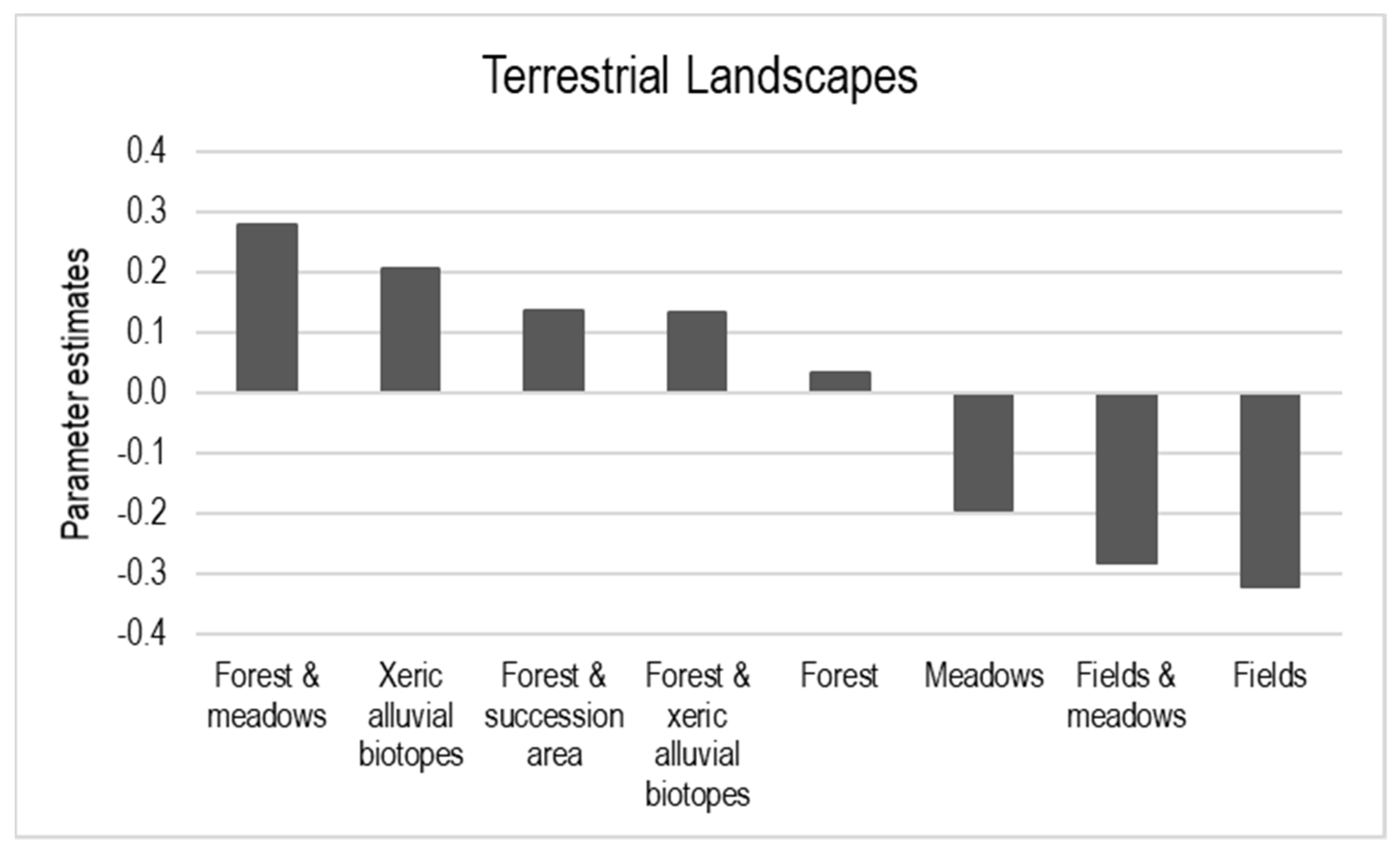
The combination of a meadow with a forest or xeric alluvial biotopes were the two most preferred levels of the terrestrial landscape attribute, followed by the combinations of forest with succession area and forest with xeric alluvial biotopes. In contrast, fields, the combination of a field with a meadow and meadows only were disliked (Table 3; Figure 5). Forest only was in between.
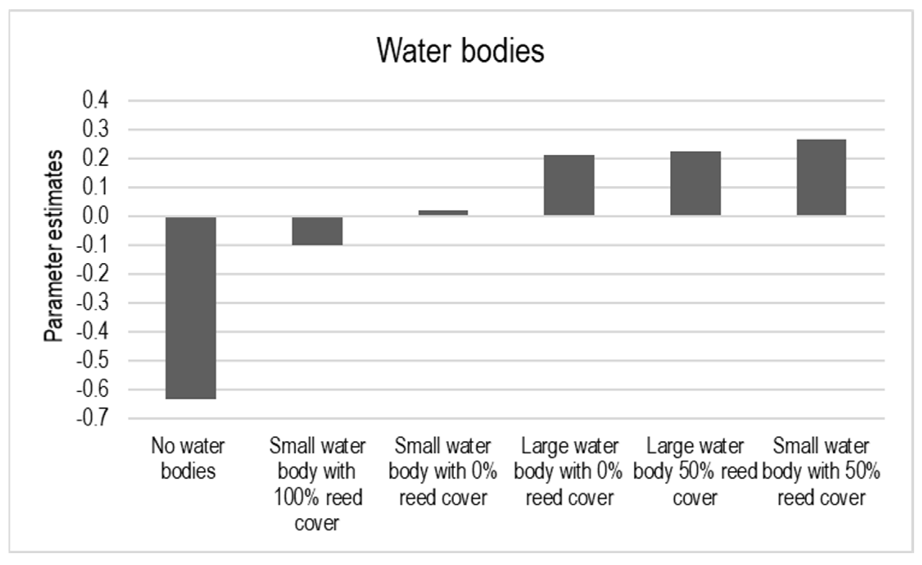
Trails that did not offer a view of water bodies were rated particularly negatively, followed by a small oxbow lake with 100% reed cover (Table 3; Figure 6). The respondents preferred both large and small oxbow lakes with 50% reed cover, as well as large oxbow lakes without reed cover.
Visitors preferred a nearby forest in the background with or without a power pole, but strongly disliked a settlement with a power pole. The evaluation of the forest 300 m away was in between (Table 3).
The presence of trail vegetation was preferred. Respondents preferred alleys of trees over a tree-lined path or a solitary tree. A narrow trail (0.8 m) was preferred to a broader trail. Trails of 4 m width were disliked. A natural trail, with or without puddles, was preferred to a gravel trail and, particularly, to an asphalt one (Table 3).
One person or four people on the trail were preferred, while higher numbers were disliked. In particular, groups of 16 people were strongly disliked. Scenarios with a 25% or 75% proportion of bicyclists were preferred to a 100% proportion of hikers and a 50% proportion of bicyclists. Visitors preferred the absence of dogs on the trail and specifically disliked one dog off a leash.
Respondents preferred a small restaurant with a beer garden or a natural swimming area with a sunbathing area, and disliked a large dog zone with seating opportunities and drinking water. A public transport stop in close distance was disliked (Table 3).
4. Discussion
This study aimed at understanding whether, and how, key visual characteristics of the Lobau area and its surroundings influence the landscape preferences of park visitors. An image-based choice survey questioned the influence of various landscape features (water bodies, alluvial forests, meadows, fields, settlement), recreational infrastructure facilities (trails, swimming areas…) and social trail use conditions (trail user numbers, visitor activities…) on the preferences for riverscapes of visitors to the protected area. The survey found that visitors’ preferences were influenced by many biophysical, infrastructural and social factors. The presence of water bodies increased the attractiveness of the area. Visitor numbers, terrestrial landscapes and water bodies were important for respondents’ choices, while recreational infrastructures, offerings and specific social attributes were not.
4.1. Landscape Preferences
The results of this study are in line with the landscape preference theories [8,9]. Visitors preferred semi-open landscapes, indicated by a matrix of forests with more open landscape types such as meadows, xeric alluvial biotopes and succession areas. Respondents disliked agriculturally dominated open landscapes consisting of meadows and/or fields. Openness is a key characteristic of the area surrounding the Lobau. However, people disliked this degree of openness, also indicated by their dislike of a forest at a greater distance. In addition, it was very important for participants to see natural areas instead of settlements.
Respondents highly preferred xeric alluvial biotopes, which are typical of the riverscapes of the Danube River. The areas are rare and valuable habitats for threatened species. People’s visual preferences for these habitats indicate an ecological aesthetic [43,47], suggesting that nature conservation efforts associated with that specific landscape element will receive their support.
The presence of water courses was one of the most important landscape features for making choices, and water courses were even more important than terrestrial landscape elements. People preferred water bodies, independent of their size and the amount of reed cover. Previous research found that water is one of the most favored elements in landscape preferences [5]. A small oxbow lake completely covered with reeds was less preferred compared to oxbow lakes with lower reed cover, likely because a 100% cover of reed blocks the view on the water and prevents swimming. Eder and Arnberger [4] also found heterogeneous preferences for reed along rivers among adolescents.
4.2. Preferences for Recreational Trails and Infrastructure Offers
Trails are the most important recreational infrastructures in natural areas, and national park management must make decisions on the type of recreational infrastructure that corresponds to the protected area’s policy and is appropriate for its visitors [48]. However, little research has been conducted regarding preferences for trail qualities of protected urban riverscapes. In addition, managers have scarce knowledge on which and how recreation opportunities, such as trails or other recreational infrastructures, should be provided.
Several studies have analyzed the trail preferences of visitors in rural and urban areas [15,16,17,18], and most have found a preference for more natural trails with a width of about 2 m or even wider. Whereas this study confirms the preference for more natural trails, it showed that respondents were in favor of a very narrow natural trail with puddles. Arnberger and Eder [15] explained the preference for broader trails with the high percentages of bicyclists in their urban sample. This study, however, included even more bicyclists. A recent preference study in a German national park also found that visitors liked a natural trail with puddles better [16]. It seems that visitors to natural areas such as national parks show a higher preference for narrower natural trails compared to visitors to more urban green spaces.
Whereas trail width and trail surface were not very important attributes for respondents’ choices, trail vegetation was a decisive feature. This study found a preference for trail vegetation, and this increased with the number of trees. This preference for trees has also been reported in several other studies [16,43,44].
A main task of riverscape managers in the urban context is the provision of suitable recreation infrastructures. The study respondents preferred natural swimming areas and a small restaurant. These offers exist in and near the park, and managers might pay greater attention to the swimming areas in the park compared to the dog zones.
4.3. Preferences for Social Conditions on Trails
In agreement with many studies on human preferences for visitor numbers in natural areas, this study found that visitor density affects preferences, and few visitors on the trail are preferred [15,19,20,21,22]. The attribute level with 16 visitors on the trail was the strongest predictor among all levels of the DCE. Social aspects play an important role for natural area visits. In particular, too many trail users can be a reason for recreationists not visiting an area or a trail because of exceeded social carrying capacities. One possible explanation for the high importance of visitor numbers in visitor choices might be the high use pressure. Many respondents reported that the number of visitors to the Lobau on Sundays was too high. Most studies using image-based DCEs in the fields of outdoor recreation and landscape preference stressed the important role of visitor numbers in respondents’ choices [4,15,16,18,23,24,44]. However, the findings are mixed. In some studies, visitor numbers were the strongest predictor in landscape choices [15,23,24], but not in others [4,16].
User conflicts between various activity groups—such as between walkers and bicyclists or between bicyclists or walkers and dog walkers—negatively impact the recreation experience [15,16,17,18,19,20,21,22,23,33,49,50,51,52]. Based on visitor evaluations, user composition did not play a strong role in choices. The same results have been found in previous image-based DCEs [15,16,44]. The very high proportion of bicyclists and walkers in the sample may explain the preferences for scenes with higher proportions of bicyclists or walkers. Similarly, dogs and dog walkers´ behavior did not play a major role for respondents’ choices. This study found that dogs are disliked, and the same results applied to a dog zone. It seems that social carrying capacity aspects, in terms of visitor numbers, are more important for respondents than user conflicts between walkers and bicyclists or between dog walkers and other area users.
Multiple-use trails in natural areas create to several management challenges due to frequent user conflicts. Implementing visitor management measures and strategies for reducing use pressure can, for example, address unwanted off-leash dog walking, as well as the implementation of additional green spaces to reduce visitor density. In addition, the human behavior of not keeping dogs on a leash increases the impact on wildlife [33,38].
5. Conclusions
This study investigated visitor preferences for riverscape attributes of the Lobau area and its directly surrounding landscape. The study found tradeoffs in visitor preferences between biophysical attributes, recreational infrastructures and social factors. Thus, specific features of the area can serve as potential substitutes for others of the area because of their similar parameter values.
The study results indicate that the current foreland is not very attractive for visitors, as most preferred water-based and terrestrial landscape elements and trail types that can be found in the national park, but not in the current open agrarian and settlement-dominated landscape of the foreland. This study provides information on visitors’ preferences and criteria for how to transform the Lobau foreland into a more attractive recreational area to deflect some recreational use pressure from the national park. The national park is being confronted with increasingly high-use levels, particularly because of the many new housing projects being developed near the protected area. The recreation use pressure is progressively fragmenting the area, thereby reducing further undisturbed zones and times for wildlife [21,33,38].
The Lobau foreland might be changed through different treatment designs to address visitors’ preferences. Narrow natural trails with alleys of trees, small-scale mixtures of meadows and forest patches, lakes with some reeds, and places to swim increase the attractiveness, while fields, missing water bodies, broad asphalt trails, settlements in the landscape background, crowded trails, a large dog zone, and public transport stops in close distance decrease the attractiveness. Although many of the natural landscape elements of the national park, such as xeric alluvial biotopes, cannot be created in the foreland, a patchy mixture of meadows and forest patches received high or even higher preference scores. Future research may include the river and riverbanks, as well as the impact of traffic noise in preference modeling. Previous research in the area has shown that residents and visitors have strong emotional bonds to the Lobau area [53,54,55]. Linking the emotional bonds of the residents to the riverscape in connection with riverscape preferences [5] is another future research field.
Supplementary Materials
The examples of choice sets are available online at https://www.mdpi.com/article/10.3390/w13162178/s1.
Author Contributions
Conceptualization, A.A. and R.E.; methodology, A.A. and R.E.; software, A.A.; formal analysis, A.A.; investigation, A.A. and R.E.; data curation, A.A.; writing—original draft preparation, A.A. and R.E.; writing—review and editing, T.H., S.P., U.N.-M.; visualization, A.A.; project administration, A.A.; funding acquisition, A.A., R.E., T.H., S.P. and U.N-M. All authors have read and agreed to the published version of the manuscript.
Funding
This research was funded by the Austrian Man and the Biosphere Program of the Austrian Academy of Sciences. The research project contract was signed on 14 April 2008.
Institutional Review Board Statement
All subjects in the study were anonymously labeled and agreed to participate in the study.
Informed consent statement: Informed consent was obtained from all subjects involved in the study. The study was conducted in accordance with the Declaration of Helsinki.
Data Availability Statement
Restrictions apply to the availability of these data.
Acknowledgments
We thank the Municipal Office of Forestry and Urban Agriculture and the National Park Administration (MA49) of Vienna and H. Preisel, B. Allex, K. Taczanowska, T. Reichhart, G. Stanzer, R. Deussner, K. Reiter, A. Illedits, I. Kempter, K. Zsak, and I. Wagner.
Conflicts of Interest
The authors declare no conflict of interest. The funders had no role in the design of the study; in the collection, analyses or interpretation of data; in the writing of the manuscript; or in the decision to publish the results.
References
- Hornung, L.K.; Podschun, S.A.; Pusch, M. Linking ecosystem services and measures in river and floodplain management. Ecosyst. People 2019, 15, 214–231. [Google Scholar] [CrossRef] [Green Version]
- Sanon, S.; Hein, T.; Douven, W.; Winkler, P. Quantifying ecosystem service trade-offs: The case of an urban floodplain in Vienna, Austria. J. Environ. Manag. 2012, 111, 159–172. [Google Scholar] [CrossRef] [PubMed]
- Tockner, K.; Stanford, J.A. Riverine flood plains: Present state and future trends. Environ. Conserv. 2002, 29, 308–330. [Google Scholar] [CrossRef] [Green Version]
- Eder, R.; Arnberger, A. How heterogeneous are adolescents’ preferences for natural and semi-natural riverscapes as recreational settings? Landsc. Res. 2016, 41, 555–568. [Google Scholar] [CrossRef]
- Garcia, X.; Benages-Albert, M.; Buchecker, M.; Vall-Casas, P. River rehabilitation: Preference factors and public participation implications. J. Environ. Plan. Manag. 2020, 63, 1528–1549. [Google Scholar] [CrossRef]
- Pflüger, Y.; Rackham, A.; Larned, S. The aesthetic value of river flows: An assessment of flow preferences for large and small rivers. Landsc. Urban. Plan. 2010, 95, 68–78. [Google Scholar] [CrossRef]
- Heerwagen, J.H.; Orians, G.H. Humans, habitats, and aesthetics. In The Biophilia Hypothesis; Kellert, S.R., Wilson, E.O., Eds.; Island Press: Washington, DC, USA, 1993; pp. 138–172. [Google Scholar]
- Falk, J.H.; Balling, J.D. Evolutionary influence on human landscape preference. Environ. Behav. 2010, 42, 479–493. [Google Scholar] [CrossRef]
- Junker, B.; Buchecker, M. Aesthetic preferences versus ecological objectives in river restorations. Landsc. Urban. Plan. 2008, 85, 141–154. [Google Scholar] [CrossRef]
- Stewart, W.; Larkin, K.; Orland, B.; Anderson, D. Boater preferences for beach characteristics downstream from Glen Canyon Dam, Arizona. J. Environ. Manag. 2003, 69, 201–211. [Google Scholar] [CrossRef]
- Chin, A.; Daniels, M.D.; Urban, M.A.; Piegay, H.; Gregory, K.J.; Bigler, W.; Wohl, E. Perceptions of wood in rivers and challenges for stream restoration in the United States. Environ. Manag. 2008, 41, 893–903. [Google Scholar] [CrossRef]
- Piégay, H.; Gregory, K.J.; Bondarev, V.; Chin, A.; Dalhstrom, N.; Elosegi, A.; Zawiejska, J. Public perception as a barrier to introducing wood in rivers for restoration purposes. Environ. Manag. 2005, 36, 665–674. [Google Scholar] [CrossRef]
- Vesterinen, J.; Pouta, E.; Huhtala, A.; Neuvonen, M. Impacts of changes in water quality on recreation behavior and benefits in Finland. J. Environ. Manag. 2010, 91, 984–994. [Google Scholar] [CrossRef]
- Wilson, M.I.; Robertson, L.D.; Daly, M.; Walton, S.A. Effects of visual cues on assessment on water qualities. J. Environ. Psychol. 1995, 15, 53–63. [Google Scholar] [CrossRef]
- Arnberger, A.; Eder, R. Are urban visitors’ general preferences for green-spaces similar to their preferences when seeking stress relief? Urban Urban Green 2015, 14, 872–882. [Google Scholar] [CrossRef]
- Arnberger, A.; Eder, R.; Allex, B.; Preisel, H.; Ebenberger, M.; Husslein, M. Trade-offs between wind energy, recreational, and bark-beetle impacts on visual preferences of national park visitors. Land Use Policy 2018, 76, 166–177. [Google Scholar] [CrossRef]
- von Janowsky, D.; Becker, G. Characteristics and needs of different user groups in the urban forest of Stuttgart. J. Nat. Conserv. 2003, 11, 251–259. [Google Scholar] [CrossRef]
- Van Riper, C.J.; Manning, R.E.; Monz, C.A.; Goonan, K.A. Tradeoffs among resource, social, and managerial conditions on mountain summits of the Northern Forest. Leis. Sci. 2011, 33, 228–249. [Google Scholar] [CrossRef]
- Shelby, B.; Heberlein, T.A. Carrying Capacity in Recreation Settings; Oregon State University Press: Corvallis, OR, USA, 1986. [Google Scholar]
- Arnberger, A.; Aikoh, T.; Eder, R.; Shoji, Y.; Mieno, T. How many people should be in the urban forest? A comparison of trail preferences of Vienna and Sapporo forest visitor segments. Urban Urban Green 2010, 9, 215–225. [Google Scholar] [CrossRef]
- Burns, R.C.; Arnberger, A.; von Ruschkowski, E. Social carrying capacity challenges in parks, forests, and protected areas: An examination of transatlantic methodologies and practices. Int. J. Sociol. 2010, 40, 30–50. [Google Scholar] [CrossRef]
- Manning, R.E. Studies in Outdoor Recreation—Search and Research for Satisfaction; Oregon State University Press: Corvallis, OR, USA, 1999. [Google Scholar]
- Kainzinger, S.; Arnberger, A.; Burns, R.C. Setting preferences of high and low use river recreationists: How different are they? Environ. Manag. 2016, 58, 767–779. [Google Scholar] [CrossRef] [PubMed] [Green Version]
- Kainzinger, S.; Arnberger, A.; Burns, R.C. Whitewater recreationists’ preferences for social, resource and managerial attributes in the Alpine Nature and Geopark Styrian Eisenwurzen. J. Prot. Mt. Areas Res. Manag. 2017, 9, 52–60. [Google Scholar] [CrossRef] [Green Version]
- Eder, R.; Arnberger, A. The influence of place attachment and experience use history on perceived depreciative visitor behavior and crowding in an urban national park. Environ. Manag. 2012, 50, 566–580. [Google Scholar] [CrossRef]
- Meyer, T. Ökologie Mitteleuropäischer Flussauen; Springer Spektrum: Heidelberg, Germany, 2017. [Google Scholar]
- Louviere, J.J.; Hensher, D.A.; Swait, J.D. Stated Choice Methods—Analysis and Application; University Press: Cambridge, UK, 2000. [Google Scholar]
- Hensher, D.A.; Rose, J.M.; Greene, W.H. Applied Choice Analysis: A Primer; Cambridge University Press: Cambridge, UK, 2005. [Google Scholar]
- McFadden, D. Conditional logit analysis of qualitative choice behaviour. In Frontiers in Econometrics; Zarembka, P., Ed.; Academic Press: New York, NY, USA, 1974; pp. 105–142. [Google Scholar]
- Hein, T.; Blaschke, A.P.; Haidvogl, G.; Hohensinner, S.; Kucera-Hirzinger, V.; Preiner, S.; Reiter, K.; Schuh, B.; Weigelhofer, G.; Zsuffa, I. Optimised management strategies for the Biosphere reserve Lobau, Austria—based on a multi criteria decision support system. Ecohydrol. Hydrobiol. 2006, 6, 25–36. [Google Scholar] [CrossRef]
- Preiner, S.; Bondar-Kunze, E.; Pitzl, B.; Weigelhofer, G.; Hein, T. Effect of Hydrological Connectivity on the Phosphorus Buffering Capacity of an Urban Floodplain. Front. Environ. Sci. 2020, 8, 147. [Google Scholar] [CrossRef]
- Baart, I.; Gschöpf, C.; Blaschke, A.P.; Preiner, S.; Hein, T. Prediction of potential macrophyte development in response to restoration measures in an urban riverine wetland. Aquat. Bot. 2010, 93, 153–162. [Google Scholar] [CrossRef]
- Sterl, P.; Brandenburg, C.; Arnberger, A. Visitors’ awareness and assessment of recreational disturbance of wildlife in the Donau-Auen National Park. J. Nat. Conserv. 2008, 16, 135–145. [Google Scholar] [CrossRef]
- Knoll, T.; Fauna des Nationalpark Donau-Auen. Infothek Donau-Auen. Available online: https://infothek.donauauen.at/fileadmin/Infothek/2_WissenschaftlPublikationen/22_Forschung_Monitoring_Berichte_Karten/Fauna_Gesamtartenliste_NPDA_nach_Organismengruppe_Stand_2021.pdf (accessed on 15 June 2021).
- Grillitsch, H.; Cabela, A. Reptilien. In Atlas zur Verbreitung und Ökologie der Amphibien und Reptilien in Österreich. Auswertung der Herpetofaunistischen Datenbank der Herpetologischen Sammlung des Naturhistorischen Museums in Wien; Cabela, A., Grillitsch, H., Tiedemann, F., Eds.; Umweltbundesamt: Wien, Germany, 2001; pp. 442–611. [Google Scholar]
- Frühauf, J.; Sabathy, E. Untersuchungen an Schilf- und Wasservögeln in der Unteren Lobau. Teil 2: Arten; Wissenschaftliche Reihe Nationalpark Donau-Auen: Orth/Donau, Austria, 2016; Volume 55, pp. 1–79. [Google Scholar]
- Schmidt, M. Populationsstatus des Eisvogels im Nationalpark Donau-Auen sowie eine Abschätzung der überregionalen Bestandsentwicklung; Wissenschaftliche Reihe Nationalpark Donau-Auen: Orth/Donau, Austria, 2016; Volume 51, pp. 1–32. [Google Scholar]
- Arnberger, A.; Frey-Roos, F.; Eder, R.; Muralt, G.; Nopp-Mayr, U.; Tomek, H.; Zohmann, M. Ökologische und soziale Tragfähigkeiten als Managementherausforderungen für suburbane Biosphärenparke am Beispiel Untere Lobau; Man & Biosphere-Programm der Österr. Akademie der Wissenschaften (ÖAW), 135, Österr. Akademie der Wissenschaften: Wien, Germany, 2009. [Google Scholar]
- Grillmayer, R.; Schacht, H.; Wöss, M.; Völk, F.; Hoffmann, C. Wildökologische Korridore; Project report; University of Natural Resources and Applied Life Sciences: Vienna, Austria, 2002. [Google Scholar]
- Suppan, F.; Frey-Roos, A. Generating Resistance Surfaces for Wildlife Corridor Extraction. J. Photogramm. Remote. Sens. Geoinf. Sci. 2014, 5, 435–450. [Google Scholar]
- Arnberger, A. Recreation use of urban forests: An inter-area comparison. Urban Urban Green 2006, 4, 135–144. [Google Scholar] [CrossRef]
- Kemperman, A.D.A.M.; Timmermans, H.J.P. Heterogeneity in urban park use of aging visitors: A latent class analysis. Leis. Sci. 2006, 28, 57–71. [Google Scholar] [CrossRef]
- Gobster, P.H.; Arnberger, A.; Schneider, I.E.; Floress, K.M.; Haines, A.L.; Dockry, M.J.; Benton, C. Restoring a “scenically challenged” landscape: Landowner preferences for pine barrens treatment practices. Landsc. Urban. Plan. 2021, 211, 104104. [Google Scholar] [CrossRef]
- Arnberger, A.; Eder, R. Exploring the heterogeneity of rural landscape preferences: An image-based latent class approach. Landsc. Res. 2011, 36, 19–40. [Google Scholar] [CrossRef]
- Shr, Y.-H.; Ready, R.; Orland, B.; Echols, S. How do visual representations influence survey responses? Evidence from a choice experiment on landscape attributes of green infrastructure. Ecol. Econ. 2019, 156, 375–386. [Google Scholar] [CrossRef]
- Vermunt, J.K.; Magidson, J. Technical Guide for Latent Gold Choice 4.0: Basic and Advanced; Statistical Innovations Inc.: Belmont, MA, USA, 2005. [Google Scholar]
- Gobster, P.H. An ecological aesthetic for forest landscape management. Landsc. J. 1999, 18, 54–64. [Google Scholar] [CrossRef]
- Moore, R.L.; Driver, B.L. Introduction to Outdoor Recreation. Providing and Managing Natural Resource-Based Opportunities; Venture: State College, PA, USA, 2005. [Google Scholar]
- Bakhtiari, F.; Jacobsen, J.B.; Jensen, F.S. Willingness to travel to avoid recreation conflicts in Danish forests. Urban Urban Green 2013, 13, 662–671. [Google Scholar] [CrossRef] [Green Version]
- Cessford, G. Perception and reality of conflict: Walkers and mountain bikes on the Queen Charlotte Track in New Zealand. J. Nat. Conserv. 2003, 11, 310–316. [Google Scholar] [CrossRef] [Green Version]
- Jacob, G.R.; Schreyer, R. Conflict in outdoor recreation: A theoretical perspective. J. Leis. Res. 1980, 12, 368–380. [Google Scholar] [CrossRef]
- Schneider, I.E.; Hammitt, W.E. Visitor responses to on-site recreation conflict. J. Appl. Recreat Res. 1995, 20, 249–268. [Google Scholar]
- Arnberger, A.; Eder, R. The influence of green space on community attachment of urban and suburban residents. Urban Urban Green 2012, 11, 41–49. [Google Scholar] [CrossRef]
- Verbrugge, L.; Buchecker, M.; Garcia, X.; Gottwald, S.; Müller, S.; Præstholm, S.; Olafsson, A.S. Integrating sense of place in planning and management of multifunctional river landscapes: Experiences from five European case studies. Sustain. Sci. 2019, 14, 669–680. [Google Scholar] [CrossRef] [Green Version]
- Wynveen, C.J.; Schneider, I.E.; Arnberger, A.; Cottrell, S.; von Ruschkowski, E. Integrating Place Attachment into Management Frameworks: Exploring Place Attachment Across the Recreation Opportunity Spectrum. Environ. Manag. 2020, 66, 248–262. [Google Scholar] [CrossRef]
Figure 1.
Location of the Danube Floodplains National Park in East Austria, the Viennese Lobau and the surrounding Lobau foreland. The foreland is dominated by agrarian areas and settlements (Photo: Arnberger).
Figure 1.
Location of the Danube Floodplains National Park in East Austria, the Viennese Lobau and the surrounding Lobau foreland. The foreland is dominated by agrarian areas and settlements (Photo: Arnberger).

Figure 2.
Base photo of a recreational trail in the Lobau used in the construction of the visual choice scenarios.
Figure 2.
Base photo of a recreational trail in the Lobau used in the construction of the visual choice scenarios.

Figure 3.
Example of a scenario consisting of 11 visual and pictogram assisted textual attributes with varying attribute levels used in the discrete choice experiment.
Figure 3.
Example of a scenario consisting of 11 visual and pictogram assisted textual attributes with varying attribute levels used in the discrete choice experiment.

Figure 4.
Example of a choice set. Each choice set was printed on A3 paper. Each respondent viewed 4 out of 64 choice sets and was asked to choose the most and least preferred scenario from each set.
Figure 4.
Example of a choice set. Each choice set was printed on A3 paper. Each respondent viewed 4 out of 64 choice sets and was asked to choose the most and least preferred scenario from each set.

Figure 5.
Preferences for terrestrial landscapes (n = 520).

Figure 6.
Preferences for water bodies (n = 520).


Table 1.
Eleven attributes and their levels and mode of presentation.
| Attribute | Attribute Levels | Presentation Mode |
|---|---|---|
| Terrestrial landscapes | 8 levels | Digitally calibrated image |
| Water bodies | 6 levels | Extra, partly digitally calibrated image |
| Landscape background | 4 levels | Digitally calibrated image |
| Trail vegetation | 4 levels | Digitally calibrated image |
| Trail surface | 4 levels | Digitally calibrated image |
| Trail width | 4 levels | Digitally calibrated image |
| Visitor numbers | 4 levels | Digitally calibrated image |
| Activity types | 4 levels | Digitally calibrated image |
| Dogs and dog walking behavior | 4 levels | Digitally calibrated image |
| Recreational infrastructure offers | 4 levels | Pictogram assisted text |
| Access/signage | 4 levels | Pictogram assisted text/digitally calibrated image |
Table 2.
Relative importance of the attributes for riverscape preferences based on the conditional logit model (n = 520).
Table 2.
Relative importance of the attributes for riverscape preferences based on the conditional logit model (n = 520).
| Attribute | Relative Importance |
|---|---|
| Visitor numbers | 20.5% |
| Horizon/landscape background | 16.5% |
| Water bodies | 14.8% |
| Trail vegetation | 13.1% |
| Terrestrial landscapes | 9.9% |
| Recreational infrastructure offers | 7.8% |
| Trail width | 4.9% |
| Trail surface | 4.1% |
| Dogs and dog walking behavior | 3.4% |
| Access/signage | 2.6% |
| Activity type | 2.5% |
Table 3.
Parameter estimates and standard errors for attribute levels of the DCE (n = 520).
| Attributes | Attribute Levels | Parameter Estimate | S.E. |
|---|---|---|---|
| Biophysical attributes (landscape and water bodies) | Terrestrial landscapes | ||
| Forest a | 0.036 | ||
| Meadows | ***−0.192 | 0.054 | |
| Xeric alluvial biotopes | ***0.206 | 0.051 | |
| Fields | ***−0.321 | 0.055 | |
| Field & meadow | ***−0.281 | 0.051 | |
| Forest & xeric alluvial biotopes | *0.135 | 0.053 | |
| Forest & meadow | ***0.279 | 0.054 | |
| Succession area & forest | *0.137 | 0.056 | |
| Water bodies | |||
| No water bodies a | −0.632 | ||
| Small water body with 0% reed cover | 0.022 | 0.048 | |
| Small water body with 50% reed cover | ***0.266 | 0.051 | |
| Large water body with 0% reed cover | ***0.215 | 0.052 | |
| Large water body 50% reed cover | ***0.226 | 0.050 | |
| Small water body with 100% reed cover | *−0.097 | 0.039 | |
| Trail vegetation | |||
| No trail vegetation a | −0.365 | ||
| Tree line | ***0.192 | 0.034 | |
| Alley of trees | ***0.435 | 0.036 | |
| Solitary tree | ***−0.262 | 0.034 | |
| Landscape background | |||
| Forest in close distance | 0.283 | ||
| Forest in in close distance with power pole | ***0.328 | 0.033 | |
| Forest in 300 m distance | (*)0.063 | 0.034 | |
| Settlement with power pole | ***−0.674 | 0.035 | |
| Social attributes describing trail use | Visitor numbers | ||
| 1 persona | 0.525 | ||
| 4 persons | ***0.240 | 0.034 | |
| 8 persons | −0.047 | 0.034 | |
| 16 persons | ***−0.719 | 0.035 | |
| Activity type | |||
| 100% walkers a | −0.034 | ||
| 75% walkers, 25% bicyclists | 0.056 | 0.035 | |
| 50% walkers, 50% bicyclists | **−0.088 | 0.035 | |
| 25% walkers, 75% bicyclists | (*)0.066 | 0.035 | |
| Dogs and dog walker behavior | |||
| No dog a | 0.113 | ||
| 2 dogs on leash | −0.032 | 0.034 | |
| 2 dogs off leash | 0.011 | 0.034 | |
| 1 dog off leash | **−0.091 | 0.033 | |
| Recreation infrastructures (trails, infrastructure offers, access & signage) | Trail width | ||
| 0.8 m a | 0.171 | ||
| 2 m | −0.026 | 0.033 | |
| 3 m | −0.018 | 0.033 | |
| 4 m | ***−0.126 | 0.034 | |
| Trail surface | |||
| Asphalt a | −0.135 | ||
| Gravel | −0.047 | 0.033 | |
| Natural | *0.067 | 0.033 | |
| Natural with puddles | ***0.115 | 0.034 | |
| Recreation facilities | |||
| No facilities a | −0.032 | ||
| Large dog zone with seating opportunities & drinking water | ***−0.278 | 0.034 | |
| Natural swimming area with sunbathing area (or wildlife enclosure) | ***0.193 | 0.033 | |
| Small restaurant with beer garden | ***0.118 | 0.033 | |
| Access & signage | |||
| Nothing a | 0.083 | ||
| Signpost | (*)−0.064 | 0.034 | |
| Parking lot accessible within 10 min walking distance | (*)0.057 | 0.030 | |
| Public transport stop accessible within 10 min walking distance | **−0.076 | 0.028 | |
| Pseudo-R2 | 160 |
a Reference category. Significant influence of the attribute levels on respondents’ choices: (*) p < 0.10; * p < 0.05; ** p < 0.01; *** p < 0.001.
Publisher’s Note: MDPI stays neutral with regard to jurisdictional claims in published maps and institutional affiliations. |
© 2021 by the authors. Licensee MDPI, Basel, Switzerland. This article is an open access article distributed under the terms and conditions of the Creative Commons Attribution (CC BY) license (https://creativecommons.org/licenses/by/4.0/).
Share and Cite
MDPI and ACS Style
Arnberger, A.; Eder, R.; Preiner, S.; Hein, T.; Nopp-Mayr, U. Landscape Preferences of Visitors to the Danube Floodplains National Park, Vienna. Water 2021, 13, 2178. https://doi.org/10.3390/w13162178
AMA Style
Arnberger A, Eder R, Preiner S, Hein T, Nopp-Mayr U. Landscape Preferences of Visitors to the Danube Floodplains National Park, Vienna. Water. 2021; 13(16):2178. https://doi.org/10.3390/w13162178
Chicago/Turabian StyleArnberger, Arne, Renate Eder, Stefan Preiner, Thomas Hein, and Ursula Nopp-Mayr. 2021. "Landscape Preferences of Visitors to the Danube Floodplains National Park, Vienna" Water 13, no. 16: 2178. https://doi.org/10.3390/w13162178
Note that from the first issue of 2016, this journal uses article numbers instead of page numbers. See further details here.