
Pasts and Presents of Urban Socio-Hydrogeology: Groundwater Levels in Berlin, 1870–2020

Integrative Research Institute on Transformations of Human-Environment Systems (IRI THESys), Humboldt-Universitaet zu Berlin, 10099 Berlin, Germany
*
Author to whom correspondence should be addressed.
Water 2021, 13(16), 2261; https://doi.org/10.3390/w13162261
Submission received: 1 July 2021
/
Revised: 9 August 2021
/
Accepted: 11 August 2021
/
Published: 19 August 2021
(This article belongs to the Special Issue Socio-Hydrogeology in Groundwater Resources Assessments and Management)
Abstract
:Although it is self-evident that today’s groundwater issues have a history that frames both problems and responses, these histories have received scant attention in the socio-hydrogeological literature to date. This paper aims to enrich the field of socio-hydrogeology with a novel, historical perspective on groundwater management whilst simultaneously demonstrating the value to water history of engaging with groundwater. This is achieved by applying hydrogeological, socio-hydrogeological, and historical methods in an interdisciplinary and collaborative research process while analysing a case study of urban groundwater management over a 150-year period. In the German capital Berlin, local aquifers have always been central to its water supply and, being close to the surface, have made for intricate interactions between urban development and groundwater levels. The paper describes oscillations in groundwater levels across Berlin’s turbulent history and the meanings attached to them. It demonstrates the value to socio-hydrogeology of viewing the history of groundwater through a socio-material lens and to urban history of paying greater attention to subsurface water resources. The invisibility and inscrutability associated with groundwater should not discourage attention, but rather incite curiosity into this underexplored realm of the subterranean city, inspiring scholars and practitioners well beyond the confines of hydrogeology.
1. Introduction
As the emergent field of socio-hydrogeology gains traction within the water research community, considerable work is being dedicated to defining its disciplinary contours, thematic range, and practical value. Pioneering studies on the interaction of groundwater and society address applications of a structured interdisciplinary approach [1], health issues [2,3], groundwater governance [4], participatory approaches [5,6], and the link to geo-ethics including effective outreach strategies [7]. This body of scholarship has already mapped out an impressive terrain for socio-hydrogeology but is distinctive for focusing almost exclusively on current challenges of groundwater assessment and management. It is thus a very ‘presentist’ take on socio-hydrogeology that is being advocated. Although it is self-evident that today’s groundwater issues have a history that frames both problems and responses, these histories have received scant attention in the literature. This criticism can be levelled not only at socio-hydrogeologists. It also applies to a surprising extent to water historians. Their concern has, to a large degree, been focused on the water resources visible and accessible above ground. We know little, in particular, about the social and political dimensions to the history of groundwater. On both fronts—socio-hydrogeology and water history—there exists a serious knowledge gap.
This paper aims to enrich the field of socio-hydrogeology with a novel, historical perspective on groundwater assessment and management whilst simultaneously demonstrating the value to water history of engaging with groundwater as a socio-material configuration. The core objective is to show how the field of socio-hydrogeology could benefit from extending its concern for temporal dynamics to consider histories of groundwater politics, debates, and patterns of use. The paper reveals past social dimensions to hydrogeology not only from the vantage point of historical analysis today, but also through the eyes of past hydrogeologists. This makes the findings particularly relevant for modern-day managers of groundwater resources.
In line with the exploratory nature of this venture, the chosen method of analysis is a case study of Berlin’s urban groundwater management covering a period of 150 years. Berlin’s hydrogeology is shaped by the Quaternary glacial periods. The low-lying Warsaw–Berlin glacial valley, which is mainly composed of sandy and gravelly deposits, is flanked by plateaus in the north and in the south, which are to a large extent covered with thick boulder clay and glacial till of the ground moraines. The average 150 m thick Quaternary and Tertiary unconsolidated sediments form the freshwater reservoir and can be divided into four aquifers. The second, predominantly Saale-age aquifer, is referred to as the main aquifer, since it is the principal source of water supplied to the city [8].
The city of Berlin lends itself admirably as a case study for several reasons. First, the local aquifers described above have always been central to Berlin’s water supply. Today, all of its drinking water stems from groundwater sources in and around the city that are replenished by passing surface water, precipitation, and infiltration ponds. Second, the water table is, in many locations, very close to the surface, making for intricate interactions between urban development and groundwater levels. Third, the city has monitored groundwater levels, for this reason, continuously since 1869, providing rare documentation over a long period of time. Fourth, urban development in Berlin has been highly volatile since the early twentieth century, pitted by frequent socio-economic and political crises (e.g., hyper-inflation, depression, war, division, and reunification) that have impacted significantly upon levels of water use and, consequently, groundwater abstraction. All these factors make Berlin ideally suited to a long-term analysis of the complex and dynamic relationship between urban development, water use, and groundwater levels in a city. Our focus on groundwater levels does not deny the importance of groundwater quality to the city. However, this will not be discussed here, to allow full attention to be paid to the complex issue of interactions between the city and groundwater levels.
The fact that Berlin today is still struggling to cope with volatile groundwater levels in parts of the city emphasises the practical importance of developing a finer understanding of the history of urban socio-hydrogeology. This is reflected in the interdisciplinary collaboration underpinning the paper, which has been researched and written by a socio-hydrogeologist and a historian of urban infrastructures. We have drawn on our own literatures—on hydrogeology and water history, respectively—and applied our specific research methods, interpreting groundwater records and interviewing hydrogeologists (two semi-structured expert interviews) on the one hand and analysing historical documents on the other. By combining these different sources of knowledge, we developed a cross-disciplinary approach capable of unpacking the socio-material configurations and temporal dynamics so critical to understanding urban groundwater management.
The paper begins with literature reviews on the treatment of the past in (socio-) hydrogeology and of groundwater in (urban) water history, culminating in an analytical framework to guide the research. An empirical section then presents the Berlin case, tracing a 150-year relationship between the city and groundwater up to the present day. The subsequent interpretative section discusses the implications of the findings for research and practice on socio-hydrogeology. The conclusions summarise the principal arguments and plot a trajectory for future research.
2. Connecting Pasts and Presents of Socio-Hydrogeology
2.1. (Socio-) Hydrogeology and Its Treatment of the Past
Historical analysis has not been common in socio-hydrogeological research. Even though the very first paper introducing socio-hydrogeology [1] argues that incorporating the knowledge of local stakeholders can help to depict, understand, and use the historical context of a given study region, this is not applied in the case study there, nor in most of the literature published since. A few papers begin by mentioning the importance of history [4,9], but this is not pursued in their analysis. Only one paper explicitly takes a historical perspective by describing and analysing past natural and social conditions that have led to the current groundwater situation [10]. Di Pelino et al. [2] lament the absence of history in socio-hydrogeology and advocate a so-called eco-health approach, which would include historical context. However, the authors do not elaborate on how this might be applied.
Looking beyond the limited literature on socio-hydrogeology to hydrogeology in general, the picture is little better. Based on a literature review of papers written by hydrogeologists or related natural scientists or published in a hydrogeological or hydrological journal, it appears that the treatment of history is highly selective. Most hydrogeological publications dealing with the past relate either to the impact of earlier over-abstractions on current groundwater regimes or to long-term contamination of groundwater (e.g., [11,12]). However, the focus here is purely on environmental parameters. A much smaller but more relevant body of literature situates historical hydrogeological topics within a given socio-political, economic, or legal context, often drawing conclusions for the future based on the analysis of the past [13,14,15,16,17,18,19]. Robertson [16] (p. 356), for example, analyses historical debates from 1910 onwards around groundwater governance in Australia’s Great Artesian Basin and concludes that “if there is going to be real seriousness about sustainable management of the GAB [Great Artesian Basin], what is needed is to learn from the history of its management, […] and work to build a relationship between the regulator and the regulated, which empowers all groundwater users.”
Many publications deal with the history of the discipline of hydrogeology itself. Topics range from profiles of eminent hydrogeologists [20,21], the development of hydrogeology as a science [22,23,24,25,26], and the establishment of hydrogeological associations [27] to country-specific histories [28,29,30,31,32,33]. Even if some of these publications recognise the influence of context on the progress of hydrogeology (e.g., [30]), they are largely descriptive, seeing history as a linear trajectory of scientific progress. This also applies to the country studies included in the IAH edited volume “History of Hydrogeology” [34], which reads like a series of success stories with little critical reflection on how and why this ‘progress’ was possible. It talks, for instance, of Africa as “the other training and playground for French hydrogeologists” (ibid., p. 75) and overlooks uncomfortable periods such as the World Wars in the chapter on Germany (ibid., pp. 102–109).
An exception to these largely descriptive and selective histories of hydrogeology is Narasimhan’s [35] publication on hydrogeology in North America. In the sub-chapter “Groundwater and Society”, for example, the author analyses how in the past, present, and future, water has always been and will always be contested between those who want to control it and those who depend upon it. By drawing on the past, he is able to highlight the potential role hydrogeology can have in any future judicious management of finite groundwater resources by demonstrating the close relationship and mutual dependencies between hydrogeology and society. A publication by Stephens and Ankeny [36] further questions the linear narrative of the history of hydrogeology by showing that there have been individual non-scientists who independently developed significant hydrogeological knowledge.
A final group of publications was identified that explicitly uses historical documents, either exclusively [37,38,39] or in addition to hydrogeological methods [40,41]. In doing so, the authors generate new insights that can question previous findings based only on hydrogeological sources. For example, in their work about the salinity processes in an Australian aquifer, Dahlhaus et al. [41] (p. 1283) argue that “[by] using multiple lines of evidence from non-hydrogeologic sources such as geomorphic, archaeological and historical records […] the validity of the assumptions about salinity processes in Australian landscapes is challenged.” Similar to this approach, it is common for hydrogeologists beyond academia to analyse historical documents, maps, and photographs when working at contaminated sites [42].
Even though a critical and holistic historical perspective is not common in (socio-) hydrogeological research, the literature review offers some promising ideas for our analytical framework. These relate primarily to how past groundwater use, (mis)understandings of groundwater, and (lack of) regulation continue to shape present-day practices (e.g., [43]). Interestingly, several authors have an urban focus to their work, depicting the relationship between the development of cities and their groundwater resources (e.g., [18]).
2.2. Urban Water History and Its Treatment of Groundwater
Turning to the second dimension of relevant research—on groundwater in histories of water resources and cities—we can attest a similar degree of sporadic and superficial attention. The literature on urban water history is rich on rivers and cityscapes, urban water supply, water-based pollution, and sanitation systems, but largely silent on urban groundwater. Pioneering books on the socio-natures of water have changed the way we understand the interaction between a city, its surface water, and water infrastructures, but groundwater is mentioned—if at all—only in passing [44,45,46,47,48,49,50,51]. One possible explanation relates to the invisibility of groundwater: the problems emanating from its overuse or contamination are generally less tangible than in the case of river or lake water. There is often a temporal lapse between intervention and effect [52]. A second explanation is that the use of groundwater sources for urban water supply has, in many cities, been replaced by externally sourced piped water and is thereby associated with the pre-modern era (e.g., [53]). As Foster et al. [54] emphasise, however, groundwater use is still very prevalent in cities of the Global South, where there is evidence of past practices being reactivated in the present.
An online search of peer-reviewed journals publishing on water history revealed only a tiny number of papers that foreground the history of groundwater in general, let alone in cities. Many papers on groundwater refer only obliquely to ‘long histories’ of groundwater exploitation or pollution, assuming these to be self-explanatory (e.g., [55]). The few dedicated to groundwater history provide a fascinating, but very incomplete, impression of the issues at stake. These relate to the history of groundwater contamination from wastewater seepage and industrial pollution [56,57], the institutional legacy of past groundwater development in England [58], the history of excessive groundwater pumping in the USA [59], the origins of groundwater rights and regulation in California [60], and the role of groundwater in the history of Vienna [61]. All these contributions are largely descriptive and—with the exception of Haidvogl et al. [61]—lack conceptual framing.
Whilst the limited literature on groundwater history provides some important markers for empirical analysis, conceptual inspiration must be sought elsewhere. The ‘material turn’ within the social sciences and humanities has generated a powerfully relational understanding of socio-materiality. This work is directing attention toward the myriad ways in which social and material worlds shape each other, rather than exist as distinct entities. Urban historians are using this insight to highlight ways of “rematerializing cities”, exploring materiality as a formative factor of past power relations [62]. Human geographers are talking of the need to see ‘things’ not as pre-given artefacts that enable or constrain social action, but as “historical products of material, representational and symbolic practices” [63] (p. 18). The ‘material turn’ is reflected in water research informed by urban political ecology and social-ecological studies that highlight sociotechnical hybrids [64], techno-natures [51], socio-hydrology [65,66], and socio-natural interactions [61,67].
One focus of attention has been on water experts as curators of knowledge. This body of scholarship explores the discursive and political work of water engineers, hydrologists, and—by inference—hydrogeologists. It highlights the multiple roles enacted by water experts in history. They are shown to have operated as mediating agents of environmental and institutional transformation [68], agenda-setters of the hydrological cycle [69], political negotiators [70], and even historians themselves. “The ability to integrate disparate lines of inquiry into a narrative history,” Reuss [70] (p. 538) remarks, “thus becomes another useful analytical skill for engineers”. Exploring how hydrogeologists interpreted and construed past data on groundwater levels and urban water use is particularly pertinent to our historical analysis of the Berlin case.
2.3. A Framework for Analysing Pasts and Presents of Socio-Hydrogeology
Looking across the diverse literatures reviewed above, we identified from them three categories that address issues fundamental to our paper. These categories, devised from our literature review, are: (1) temporalities of groundwater; (2) histories of co-constitution between a city and its groundwater; and (3) historical knowledge about groundwater. Following common practice in the social sciences, these categories are developed not only to capture the state-of-the-art in relevant scholarship, but also—significantly—to guide our later interpretation of the Berlin case study, functioning thus as an original analytical framework (see Section 4) with the potential to inspire future research on similar topics.
2.3.1. Socio-Material Temporalities of Groundwater
These temporal dimensions refer, first, to long-term legacies of groundwater use. These can be environmental (e.g., because of past contamination), institutional (e.g., long-standing groundwater rights), socio-economic (e.g., industrial heritage), or infrastructural (e.g., the path dependence of a combined sewer system). Second, temporality is significant for groundwater monitoring, which relies on past measurements of water tables to assess risks for urban development and water supply and to develop reliable future scenarios. Third, mismatches of temporal scale, for instance between short-term extraction and long-term replenishment of groundwater resources, are a characteristic challenge confronting groundwater management.
2.3.2. Histories of Co-Constitution between a City and Its Groundwater
Groundwater and cities co-evolve in numerous ways. Most obviously, groundwater has enabled or constrained urban development in the past. Conversely, shifting urban contexts—whether political, socio-economic, or cultural—can shape groundwater use, resulting in over-abstraction or contamination. The literature on the socio-materiality of water directs attention to the dynamic and selective relationship between water underground and urban structures on the surface. Here, the distinctiveness of groundwater, especially vis-à-vis surface water, is particularly significant in terms of its invisibility and inscrutability.
2.3.3. Historical Knowledge about Groundwater
The history of hydrogeology itself raises a third set of issues worthy of attention. The development of urban hydrogeology as an applied science can reveal the motives and methods of monitoring and mapping groundwater. It also highlights the role of hydrogeologists as curators of this knowledge, in particular how they made sense of groundwater data and what narratives of a city’s socio-material history they told. Finally, it is important to note that past knowledge about groundwater can be forgotten or overlooked. Exploring how and why groundwater pasts have been disregarded or selectively remembered by which actors is key to our endeavour.
3. The Berlin Case: Tracing a 150-Year Relationship between City and Groundwater
3.1. Monitoring Groundwater Depletion as a Consequence of Urbanisation, 1870–1920
Berlin has always had an intimate, yet ambivalent, relationship with the water beneath its surface. Several historical place names such as Moderloch (Mildew Hollow), Gänsepfuhl (Goose Puddle), or Torffenne (Peat Fen) are testimony to the marshland existence of its early inhabitants [71] (p. 3). In the glacial valley (Berliner Urstromtal) running across today’s city centre, the groundwater table was a mere two to six metres below the surface around the turn of the last century [72] (p. 41). This had significant benefits, primarily for drinking water supplies. Plentiful groundwater could be accessed readily with shallow household wells [73]. Far into the twentieth century it was widely held—erroneously—that Berlin possessed virtually inexhaustible supplies of groundwater [74] (p. 413).
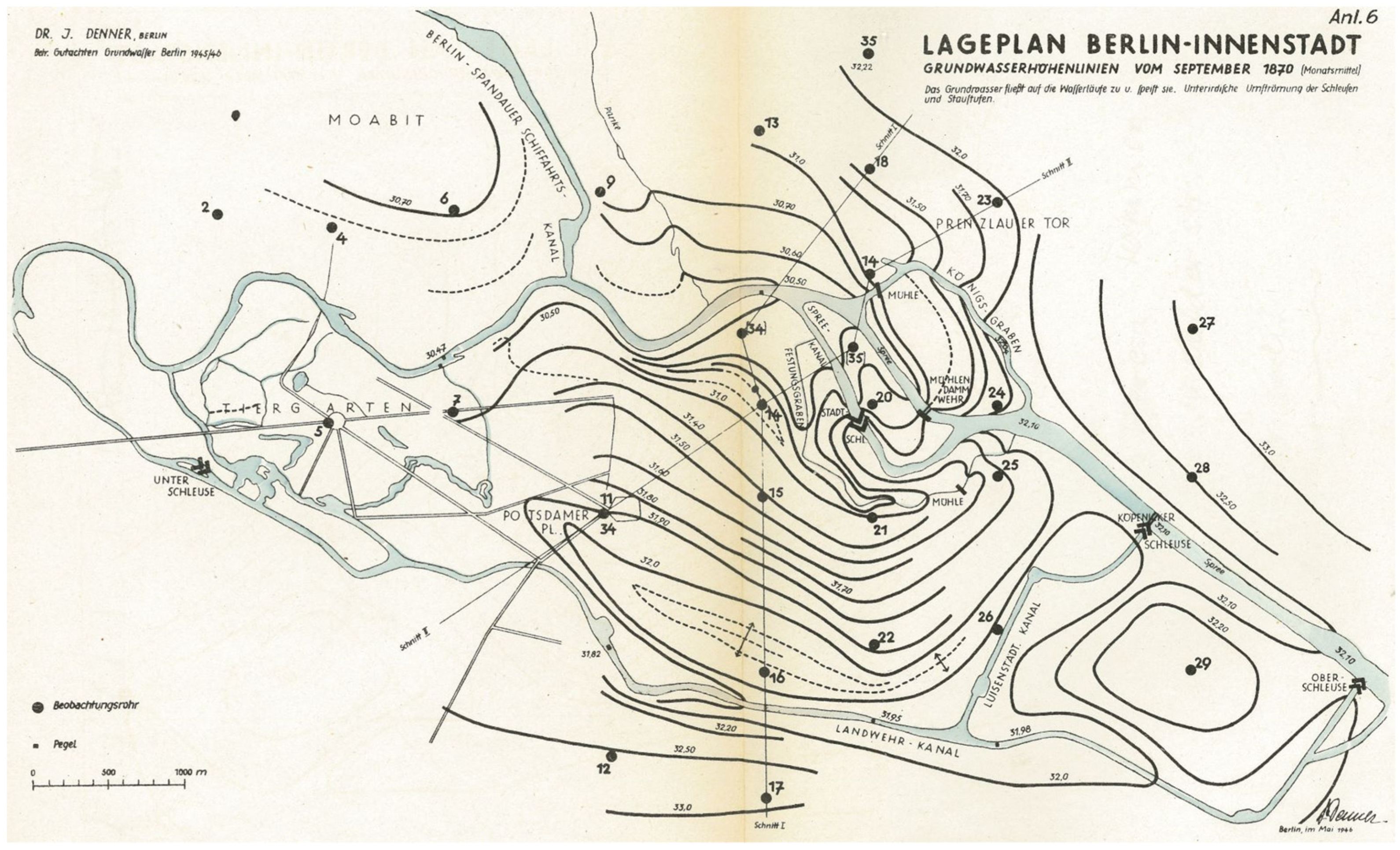
However, high groundwater levels brought with them problems of damp living conditions, recurrent flooding, and contaminated sources of drinking water. In the nineteenth century, as the city grew, so too did the public health risks of living in such close proximity with underground water. It was, indeed, medical experts who first drew attention to problems related to the city’s groundwater levels [71]. They pointed to water-borne epidemics, notably of typhoid fever, as products of groundwater contamination and chronically damp housing. The pathologist Rudolf Virchow initiated the first scientific observations of groundwater levels in the city in the mid-1860s at the same time as he was designing, together with the city planner James Hobrecht, its radically new sewer system [71] (p. 1). In 1869, Hobrecht established a network of 29 groundwater monitoring wells in Berlin as the first of its kind (Figure 1). In the eyes of these leading municipal figures, removing sewage and controlling groundwater were key components in the campaign to improve public hygiene.
Berlin’s groundwater monitoring network was extended over the following decades. By 1938, it comprised some 2000 observation wells spread across the (enlarged) city that were operated by a variety of public bodies including the water/wastewater utilities, waterways authority, and water research office, with data collated centrally by the city’s water management unit [72]. It is extraordinary to reflect that data on Berlin’s groundwater levels have been collected several times a week continuously since 1870, with only a brief interruption at the end of the Second World War, between April and June 1945 [73]. The longevity of this monitoring system can be explained by shifting concerns about groundwater levels. Once the construction of the sewer system and other ways of managing urban water flows had reduced the risk of water-borne diseases significantly by the early twentieth century, the chief problem was no longer groundwater levels being too high, but of them becoming too low [71].
In the early decades of the twentieth century, processes of urbanisation and industrialisation had a massive impact on Berlin’s groundwater levels. Waterworks were extracting a huge amount of water from the city’s aquifers, wastewater was being pumped out of the city to surrounding sewage farms whilst the sealed surfaces of streets, pavements, and roofs were preventing natural groundwater recharge with rainwater [71] (pp. 3–4), [72] (pp. 41–43), [76]. In addition to these long-term, structural interventions to the city’s hydrological cycle, short-term construction projects had major localised impacts on the city’s groundwater resources. The relatively high groundwater table in many parts of the city made it necessary, when building deep structures required for underground lines, sewers, and tall buildings, to pump water continuously out of building sites. The effect of this was to lower groundwater levels by as much as 15 metres in some parts of the city [77] (p. 180) such as at Alexanderplatz, Potsdamer Platz, and Gesundbrunnen [72] (p. 41).
The negative impacts of declining groundwater levels were serious and wide-ranging. First, several water wells in the city centre ran dry, threatening not only local drinking water supply, but also the capacity to fight fires [71] (p. 8), [72] (p. 41). Second, many buildings in the city centre suffered structural damage. This particularly applied to those built on foundations made of wooden stakes. Once these stakes were no longer submerged in groundwater, they began to rot, requiring costly repair work or demolition [78]. Prominent buildings that were saved thanks to extensive foundational repairs included the Imperial Palace before the First World War and the Imperial Library in the 1920s [72] (p. 41), [78] (p. 237). Other buildings suffered from land subsidence because of falling groundwater levels such as the New Museum, where frescos cracked under the shifting pressures from below [72] (p. 41). Third, the environmental impact of declining groundwater levels was severe, particularly in the vicinity of waterworks with high abstraction rates. The most prominent casualties were the lakes in the Grunewald. Their water levels dropped so sharply that they had to be artificially replenished with water pumped from the nearby River Havel—to the tune of 7.8 million m3 between 1913 and 1916 [71] (p. 2). In the city’s parks, it was reported that trees were suffering from a lack of water if located close to the wells serving major waterworks such as at Wuhlheide [72] (p. 41).
Since the municipal authorities and water utilities were unwilling to curb demand for water, they left themselves with little alternative but to shore up existing groundwater resources. Familiar with the interdependency between surface water and groundwater in the region, they explored methods of recharging groundwater to offset over-exploitation, at least in part. By the 1920s, all the city’s larger waterworks were operating some form of artificial groundwater recharge, whether bank filtration from neighbouring rivers or percolation of river water in special filtration beds [74] (p. 413). Julius Denner, the city’s most prominent hydrogeologist, argued that groundwater recharge should be extended beyond the needs of water supply to cover the wider urban environment, re-creating water-based landscapes dried out during urbanisation [74] (pp. 414, 466).
3.2. Observing and Explaining Groundwater Fluctuations as an Indicator of Urban Change, 1920–1950
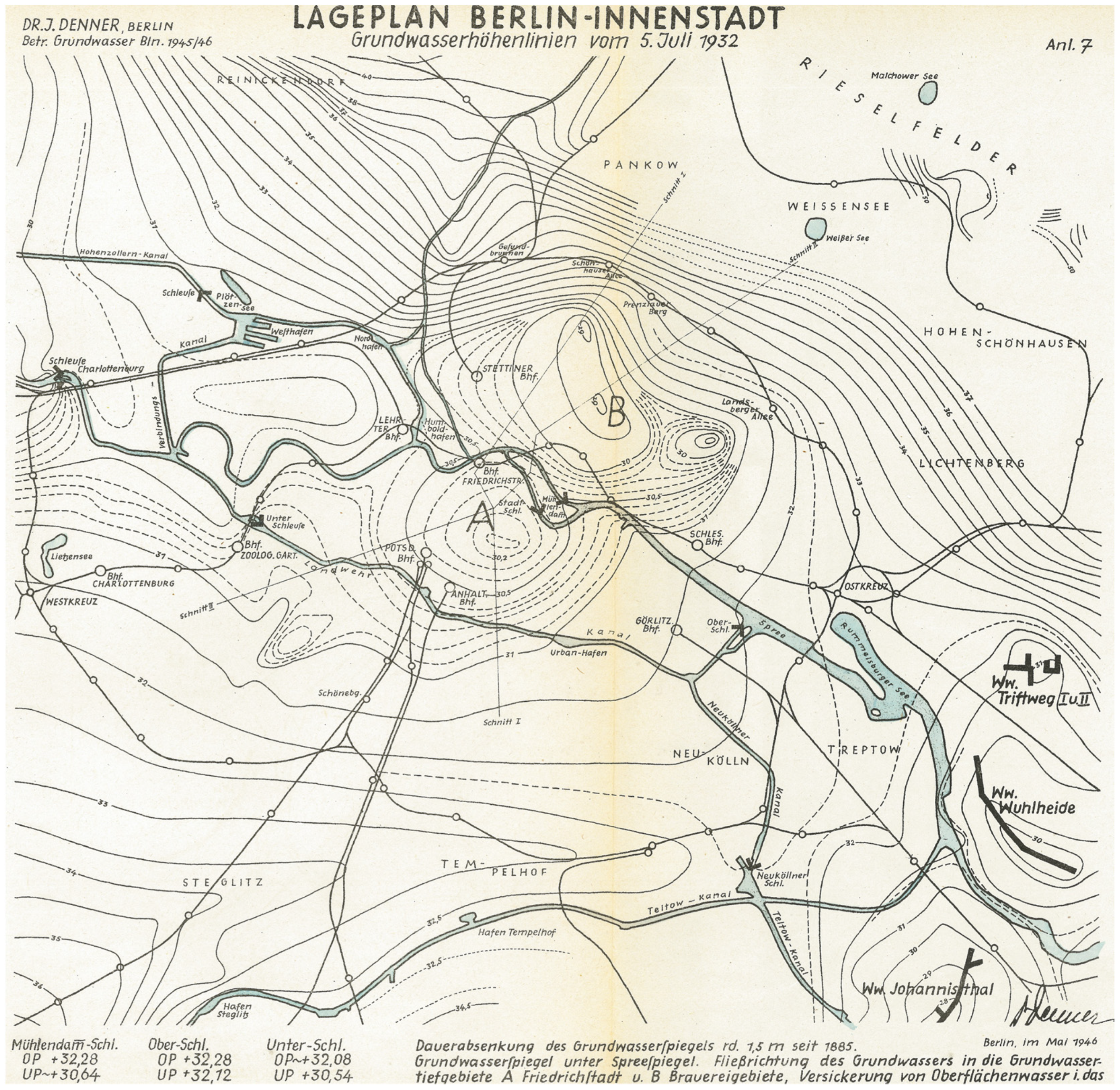
What the monitoring of Berlin’s groundwater levels revealed, over a long period, was that the steady downward path characteristic of the imperial era (1871–1918) became more fluctuating and accentuated in the interwar period [76]. Although groundwater levels continued to decline between 1920 and the Second World War (Figure 2), this overall trend hid some significant deviations from the norm, in both directions. It was Denner himself who recognised, with the benefit of hindsight, that there was a close correlation between groundwater levels and the economic performance of the city [73]. When Berlin was suffering from economic disruption or decline—as during the hyperinflation of 1920–1923 or during the Depression of 1929–1933—industrial production dropped, building work slowed down and, as a result, groundwater levels recovered. At times of economic growth, between 1924 and 1929 and again between 1934 and 1938, interventions in the city’s groundwater resources intensified and levels dropped once again. Figure 3 presents a simplified graph designed by contemporaries to illustrate this volatility.
Hydrogeologists were adamant that this fluctuation in groundwater levels could not be attributed to variations in annual precipitation [71,73]. Human interventions were the driving forces. In the late 1920s, it was the construction of underground transit lines that was highlighted for criticism [76] (p. 115). In the 1930s, it was the unregulated operation of private wells by factories, hotels, and department stores. The Berlin water utility blamed groundwater abstractions by these self-suppliers, estimated at 40–50 million m3 of water in 1933, for structural damage caused to many buildings in the city centre (Landesarchiv Berlin A Rep. 015, No. 143; Landesarchiv Berlin A Rep. 255, No. 131). Denner put the figure for 1938 even higher, at ca. 70 million m3, in addition to some 50 million m3 pumped out of construction sites [73] (p. 62).
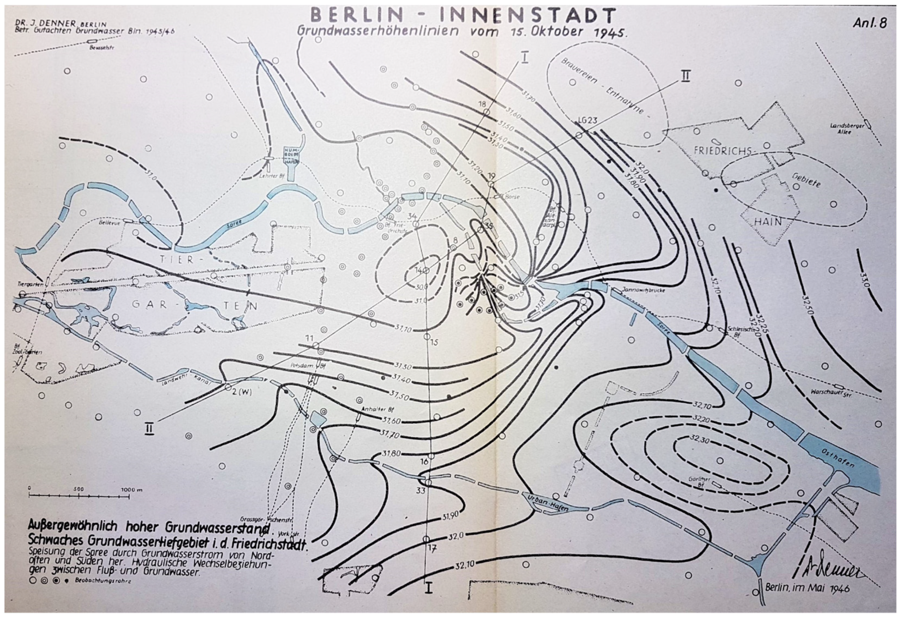
As the graph in Figure 3 also reveals, the war had a massive impact on groundwater levels in the reverse direction. Between 1940 and 1946, we can see groundwater levels once again rising, but this time more dramatically than during earlier crises [73] (p. 62). By 1945, Berlin was experiencing groundwater levels that had not been known since the 1880s. Several factors contributed to this striking phenomenon. Construction in the city had been severely restricted at the outbreak of hostilities and ground to a standstill as the war progressed. Consequently, rising groundwater did not need to be pumped out of building sites [77]. The abstraction of groundwater from private wells operated by hotels, shops, and factories fell sharply due to a drop in demand and bombing damage. Aerial bombardment also broke up sealed surfaces and made them more permeable to rainwater. The destruction of infrastructure for water supply and wastewater disposal increased water leakage temporarily. Groundwater levels also rose as a result of the River Spree being blocked by destroyed bridges, causing sharply increased bank filtration [79] (p. 34). In addition, the demand for water from the public utility by both households and industry dropped significantly as people and production relocated beyond the city to avoid the bombing raids. When one of the utility’s waterworks in Lichtenberg was closed in response to this drop in demand and bombing damage, groundwater levels rose by over 2.5 metres in a radius of up to 2.5 kilometres [73] (p. 62). This is all documented in a report on groundwater levels commissioned by the city government immediately after the war that was compiled by Denner [75]. Figure 4 maps the levels identified in October 1945, marking a stark contrast to those from earlier years.
The city government was keen to assess the situation because of the severe problems that rising groundwater was causing. Damp and flooding of low-lying cellars were, in Denner’s words, “a familiar phenomenon in the city centre” [73] (p. 64). Septic tanks were overflowing in the worst affected outlying areas such as Biesdorf-Süd, Kaulsdorf-Süd, and Mahlsdorf-Süd [77] (p. 181). Horticultural land was flooding from below, causing fruit trees to die: a major concern in the hunger-stricken city. What the experience revealed was that building in Berlin had, over the previous decades, relied on groundwater levels remaining as low as they had become following urbanisation. The planning and building community had not reckoned with a situation where groundwater could rise to anywhere near its nineteenth-century levels. This was, intriguingly, recognised by experts at the time. One building surveyor wrote scathingly in 1948:
“The damage today that is not only unpleasant but also the source of serious concern and great suffering could have been avoided if every building and development plan had been based on the highest natural groundwater levels rather than, as was often the case, the levels prevalent at the time of building” [77] (p. 181).
In the short-term, little could be done to alleviate the resulting problems. Artificially lowering groundwater levels was technically feasible, but uneconomic. Berlin’s municipal water utility, Berliner Wasserwerke, steadfastly refused to extract more groundwater from the worst affected areas simply to reduce localised flooding [77] (p. 181). Pumping rising groundwater out of cellars was far too expensive because it needed to be done continuously. Stop-gap solutions included raising the floor level of cellars with rows of bricks and reactivating disused open drains, still existent in some outlying areas, to redirect water away [77] (p. 181).
The long-term solution, as Denner argued at the time, was to wait until economic recovery would cause groundwater levels to fall once again [73]. Pointing to his analysis of groundwater data in Berlin spanning the previous 75 years, he used historical evidence to demonstrate the close interdependence between a city’s economic performance and its groundwater table. In his own words:
“The groundwater levels and economic circumstances presented here demonstrate a striking correlation over a long period. They clearly reveal groundwater levels to be a mirror image of the development and economic performance of Berlin” [73] (p. 65).
Essentially, he was saying that groundwater levels were a reverse proxy indicator of the city’s well-being, rising in times of hardship and falling during boom periods. Because both high and low groundwater levels could have negative consequences, he concluded that Berlin could not do without continuous and thorough research of its hydrogeology [73] (p. 65).
3.3. Perceiving Low Groundwater Levels as a Permanent Feature of the Post-War City, 1950–1989
Denner’s prediction that economic recovery would resolve the immediate problems posed by high groundwater levels proved true. By the early 1950s, as the economy on both sides of the politically divided city recovered and water use increased, groundwater levels dropped once more. Initially, the memory of high groundwater levels continued to have a bearing on building plans and practices. In 1952, the Senate Department for Building and Housing of West Berlin commissioned a map to inform the construction industry not only about the city’s geology, but also its groundwater levels [80]. When the new faculty buildings of the Technical University of Berlin were built in 1955–1959 at Ernst-Reuter-Platz, located in the glacial valley, the architect used special types of concrete to protect the foundation and basement against groundwater [81].
However, in the following decades, the topic disappeared from the agenda of water engineers. A review of all the professional journals on water infrastructure in both German states between 1955 and 1989 produced not a single article addressing Berlin’s groundwater levels explicitly. It was as if the problem had gone away for good, with continuous urban growth a guarantor of low groundwater levels. This is reflected in a small, but significant alteration to the building regulations for West Berlin. Between 1871 and 1958, the requirements had always been for the floor of any inhabited property to be at least 30 cm [82] (§93) or even 50 cm [83,84] (§26, No. 6) above the highest groundwater level. In the 1966 version of the building regulations, however, the term “highest groundwater level” was dropped. Instead, a less binding requirement was formulated: “Structures shall be built in such a way that their stability is not impaired by the nature of the foundation soil or by groundwater” [85] (§31, No. 1). In the opinion of Berlin’s senior hydrogeologist today, confidence in the technical feasibility to build below the groundwater level overrode any residual concerns about structural damage from damp (Interviewee 2, 19 January 2021). Especially in the vicinity of waterworks, it was assumed that groundwater levels, thanks to growing water demand, would remain low.
Intriguingly, on the other side of the Wall, the authorities in East Berlin continued to be confronted with problems of high groundwater levels, as documented in the General Plan for Urban Infrastructure Services of 1970 (Magistrat von Groß-Berlin 1970, Landesarchiv Berlin C Rep. 107, No. 811). However, this occurred only at a few geologically distinctive sites, where, for instance, the shallow Panke Valley aquifer impacted upon built structures. Being an expression of the complexity and diversity of groundwater levels in Berlin, this phenomenon was ignored by engineers and urban planners during the years of political division. Of greater concern to them were problems emanating from the divided city being served by a common aquifer. Excessive abstraction on one side of the political divide could seriously impact upon the other. This happened when pumping activities at East Berlin’s Johannisthal waterworks led to a significant drawdown of the water table in the district of Neukölln in West Berlin (Interviewee 2, 19 January 2021).
In scientific circles, the problematic relationship between increasing water use and falling groundwater levels never disappeared from the agenda. In 1958, the consequences for Berlin’s water management were a topic at a national water conference, the “Deutsche Gewässerkundliche Tagung” [86]. Two decades later, the ecological consequences of declining groundwater levels for the lakes in southwest Berlin were a cause for concern [87], promoting calls in the 1980s from both the scientific community [88] and the West Berlin Senate [89] (pp. 128–129) for an increase in artificial groundwater recharge to compensate for the drawdown. There was also evidence in East Berlin that problems of low groundwater levels were re-emerging. In February 1980, the old Friedrichstadt-Palast on Friedrichstrasse had to be closed due to irreparable damage to rotting wooden foundations supporting the 120-year-old building.
Whilst hydrogeologists within the city administration and academia continued to be aware of the potential volatility of groundwater levels, urban planners and architects no longer considered high water tables an issue of future concern. The institutional memory of high groundwater levels—for them at least—proved short-lived.
3.4. Experiencing Sharp Rises in Groundwater Levels in the Reunified, Post-Industrial City, 1990–2020
In the immediate aftermath of Berlin’s reunification in 1990, concern re-emerged that the predicted expansion of the city’s economy and population would bring with it a massive increase in water use. In the early 1990s, it was widely expected that Berlin—as the reinstated capital of Germany and bridgehead between East and West—would grow from 3.4 to 4.0 million inhabitants by 2010 and to six million in the longer term [90,91] (p. 55). This, it was feared by hydrogeologists, would drive groundwater levels down to dangerously low levels. The Berlin water utility called for a massive expansion of artificial groundwater recharge, with plans for infiltrating 135 million m3 of water a year on sites in the Spandau Forest and Karolinenhöhe [90]. In addition to artificial recharge, the city government also proposed promoting the efficient use of potable and industrial water, increasing the use of rainwater, and unsealing surfaces [92].
What happened instead was a rise in groundwater levels throughout the city. The reason for this was an unexpected decrease in water use by industry, small businesses, and households. De-industrialisation, the prevalence of water-saving appliances, and the introduction of full-cost water pricing across the whole city were the principal drivers of a massive reduction in water demand. Water supplied by the city’s waterworks dropped by 40% from 378 million m3 in 1989 to only 225 million m3 in 2000. The decline in the eastern districts was even higher, at 62%. Several small waterworks in Berlin ceased production completely in the early years after reunification [93]. Since 2000, the decline in water use has slowed significantly and in the hot summer months of 2003 and 2006 water consumption rose slightly again for the first time [94]. However, this increase was temporary and in 2010 groundwater levels at some observation wells not influenced by waterworks abstraction were at levels similar to those of the immediate post-war period [79]. The areas with particularly high groundwater levels are primarily in the glacial valley and/or near decommissioned waterworks, as clearly visible in Figure 5 [8].
As a result of these high groundwater levels, but also due to inadequate sealing of building foundations, damage to structures has increased in Berlin since the early 1990s [94]. Many of these buildings were constructed at a time of low groundwater levels following post-war reconstruction when few people were willing to contemplate that groundwater levels would ever rise again. The city’s leading hydrogeologist, one of the two hydrogeological experts interviewed for this study, today explains this collective oversight as follows:
“People lack the imagination of what groundwater is like, how groundwater works and how dangerous it can be and that groundwater levels fluctuate. They just don’t want to, or can’t, accept that. For example, in the Blumenviertel, that’s such a typical example […] where groundwater levels have been low since living memory, and living memory means 40 years, yeah” (Interviewee 2, 19 January 2021).
Problems of damp buildings resulting from rising groundwater brought the issue back into the public domain. Affected residents began to protest actively, setting up their own website (https://www.grundwassernotlage-berlin.de/, accessed on 13 April 2021) and attracting a lot of media and political attention (e.g., [95]). A controversy has emerged between those who frame groundwater as a constraint on urban development who are demanding support from the state and those who emphasise the importance of protecting and sustaining local groundwater resources, as required by law. Those in the first group, comprising organisations such as the Chamber of Commerce and Industry [96] and the Association of German Property Users [97] as well as affected citizens, have devised their own terminology to justify their demands, talking of “settlement-compatible groundwater levels” to place the onus of change on groundwater levels. For those in the second group, primarily hydrogeologists working for the city government, this term does not make sense:
“Unfortunately, the term “settlement-compatible groundwater levels” has become somewhat established. If you look at it closely, this is of course a completely hollow term that cannot say anything at all. Because today, in the 21st century, we have all the technical possibilities to erect buildings in practically all situations. […] It’s all about the question is that accepted or is it […] up to the state to intervene to provide for certain conditions. That’s one of the big conflicts.” (Interviewee 1, 3 December 2020).
The Berlin water utility, Berliner Wasserbetriebe, positions itself somewhere in the middle of this dispute. In its strategy for future water supply, the core principles highlighted include, in addition to obvious issues such as security of supply and cost-effective operation, careful groundwater management and measures to ensure that groundwater levels are compatible with urban settlements [98] (p. 3).
In 2012, the Senate Department for the Environment, Transport, and Climate Protection established the “Groundwater Roundtable” as a new conflict resolution format [99]. At this roundtable, pilot areas for different situations were identified to support citizens affected by high groundwater levels in finding technical and legal solutions [100]. This approach is proving helpful in defusing the conflict, at least from the perspective of hydrogeologists:
“And we realise, also in our direct contacts, that there is this small minority that is completely resistant to advice and facts. But with, I don’t know, 95%, 99% of the people you can really get through and explain the contexts to them, and these are usually also understood and more or less grudgingly accepted.” (Interviewee 1, 3 December 2020).
To provide planners and architects with reliable, scientifically robust knowledge for development projects, the city’s hydrogeologists have recently developed the concept of the “expected highest groundwater level”, which is based on a historical analysis of groundwater level data [79]. This site-specific information is an indispensable aid in the design of building foundations and any necessary sealing against groundwater. It is available online for most parts of Berlin on the Senate website [101].
Today, as Berlin’s population grows once more, we are witnessing yet another shift in direction, albeit on a modest scale. After production at Berlin’s waterworks reached its lowest point in 2012 (202 million m3), it has risen since 2015 to 235 million m3 in 2018 [8] and 233.2 million m3 in 2019 [102]. Even though most observation wells do not yet show declining groundwater levels, the continuous rise in water use is viewed by the authorities as a clear indication that the pressure on groundwater resources will increase noticeably. This is to be seen against the backdrop of reduced groundwater recharge due to the effects of climate change. In addition, the consequences of the coal phase-out in Lusatia by 2038 will lead to significantly less Spree water reaching the city as the flooding of the opencast pits with water redirected away from this river will take several decades [103]. The city’s hydrogeologists are taking a systemic and adaptive approach to these multiple challenges:
“It is more an attempt to manage, to steer the whole thing, in order to keep an eye on […] these highly varied effects and their interdependencies. So, a large part of it, I would say, is more about observation, monitoring, management and less about active control. That is only possible to a limited extent in a system like this.” (Interviewee 1, 3 December 2020).
The Berliner Wasserbetriebe is becoming more specific in its own response. It plans to increase artificial groundwater recharge, construct new wells, and reactivate old waterworks such as at Jungfernheide and Johannisthal [104].
4. Discussing the Implications for Research and Practice
In his publication on the history of hydrogeology in North America, Narasimhan [35] (p. 20) states that “hydrogeology is a historical science”. However, what does this mean? Narasimhan [35] explains it with the basic fact that hydrogeologists, like geologists in general, are concerned with the question of how the Earth became as it is today. However, we argue that it can and should mean much more. With the help of the Berlin case and our analytical framework, we discuss in this section the added value of a socio-material history not only for the (socio-) hydrogeological research community, but also for practitioners of groundwater use and regulation. Furthermore, we will shed light on how hydrogeology, given its generic concern for the past, can provide important pointers for water history. Demonstrating how the analytical framework is applied to the Berlin case indicates its potential value for future research on groundwater histories elsewhere.
4.1. Socio-Material Temporalities of Groundwater
4.1.1. Mapping Groundwater Volatility
Our first observation on the temporality of groundwater is that hydrogeologists do take a historical perspective. They use the past to interpret the present and predict the future. In Berlin, the volatility of groundwater levels, creating problems as well as opportunities, prompted hydrogeologists to set up a network of observation wells in 1869 that today number around 1000. By analysing changing groundwater levels over time, Berlin’s hydrogeologists have been able to explain current conditions (e.g., [73]) and develop predictions for the highest expected groundwater level [79]. However, these tasks have never been straightforward due to difficulties in accommodating the different timescales involved in groundwater extraction and replenishment. Mismatches between temporal scales have always beleaguered attempts to characterise, understand, and communicate the fluid nature of groundwater systems as well as to manage them. The limited purchase of hydrogeological explanation may lie, we argue, in the selective historicity of the discipline. By focusing only on the materiality of groundwater flows and neglecting the socio-economic histories so central to groundwater’s use, hydrogeologists have blinded themselves to more complex and robust insights afforded by a socio-material lens on their matters of concern.
4.1.2. Visibility of Groundwater
Groundwater and its volatility may be self-evident to the experts, but how far is it visible to the public? Up until the 19th century, groundwater was encountered in everyday life in the form of domestic dug wells or, later, public handpumps. This was particularly true in Berlin, where direct access to groundwater was possible across large parts of the city. As water supply infrastructure moved underground and outside the city, groundwater lost its local visibility. Dealing with groundwater was no longer the terrain of the citizen, but of the expert. Groundwater quality was supervised by hydrogeologists, infrastructure systems by water engineers, and building sites liable to groundwater flooding by architects and surveyors. As a result, many people no longer recognise wells as wells. Interestingly, Berlin’s water utility has recently installed public drinking fountains across the city. Many of them feature a depiction of the groundwater’s path from the aquifer to the tap [105]. This reflects a growing recognition by experts that rendering groundwater invisible can create more problems than it solves.
4.1.3. Discourses about Groundwater
Despite groundwater having become disconnected from the everyday lives of most Berliners, public debates over groundwater levels have raged and subsided over the past 150 years. Intriguingly, the way that groundwater is perceived and problematised has altered sharply during this time. This reflects similar discursive shifts on groundwater in other cities such as Bruges, Belgium [18]. In Berlin, groundwater was initially discussed as something that required removal to permit habitation at all. It then became something that was a part of everyday life in Berlin, encountered via wells and handpumps, and something potentially dangerous to public health. It was gradually seen as something that can be systematically observed and monitored, if not controlled. In response to over-use, groundwater later came to be seen as something that needed replenishing, even as something worth protecting. Interestingly, many of these diverse perceptions of groundwater resurfaced after the Second World War, showing that these discourses do not follow a linear trajectory. Only in recent years has a radically new approach to groundwater emerged that acknowledges the limits to human control and the necessity to work with and for an unpredictable and invaluable resource. In contrast, the city of Munich still attempts to control urban (ground)water [106].
4.2. Histories of Co-Constitution between a City and Its Groundwater
4.2.1. Access to Water
The availability of readily accessible groundwater resources has always influenced the location and development potential of cities. In Berlin, near-surface groundwater provided citizens with easy and widespread access to relatively safe water in the 19th century, avoiding reliance on potentially more polluted surface water. To this day, deep aquifers enable Berlin to source its water needs locally. During the Cold War, this proved critical to the very survival of West Berlin as a self-dependent urban entity. However, the spatial proximity between urban groundwater and urban residents has always created as many challenges as benefits.
4.2.2. Water and Public Hygiene
Berlin’s shallow groundwater is highly vulnerable to contamination, and as the city grew and industrial activity increased, the water quality of the uppermost aquifer declined at the end of the 19th century. At the same time, the damp living conditions caused by high groundwater levels represented a second threat to public health. Such concerns over public hygiene, which were also prevalent in other European cities at the time (e.g., [107]), eventually led to the construction of an elaborate sewer system to drain the city of unwanted (waste)water, but also marked the beginning of regular groundwater monitoring. Even though septic tanks are not used anymore, the water of the uppermost aquifer still shows numerous traces of pollution from past and present urban development and is not potable.
4.2.3. Urban Structures under Threat
Groundwater levels, as Denner [73] argued in the 1940s, have long mirrored the urban condition. At times of urban growth and economic development, when water extraction is high, groundwater levels decline, sometimes sharply. At times of economic depression, crisis, or stagnation when demand for water declines, groundwater levels recover. This volatility of groundwater levels would have less significance if it did not impact significantly upon the built environment of the city. For centuries, Berlin’s hydrogeology has forced builders to take groundwater into account during construction. Before the 20th century, high groundwater levels required buildings to be built on piles with shallow cellars. Periods when groundwater levels significantly rose, such as in the 1940s and since the mid-1990s, have caused structural damage to buildings constructed at a time when groundwater levels were low. This post-reunification experience is reflected in other cities of Eastern Germany such as Dessau [108]. Berlin’s oscillating experience between low and high groundwater levels reveals fundamental challenges surrounding the co-existence of fixed structures and a volatile natural resource.
4.2.4. Ecological Concerns
Already at the beginning of the 20th century concerns were being raised about the impact of over-extraction of groundwater not only on the built environment but also on the city’s ecology. The drying up of the Grunewald lakes was a visible warning that quenching the city’s thirst and pumping away its liquid wastes came at a cost to water-based urban landscapes. As a countermeasure, groundwater was artificially replenished with surface water pumped onto infiltration beds. This practice has been continued ever since, with the rationale being strengthened in recent years by ecological considerations such as retaining and restoring groundwater-dependent ecosystems like peatlands.
Together, these four drivers reveal the limitations of treating groundwater and cities as distinct entities, rather than interdependent in multiple ways. More than this, the case of Berlin alerts us to the importance of understanding the local specificity of a city’s geology, economy, politics, and culture when exploring this relationship. This reflects the findings of Richter et al. [53] on the water histories of four cities in Australia and the USA. Finally, our findings challenge traditional assumptions about the linear trajectory of groundwater depletion over time as cities develop, pointing rather to the possibility of more complex and fluctuating relationships worth exploring by both (socio-)hydrogeologists and water historians.
4.3. Historical Knowledge about Groundwater
4.3.1. Hydrogeologists as Curators of Groundwater Pasts
The Berlin case reveals the prominent role played by hydrogeologists during Berlin’s recent past in collecting information on groundwater levels, making sense of these data, and presenting their own narratives of Berlin’s groundwater to a wider audience. Julius Denner was an early such example. In 1932, he developed a groundwater contour map of Berlin as a representation of a ‘new normal’ of low groundwater levels reflecting urban development trends (Figure 2). However, only a few years later he changed his story in response to severe disruptions to the urban economy and diminished groundwater use. From the perspective of the immediate post-war era, he no longer argued for a ‘new normal’, but concluded that groundwater levels will always respond to, and therefore reflect, societal changes [75]. Denner is not the only hydrogeologist to have created his own narratives about Berlin’s groundwater. More recently, a senior hydrogeologist for the Berlin Senate has reiterated these older stories, adding to them new dimensions such as rising groundwater temperatures due to urban heat effects and groundwater itself as an ecosystem worth protecting. The official celebration of 150 years of groundwater monitoring in Berlin in 2019 was a fitting occasion for him to expound on these new chapters to the city’s groundwater history [109], thus perpetuating a tradition of hydrogeologists as curators of urban groundwater knowledge.
4.3.2. The Selectivity of Groundwater Histories
The histories told by Berlin’s hydrogeologists, however, have not always gone unchallenged, and have often been ignored or forgotten. City planners and architects, in particular, have resented the limitations to urban development posed by groundwater levels, whether too high or too low. They often responded by ignoring knowledge on the volatility of groundwater levels, wanting to believe that they would remain permanently low following urbanisation. The damage caused to many buildings affected by subsequent rising groundwater—both during the 1940s and since the 1990s—could have been avoided if this knowledge had been widely accessible or accepted [77]. One can thus speak of institutional amnesia about past high groundwater levels being prevalent in departments responsible for urban development and construction. Even the city’s hydrogeologists showed a disregard for their own history, arguing erroneously in 1993 that “although groundwater levels have been measured in Berlin for more than 100 years, groundwater contour maps for the entire city area have not yet been produced” [92] (p. 2), thus ignoring the work of Julius Denner (e.g., [75]). More recently, we have shown that the hydrogeologists’ narrative has been criticised for subordinating urban development to groundwater concerns, generating a competing narrative of the construction industry and homeowners around the need to make groundwater responsive to building requirements.
5. Conclusions
This paper has demonstrated the value to the emergent field of socio-hydrogeology of viewing the history of groundwater through a socio-material lens. This novel perspective creates new opportunities for socio-hydrogeology, building on the existing temporal sensitivity of hydrogeologists to physical processes of groundwater formation and use, yet expanding this with other temporalities relating to societal structures and practices. The 150-year history of Berlin’s groundwater presented in this paper underlines the significance of integrating both historical and social aspects into hydrogeology. Taking a long-term perspective on trends in groundwater levels can reveal a degree of volatility that challenges the widespread assumption that there is a simple, linear correlation between urban development and groundwater depletion. Inserting the ‘social’ into hydrogeological assessments of the past can draw attention to the complex interdependencies between groundwater resources and urban development. Taken together, such socio-material histories of groundwater can help hydrogeologists anticipate how socioeconomic changes might impact upon groundwater resources and how shifts to groundwater levels might be problematised or ignored in urban discourses or by particular actor groups.
The example of one prominent urban hydrogeologist, Julius Denner, indicates that this insight was recognised over 70 years ago. Aware of the strong interdependence between urban development trends and groundwater levels, he constructed historical narratives intended to sensitise people beyond his field of expertise to the risks involved in over-exploiting or disregarding groundwater. His contemporaries in Berlin today are recognising the importance of developing powerful narratives around the city–groundwater interface capable of countering the call for groundwater resources to be subordinated to the protection of built urban structures. The Berlin case illustrates just how selective memories of high (or low) groundwater levels can be. For many decades after the Second World War, urban planners and architects were unwilling to consider the possibility that groundwater levels might one day rise to structurally threatening levels. A widespread conviction that economic growth would invariably keep groundwater levels low cultivated institutional amnesia on this issue that has, ultimately, proven damaging and costly. Berlin’s experience, although unique, can inform other cities dependent upon groundwater resources about the relevance of their own social, economic, and organisational histories for groundwater management. Here, socio-hydrogeologists have an important role to play in encouraging hydrogeologists to embrace social–historical dimensions alongside the environmental–historical dimensions already prominent in groundwater science.
To this end, socio-hydrogeologists can draw inspiration from research by urban historians, political ecologists, and human geographers into the historical production of material, institutional, and representational practices. The conceptual framing of resources such as water as socio-natural configurations, whose meaning and agency are not pre-given by virtue of their physical properties but are generated through the interaction of social and material forces, can help challenge simplistic, essentialist narratives of groundwater science. Conversely, the Berlin case highlights the value to (urban) water history of taking a closer look at groundwater. When studying urban waterscapes, we argue that historians should pay greater attention to subsurface water resources and how they reflect, enable, or constrain the development of a city. The invisibility and inscrutability commonly associated with groundwater resources should not discourage attention, but rather incite curiosity into this underexplored realm of the subterranean city. Historical knowledge is invaluable in unpacking the complex and dynamic relationship between a city and its groundwater.
We conclude this paper with an appeal for more interdisciplinary research between (socio)-hydrogeologists and (urban) water historians. The research underpinning this piece and the interpretations of its findings were only possible through intensive exchange at this epistemological interface. It enabled us, as a hydrogeologist and a historian, to critically appraise selective narratives of our respective fields that ignore certain periods of time, societal contexts, or scientific expertise. By appreciating the relationship between urban society and groundwater resources in its multiple manifestations, this kind of work can be an inspiration for scholars and practitioners well beyond the confines of hydrogeology. The analytical framework we developed and applied can provide guidance for future endeavours at this interface.
Author Contributions
Conceptualisation, T.F. and T.M.; Methodology, T.F. and T.M.; Analytical framework, T.F. and T.M.; Empirical section, T.F. and T.M.; Discussion, T.F.; Conclusions, T.M. Both authors have read and agreed to the published version of the manuscript.
Funding
This contribution/publication was financially supported by Geo.X, the Research Network for Geosciences in Berlin and Potsdam (Grant/Project-number: SO_087_GeoX). The APC was funded by the German Research Foundation (DFG) and the Open Access Publication Fund of Humboldt-Universität zu Berlin.
Informed Consent Statement
Informed consent was obtained from all subjects involved in the study.
Acknowledgments
The authors are grateful for feedback from participants at a workshop on cross-disciplinary research held in Berlin in April 2021. We acknowledge support by the German Research Foundation (DFG) and the Open Access Publication Fund of Humboldt-Universität zu Berlin.
Conflicts of Interest
The authors declare no conflict of interest.
References
- Re, V. Incorporating the social dimension into hydrogeochemical investigations for rural development: The Bir Al-Nas approach for socio-hydrogeology. Hydrogeol. J. 2015, 23, 1293–1304. [Google Scholar] [CrossRef] [Green Version]
- Di Pelino, S.; Schuster-Wallace, C.; Hynds, P.D.; Dickson-Anderson, S.E.; Majury, A. A coupled-systems framework for reducing health risks associated with private drinking water wells. Can. Water Resour. J. Rev. Can. Des. Ressour. Hydr. 2019, 44, 280–290. [Google Scholar] [CrossRef]
- Hynds, P.; Regan, S.; Andrade, L.; Mooney, S.; O’Malley, K.; Di Pelino, S.; O’Dwyer, J. Muddy Waters: Refining the Way forward for the “Sustainability Science” of Socio-Hydrogeology. Water 2018, 10, 1111. [Google Scholar] [CrossRef] [Green Version]
- Musacchio, A.; Re, V.; Mas-Pla, J.; Sacchi, E. EU Nitrates Directive, from theory to practice: Environmental effectiveness and influence of regional governance on its performance. Ambio 2020, 49, 504–516. [Google Scholar] [CrossRef] [PubMed] [Green Version]
- Frommen, T.; Ambrus, K. Pani Check & Pani Doctors—A Documentary Film Project about an Interdisciplinary Hydrogeological Project in Jaipur, India; Andrea von Braun Stiftung: München, Germany, 2019. [Google Scholar]
- Walker, D.; Haile, A.T.; Gowing, J.; Forsythe, N.; Parkin, G. Guideline: Selection, Training and Managing Para-Hydrologists; REACH: Oxford, UK, 2019. [Google Scholar]
- Re, V. Socio-hydrogeology and geoethics. State of the art and future challenges. In Advances in Geoethics and Groundwater Management: Theory and Practice for a Sustainable Development; Abrunhosa, M., Chambel, A., Peppoloni, S., Chaminé, H., Eds.; Springer Nature: Cham, Switzerland, 2021; pp. 373–376. [Google Scholar]
- SenStadtWohn—Senatsverwaltung für Stadtentwicklung und Wohnen. Berliner Umweltatlas: Grundwasserhöhen des Hauptgrundwasserleiters und des Panketalgrundwasserleiters (Ausgabe 2019); Senatsverwaltung für Stadtentwicklung und Wohnen: Berlin, Germany, 2019; p. 18. [Google Scholar]
- Re, V.; Misstear, B. Education and Capacity Development for Groundwater Resources Management. In Advances in Groundwater Governance; CRC Press: Leiden, The Netherlands, 2017; pp. 215–230. [Google Scholar]
- Leduc, C.; Pulido-Bosch, A.; Remini, B. Anthropization of groundwater resources in the Mediterranean region: Processes and challenges. Hydrogeol. J. 2017, 25, 1529–1547. [Google Scholar] [CrossRef]
- Böhlke, J.-K. Groundwater recharge and agricultural contamination. Hydrogeol. J. 2002, 10, 153–179. [Google Scholar] [CrossRef]
- Vroblesky, D.A.; Yanosky, T.M. Use of Tree-Ring Chemistry to Document Historical Ground-Water Contamination Events. Groundwater 1990, 28, 677–684. [Google Scholar] [CrossRef]
- Beaumont, P. Qanat systems in Iran. Hydrol. Sci. J. 1971, 16, 39–50. [Google Scholar] [CrossRef]
- Llamas, M.R.; Custodio, E.; de la Hera, A.; Fornés, J.M. Groundwater in Spain: Increasing role, evolution, present and future. Environ. Earth Sci. 2015, 73, 2567–2578. [Google Scholar] [CrossRef]
- Powell, O.; Fensham, R. The history and fate of the Nubian Sandstone Aquifer springs in the oasis depressions of the Western Desert, Egypt. Hydrogeol. J. 2016, 24, 395–406. [Google Scholar] [CrossRef]
- Robertson, J. Challenges in sustainably managing groundwater in the Australian Great Artesian Basin: Lessons from current and historic legislative regimes. Hydrogeol. J. 2020, 28, 343–360. [Google Scholar] [CrossRef] [Green Version]
- Vandenbohede, A. The hydrogeology of the military inundation at the 1914–1918 Yser front (Belgium). Hydrogeol. J. 2016, 24, 521–534. [Google Scholar] [CrossRef]
- Vandenbohede, A.; Vandevyvere, E. Potable water for a city: A historic perspective from Bruges, Belgium. Hydrogeol. J. 2014, 22, 1669–1680. [Google Scholar] [CrossRef]
- Vasconcelos, V.V. What maintains the waters flowing in our rivers? Appl. Water Sci. 2017, 7, 1579–1593. [Google Scholar] [CrossRef] [Green Version]
- Back, W.T.C. Chamberlin, early American hydrogeologist. Hydrogeol. J. 1996, 4, 94–95. [Google Scholar] [CrossRef]
- Mather, J. Joseph Lucas and the term hydrogeology. Hydrogeol. J. 2001, 9, 413–415. [Google Scholar] [CrossRef]
- Baker, M.N.; Horton, R.E. Historical development of ideas regarding the origin of springs and ground-water. Eos Trans. Am. Geophys. Union 1936, 17, 395–400. [Google Scholar] [CrossRef]
- Fetter, C.W. Hydrogeology: A Short History, Part 1. Groundwater 2004, 42, 790–792. [Google Scholar] [CrossRef]
- Fetter, C.W. Hydrogeology: A Short History, Part 2. Groundwater 2004, 42, 949–953. [Google Scholar] [CrossRef]
- Houben, G.J. Die Rolle des Grundwassers bei der Entwicklung der Wasserversorgung im Deutschsprachigen Raum bis zum Beginn des Jahrhunderts; Fachsektion Hydrogeologie e.V. in der DGGV e.V. (FH-DGGV): Neustadt, Germany, 2019. [Google Scholar]
- Robins, N.S.; Rose, E.P.F. Military uses of groundwater: A driver of innovation? Hydrogeol. J. 2009, 17, 1275–1287. [Google Scholar] [CrossRef]
- Struckmeier, W.; Howard, K.; Chilton, J. The International Association of Hydrogeologists (IAH): Reflecting on 60 years of contributions to groundwater science and water management. Hydrogeol. J. 2016, 24, 1069–1086. [Google Scholar] [CrossRef] [Green Version]
- Angelakis, A.N.; Voudouris, K.S.; Mariolakos, I. Groundwater utilization through the centuries focusing οn the Hellenic civilizations. Hydrogeol. J. 2016, 24, 1311–1324. [Google Scholar] [CrossRef]
- Back, W. Hydrogeology: History in USA. In Encyclopedia of Hydrology and Lakes; Herschy, R.W., Fairbridge, R.W., Eds.; Springer: Dordrecht, Germany, 1998; pp. 366–367. [Google Scholar]
- de Vries, J.J. The Historical Base of Ground-Water Hydrology in The Netherlands. Groundwater 1989, 27, 92–95. [Google Scholar] [CrossRef]
- Rosenshein, J.S.; Moore, J.E.; Lohman, S.W.; Chase, E.B. Two-Hundred Years of Hydrogeology in the United States; U.S. Geological Survey: Washington, DC, USA, 1986. [Google Scholar]
- Tóth, J. The Canadian School of Hydrogeology: History and Legacy. Groundwater 2005, 43, 640–644. [Google Scholar] [CrossRef]
- Zhou, Y.; Zwahlen, F.; Wang, Y. The ancient Chinese notes on hydrogeology. Hydrogeol. J. 2011, 19, 1103–1114. [Google Scholar] [CrossRef]
- Howden, N.; Mather, J. History of Hydrogeology; CRC Press Taylor & Francis Group: Leiden, The Netherlands, 2013; Volume 28. [Google Scholar]
- Narasimhan, T.N. Hydrogeology in North America: Past and future. Hydrogeol. J. 2005, 13, 7–24. [Google Scholar] [CrossRef]
- Stephens, D.B.; Ankeny, M.D. A Missing Link in the Historical Development of Hydrogeology. Groundwater 2004, 42, 304–309. [Google Scholar] [CrossRef]
- Davies, P.; Lawrence, S.; Turnbull, J.; Rutherfurd, I.; Silvester, E.; Grove, J.; Macklin, M.G. Groundwater extraction on the goldfields of Victoria, Australia. Hydrogeol. J. 2020, 28, 2587–2600. [Google Scholar] [CrossRef]
- Deming, D. Water Witching and Dowsing. Groundwater 2002, 40, 450–452. [Google Scholar] [CrossRef]
- Ha, K.; Lee, Y. Wells in the Historical Records of the Joseon Dynasty, Korea. Groundwater 2011, 49, 295–299. [Google Scholar] [CrossRef]
- Brosnan, T.; Becker, M.W.; Lipo, C.P. Coastal groundwater discharge and the ancient inhabitants of Rapa Nui (Easter Island), Chile. Hydrogeol. J. 2019, 27, 519–534. [Google Scholar] [CrossRef]
- Dahlhaus, P.G.; Cox, J.W.; Simmons, C.T.; Smitt, C.M. Beyond hydrogeologic evidence: Challenging the current assumptions about salinity processes in the Corangamite region, Australia. Hydrogeol. J. 2008, 16, 1283. [Google Scholar] [CrossRef]
- ARCADIS Consult GmbH. Handbuch Altlasten: Untersuchung von Altlastverdächtigen Flächen und Schadensfällen, Band 3, Teil 2; Zublin: Stuttgart, Germany, 2014. [Google Scholar]
- Foster, K.E. The Winters Doctrine: Historical Perspective and Future Applications of Reserved Water Rights in Arizona. Groundwater 1978, 16, 186–191. [Google Scholar] [CrossRef]
- Melosi, M.V. The Sanitary City. Urban Infrastructure in America from Colonial Times to the Present; The John Hopkins University Press: Baltimore, MD, USA, 2000. [Google Scholar]
- Swyngedouw, E. Social Power and the Urbanization of Water: Flows of Power; Oxford University Press: Oxford, UK, 2004. [Google Scholar]
- Kaika, M. City of Flows: Modernity, Nature, and the City, 1st ed.; Routledge: New York, NY, USA, 2005. [Google Scholar]
- Barles, S. Urban metabolism and river systems: An historical perspective–Paris and the Seine, 1790–1970. Hydrol. Earth Syst. Sci. 2007, 11, 1757–1769. [Google Scholar] [CrossRef] [Green Version]
- Castonguay, S.; Evenden, M. Urban. Rivers: Remaking Rivers, Cities, and Space in Europe and North. America; University of Pittsburgh Press: Pittsburgh, PA, USA, 2012. [Google Scholar]
- Oliver, S. Liquid materialities in the landscape of the Thames: Mills and weirs from the eighth century to the nineteenth century. Area 2013, 45, 223–229. [Google Scholar] [CrossRef]
- Gandy, M. The Fabric of Space: Water, Modernity, and the Urban Imagination; MIT Press: Cambridge, MA, USA, 2014. [Google Scholar]
- Swyngedouw, E. Liquid Power: Contested Hydro-Modernities in Twentieth-Century Spain; MIT Press: Cambridge, MA, USA, 2015. [Google Scholar]
- Kroepsch, A.C. Groundwater Modeling and Governance: Contesting and Building (Sub)Surface Worlds in Colorado’s Northern San Juan Basin. Engag. Sci. Technol. Soc. 2018, 4, 24. [Google Scholar] [CrossRef] [Green Version]
- Richter, B.D.; Abell, D.; Bacha, E.; Brauman, K.; Calos, S.; Cohn, A.; Disla, C.; O’Brien, S.F.; Hodges, D.; Kaiser, S.; et al. Tapped out: How can cities secure their water future? Water Policy 2013, 15, 335–363. [Google Scholar] [CrossRef] [Green Version]
- Foster, S.; Bousquet, A.; Furey, S. Urban groundwater use in Tropical Africa–a key factor in enhancing water security? Water Policy 2018, 20, 982–994. [Google Scholar] [CrossRef] [Green Version]
- Molle, F.; López-Gunn, E.; van Steenbergen, F. The local and national politics of groundwater overexploitation. Water Altern. 2018, 11, 445. [Google Scholar]
- Travis, A.S. Poisoned groundwater and contaminated soil: The tribulations and trial of the first major manufacturer of aniline dyes in Basel. Environ. Hist. 1997, 2, 343–365. [Google Scholar] [CrossRef]
- Thorsheim, P. The Paradox of Smokeless Fuels: Gas, Coke and the Environment in Britain, 1813–1949. Environ. Hist. 2002, 8, 381–401. [Google Scholar] [CrossRef] [Green Version]
- Cook, H.F. Groundwater development in England. Environ. Hist. 1999, 5, 75–96. [Google Scholar] [CrossRef] [PubMed]
- Glennon, R.J. Water Follies: Groundwater Pumping and the Fate of America’s Fresh Waters; Island Press: Washington, DC, USA, 2002. [Google Scholar]
- Hackenberger, B.; Miller, C. Watershed politics: Groundwater management and resource conservation in southern California’s Pomona Valley. J. Urban. Hist. 2020, 46, 50–62. [Google Scholar] [CrossRef]
- Haidvogl, G.; Winiwarter, V.; Dressel, G.; Gierlinger, S.; Hauer, F.; Hohensinner, S.; Pollack, G.; Spitzbart-Glasl, C.; Raith, E. Urban Waters and the Development of Vienna between 1683 and1910. Environ. Hist. 2018, 23, 721–747. [Google Scholar] [CrossRef] [Green Version]
- Otter, C. Locating Matter: The place of materiality in urban history. In Material Powers: Cultural Studies, History and the Material Turn; Bennett, T., Joyce, P., Eds.; Routledge: New York, NY, USA; London, UK, 2010; pp. 38–59. [Google Scholar]
- Bakker, K.; Bridge, G. Material worlds? Resource geographies and the matter of nature. Prog. Hum. Geogr. 2006, 30, 5–27. [Google Scholar] [CrossRef]
- Gandy, M. Rethinking urban metabolism: Water, space and the modern city. City 2004, 8, 363–379. [Google Scholar] [CrossRef]
- Linton, J.; Budds, J. The hydrosocial cycle: Defining and mobilizing a relational-dialectical approach to water. Geoforum 2014, 57, 170–180. [Google Scholar] [CrossRef]
- Wesselink, A.; Kooy, M.; Warner, J. Socio-hydrology and hydrosocial analysis: Toward dialogues across disciplines: Socio-hydrology and hydrosocial analysis. WIREs Water 2017, 4, 1–14. [Google Scholar] [CrossRef]
- Hauer, F.; Hohensinner, S.; Spitzbart-Glasl, C. How water and its use shaped the spatial development of Vienna. Water Hist. 2016, 8, 301–328. [Google Scholar] [CrossRef] [Green Version]
- Lankford, B.; Hepworth, N. The Cathedral and the Bazaar: Monocentric and Polycentric River Basin Management. Water Altern. 2010, 3, 82–101. [Google Scholar]
- Linton, J. What is Water? The History of a Modern Abstraction; UBC Press: Vancouver, BC, Canada, 2010. [Google Scholar]
- Reuss, M. Introduction: Seeing like an Engineer: Water Projects and the Mediation of the Incommensurable. Technol. Cult. 2008, 49, 531–546. [Google Scholar] [CrossRef]
- Denner, J.; Mösenthin, F. Die Grundwasserverhältnisse in Berlin-Innenstadt seit 1870. Dtsch. Wasserwirtsch. 1938, 33, 9. [Google Scholar]
- Medon, G.H. Das Grundwasser von Groß-Berlin. Wasserwirtsch. Wassertech. 1952, 2, 39–44. [Google Scholar]
- Denner, J. Der Grundwasserstand als Spiegelbild der Entwicklung und Wirtschaftslage Berlins: Beitrag zur Untersuchung der Grundwasserverhältnisse Groß-Berlins. Die Tech. 1947, 2, 59–65. [Google Scholar]
- Denner, J. Die wasserwirtschaftliche Bedeutung der künstlichen Anreicherung des Grundwassers unter besonderer Berücksichtigung der Wasserwirtschaft Groß-Berlins. Das Gas- Und Wasserfach 1934, 77, 413–415, 429–433, 444–447, 462–467. [Google Scholar]
- Denner, J. Gutachten über die Grundwasser-Verhältnisse und den hohen Grundwasserstand in der Innenstadt Berlin im Jahre 1945/46; Magistrat Groß-Berlin: Berlin, Germany, 1947. [Google Scholar]
- Nöthlich, F. Ein Beitrag zur Schwankung des Grundwasserstandes in der Berliner Innenstadt auf Grund 65jähriger Beobachtungsreihen (1870–1935). Das Gas- Wasserfach 1948, 89, 111–115. [Google Scholar]
- Pfeil, J. Das Wiederansteigen des Grundwasserspiegels in Groß-Berlin und seine schädlichen Folgen. Haus Wohn. 1948, 3, 180–182. [Google Scholar]
- Redlich, J. Grundwassersenkung und Gebäude-Standsicherheit in Berlin. Zent. Der Bauverwalt. 1932, 52, 236–237. [Google Scholar]
- Limberg, A.; Hörmann, U.; Verleger, H. Modellentwicklung zur Berechnung des höchsten Grundwasserstandes im Land Berlin. Brandenburg. Geowiss. Beitr. 2010, 17, 23–37. [Google Scholar]
- Aßmann, P. Der Geologische Aufbau der Gegend von Berlin: Zugleich als Erläuterung der Geologischen Karte und Baugrundkarte von Berlin (West) im Maßstab 1: 10000; Senator für Bau- und Wohnungswesen: Berlin, Germany, 1957. [Google Scholar]
- Dorsemagen, D. Büro- und Geschäftshausfassaden der 50er Jahre—Konservatorische Probleme am Beispiel West-Berlin; Technische Universität Berlin: Berlin, Germany, 2004. [Google Scholar]
- Magistrat zu Berlin. Communal-Blatt der Haupt- und Residenz-Stadt Berlin: Organ für die gesamte Gemeinde-Verwaltung und communale Interessen; Verlag von J. Sittenfeld: Berlin, Germany, 1871. [Google Scholar]
- Jaeckel, O.; Förster, H. Bauordnung für Berlin in der Fassung vom November 1958: Mit Erläuterungen und einer Zusammenstellung der Wichtigsten Dazugehörigen Vorschriften; Ullstein Fachverlag: Berlin, Germany, 1959. [Google Scholar]
- Stadt Berlin. Bauordnung Für die Stadt Berlin vom November 1929; Stadt Berlin: Berlin, Germany, 1929. [Google Scholar]
- Förster, H.; Schmidt, R.; Grundei, A.; Willert, P.-F. Bauordnung Für Berlin vom Juli 1966. Kommentar mit Rechtsverordnungen und Ausführungsvorschriften; Ulstein Verlag: Berlin, Germany, 1968. [Google Scholar]
- Denner, J. Deutsche gewässerkundliche Tagung. Erdkunde 1959, XIII, 71–72. [Google Scholar] [CrossRef]
- Kletschke, T. Auswirkungen von Grundwasserabsenkung auf den Zustand von Berliner Seen. Geol. Rundsch. 1977, 66, 839–850. [Google Scholar] [CrossRef]
- Treter, U. Grundwassernutzung und Grundwassererneuerung in Berlin (West). In Berlin-Beiträge zur Geographie eines Großstadtraumes; Hofmeister, B., Pachur, H.-J., Pape, C., Reindke, G., Eds.; Dietrich Reimer Verlag: Berlin, Germany, 1985; pp. 111–135. [Google Scholar]
- Kloos, R. Das Grundwasser in Berlin: Bedeutung, Probleme, Sanierungskonzeptionen, 1st ed.; Senator für Stadtentwicklung u. Umweltschutz: Berlin, Germany, 1986. [Google Scholar]
- Schulze, D. Naturnahe Grundwasseranreicherung: Ein Beitrag zur Sicherung der Wasserversorgung des Grossraumes Berlin. Wasser Boden 1993, 45, 220–224. [Google Scholar]
- SenSUT—Senatsverwaltung für Stadtentwicklung Umweltschutz und Technologie. Stadtentwicklungsplan Ver- und Entsorgung; Senatsverwaltung für Stadtentwicklung Umweltschutz und Technologie: Berlin, Germany, 1998; p. 104. [Google Scholar]
- SenStadtUm—Senatsverwaltung für Stadtentwicklung und Umwelt. Grundwasserhöhen und Einzugsgebiete der Wasserwerke (Ausgabe 1993); Senatsverwaltung für Stadtentwicklung und Umwelt: Berlin, Germany, 1993; p. 12. [Google Scholar]
- SenStadt—Senatsverwaltung für Stadtentwicklung. Grundwasserhöhen (Ausgabe 2001); Senatsverwaltung für Stadtentwicklung: Berlin, Germany, 2001; p. 6. [Google Scholar]
- SenGUV—Senatsverwaltung für Gesundheit Umwelt und Verbraucherschutz. Grundwasser in Berlin—Vorkommen Nutzung Schutz Gefährdung; Senatsverwaltung für Gesundheit Umwelt und Verbraucherschutz: Berlin, Germany, 2007; p. 130. [Google Scholar]
- Hasselmann, J.; Berlin Säuft Ab—von Unten. Der Tagesspiegel. 19 February 2008. Available online: https://www.tagesspiegel.de/berlin/steigendes-grundwasser-berlin-saeuft-ab-von-unten/1169156.html (accessed on 24 June 2021).
- Rust, M.; Schulze, S.; Schaffhauser, M. Folgen Hoher Grundwasserstände in Berlin: Gutachten und Bewertung der IHK Berlin; Industrie- und Handelskammer Berlin: Berlin, Germany, 2014; p. 68. [Google Scholar]
- VDGN—Verband Deutscher Grundstücksnutzer. Grundwasser: Gefahr Größer als Bisher Bekannt. Available online: https://www.vdgn.de/ihr-problem/grundwasser/grundwasser-gefahr-berlin/ (accessed on 24 June 2021).
- Möller, K.; Burgschweiger, J. Wasserversorgungskonzept Für Berlin und für das von den BWB Versorgte Umland (Entwicklung bis 2040); Berliner Wasserbetriebe: Berlin, Germany, 2008. [Google Scholar]
- SenUVK—Senatsverwaltung für Umwelt Verkehr und Klimaschutz. Runder Tisch Grundwasser—Pilotprojekt Für Dezentrale Anlagen als Schutz von Kellergeschossen vor Hohen Grundwasserständen in Berlin. Available online: https://www.berlin.de/sen/uvk/umwelt/wasser-und-geologie/grundwasser/runder-tisch-grundwasser/ (accessed on 24 June 2021).
- Limberg, A. Runder Tisch Grundwassermanagement; Senatsverwaltung für Stadtentwicklung und Umwelt: Berlin, Germany, 2013; p. 184. [Google Scholar]
- SenUVK—Senatsverwaltung für Umwelt Verkehr und Klimaschutz. Zu Erwartender Höchster Grundwasserstand (zeHGW) (Umweltatlas). Available online: https://fbinter.stadt-berlin.de/fb/index.jsp?loginkey=showMap&mapId=wmsk02_19zeHGW2015@senstadt (accessed on 24 June 2021).
- BWB—Berliner Wasserbetriebe. Ressourcen fürs Leben—Nachhaltigkeitsbericht 2020; Berliner Wasserbetriebe: Berlin, Germany, 2020. [Google Scholar]
- SenUVK—Senatsverwaltung für Umwelt Verkehr und Klimaschutz. Ergänzender Länderbericht Berlins zur Aktualisierung des Bewirtschaftungsplans und des Maßnahmenprogramms der Flussgebietsgemeinschaft Elbe Für den Zeitraum 2022 bis 2027—Entwurf; Senatsverwaltung für Umwelt, Verkehr und Klimaschutz: Berlin, Germany, 2020; p. 85. [Google Scholar]
- BWB—Berliner Wasserbetriebe. Sorgsam Wässern—Die Vergangenen Jahre Waren Nicht nur in Berlin Sehr Trocken. Welche Auswirkungen die Heißen Sommer auf Unsere Grundwasserreserven Haben, Erklärt Dr. Gesche Grützmacher in Einem Interview. Available online: https://www.bwb.de/de/sorgsam-waessern.php (accessed on 24 June 2021).
- BWB—Berliner Wasserbetriebe. An 180 Orten Kann Berlin Sein Blaues Wunder Erleben. Available online: https://www.bwb.de/de/25866_26062.php (accessed on 3 August 2021).
- Winiwarter, V.; Haidvogl, G.; Bürkner, M. The rise and fall of Munich’s early modern water network: A tale of prowess and power. Water Hist. 2016, 8, 277–299. [Google Scholar] [CrossRef] [Green Version]
- Loehnert, E. The impact of groundwater and the role of hydrogeology on a city’s growth: Case study of Hamburg, Federal Republic of Germany. In Proceedings of the Hydrogeology in the Service of Man, Memoires of the 18th Congress of the International Association of Hydrogeologists, Cambridge, UK, 8–13 September 1985; pp. 178–186. [Google Scholar]
- Riemann, U. Impacts of Urban Growth on Surface Water and Groundwater Quality; Ellis, J.B., Ed.; IAHS Publication: Wallingford, UK, 1999; pp. 307–314. [Google Scholar]
- SenUVK—Senatsverwaltung für Umwelt Verkehr und Klimaschutz. Festkolloquium: 150 Jahre Grundwasserbeobachtung in Berlin von der ersten Messung zum Modernen Grundwassermanagement; Senatsverwaltung für Umwelt Verkehr und Klimaschutz: Berlin, Germany, 2019; p. 52. [Google Scholar]
Figure 1.
Map of groundwater levels in the centre of Berlin, 1870 (adapted from Ref. [75]) (annex 6).
Figure 1.
Map of groundwater levels in the centre of Berlin, 1870 (adapted from Ref. [75]) (annex 6).

Figure 2.
Map of groundwater levels in the centre of Berlin, 1932 (adapted from Ref. [75]) (annex 7).
Figure 2.
Map of groundwater levels in the centre of Berlin, 1932 (adapted from Ref. [75]) (annex 7).

Figure 3.
Graph of groundwater levels in meters above sea level in the centre of Berlin, 1870–1947 (adapted from Ref. [72]) (p. 42).
Figure 3.
Graph of groundwater levels in meters above sea level in the centre of Berlin, 1870–1947 (adapted from Ref. [72]) (p. 42).

Figure 4.
Map of groundwater levels in the centre of Berlin, 1945 (adapted from Ref. [75]) (annex 8).
Figure 4.
Map of groundwater levels in the centre of Berlin, 1945 (adapted from Ref. [75]) (annex 8).

Figure 5.
Map of rising groundwater levels in Berlin, 1989–2012 (adapted from Ref. [8] (p. 12)).
Figure 5.
Map of rising groundwater levels in Berlin, 1989–2012 (adapted from Ref. [8] (p. 12)).

Publisher’s Note: MDPI stays neutral with regard to jurisdictional claims in published maps and institutional affiliations. |
© 2021 by the authors. Licensee MDPI, Basel, Switzerland. This article is an open access article distributed under the terms and conditions of the Creative Commons Attribution (CC BY) license (https://creativecommons.org/licenses/by/4.0/).
Share and Cite
MDPI and ACS Style
Frommen, T.; Moss, T. Pasts and Presents of Urban Socio-Hydrogeology: Groundwater Levels in Berlin, 1870–2020. Water 2021, 13, 2261. https://doi.org/10.3390/w13162261
AMA Style
Frommen T, Moss T. Pasts and Presents of Urban Socio-Hydrogeology: Groundwater Levels in Berlin, 1870–2020. Water. 2021; 13(16):2261. https://doi.org/10.3390/w13162261
Chicago/Turabian StyleFrommen, Theresa, and Timothy Moss. 2021. "Pasts and Presents of Urban Socio-Hydrogeology: Groundwater Levels in Berlin, 1870–2020" Water 13, no. 16: 2261. https://doi.org/10.3390/w13162261
Note that from the first issue of 2016, this journal uses article numbers instead of page numbers. See further details here.