
A Spatial Integrated SLR Adaptive Management Plan Framework (SISAMP) toward Sustainable Coasts
by

Lida Davar
1,2,*, 
Gary Griggs
1,
Afshin Danehkar
2,
Abdolrassoul Salmanmahiny
3,
Hossein Azarnivand
4 and
Babak Naimi
5
1
Department of Earth and Planetary Sciences, University of California, Santa Cruz, CA 95064, USA
2
Department of Environmental Sciences, University of Tehran, Tehran 1417935840, Iran
3
Department of Environmental Sciences, Gorgan University of Agricultural Sciences and Natural Resources, Gorgan 4913815739, Iran
4
Department of Reclamation of Arid and Mountain Provinces, University of Tehran, Tehran 1417935840, Iran
5
Department of Geosciences and Geography, University of Helsinki, 00014 Helsinki, Finland
*
Author to whom correspondence should be addressed.
Water 2021, 13(16), 2263; https://doi.org/10.3390/w13162263
Submission received: 6 July 2021
/
Revised: 9 August 2021
/
Accepted: 11 August 2021
/
Published: 19 August 2021
(This article belongs to the Special Issue Adaptation to Coastal Climate Change and Sea-Level Rise)
Abstract
:Sea-level rise (SLR) is known as a central part of the Earth’s response to human-induced global warming and is projected to continue to rise over the twenty-first century and beyond. The importance of coastal areas for both human and natural systems has led researchers to conduct extensive studies on coastal vulnerability to SLR impacts and develop adaptation options to cope with rising sea level. Investigations to date have focused mostly on developed and highly populated coasts, as well as diverse ecosystems including tidal salt marshes and mangroves. As a result, there is less information on vulnerability and adaptation of less-developed and developing coasts to sea-level rise and its associated impacts. Hence, this research aimed at outlining an appropriate coastal management framework to adapt to SLR on the coasts that are in the early stage of development. A coastal area with a low level of development, located in southern Iran along the Gulf of Oman, was selected as a case study. The types of lands exposed to the high-end estimates of SLR by 2100 were identified and used as the primary criteria in determining the practical adaptation approaches for developing coasts. The result of coastal exposure assessment showed that, of five exposed land cover types, bare land, which is potentially considered for development, has the highest percentage of exposure to future sea-level rise. In order to protect the exposed coastal lands from future development and increase adaptive capacity of coastal systems, we developed a Spatial Integrated SLR Adaptive Management Plan Framework (SISAMP) based on an exposure reduction approach. Spatial land management tools and coastal exposure assessment models along with three other key components were integrated into the proposed conceptual framework to reduce coastal vulnerability through minimizing exposure of coastal communities to SLR-induced impacts. This adaptation plan provides a comprehensive approach for sustainable coastal management in a changing climate, particularly on developing coasts.
1. Introduction
Satellite altimetry shows global mean sea level (GMSL) has been rising at an average rate of ~3.4 mm/year since 1993 [1,2,3,4]. This is higher than the average historic sea-level rise (SLR) rate, 1.77 mm/yr., derived from tide gauge records from 1901 to 2010 [5,6,7]. If sea level continues to rise at the acceleration rate of 0.084 ± 0.025 mm/y2, a global mean sea-level rise of 65 ± 12 cm is projected by 2100 compared with 2005 [8]. The recorded and projected SLR rates are significant enough to be considered as one of the most important threat to human civilization in a changing climate [9,10]. SLR impacts the lands that are the most densely populated, economically productive and biologically diverse on the planet [11,12,13]. Sixty percent of the world’s major cities are located on coasts [14]. Approximately ten percent of the world’s population, more than 600 million people, live in coastal areas less than 10 m above sea level [15,16] and depend on coastal resources for their well-being and livelihood [17,18,19,20]. It is projected that the population of the low elevation coastal zone (LECZ) will exceed one billion by 2050 [21]. As a result, coasts are one of the most vulnerable environments to climatic and non-climatic hazards such as SLR, pollution and ground subsidence. Both human and natural coastal systems are already experiencing sea-level rise related negative impacts and it has been projected that the world’s coastal areas will be adversely affected by future sea-level rise, even if greenhouse gas emissions are halted now [11,22,23,24,25,26]. Hence, the study of SLR impacts on coastal areas is at the front line of practical climate change research [27]. Coastal inundation, erosion, and flooding, in addition to the increased frequency and severity of storms, saltwater intrusion, loss of coastal habitats and biodiversity, and their associated socio-economic impacts have been identified as the main threats of rising sea level to coastal systems [11,14,22,28,29]. Sea-level rise is an inevitable consequences of human-induced climate change, but it is still possible to adjust to rising sea level through developing and implementing mitigation and adaptation plans along coasts [11,14,25].
In order to cope with SLR impacts, an extensive range of studies have been conducted on SLR vulnerability of coastal communities [16,21,27,30,31,32,33,34,35,36], the response of natural coastal systems to rising sea level [23,37,38,39,40], as well as coastal adaptation to SLR [18,31,41,42,43,44,45,46,47,48]. Considerable research on climate change vulnerability has included possible coastal adaptation strategies to address SLR impacts on both natural and human systems. These suggested adaptation strategies and measures fall broadly into three categories: protection, accommodation, and retreat [14,41,42,49].
To implement identified adaptation options, various approaches have been developed, such as nature-based solutions [11,40,50,51], hard (gray) and soft (green) protection [41,52], and buyout to enable managed retreat, particularly from flood zones [53,54]. In a buyout approach, people would sell their properties to the government voluntarily and these lands would not be developed in the future. In addition to retreat, accommodation and protection, “avoid” has been introduced as a SLR adaptation strategy and is applicable mainly to developing coasts or to coastal areas that have already been damaged by flooding events [55,56]. Avoidance is a proactive practice that prevents any development or re-building in hazard zones such as flood plains or in areas that would be inundated due to future sea-level rise.
The majority of the climate change-induced SLR vulnerability and adaptation studies have focused on highly urbanized and intensively developed coasts across the world. In contrast, less research has been devoted to areas with low-density development (e.g., [57,58,59]). As a result, there is less information available about sea-level rise vulnerability, and particularly adaptation options on developing coasts, where development would increase coastal population and assets exposure to SLR [60]. In addition, climate change-related studies as well as coastal vulnerability to sea-level rise is a relatively new field of study; consequently, climate change-induced hazards have not usually been considered in development and coastal zone management plans.
The goal of this study is to outline an appropriate adaptive management framework aimed at increasing capacity of both built and natural coastal environments to cope with or adapt to rising sea level and associated impacts on developing coasts. To conduct this research, the northern coast of the Gulf of Oman in Iran, which is in the early stage of development [61,62], is selected as a case study. The types of coastal lands exposed to permanent inundation due to rising sea level under Representative Concentration Pathways (RCPs) scenarios [7] are identified and used as the primary criteria in determining the basic and practical adaptation approaches and strategies for developing coasts. The main function of the developed Spatial Integrated SLR Adaptive Management Plan Framework (SISAMP) is to minimize the vulnerability of coastal communities to sea-level rise impacts through an exposure reduction approach. Relative sea-level rise projection, static inundation and dynamic flood modeling concepts, and spatial land management tools are among the five key components of the proposed SLR adaptation framework that can effectively reduce future SLR impacts, specifically on developing coasts.
2. Study Area
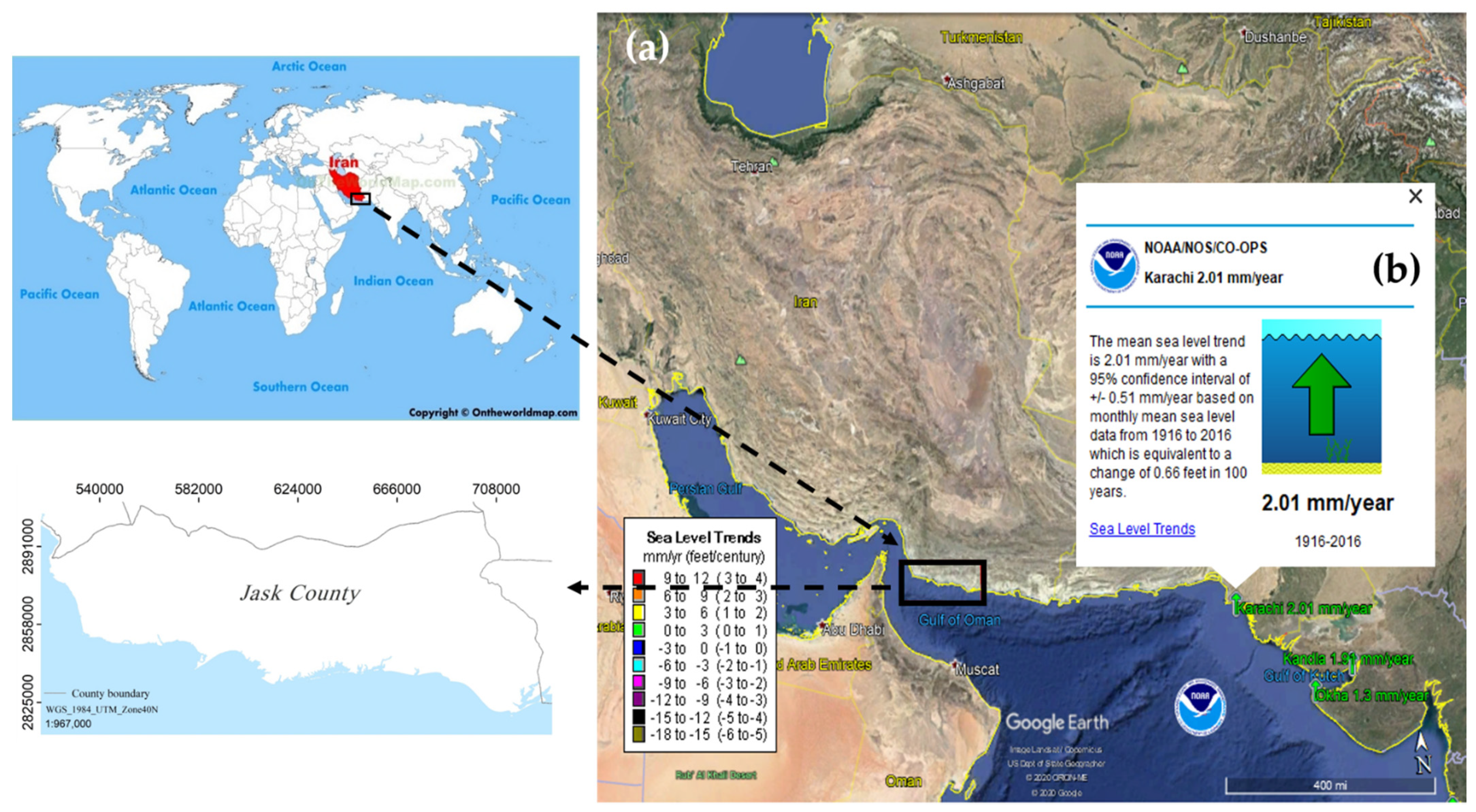
A 290 km long, less developed coastline along the Gulf of Oman, located in Jask County in the south of Iran, was selected for study (Figure 1). The Gulf of Oman, also known as Sea of Oman, Oman Sea or Makran Sea, links the Indian Ocean and Arabian Sea with the Persian Gulf through the Strait of Hormuz (Figure 1a). According to relatively long-term sea level data available from the nearest tide gauge to the study area, the Gulf of Oman has been experiencing a sea-level rise rate of 2.01 ± 0.05 mm/yr. since 1916 (Figure 1b). The coastal area that was selected as a case study is currently in an early stage of development.
3. Materials and Methods
This study was conducted through two main steps, including:
3.1. Identifying the Types of Coastal Land Cover That Will Be Inundated Due to SLR by 2100
In this research, the types of coastal lands permanently exposed to future sea-level rise was defined as the primary criteria in determining the appropriate adaptation approaches and strategies to outline the SLR adaptation framework, particularly for developing coasts. Assessing coastal land and assets exposure to SLR is a common practice for identifying coastal vulnerability and developing adaptation options and strategies to cope with future sea-level rise [11,13,14,36,60,64,65,66]. In addition, the results of coastal exposure assessments are considered as fundamental information to estimate SLR associated indirect socio-economic impacts, such as damages to gross domestic product (GDP), income, coastal assets, as well as people’s health and well-being [11,14,27,36,64]. The types of coastal land cover that will be inundated due to SLR by 2100 were identified through permanent inundation modeling and land cover exposure assessment, as described below:
3.1.1. Permanent Inundation Mapping
Translating sea-level projections into potential permanent inundation was conducted through running a common and well-accepted modified bathtub model, developed by the National Oceanic and Atmospheric Administration (NOAA) in 2017 [67]. In this model, three main input data set were used to create the permanent inundation map including: (1) a verified high resolution DEM layer (at 0.5 m elevation intervals) derived from 1:5000 topographic maps [68,69]; (2) projected global sea-level rise by 2100 for all RCP scenarios (Table 1), presented in the IPCC fifth assessment report [25]; and (3) local variations of mean higher high water (MHHW). The tidal information for the study area was recorded by four tide gauges (Table 2) over about 18 years [68]. The inundation mapping was carried out in ArcGIS software.
3.1.2. Coastal Land Cover Exposure Assessment to SLR
Employing the overlay function in ArcGIS software and two sets of data, including: (1) SLR inundation map, created in this study; and (2) a verified land cover layer of the study area, derived from 30 m Landsat 8 images (dated 2016) [68], the land cover exposure map was created. The output layer showed what types of coastal land cover will be permanently inundated due to high-end estimates of SLR by 2100 for all climate change RCP scenarios.
3.2. Outlining an SLR Adaptive Management Framework
Considering the types of lands exposed to future SLR (identified in this research), the current and future state of a developing coast, as well as the experiences from various climate change adaptation plans, we outlined a spatial adaptive management plan aimed at reducing coastal exposure to SLR. Exposure reduction is an effective SLR adaptation approach in increasing adaptive capacity of both natural and human coastal systems and consequently reducing coastal vulnerability to rising sea level [11]. In this study, five main components were employed to develop a new adaptation framework. Each of these elements come from well-accepted references in the field of climate change (as cited in associated descriptions) and have broadly been employing in SLR vulnerability and adaptation studies through various pathways. The concept of the components that were incorporated into the proposed adaptation plan to lead coastal communities to adapt to SLR on both short and long term basis are described below:
(1) Relative sea-level rise (rSLR) projection: On average, global sea level is rising due to climatic factors including thermal expansion of seawater and melting of glaciers (absolute or eustatic sea-level change). However, the sea surface is not changing at the same rate at all points around the globe because of regional/local processes such as vertical land motion and long-term ocean currents. As a result, sea-level rise at specific locations can differ from the global average. Sea-level change, influenced by local factors, is known as relative sea-level rise and is defined as a regional change in sea level relative to land surface elevations. Relative sea-level rise is a combination of climate-induced global mean sea-level rise (GMSLR) and regional variation of climate/ocean phenomena and local non-climate-related sea level changes due to vertical land motion including subsidence and uplift [7,9,11,70]. According to IPCC, relative sea-level changes projections would likely be more accurate compared to global mean sea-level rise projections, and needs to be considered in coastal SLR vulnerability and adaptation studies [11]. Hence, in this research, rSLR projection was integrated into the proposed adaptive management plan framework.
(2) Coastal exposure assessment: The initial and critical step in adapting to sea-level rise is to identify coastal areas that will be exposed to permanent inundation as well as episodic coastal flooding. In this research, considering advantages and limitations of SLR exposure assessment models, static inundation and dynamic flood modeling were integrated into the proposed adaptation framework. The concept of both the models are descried below:
a. Static (permanent) inundation modeling concept: This model, also called a bathtub approach or passive flood modelling, is the most commonly used method to identify and map the extent of permanent inundation for a particular extreme water level. Bathtub approach maps long-term SLR on top of a local or regional static tide level such as mean higher high water (MHHW) and evaluates inundation for hydrological connectivity in a geographic information system (GIS) [67].
The static inundation modeling is a reasonable approach in mapping permanent inundation due to higher sea levels, and provides useful and preliminary data to assess coastal vulnerability to future sea-level rise impacts and develop SLR adaptation plans. However, the bathtub model has several limitations which should be considered in SLR exposure and vulnerability studies. In this approach, the assumption is waves have no effect on water level [67]. Furthermore, the bathtub model does not consider dynamic processes such as coastal erosion, land motion, seasonal storm, swell, and other ocean and atmospheric phenomena which can cause extensive inundation along low-lying coasts. Because of these limitations, and depending on the spatial and time scale of the study, passive flood mapping will likely underestimate [66,71] or overestimate [27] the extent of coastal exposure to rising sea level. Hence, the concept of dynamic flood modeling has been produced to provide more comprehensive sea-level rise related exposure maps [36,72], particularly maps of coastal episodic flooding.
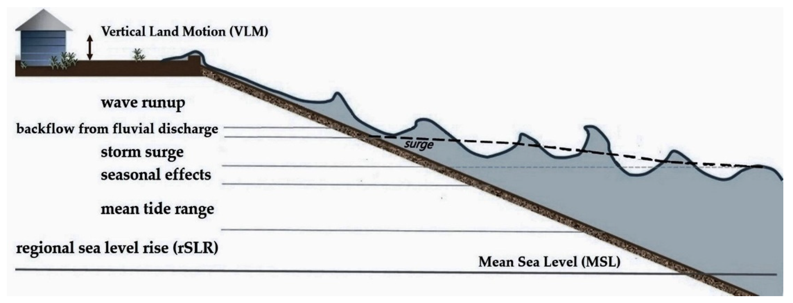
b. Dynamic flood modeling concept: Coastal areas can be significantly damaged by episodic extreme events such as intensified flooding, where climate change-induced mean sea-level rise contributes to increased coastal high water levels in the future, and would be accompanied by major socio-economic and environmental impacts. Increased dynamic processes such as water levels (Figure 2) due to SLR could amplify the exposure of land, population, assets, and ecosystems to coastal flooding [11,36,71,73]. As a result, identifying the extent of coastal land exposure to dynamic flooding is a critical step in defining and employing the appropriate adaptation approaches and strategies to reduce the associated impacts.
In addition to all the advantages of dynamic flood models, it is important to note that these models are still evolving as the studies on SLR effects on water level, storm surge severity, flooding frequency, and other complex natural process such as coastal erosion continue to advance. Hence, in the areas that such complex sea-level rise-related impacts are still relatively unknown, a permanent inundation modeling can be considered as a primary tool to develop an appropriate SLR adaptation plans. Additionally, the approaches and strategies to adapt to permanent inundation and episodic flooding can be different, particularly on short-term basis adaptation plans.
(3) Spatial land management tools principles: Land evaluation, land suitability, and land-use planning are known as effective tools for managing both existing and potential future development in both inland and coastal zones. These tools are also practical in the context of adaptive management. After mapping the exposed coastal lands to sea-level rise, land management tools can be successfully employed to keep the identified exposed lands from future development. In addition, land management approaches and land use planning, in particular, can be used to manage developed coasts that are at risk of SLR-induced impacts. Sea-level rise inundation and flood hazard zoning are two example of adaptation strategies that can be implemented through land use planning studies in developed coastal areas. The spatial land management tools that were incorporated into the proposed adaptation plan are listed and described below:
a. Land evaluation concept: Land evaluation is an approach to determine whether the land is physically suitable and economically and socially relevant for specific types of uses. In general, urban, rural, industrial, agriculture, forestry, recreation, and nature conservation are identified as major land uses. Land evaluation can be done through assessing a specific set of land qualities (e.g., resistance to soil erosion, water availability, ease of cultivation, etc.) [74,75,76].
b. Land suitability assessment concept: Compared to land evaluation, land suitability assessment is a more detailed analysis, which determines the adaptability of a given area for a specific kind of land use (e.g., desalination plant, power plant, shrimp farming, refinery, etc.) [74,75,76].
c. Land use planning concept: This land management tool is defined as “A systematic assessment of land and water potential, alternatives for land use and economic and social conditions in order to select and adopt the best land-use options” [76]. Land evaluation and land suitability assessment have been recognized as two key elements in land-use planning, which is a primary tool for sustainable development [74,75,76]. Development of more efficient land use patterns in coastal zones is an important aspect of planning that can be used to choose the most appropriate SLR adaptation options for the area of concern, particularly on developing coasts.
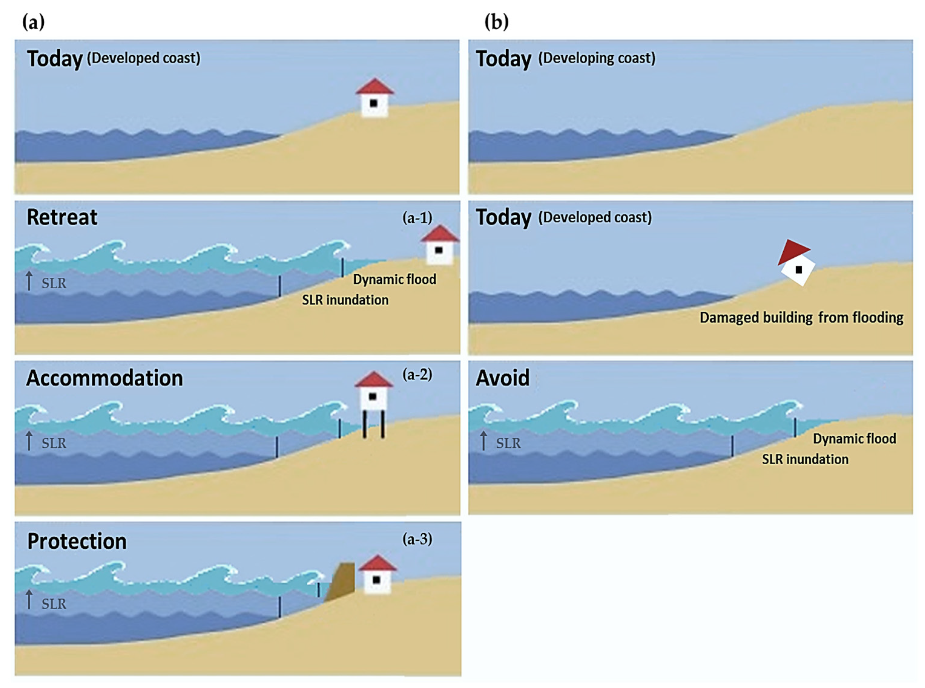
(4) Adaptation strategies: Four broadly used SLR adaptation strategies (Figure 3) were also integrated into the outlined adaptive management framework including:
a. Retreat: In this option there is no effort to protect coastal land from SLR. Man-made structures can be relocated and ecosystems can shift landward (Figure 3(a-1)).
b. Accommodation: This implies that people continue to use the lands that are at risk through elevating buildings, changing the land use (e.g., farmland to aquaculture), etc. (Figure 3(a-2)).
c. Protection: This strategy involves building hard (gray) structures (seawalls/rip-rap revetments) as well as establishing soft (green) solutions, where feasible, to protect coastal lands and assets from SLR impacts (Figure 3(a-3)).
d. Avoid: This is defined as an adaptation option to reduce exposure to projected SLR on developing coasts, as well as in areas that have already been damaged due to SLR-induced flood events (Figure 3b). Avoidance is a proactive practice that prevents any development or re-building in hazard zones such as flood plains or in areas that would be inundated due to future sea-level rise. This adaptation strategy can be planned and implemented through land-use regulation and zoning approaches. The avoid strategy is also useful where salt marsh/mangrove forests, as well as beaches and coastal cliffs, are able to migrate inland in response to rising sea level and need adequate undeveloped land in order to move landward. Avoid strategy also encourages coastal planners to avoid short term solutions such as gray protection in the areas that are at risk of sea-level rise related hazards including permanent inundation, storm surges, and more frequent flooding.
(5) Climate change adaptation cycle: The final step in developing the adaptation plan was to incorporate the elements of a well-known and broadly used climate change adaptation cycle into the proposed adaptation framework, including implement, monitor, evaluate, and learn and adjust. These four core steps of the iterative process will turn the adaptive management plan into a dynamic and continuous approach, and consequently have an important role in successfully implementing and improving the climate change adaptation plans.
4. Results
4.1. The Extent of Permanent SLR Inundation
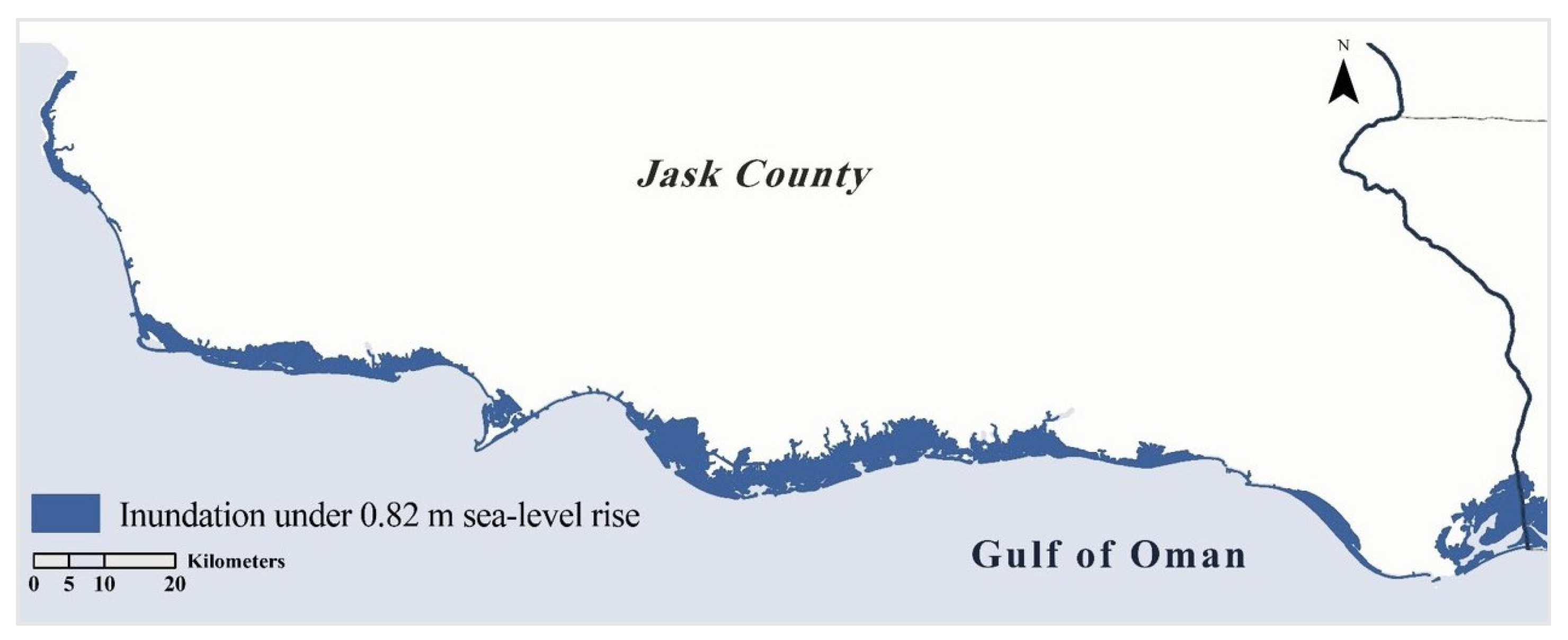
The results of inundation mapping (Figure 4) indicated around 300, 334, and 450 square km of the coast will be inundated under 0.55, 0.63, and 0.82 m SLR by 2100, respectively.
4.2. The Types of Coastal Land That Will Be Inundated Due to SLR by 2100
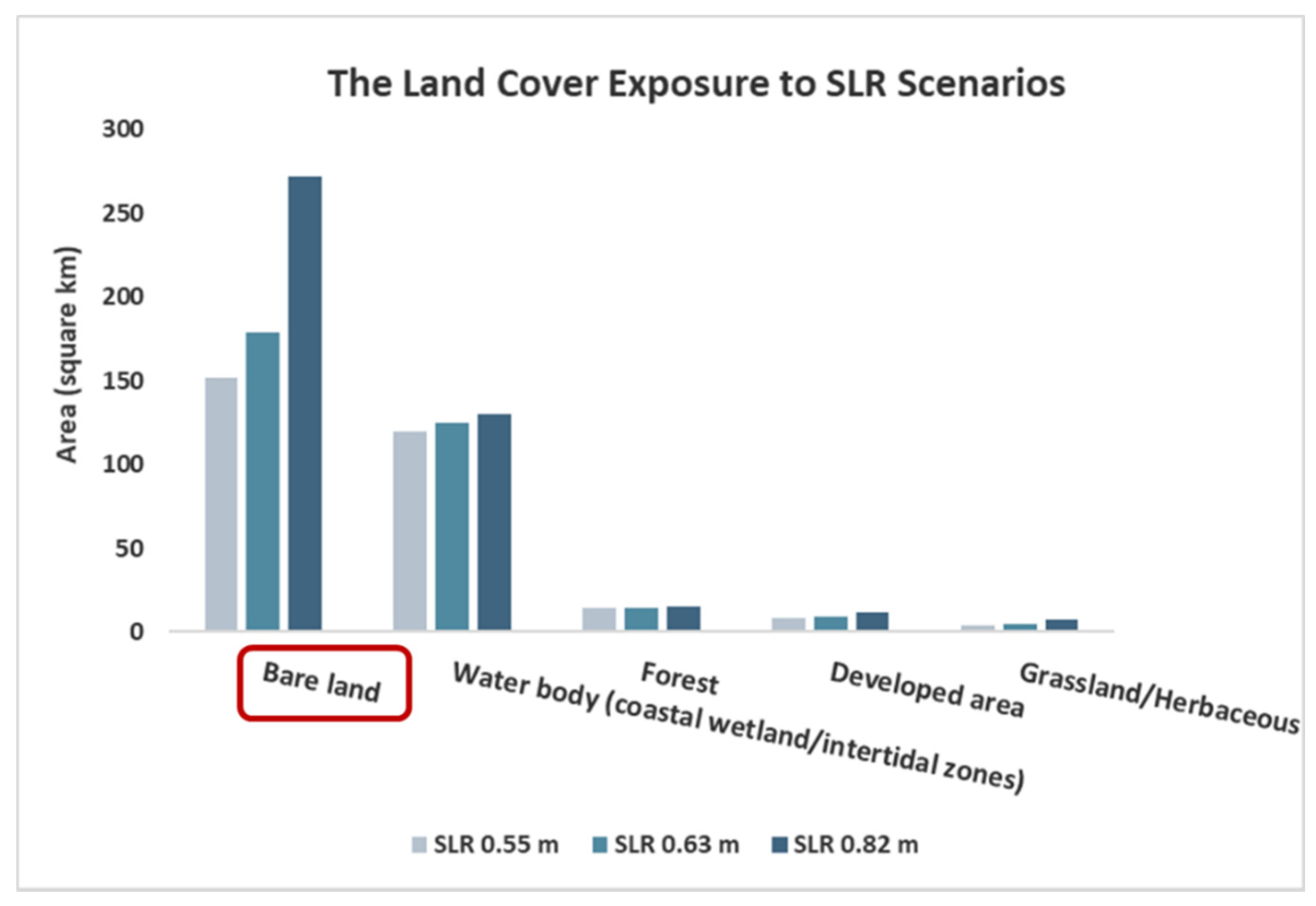
The result of land cover exposure assessment showed that five classes of coastal land cover would potentially be flooded permanently due to the high-end estimates of SLR (0.55, 0.63, and 0.82 m) by 2100 (Figure 5). Bare land, water bodies (such as coastal wetlands that mostly support mangroves), forest, developed areas, and grasslands are the types of coastal lands that will be exposed to future sea-level rise.
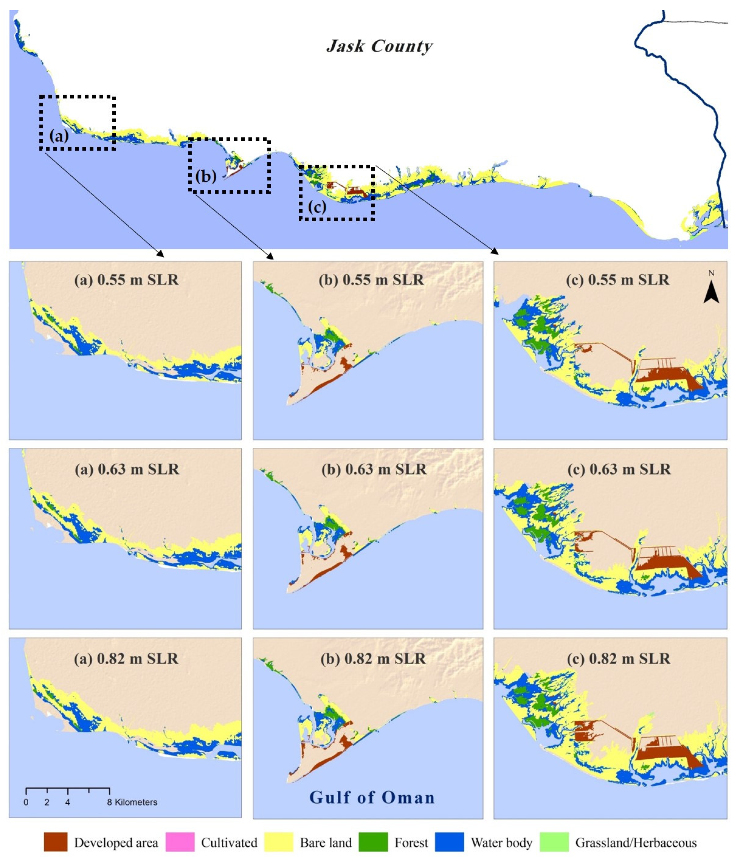
The land cover SLR exposure mapping (Figure 6) indicates that among the five types of inundated coastal land cover, bare land has the highest exposure to SLR (Figure 5). Bare lands are the types of land cover that are potentially considered for development. As a result, it would be critical to keep the exposed bare lands from future development. The outcome of land cover exposure assessment led us to employ the principles of spatial (map-based) land management tools as practical approaches in reducing coastal exposure to future sea-level rise and associated impacts.
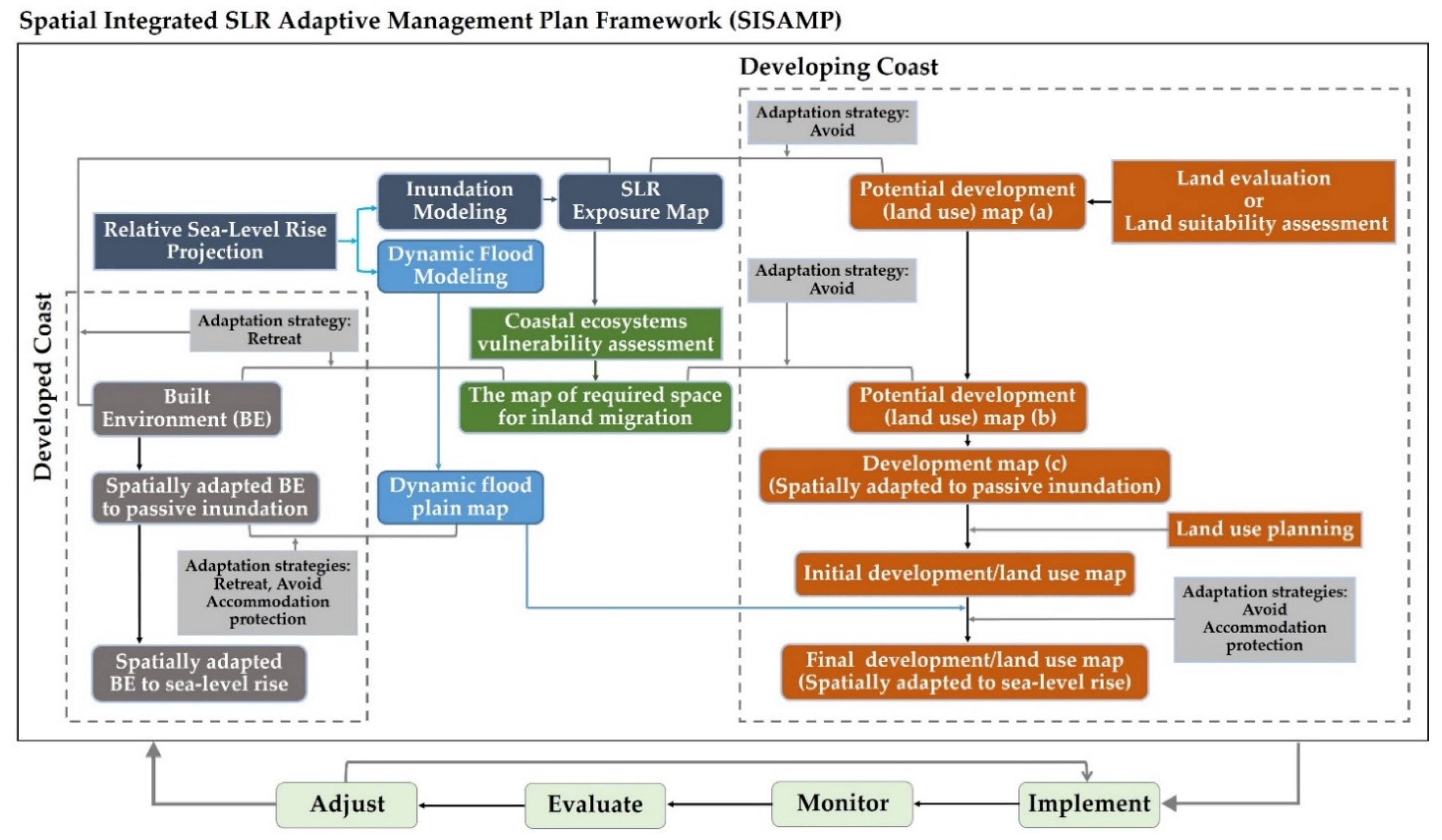
4.3. A Conceptual Framework of the SLR Adaptation Plan
The result of land cover exposure assessment, the general state of undeveloped and developing coasts, as well as considering the experiences from existing adaptation plans, led us to outline a map-based adaptation framework based on exposure reduction approach. The key elements of the proposed conceptual adaptation plan (Figure 7), labeled: Spatial Integrated SLR Adaptive Management Plan Framework (SISAMP) are: (1) Relative sea-level rise; (2) the concept of coastal exposure assessment models (static inundation and dynamic flood modeling); (3) the principles of spatial land management tools (including land evaluation, land suitability, land-use planning); (4) the common SLR adaptation strategies (including retreat, accommodation, protection and avoid) and; (5) the elements of a well-known and broadly used iterative process of climate change adaptive management (including implement, monitor, evaluate and learn and adjust). The concept of the five components were described in detail in the materials and methods section.
In the presented adaptation conceptual model, permanent and dynamic coastal exposure assessment to relative sea-level changes and conducting coastal ecosystems vulnerability studies were set as initial steps toward coastal adaptation. The exposure maps would be used as the main input data in the outlined adaptation plan for developing coasts (Figure 7, right panel). In this framework, spatial land management tools are the set of concepts that would have critical roles in reducing the potential exposure of future development to climate change-induced coastal hazards. Land evaluation and land suitability assessment outputs would represent the suitable areas for development. The potential development map, permanent exposure, and the map of coastal ecosystem vulnerability together would provide the spatial information about the areas that should be protected from future development through avoidance strategy. The next step would be to integrate land-use planning map, also known as land-use zoning, with dynamic flood modeling output to decide which development/s should not be implemented in the areas that are at flood risk zones and which land uses can be developed in a flood plain. In the land use zoning process, three adaptation strategies, including avoid, accommodation, and protection, would be employed to provide the final land use map. The main outcome of this framework would be a sustainable coastal development plan which is spatially adapted to future sea-level rise. This plan would also preserve the land needed for coastal wetlands to migrate inland to keep pace with changing sea level.
The proposed adaptation framework would also be applicable in developed coasts through considering the adaptation outline that has been developed and embedded in the conceptual model (Figure 7, left panel). The sea-level rise adaptation plan for developed coasts would also begin with mapping of both permanent inundation and dynamic flood under relative sea-level rise. The type of exposure map would determine the most appropriate adaptation measure to reduce coastal exposure to SLR. The permanent inundation map, integrated with the ecosystem vulnerability assessment outcome, would provide the spatial distribution of the areas that would need to adapt to SLR impacts through retreat strategy. For the areas that will episodically be flooded, the appropriate adaptation strategy to reduce SLR vulnerability would depend on land use as well as the history of coastal hazards such as flooding. The result of implementing this adaptation plan would be a spatially adapted coast through reducing built environment exposure to SLR. In addition, this plan would increase the adaptive capacity of vulnerable coastal wetlands by removing barriers to wetlands inland migration on developed coasts.
The proposed adaptation framework would also prevent coastal squeeze in both developed and developing coasts by enabling beaches to migrate landward as sea level rises.
The climate change adaptive management plan can be improved and updated through the iterative process elements including implement, monitor, evaluate, and learn and adjust that have been integrated into the proposed spatial SLR adaptation framework. All the elements, approaches, and strategies that have been integrated into the outlined adaptation framework, combined together, can effectively reduce SLR vulnerability through reducing both future development and the existing built environment exposure to rising sea level and its impacts.
5. Discussion
5.1. Land Cover SLR Exposure
Assessing physical exposure of the study area to climate change-induced sea-level rise showed that the studied coastal area will be affected under all climate change scenarios. This is consistent with the results of a number of studies that stated the Gulf of Oman is experiencing both sea surface temperature (SST) [77] and regional sea-level rise increases [63,78,79] due to global climate change. In addition, the Gulf of Oman coast has been ranked among the world’s most vulnerable coasts to SLR [22]. The result of land cover exposure to SLR indicated that, of the total submerged coastal lands, 59%, 61%, and 69% are bare lands that will be inundated under 0.55, 0.63 and 0.82 m, respectively. This is a significant outcome because bare lands are being considered for potential development. As a result, on developing coasts, the exposed bare lands could be categorized as potentially vulnerable coastal lands to sea-level rise impacts. Water bodies, including coastal wetlands (mangroves, in particular), are the second most exposed land cover to SLR in the study area. The exposed coastal wetlands could potentially migrate inland to adapt to rising sea-level if they do not encounter any natural or man-made barriers [11,39,80]. Hence, it is important to identify suitable lands for coastal wetlands migration and avoid development of these areas. A similar strategy would be applicable in the areas where beaches or sea cliffs could retreat inland due to coastal erosion [11,26,81]. Considering the “avoid” adaptation option on developing coasts could preserve coastlines and beaches where coastal erosion has been accelerated under rising sea level and associated extreme events. Furthermore, as 3% of exposed land covers are built environments, it is essential to integrate vulnerability study results into the coastal management plans in a timely way to avoid future unsustainable developments, where implementing adaptation strategies such as protection and retreat will be more costly [11,35,82].
5.2. Adaptation to Sea-Level Rise
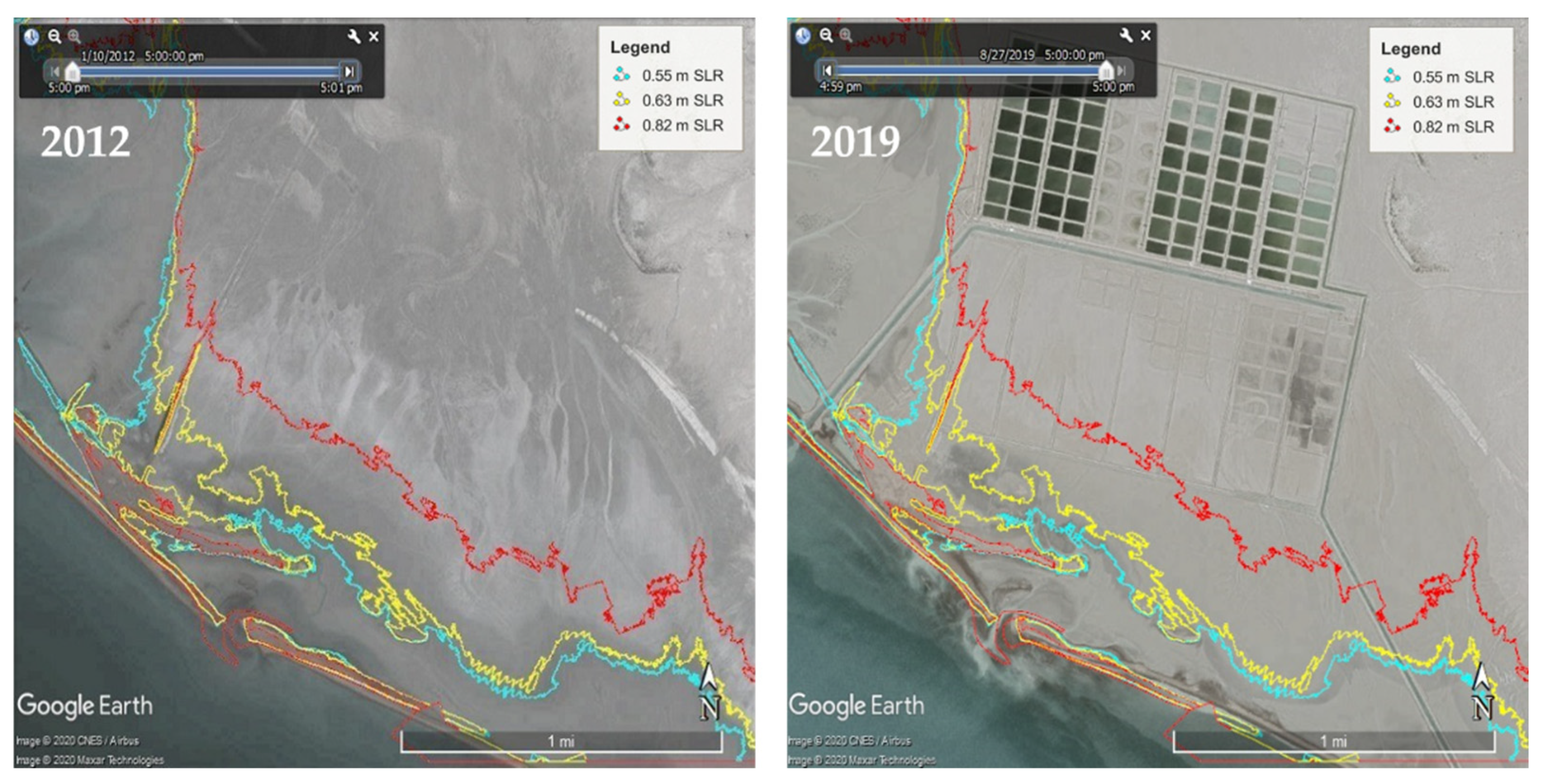
According to latest census information, from 2016, the study area, as an example of a developing coast, falls into the less-density category with 15–16 people per square km [83]. However, the studied coast is extended along a coastal county that has a relatively high population annual growth rate (1.5–2.5%) and its coastal area is in an early stage of development. Due to expected population growth and development, coastal exposure and, consequently, coastal vulnerability to rising sea level will also increase. In the absence of an adaptation plan, development of potentially vulnerable coastal lands to future sea-level rise is an example of the “do nothing” strategy in response to climate change, which would lead to unsustainable coastal development (Figure 8).
The coastal exposure assessment result as well as the investigation of the current state of the study area, as an example of a developing coast, led us to develop a Spatial Integrated SLR Adaptive Management Plan Framework based on an exposure reduction approach. Spatial land management is a fundamental element in the proposed SLR adaptation plan framework, which would lead coastal communities to avoid/prevent or reduce future sea-level rise impacts. Spatial planning is recognized as a practical approach in both climate change mitigation and adaptation plans, and spatial land management tools are used as effective measures to adapt to or mitigate climate change consequences [84,85,86,87,88]. A study of adaptive capacity to climate change emphasizes the importance of integrative planning in climate change adaptation and suggests incorporating the science of land use and land cover into adaptive management plans to manage risks [89].
In a paper targeting flood risk management, it is recommended to integrate spatial planning, engineering, and insurance approaches in order to provide a more practical adaptive management plan to reduce flooding impacts in urban area [90]. In the SLR adaptation framework developed in this research, three main tools of spatial land management, including land suitability, land evaluation, and land-use planning, were employed to manage coastal lands in order to reduce hazard exposure. It is also recommended to manage coastal lands through land-use planning as a potential adaptation option (e.g., making changes in parcel shape, size and zoning of urban areas), which can provide significant opportunities for mitigation and adaptation to climate change [85,91]. For example, in a study on potential SLR adaptation planning on the Florida coast, a land-use planning adaptation was recommended for a coastal community to cope with accelerating sea-level rise [92]. Similarly, in a proposed adaptation plan for Los Angeles, zoning of land uses was suggested as an adaptation measure to minimize the risks of coastal hazards, such as flooding in their coastal zone [45]. Compared to the reviewed literature that was mainly focused on climate change mitigation and adaptation options in built environment (e.g., urban areas), the proposed SLR adaptation framework in this study could be applicable in both developed and developing coasts. In addition, incorporating both passive inundation and a dynamic flood concept into an adaption framework provides a more practical and flexible SLR adaptation plan to manage coastal lands that are subject to permanent or episodic flooding unfolding over different time-scales from hours to decades.
The information provided from this research, through a SLR exposure assessment and a proposed comprehensive SLR conceptual adaptation plan, can guide coastal planners in keeping areas exposed to SLR from future development. In addition, adaptation plans are effective tools to reduce coastal vulnerability through increasing the adaptive capacity of natural environments and human communities. SLR adaptation strategies can assist decision-making and allow policy makers to choose/adopt the most effective management actions, rules, and regulations in order to prevent potential future damages to coastal systems and reduce the potential loss of life due to SLR-induced episodic extreme events. This can be done through employing an avoidance strategy, which restricts any new development in flood zones, or implements a managed retreat strategy through a buyout approach in the areas that will potentially be faced with dynamic flooding or permanent inundation in the future due to SLR.
It is particularly timely to take the action to adapt to climate change-induced sea-level rise where rapid development in a coastal area is occurring. Integrating adaptive management plans into existing coastal management and development plans would provide an effective, integrated, and interdisciplinary pathway to develop and manage coastal areas sustainably.
6. Conclusions
Climate change has been causing a broad range of adverse effects on both natural and human systems. Rising sea level is recognized as one the most significant climate change-induced challenges to the Earth and human development [11]. As a result, efforts are underway or being developed to reduce/cope with or avoid future SLR impacts through developing appropriate adaptation strategies for vulnerable coasts. Greater delay in the implementation of adaptation plan will make it more costly, difficult or even impossible to prevent, reduce and reverse climate change effects which would cause more loss and damage in vulnerable areas [93,94]. In this study, we outlined a Spatial Integrated SLR Adaptive Management Plan Framework (SISAMP), particularly aimed at sea-level rise exposure reduction on developing coasts. Of the many elements associated with successful adaptation [11,26,95,96], the concept of two criteria were highlighted in the proposed adaptive management framework: interdisciplinary collaboration and effective communication. We incorporated the land use planning concept into the adaptation plan, which is implemented in close collaboration with the sectors responsible for coastal land management. The spatial planning concept that integrated into the proposed adaptation framework could facilitate effective communication between adaptive management plan developers and diverse coastal stakeholders such as national decision/policy makers, local communities, private sectors, etc. This would be accomplished through visualizing vulnerable coasts, adaptation options, implementation results, and alternatives. These two elements would lead to planning practical adaptive management and implementing adaptation strategies successfully.
Limits and Future work: Climate change science is advancing and both global and regional sea-level rise projections are improving. A number of studies indicate that sea-level rise projections by IPCC are conservative and underestimate SLR magnitudes by 2100 [97,98]. In addition, regional sea-level rise can differ significantly from global sea-level rise due to a variety of factors such as regional climate and ocean phenomena and vertical land motion. Uncertainties around sea-level rise values can cause uncertainties in adaptive management strategies and will complicate the associated decision making processes [99]. Employing updated sea-level rise projections, specifically regional relative sea-level, would reduce the uncertainties in SLR exposure studies. In addition, identifying future urban growth patterns as well as land-use/land-cover changes [100] could be used to adjust the extent of built and natural environment exposure to modeled SLR inundation and dynamic flooding in coastal areas.
Adaptation cannot overcome all coastal sea-level rise impacts, but can potentially provide the opportunity to cope, avoid, or adapt to many of the identified SLR threats.
Author Contributions
L.D., A.D., A.S. designed research; L.D., A.D., A.S., H.A., B.N. and G.G., performed research; L.D., data collection and field survey; L.D. and G.G., writing, review, and editing. All authors read and agreed to the published version of the manuscript.
Funding
This research received no external funding.
Institutional Review Board Statement
Not applicable.
Informed Consent Statement
Not applicable.
Data Availability Statement
The data that support the findings of this study are available from the corresponding author upon request.
Conflicts of Interest
The authors declare no conflict of interest.
References
- Nerem, R.S.; Chambers, D.P.; Choe, C.; Mitchum, G.T. Estimating mean sea level change from the TOPEX and Jason altimeter missions. Mar. Geod. 2010, 33 (Suppl. 1), 435–446. [Google Scholar] [CrossRef]
- Cazenave, A.; Dieng, H.; Meyssignac, B.; von Schuckmann, K.; Decharme, B.; Berthier, E. The rate of sea-level rise. Nat. Clim. Chang. 2014, 4, 358–361. [Google Scholar] [CrossRef]
- Ablain, M.; Legeais, J.F.; Prandi, P.; Marcos, M.; Fenoglio-Marc, L.; Dieng, H.B.; Benveniste, J.; Cazenave, A. Satellite Altimetry-Based Sea Level at Global and Regional Scales. Surv. Geophys. 2017, 38, 7–31. [Google Scholar] [CrossRef]
- NASA. Sea Level Change Observation from the Space. 2020. Available online: https://sealevel.nasa.gov/understanding-sea-level/key-indicators/global-mean-sea-level/ (accessed on 10 May 2020).
- Church, J.A.; White, N.J. A 20th century acceleration in global sea-level rise. Geophys. Res. Lett. 2006, 33, L01602. [Google Scholar] [CrossRef]
- Church, J.A.; White, N.J. Sea-Level Rise from the Late 19th to the Early 21st Century. Surv. Geophys. 2011, 32, 585–602. [Google Scholar] [CrossRef] [Green Version]
- Church, J.A.; Clark, P.U.; Cazenave, A.; Gregory, J.M.; Jevrejeva, S.; Levermann, A.; Merrifield, M.A.; Milne, G.A.; Nerem, R.S.; Nunn, P.D.; et al. Sea Level Change. In Climate Change 2013: The Physical Science Basis. Contribution of Working Group I to the Fifth Assessment Report of the Intergovernmental Panel on Climate Change; Stocker, T.F., Qin, D., Plattner, G.-K., Tignor, M., Allen, S.K., Boschung, J., Nauels, A., Xia, Y., Bex, V., Midgley, P.M., Eds.; Cambridge University Press: Cambridge, UK; New York, NY, USA, 2013. [Google Scholar]
- Nerem, R.S.; Beckley, B.D.; Fasullo, J.T.; Hamlington, B.D.; Masters, D.; Mitchum, G.T. Climate-change-driven accelerated sea-level rise detected in the altimeter era. Proc. Natl. Acad. Sci. USA 2018, 115, 2022–2025. [Google Scholar] [CrossRef] [PubMed] [Green Version]
- Griggs, G. Coast in Crisis: A Global Challenge; University of California Press: Oakland, CA, USA, 2017; p. 360. [Google Scholar]
- Weeman, K.; Lynch, P. New Study Finds Sea Level Rise Accelerating; NASA: Greenbelt, MD, USA, 2018. Available online: https://climate.nasa.gov/news/2680/new-study-finds-sea-level-rise-accelerating/ (accessed on 1 February 2019).
- IPCC. Climate Change 2014: Impacts, Adaptation, and Vulnerability. Part A: Global and Sectoral Aspects. Contribution of Working Group II to the Fifth Assessment Report of the Intergovernmental Panel on Climate Change; Field, C.B., Barros, V.R., Dokken, D.J., Mach, K.J., Mastrandrea, M.D., Bilir, T.E., Chatterjee, M., Ebi, K.L., Estrada, Y.O., Genova, R.C., et al., Eds.; Cambridge University Press: Cambridge, UK; New York, NY, USA, 2014; p. 1132. [Google Scholar]
- Nicholls, R.J. Chapter 2-Adapting to Sea-Level Rise. In Resilience: The Science of Adaptation to Climate Change; Zommers, Z., Alverson, K., Eds.; Elsevier: Oxford, UK, 2018; pp. 13–29. ISBN 978-0-12-811891-7. [Google Scholar] [CrossRef]
- Toimil, A.; Losada, I.J.; Nicholls, R.; Dalrymple, R.A.; Stive, M.J. Addressing the challenges of climate change risks and adaptation in coastal areas: A review. Coast. Eng. 2020, 156, 103611. [Google Scholar] [CrossRef]
- Nicholls, R.J.; Wong, P.P.; Burkett, V.; Codignotto, J.; Hay, J.; McLean, R.; Ragoonaden, S.; Woodroffe, C.D.; Abuodha, P.A.O.; Arblaster, J.; et al. Coastal systems and low-lying areas. In Climate Change 2007: Vulnerability, Impacts and Adaptation, Contribution of Working Group II to the IPCC Fourth Assessment Report; Parry, M.L., Canziani, O.F., Palutikof, J.P., Van der Linden, P.J., Hanson, C.E., Eds.; Cambridge University Press: Cambridge, UK, 2007; pp. 315–356. [Google Scholar]
- McGranahan, G.; Balk, D.; Anderson, B. The rising tide: Assessing the risks of climate change and human settlements in low elevation coastal zones. Environ. Urban. 2007, 19, 17–37. [Google Scholar] [CrossRef]
- Neumann, B.; Vafeidis, A.T.; Zimmermann, J.; Nicholls, R.J. Future coastal population growth and exposure to sea-level rise and coastal flooding—A global assessment. PLoS ONE 2015, 10, e0131375. [Google Scholar] [CrossRef] [Green Version]
- MEA (Millennium Ecosystem Assessment). Ecosystems and Human Well-Being: Synthesis; Island Press: Washington, DC, USA, 2005. [Google Scholar]
- Hadwen, W.; Capon, S. Navigating from climate change impacts to adaptation actions in coastal ecosystems. In Applied Studies in Climate Adaptation; Sarah, J.P.P., Boulter, L., Barnett, J., David, R., Eds.; Wiley Blackwell: Chichester, UK, 2015; pp. 190–199. [Google Scholar]
- Moser, S.C. Raising the seas, rising to greatness? Meeting the challenge of coastal climate change. In Applied Studies in Climate Adaptation; Palutikof, J.P., Boulter, S.L., Barnett, J., Rissik, D., Eds.; Wiley: Oxford, UK, 2014; pp. 177–180. [Google Scholar]
- Martínez, M.; Intralawan, A.; Vázquez, G.; Pérez-Maqueo, O.; Sutton, P.; Landgrave, R. The coasts of our world: Ecological, economic and social importance. Ecol. Econ. 2007, 63, 254–272. [Google Scholar] [CrossRef]
- Merkens, J.-L.; Reimann, L.; Hinkel, J.; Vafeidis, A. Gridded population projections for the coastal 439 zone under the Shared Socioeconomic Pathways. Glob. Planet. Chang. 2016, 145, 57–66. [Google Scholar] [CrossRef] [Green Version]
- Nicholls, R.J.; Cazenave, A. Sea-Level Rise and Its Impact on Coastal Zones. Science 2010, 328, 1517–1520. [Google Scholar] [CrossRef]
- Griggs, G.; Davar, L.; Reguero, B.G. Documenting a Century of Coastline Change along Central California and Associated Challenges: From the Qualitative to the Quantitative. Water 2019, 11, 2648. [Google Scholar] [CrossRef] [Green Version]
- Cazenave, A.; Cozannet, G. Sea level rise and its coastal impacts. Earth’s Future 2013, 2, 15–34. [Google Scholar] [CrossRef]
- IPCC. Climate Change 2014: Synthesis Report. Contribution of Working Groups I, II and III to the Fifth Assessment Report of the Intergovernmental Panel on Climate Change; Core Writing Team, Pachauri, R.K., Meyer, L.A., Eds.; IPCC: Geneva, Switzerland, 2014; p. 151. [Google Scholar]
- Oppenheimer, M.; Glavovic, B.C.; Hinkel, J.; van de Wal, R.; Magnan, A.K.; Abd-Elgawad, A.; Cai, R.; Cifuentes-Jara, M.; DeConto, R.M.; Ghosh, T.; et al. Sea Level Rise and Implications for Low-Lying Islands, Coasts and Communities. In IPCC Special Report on the Ocean and Cryosphere in a Changing Climate; Pörtner, H.-O., Roberts, D.C., Masson-Delmotte, V., Zhai, P., Tignor, M., Poloczanska, E., Mintenbeck, K., Alegría, A., Nicolai, M., Okem, A., et al., Eds.; Cambridge University Press: Cambridge, UK, 2019; pp. 341–425, in press. [Google Scholar]
- Kulp, S.A.; Strauss, B.H. New elevation data triple estimates of global vulnerability to sea-level rise and coastal flooding. Nat. Commun. 2019, 10, 4844. [Google Scholar] [CrossRef] [Green Version]
- Neumann, J.E.; Yohe, G.; Nicholls, R.J.; Manion, M. Sea level rise and its effects on global resources. In Climate Change: Science, Strategies, and amp; Solutions; Claussen, E., Cochran, V.A., Davis, D.P., Eds.; Brill: Boston, MA, USA, 2001; pp. 43–62. [Google Scholar]
- Vitousek, S.; Barnard, P.L.; Fletcher, C.H.; Frazer, N.; Erikson, L.; Storlazzi, C.D. Doubling of coastal flooding frequency within decades due to sea-level rise. Sci. Rep. 2017, 7, 1399. [Google Scholar] [CrossRef] [PubMed]
- Anthoff, D.; Nicholls, R.; Tol, R. The economic impact of substantial sea-level rise. Mitig. Adapt. Strat. Glob. Chang. 2010, 15, 321–335. [Google Scholar] [CrossRef]
- The World Bank. Climate Risks and Adaptation in Asian Coastal Megacities, A Synthesis Report; The World Bank: Washington, DC, USA, 2010; p. 121. [Google Scholar]
- Hanson, S.; Nicholls, R.; Ranger, N.; Hallegatte, S.; Corfee-Morlot, J.; Herweijer, C.; Chateau, J. A global ranking of port cities with high exposure to climate extremes. Clim. Chang. 2010, 104, 89–111. [Google Scholar] [CrossRef] [Green Version]
- Kron, W. Coasts: The high-risk areas of the world. Nat. Hazards 2013, 66, 1363–1382. [Google Scholar] [CrossRef]
- Hallegatte, S.; Green, C.; Nicholls, R.; Corfee-Morlot, J. Future flood losses in major coastal cities. Nat. Clim Chang. 2013, 3, 802–806. [Google Scholar] [CrossRef]
- Hinkel, J.; Lincke, D.; Vafeidis, A.; Perrette, M.; Nicholls, R.; Tol, R.; Marzeion, B.; Fettweis, X.; Ionescu, C.; Levermann, A. Coastal flood damage and adaptation costs under 21st century sea-level rise. Proc. Natl. Acad. Sci. USA 2014, 111, 3292–3297. [Google Scholar] [CrossRef] [Green Version]
- Barnard, P.L.; Erikson, L.H.; Foxgrover, A.C.; Hart, J.A.F.; Limber, P.; O’Neill, A.C.; Van Ormondt, M.; Vitousek, S.; Wood, N.; Hayden, M.K.; et al. Dynamic flood modeling essential to assess the coastal impacts of climate change. Sci. Rep. 2019, 9, 4309. [Google Scholar] [CrossRef] [Green Version]
- Vitousek, S.; Barnard, P.L.; Limber, P.; Erikson, L.; Cole, B. A model integrating longshore and cross-shore processes for predicting long-term shoreline response to climate change. J. Geophys. Res. Earth Surf. 2017, 122, 782–806. [Google Scholar] [CrossRef]
- Limber, P.W.; Barnard, P.L.; Vitousek, S.; Erikson, L.H. A model ensemble for projecting multidecadal coastal cliff retreat during the 21st century. J. Geophys. Res. Earth Surf. 2018, 123, 1566–1589. [Google Scholar] [CrossRef]
- Schuerch, M.; Spencer, T.; Temmerman, S.; Kirwan, M.L.; Wolff, C.; Lincke, D.; McOwen, C.J.; Pickering, M.; Reef, R.; Vafeidis, A.; et al. Future response of global coastal wetlands to sea-level rise. Nature 2018, 561, 231–234. [Google Scholar] [CrossRef] [PubMed]
- Myers, M.R.; Barnard, P.L.; Beighley, E.; Cayan, D.R.; Dugan, J.E.; Feng, D.; Hubbard, D.M.; Iacobellis, S.F.; Melack, J.M.; Page, H.M. A multidisciplinary coastal vulnerability assessment for local government focused on ecosystems, Santa Barbara area, California. Ocean Coast. Manag. 2019, 182, 104921. [Google Scholar] [CrossRef] [Green Version]
- Klein, R.J.T.; Nicholls, R.J.; Ragoonaden, S.; Capobianco, M.; Aston, J.; Buckley, E.H. Technological options for adaptation to climate change in coastal zone. J. Coast. Res. 2001, 17, 531–543. [Google Scholar]
- Tol, R.S.J.; Klein, R.J.T.; Nicholls, R.J. Towards Successful Adaptation to sea-level rise along Europe’s Coasts. J. Coast. Res. 2008, 24, 432–442. [Google Scholar] [CrossRef] [Green Version]
- Pettita, C.J.; Russel, A.B.M. A Spatial Decision Support System Framework for Climate Change Adaptation in Victoria. In Proceedings of the XXI Congress of the International Society for Photogrammetry and Remote Sensing (ISPRS), Beijing, China, 3–11 July 2008; Volume Xxxvii. Part B2. [Google Scholar]
- Nicholls, R. Planning for the impacts of sea level rise. Oceanography 2011, 24, 144–157. [Google Scholar] [CrossRef]
- Aerts, J.C.; Barnard, P.L.; Botzen, W.; Grifman, P.; Hart, J.F.; De Moel, H.; Mann, A.N.; de Ruig, L.; Sadrpour, N. Pathways to resilience: Adapting to sea level rise in Los Angeles. Ann. N. Y. Acad. Sci. 2018, 1427, 1–90. [Google Scholar] [CrossRef] [PubMed] [Green Version]
- Wigand, C.; Ardito, T.; Chaffee, C.; Ferguson, W.; Paton, S.; Raposa, K.B.; Vandemoer, C.; Watson, E. A Climate Change Adaptation Strategy for Management of Coastal Marsh Systems. Chesap. Sci. 2017, 40, 682–693. [Google Scholar] [CrossRef]
- Reguero, B.G.; Beck, M.W.; Bresch, D.N.; Calil, J.; Meliane, I. Comparing the cost effectiveness of nature-based and coastal adaptation: A case study from the Gulf Coast of the United States. PLoS ONE 2018, 13, e0192132. [Google Scholar] [CrossRef] [PubMed] [Green Version]
- Lorie, M.; Neumann, J.E.; Sarofim, M.C.; Jones, R.; Horton, R.M.; Kopp, R.E.; Fant, C.; Wobus, C.; Martinich, J.; O’Grady, M.; et al. Modeling coastal flood risk and adaptation response under future climate conditions. Clim. Risk Manag. 2020, 29, 100233. [Google Scholar] [CrossRef]
- Dronkers, J.; Gilbert, J.; Butler, T.E.; Carey, L.W.; Campbell, J.J.; James, J.; McKenzie, E.; Misdorp, C.; Quin, R.; Ries, N.; et al. Strategies for Adaption to Sea Level Rise. Report of the IPCC Coastal Zone Management Subgroup: Intergovernmental Panel on Climate Change; Intergovernmental Panel on Climate Change: Geneva, Switzerland, 1990. [Google Scholar]
- Colls, A.; Ash, N.; Ikkala, N. Ecosystem-Based Adaptation: A Natural Response To Climate Change; IUCN: Gland, Switzerland, 2009. [Google Scholar]
- Torlazzi, C.D.; Reguero, B.G.; Cole, A.D.; Lowe, E.; Shope, J.B.; Gibbs, A.E.; Nickel, B.A.; McCall, R.T.; van Dongeren, A.R.; Beck, M.W. Rigorously valuing the role of U.S. coral reefs in coastal hazard risk reduction. Geol. Surv. Open-File Rep. 2019, 42. [Google Scholar] [CrossRef] [Green Version]
- Nicholls, R.J.; Klein, R.J.T.; Tol, R.S.J. Managing coastal vulnerability and climate change: A national to global perspective. In Managing Coastal Vulnerability; McFadden, L., Nicholls, R., Penning-Roswell, E., Eds.; Elsevier: Oxford, UK, 2007; pp. 223–241. [Google Scholar]
- Marino, E. Adaptation privilege and Voluntary Buyouts: Perspectives on ethnocentrism in sea level rise relocation and retreat policies in the US. Glob. Environ. Chang. Hum. Policy Dimens. 2018, 49, 10–13. [Google Scholar] [CrossRef]
- Mach, K.J.; Kraan, C.M.; Hino, M.; Siders, A.R.; Johnston, E.M.; Field, C.B. Managed retreat through voluntary buyouts of flood-prone properties. Sci. Adv. 2019, 5, eaax8995. [Google Scholar] [CrossRef] [Green Version]
- Doberstein, B.; Fitzgibbons, J.; Mitchell, C. Protect, accommodate, retreat or avoid (PARA): Canadian community options for flood disaster risk reduction and flood resilience. Nat. Hazards 2019, 98, 31–50. [Google Scholar] [CrossRef]
- The Arlington Group Planning + Architecture Inc. EBA, a Tetra Tech Company DE Jardine Consulting Sustainability Solutions Group. Sea Level Rise Adaptation Primer: A Toolkit to Build Adaptive Capacity on Canada’s South Coasts; British Columbia Ministry of Environment: Victoria, BC, Canada, 2013; p. 150.
- Klein, R.J.T.; Eriksen, S.E.H.; Næss, L.O.; Hammill, A.; Tanner, T.M.; Robledo, C.; O’Brien, K.L. Portfolio screening to support the mainstreaming of adaptation to climate change into development assistance. Clim. Chang. 2007, 84, 23–44. [Google Scholar] [CrossRef]
- Sietz, D.; Boschutz, M.; Klein, R.J.T.; Lotsch, A. Mainstreaming Climate Adaptation into Development Assistance in Mozambique: Institutional Barriers and Opportunities; Policy Research Working Paper Series 4711; The World Bank: Washington, DC, USA, 2008. [Google Scholar] [CrossRef] [Green Version]
- Klein, R.J.T. Climate and development in times of crisis. Clim. Dev. 2009, 1, 3–4. [Google Scholar] [CrossRef]
- Nicholls, R.J.; Hanson, S.; Herweijer, C.; Patmore, N.; Hallegatte, S.; Corfee-Morlot, J.; Château, J.; Muir-Wood, R. Ranking Port Cities with High Exposure and Vulnerability to Climate Extremes; OECD Environment Working Papers; OECD: Paris, France, 2008. [Google Scholar]
- Port and Maritime Organization of Iran (PMO). “Jask County Action Plan” in “Integrated Coastal Zone Management Plan of Hormozgan Province”; PMO: Tehran, Iran, 2018; p. 547. (In Persian) [Google Scholar]
- Ministry of Roads & Urban Development of Iran (MRUD). Makran Shores Development Plan; The Architecture and Urban Planning Department of Ministry of Roads & Urban Development of Iran: Tehran, Iran, 2019. (In Persian)
- NOAA. Relative Sea Level Trend 490-021 Karachi, Pakistan. Center for Operational Oceanographic Products and Services. Available online: https://tidesandcurrents.noaa.gov/sltrends/ (accessed on 1 July 2020).
- Brown, S.; Nicholls, R.J.; Goodwin, P.; Haigh, I.D.; Lincke, D.; Vafeidis, A.T.; Hinkel, J. Quantifying Land and People Exposed to Sea-Level Rise with No Mitigation and 1.5°C and 2.0°C Rise in Global Temperatures to Year 2300. Earth’s Future 2018, 6, 583–600. [Google Scholar] [CrossRef]
- Codiga, D.; Wager, K. Sea-Level Rise and Coastal Land Use in Hawai‘i: A Policy Tool Kit for State and Local Governments; Center for Island Climate Adaptation and Policy: Honolulu, HI, USA, 2011; Available online: http://icap.seagrant.soest.hawaii.edu/icap-publications. (accessed on 10 May 2020).
- Hawaii Climate Change Mitigation and Adaptation Commission. Hawaii Sea Level Rise Vulnerability and Adaptation Report; Prepared by Tetra Tech, Inc. and the State of Hawaii Department of Land and Natural Resources, Office of Conservation and Coastal Lands, under the State of Hawaii Department of Land and Natural Resources Contract No: 64064; Hawaii Climate Change Mitigation and Adaptation Commission: Honolulu, HI, USA, 2017. [Google Scholar]
- NOAA. Method Description (Detailed Method for Mapping Sea Level Rise Inundation; NOAA Office for Coastal Management, Digital Coast: Charleston, SC, USA, 2017. Available online: https://coast.noaa.gov/data/digitalcoast/pdf/slr-inundation-methods.pdf (accessed on 1 August 2020).
- Ports and Maritime Organization of Iran (PMO). Integrated Coastal Zone Management Plan of Hormozgan Province; PMO: Tehran, Iran, 2018. [Google Scholar]
- National Cartographic Center (NCC). Topographic Maps (Scale 1:5000); Cartography and National Atlases Department: Tehran, Iran, 2017.
- Ballu, V.; Bouin, M.-N.; Siméoni, P.; Crawford, W.C.; Calmant, S.; Boré, J.-M.; Kanas, T.; Pelletier, B. Comparing the role of absolute sea-level rise and vertical tectonic motions in coastal flooding, Torres Islands (Vanuatu). Proc. Natl. Acad. Sci. USA 2011, 108, 13019–13022. [Google Scholar] [CrossRef] [PubMed] [Green Version]
- Anderson, T.R.; Fletcher, C.H.; Barbee, M.M.; Romine, B.M.; Lemmo, S.; Delevaux, J.M. Modeling multiple sea level rise stresses reveals up to twice the land at risk compared to strictly passive flooding methods. Sci. Rep. 2018, 8, 1–14. [Google Scholar] [CrossRef] [PubMed] [Green Version]
- Romine, B.M.; Habel, S.; Lemmo, S.J.; Pap, R.A.; Owens, T.M.; Lander, M.; Anderson, T.R. Guidance for Using the Sea Level Rise Exposure Area in Local Planning and Permitting Decisions; Prepared by the University of Hawaii Sea Grant College Program with the Hawaii Department of Land and Natural Resources—Office of Conservation and Coastal Lands for the Hawaii Climate Change Mitigation and Adaptation Commission—Climate Ready Hawaii Initiative; Sea Grant Publication TT-20-01; Sea Grant College Program: Honolulu, HI, USA, 2020. [Google Scholar]
- Passeri, D.L.; Hagen, S.C.; Medeiros, S.C.; Bilskie, M.V.; Alizad, K.; Wang, D. The dynamic effects of sea level rise on low-gradient coastal landscapes: A review. Earth’s Future 2015, 3, 159–181. [Google Scholar] [CrossRef]
- FAO. A Framework for Land Evaluation; Soils Bulletin 32; Food and Agriculture Organization of the United Nations: Rome, Italy, 1976. [Google Scholar]
- Rossiter, D.G. A theoretical framework for land evaluation (with Discussion). Geoderma 1996, 72, 165–202. [Google Scholar] [CrossRef]
- FAO. Guidelines for Land-Use Planning; FAO Development Series 1; Food and Agriculture Organization of the United Nations: Rome, Italy, 1993. [Google Scholar]
- Nazem, A.S.; Ghaedamini, H.; Tavakoli, M. Investigating the climate change diagnostics over the north western parts of the Indian Ocean: The SST analysis for the period 1950–2009. Iran. J. Geophys. 2014, 8, 26–40. (In Persian) [Google Scholar]
- Goharnejad, H.; Shamsai, A.; Hosseini, S.A. Vulnerability assessment of southern coastal areas of Iran to sea level rise: Evaluation of climate change impact. Oceanologia 2013, 55, 611–637. [Google Scholar] [CrossRef] [Green Version]
- Irani, M.; Bavani, M.; Bohluly, A.; Katak, A.; Alizadeh Katak Lahijani, H. Sea Level Rise in Persian Gulf and Oman Sea Due to Climate Change in the Future Periods. Phys. Geogr. Res. Q. 2017, 49, 603–614. (In Persian) [Google Scholar] [CrossRef]
- Enwright, N.M.; Griffith, K.T.; Osland, M.J. Barriers to and opportunities for landward migration of coastal wetlands with sea-level rise. Front. Ecol. Environ. 2016, 14, 307–316. [Google Scholar] [CrossRef]
- Griggs, G.B. The impacts of coastal armoring. Shore Beach. 2005, 73, 13–22. [Google Scholar]
- NOAA (National Oceanic and Atmospheric Administration). What Will Adaptation Cost? An Economic Framework for Coastal Community Infrastructure; Coastal Services Center: Charleston, SC, USA, 2013. Available online: https://coast.noaa.gov/digitalcoast/training/adaptation-pub.html (accessed on 1 July 2020).
- SCI (Statistical Centre of Iran). Iran’s Population and Housing Census-2016; Statistical Centre of Iran: Tehran, Iran, 2016; Available online: https://www.amar.org.ir/english (accessed on 1 June 2020).
- Grazi, F.; van den Bergh, J.C.J.M. Spatial organization, transport, and climate change: Comparing instruments of spatial planning and policy. Ecol. Econ. 2008, 67, 630–639. [Google Scholar] [CrossRef]
- Blanco, H.; McCarney, P.; Parnell, S.; Schmidt, M.; Seto, K.C. The role of urban land in climate change. In Climate Change and Cities: First Assessment Report of the Urban Climate Change Research Network; Rosenzweig, C., Solecki, W.D., Hammer, A.S., Mehrotra, S., Eds.; Cambridge University Press: Cambridge, UK, 2011; pp. 217–248. [Google Scholar]
- Seto, K.C.; Dhakal, S.; Bigio, A.; Blanco, H.; Delgado, G.C.; Dewar, D.; Huang, L.; Inaba, A.; Kansal, A.; Lwasa, S.; et al. Chapter 12—Human settlements, infrastructure and spatial planning. In Climate Change 2014: Mitigation of Climate Change; IPCC Working Group III Contribution to AR5; Cambridge University Press: Cambridge, UK; New York, NY, USA, 2014. [Google Scholar]
- Davoudi, S.; Crawford, J.; Mehmood, A. Planning for Climate Change: Strategies for Mitigation and Adaptation for Spatial Planners; Earthscan: London, UK, 2010. [Google Scholar]
- Carter, J.; Sherriff, G. Spatial Planning for Climate Change Adaptation Identifying Crosscutting Barriers and Solutions; University of Manchester, Centre of Urban and Regional Ecology: Manchester, UK, 2011. [Google Scholar]
- Blanco, H.; Alberti, M. Hot, congested, crowded and diverse: Emerging research agendas in planning. Chapter 2: Building capacity to adapt to climate change through planning. Prog. Plan. 2009, 71, 158–169. [Google Scholar] [CrossRef]
- Van der Plank, S.; Brown, S.; Nicholls, R.J. Managing coastal flood risk to residential properties in England: Integrating spatial planning, engineering and insurance. Int. J. Disaster Risk Reduct. 2021, 52, 101961. [Google Scholar] [CrossRef]
- Nicholls, R.J. Adapting to Sea Level Rise. In Coastal and Marine Hazards, Risks, and Disasters; Shroder, J.F., Ellis, J.T., Douglas, J.B.T., Eds.; Elsevier: Boston, MA, USA, 2015; pp. 243–270. [Google Scholar] [CrossRef]
- Butler, W.H.; Deyle, R.E.; Mutnansky, C. Low-Regrets Incrementalism: Land Use Planning Adaptation to Accelerating Sea Level Rise in Florida’s Coastal Communities. J. Plan. Educ. Res. 2016, 36, 319–332. [Google Scholar] [CrossRef]
- Kreft, S.; Warner, K.; Harmeling, S.; Roberts, E. Framing the loss and damage debate: A thought starter by the loss and damage in vulnerable countries initiative. In Climate Change: International Law and Global Governance; Oliver, C.R., Christian, R., Katharina, R.-S., Eds.; Nomos: Baden-Baden, Germany, 2013; pp. 829–842. [Google Scholar]
- Warner, K.; Geest, V.D. Loss and damage from climate change: Local-level evidence from nine vulnerable countries. Int. J. Global Warm. 2013, 5, 367–386. [Google Scholar] [CrossRef]
- Adger, W.N.; Arnell, N.; Tompkins, E. Successful adaptation to climate change across scales. Glob. Environ. Chang. Hum. Policy Dimens. 2005, 15, 77–86. [Google Scholar] [CrossRef]
- Osbahr, H.; Twyman, C.; Adger, W.N.; Thomas, D.G. Successful adaptation: Social networks, institutions and climate change. Ecology Society. 2010, 15, 27. [Google Scholar] [CrossRef]
- Nicholls, R.J.; Marinova, N.; Lowe, J.A.; Brown, S.; Vellinga, P.; De Gusmão, D.; Hinkel, J.; Tol, R.S.J. Sea-level rise and its possible impacts given a ‘beyond 4 °C world’ in the twenty-first century. Philos. Trans. R. Soc. A Math. Phys. Eng. Sci. 2011, 369, 161–181. [Google Scholar] [CrossRef] [Green Version]
- Grinsted, A.; Moore, J.C.; Jevrejeva, S. Reconstructing sea level from paleo and projected temperatures 200 to 2100 AD. Clim. Dyn. 2009, 34, 461–472. [Google Scholar] [CrossRef]
- Haasnoot, M.; Kwadijk, J.; Van Alphen, J.; Le Bars, D.; Hurk, B.V.D.; Diermanse, F.; Van Der Spek, A.; Essink, G.O.; Delsman, J.; Mens, M. Adaptation to uncertain sea-level rise; how uncertainty in Antarctic mass-loss impacts the coastal adaptation strategy of the Netherlands. Environ. Res. Lett. 2020, 15, 34007. [Google Scholar] [CrossRef]
- Mahiny, A.S.; Clarke, K.C. Guiding SLEUTH Land-Use/Land-Cover Change Modeling Using Multicriteria Evaluation: Towards Dynamic Sustainable Land-Use Planning. Environ. Plan. B Plan. Des. 2012, 39, 925–944. [Google Scholar] [CrossRef]
Figure 1.
(a) Study area location shown on Google Earth satellite imagery with sea level trend. (b) The relative sea level trend (from the closest tide gauge) based on monthly mean sea level data from 1916 to 2016, from reference [63], is 2.01 mm/year which is equivalent to a change of 0.2 m in 100 years.

Figure 2.
Dynamic water level concept (adapted from reference [36], Figure 1 in Dynamic flood modeling essential to assess the coastal impacts of climate change (2019). Barnard et al., Sci Rep 9, 4309.
Figure 2.
Dynamic water level concept (adapted from reference [36], Figure 1 in Dynamic flood modeling essential to assess the coastal impacts of climate change (2019). Barnard et al., Sci Rep 9, 4309.

Figure 3.
Coastal adaptation strategies concept including retreat (a-1), accommodation (a-2), protection (a-3), and avoid (b) to reduce sea-level rise impacts on developed coasts (Adapted from ref. [49], Dronkers, J.; Gilbert, J.; Butler, T.E.; Carey, L.W.; Campbell, J.J.; James, J.; McKenzie, E.; Misdorp, C.; Quin, R.; Ries, N.; et al. Strategies for Adaption to Sea Level Rise. Report of the IPCC Coastal Zone Management Subgroup: Intergovernmental Panel on Climate Change; Intergovernmental Panel on Climate Change: Geneva, Switzerland, 1990).

Figure 4.
The extent of permanent inundation under 0.82 m of sea-level rise by 2100.

Figure 5.
The types and extent of exposed coastal lands to the high-end estimates of SLR.

Figure 6.
Examples of land cover inundation along the northern coast of the Gulf of Oman due to 0.55, 0.63, and 0.82 m of sea-level rise by 2100.
Figure 6.
Examples of land cover inundation along the northern coast of the Gulf of Oman due to 0.55, 0.63, and 0.82 m of sea-level rise by 2100.

Figure 7.
A Spatial Integrated SLR Adaptive Management Plan Framework (SISAMP) for developing coasts. (The different colors were used to improve the conceptual model visualization. For example, the elements of land management tools in developing coasts are shown in orange, and adaptation framework for developed coasts are shown in dark gray).

Figure 8.
An example of ongoing coastal development in the absence of a SLR adaptation plan along a portion of study area. The blue, yellow, and red lines represent, respectively, the extent of inundation under 0.55, 0.63 and 0.82 m SLR by 2100. The left image shows the state of the coast in 2012 and the right image is from the year 2019 (Google Earth satellite imagery).


Table 1.
Global mean sea-level rise by 2100 under RCP scenarios.
| 2081–2100 | ||||
|---|---|---|---|---|
| Scenario | Mean (m) | Likely Range (m) | Sea-Level Rise (m) (Used in this Study) | |
| Global Mean Sea-Level Rise (GMSLR) | RCP 2.6 | 0.40 | 0.26 to 0.55 | 0.55 |
| RCP 4.5 | 0.47 | 0.32 to 0.63 | 0.63 | |
| RCP 6.0 | 0.48 | 0.33 to 0.63 | 0.63 | |
| RCP 8.5 | 0.63 | 0.45 to 0.82 | 0.82 | |
Table 2.
Sea level and tidal information for the study area.
| Tide Gauge | MSL 1 | MHHW 2 | MLHW 3 | MHLW 4 | MLLW 5 |
|---|---|---|---|---|---|
| (All Values in Meters) | |||||
| Darak | 1.76 | 2.77 | 2.07 | 1.42 | 0.73 |
| Galak | 1.82 | 2.85 | 2.15 | 1.49 | 0.79 |
| Jask | 1.68 | 2.64 | 2.04 | 1.32 | 0.72 |
| Sirik | 1.61 | 2.63 | 2.15 | 1.08 | 0.60 |
1 Mean Sea Level, 2 Mean Higher High Water, 3 Mean Lower High Water, 4 Mean Higher Low Water, 5 Mean Lower Low Water.
Publisher’s Note: MDPI stays neutral with regard to jurisdictional claims in published maps and institutional affiliations. |
© 2021 by the authors. Licensee MDPI, Basel, Switzerland. This article is an open access article distributed under the terms and conditions of the Creative Commons Attribution (CC BY) license (https://creativecommons.org/licenses/by/4.0/).
Share and Cite
MDPI and ACS Style
Davar, L.; Griggs, G.; Danehkar, A.; Salmanmahiny, A.; Azarnivand, H.; Naimi, B. A Spatial Integrated SLR Adaptive Management Plan Framework (SISAMP) toward Sustainable Coasts. Water 2021, 13, 2263. https://doi.org/10.3390/w13162263
AMA Style
Davar L, Griggs G, Danehkar A, Salmanmahiny A, Azarnivand H, Naimi B. A Spatial Integrated SLR Adaptive Management Plan Framework (SISAMP) toward Sustainable Coasts. Water. 2021; 13(16):2263. https://doi.org/10.3390/w13162263
Chicago/Turabian StyleDavar, Lida, Gary Griggs, Afshin Danehkar, Abdolrassoul Salmanmahiny, Hossein Azarnivand, and Babak Naimi. 2021. "A Spatial Integrated SLR Adaptive Management Plan Framework (SISAMP) toward Sustainable Coasts" Water 13, no. 16: 2263. https://doi.org/10.3390/w13162263
Note that from the first issue of 2016, this journal uses article numbers instead of page numbers. See further details here.