
River Buffer Effectiveness in Controlling Surface Runoff Based on Saturated Soil Hydraulic Conductivity

1
Laboratory of Watershed Management, Faculty of Forestry, Universitas Gadjah Mada, Bulaksumur, Yogyakarta 55281, Indonesia
2
Laboratory of Erosion Control, Graduate School of Agriculture, Kyoto University, Sakyo-ku, Kyoto 606-8501, Japan
*
Author to whom correspondence should be addressed.
Water 2021, 13(17), 2383; https://doi.org/10.3390/w13172383
Submission received: 21 July 2021
/
Revised: 20 August 2021
/
Accepted: 26 August 2021
/
Published: 30 August 2021
(This article belongs to the Special Issue Long-Term Monitoring and Research in Forest Hydrology: Towards Integrated Watershed Management)
Abstract
:In tropical Indonesia, rainforests are managed by an intensive forest management system (IFMS). The IFMS has promoted selective logging for timber harvesting and intensive line planting to enrich the standing stock. The implementation of the IFMS has reduced the forest canopy cover, disturbed the surface soil, changed the soil hydraulic properties, and increased direct runoff and soil erosion. Investigation of the IFMS impact on soil hydraulic properties and the generation of surface runoff using a saturated hydraulic conductivity model is needed. Soil hydraulic properties were investigated on 11 plots, including one virgin forest plot and 10 plots at different operational periods of the IFMS. A two-dimensional saturated soil water flow simulation was applied to generate surface runoff from different periods of the IFMS. The main parameters of canopy cover, net rainfall, and saturated hydraulic conductivity were used in the simulations. A simulation scenario of a surface runoff hydrograph in different forest operations was used to analyze the river buffer effectiveness. The results showed that fundamental IFMS activities associated with mechanized selective logging and intensive line planting have reduced the soil hydraulic conductivity within the near-surface profile. The recovery time for near-surface Ks on non-skidder tracks was between 10 and 15 years, whereas on the skidder tracks it was more than 20 years. Forest disturbances have altered the typical surface hydrological pathways, thereby creating the conditions for more surface runoff on disturbed surfaces than on undisturbed surfaces. Maintaining the buffer area is an effective means to reduce the peak discharge and surface runoff in the stream channel.
1. Introduction
In forested areas, the movement of water between the atmosphere and soil plays an important role in the storage capacity of the land. Forest canopies serve as a barrier against precipitation reaching the ground. Global evidence suggests that changes in interception loss, evapotranspiration, infiltration, and stormflow pathways caused by various degrees of forest conversion can alter the timing and magnitude of direct runoff and baseflow for an unpredictable period of time [1,2,3,4,5]. Some studies have investigated changes in hydrological variables within the soil profile that may have implications for the partitioning and movement of subsurface stormflow [6,7,8,9,10,11]. An understanding of the spatial variability of soil hydraulic properties is important to accurately determine the subsurface flux of water [12] and its variation following disturbances of surface soil [4,7,8,9,13,14,15,16]. In forested hillslopes, soil water has been observed to increase rapidly and gently in the region downslope from tree stems, particularly at points close to the tree stems [17].
Land conversion and timber extraction are likely to alter the biodiversity and hydrologic responses of forested areas. In tropical Indonesia, rainforests are managed by an intensive forest management system (IFMS). The IFMS has promoted selective logging for timber harvesting and intensive line planting to enrich the standing stock. Timber extraction using heavy machines destroys the soil structure, which affects water and nutrient cycling, and accelerates runoff and soil erosion rates [5,6,18]. Heavy machines in timber collection areas and on skidder roads can increase soil compaction by up to 40% of natural conditions [19], and 10–30% of the soil surface may be denuded due to logging roads, skidder tracks, and log landings [6,20]. The use of heavy equipment tends to compact the topsoil, setting in motion a negative spiral of reduced infiltrability and an increased frequency of surface runoff flow and sheet erosion, thereby hindering the establishment of a new protective layer of vegetation and litter [6].
The implementation of the IFMS has reduced the forest canopy cover, destroyed the surface soil, changed the hydraulic conductivity, and increased direct runoff and soil erosion. Soil compaction has been considered the principal form of damage associated with logging, restricting root growth, and reducing productivity [9]. Timber harvest has been shown to have a significant impact on the watershed hydrology and serve as sediment sources and transport pathways on cleared land [4,5,21,22,23,24,25,26,27,28,29]. Data from rainfall simulation experiments and saturated soil hydraulic conductivity (Ks) measurements in a disturbed upland watershed have convincingly shown that the various land cover types within the fragmented landscape differ in their ability to infiltrate rainwater [13,22,30].
Different forest treatments and disturbances affect soil hydraulic properties in different ways [4,13,25,28]. When the forest soil is subjected to numerous disturbances due to surface opening, logging road development, timber cutting, falling tree hits, and heavy machines, there is an accompanying change in the intrinsic properties of the soil, which alters the soil’s hydrological balance. The effects of forest regrowth are believed to be able to restore soil hydraulic properties. We investigated the impact of the IFMS on soil hydraulic conductivity and the generation of surface runoff in different river buffer scenarios.
2. Materials and Methods
2.1. Study Area
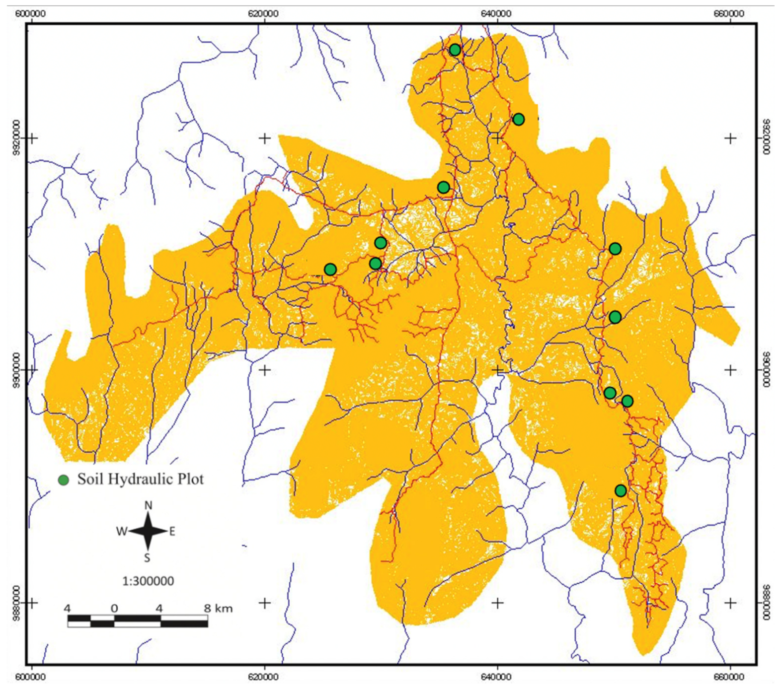
The study site is located in the headwater region of the Katingan watershed, one of the largest in Central Kalimantan, Indonesia. The site is in the Sari Bumi Kusuma (SBK) concession area, a private forest company (00°36′–01°10′ S, 111°39′–112°25′ E) located in the lowland part of Bukit Baka hills. This location is part of a high-biodiversity area known as the “Heart of Borneo.”
The mean annual rainfall from 2001 to 2012 was 3631 mm, with the highest average monthly precipitation (353 mm) occurring in November. The lowest average monthly precipitation (209 mm) was recorded in August [31]. According to the forest climate classification system of Schmidt and Ferguson [32], the area is a type A (very wet) tropical rainforest (monthly average rainfall > 100 mm). Because the location is between 5° N and 5° S, the study site is also classified as having an equatorial climate [33], which is generally characterized by high precipitation and high temperatures throughout the year. The soil in the region is classified as Ultisol (USDA soil taxonomy classification). This group of soils was previously called red–yellow podzolic soils. These red–yellow podzols appear to be more widely distributed in Indonesia and are a major soil in the lowland area of Kalimantan.
The soil structure is dominated by angular blocky material and the soil texture is dominated by silty clays, which contain 40% or more clay and 40% or more silt. The soil bulk density in the virgin forest is 0.636 g cm. Manual land clearing in the line-planted and cleared areas has increased soil bulk density by 23–32%; this has increased by 11% in the logged area and by 73% in the skidder tracks of mechanized logging. Ten years after plantation, the values in the line-planted, cleared, and logged areas recovered to levels similar to that of virgin forest, but that for skidder-track areas was still 52% higher than that in virgin forest [34].
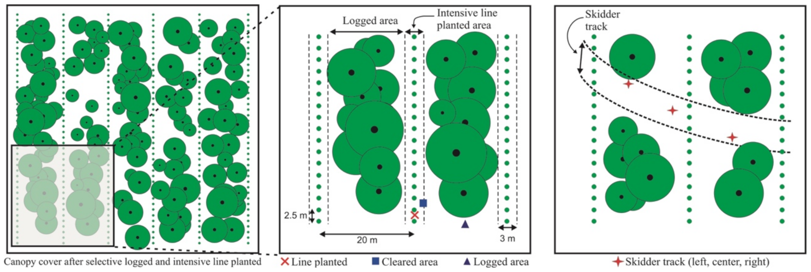
The Intensive Forest Management System (IFMS) is a new forest management system for tropical Indonesian forests. The main activities are timber harvesting using a selective logging method and forest rehabilitation with intensive line planting. A stricter cutting regime coupled with several additional selective logging controls is imposed to minimize the impact of logging on skid trails. This includes the alignment of skid trails along the contour, construction of cross-drains at 45–60° along the skid trails, and skid trail deactivation at the end of the skid trail line. Furthermore, no logging is allowed within a buffer area of at least 20 m on both sides of perennial streams. The IFMS phase after selective logging is forest rehabilitation with intensive line planting. Intensive line planting involves line clearing and line rehabilitation. About 15–20% of the forest area is a clear-cut line to enrich the standing stock using an intensive strip-line planting system.
2.2. Experimental Plots
Field observations of soil hydraulic properties were conducted on 11 plots, including 1 virgin forest plot and 10 plots at different operational blocks of the IFMS, as shown in Figure 1. Field measurements of infiltration were made using a portable double-ring infiltrometer. The inner ring was 13 cm in diameter and 24 cm high, and the outer ring was 30 cm in diameter and 15 cm high. A total of 123 infiltrometer tests were performed in the 10 plots of forest operation blocks from the first year until 10 years after forest treatments began, and in the undisturbed forest (virgin forest) plot. In each plot of the IFMS, the infiltrometer test was performed at four locations with three repetitions based on differences in topography: a line-planted area, cleared area, logged area, and an area with skidder tracks, as shown in Figure 2. In the virgin forest plot, the infiltrometer test was performed at upper, middle, and lower slopes of virgin forest blocks. These test sites were selected using a random sampling method. The tests were conducted after a minimum of 2 days without rainfall [34].
Each infiltrometer was driven 10 cm into the ground by hammering a wooden platform placed on top of the device. Great care was taken to minimize soil disturbance within the inner ring. Water was added to both rings, but measurements were made only in the inner ring. The outer ring provided a buffer that reduced boundary effects caused by the cylinder and by lateral flow at the bottom of the ring. A plastic sheet was placed in the inner ring. The outer ring was filled with water to 5 cm and the water level was maintained. The inner ring was filled with water to create a ponding depth of 5 cm for the constant head of water at the skidder track, and of 10 cm for all other sites. The plastic sheet was removed and the level of water was recorded continuously each 10 min at the skidder track and each 15 min at all other sites. Cumulative infiltration and elapsed time were recorded over a 3–4 h period to ensure that steady-state infiltrability had been attained. The infiltrability (IR) was calculated from the cumulative infiltration as a function of time [34].
2.3. Saturated Hydraulic Conductivity
Saturated hydraulic conductivity (Ks) is one of the most important hydraulic properties affecting water flow in soils. Soil type, spatial, and seasonal variability, in addition to scale dependency, are key factors that make it more difficult to accurately measure the saturated hydraulic conductivity [35,36]. Saturated hydraulic conductivity (Ks) is one of the properties of the flowpaths in almost all modes of streamflow generation [10,37]. This parameter was estimated from infiltration measurements taken in each plot, using the falling-head method [38]:
where b0 is ponded water in the soil column at t = 0, b1 is the height of ponded water at t, and L is the length of the soil column.
An additional 32 undisturbed soil samples were collected from the plots. Sampling points at the skidder track plots were selected at locations aged 1–12 years after forest treatments began and eight soil core samples were taken from the virgin forest plot at soil depths of 0–10, 10–20, 20–30, 30–40, 40–50, 90–100, 120–130, and 150 cm.
In the laboratory, a water retention test using a pressure plate was used to measure the volumetric water content, θ. Undisturbed soil core samples were placed on an aluminum tray and slowly saturated by adding water from the bottom over a 24 h period. Soil water retention curves were measured using the pressure plate method [38] for matric pressure heads (ψ) of −5, −10, −30, −60, −100, −150, −200, and −500 cm. After measuring the water content at ψ = −500 cm, the soil samples were resaturated from the bottom over a 24 h period.
Then, the Ks of each sample was measured using the falling head method [39]. The observed hydraulic data sets were analyzed using physical-based models for soil water retention and hydraulic conductivity functions using the lognormal distribution (LN) model [38]. The LN model is effective for analyzing hydraulic properties and soil water movements in connection with the soil pore-size distribution [40,41,42,43]. Based on this model, water retention and hydraulic conductivity can be expressed as:
where Se is the effective saturation; θs and θr are the saturated water content and residual water content, respectively; Ks is the saturated hydraulic conductivity; ψm is the matric potential head at an Se of 0.5, which is related to the median pore radius by the capillary pressure function; σ (dimensionless) is the standard deviation of the log-transformed pore radius and represents the width of the pore radius distribution; and Q denotes the complementary normal distribution function [40].
The relationship between hydraulic conductivity K and ψ [40] was derived by substituting Equation (2) into the pore structure model proposed by [44]:
Equations (2) and (3) produce adequate descriptions of the measured hydraulic properties of various field soils [41,42,43,45]. The LN model was used to obtain the best fit to the observed data sets. The best fit was achieved by minimizing the residual sum of squares (RSS) between the computed and measured θ and K values. To fit the water retention model to the observed water retention θ(ψ) curves, ψm and σ of the LN model were optimized by minimizing the RSS. θs was fixed at a maximum measured θ value for each soil.
2.4. Surface Runoff Generation
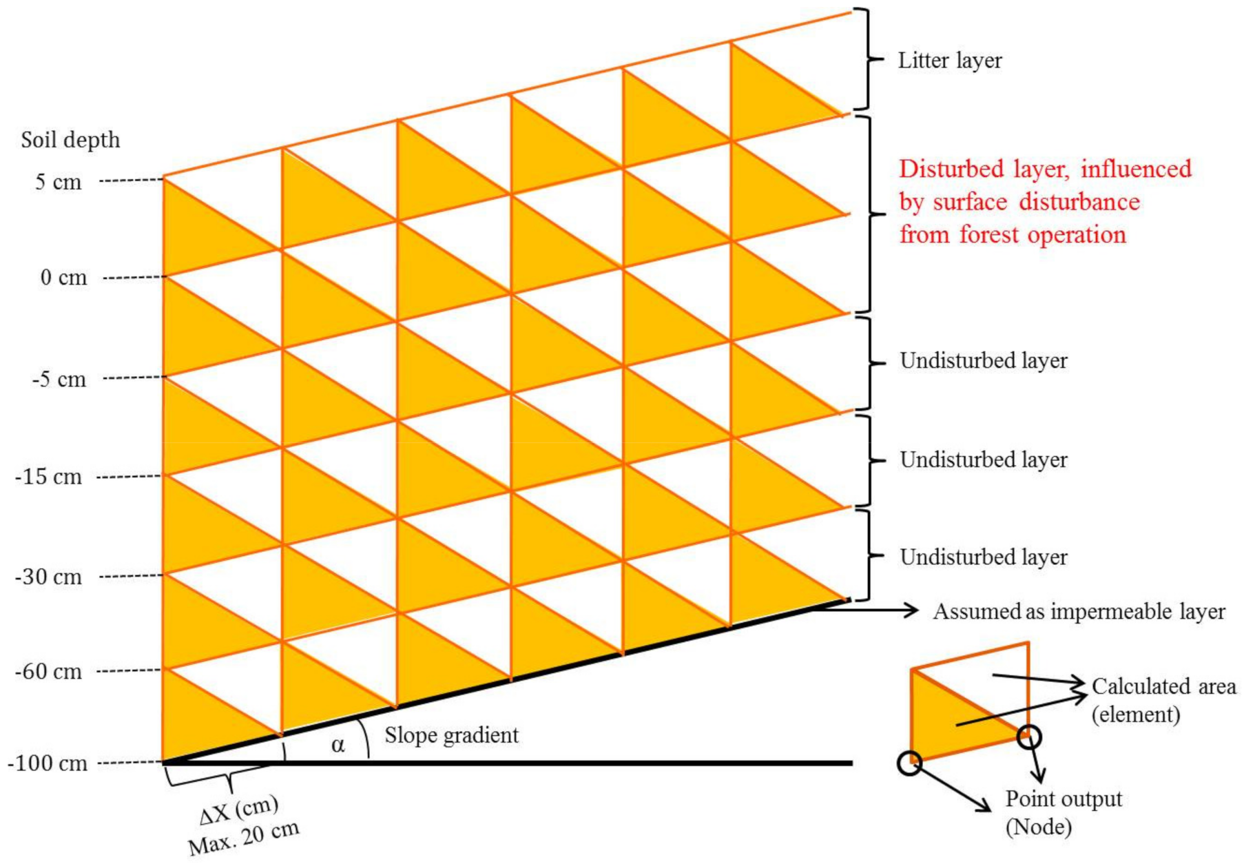
A two-dimensional saturated soil water flow simulation using the Fortran program was applied to generate surface runoff from different periods of the IFMS. We used a two-dimensional calculation domain divided by the finite element mesh. Figure 3 shows a side view of the element as the calculated area and the node as the point output of seepage discharge. Within it, unequal triangular elements were computed using topography and soil depth field data and the θ and ψ measurements. The surface interface in the region’s slope was assigned the same gradients as the average values measured in the analysis region. On the surface, downslope, and bottom boundaries, the seepage face boundary condition was imposed with different interval depths, following the soil layers.
Based on the soil profile investigation, surface soil disturbance from IFMS operations was found to have an effect at a soil depth of 0–15 cm. The scenario setting for the two-dimensional saturated soil water flow simulation model is shown in Figure 3. The soil layer depths were based on the soil profile investigation. We found no difference in the soil layers between −60 to −100 cm and −100 to −150 cm, therefore we used the soil layer of −60 to −100 cm to represent the parent material horizon. The slope gradient was given the same gradient, of 30°, as the average measured in the operational blocks. The element of the calculated area was designed with a maximum length of 20 cm for the detailed calculation at the point output (node).
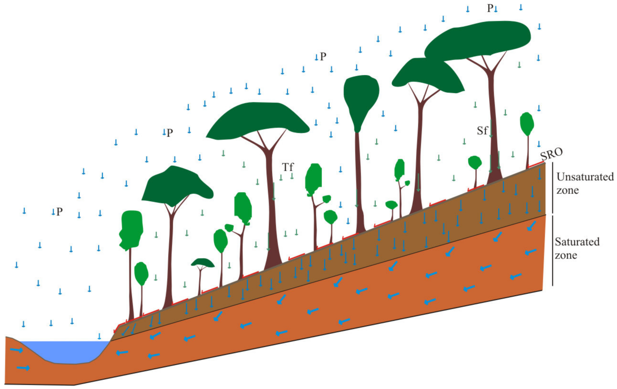
Water discharge in a forested catchment includes vertical drainage in surface soil and downslope drainage in subsurface soil (Figure 4). In vertical drainage, rainfall is supplied to the soil surface and infiltrates the soil profile unless the rainfall intensity is greater than the soil permeability. The water moves vertically in surface soil (unsaturated zone) and discharges at the bottom of the soil profile. Vertical drainage is considered to be an input into subsurface soil (saturated zone). Runoff generation was created at the edge of river channel after vertical drainage in surface soil and downslope drainage in surface soil reached their maxima.
Several parameters were established for different periods of forest operation and different types of forest treatment. The main parameters of canopy cover, net rainfall, and Ks were used in the simulations. In the present study, canopy cover density between plots was measured from a 1 ha permanent sample plot (PSP). PSP is a long-term observation site of forest growth, for measuring diameter increment, volume increment, and stand structure dynamics. In the PSP, forest vegetation is measured using a nested cover quadrats method. Each type of vegetation was measured at 25 subplots (total in 1 hectare). The subplot was classified into 20 × 20 m for trees with a diameter >20 cm (at 1.3 m above the land surface). The tree canopy cover was calculated using a conversion equation from tree diameter to canopy area for each species. Each forest operational plot and virgin forest was established with three sets of PSPs located randomly on the upper, middle, and lower slope.
3. Results and Discussion
3.1. Soil Hydraulic Conductivity
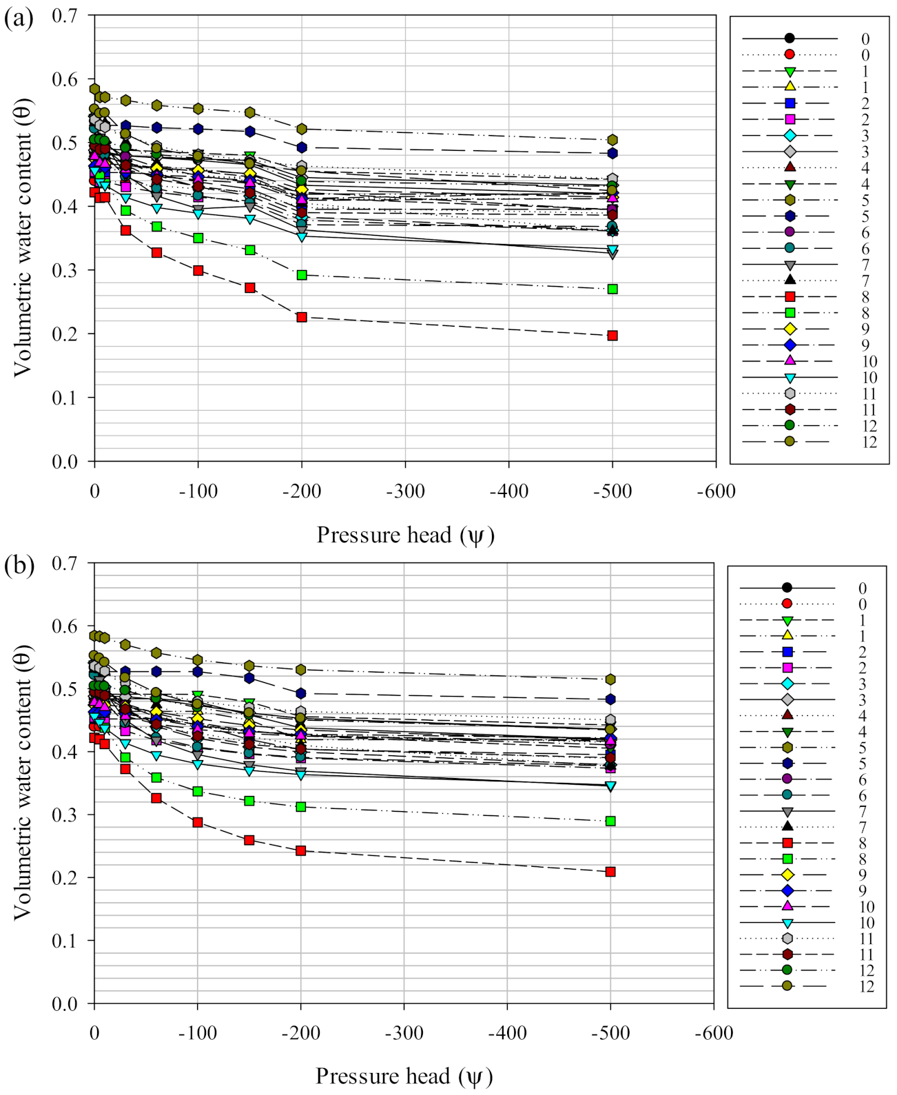
Volumetric water content and hydraulic conductivity were analyzed to assess recovery across different forest management periods. Figure 5 shows water retention θ(ψ) curves for a skidder track area during 0–12 years following treatment.
No large differences were found between observed θ(ψ) and estimated θ(ψ). Water retention curves showed large changes in the range of 0 > ψ > −60 cm. The greatest changes tended to occur in the 8 year old site, indicating a lower soil moisture content and higher soil compaction at that site. The different θ values in the skidder track may be associated with different levels of soil compaction caused by different volumes of tractor traffic.
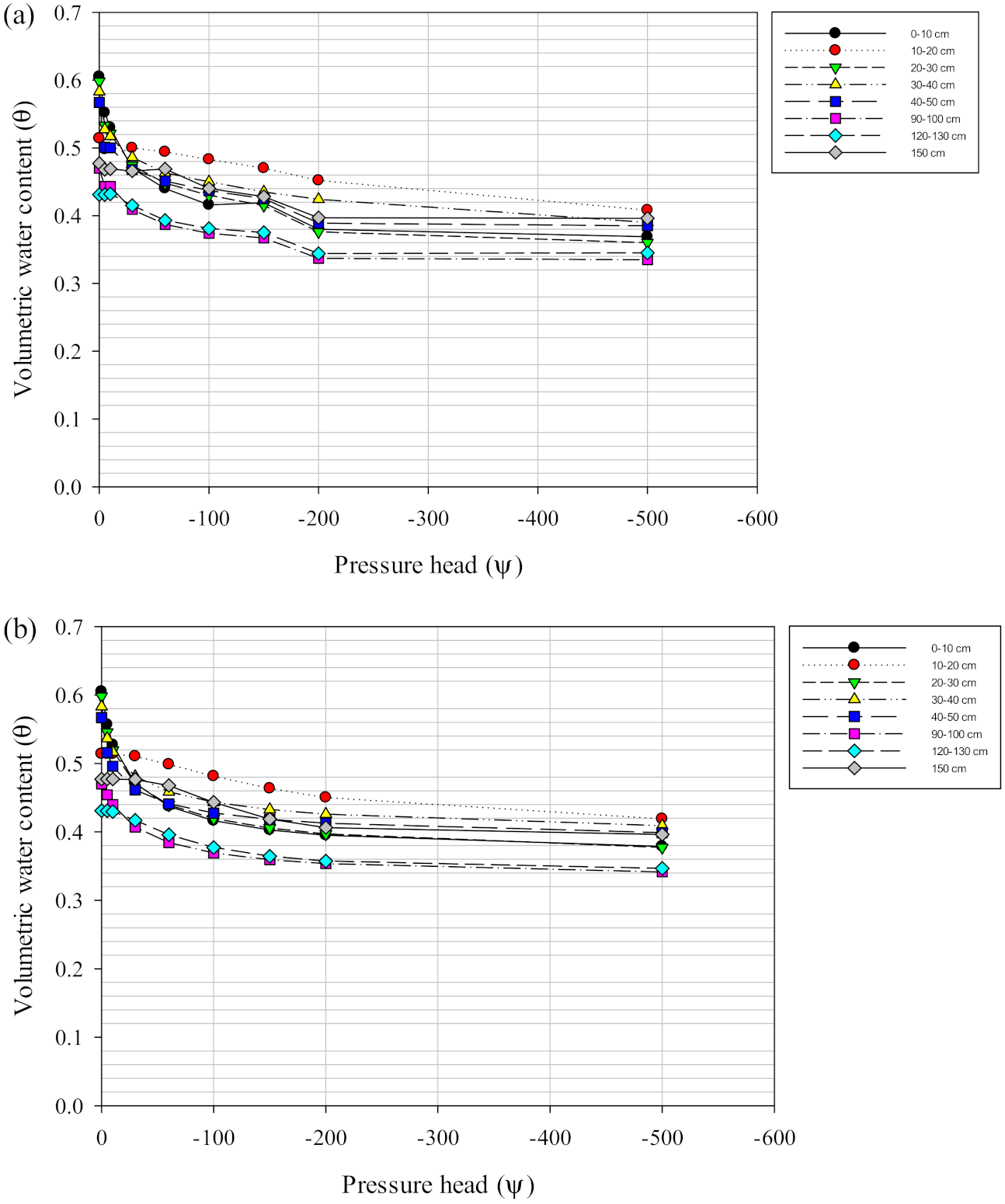
Water retention curves in the virgin forest (Figure 6) showed large changes in the range of 0 > ψ > −30 cm, indicating the existence of soil macropores. The curves for surface soils (0–50 cm deep) tended to show greater changes than subsurface soils (50–150 cm deep). In surface soil, there was intensive root growth that increased the number of macropores and the porosity.
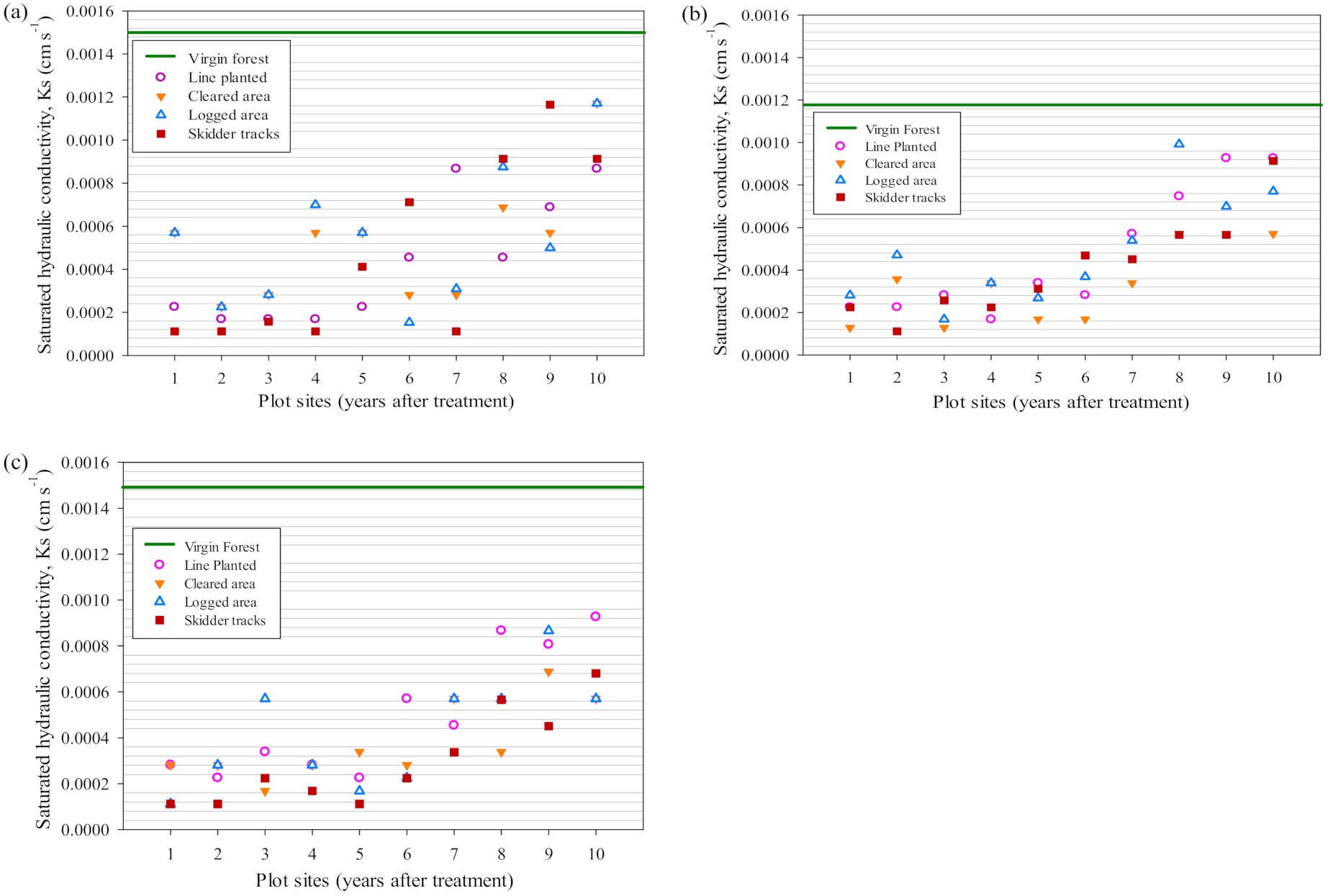
The saturated hydraulic conductivity (Ks) at different slope locations tended to increase according to site age, i.e., from the 1 year old site to the 10 year old site (Figure 7). Values were higher at upper slopes than in the middle and at lower slopes. Those in skidder tracks were lower than at other test sites, particularly in 7 to 10 year old sites. The recovery of Ks tended to take longer in skidder tracks than in other areas. In 6 to 10 year old sites, no large differences in Ks values were found between test plots. These results indicate that soil hydraulic conductivity needs at least an estimated 15 years to recover and to reach the Ks levels of a virgin forest.
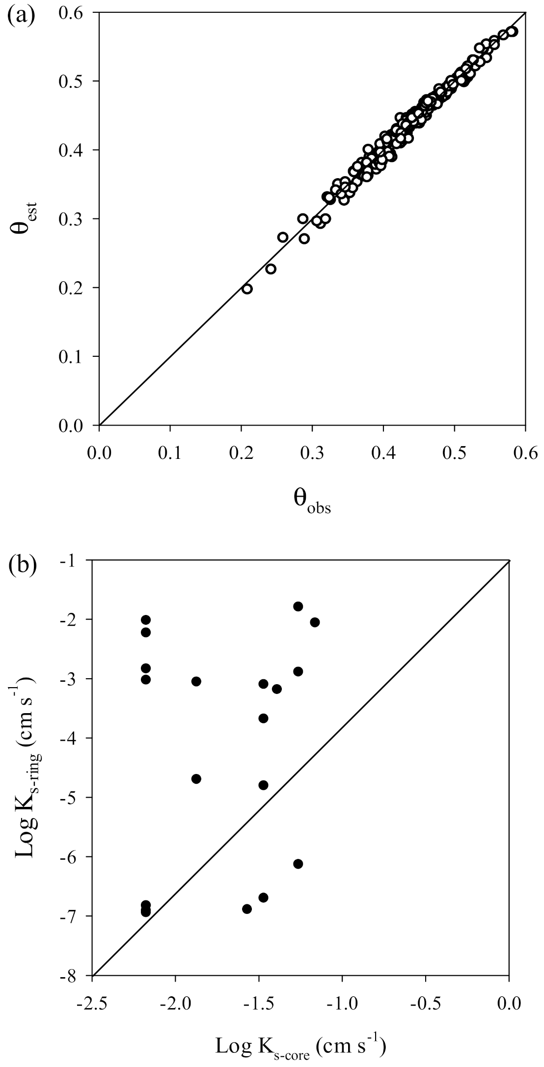
Figure 8a shows the relationship between observed and estimated θ using the LN model. There was good correspondence between observed and estimated values (data fall closely around 1:1 line), indicating that the retention model can adequately express the observed water retention curves. Figure 8b shows the relationship between Ks measured from the ring infiltrometer test (Ks-ring) and soil core samples (Ks-core). The data are widely scattered, which indicates that the results from the infiltrometer tests did not adequately correspond to the Ks values from soil core samples. This may be due to several factors, such as the different locations, sample size, time period, and the different number of samples. Direct measurements of Ks (either in the laboratory using soil core samples previously taken from the field, or directly in the field without removing a soil sample) are preferred to indirect methods (derived from soil textural characteristics). Field methods provide data that better represent the reality of water flow in natural conditions [12,35,36].
3.2. Saturated Hydraulic Conductivity to Generate Surface Runoff
The soil hydraulic properties were used to generate surface runoff (SRO) values. Measurements of saturated hydraulic conductivity (Ks) following the various surface disturbances were used to assess the influence of forest fragmentation on the near-surface hydrologic response. Forest fragmentation results in a mosaic of surfaces with distinct infiltration characteristics. Table 1 shows all of the observed Ks values at different periods and test sites of IFMS treatment. The values were lower for all test sites than for the virgin forest, further confirming that surface soil disturbances reduce the Ks value. The soil hydraulic properties shown in Table 1 were used to estimate surface runoff flow as designed in Figure 3.
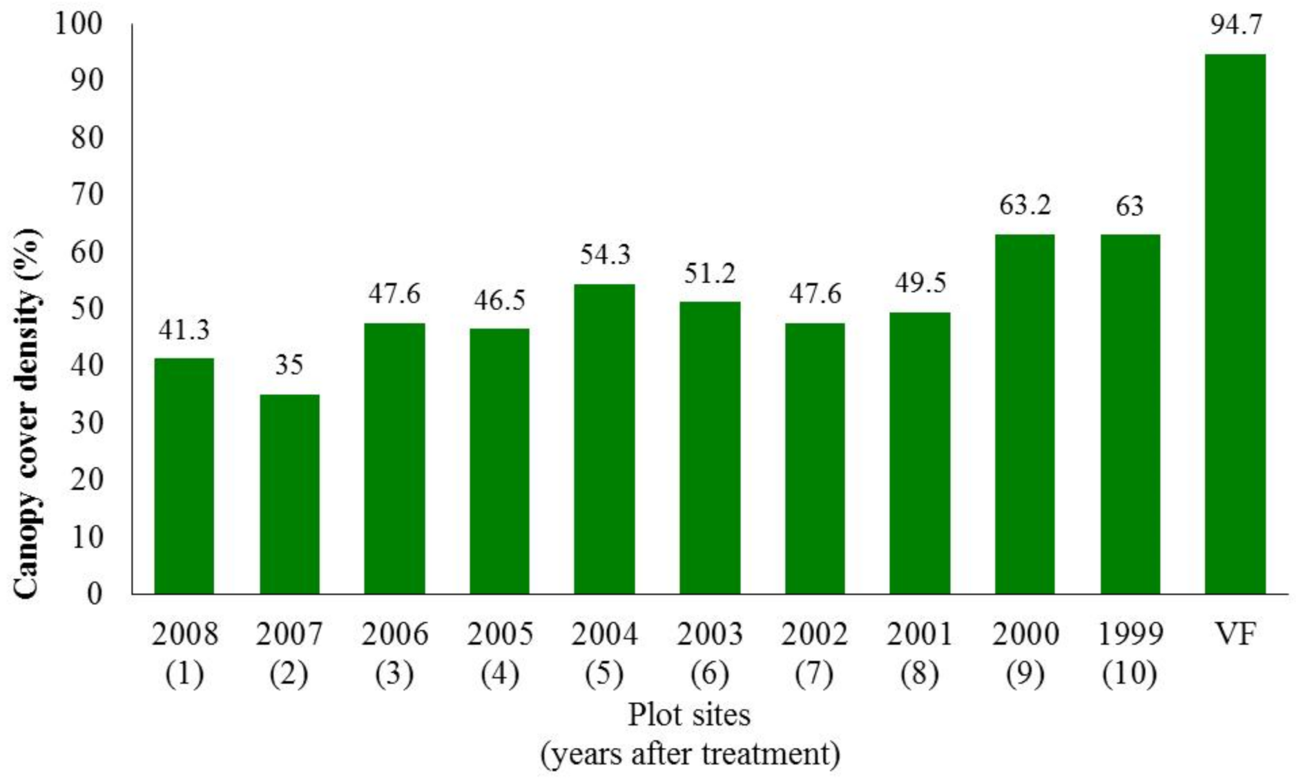
Different degrees of canopy cover lead to different levels of canopy interception. The average canopy cover density between plots is shown in Figure 9.
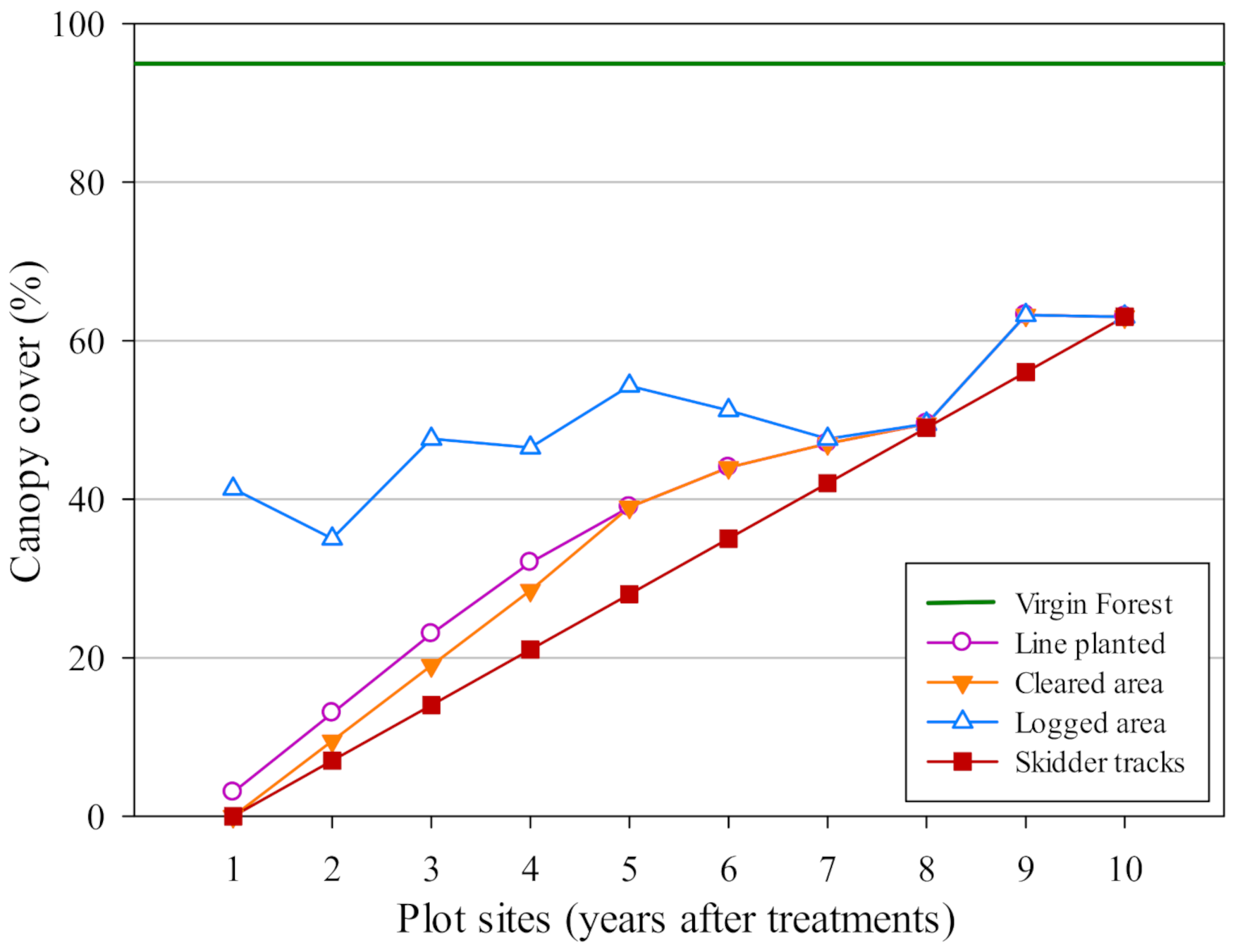
Forest operation in the IFMS sites reduced the canopy cover density, which increased with time. Canopy cover density influences the net rainfall that reaches the forest floor. To determine the variation in net rainfall between plots under the different treatments (line-planted, cleared, logged, and skidder-tracked areas), an assumption was developed, as shown in Figure 10.
Figure 10 was developed based on the PSP measurements and field observations. The canopy covers for line-planted, cleared, and skidder-tracked areas were assumed to be similar to those of logged areas in the 8 to 10 year old sites. In the 5 to 7 year old sites, the canopy cover in cleared areas was assumed to be similar to that of line-planted areas. The data on the canopy cover of line-planted areas, when plotted on a graph, followed a curved line that was assumed to represent a vegetation growth curve. In 1 to 4 year-old sites, there were different canopy covers between line-planted and cleared areas, with line-planted areas having more canopy cover than cleared areas that had 1–4 years of succession. No vegetation was planted on skidder tracks; thus, the canopy cover on skidder tracks was affected by the surrounding vegetation. Therefore, the canopy cover on skidder tracks in 1 to 10 year old sites was assumed to occur in straight line.
3.3. Effectiveness of a River Buffer on Surface Runoff Flow
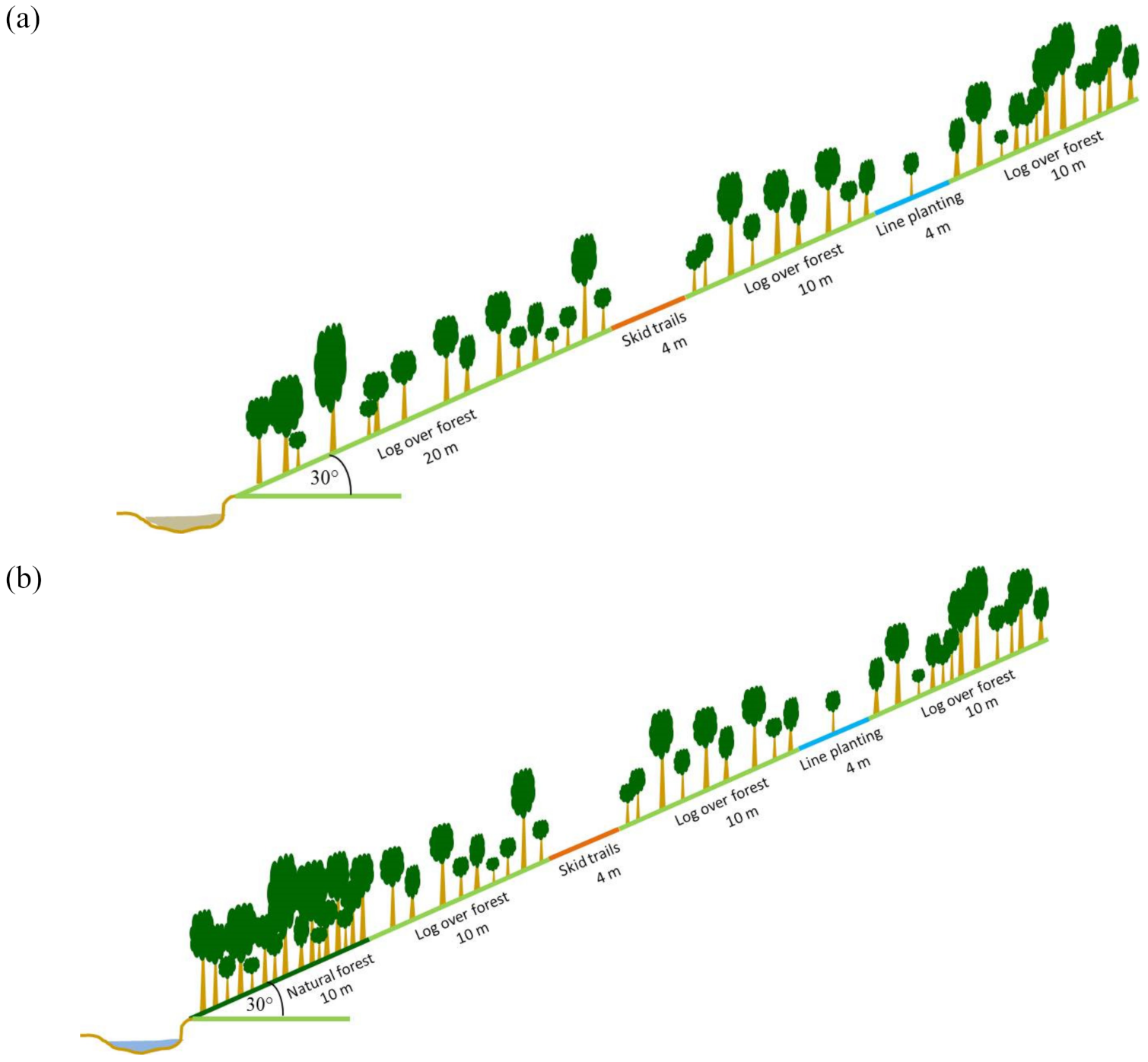
A river buffer is used to reduce the impact of logging on runoff and erosion. This simulation combined a buffer area with each treatment area, as shown in Figure 11. The slope gradient was assumed to be 30°, based on the average slope gradient in the study sites.
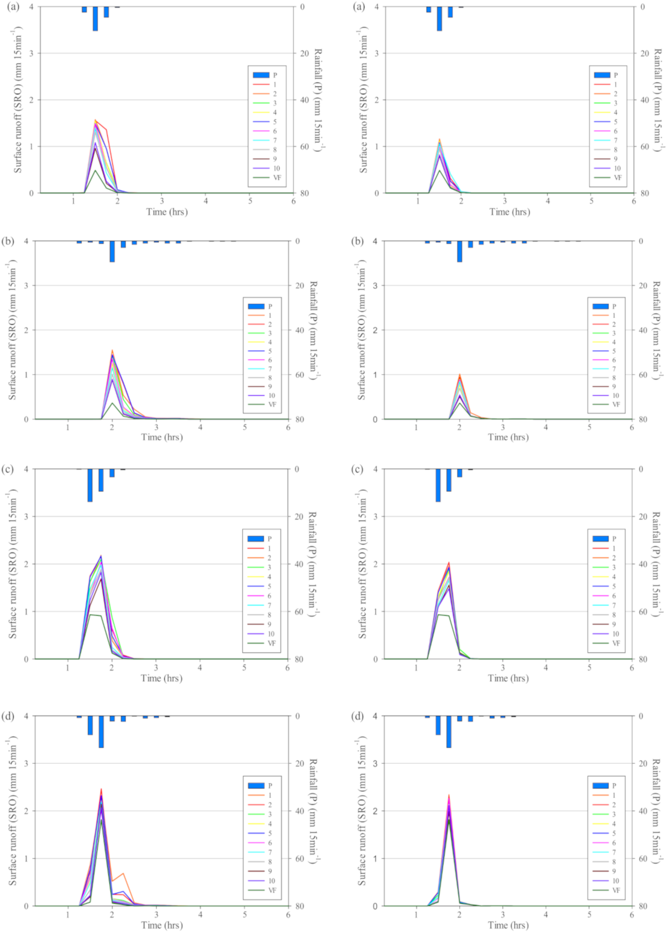
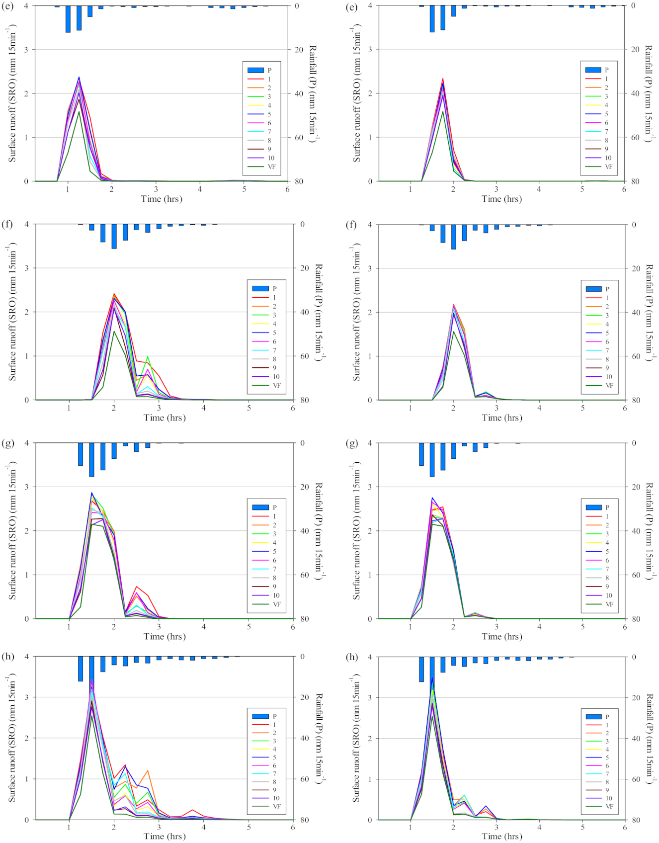
Several rainfall events were used to generate the surface runoff hydrograph in the scenario without a river buffer (left) and with a river buffer (right) shown in Figure 12.
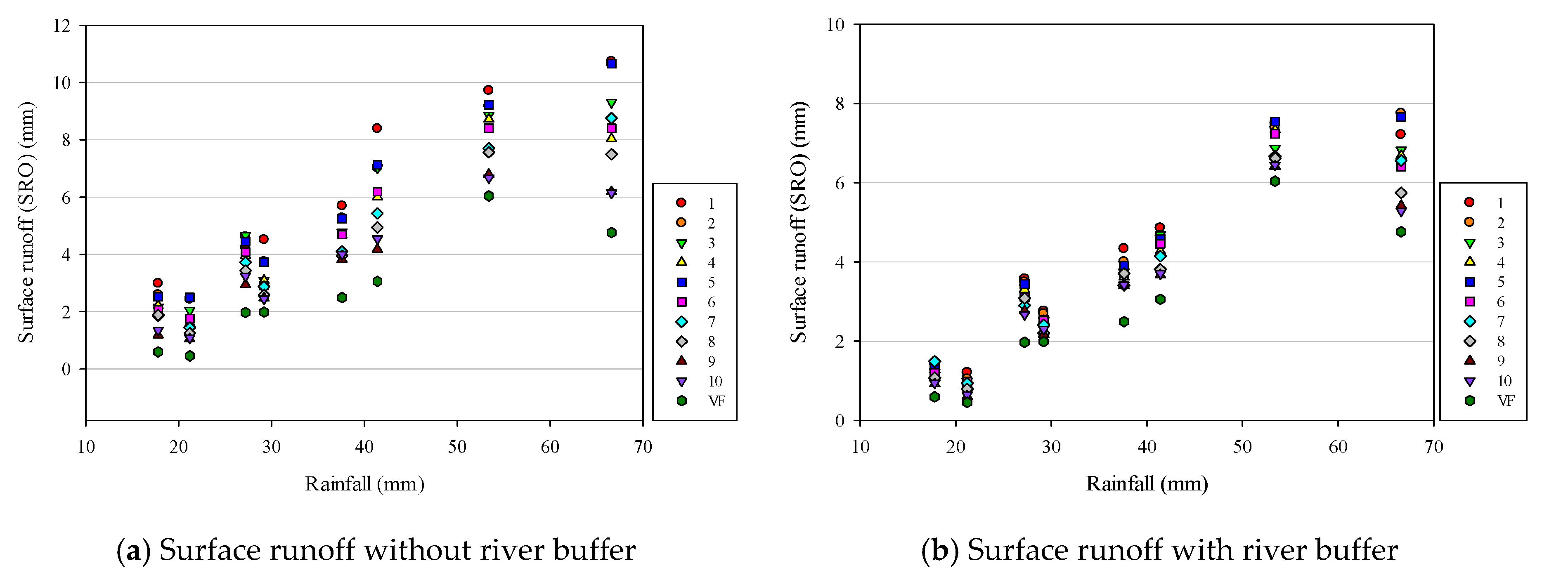
The SRO hydrograph indicates that there was a significant difference between plots during rainfall events (Figure 12). A dramatic difference was apparent between the virgin forest (VF) site and 1 year old site. Ten years after logging operations were ceased and vegetation was allowed to recover, differences were still found in the hydrograph between the VF site and 10 year old site. This difference indicates that surface disturbances at the 10 year old site continued to affect the hydraulic properties of the forest soil at the time of this study. Figure 13 shows the relationship between rainfall and total SRO.
Figure 13 show the data on SRO at all sites during different rainfall events. IFMS treatment changed the vertical drainage in surface soil. This indicates that forest interception (include canopy interception and forest floor interception) in the VF site contributed to reducing the peak discharge (Qp) in Figure 12. In the VF site, the average canopy interception was 23.8% of rainfall and the average forest interception was 91.7% [46].
Figure 13 shows clear differences in the surface runoff hydrograph between scenarios without and with the use of a buffer. The difference between the VF site and the 10 year old site were slightly smaller than that in the scenario without a buffer area. This indicates that the buffer area has significant influence in reducing the SRO hydrograph in the disturbed sites. To clarify the differences between the scenario with and without a buffer area, the coefficients of Qp and SRO are shown in Figure 14.
Soil hydrologic properties at the disturbed sites were changed and produced higher Qp and SRO coefficients, compared to the VF site (Figure 14). However, the Qp and SRO coefficients declined at disturbed sites over time, indicating that soil hydraulic properties slowly recovered. A smaller Qp coefficient indicates a greater potential for a forested catchment to reduce Qp (Figure 14a). In the early years after IFMS treatment, large gaps in Qp and SRO were found between the scenarios with and without buffer areas. The buffer area can effectively reduce the Qp and SRO coefficients, which declined at each site over time. The buffer area canopy serves as a barrier against precipitation reaching the ground. The high canopy cover density in the buffer area controlled the net precipitation via canopy interception. The treated area had less canopy cover, compacted soils, and low infiltration capacities. Consequently, these conditions reduced the forest interception, evapotranspiration, and infiltration volumes, creating a quick surface runoff response and increasing the percentage of rainfall to surface runoff in the model. Undisturbed soil hydraulic properties played a major role in the high infiltration capacity. The combination between high canopy interception and high infiltration capacity in the buffer area had a significant role in the SRO reduction that occurred in the early period following treatment (Figure 14b). Ten years following the initiation of the IFMS, the SRO coefficient of the disturbed sites was reduced and was similar to that of the VF site. These results suggest that the disturbed sites need at least 15 years to recover their soil hydraulic properties to levels similar to those at the VF site.
4. Conclusions
Forest disturbance affects soil hydraulic properties, and therefore results in differences in the propensity to generate surface runoff flow in different types of forested sites. The current study showed that soil compaction changed the soil pore distribution and affected soil moisture characteristics. In natural conditions, water retention curves for surface soils (0–50 cm deep) tended to display greater changes in θ than subsurface soils (50–150 cm deep). Intensive root growth at depths of 0–50 cm was effective for increasing the number of macro-pores and the porosity. Low surface Ks values were found on skidder tracks compared to other surface disturbance types. Consolidated surfaces, such as skidder tracks, line-planted areas, cleared areas, and logged areas, contribute disproportionately to the stormflow response because low Ks values (compared to natural conditions) lead to surface runoff for low rainfall intensities. Forest disturbances have altered the typical surface hydrological pathways, thereby creating the conditions for more surface runoff on disturbed surfaces than on undisturbed surfaces. The recovery time for near-surface Ks on non-skidder tracks was estimated to be between 10 and 15 years, whereas in the skidder tracks it was estimated to be more than 20 years. Maintaining the buffer area can effectively reduce the Qp and SRO values in the stream channel.
Author Contributions
Conceptualization, H.S. and K.K.; methodology, H.S. and K.K.; Modelling software, K.K.; Validation, H.S., K.K.; formal analysis, H.S.; investigation, H.S. Both authors have read and agreed to the published version of the manuscript.
Funding
This research received no external funding.
Institutional Review Board Statement
Not applicable.
Informed Consent Statement
Not applicable.
Data Availability Statement
This study did not report any data.
Conflicts of Interest
The authors declare no conflict of interest.
References
- Bruijnzeel, L.A. Hydrology of moist tropical forest and effects of conversion: A state knowledge review. In Hydrology of Moist Tropical Forests and Effects of Conversion: A State of Knowledge Review; UNESCO: Paris, France; Vrije Universiteit: Amsterdam, The Netherlands, 1990. [Google Scholar]
- Beshta, R.L.; Pyles, M.R.; Skaugset, A.E.; Surfleet, C.G. Peakflow responses to forest practices in the western cascades of Oregon, USA. J. Hydrol. 2000, 233, 102–120. [Google Scholar] [CrossRef] [Green Version]
- Bruijnzeel, L.A. Hydrological functions of tropical forests: Not seeing the soil for the tree? Agric. Ecosyst. Environ. 2004, 104, 185–228. [Google Scholar] [CrossRef]
- Ziegler, A.D.; Negishi, J.N.; Sidle, R.C.; Noguchi, S.; Abdul Rahim, N. Impact of logging disturbance on hillslope saturated hydraulic conductivity in a tropical forest in Peninsular Malaysia. Catena 2006, 67, 89–104. [Google Scholar] [CrossRef]
- Suryatmojo, H.; Fujimoto, M.; Yamakawa, Y.; Kosugi, K.; Mizuyama, T. Runoff and soil erosion characteristics in different periods of an intensive forest management system in a tropical Indonesian rainforest. Int. J. Sustain. Dev. Plan. 2014, 9, 830–846. [Google Scholar] [CrossRef] [Green Version]
- Van Der Plas, M.C.; Bruijnzeel, L.A. Impact of Mechanized Selective Logging of Rainforest on Topsoil Infiltrability in the Upper Segama Area, Sabah, Malaysia. Hydrol. Warm Humid Regions IAHS Publ. 1993, 216, 203–211. [Google Scholar]
- Malmer, A. Hydrological effects and nutrient losses of forest plantation establishment on tropical rainforest land in Sabah, Malaysia. J. Hydrol. 1996, 174, 129–148. [Google Scholar] [CrossRef]
- Noguchi, S.; Abdul Rahim, N.; Yusop, Z.; Tani, M.; Toshiaki, S. Rainfall-runoff responses and roles of soil moisture variations to the response in Tropical Rain Forst, Bukit Tarek, Peninsular Malaysia. J. For. Res. 1997, 2, 125–132. [Google Scholar] [CrossRef]
- Williamson, J.R.; Neilsen, W.A. The influence of forest site on rate and extent of soil compaction and profile disturbance of skid trails during ground-based harvesting. Can. J. For. Res. 2000, 30, 1196–1205. [Google Scholar] [CrossRef]
- Ziegler, A.D.; Giambelluca, T.W.; Tran, L.T.; Vana, T.T.; Nullet, M.A.; Fox, J.; Pinthong, J.; Maxwell, J.F.; Evett, S. Hydrological consequences of landscape fragmentation in mountainous northern Vietnam: Evidence of accelerated surface runoff flow generation. J. Hydrol. 2004, 287, 124–146. [Google Scholar] [CrossRef]
- Zimmermann, B.; Elsenbeer, H.; De Moraes, J.M. The influence of land-use changes on soil hydraulic properties: Implications for runoff generation. For. Ecol. Manag. 2005, 222, 29–38. [Google Scholar] [CrossRef]
- Kosugi, K.I.; Uchida, T.; Matsuda, S.; Mizuyama, T. Spatial variability of soil hydraulic properties in forested hillslope. J. For. Res. 1999, 4, 107–114. [Google Scholar]
- Ziegler, A.D.; Giambelluca, T.W.; Plondke, D.; Leisz, S.; Tran, L.T.; Fox, J.; Nullet, M.A.; Vogler, J.B.; Troung, D.M.; Vien, T.D. Hydrological consequences of landscape fragmentation in mountainous nortern Vietnam: Buffering of Hortonian surface runoff flow. J. Hydrol. 2007, 337, 52–67. [Google Scholar] [CrossRef]
- Osuji, G.E.; Okon, M.A.; Chukwuma, M.C.; Nwarie, I.I. Infiltration Characteristics of Soils under Selected Land Use Practices in Owerri, Southeastern Nigeria. World J. Agric. Sci. 2010, 6, 322–326. [Google Scholar]
- Hassler, S.K.; Zimmermann, B.; Breugel, M.; Hall, J.S.; Elsenbeer, H. Recovery of saturated hydraulic conductivity under secondary succession on former pasture in the humid tropics. For. Ecol. Manag. 2011, 261, 1634–1642. [Google Scholar] [CrossRef]
- Zimmermann, A.; Schinn, D.S.; Francke, T.; Elsenbeer, H.; Zimmermann, B. Uncovering patterns of near surface saturated hydraulic conductivity in an overland flow-controlled landscape. Geoderma 2013, 195–196, 1–11. [Google Scholar] [CrossRef]
- Liang, W.-L.; Kosugi, K.; Mizuyama, T. Heterogeneous soil water dynamics around a tree growing on a steep hillslope. Vadose Zone J. 2007, 6, 879–889. [Google Scholar] [CrossRef]
- Nussbaum, R.; Hoe, A.L. Rehabilitation of Degraded Sites in Logged-Over Forest Using Dipterocarps. In Dipterocarps Forest Ecosystem. Towards Sustainable Management; Schulte, A., Schone, D., Eds.; World Publishing: Singapore, 1996; pp. 446–463. [Google Scholar]
- Nussbaum, R.; Anderson, J.; Spencer, T. Planting Dipterocarps for Rehabilitation of Log Landings and Skid Trails in Sabah, Malaysia. In Proceedings of the Fifth Round-Table Conference on Dipterocarps, Chiang Mai, Thailand, 7–10 November 1994; Appanah, S., Khoo, K.C., Eds.; Forest Research Institute Malaysia: Kuala Lumpur, Malaysia, 1994; pp. 299–315. [Google Scholar]
- Adam, K.L.; Bruijnzeel, L.A. Managing Tropical Forest Watersheds for Production: Where contra-dictionary theory and practice co-exist. In Wise Management of Tropical Forests; Oxford Forestry Institute: Oxford, UK, 1992; pp. 37–75. [Google Scholar]
- Bruijnzeel, L.A.; Chritchley, W.R. Environmental impacts of logging moist tropical forests. In International Hydrology Programme, Series 7; UNESCO: Paris, France, 1994. [Google Scholar]
- Ziegler, A.D.; Giambelluca, T.W. Importance of rural roads as source areas for runoff in mountainous areas of northern Thailand. J. Hydrol. 1997, 196, 204–229. [Google Scholar] [CrossRef]
- Wemple, B.C.; Swanson, F.J.; Jones, J.A. Forest roads and geomorphic process interactions, Cascade Range, Oregon. Earth Surf. Proc. Landf. 2001, 26, 191–204. [Google Scholar] [CrossRef]
- Chappell, N.A.; Douglas, I.; Hanapi, J.M.; Tych, W. Sources of suspended sediment within tropical catchment recovering from selective logging. Hydrol. Process. 2004, 18, 685–701. [Google Scholar] [CrossRef]
- Gholzom, E.H.; Gholami, V. A Comparison between Natural Forests and Reforested Lands in Terms of Runoff Generation Potential and Hydrologic Response (Case Study: Kasilian Watershed). Soil Water Res. 2012, 4, 166–173. [Google Scholar] [CrossRef]
- Schnorbus, M.; Alila, Y. Peak flow regime changes following forest harvesting in a snow-dominated basin: Effects of harvest area, elevation, and channel connectivity. Water Resour. Res. 2013, 49, 517–535. [Google Scholar] [CrossRef] [Green Version]
- Chandler, K.R.; Stevens, C.J.; Binley, A.; Keith, A.M. Influence of tree species and forest land use on soil hydraulic conductivity and implications for surface runoff generation. Geoderma 2018, 310, 120–127. [Google Scholar] [CrossRef] [Green Version]
- Hao, M.; Zhang, J.; Meng, M.; Chen, H.Y.; Guo, X.; Liu, S.; Ye, L. Impacts of changes in vegetation on saturated hydraulic con- ductivity of soil in subtropical forests. Sci. Rep. 2019, 9, 1–9. [Google Scholar]
- Zhao, M.; Boll, J.; Brooks, E.S. Evaluating the effects of timber harvest on hydrologically sensitive areas and hydrologic response. J. Hydrol. 2020, 593, 125805. [Google Scholar] [CrossRef]
- Fashi, F.H.; Gorji, M.; Shorafa, M. Estimation of soil hydraulic parameters for different land-uses. Model. Earth Syst. Environ. 2016, 2, 1–7. [Google Scholar] [CrossRef] [Green Version]
- Suryatmojo, H.; Fujimoto, M.; Yamakawa, Y.; Kosugi, K.; Mizuyama, T. Water balance changes in the tropical rainforest with intensive forest management system. Int. J. Sustain. Future Hum. Secur. J.-SustaiN 2013, 1, 56–62. [Google Scholar] [CrossRef]
- Schmidt, F.H.; Ferguson, J.H.A. Rainfall types based on wet and dry period ratios for Indonesia with Western New Guinea. 1951. Available online: https://agris.fao.org/agris-search/search.do?recordID=US201300720509 (accessed on 21 November 2020).
- Tan, K.H. Soils in the Humid Tropics and Monsoon Region of Indonesia; CRC Press, Taylor and Francis Group: Boca Raton, FL, USA, 2008; pp. 77–90. [Google Scholar]
- Suryatmojo, H. Recovery of Forest Soil Disturbance in the Intensive Forest Management System. Procedia Environ. Sci. 2014, 20, 832–840. [Google Scholar] [CrossRef] [Green Version]
- Fodor, N.; Sandor, R.; Orfanus, T.; Lichner, L.; Rajkai, K. Evaluation method dependency of measured saturated hydraulic conductivity. Geoderma 2011, 165, 60–68. [Google Scholar] [CrossRef]
- Reynolds, W.D.; Bowman, B.T.; Brunke, R.R.; Drudy, C.F.; Tan, C.S. Comparison of Tensio Infiltrometer, Pressure Infiltrometer, and Soil Core Estimates of Saturated Hydraulic Conductivity. J. Soil Sci. Soc. 2000, 64, 478–484. [Google Scholar] [CrossRef]
- Elsenbeer, H. Hydrologic flowpaths in tropical rainforest soilscapes: A review. Hydrol. Proces. 2001, 15, 1751–1759. [Google Scholar] [CrossRef]
- Jury, W.A.; Gardner, W.R.; Gardner, W.H. Soil Physics, 5th ed.; John Wiley & Sons, Inc.: Hoboken, NJ, USA, 1991; pp. 77–87. [Google Scholar]
- Kluten, A.; Dirksen, C. Hydraulic conductivity and diffusivity: Laboratory methods. In Methods of Soil Analysis, Part. 1: Physical and Meneralogical Methods, Monograph No. 9; Klute, A., Ed.; American Society of Agronomy: Madison, WI, USA, 1986. [Google Scholar]
- Kosugi, K. Lognormal distribution model for unsaturated soil hydraulic properties. Water Resour. Res. 1996, 32, 2697–2703. [Google Scholar] [CrossRef]
- Kosugi, K. A new model to analyse water retention characteristics of forest soils based on soil pore radius distribution. J. For. Res. 1997, 2, 1–8. [Google Scholar] [CrossRef]
- Kosugi, K. New diagrams to evaluate soil pore radius distribution and saturated hydraulic conductivity of forest soil. J. For. Res. 1997, 2, 95–101. [Google Scholar] [CrossRef]
- Kosugi, K. Effect of pore radius distribution of forest soils on vertical water movement in soil profile. J. Jpn. Soc. Hydrol. Water Resour. 1997, 10, 226–237. [Google Scholar] [CrossRef]
- Mualem, Y. A new model for predicting the hydraulic conductivity of unsaturated porous media. Water Resour. Res. 1976, 12, 513–522. [Google Scholar] [CrossRef] [Green Version]
- Kosugi, K.; Mori, K.; Yasuda, H. An inverse modelling approach for characterization of unsaturated water flow in an organic forest floor. J. Hydrol. 2001, 246, 96–108. [Google Scholar] [CrossRef]
- Suryatmojo, H.; Fujimoto, M.; Kosugi, K.; Mizuyama, T. Effects of Selective Logging Methods on Runoff Characteristics in Paired Small Headwater Catchment. Procedia Environ. Sci. 2013, 17, 221–229. [Google Scholar] [CrossRef] [Green Version]
Figure 1.
Location of the experimental plots for soil hydraulic properties.

Figure 2.
Infiltrometer test sites in line-planted, cleared, logged, and skidder-track areas.

Figure 3.
Scenario setting for two-dimensional saturated soil water flow simulation model.

Figure 4.
The process of water discharge in a forested catchment. (P = precipitation; Tf = throughfall; Sf = stemflow; SRO = surface runoff).
Figure 4.
The process of water discharge in a forested catchment. (P = precipitation; Tf = throughfall; Sf = stemflow; SRO = surface runoff).

Figure 5.
Water retention θ(ψ) curves for a skidder track area 0–12 years after IFMS treatment. (a) Observed θ(ψ). (b) Estimated θ(ψ).
Figure 5.
Water retention θ(ψ) curves for a skidder track area 0–12 years after IFMS treatment. (a) Observed θ(ψ). (b) Estimated θ(ψ).

Figure 6.
Water retention θ(ψ) curves in the virgin forest at different soil depths. (a) Observed θ(ψ). (b) Estimated θ(ψ).
Figure 6.
Water retention θ(ψ) curves in the virgin forest at different soil depths. (a) Observed θ(ψ). (b) Estimated θ(ψ).

Figure 7.
Saturated hydraulic conductivity (Ks) at all 11 plots, calculated from infiltration measurements taken in each area. (a) Upper slope. (b) Middle Slope. (c) Lower slope.
Figure 7.
Saturated hydraulic conductivity (Ks) at all 11 plots, calculated from infiltration measurements taken in each area. (a) Upper slope. (b) Middle Slope. (c) Lower slope.

Figure 8.
(a) Relationship between observed (θobs) and estimated (θest) water content. (b) Relationship between Ks measured using ring infiltrometer tests (Ks-ring) and soil core samples (Ks-core).
Figure 8.
(a) Relationship between observed (θobs) and estimated (θest) water content. (b) Relationship between Ks measured using ring infiltrometer tests (Ks-ring) and soil core samples (Ks-core).

Figure 9.
Average canopy cover density measured in permanent sample plots at different IFMS sites and the virgin forest site.
Figure 9.
Average canopy cover density measured in permanent sample plots at different IFMS sites and the virgin forest site.

Figure 10.
Canopy cover in the plot sites at different forestry treatments.

Figure 11.
Simulation scenario of a surface runoff hydrograph in different forest operations: (a) without river buffer; (b) with river buffer.
Figure 11.
Simulation scenario of a surface runoff hydrograph in different forest operations: (a) without river buffer; (b) with river buffer.

Figure 12.
Surface runoff hydrograph generated from rainfall events of: (a) 17.8 mm, (b) 21.2 mm, (c) 27.2 mm, (d) 29.2 mm, (e) 37.6 mm, (f) 41.4 mm, (g) 53.4, and (h) 66.6 mm.
Figure 12.
Surface runoff hydrograph generated from rainfall events of: (a) 17.8 mm, (b) 21.2 mm, (c) 27.2 mm, (d) 29.2 mm, (e) 37.6 mm, (f) 41.4 mm, (g) 53.4, and (h) 66.6 mm.


Figure 13.
Relationship between rainfall and surface runoff in the different scenarios.

Figure 14.
(a) Coefficient of Qp to peak rainfall intensity. (b) Coefficient of total SRO to the amount of rainfall.
Figure 14.
(a) Coefficient of Qp to peak rainfall intensity. (b) Coefficient of total SRO to the amount of rainfall.


Table 1.
Observed soil hydraulic properties in different periods and test sites under IFMS treatment.
Table 1.
Observed soil hydraulic properties in different periods and test sites under IFMS treatment.
| Test Sites | Periods | Ks | Ψm | log (–Ψm) | θr | σ | θe |
|---|---|---|---|---|---|---|---|
| Line Planted | 1999 | 0.0009 | −41.0198 | 1.6130 | 0.3254 | 1.8264 | 0.1743 |
| 2000 | 0.0008 | −41.9226 | 1.6224 | 0.3275 | 1.8044 | 0.1722 | |
| 2001 | 0.0007 | −43.3268 | 1.6368 | 0.3308 | 1.7711 | 0.1689 | |
| 2002 | 0.0006 | −44.0213 | 1.6437 | 0.3324 | 1.7551 | 0.1673 | |
| 2003 | 0.0004 | −47.0335 | 1.6724 | 0.3389 | 1.6882 | 0.1608 | |
| 2004 | 0.0003 | −51.2237 | 1.7095 | 0.3474 | 1.6020 | 0.1523 | |
| 2005 | 0.0002 | −53.5833 | 1.7290 | 0.3519 | 1.5565 | 0.1479 | |
| 2006 | 0.0003 | −51.4185 | 1.7111 | 0.3478 | 1.5982 | 0.1519 | |
| 2007 | 0.0002 | −53.3802 | 1.7274 | 0.3515 | 1.5603 | 0.1482 | |
| 2008 | 0.0002 | −51.7840 | 1.7142 | 0.3485 | 1.5910 | 0.1512 | |
| Cleared Area | 1999 | 0.0007 | −42.6708 | 1.6301 | 0.3293 | 1.7865 | 0.1704 |
| 2000 | 0.0006 | −44.0285 | 1.6437 | 0.3324 | 1.7549 | 0.1673 | |
| 2001 | 0.0005 | −45.3997 | 1.6571 | 0.3354 | 1.7239 | 0.1643 | |
| 2002 | 0.0004 | −47.8510 | 1.6799 | 0.3406 | 1.6708 | 0.1591 | |
| 2003 | 0.0002 | −51.9810 | 1.7158 | 0.3488 | 1.5872 | 0.1509 | |
| 2004 | 0.0003 | −49.3260 | 1.6931 | 0.3437 | 1.6401 | 0.1561 | |
| 2005 | 0.0004 | −47.8510 | 1.6799 | 0.3406 | 1.6708 | 0.1591 | |
| 2006 | 0.0002 | −53.5833 | 1.7290 | 0.3519 | 1.5565 | 0.1479 | |
| 2007 | 0.0003 | −49.0211 | 1.6904 | 0.3430 | 1.6464 | 0.1567 | |
| 2008 | 0.0004 | −48.3744 | 1.6846 | 0.3417 | 1.6598 | 0.1580 | |
| Logged Area | 1999 | 0.0007 | −43.4338 | 1.6378 | 0.3311 | 1.7686 | 0.1687 |
| 2000 | 0.0007 | −42.7485 | 1.6309 | 0.3295 | 1.7847 | 0.1702 | |
| 2001 | 0.0005 | −45.1193 | 1.6544 | 0.3348 | 1.7302 | 0.1649 | |
| 2002 | 0.0005 | −45.9036 | 1.6618 | 0.3365 | 1.7128 | 0.1632 | |
| 2003 | 0.0004 | −47.6623 | 1.6782 | 0.3403 | 1.6748 | 0.1595 | |
| 2004 | 0.0003 | −50.5322 | 1.7036 | 0.3460 | 1.6157 | 0.1537 | |
| 2005 | 0.0004 | −47.0335 | 1.6724 | 0.3389 | 1.6882 | 0.1608 | |
| 2006 | 0.0003 | −48.8732 | 1.6891 | 0.3427 | 1.6494 | 0.1570 | |
| 2007 | 0.0003 | −49.8810 | 1.6979 | 0.3448 | 1.6288 | 0.1549 | |
| 2008 | 0.0002 | −52.6517 | 1.7214 | 0.3501 | 1.5742 | 0.1496 | |
| Skidder Tracks | 1999 | 0.0008 | −41.6762 | 1.6199 | 0.3270 | 1.8104 | 0.1727 |
| 2000 | 0.0007 | −43.3331 | 1.6368 | 0.3308 | 1.7710 | 0.1689 | |
| 2001 | 0.0007 | −43.3423 | 1.6369 | 0.3308 | 1.7708 | 0.1689 | |
| 2002 | 0.0003 | −51.2491 | 1.7097 | 0.3474 | 1.6015 | 0.1523 | |
| 2003 | 0.0003 | −51.2387 | 1.7096 | 0.3474 | 1.6017 | 0.1523 | |
| 2004 | 0.0001 | −59.3777 | 1.7736 | 0.3620 | 1.4528 | 0.1377 | |
| 2005 | 0.0003 | −51.2387 | 1.7096 | 0.3474 | 1.6017 | 0.1523 | |
| 2006 | 0.0004 | −47.0833 | 1.6729 | 0.3390 | 1.6871 | 0.1607 | |
| 2007 | 0.0001 | −59.3777 | 1.7736 | 0.3620 | 1.4528 | 0.1377 | |
| 2008 | 0.0001 | −56.9932 | 1.7558 | 0.3580 | 1.4942 | 0.1417 | |
| Virgin Forest | top soil | 0.0012 | −39.2047 | 1.5933 | 0.3209 | 1.8721 | 0.1788 |
| 20–30 cm | 0.0006 | −44.0910 | 1.6443 | 0.3325 | 1.7535 | 0.1672 | |
| 30–40 cm | 0.0005 | −44.9986 | 1.6532 | 0.3346 | 1.7329 | 0.1652 | |
| 40–50 cm | 0.0006 | −44.3201 | 1.6466 | 0.3331 | 1.7482 | 0.1667 | |
| 90–100 cm | 0.0008 | −41.8066 | 1.6212 | 0.3273 | 1.8072 | 0.1724 |
Publisher’s Note: MDPI stays neutral with regard to jurisdictional claims in published maps and institutional affiliations. |
© 2021 by the authors. Licensee MDPI, Basel, Switzerland. This article is an open access article distributed under the terms and conditions of the Creative Commons Attribution (CC BY) license (https://creativecommons.org/licenses/by/4.0/).
Share and Cite
MDPI and ACS Style
Suryatmojo, H.; Kosugi, K. River Buffer Effectiveness in Controlling Surface Runoff Based on Saturated Soil Hydraulic Conductivity. Water 2021, 13, 2383. https://doi.org/10.3390/w13172383
AMA Style
Suryatmojo H, Kosugi K. River Buffer Effectiveness in Controlling Surface Runoff Based on Saturated Soil Hydraulic Conductivity. Water. 2021; 13(17):2383. https://doi.org/10.3390/w13172383
Chicago/Turabian StyleSuryatmojo, Hatma, and Ken’ichirou Kosugi. 2021. "River Buffer Effectiveness in Controlling Surface Runoff Based on Saturated Soil Hydraulic Conductivity" Water 13, no. 17: 2383. https://doi.org/10.3390/w13172383
Note that from the first issue of 2016, this journal uses article numbers instead of page numbers. See further details here.