Article

Impact Assessment of Climate Change on the Near and the Far Future Streamflow in the Bocheongcheon Basin of Geumgang River, South Korea

Division of Environmental Science and Ecological Engineering, Korea University, 145 Anam-ro, Seongbuk-gu, Seoul 20841, Korea
*
Author to whom correspondence should be addressed.
Water 2021, 13(18), 2516; https://doi.org/10.3390/w13182516
Submission received: 13 August 2021 / Revised: 1 September 2021 / Accepted: 9 September 2021 / Published: 14 September 2021
(This article belongs to the Special Issue Climate Change Impact and Adaptation in Water Resources Management)

Abstract

:
Highly concentrated precipitation during the rainy season poses challenges to the South Korean water resources management in efficiently storing and redistributing water resources. Under the new climate regime, water resources management is likely to become more challenging with regards to water-related disaster risk and deterioration of water quality. To alleviate such issues by adjusting management plans, this study examined the impact of climate change on the streamflow in the Bocheongcheon basin of the Geumgang river. A globally accepted hydrologic model, the HEC-HMS model, was chosen for the simulation. By the calibration and the validation processes, the model performance was evaluated to range between “satisfactory” and “very good”. The calibrated model was then used to simulate the future streamflow over six decades from 2041 to 2100 under RCP4.5 and RCP8.5. The results indicated significant increase in the future streamflow of the study site in all months and seasons over the simulation period. Intensification of seasonal differences and fluctuations was projected under RCP 8.5, implying a challenge for water resources managers to secure stable sources of clean water and to prevent water-related disasters. The analysis of the simulation results was applied to suggest possible local adaptive water resources management policy.

1. Introduction

South Korea demonstrates a strong seasonality: 55.3% of its average annual rainfall (723.2 mm of 1307.7 mm) in the 30 year period between 1981 and 2010 was concentrated in the summer season, from June to August [1,2]. To cope with such seasonality, water resources in Korea are generally stored in reservoirs created behind dams during the rainy season and used during the dry season. However, if the reservoirs are insufficiently filled due to below average precipitation in a given rainy season, water shortages or droughts may occur in the following year [3]. In contrast, if precipitation increases compared to the average or if the rainy season is prolonged, serious flooding may occur in the downstream regions.
Such difficulties in domestic water resource management resulting from the seasonality are projected to be exacerbated under the changing climate [4,5,6,7,8,9,10]. Notably, increase in the annual rainfall (+54.28 mm/10 years) was observed in the 30 year period from 1981 to 2010 in South Korea, attributed especially to the summer rainy season accompanied by torrential rain [1]. According to the Korea Meteorological Administration, the summer rainy season in 2020 started on June 24 and ended on August 16, which was the longest rainy season on record since 1973 [11]. During this period, multiple extreme events of torrential rains (87 and 79 mm per hour in Busan and Daejeon metropolitan cities, respectively) were observed under the influence of the typhoon “rose”. According to the National Assembly Budget Office, 88.4% of the annual damage cost from natural disasters in South Korea is attributed to typhoons and heavy rains, as those observed in 2020. Thus, the mitigation of damage against such water-related natural disasters is the main target of national disaster reduction policies [12].
Several studies highlighted the insufficient and unsustainable nature of establishing future water resource management plans and disaster reduction policies based on the recorded hydrologic conditions of the recent past [13,14]. Instead, to predict the likelihood and the magnitude of natural disasters along with the impact of climate change on the availability of water resources, researchers should primarily conduct simulations of streamflow, which is likely to increase due to continuous or extreme rainfall in the future [15,16,17,18,19,20].
The Hydrologic Engineering Center’s Hydrologic Modeling System (HEC-HMS) is a commonly used watershed model to simulate streamflow or rainfall runoff processes. The HEC-HMS was used in several studies in various regions with different climatic and geographic conditions [21,22,23,24,25,26]. It was evaluated to be spatially and temporally accurate in predicting the watershed responses in event-based and continuous simulation as well as in simulating various scenarios in flood forecasting [27,28] and watershed management [29,30,31].
The objective of this study was to simulate and detect trends in the changes in future streamflow over the six decades from 2041 to 2100 under RCP4.5 and RCP8.5, using the HEC-HMS model. The model performance was proven effective by calibration and validation processes using two statistical measures of NSE and R2. Simulations were run over a 60 year period to consider the cumulative effect of continuous rainfall in simulation results rather than a single rainfall event and to reflect changes in trend over a long period. With further analysis of the results from the simulations, sustainable adaptive management strategies are suggested to cope with climate change impacts. Among various climate change responses such as introducing dam operation rules, increasing the storage, diversifying water resources by water recycling, and improving water transportability from water-rich to water-poor regions [32,33,34], site-specific measures that are more in line with the simulation results are suggested for water resources managers of the Bocheongcheon basin of the Geumgang river.

2. Materials and Methods
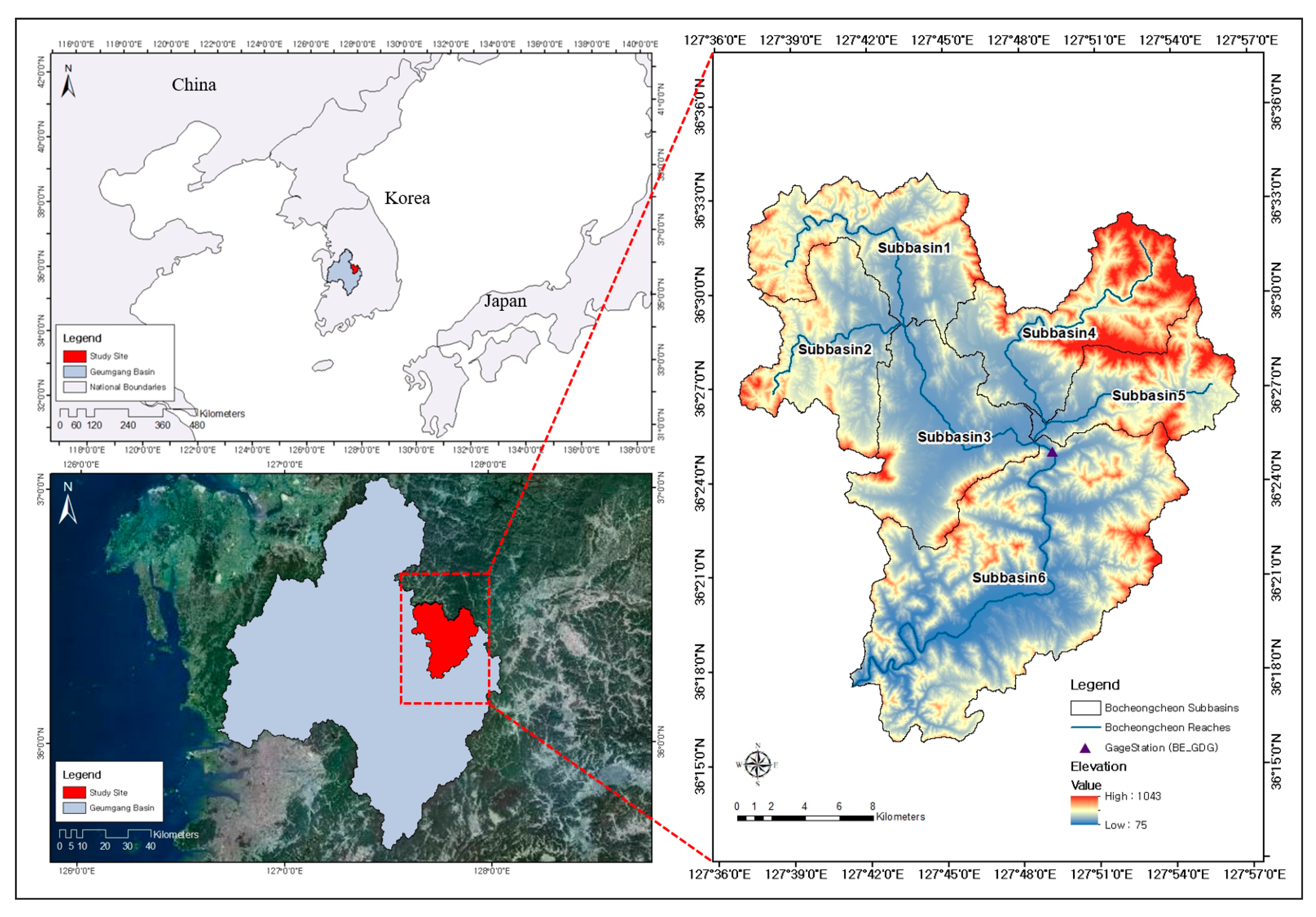
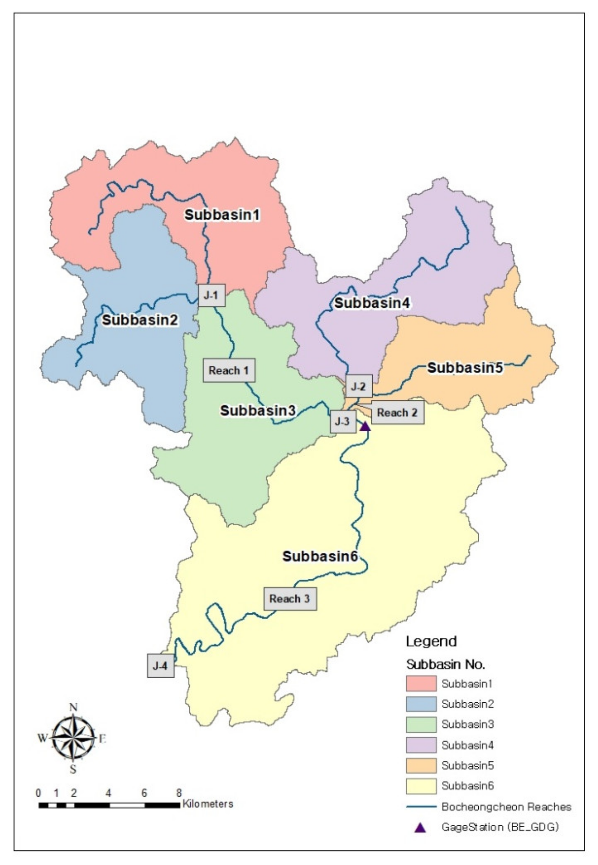
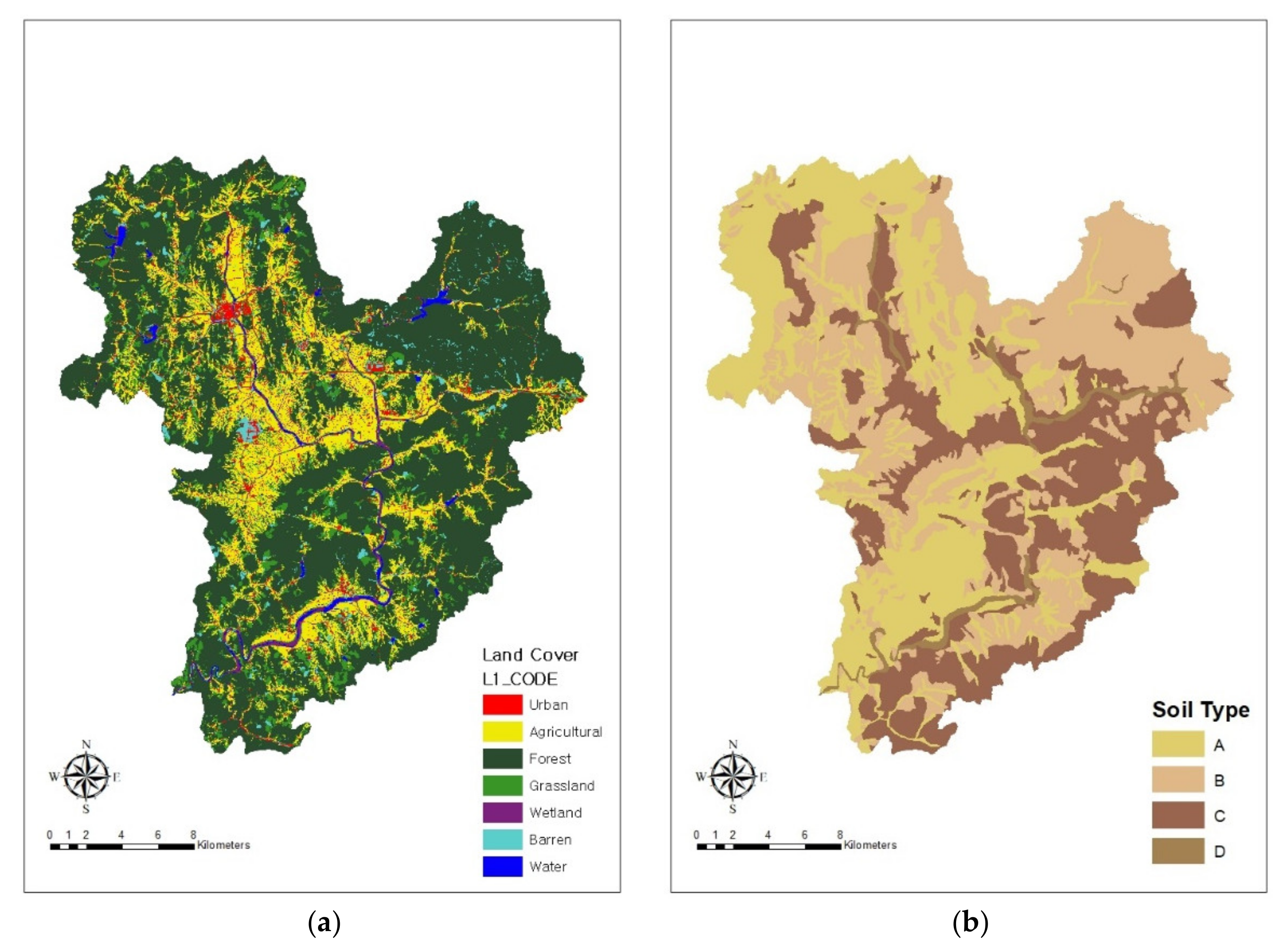
2.1. Study Area

The Bocheongcheon Basin, the target site for this study, is one of the 14 mid-sized sub-basins of the Geumgang River watershed, which is one of the four major rivers in Korea (Figure 1). The area of the Bocheongcheon basin is approximately 553.6 km2, accounting for approximately 5.6% of the total area of the Geumgang River watershed (9914 km2). The Gidaegyo gage station, which is located within the basin, recorded the average outflow of 11.31 m3/s and the maximum outflow of 308 m3/s in 2020. The basin spreads over four administrative districts: Boeun-gun, Okcheon-gun, Yeongdong-gun, and Sangju-si. Okcheon-gun was one of the most affected areas during the long rainy season in the summer of 2020, and the magnitude of damage caused by climate change is forecasted to worsen in the future [11].
This study site is also important because Daecheong Lake, located downstream of the sub-basin, constantly experiences problems with water quality due to excessive pollutants flowing in from the upstream region. As the deteriorating water quality was identified as a persisting issue to be tackled to secure a drinking water source for the nearby population [35,36], there is need for simulations of rainfall runoff in the Bocheongcheon Basin.
The simulation results of future streamflow in the Bocheongcheon Basin can serve as essential information guiding decision makers in establishing adaptive measures against the aforementioned water-related disasters and water quality issues in the nearby regions, especially the downstream sub-basins. Many past studies suggested management methods based on the simulations of the downstream regions near Daecheong Lake, where larger populations reside [16,37,38]. However, without considering the hydrologic cycle in the upstream regions, such management methods have failed to prevent those issues from reoccurring. This study aims to suggest alternative measures by analyzing the simulation results of Bocheongcheon in comparison to those of other studies that focused on the downstream regions.

2.2. HEC-HMS Model

The HEC-HMS model was developed by the U.S. Army Corps of Engineers Hydrologic Engineering Center (HEC) to simulate the complete hydrological processes of dendritic watershed systems. It provides supplementary analysis tools for model optimization and forecasting streamflow in addition to the traditional hydrologic analysis procedures, such as event infiltration, unit hydrographs, and hydrologic routing [39].
The HEC-HMS model represents a watershed with a combination of primary hydrologic elements. A sub-basin is an individual physical watershed with an outflow hydrograph at its outlet. A reach derives the outflow at the downstream end from the inflow at the upstream end. A junction is where the inflow hydrographs are combined to derive a single outflow hydrograph. A sink has inflow but no outflow. These elements are connected through the basin model, which calculates the precipitation–runoff response based on meteorological data from the meteorological model. Finally, the control specification model defines the time period and the interval of each simulation run. Each model run combined the three models (the basin model, the meteorological model, and the control specification model) to obtain the results.
In this study, the HEC-HMS Version 4.5 was used, as it provides an optimization tool. Using the optimization tool, it is possible to derive a combination of optimal parameters for any target element upstream of the observed flow location when the observed precipitation and the discharge data are available. Seven different objective functions are available to estimate the goodness-of-fit between simulated and observed discharges [39]. This optimization tool can help researchers to overcome the issue of limited data availability.
The HEC-HMS model was chosen for use in this study over many other available hydrologic models, such as PRMS (Precipitation-Runoff Modeling System), SWAT (Soil & Water Assessment Tool), ReFH (Revitalised Flood Hydrograph), and SLURP (Semi-distributed Land Use-based Runoff Processes), because of the above-mentioned functions as well as high modeling accuracy and easy-to-use GUI. The model suitability for simulation of rainfall runoff was confirmed by many existing studies [21,23,24,29].

2.3. Model Application

For the initial setup of the HEC-HMS model for the rainfall runoff simulation, the basin model was constructed by dividing the mid-sized Bocheongcheon Basin into six smaller sub-basins based on a digital elevation model (DEM) and connecting four conjunction points with three reaches, as shown in Figure 2. For the constructed basin, appropriate methods were selected for loss, direct runoff, and routing models, and the parameter values were calculated accordingly.
For the loss model to calculate the actual infiltration, we selected the Soil Conservation Service Curve Number (SCS-CN) method, which calculates the loss rate in the event of rainfall by determining the discharge based on soil cover, land use conditions, and preceding precipitation [40]. Using the 2019 Level 3 land cover map provided by the Ministry of Environment and the soil type map provided by the National Institute of Agricultural Sciences of South Korea (Figure 3), we calculated the area-weighted average SCS-CN and the percentage of impervious area for each sub-basin.
In the direct runoff model, the effective rainfall calculated in the loss model was converted into the actual surface runoff [39]. This is the most important factor in flood hydrology analysis and is used for the transformation. For the calculation of direct runoff for each sub-basin, we adopted the Clark unit hydrograph method, which is widely used in Korea [41]. It utilizes a time–area curve built into the program to develop a translation hydrograph resulting from the precipitation. It is an objective method that synthesizes a unit hydrograph based on only two parameters: the time of concentration (Tc) and the storage coefficient (Kc). Among the various equations used to calculate the two parameters for each sub-basin, we used equations 1 and 2 developed by the Seokyeong University using the domestic hydrological observation data to represent the runoff characteristics of river basins in South Korea [42].
T c = 0.339 A 0.282 L 0.318 H 0.078
K c = 1.075 L 0.472 A 0.188 T c 0.655
where Tc is the maximum travel time in the sub-basin (h), A is the sub-basin area (km2), L is the length of the flow path (km), H is the difference in altitude or the difference between the elevation of the inflow point and that of the outflow point (m), and Kc is the storage coefficient.
The Muskingum method was used to compute the outflow hydrograph from the inflow hydrograph. This method was used to determine the extent to which the magnitude of the peak flow was reduced and the time delay while passing through a section of the river. For this, Muskingum K and X are the required parameters. Muskingum K (Km) is defined as the travel time through the reach, and Muskingum X is the weighting between the inflow and the outflow influence [39].
The values of all parameters for each element were calculated by the aforementioned methods using the ArcGIS 10.5 program and later calibrated based on the daily observed discharge at the Boeun-gun Gidaegyo station for two years from 1 January 2007 to 31 December 2008 provided by the Korean Water Resources Management Information System.
For calibration, the conventional manual trial-and-error and HEC-HMS semi-automatic optimization methods were employed in parallel to achieve the optimal combination of parameters to derive values closest to those observed for outflow at the target conjunction point. Despite its time-consuming and labor-intensive nature, the trial-and-error method allows researchers to follow the physical meaning of the parameters defined in the models such that they remain within the realistic range [18]. Conversely, the semi-automatic optimization method built in the HEC-HMS model allows its model parameters to be calibrated on a series of single-flood events and selects the best-performing model parameter based on predefined algorithms [41]. With the goal of minimizing weaknesses and maximizing advantages of each method, a combined strategy of the two methods was adopted and applied to find the best possible set of parameters. Specifically, Km and X for the two reaches and SCS-CN, Tc, and Kc for all sub-basins were calibrated starting from the upstream to the downstream sub-basins.
Inserting the optimized parameters as the model input, we simulated the daily outflow at junction 3 for the year 2017 and validated it by comparing the results with the observed data. The discharge data of junction 3 was used for calibration and validation processes instead of the discharge data of junction 4. Although junction 4 is the point of final outflow of the sub-basin, it was evaluated to be less suitable due to the absence of a gage station nearby. However, the Boeun-gun Gidaegyo gage station near junction 3 could provide more precise data needed for the process. To evaluate the model accuracy, we considered Equations (3) and (4), which represent the Nash–Sutcliffe efficiency (NSE) [43] and the coefficient of determination (R2), respectively.
N S E = 1 i = 1 n O i S i 2 i = 1 n O i O ¯ 2
R 2 = i = 1 n O i O ¯ S i S ¯ i = 1 n O i O ¯ 2 i = 1 n S i S ¯ 2 2
where O is the observed value, and S is the simulated value.
The two equations were chosen as many studies evaluated them as appropriate statistical performance measures for hydrological modeling [8,42,43]. R2 is a standard regression method used to describe the degree of collinearity between observed and simulated data. NSE was evaluated to be good for use, especially with continuous long-term simulations and the determination of how well the model simulates trends for the concerned output response. This study adopted the evaluation criteria (Table 1) previously recommended for the two statistical performance measures for use in watershed- and field-scale hydrological modeling [44].
As the final step of the study, rainfall runoff was simulated for the 60 year period from 2041 to 2100 using the daily precipitation data of the MME5s to predict the impact of climate change on the future rainfall runoff. We selected MME5s (Multi-Model Ensembles version 5) among various global and regional climate models (GCMs and RCMs), as it was suggested that the findings based on one GCM or RCM provide only a small subset of possible outcomes, indicating the necessity to use an ensemble of GCMs and/or RCMs [5]. To reduce the uncertainty of each RCM and enhance the final confidence level, MME5s was created by an ensemble of five RCMs: HadGEM3-RA (the Hadley Centre Global Environment Model version 3 for the Region of Asia), RegCM4 (the Regional Climate Model system version 4), SNURCM (the Seoul National University Regional Climate Model), GRIMs (the Global/Regional Integrated Model System), and WRF (the Weather Research and Forecasting Model). It has a fine spatial resolution of 1 km and is widely used in various studies targeting South Korea [45].
This study employed climate data created under the two RCP scenarios, RCP4.5 and RCP8.5, to compare the results based on different assumptions of greenhouse gases emitted in future years. RCP8.5 is generally considered to be the basis for the worst-case high emission scenario, whereas RCP4.5 is considered to be an intermediate mitigation scenario [46]. The difference in the simulation results of the two scenarios may serve to advocate global and national emission reduction goals.

3. Results

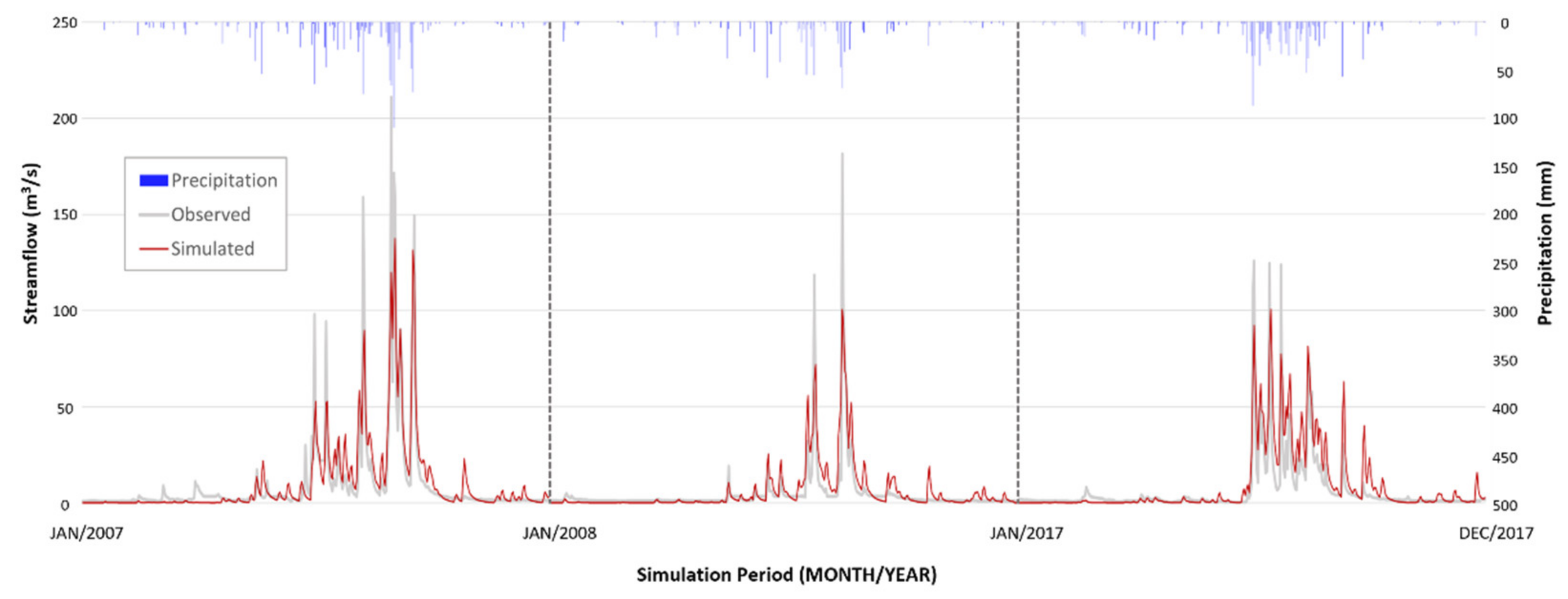
3.1. Model Calibration and Validation

For calibration, we tested all objective functions of the models and found that the functions of the “sum of squared residuals” and the “mean of squared residuals” performed most efficiently in terms of the parameter optimization, judged based on NSE. Conversely, the available functions of the “peak-weighted RMSE” or the “percent error in peak discharge” did not perform well in this study. A reason for this could be that the evaluation of the optimization result was based on the discharge volume, not the peak discharge. Considering simulations for shorter time periods, the functions based on a statistic of peak discharge may be more appropriate for use. The results of the parameterization are presented in Table 2.
The combination of optimized parameters was used as the input for the calibrated model and was further validated using the observed data of 365 days in 2017. Figure 4 shows the results for calibration and validation periods in the form of hydrographs. As presented in Table 3, the NSE and the R2 values were 0.825 and 0.822 for 2007, 0.728 and 0.715 for 2008, and 0.614 and 0.723 for 2017, respectively. These values range from “satisfactory” to “very good” according to the performance evaluation criteria presented in Table 1, indicating high model accuracy. Figure 5 shows the line of best fit between the observed and the simulated streamflow of calibration (2007–2008) and validation (2017) periods.

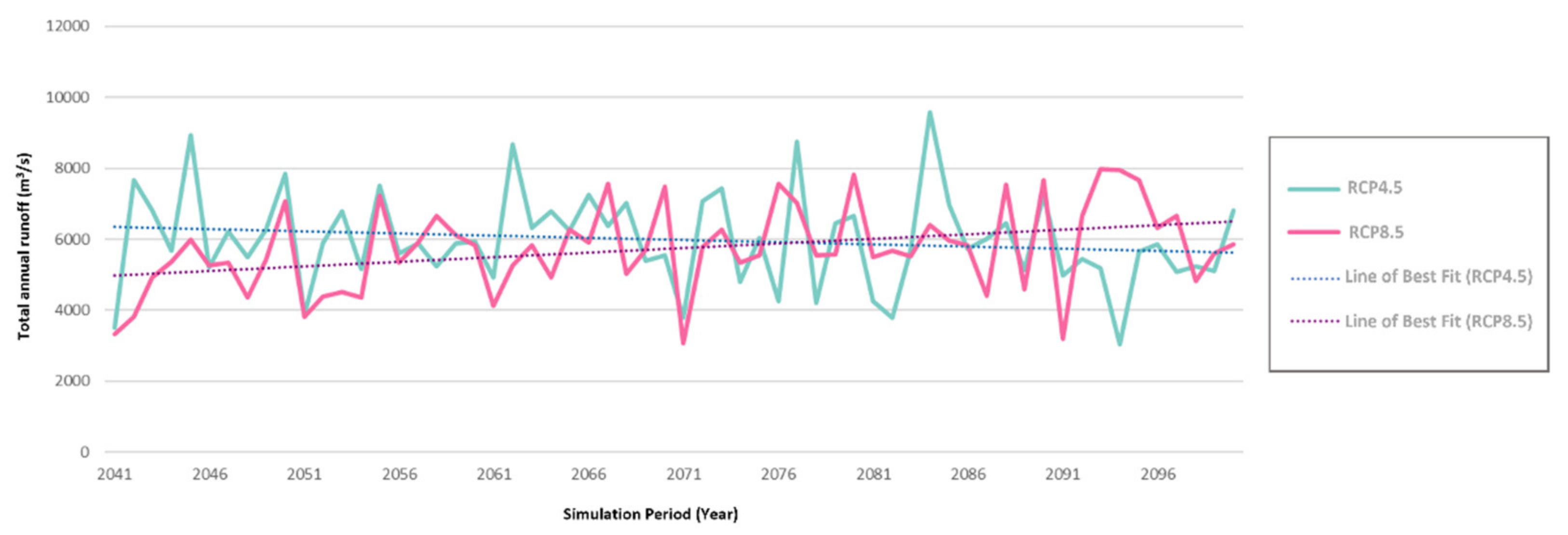
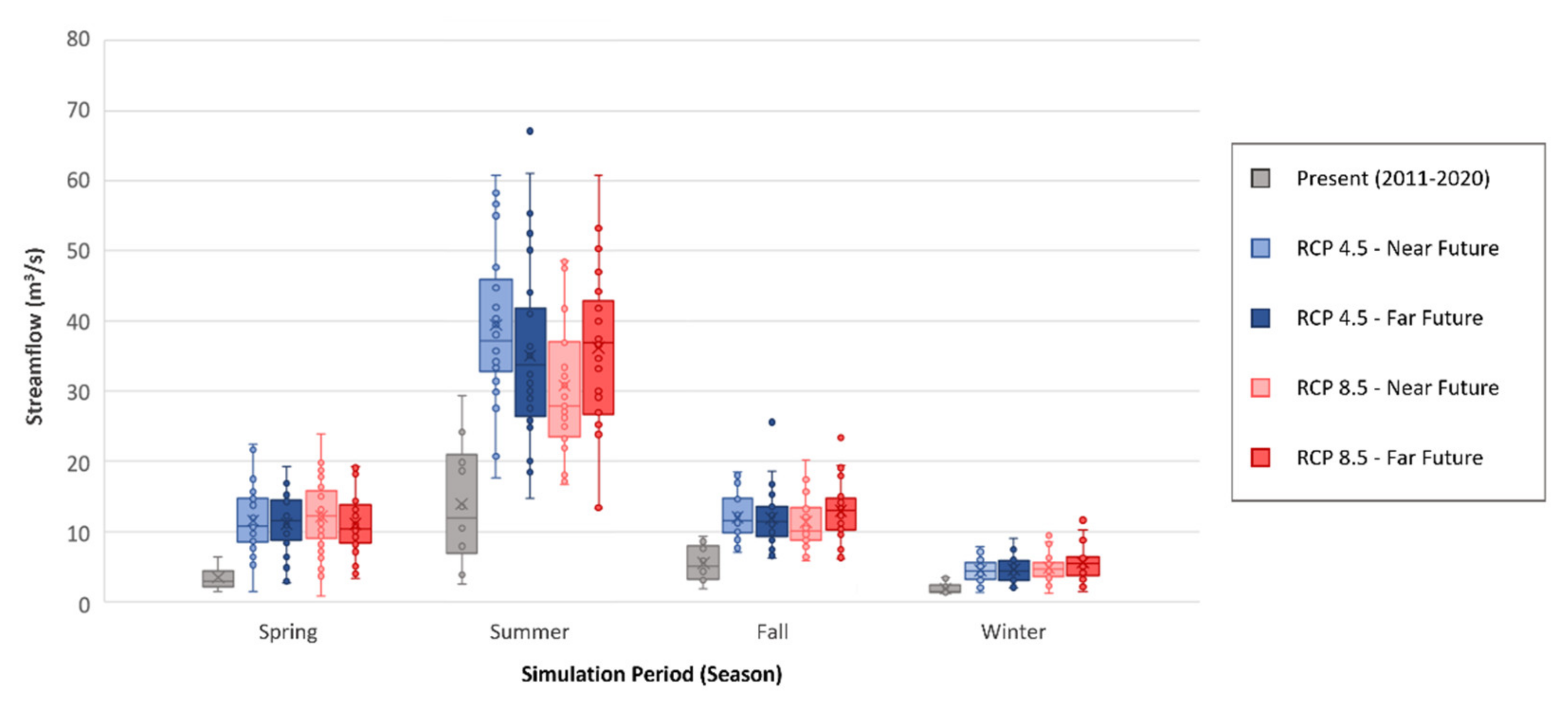
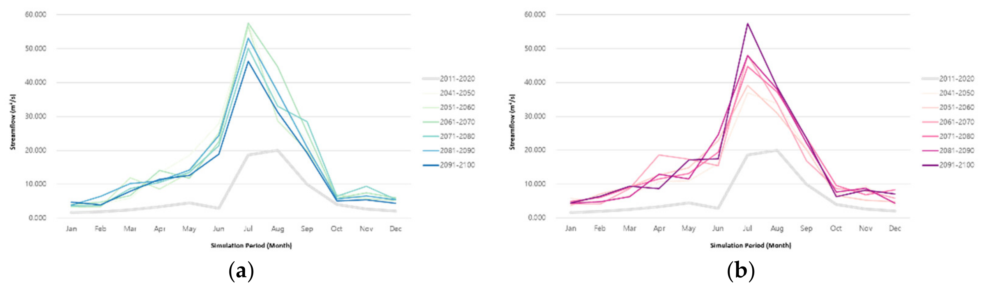
3.2. Simulation for Future Streamflow

After calibration and validation of the model, which confirmed its performance accuracy, the impact of climate change on the future discharge was assessed. In this study, we simulated the streamflow for the 60 year period between 2041 and 2100 to detect continual changes in trends over time. This was not achievable in previous studies that simulated streamflow for individual years in the future. The simulation results showed that the total annual runoff is projected to gradually decrease and approach the baseline (2011–2020) in the long run under RCP4.5, whereas it continues to increase over time under RCP8.5. These opposing trends are clearly shown in Figure 6.
As discussed earlier, rainfall is heavily concentrated in the summer season in South Korea; thus, it is important to analyze the seasonal changes in the streamflow. To do so, the simulation results of the daily streamflow for the near future (2041–2070) and the far future (2071–2100) periods were further divided into four seasons: spring (March–May), summer (June–August), fall (September–November), and winter (December–February). As shown in Figure 7, we found that the seasonal streamflow is expected to increase in all four seasons, and the gap between dry and rainy seasons is expected to increase. However, there is a considerable difference in the magnitude of the seasonality between the two RCP scenarios. Under RCP4.5, the seasonality is expected to gradually alleviate in the far future period compared to the near future period. However, under RCP8.5, the seasonality is projected to worsen in the far future period in comparison to the near future period.
The results were further analyzed by subdividing them into six decades and calculating the monthly average, as shown in Figure 8 and presented in Table 4. In the baseline period of 2011–2020, the highest monthly average streamflow was observed in August, which was attributed to the concentrated precipitation in this month. However, this was projected to change, as the highest monthly streamflow was simulated to occur in July in all six decades under both RCP4.5 and RCP8.5. However, distinct trends were observed when comparing the two scenarios. Under RCP4.5, the high July streamflow and its consequent differences from other months are expected to decrease over time. Monthly fluctuations within each season are also expected to decrease in the far future, showing smoother lines compared to earlier decades. In contrast, under RCP8.5, the average streamflow in July increased over time, while that of October tended to decrease. This implies that the difference between the two seasons is likely to worsen. Monthly fluctuations within the dry seasons are expected to increase in the future.

4. Discussion

4.1. Findings of Site-Specific Trend of Future Streamflow

Projections of the near and the far future streamflow in the Bocheongcheon basin in this study shed a light on the site-specific trend, distinct from other previous studies conducted over South Korea. Before discussing the implications of the simulation results for water resources management policy, major findings are reviewed in this chapter.
Bae et al. detected a decreasing trend in spring streamflow and an increasing trend in summer streamflow in South Korea for the period between 1968 and 2001 and warned that these trends are likely to continue in the future [5]. If these trends were to severely worsen, it would suggest increased risk of droughts in the spring and floods in the summer. However, the results of our study found that these trends do not apply to the Bocheongcheon basin, as its streamflow is projected to increase in all months and seasons over the six decades in the future (2041–2100). Our simulation results suggest that the water resources managers of the basin should focus on potential threats that are more likely to result from increasing streamflow.
Jung et al. spatially analyzed future hydrologic elements and projected decreases in dry season flow in the southern regions of the country in contrast to slight increases in the northern regions. It was forecasted that these spatial distributions will become more distinct in the far future period of the 2080s [8]. However, such projections could not aid the water resources managers of the Bocheongcheon Basin of Geumgang River, as the basin is located in the central region. As the pattern of streamflow varies by regions, we suggest that future streamflow be simulated at a basin level if the purpose of hydrologic modeling is to serve as evidence for local adaptive measures.

4.2. Implications for Water Resources Management

In Korea, there have been numerous studies which suggested water resources management measures against stream depletion and water pollution of rivers and lakes, which are worsening due to the recently increased occurrences of serious drought [47,48,49]. However, as there are concerns about the widening variation in rainfall by region, which may impair regional water supply stability and riverine ecosystem health, it is essential to prepare a scientific basis for regional or local water resources management at a smaller basin level.
The results of this study can serve as such scientific evidence guiding decision makers, as the Bocheongcheon basin is projected to have increased streamflow in all months and seasons over the six decades (2041–2100) in the future. The projected increase in the overall streamflow, especially the summer season flow, does not directly bring advantages with enhanced amounts of water resources but rather indicates increased flood risk in the region during the wet season. The local decision-makers involved in water resources management must develop more robust adaptive plans for multiple threats following the increased flood risk. In this chapter, two major goals for management policy are suggested for the study site based on the simulation results:
  • The simulation results suggest the need for adaptive measures against an aggravating threat in deterioration of water quality due to increased inflow of pollutants into rivers carried by increased surface runoff. Especially for the Bocheongcheon basin, an area subject to intensive management of agricultural non-point pollutants, appropriate best management practices (BMPs) must be carefully selected and placed to secure quality water near agricultural land [50,51,52]. The effect of BMPs can be enhanced when coupled with maintenance of soil loss reduction infrastructure in high-altitude arable lands, which were identified as major sources of agricultural non-point pollutants in South Korea [53]. For the urban areas in the basin, reinforcement of early rainwater treatments by LID (low impact development) application should be considered to allow for more natural purification [54,55].
  • As the future summer streamflow is projected to significantly increase in the study site under climate change, local water resources managers should consider increasing the security degree of dams and other river infrastructures. According to the Third National Climate Change Adaptation Plan, “strengthening site-specific flood response” is promoted as the main task of sustainable flood management under the changing climate [53]. Measures to expand sewage pipes and to place more storage facilities and pumping stations are being considered in urban areas that are identified to experience an increase in rainfall runoff exceeding the installed capacity. Therefore, the projected future rainfall runoff in this study can be considered when newly setting design standards for dams and reservoirs. To expand reservoir capacity in the region, improved use of near-by agricultural reservoirs can also be a possible strategy, as there are approximately 300 of them in Boeun-gun, Okcheon-gun, and Yeongdong-gun of the study site [56].
In addition to the explored implications for water resources management policy, the simulation results of the study are valuable, as they firmly endorse the national initiatives for reduction of greenhouse gas emissions. Intensification of seasonal differences and fluctuations was projected under RCP 8.5 comparative to RCP 4.5, which suggests more difficulty caused for water resources managers to secure stable source of clean water and to prevent water-related disasters. This finding strongly indicates the need to reduce greenhouse gas emissions more assertively. Similarly, the nationally announced goal of achieving carbon neutrality by 2050 by harnessing green innovations and advanced digital technologies [57] is strongly supported by this study.

5. Conclusions

In this study, future rainfall runoff was simulated using the HEC-HMS model in the Bocheongcheon Basin of the Geumgang River to help establish efficient future water resources management measures. For the simulation, parameter values for loss, transform, and routing methods were individually calculated based on the land cover and the soil map of the target site and were applied to the model. Calibration of the model was conducted by combining the trial-and-error and the built-in optimization methods, resulting in an efficient simulation of discharge at junction 3 for the period of 2007 and 2008. When compared to the observed streamflow, the simulated streamflow showed high NSE and R2 values of 0825 and 0822 for 2007 and 0728 and 0715 for 2008, respectively. Using the calibrated parameters, we simulated the streamflow for 2017, which also showed fine NSE and R2 values of 0614 and 0723, respectively.
After confirming the model performance, the streamflow for the 60 year period (2041–2100) under RCP4.5 and RCP8.5 was simulated. The results revealed distinct changing trends in the streamflow in different time periods depending on the scenario. This indicated potential threats that may arise under the current water resources management policy. The future water resources management policy should be based on the change in streamflow controlled by the changing intensity and the frequency of rainfall during the wet and the dry seasons under the new climate regime. As such, the results derived in this study are meaningful, as they simulate the impact of climate change on the streamflow over an extensive period of 60 years instead of simulating the streamflow over a single year. Based on the 60 year simulation results, policy measures against increased threats of deteriorating water quality and increasing flood risk were suggested.
However, we would like to highlight a few factors that should be further considered when applying the findings of this study to future water resources management policy. The results of this study are affected to an extent by uncertainties resulting from hydrologic modeling and climate change scenarios. In future studies, these uncertainties should be quantified for more precise impact assessment of climate change on water resources. To reduce uncertainty caused by using a single hydrologic model, researchers can consider multi-model simulation.

Author Contributions

This paper presents the results of collaborative teamwork. Conceptualization: Y.K.; methodology: Y.K. and J.Y.; software: Y.K. and J.Y.; validation: Y.K.; formal analysis: Y.K., J.Y., and K.L.; investigation: Y.K.; resources: S.J.; data curation: Y.K. and H.I.C.; writing—original draft preparation: Y.K.; writing—review and editing: K.L., J.Y., H.C.S., and S.J.; visualization: Y.K. and K.L.; supervision: S.J.; project administration: H.C.S.; funding acquisition: S.J. All authors have read and agreed to the published version of the manuscript.

Funding

This research was supported by the Korea Environment Industry & Technology Institute (KEITI) through the Decision Support System Development Project for Environmental Impact Assessment Program, funded by the Korea Ministry of Environment (MOE), grant number 2020002990009.

Institutional Review Board Statement

Not applicable.

Informed Consent Statement

Not applicable.

Data Availability Statement

The data presented in this study are available on request from the corresponding author. The data are not publicly available due to a research project, currently being conducted.

Conflicts of Interest

The authors declare no conflict of interest.

References

  1. Korea Meteorological Administration. Climate Change Forecast Analysis Report for Korean Peninsula; Korea Meteorological Administration: Seoul, Korea, 2018. (In Korean)
  2. Park, C.Y.; Moon, J.Y.; Cha, E.J.; Yun, W.T.; Choi, Y.E. Recent Changes in Summer Precipitation Characteristics over South Korea. J. Korean Geogr. Soc. 2008, 43, 324–336. (In Korean) [Google Scholar]
  3. Lee, M.H.; Im, E.S.; Bae, D.H. Future Prediction in Inflow of Major Multi-Purpose Dams in South Korea. J. Wetl. Res. 2019, 21, 107–116. (In Korean) [Google Scholar]
  4. Lee, S.H.; Kim, E.K.; Heo, I.H. A Study on Variability of Extreme Precipitation by Basin in South Korea. J. Korean Assoc. Reg. Geogr. 2011, 17, 505–520. (In Korean) [Google Scholar]
  5. Bae, D.H.; Jung, I.W.; Chang, H.J. Potential Changes in Korean Water Resources Estimated by High-Resolution Climate Simulation. Clim. Res. 2008, 35, 213–226. [Google Scholar] [CrossRef]
  6. Choi, G.Y. Spatiotemporal Changes in Seasonal Multi-Day Cumulative Extreme Precipitation Events in the Republic of Korea. J. Korean Assoc. Reg. Geogr. 2015, 21, 98–113. (In Korean) [Google Scholar]
  7. Jung, I.W.; Bae, D.H.; Kim, G. Recent Trends of Mean and Extreme Precipitation in Korea. Int. J. Climatol. 2011, 31, 359–370. [Google Scholar] [CrossRef]
  8. Jung, I.W.; Bae, D.H.; Lee, B.J. Possible Change in Korean Streamflow Seasonality Based on Multi-Model Climate Projections. Hydrol. Process. 2013, 27, 1033–1045. [Google Scholar] [CrossRef]
  9. Kim, J.S.; Choi, C.U. Impacts of Changes in Climate and Land Use/Land Cover Change under Climate Change Scenario on Streamflow in the Basin. J. Korean Soc. Geospat. Inf. Syst. 2013, 21, 107–116. (In Korean) [Google Scholar]
  10. Yang, H.K. Water Balance Change of Watershed by Climate Change. J. Korean Geogr. Soc. 2007, 42, 405–420. [Google Scholar]
  11. Korea Meteorological Administration. Weather Characteristics in Summer 2020 (8 September 2020). (In Korean). Available online: https://www.kma.go.kr/eng/index.jsp (accessed on 9 September 2021).
  12. National Assembly Budget Office. Disaster Damage Support System Status and Analysis of Financial Needs; National Assembly Budget Office: Seoul, Korea, 2019. (In Korean) [Google Scholar]
  13. Milly, P.C.D.; Betancourt, J.; Falkenmark, M.; Hirsch, R.M.; Kundzewicz, Z.W.; Lettenmaier, D.P.; Stouffer, R.J. Climate Change. Stationarity Is Dead: Whither Water Management? Science 2008, 319, 573–574. [Google Scholar] [CrossRef]
  14. Bates, B.; Kundzewicz, Z.W.; Wu, S.; Palutikof, J.P. Climate Change and Water, IPCC Technical Paper VI; IPCC Secretariat: Geneva, Switzerland, 2008; p. 210. [Google Scholar]
  15. Bae, D.H.; Jung, I.W.; Lee, B.J.; Lee, M.H. Future Korean Water Resources Projection Considering Uncertainty of GCMs and Hydrological Models. J. Korea Water Resour. Assoc. 2011, 44, 389–406. (In Korean) [Google Scholar] [CrossRef]
  16. Jeong, S.M.; Seo, H.D.; Kim, H.S.; Han, K.H. Sensitivity Assessment on Daecheong Dam basin Streamflows According to the Change of Climate Components—Based on the 4th IPCC Report. J. Korea Water Resour. Assoc. 2008, 41, 1095–1106. (In Korean) [Google Scholar] [CrossRef]
  17. Kim, D.H.; Han, D.G.; Kim, H.S. Analysis of Cases and Prospects of Continuous Heavy Rain on the Korean Peninsula. Water Future 2018, 51, 38–43. (In Korean) [Google Scholar]
  18. Jin, H.; Liang, R.; Wang, Y.; Tumula, P. Flood-Runoff in Semi-Arid and Sub-Humid Regions, a Case Study: A Simulation of Jianghe Watershed in Northern China. Water 2015, 7, 5155–5172. [Google Scholar] [CrossRef] [Green Version]
  19. Kim, J.P.; Kim, G.W. The Impact of Climate Change on the Trends of Precipitation Effectiveness Ratio and Runoff Data in South Korea. J. Korea Water Resour. Assoc. 2011, 44, 683–694. (In Korean) [Google Scholar] [CrossRef]
  20. Knebl, M.R.; Yang, Z.L.; Hutchison, K.; Maidment, D.R. Regional Scale Flood Modeling Using NEXRAD Rainfall, GIS, and HEC-HMS/RAS: A Case Study for the San Antonio River Basin Summer 2002 Storm Event. J. Environ. Manag. 2005, 75, 325–336. [Google Scholar] [CrossRef] [PubMed]
  21. Chu, X.; Steinman, A. Event and Continuous Hydrologic Modeling with HEC-HMS. J. Irrig. Drain. Eng. 2009, 135, 119–124. [Google Scholar] [CrossRef]
  22. Zema, D.A.; Labate, A.; Martino, D.; Zimbone, S.M. Comparing Different Infiltration Methods of the HEC-HMS Model: The Case Study of the Mesima Torrent (Southern Italy). Land Degrad. Develop. 2017, 28, 294–308. [Google Scholar] [CrossRef]
  23. Nyaupane, N.; Mote, S.R.; Bhandari, M.; Kalra, A.; Ahmad, S. Rainfall-Runoff Simulation Using Climate Change Based Prediction in HEC-HMS Model for Irwin Creek, Charlotte, North Carolina. In World Environmental and Water Resources Congress 2018: Watershed Management, Irrigation and Drainage, and Water Resources Planning and Management; American Society of Civil Engineers: Reston, VA, USA, 2018; pp. 352–363. [Google Scholar]
  24. Meenu, R.; Rehana, S.; Mujumdar, P.P. Assessment of Hydrologic Impacts of Climate Change in Tunga-Bhadra River Basin, India with HEC-HMS and SDSM. Hydrol. Process. 2013, 27, 1572–1589. [Google Scholar] [CrossRef]
  25. Halwatura, D.; Najim, M.M.M. Application of the HEC-HMS Model for Runoff Simulation in a Tropical Catchment. Environ. Modell. Softw. 2013, 46, 155–162. [Google Scholar] [CrossRef]
  26. Hwang, B.G.; Yang, S.B. Analysis of Stormwater and Runoff Characteristics in Anseong Basin Using HEC-HMS. J. Korea Acad.-Ind. Coop. Soc. 2018, 19, 17–24. (In Korean) [Google Scholar]
  27. Choudhari, K.; Panigrahi, B.; Paul, J.C. Simulation of Rainfall-Runoff Process Using Hec-HMS Model for Balijore Nala Watershed, Odisha, India. Int. J. Geomat. Geosci. 2014, 5, 253–265. [Google Scholar]
  28. Oleyiblo, J.O.; Li, Z. Application of HEC-HMS for Flood Forecasting in Misai and Wan’an Catchments in China. Water Sci. Eng. 2010, 3, 14–22. [Google Scholar]
  29. Emam, A.R.; Mishra, B.K.; Kumar, P.; Masago, Y.; Fukushi, K. Impact Assessment of Climate and Land-Use Changes on Flooding Behavior in the Upper Ciliwung River, Jakarta, Indonesia. Water 2016, 8, 559. [Google Scholar] [CrossRef] [Green Version]
  30. Ahearn, D.S.; Sheibley, R.W.; Dahlgren, R.A.; Anderson, M.; Johnson, J.; Tate, K.W. Land Use and Land Cover Influence on Water Quality in the Last Free-Flowing River Draining the Western Sierra Nevada, California. J. Hydrol. 2005, 313, 234–247. [Google Scholar] [CrossRef]
  31. Bhatt, A.; Yadav, H.L.; Kumar, D. Estimation of Infiltration Parameter for Tehri Garhwal Catchment. Int. J. Eng. Res. Technol. 2012, 1, 1–6. [Google Scholar]
  32. Lee, B.J.; Jung, I.W.; Bae, D.H. Parameter Regionalization of Semi-distributed Runoff Model Using Multivariate Statistical Analysis. J. Korea Water Resour. Assoc. 2009, 42, 149–160. (In Korean) [Google Scholar] [CrossRef]
  33. Chang, H.; Jung, I.W. Spatial and Temporal Changes in Runoff Caused by Climate Change in a Complex Large River Basin in Oregon. J. Hydrol. 2010, 388, 186–207. [Google Scholar] [CrossRef]
  34. Vicuna, S.; Dracup, J.A.; Lund, J.R.; Dale, L.L.; Maurer, E.P. Basin-Scale Water System Operations with Uncertain Future Climate Conditions: Methodology and Case Studies. Water Resour. Res. 2010, 46. [Google Scholar] [CrossRef] [Green Version]
  35. Jung, T.S.; Hwang, J.H.; Kim, T.S.; Lee, H.G. Three-Dimensional Modeling of Water Circulation of Lake Daechung during Flood Event. In Proceedings of the KSCE 2002 Convention; Korean Society of Civil Engineers: Seoul, Korea, 2002; pp. 1597–1600. [Google Scholar]
  36. Kwon, Y.H.; Han, S.I.; Lee, J.B. Pollution Loadings in DaeChungHo Watershed. J. Korean Soc. Water Wastewater 2002, 16, 581–595. (In Korean) [Google Scholar]
  37. Park, J.H.; Kwon, H.H.; No, S.H. Outlook of Discharge for Daecheong and Yongdam Dam Watershed Using A1B Climate Change Scenario Based RCM and SWAT Model. J. Korea Water Resour. Assoc. 2011, 44, 929–940. (In Korean) [Google Scholar] [CrossRef]
  38. Kim, U.T.; Lee, D.R.; Yoo, C. Effects of Climate Change on the Streamflow for the Daechung Dam Watershed. J. Korea Water Resour. Assoc. 2004, 37, 305–314. (In Korean) [Google Scholar] [CrossRef] [Green Version]
  39. U.S. Army Corps of Engineers. Hydrologic Modeling System HEC-HMS, User’s Manual; Hydrologic Engineering Center: Davis, CA, USA, 2018.
  40. Lee, S.H.; Bae, S.K. Estimation of Precipitation Recharge in the Pyungchang River Basin Using SCS-CN Method. J. Environ. Sci. 2004, 13, 1033–1039. (In Korean) [Google Scholar]
  41. Joo, J.W.; Kjeldsen, T.; Kim, H.J.; Lee, H.S. A Comparison of Two Event-Based Flood Models (ReFH-Rainfall Runoff Model and HEC-HMS) at Two Korean Catchments, Bukil and Jeungpyeong. KSCE J. Civ. Eng. 2014, 18, 330–343. [Google Scholar] [CrossRef]
  42. Ministry of the Environment. Standard Guidelines for Calculating Flood Volume; Ministry of the Environment: Sejong-si, Korea, 2019. (In Korean)
  43. Nash, J.E.; Sutcliffe, J.V. Review Flow Forecasting through Conceptual Models Part I: A Discussion of Principles. J. Hydrol. 1970, 10, 282–290. [Google Scholar] [CrossRef]
  44. Moriasi, D.N.; Gitau, M.W.; Pai, N.; Daggupati, P. Hydrologic and Water Quality Models: Performance Measures and Evaluation Criteria. Trans. ASABE 2015, 58, 1763–1785. [Google Scholar]
  45. Kim, Y.; Yu, J.; Lee, K.; Sung, H.C.; Jeon, S. Examining Application of HEC-HMS Model for Prediction of Future Rainfall Runoff under Climate Change—For Daecheong Dam basin of Geum River. J. Clim. Chang. Res. 2020, 11, 609–619. (In Korean) [Google Scholar] [CrossRef]
  46. Van Vuuren, D.P.; Edmonds, J.; Kainuma, M.; Riahi, K.; Thomson, A.; Hibbard, K.; Hurtt, G.C.; Kram, T.; Krey, V.; Lamarque, J.; et al. The Representative Concentration Pathways: An Overview. Clim. Chang. 2011, 109, 5–31. [Google Scholar] [CrossRef]
  47. Kim, S.M.; Kang, M.S.; Jang, M.W. Assessment of Agricultural Drought Vulnerability to Climate Change at a Municipal Level in South Korea. Paddy Water Environ. 2018, 16, 699–714. [Google Scholar] [CrossRef]
  48. Ahn, S.R.; Jeong, J.H.; Kim, S.J. Assessing Drought Threats to Agricultural Water Supplies under Climate Change by Combining the SWAT and MODSIM Models for the Geum River Basin, South Korea. J. Hydrol. Sci. 2016, 61, 2740–2753. [Google Scholar] [CrossRef] [Green Version]
  49. Nam, W.H.; Hayes, M.J.; Svoboda, M.D.; Tadesse, T.; Wilhite, D.A. Drought Hazard Assessment in the Context of Climate Change for South Korea. J. Agric. Water Manag. 2015, 160, 106–117. [Google Scholar] [CrossRef]
  50. Bosch, N.S.; Evans, M.A.; Scavia, D.; Allan, J.D. Interacting effects of climate change and agricultural BMPs on nutrient runoff entering Lake Erie. J. Great Lakes Res. 2011, 40, 581–589. [Google Scholar] [CrossRef]
  51. Briak, H.; Mrabet, R.; Moussadek, R.; Aboumaria, K. Use of a calibrated SWAT model to evaluate the effects of agricultural BMPs on sediments of the Kalaya river basin (North of Morocco). J. Int. Soil Water Conserv. Res. 2017, 7, 176–183. [Google Scholar] [CrossRef]
  52. Rousseau, A.N.; Savary, S.; Hallema, D.W.; Gumiere, S.J.; Foulon, E. Modeling the effects of agricultural BMPs on sediments, nutrients, and water quality of the Beaurivage River watershed (Quebec, Canada). J. Can. Water Res. 2013, 38, 99–120. [Google Scholar] [CrossRef]
  53. The Government of the Republic of Korea. The Third National Climate Change Adaptation Plan (2021–2025); The Government of the Republic of Korea: Seoul, Korea, 2020. (In Korean)
  54. Liu, Y.; Cibin, R.; Bralts, V.F.; Chaubey, I.; Bowling, L.C.; Engel, B.A. Optimal selection and placement of BMPs and LID practices with a rainfall-runoff model. Environ. Modell. Softw. 2016, 80, 281–296. [Google Scholar] [CrossRef] [Green Version]
  55. Zeng, J.; Huang, G.; Luo, H.; Mai, Y.; Wu, H. First flush of non-point source pollution and hydrological effects of LID in a Guangzhou community. Sci. Rep. 2019, 9, 13865. [Google Scholar] [CrossRef] [PubMed] [Green Version]
  56. Kim, H.Y.; Shin, C.; Park, Y.; Moon, J. Water Resources Management in the Republic of Korea: Korea’s Challenge to Flood & Drought with Multi-Purpose Dam and Multi-Regional Water Supply System; Inter-American Development Bank: Washington, DC, USA, 2020. [Google Scholar]
  57. The Government of the Republic of Korea. 2050 Carbon Neutral Strategy of the Republic of Korea towards a Sustainable and Green Society; The Government of the Republic of Korea: Seoul, Korea, 2020.
Figure 1. Location of the Bocheongcheon Basin of Geumgang, South Korea.
Water 13 02516 g001
Figure 2. Schematic diagram of the HEC-HMS model structure.
Water 13 02516 g002
Figure 3. Physical characteristics of the Bocheongcheon Basin: (a) Level 1 land cover map (reclassified from Level 3 land cover map); and (b) soil type map.
Water 13 02516 g003
Figure 4. Observed and simulated hydrographs for calibration (2007–2008) and validation (2017) periods.
Water 13 02516 g004
Figure 5. Observed and simulated hydrographs for the calibration and validation periods of (a) 2007; (b) 2008; and (c) 2017.
Water 13 02516 g005
Figure 6. Change in total annual streamflow (m3/s) under RCP4.5 and RCP8.5.
Water 13 02516 g006
Figure 7. Seasonal streamflow under RCP4.5 and RCP8.5 for near (2041–2070) and far (2071–2100) future periods.
Water 13 02516 g007
Figure 8. Projected monthly average streamflow under (a) RCP4.5 and (b) RCP8.5 by decade.
Water 13 02516 g008
Table 1. Performance evaluation criteria for Nash–Sutcliffe efficiency (NSE) and coefficient of determination (R2) for the modeling of flow 1.
MeasurePerformance Evaluation Criteria
Not SatisfactorySatisfactoryGoodVery Good
NSENSE ≤ 0.500.50 < NSE ≤ 0.700.70 < NSE ≤ 0.800.80 < NSE ≤ 1
R2R2 ≤ 0.600.60 < R2 ≤ 0.750.75 < R2 ≤ 0.850.85 < R2 ≤ 1
1 Includes all streamflow, surface runoff, and baseflow, as appropriate.
Table 2. Final calibrated model parameters.
ElementModel Parameters
SCS-CNKTcMuskingum KMuskingum X
Sub-basin 142.40622031694--
Sub-basin 226.71609741694--
Sub-basin 317.07105671098--
Sub-basin 423.11303910058--
Sub-basin 538.149----
Sub-basin 643.33970784125--
Reach 1---149.4900014
Reach 2---27.3270014
Table 3. Calibration and validation results.
PeriodTotal Outflow 1Statistical Measure
ObservedSimulatedR2NSE
Calibration20073730.183939.0008220825
20081731.002167.1007150728
Validation20172385.303389.6007230614
1 Refers to the sum of daily outflow (m3/s) over the year from junction 3.
Table 4. Differences in average streamflow between July and October by decade.
ScenarioPeriodMonthly Average Streamflow (m3/s)
JulyOctoberDifference
(July–October)
Change Over Decades 1
RCP4.52041–205057.412690150.511
2051–206056.510677249.738 −0773
2061–207057.590591051.680 +1942
2071–208050.151638043.772 −7909
2081–209053.128557947.549 +3777
2091–210046.287507641.211 −6338
RCP8.52041–205037.073683030.244
2051–206039.190662632.564 +2321
2061–207048.131865839.473 +6909
2071–208044.736962035.116 −4357
2081–209048.015760140.415 +5298
2091–210057.444623151.213 +10.798
1 Refers to the change in the difference between July and October compared to the previous decade.
Publisher’s Note: MDPI stays neutral with regard to jurisdictional claims in published maps and institutional affiliations.

