
Analysis of Basin Morphologic Characteristics and Their Influence on the Water Yield of Mountain Watersheds Upstream of the Xiongan New Area, North China


Key Laboratory for Agricultural Water Resources, Hebei Key Laboratory for Agricultural Water-Saving, Center for Agricultural Resources Research, Institute of Genetics and Developmental Biology, Chinese Academy of Sciences, Shijiazhuang 050001, China
*
Author to whom correspondence should be addressed.
Water 2021, 13(20), 2903; https://doi.org/10.3390/w13202903
Submission received: 12 August 2021
/
Revised: 8 October 2021
/
Accepted: 9 October 2021
/
Published: 15 October 2021
(This article belongs to the Special Issue Advances in Studies on Ecohydrological Processes in the Arid Area)
Abstract
:In this study, based on the DEM, we extracted the drainage networks and watersheds of the Daqing River with ArcGIS, investigated the basin characteristics and the differences in their spatial distributions and analyzed the relations of the drainage density with some surface conditions and how the drainage density influenced the water yield. The results suggested a power function between the mainstream length and drainage area, showing that with the increase in basin area, the basins became longer. The result of the power function between the relief and drainage area with negative exponent values means the relief changed more slowly with increasing basin area. The values of the circularity ratio and elongation ratio indicate that the basin shape of the mountain watersheds in the Daqing River was narrow and predisposed to flooding during periods of heavy rainfall. The orders of the streams in the mountain watersheds ranged from five to seven. The average bifurcation ratio of those nine mountainous watersheds reveals the order of the u + 1 rivers in each basin of the Daqing River was on average 4 times larger than that of order u rivers. The drainage density (Dd) was high in the north and low in the south of the Daqing River. Rainfall was negatively correlated with drainage density, but the correlation between them was not significant at the 0.05 level. Drainages developed in places with poor vegetation cover. The drainages in the southwest, north and west developed considerably, while drainages in the east and southeast did not develop much. Yet, the available data showed the impact of the watershed area, elongation ratio and drainage density on the water yield was not significant. In contrast, there was a significant positive correlation between channel slope and the water yield modulus. The hypsometric integrals and the relation between drainage density and hypsometric integral suggest that the landform evolution of the mountain basins along the Daqing River were in the old stage with no further increase trend of drainage density in the future.
1. Introduction
Mountain rivers are important corridors that link upland and lowland environments and mediate the supply, transport, andstorage of organic and inorganic materials [1,2]. Mountain rivers play an important role in flood control and perform other functions, such as conserving water resources, regulating the microclimate, and maintaining water ecology and biodiversity. However, they often face problems such as short-term flood responses, water shortages in the dry season, and river channel artificialization [3].
Mountain rivers are often confined by immobiletopographic features, such as bedrock and large boulders with channel gradients commonly exceeding 1% [2,4,5]. This leads to these types of rivershaving steep hydraulic rating curves that initiate rapid transport of small sand and gravel fractions within the large structural matrix formed by large, century-scale floods nested within an even larger geological context [2,6]. Stream network characteristics are the basic parameters of hydrological and water environment research, as well as one of the important contents of terrain analysis and hydrological analysis. A stream network is a conduit that links the upstream catchment processes and its impacts on the downstream streams and floodplains [7]. The stream network structure is established through its branches, confluence and bifurcation. Basin parameters, such as river type, drainage density (Dd), stream number and length, affect the process of rainfall and runoff [8]. While Dd is defined as the ratio of total channellength in a catchment to the total catchment area [9], it is a scale-independent parameter that is influenced by the accurate representation of topography, which is primarily represented in the form of digital elevation models (DEMs). A plethora of studies have sought to understand how the resolution of topographic data governs basin parameters [7,10,11,12] and the algorithm for extraction of river networks, including the flow direction algorithm and convergence threshold determination [8,13]. In fact, river network structuresand their embedded hydrological dynamics play an important role in ecohydrological processes [14]. Therefore, after obtaining stream networks from DEMs, further studies need to reveal the relationship between the features of extracted drainage networks and other natural factors based on the widely available and easily accessible DEM, the significance of the characteristics of stream networks in typical rivers and how the underlying geomorphic processes governing the initiation, growth and development of channel networks, not just how the features of the DEMs affect stream networks, for example, the resolution.
The mountain rivers in China are seasonal and have the following characteristics [15]: they have steep slopes with short runoff generation and confluence times [16]; they are subject to serious soil and water erosion, which increases the pressure on river flood controls [17]; and they are associated with strong river channel scouring, simple river channel forms and vegetation, and severe riverbed erosion [18]; and they experience cold, long winters, low rainfall with uneven seasonal distribution, and severe non-point source pollution that is difficult to control during flood and snowmelt periods [3].
The plan to construct the Xiongan New Area, which was reported by China’s Central Committee and State Council, is regarded as “a strategy crucial for the millennium to come” by the Chinese government (http://politics.people.com.cn/GB/n1/2017/0401/c1001-29185929.html, in Chinese; access date: 8 October 2021). The Xiongan New Area prioritizes eco-environmental protection and green living environments. One noticeable characteristic of Xiongan is that it is located next to Baiyangdian Lake, the largest natural freshwater wetland on the semiarid North China Plain (NCP), which is known as the “Pearl of North China” and the “Kidney of North China” [19,20,21]. The lake is located in the middle and lower reaches of the Daqing River basin, which is a typical mountain basin in northern China and has an important impact on the central North China Plain in terms of climate regulation and environmental characteristics [22]. Due to the steep terrain, thin soil cover, poor vegetation and fan-shaped tributary distribution of the area and the characteristics of high intensity, short duration, uneven distribution and sudden occurrence of the storm events that occur in the Daqing River basin, floods with high and concentrated peaks with short lead timesare often triggered [23], which easily cause significant flooding and serious soil erosion. The New Area is located in a region of slow flooding and stagnation on the Daqing River, and its current flood recurrence period is only one in ten years; the area has suffered many flood disasters [24]. Sudden flash floods cause a large amount of coarse sand gravel to pile up in the downstream channel, destroying villages, burying farmland and causing siltation of river channels, which all bring considerable economic losses to the local people.
Previous studies about the Daqing River focus on the water environment (Xu and Wang, 2000) and the runoff and sediment characteristics [25,26,27,28]. Therefore, the objective of this paper is to study the characteristics of drainage networks and watershed geometry of the mountain watersheds of the Daqing River; the relations of drainage density with topography, vegetation coverage and surface material composition; and discuss the implications of indices of drainage network and watershed geometry for water yield and watershed evolution. Our results may provide some basic watershed characteristic data for other scholars in this basin study and a reference for further study of the water cycle process and effective utilization of water resources in the Daqing River basin and a scientific basis for the formulation of flood control policies and water conservation in the Xiongan New Area.
2. Study Area
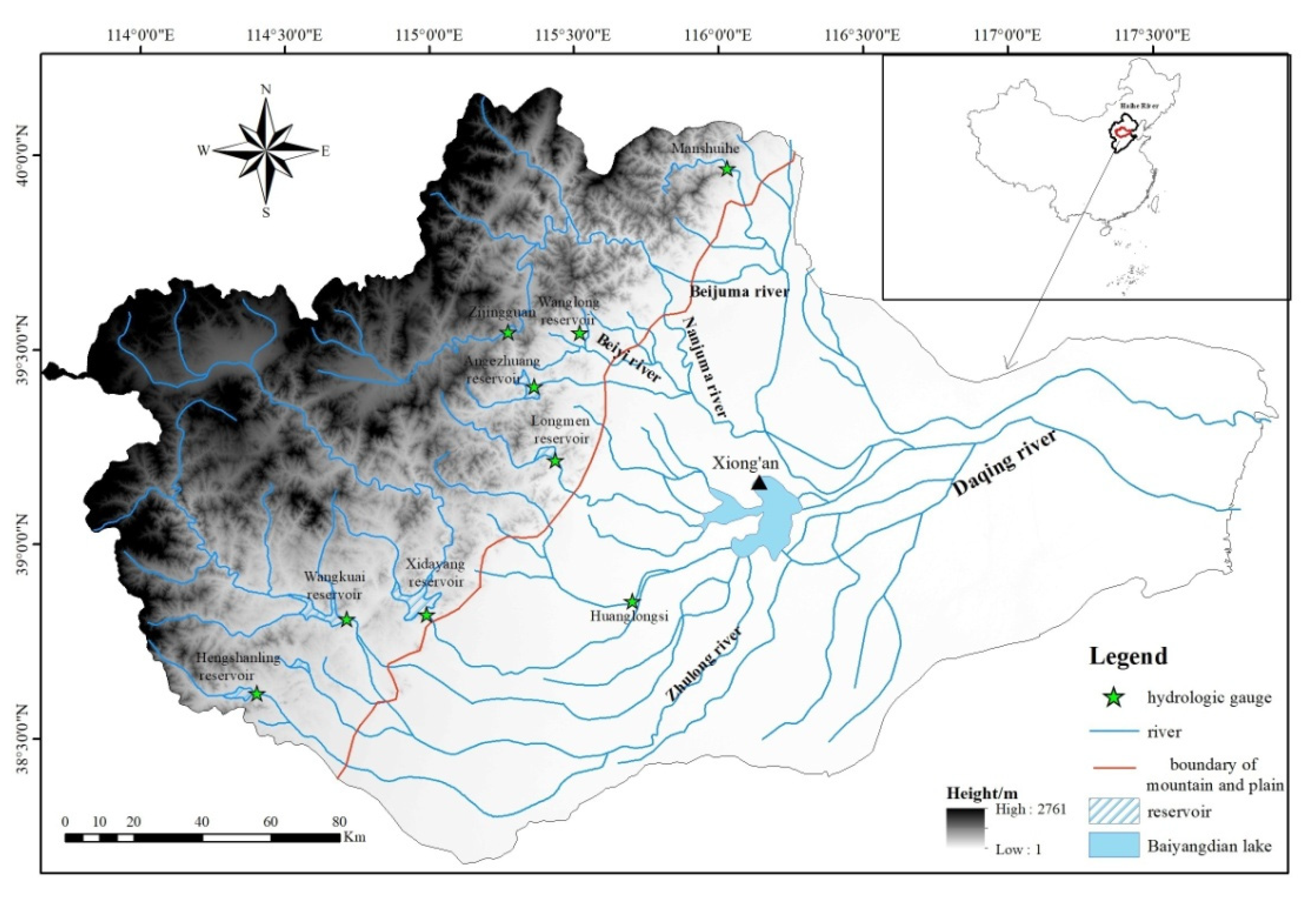
The Daqing River is a primary tributary of the Haihe River in northern China and is located at 113°34′3″–117°46′7″ E, 38°4′42″–40°3′2″ N. The area of the watershed is 43,060 km2, with a length of 275 km, an average width of 156 km and an average slope of 5.22%. The average annual runoff is 4.3 × 10⁸ m3. According to the Water Resource Zoning Map of the Haihe River basin, provided by the Haihe River Water Conservancy Commission (HRWCC), the Daqing River basin mainly consists of two geomorphic units: the upper reaches of the west are mountainous areas thataccount for 43% of the basin area, and the middle and lower reaches of the east are plains areas (Figure 1).The river basin is fan-shaped and divided into northern and southern branches. The southern branches of the mountain basin are mainly composed of six tributaries, including the Ci River (CIR), Sha River (SR), Tang River (TR), Jie River (JR), Cao River (CR) and Bao River (BR). After entering the plain, the Ci River and Sha River converge into the Zhulong River. The northern branches are mainly composed of four tributaries, namely, the Zhongyi River (ZYR), Beiyi River (BYR), Juma River (JMR) and Dashi River (DSR). After entering the plain, the Juma River divides into two branches, namely, the Beijuma River and Nanjuma River. These ten tributaries flow into Baiyangdian Lake. The terrain of the basin is higher in the northwest and lower in the southeast, with an elevation difference of nearly 2800 m (Figure 1).
The Daqing River has a warm temperate monsoon climate with distinct seasons and an uneven distribution of precipitation during the year that is mainly concentrated from July–September. The average annual rainfall ranges from 500–700 mm and often comes in the form of heavy rain in July and August. The exposed lithology on the surface includes granite gneiss, limestone and loose quaternary deposits. The landform is dominated by mountains and basins. Coarse bone soilis the main soil in the mountains and loess covers the hill platform around the basin [29].
3. Data description and Methods
3.1. Data
The topographic maps of the study area projected to produce a raster DEM with a resolution of 30 m × 30 m were downloaded from the Geospatial Data Cloud (http://www.gscloud.cn/, access date: 8 October 2021). The normalized differential vegetation index (NDVI) products for the year 2018 with a 1 km spatial resolution were also downloaded from the Geospatial Data Cloud (http://www.gscloud.cn/, 8 October 2021). Soil data with a resolution of 1 km were extracted from the 1:1,000,000 Soil Database of China downloaded from the Nanjing Institute of Soil Science, Chinese Academy of Sciences (http://www.issas.cas.cn/, 8 October 2021). The rainfall and runoff data of nine hydrology gauges, including the Hengshanling reservoir station in the Ci River, Wangkuai reservoir station in the Sha River, Xidayang reservoir station in the Tang River, Longmen reservoir station in the Cao River, Huanglongsi station in the Jie River, Angezhuang reservoir station in the Zhongyi River, Wanglong reservoir station in the Beiyi River, Zijingguan station in the Juma River and Manshuihe station in the Dashi River (Figure 1), were from the hydrological yearbook of the Haihe River basin of China, collected by HRWCC.
3.2. Method
3.2.1. The Extraction of River Networks
Based on the DEM, the hydrological analysis tool set in the spatial analysis module of ArcGIS10.5 software was used to extract the river network through a series of processing steps, including filling depression, calculating flow direction and flow confluences and accumulations. The accumulation area threshold was 0.1 km2, which is the minimum accumulation area fora bedrock channel with hydraulic erosion in the main channel [30]. Additionally, the threshold is the lower limit of the gullies whose length is larger than 400 m and width is more than 100 m in the loess hilly region [31].
3.2.2. The Variables for Expressing Basin Form
The morphological feature parameters included watershed geometry (area, main stream length, perimeter, circularity ratio and elongation ratio) and drainage morphology (relief, total stream length and drainage density). The detailed calculation methods for those parameters are shown in Table 1 [8].
According to the satellite images and field investigations, only the land surface of the upper mountain watersheds is rigged with dense drainages. Therefore, the drainage density in the upper mountain watersheds is meaningful for characterizing the broken degree of the land surface and is investigated in this study. For utilization of the information of the soil data, which has a spatial resolution of 1 km, the drainage density was calculated through ArcGIS 10.5 with a 1 km × 1 km grid unit. The coarse grid distribution of drainage density was converted to its continuous spatial distribution through the Ordinary Kriging method for calculating the areas of different levels of drainage density.
3.2.3. Topographical Attributes
Topographical attributes include the slope gradient and aspect. The catchment slope (slope, degrees) and aspects were calculated using ArcGIS and the algorithm proposed by Burrough and McDonnell [34].
3.2.4. Hypsometric Integral
The hypsometric integral curve shows the basin topography on the coordinate with the ratio of horizontal area between the contour and the upper perimeter (ai, km2) to the total drainage basin area (A, km2) as the abscissa values (xi = ai/A) and the ratio of height of the contour above basin outlet (hi, m) to the total height of the basin (Ht, m) as the ordinate values (yi = hi/Ht), expressed by the function y = f(x). The integral of this function is named a hypsometric integral and has a value between 0 and 1 [35].The hypsometric integral (HI) was calculated as follows,
where x is the ratio of the horizontal area between the contour and the upper perimeter (km2) to the total drainage basin area (km2).
3.2.5. Analysis of Drainage Density
As a unique property of the landscape, Dd is related the underlying geomorphic processes acting in a catchment based on its topography [36]. Usually expressed as the ratio of total channel length to total catchment area [9], Dd is controlled by the local lithology [37], topography [38], vegetation [39,40] and regional climatic patterns [41,42]. Therefore, we analyzed the relationships between drainage density and precipitation, surface material composition, vegetation coverage and topography. The software of Statistical Product and Service Solutions (SPSS) and Microsoft Excel were used to analyze the correlations and trends.
4. Results and Discussion
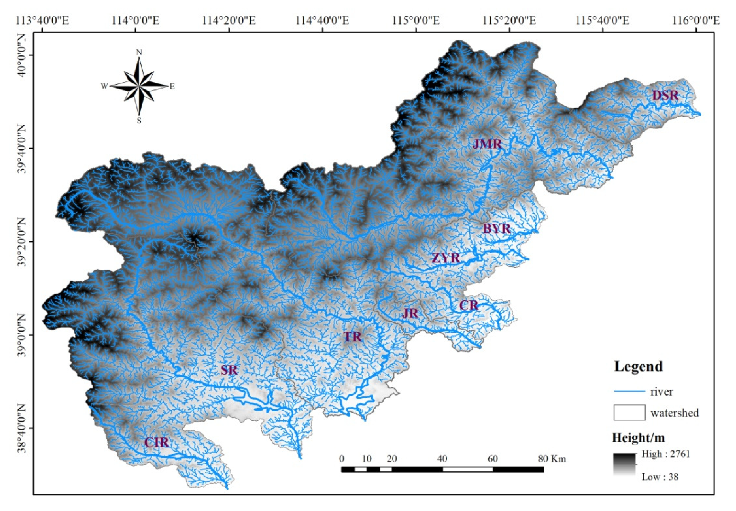
Because of the small mountainous area of the Bao River, we extracted the river network and watershed boundaries of the other nine tributaries in mountainous areas from a DEM, including the Ci River, Sha River, Tang River, Jie River, Cao River, Zhongyi River, Beiyi River, Juma River and Dashi River (Figure 2).
4.1. Watershed Geometry
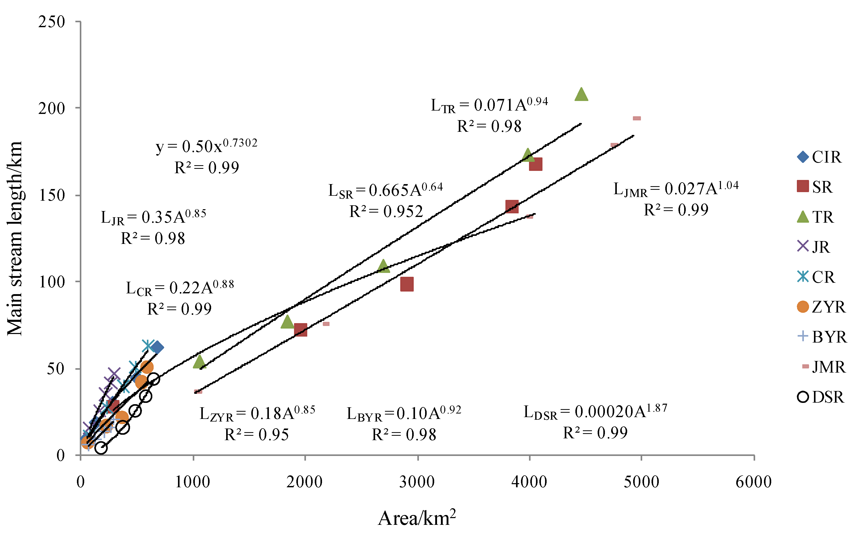
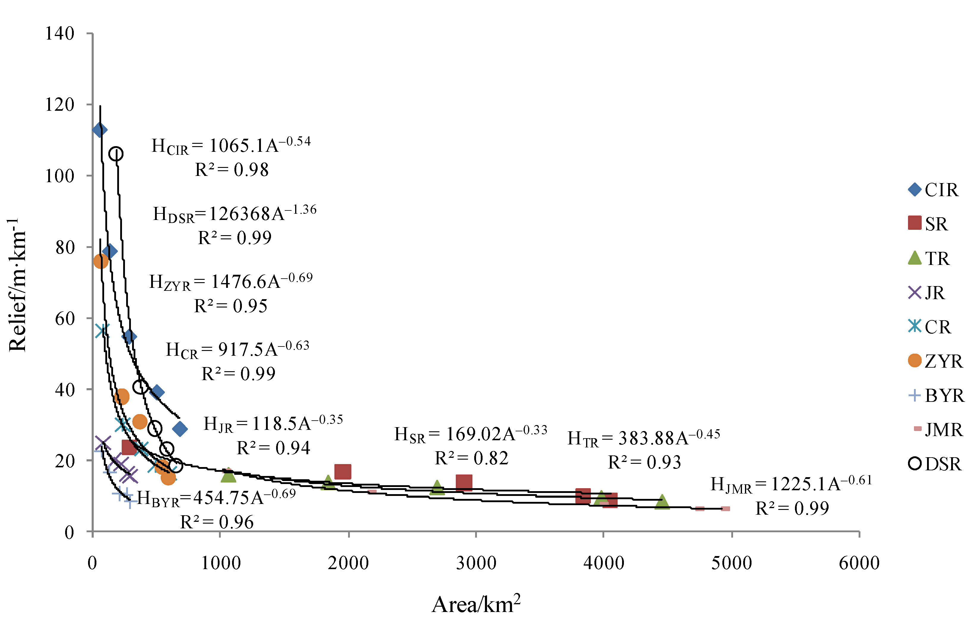
Many watershed geometry features are related to the drainage area [43].We analyzed the correlation between the main stream length (L, km) and area (A, km2) (Figure 3), relief (H, m/km) and A (Figure 4). Both relationships were power exponents, and the variation of trends were significant (L = aAb, b = 0.64–1.87, R2 = 0.95–0.99, p < 0.01; H = cAd, d = −1.36–−0.33, R2 = 0.82–0.99, p < 0.01); namely, with the increase of area, the main stream length increases and relief decreases significantly, respectively. If L was proportional to A0.5, the geometric morphology upstream was similar to that downstream [44]. As shown in Figure 3, L and A were positively correlated, but the minimum b value was 0.64, which was greater than 0.5. Therefore, we believe that the basin forms of the mountain watersheds in the Daqing River change along the channel. With the increase in basin area, the basins became longer. H and A were negatively correlated, and the relief changed more slowly with increasing basin area. From Figure 3 and Figure 4, except for the Dashi River, the b value and d value of the other eight rivers were close, which means that their basins had similar forms.
There are many indices expressing the basin shape [44], but only two parameters are widely used. They are the circularity ratio and elongation ratio (Table 1).The circularity ratio (Rc) and elongation ratio (Re) were additional parameters that were used to describe the watershed geometry morphology. If the drainage basin shape is round, the value of Rc and Re should be equal to 1 and 1.275, respectively; if the shape is square, Rc and Re should be 0.785 and 1.128. With the increase in stream length, Rc continues to decease and Re approaches zero, and the shape becomes narrower and longer [32,33]. The Rc of mountain watersheds in the Daqing River ranged from 0.14 to 0.36, and the values of Re were 0.36–0.94. We can conclude that the basin shape of the mountain watersheds in the Daqing River was narrow. According to Liu [45], the flood confluence time is short for a narrow basin. Therefore, the small basin circularity ratio of the Daqing River is favorable to the formation of high flood peaks, which easily delivered a large amount of runoff from the basins during the rainy day to the Xiongan New Area.
4.2. River Network Morphology
As mentioned above, the upper and lower reaches of the Daiqing River have distinctive landforms. In the lower reaches of the Daiqing River, there are no tributaries on both banks. Thus, the river network morphological characteristics of the upper reaches of the Daiqing River, including river bifurcation ratio and drainage density were analyzed here.
4.2.1. Stream Order
The ordering scheme proposed by Strahler [43] was used here. The bifurcation ratio Rb = Nu/Nu+1, where Nu and Nu+1 denote the number of stream segments of order u and u+1, respectively. Watersheds with different natural geographical conditions tend to have different drainage bifurcation ratios [46]. For the watersheds in flat or hilly and gully regions, the Rb is close to 2; for the watersheds in mountainous regions, it is 3–5. The Rb in the mountain area is larger than that in the plain area. The Rb grows with the development of a drainage system [44].
Strahler [43] pointed that, except for the areas with hard geological substrata, the differences of Rb between regions were small. Morisawa [47] proved that the Rb in fifteen small watersheds on the Appalachian Plateau was close to a constant. Therefore, the average drainage bifurcation ratio is the most reasonable parameter to reflect the drainage structure.
We ordered the extracted drainage network using the Strahler criterion [43]; namely, the primary finger-tip stream is the order I, and the new stream formed by the convergence of the two order I streams is the order II, and in this way, the streams in the whole basin will be ordered until the end. The channel that flows through the whole basin with the amount of water and sediment is called the highest order stream. Therefore, the stream orders of the mountain watersheds in the Daqing River ranged from five to seven. Specifically, the upper reaches of the Jie River and Beiyishui River were 5th-order streams, Ci River, Cao River and Dashi River were 6th-order streams, and the other four rivers were 7th-order streams. The average bifurcation ratio of nine rivers was calculated according to the stream order results. For mountain watersheds, the bifurcation ratio ranged from 3–4. The bifurcation ratio of areas with loose rocks, sparse vegetation, and heavy rainfall was high [46]. The average bifurcation ratio of those nine mountain watersheds was 3.8–4.8. In other words, the order of the u + 1 rivers in each basin of the Daqing River was on average 4 times larger than that of order u rivers.
4.2.2. Drainage Density
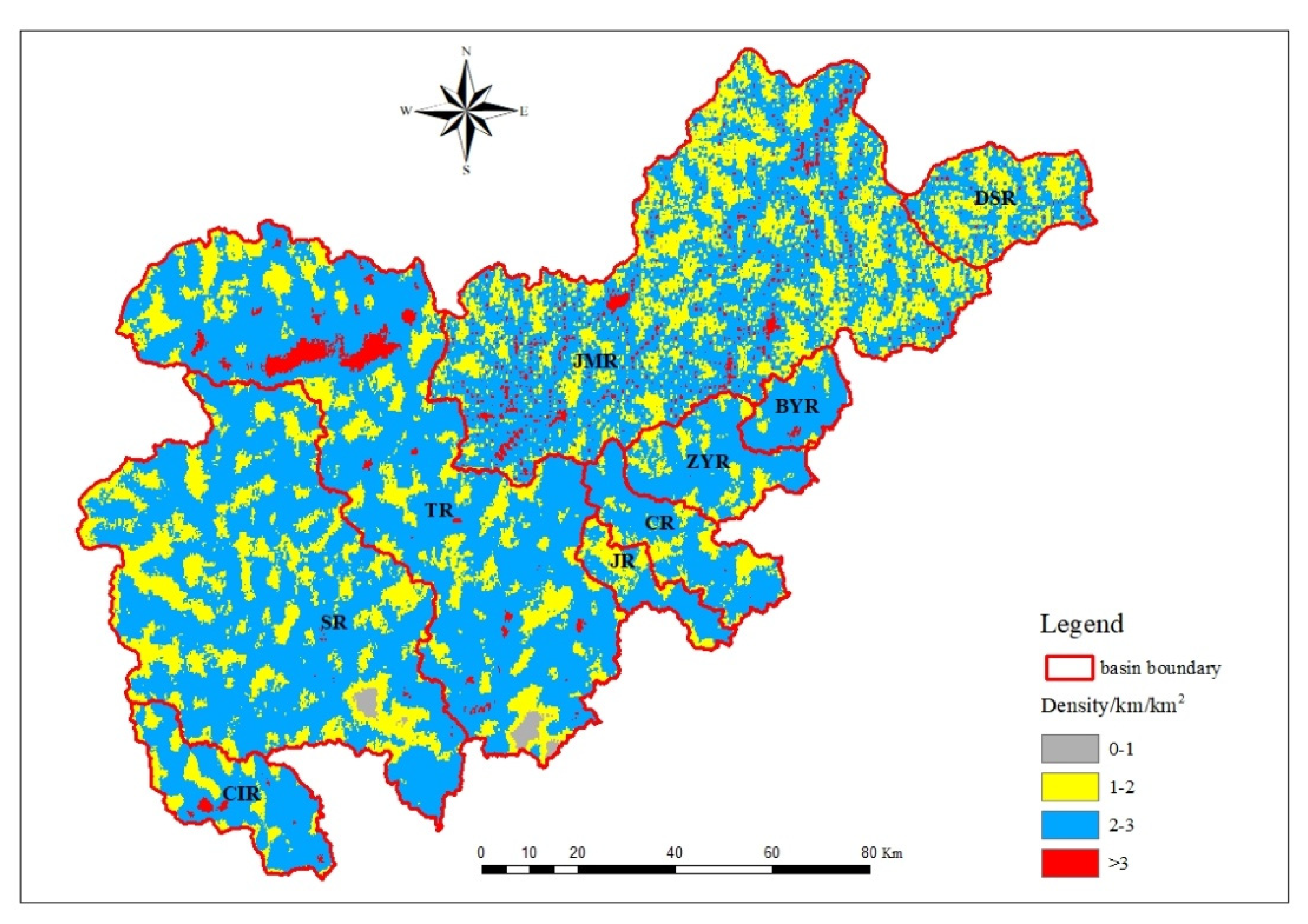
The drainage density of mountain watersheds in the Daqing River ranged from 2–2.3 km/km2, and the spatial difference was small. According to the method mentioned above, we obtained a spatially continuous distribution of drainage density (Figure 5). Dd can be divided into four areas, including 0–1 km/km2, 1–2 km/km2, 2–3 km/km2 and above 3 km/km2. For mountain watersheds in the Daqing River, Dd was mainly distributed from 1–2 km/km2 and 2–3 km/km2; specifically, the distribution areas of the southern watersheds fluctuated little, and the average distribution area of 1–2 km/km2 and 2–3 km/km2 was 71%. The 1–2 km/km2 distribution area of the Juma River and Dashi River in northern watersheds increased significantly, and the average distribution area from 2–3 km/km2 was 68%.
4.3. Relationship between Dd and Rainfall and Vegetation Cover
Collins and Bras [40] summarized the feedback of vegetation and runoff under varying mean annual precipitation levels in a schematic representation showing an initial increase in drainage density in arid areas, followed by a decrease in semiarid regions and an increase in humid environments.
We drew rainfall and Dd with SPSS as follows: Dd = −0.001xrainfall + 2.501 (R = 0.542, N = 9, p = 0.132). Rainfall is negatively correlated with drainage density, which agrees with the results of Collins and Bras [40] in semiarid regions, but the correlation between them did not show no significance at the 0.05 level. Although rainfall is the driving force behind gully development, for the small areas of mountain watersheds in the Daqing River, the average spatial variation in rainfall is not obvious.
Based on the change in NDVI in the upper reaches of each watershed in 2018, the correlation between the NVDI and drainage density was analyzed, and the correlation equation was obtained by SPSS as Dd = −0.198xNDVI + 1.227 (R = 0.738, N =9, p = 0.02). This indicated that gullies developed in places with poor vegetation cover but not in places with good vegetation cover. Of course, it is difficult to determine the causal relationship between these factors because there may be a positive feedback mechanism; that is, the development of gullies in places with poor vegetation is conducive to the development of gullies, while the development of gullies, strong erosion and soil erosion inhibit the growth of vegetation [8].
4.4. Relationship between Dd and Soil Type
Basin lithology affects the extent of landscape dissection. Some variation in Dd by lithology type was also observed; the average Dd for shale and schist was well above the observed mean Dd, whereas the values for limestone and acidic volcanic rocks were well below the mean Dd [48]. The national soil database was used to obtain the classification of surface substances in the Daqing River (according to the classification standard of FAO90). The extracted river networks in the study area were superimposed on the soil type, and the distribution of gullies on each soil type was analyzed. The drainage density of each soil type was calculated (Figure 6). There are seven types of surface materials in mountain watersheds of the Daqing River, namely, cambisols (CM), luvisols (LV), regosols (RG), fluvisols (FL), leptosols (LP), anthrosols (Atc) and gleysols (Glm). The proportional distribution area of each soil type and the percentages of sand, silt and clay are shown in Figure 6. The main soil types in the mountain watersheds of the Daqing River were CM, LV and RG, with a distribution area of 91%. These three soil types all had a high content of sand gradation, approximately 50%, followed by silt. Clay made up the lowest proportion of the soil content, at approximately 20%.
Dd was the lowest in Glm (1.15 km/km2) and the highest in FL (2.54 km/km2). For the other soil types, Dd was between 2 and 2.5 km/km2. If soil particles are coarse and the permeability of the soil is high, the soil corrosion factor K value is low [49]. Melton [50] also found that Dd decreased with soil infiltration capacity. Figure 6 shows that the coarse gradation content of FL was the highest, at 85.5%. Thus, we can explain why the Dd of FL was the largest. The ability to resist soil erosion influences Dd. In addition, although the sand content of Atc was low, the Dd as relatively high, at 2.44 km/km2. It can be concluded that soil erosion is affected not only by soil properties but also by anthropic factors.
4.5. The Drainage Density and Terrain
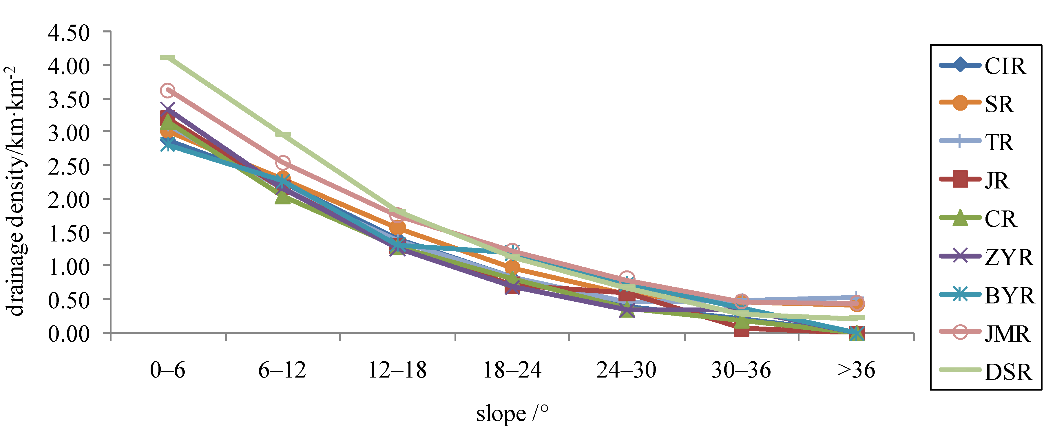
4.5.1. The Drainage Density on Different Slopes
The drainage density on different slopes is of particular interest as it helps to understand the relationship between erosion rates and patterns of channelization, which are critical for testing eco-geomorphic landscape evolution models [38,51].
Except for the maximum slope of the Juma River, which was 47°, the slopes of all other river basins were below 42°. We divided the slope into seven grades: 0–6°, 6–12°, 12–18°, 18–24°, 24–30°, 30–36° and over 36°. We calculated the distributions of gullies on different slope grades (Figure 7). The Dd in each study area decreased with increasing slope; there were no gullies with slopes higher than 36° in the Ci River, Jie River, Cao River, Zhongyi River or Beiyi River. In addition, the slopes of the Juma River and Dashi River mainly ranged from 6–18°, and the slopes in the other research areas were mainly distributed in the range from 0–12°, accounting for 62–81% of the whole mountain area. All gullies were concentrated between 0° and 12°, and the density value was above 2 km/km2. When the slope was greater than 24°, the value of Dd decreased to 0.8 km/km2 and below. The maximum Dd of all rivers was between 0 and 6°, but the value of maximum Dd was different. Dd was highest in the Dashi River (4.1 km/km2), followed by the Juma River (3.6 km/km2), and the rest of the rivers were all approximately 3.0 km/km2. The Dd values were high in the north and low in the south.
4.5.2. The Drainage Density in Different Aspect of Slopes
Aspect is an important terrain factor. Some studies have shown that the differences of rainstorms, rainfall erosivity, soil moisture and vegetation growth conditions make the soil erosion pattern and intensity in different aspects have obvious asymmetry [52]. For revealing the impacts of aspects on drainage development in the Daqing River, we divided the slope aspect into north (N), northeast (NE), east (E), southeast (SE), south (S), southwest (SW), west (W) and northwest (NW). There were differences in Dd on each aspect. The maximum Dd was 2.45 km/km2, and the minimum was 1.63 km/km2 (Figure 8). SPSS was used to compare and test the average Dd of each aspect, and they had values of 2.16 km/km2 (N), 2.08 km/km2 (NE), 2.03 km/km2 (E), 2.02 km/km2 (SE), 2.10 km/km2 (S), 2.20 km/km2 (SW), 2.16 km/km2(W) and 2.07 km/km2 (NW). In the formation process of the gullies, there was a directivity of upstream erosion, subdivision of gullies and development of branches. Relatively speaking, the gullies in the southwest, north and west developed considerably, while gullies in the east and southeast did not develop much. The measurement coefficient of the linear correlation between drainage density and aspect was 0.44, p = 0.042 < 0.05, which passed the significance test. This indicated that aspect influenced drainage density, but the two did not have a simply linear relationship. This is because the difference in aspect results in differences in other influencing factors, such as rainfall and solar radiation, and the change in vegetation growth caused by different solar radiation leads to different development and evolution of erosion gullies [52].
4.6. Indicative Significance of Dd
As shown in Figure 9, the HI values in the mountain basins of the Daqing River were all below 0.4. The correlation between HI and Dd was significant (R = 0.87, p = 0.015), but these factors were not simply linearly related. With the increase in HI, Dd first decreased and then increased. With 0.3 as the boundary, the closer HI was to 0.3, the smaller Dd was, and conversely, the larger Dd is. It was concluded that the landform of the mountain basin of the Daqing River is in an advanced stage of erosion development and that Dd will no longer increase [35].
4.7. Effect of Channel Morphology on Water Yield
The measured runoff data of the Ci River, Sha River, Tang River, Cao River, Zhongyi River, Juma River and Dashi River were analyzed. Based on SPSS, the relationship between A and the water yield modulus (Sr, 104 t/km2•a) was Sr = 5962.3/A + 7.3 (R = 0.421, N = 7, p = 0.346). The relationship between Re and Sr was Sr = −528.6Re3 + 457.5Re − 140.7 (R = 0.714, N = 7, p = 0.202). According to the above two equations, although the correlation coefficient between Sr and A and Re was not low, neither of them passed the significance level of 0.05.
The relationship between the slope of the channel (S, %) and Sr was Sr = e3.6−24.13/S (R = 0.78, N = 7, p = 0.039). There was a significant positive correlation between these factors, that is, the greater the slope was, the greater the water yield.
Drainage density is not only an important index of watershed erosion but also an important factor affecting catchment confluence and sediment transport in gullies. The relationship between Dd and Sr was Sr = 21.5 Dd − 33.27 (R = 0.214, N = 7, p = 0.645). The water yield modulus was proportional to the drainage density; that is, the water yield modulus increased as the drainage density increased. Melton [50] also observed that Dd increased with increasing percentage of bare ground and runoff, but in this region, the two were not significantly correlated.
In addition, the impacts of other factors, such as rainfall, relief, slope gradient, etc., may produce large deviations in the constructed relations between specific water yield and indices of basin geometry, so the small number of available data samples do not prove the influence of basin geometry on water yield.
5. Conclusions
Based on the DEM, which had a resolution of 30 m, we extracted the river network of nine mountain watersheds in the Daqing River. The shape of the mountain watersheds in the Daqing River was narrow. The stream orders ranged from five to seven. The average bifurcation ratio was 3.8–4.8. The drainage density was in the range from 2–2.3 km/km2, and there was low spatial variation.
Although rainfall is the driving force of gully development, for the small areas of mountain watersheds in the Daqing River, the average spatial variation of rainfall is not obvious. Rainfall was negatively correlated with drainage density, but the correlation between them was not significant at the 0.05 level. The correlation between NVDI and Dd indicated that gullies developed in places with poor vegetation cover but not in places with good vegetation cover. Dd decreased with increasing slope; it was highest in the Dashi River (4.1 km/km2), followed by the Juma River (3.6 km/km2), and the rest of the rivers had values of approximately 3.0 km/km2. Dd values were high in the north and low in the south. The gullies in the southwest, north and west developed considerably, while gullies in the east and southeast did not develop much.
With 0.3 as the boundary, the closer HI was to 0.3, the smaller drainage density was, and conversely, the larger drainage density was. The landform of mountain basins in the Daqing River was in an advanced stage of erosion development, and the drainage density is no longer increasing. In addition, there was a significant positive correlation between the channel slope and water yield modulus, and the other watershed parameters were not significantly correlated with the yield modulus.
Author Contributions
Writing—original draft preparation, H.Y.; writing—review and editing, J.C. All authors have read and agreed to the published version of the manuscript.
Funding
This research was financially supported by National Key Research and Development Plan Project of China (grant numbers2018YFC0406501-02), National Natural ScienceFoundation of China (grant numbers 41877170, 42001009) and the Natural Science Foundation of Hebei Province (grant numbers D2021503001).
Institutional Review Board Statement
Not applicable.
Informed Consent Statement
Not applicable.
Data Availability Statement
All data, models, and code generated or used during the study appear in the submitted article.
Acknowledgments
We thank the three anonymous reviewers and academic editor for their critical comments and constructivesuggestions on the manuscript.
Conflicts of Interest
The authors declare no conflict of interest.
References
- Hynes, H.B. The Ecology of Running Waters; University of Toron to Press: Toronto, ON, Canada, 1970. [Google Scholar]
- Wohl, E.E. Mountain Rivers. Water Resources Monograph 14; American Geophysical Union: Washington, DC, USA, 2000. [Google Scholar]
- Chen, Q.; Guo, B.; Zhao, C.; Zhang, J. A comprehensive ecological management approach for northern mountain rivers in China. Chemosphere 2019, 234, 25–33. [Google Scholar] [CrossRef]
- Grant, G.E.; Swanson, F.J.; Wolman, M.G. Pattern and origin of stepped-bed morphology in high-gradient streams, Western Cascades, Oregon. Geol. Soc. Am. Bull. 1990, 102, 340–352. [Google Scholar] [CrossRef]
- Wohl, E.; Kuzma, J.N.; Brown, N.E. Reach-scale channel geometry of a mountain river. Earth Surf. Proc. Land. 2004, 29, 969–981. [Google Scholar] [CrossRef]
- Fryirs, K.; Brierley, G. Antecedent controls on river character and behaviour in partly confined valley settings: Upper hunter catchment, NSW, Australia. Geomorphology 2010, 117, 106–120. [Google Scholar] [CrossRef]
- Yadav, B.; Hatfield, K. Stream network conflation with topographic DEMs. Environ. Model. Softw. 2018, 102, 241–249. [Google Scholar] [CrossRef]
- Yang, H.; Shi, C. Basin form characteristics, causes and implications of the ten kongduis in the upper reaches of the Yellow River. Quat. Int. 2017, 453, 15–23. [Google Scholar] [CrossRef]
- Horton, R.E. Drainage-basin characteristics. Trans. Am. Geophys. Union 1932, 13, 350–361. [Google Scholar] [CrossRef]
- Passalacqua, P.; Do Trung, T.; Foufoula-Georgiou, E.; Sapiro, G.; Dietrich, W.E. A geometric framework for channel network extraction from lidar: Nonlinear diffusion and geodesic paths. J. Geophys. Res. Earth Surf. 2010, 115, F01002. [Google Scholar] [CrossRef] [Green Version]
- Pelletier, J.D. A robust, two-parameter method for the extraction of drainage networks from high-resolution digital elevation models (DEMs): Evaluation using synthetic and real-world DEMs. Water Resour. Res. 2013, 49, 75–89. [Google Scholar] [CrossRef]
- Clubb, F.J.; Mudd, S.M.; Milodowski, D.T.; Hurst, M.D.; Slater, L.J. Objective extraction of channel heads from high-resolution topographic data. Water Resour. Res. 2014, 50, 4283–4304. [Google Scholar] [CrossRef] [Green Version]
- Byun, J.; Seong, Y.B. An algorithm to extract more accurate stream longitudinal profiles from unfilled DEMs. Geomorphology 2015, 242, 38–48. [Google Scholar] [CrossRef]
- Rinaldo, A.; Gatto, M.; Rodriguez-Iturbe, I. River networks as ecological corridors: A coherent ecohydrological perspective. Adv. Water Resour. 2017, 112, 27–58. [Google Scholar] [CrossRef] [PubMed]
- Zhu, G.P.; Wang, X.R.; Wang, M.; Qi, S.; Gao, J.R. Advances on near natural comprehensive control of urban river. Sci. Soil Water Conserv. 2006, 4, 92–97. [Google Scholar]
- Mikus, P.; Wyzga, B.; Walusiak, E.; Radecki-Pawlik, A.; Liro, M.; Hajdukiewicz, H.; Zawiejska, J. Island development in amountain river subjected to passive restoration: The Raba River, Polish Carpathians. Sci. Total Environ. 2019, 660, 406–420. [Google Scholar] [CrossRef] [PubMed]
- Kuemmelen, M.; Reichert, P.; Siber, R.; Schuwirth, N. Ecological assessment of river networks: From reach to catchment scale. Sci. Total Environ. 2019, 650, 1613–1627. [Google Scholar] [CrossRef] [PubMed]
- Prodanovic, P.; Simonovic, S.P. An operational model for support of integrated watershed management. Water Resour. Manag. 2010, 24, 1161–1194. [Google Scholar] [CrossRef]
- Song, C.; Ke, L.; Pan, H.; Zhan, S.; Liu, K.; Ma, R. Long-term surface water changes and driving cause in Xiong’an, China: From dense Landsat time series images and synthetic analysis. Sci. Bull. 2018, 63, 708–716. [Google Scholar] [CrossRef] [Green Version]
- Cui, B.; Li, X.; Zhang, K. Classification of hydrological conditions to assess water allocation schemes for Lake Baiyangdian in North China. J. Hydrol. 2010, 385, 247–256. [Google Scholar] [CrossRef]
- Yang, Z.; Mao, X. Wetland system network analysis for environmental flow allocations in the Baiyangdian Basin, China. Ecol. Model. 2011, 222, 3785–3794. [Google Scholar] [CrossRef]
- Wang, X.L.; Zhang, Y. Current state of water environment of Daqing River basin and countermeasures. Water Resour. Prot. 2000, 2, 33–35, (In Chinese with English abstract). [Google Scholar]
- Tian, J.; Liu, J.; Wang, J.; Li, C.; Yu, F.; Chu, Z. A spatio-temporal evaluation of the WRF physical parameterisations for numerical rainfall simulation in semi-humid and semi-arid catchments of Northern China. Atmos. Res. 2017, 191, 141–155. [Google Scholar] [CrossRef]
- Xia, J.; Zhang, Y.Y. Water resource and pollution safeguard for Xiongan New Area construction and its sustainable development. Bull. Chin. Acad. Sci. 2017, 11, 1199–1205. [Google Scholar]
- Lu, L.; Yu, Y.D.; Liu, J.H.; Qin, D.Y. Analysis of hydrologic characteristics in Haihe River Basin. Haihe River Water Conserv. 2011, 6, 1–4. (In Chinese) [Google Scholar]
- Liu, W.J.; Zhao, Z.J. Analysis of the influence of the change of hydrological characteristics of Daqing he river basin on Baiyangdian wetland. Groundwater 2012, 34, 101–102. (In Chinese) [Google Scholar]
- Yan, Y.X.; Wang, S.J.; Yan, M.; He, L.; Cheng, D.S. Spatial patterns of scale effect of specific sediment yield in Haihe River Basin. Prog. Geogr. 2014, 33, 57–64, (In Chinese with English abstract). [Google Scholar]
- Yuan, Z.J.; Sun, Q. Runoff-sediment relationship for various spatial scales in the Daqing he rocky mountainous area. Resour. Sci. 2016, 38, 750–757, (In Chinese with English abstract). [Google Scholar]
- SL665-2014. Technical Standards for Comprehensive Treatment of Water and Soil Erosion in the Earth Rock Mountain Areas of Northern China; China Water Power Press: Beijng, China, 2014.
- Whipple, K.X.; Tucker, G.E. Dynamics of the stream-power river incision model: Implications for height limits of mountain ranges, landscape response time scales, and research needs. J. Geophys. Res. 1999, 104, 17661–17674. [Google Scholar] [CrossRef]
- Chen, Y.Z.; Jing, K.; Cai, Q.G. Modern Erosion and Control in the Loess Plateau; Science Press: Beijing, China, 1988. (In Chinese) [Google Scholar]
- Miller, V.C. A Quantitative Geomorphic Study of Drainage Basin Characteristics in Clinch Mountain Area, Virginia and Tennessee; Project NR 389-042, Tech. Rept. 3; Columbia University Department of Geology, O.N.R. Geography Branch: New York, NY, USA, 1953. [Google Scholar]
- Schumm, S.A. Evolution of drainage systems and slopes in badlands at Perth Amboy, New Jersey. Geol. Soc. Am. Bull. 1956, 67, 597–646. [Google Scholar] [CrossRef]
- Burrough, P.A.; McDonnell, R.A. Principles of Geographical Information Systems; Oxford University Press: Oxford, UK, 1998. [Google Scholar]
- Strahler, A.N. Hypsometric (area-altitude) analysis of erosional topography. Geol. Soc. Am. Bull. 1952, 63, 1117–1142. [Google Scholar] [CrossRef]
- Moglen, G.E.; Eltahir, E.A.B.; Bras, R.L. On the sensitivity of drainage density to climate change. Water Resour. Res. 1998, 34, 855–862. [Google Scholar] [CrossRef] [Green Version]
- Talling, P.J.; Sowter, M.J. Drainage density on progressively tilted surfaces with different gradients, wheeler ridge, california. Earth Surf. Process. Landf. 1999, 24, 809–824. [Google Scholar] [CrossRef]
- Tucker, G.E.; Bras, R.L. Hillslope processes, drainage density, and lands cape morphology. Water Resour. Res. 1998, 36, 1953–1964. [Google Scholar] [CrossRef]
- Luoto, M. New insights into factors controlling drainage density in subarctic landscapes. Arctic. Antarct. Alpine Res. 2007, 39, 117–126. [Google Scholar] [CrossRef] [Green Version]
- Collins, D.B.G.; Bras, R.L. Climatic and ecological controls of equilibrium drainage density, relief, and channel concavity in dry lands. Water Resour. Res. 2010, 46, W04508. [Google Scholar] [CrossRef] [Green Version]
- Smith, V.B.; David, C.H.; Cardenas, M.B.; Yang, Z.-L. Climate, river network, and vegetation cover relationships across a climate gradient and their potentialfor predicting effects of decadal-scale climate change. J. Hydrol. 2013, 488, 101–109. [Google Scholar] [CrossRef]
- Chaick, O.A.; Roering, J.J.; Heimsath, A.M.; Levick, S.R.; Asner, G.P.; Khomo, L. Shaping post-orogenicl and scapes by climate and chemical weathering. Geology 2013, 41, 1171–1174. [Google Scholar] [CrossRef] [Green Version]
- Strahler, A.N. Statistical Analysis in Geomorphic Research. J. Geol. 1954, 62, 1–25. [Google Scholar] [CrossRef]
- Chien, N.; Zhang, R.; Zhou, Z.D. Fluvial Processes Study; Science Press: Beijing, China, 1987. [Google Scholar]
- Liu, R.L. The Characteristics of Water Network and Landforms of the Beisha River in Taishan Mountain; Shandong Normal University: Jinan, China, 2011; (In Chinese with English abstract). [Google Scholar]
- Hoton, R.E. Erosional development of stream sand their drainage basins; hydrophysical approach to quantitative morphology. GSA Bull. 1945, 56, 275–370. [Google Scholar] [CrossRef] [Green Version]
- Morisawa, M.E. Quantitative geomorphology of some watersheds in the Appalachian Plateau. Geol. Soc. Am. Bull. 1962, 73, 1025–1046. [Google Scholar] [CrossRef]
- Sangireddy, H.; Carothers, R.A.; Stark, C.P.; Passalacqua, P. Controls of climate, topography, vegetation, and lithology on drain age density extracted from high resolution to pography data. J. Hydrol. 2016, 537, 271–282. [Google Scholar] [CrossRef] [Green Version]
- Wu, Q.F.; Zhang, H.J. Soil Erosion; Science Press: Beijing, China, 2012. [Google Scholar]
- Meton, M.A. An Analysis of the Relations Among Elements of Climate, Surface Properties, and Geomorphology; Technical Report 11; Office of Naval Research, Department of Geology, Columbia University: New York, NY, USA, 1957. [Google Scholar]
- Ochi, T. Drainage density and relative relief in humid steep mountains with frequent slope failure. Earth Surf. Process. Landf. 1997, 22, 107–120. [Google Scholar] [CrossRef]
- Chen, H.; Fang, H.Y.; Cai, Q.G.; Lei, T.W.; Liang, G.L. Comparison of different aspect of erosion evolvement in the loess hilly area: A case study of Wangjiagou Rinaldo catchment of western Shanxi province. Resour. Sci. 2006, 28, 176–184, (In Chinese with English abstract). [Google Scholar]
Figure 1.
Schematic diagram of Daqing River basin.

Figure 2.
Watersheds of the mountainous areas in the Daqing River generated from a DEM (rivers are shown by abbreviated names: CIR—Ci River, SR—Sha River, TR—Tang River, JR—Jie River, CR—Cao River, ZYR—Zhongyi River, BYR—Beiyi River, JMR—Juma River and DSR—Dashi River).
Figure 2.
Watersheds of the mountainous areas in the Daqing River generated from a DEM (rivers are shown by abbreviated names: CIR—Ci River, SR—Sha River, TR—Tang River, JR—Jie River, CR—Cao River, ZYR—Zhongyi River, BYR—Beiyi River, JMR—Juma River and DSR—Dashi River).

Figure 3.
Correlation of the main stream length and area of mountain watersheds in the Daqing River. (referring to Figure 2 for the abbreviated names of rivers).
Figure 3.
Correlation of the main stream length and area of mountain watersheds in the Daqing River. (referring to Figure 2 for the abbreviated names of rivers).

Figure 4.
Correlation of relief and area of mountain watershed in Daqing River. (referring to Figure 2 for the abbreviated names of rivers).
Figure 4.
Correlation of relief and area of mountain watershed in Daqing River. (referring to Figure 2 for the abbreviated names of rivers).

Figure 5.
Spatial distribution of drainage density in mountain watersheds of the Daqing River (referring to Figure 2 for the abbreviated names of rivers).
Figure 5.
Spatial distribution of drainage density in mountain watersheds of the Daqing River (referring to Figure 2 for the abbreviated names of rivers).

Figure 6.
Drainage density of different soil types in mountain watersheds of the Daqing River (soil types are shown by abbreviated names: CM—cambisols, LV—luvisols, RG—regosols, FL—fluvisols, LP—leptosols, Atc—anthrosols and Glm—gleysols).
Figure 6.
Drainage density of different soil types in mountain watersheds of the Daqing River (soil types are shown by abbreviated names: CM—cambisols, LV—luvisols, RG—regosols, FL—fluvisols, LP—leptosols, Atc—anthrosols and Glm—gleysols).

Figure 7.
Distribution of drainage densities in different slopes of mountain watersheds in the Daqing River (referring to Figure 2 for the abbreviated names of rivers).
Figure 7.
Distribution of drainage densities in different slopes of mountain watersheds in the Daqing River (referring to Figure 2 for the abbreviated names of rivers).

Figure 8.
Distribution of drainage densities in different aspects of mountain watersheds in the Daqing River (referring to Figure 2 for the abbreviated names of rivers).
Figure 8.
Distribution of drainage densities in different aspects of mountain watersheds in the Daqing River (referring to Figure 2 for the abbreviated names of rivers).

Figure 9.
Correlation between the Dd and HI values of mountain watersheds in the Daqing River.


Table 1.
Detailed meaning and calculation method of morphological feature parameters in the Daqing River.
Table 1.
Detailed meaning and calculation method of morphological feature parameters in the Daqing River.
| Parameters | Symbol and Definition | Unit | Reference |
|---|---|---|---|
| Drainage area | A | km2 | |
| Main stream length | L | km | |
| Drainage perimeter | P | km | |
| Circularity ratio | Rc = 4πA/P2 | / | [32] |
| Elongation ratio | Re = 2(A/π)1/2/L | / | [33] |
| Relief | H | m/km | |
| Total stream length | ∑L | km | |
| Drainage density | Dd = ∑L/A | km/km2 | [9] |
Publisher’s Note: MDPI stays neutral with regard to jurisdictional claims in published maps and institutional affiliations. |
© 2021 by the authors. Licensee MDPI, Basel, Switzerland. This article is an open access article distributed under the terms and conditions of the Creative Commons Attribution (CC BY) license (https://creativecommons.org/licenses/by/4.0/).
Share and Cite
MDPI and ACS Style
Yang, H.; Cao, J. Analysis of Basin Morphologic Characteristics and Their Influence on the Water Yield of Mountain Watersheds Upstream of the Xiongan New Area, North China. Water 2021, 13, 2903. https://doi.org/10.3390/w13202903
AMA Style
Yang H, Cao J. Analysis of Basin Morphologic Characteristics and Their Influence on the Water Yield of Mountain Watersheds Upstream of the Xiongan New Area, North China. Water. 2021; 13(20):2903. https://doi.org/10.3390/w13202903
Chicago/Turabian StyleYang, Hui, and Jiansheng Cao. 2021. "Analysis of Basin Morphologic Characteristics and Their Influence on the Water Yield of Mountain Watersheds Upstream of the Xiongan New Area, North China" Water 13, no. 20: 2903. https://doi.org/10.3390/w13202903
Note that from the first issue of 2016, this journal uses article numbers instead of page numbers. See further details here.