
A Characterization of the Hydrochemistry and Main Controlling Factors of Lakes in the Badain Jaran Desert, China

1
Key Laboratory of Ecohydrology of Inland River Basin, Northwest Institute of Eco-Environment and Resources, Chinese Academy of Sciences (CAS)/Alxa Desert Eco-Hydrological Experimental Research Station, Lanzhou 730000, China
2
University of Chinese Academy of Sciences, Beijing 100049, China
*
Author to whom correspondence should be addressed.
Water 2021, 13(20), 2931; https://doi.org/10.3390/w13202931
Submission received: 13 September 2021
/
Revised: 8 October 2021
/
Accepted: 17 October 2021
/
Published: 19 October 2021
(This article belongs to the Special Issue Soil Hydrological Processes in Desert Regions)
Abstract
:Badain Jaran Desert, the coexistence of dunes and lakes, and the presence of the world’s tallest dunes, has attracted worldwide attention among hydrologists. Freshwater, brackish, and saline lakes coexistence in the Badain Jaran Desert under extremely arid environmental conditions. This raises the question of why diverse lake water types exist under the same climatic conditions. Answering this question requires the characterization of lake hydrochemistry and the main controlling factors. The purpose of the presented research was to systematically analyzed samples from 80 lakes using statistical analysis, correlation analysis and hydrogeochemical methods to investigate the hydrochemical status and evolution of lakes in the Badain Jaran Desert. The results showed that the lake water in Badain Jaran Desert is generally alkaline, with the average pH and TDS were 9.31 and 165.12 g L−1, respectively. The main cations to be Na+ and K+, whereas the main anions are Cl− and SO42−. HCO3− and CO32− decreased and SO42− and Cl− increased from southeast to northwest, whereas lake hydrochemistry changed from the SO42−-Cl−-HCO3− type to the SO42−-Cl− type and lakes transitioned from freshwater to saline. The freshwater and slightly brackish lakes are mainly distributed in the piedmont area at a high altitude near the Yabulai Moutains, whereas saline lakes are mainly distributed in the desert hinterland at a low altitude, and there is a roughly increasing trend of ions from the Yabulai Mountains. The evaporation-crystallization reactions are the dominant in the study region. Moreover, some saline mineral deposits, are extensive in these regions caused by intense evaporation-crystallization.
1. Introduction
The hydrochemistry of lake water determines its suitability for utilization in fisheries, agricultural irrigation, reed production, and salt manufacture [1]. Arid areas tend to have fragile ecological environments, characterized by scarce precipitation, intense evaporation, sparse vegetation, intense desertification, and soil erosion [2,3]. Lakes in arid regions play an important role in maintaining water resources, biodiversity, and the ecological environment. However, climate droughts and intense evaporation have resulted in the loss of water quality and quantity of lake water in desert areas, thereby reducing the potential for lake development [4].
As one of the integrated geographical units of the earth’s surface, lakes are typical sites for gathering information about human activities and climate change [5]. Lake hydrochemical characteristics reflect the natural environment of the lake to some extent. Therefore, the analysis of the chemical composition of lake water is helpful to reveal water cycle processe and water-rock interactions of the leaching and evaporation of upstream rivers [6,7]. The hydrochemical characteristics of a lake can also act as an indicator of groundwater recharge and the main routes for the transport of solutes. Since the evolution of lakes in a region determines the harmony between water resources and the ecological environment, this topic has received wide attention [8,9,10].
The typical lakes of the arid area of the Badain Jaran Desert act to facilitate the exchange of material and energy and form an important component of the hydrological cycle [11,12,13,14]. In this region, the annual average precipitation is less than 100 mm but the evaporation rate is more than 3000 mm [15]. However, there are still over 100 permanent lakes in this extremely arid region, which vary considerably in size and hydrochemical characteristics, forming a unique megadune-lake land-scape [16,17]. In recent years, the area and quantity of lakes are decreasing. Saline marsh lakes formed by the shrinkage of lakes through evaporation are distributed in the hinterland and southeast margin of the desert [18]. These lakes, which range from fresh water to saline water, have a crucial contribution in mainating the fragile ecological balance in the desert, have become a key area of Quaternary geology [17,19,20,21,22] and lake hydrology research [7,8,9,10,23,24].
In the recent decades, the research on Badain Jaran Desert have primarily focused on the recharge of the lakes [9,11,25,26], but their hydrochemical and hydrological implications are not fully understood. As contributons from each hydrochemical source vary significantly in time and space [27], studying hydrochemistry in natural waters can provide important information about environmental change [22,28]; illustrate the complex interactions between biological, chemical, and physical subsystems in a limited area [29]; and explain the formation and evolution of water bodies using qualitative and quantitative methods [30]. Previous studies have had limited samples because of the harsh conditions, they could not exhaustively reflect the composition and distribution of the hydrochemistry of lakes in the Badain Jaran Desert. In this study, water samples from 80 lakes with different salinities in the Badain Jaran Desert were collected to comparatively study the hydrochemical characteristics and the mechanisms contributing to the hydrochemistry. Compared to the previous sampling, the present study greatly increased the catchment area and salinity range of the lakes. The objectives of the present study were to: (1) understand the hydrochemical characteristics of different types of lakes in the Badain Jaran Desert; (2) clarify the mechanisms driving evolution of different types of lakes in the Badain Jaran Desert.
2. Materials and Methods
2.1. Study Area
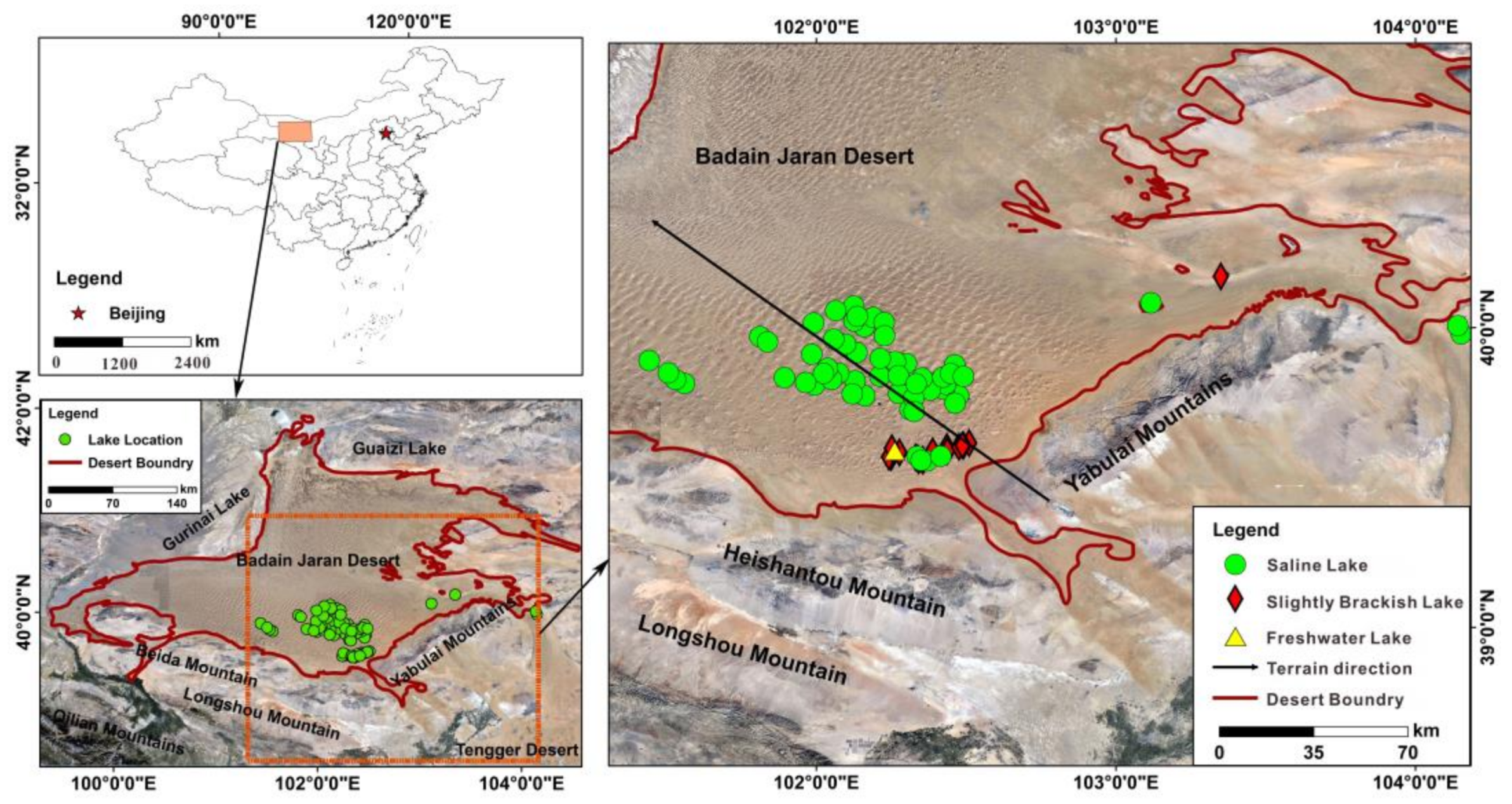
The Badain Jaran Desert (39.07–42.21° N, 99.39–104.57° E) is in the western part of the Inner Mongolia Autonomous Region of China, covering an area of 5.2 × 10⁴ km2. More specifically, the desert is east of Gurinai, south of Guaizi Lake, west of the Zongnai and Yabulai mountains, and north of Beida Mountain (Figure 1) [31]. The terrain of the desert is generally high in the south and east and low in the north and west. More specifically, elevation is higher in the Zongnai and Yabulai mountains in the east (1300–2200 m above sea level) and the Beida Mountain in the south (1800–2300 m above sea level), but gradually declines to the west and north, respectively, dropping to 970–1200 m at Guaizi Lake and east Gobi [32]. In terms of geological structure, the desert falls in the depression basin of the Alxa block. The crust has descended since the Pleistocene, thick layered Quaternary sediments have accumulated, and the surrounding mountains have strongly denuded to form a quasi-plain landform.
The study area belongs to the temperate continental desert steppe climate zone. The average annual rainfall decreases from 120 mm in the southeast to < 40 mm in the northwest and over half of annual rainfall falls between July and August. The potential evaporation of the lake surface can reach 1200–1550 mm [33]. There are neither rivers discharging into the lakes nor out lets draining them. The groundwater in the lake distribution area in the desert hinterland mainly occurs in the Pleistocene lacustrine sand bed. The water-resisting floor and roof comprise Tertiary argillaceous clastic rock and lacustrine sub-sandy soil and sub-clay, respectively, forming an artesian basin with a multi-layer structure. The burial depth of the water-resisting roof can be between 5–20 m and the thickness of the aquifer exceeds 30 m. The water-resisting layer in the lake area on the southern margin of the desert was formed by Cretaceous clastic rock. The aquifer is composed of Holocene lacustrine sand, sub-sand, and aeolian sand. The buried depth of the groundwater level is 1–2 m [11,34].
2.2. Study Design
In June 2019, water was sampled randomly from 80 lakes in the Badain Jaran Desert. White, high-density polyethylene (HDPE) samples bottles of volume 250 mL were sterilished in the laboratory. In the field, a multi-parameter water quality analyzer (U-53, HORIBA, JP) was used to measure water temperature, pH, total dissolved solids (TDS), salinity, conductivity (EC), redox potential (ORP), dissolved oxygen (DO), and specific gravity of seawater. A handheld global positioning system (GPSMAP 669s, GRMN, Taiwan, CHN) was used to record longitude, latitude, and elevation of sampling sites. The HDPE bottles were preinsed with the water samples three times prior to sampling. Then, each sample was collected from 0.3 to 0.5 m depth below the lake surface, filtered immediately through a 0.45 μm nylon filter, and finally stored in the precleaned HDPE bottles. The collected water samples were refrigerated at approximately 4 °C and later transported to the Laboratory of Soil and Water Chemistry, Key Laboratory of Ecohydrology of Inland River Basins, Chinese Academy of Sciences for analysis. Ca2+ and Mg2+ were determined by ethylenediaminetetraacetic acid (EDTA) titration. Na+ and K+ were determined by flame atomic absorption spectrophotometry. CO32− and HCO3− were neutralized by double indicator titration. Cl− and SO42− were determined by mercury nitrate titration and EDTA indirect complexation titration, respectively. The limit of detection for each ion index was 0.05 mg L−1. The reliability of all water sample data were tested by cation and anion balance test, The error in the balance between cations and anions in water can be calculated with the following formula:
where E represents relative error (%) and Nc and Na represent the mg equivalent (meq) concentrations of cations and anions, respectively (meq L−1). The absolute value of the error in the balance between anions and cations is less than 5% for reliable data. The assessment using Equation (1) indicated that E ranged between −4.05–4.76%, indicating that data of all lake water samples were reliable.
2.3. Data Processing Method
The spatial location and topography of the water sample points were performed using ArcGIS 10.2. Statistical analysis and correlation analysis of lake hydrochemical parameters were performed using SPSS 16.0, including maximum value, minimum value, average value, standard deviation, coefficient of variation, kurtosis and skewness. A Piper plot was produced using Aqua TEChem 2014.2 to analyze the hydrochemical types of lake water. The ions interrelationships and the Gibbs diagram used to analyze the hydrochemical changes in lake were plotted using SigmaPlot 12.5 software. Visual Minteq 3.0 is used to calculate the saturation index (SI) of the main minerals in the study area.
The salinity status of lake water can be categorized according to TDS: (1) freshwater lake (TDS < 1 g L−1); (2) slightly brackish lake (TDS between 1–24 g L−1); (3) brackish lake (TDS between 24–35 g L−1) and; (4) saline lake (TDS > 35 g L−1) [35]. Figure 1 shows the distribution of sampling points from 80 lakes in the study area.
3. Results
3.1. Hydrochemical Characteristics of Lakes in the Badain Jaran Desert
The results according to TDS of water samples indicated that freshwater, slightly brackish, brackish, and saline water lakes accounted for 1.25% (one lake), 25% (20 lakes), 0.0% (zero lakes), and 73.75% (59 lakes), respectively. The pH of water samples from 80 lakes varies between 7.54 and 10.52, the average of freshwater, brackish, and saline lakes was 7.93, 8.47 ± 0.75, 9.60 ± 0.58, respectively, indicating that the lakes were overall alkaline. The TDS of freshwater, brackish, and saline lakes is 0.88 g L−1, 6.76 ± 7.57 g L−1, 221.54 ± 137.96 g L−1, respectively. All the lakes also contained high concentrations of Na+ (0.09–295.48 g L−1) and K+ (0.01–73.97 g L−1), but the concentrations of Ca2+ (0.01–1.21 g L−1) and Mg2+ (0.02–7.13 g L−1) were very low. The main anions in the lake water were Cl− (0.15–169.83 g L−1) and SO42− (0.31–110.05 g L−1) and in most samples, the concentration of Cl− was higher than that of SO42−. Carbonate (0.02–31.37 g L−1) and bicarbonate (0.15–60.33 g L−1) were relatively low in the lakes.
The rankings of cations and anions ions according to average concentration were Na+ > K+ > Mg2+ > Ca2+ and Cl− > SO42− > HCO3− > CO32−, respectively. The anion and cation found in the highest concentrations in the freshwater lakes were Na+ and SO42−, respectively. The cations and anions found in the highest concentrations in the slightly brackish and saline lakes were Na+ and Cl−, respectively. High standard deviation (SD) values and differences between maximum and minimum values with regard to cations and anions indicate that the hydrochemical compositions of the lakes included in this study vary significantly. Except pH the other lake variables exhibited high variabilities in both slightly brackish and saline lakes. Kurtosis values in slightly brackish lakes are all less than zero except Mg2+, while skewness values are all greater than zero except Ca2+. Kurtosis values in saline lake were all greater than zero except HCO3−, and skewness values were all greater than zero except PH (Table 1).
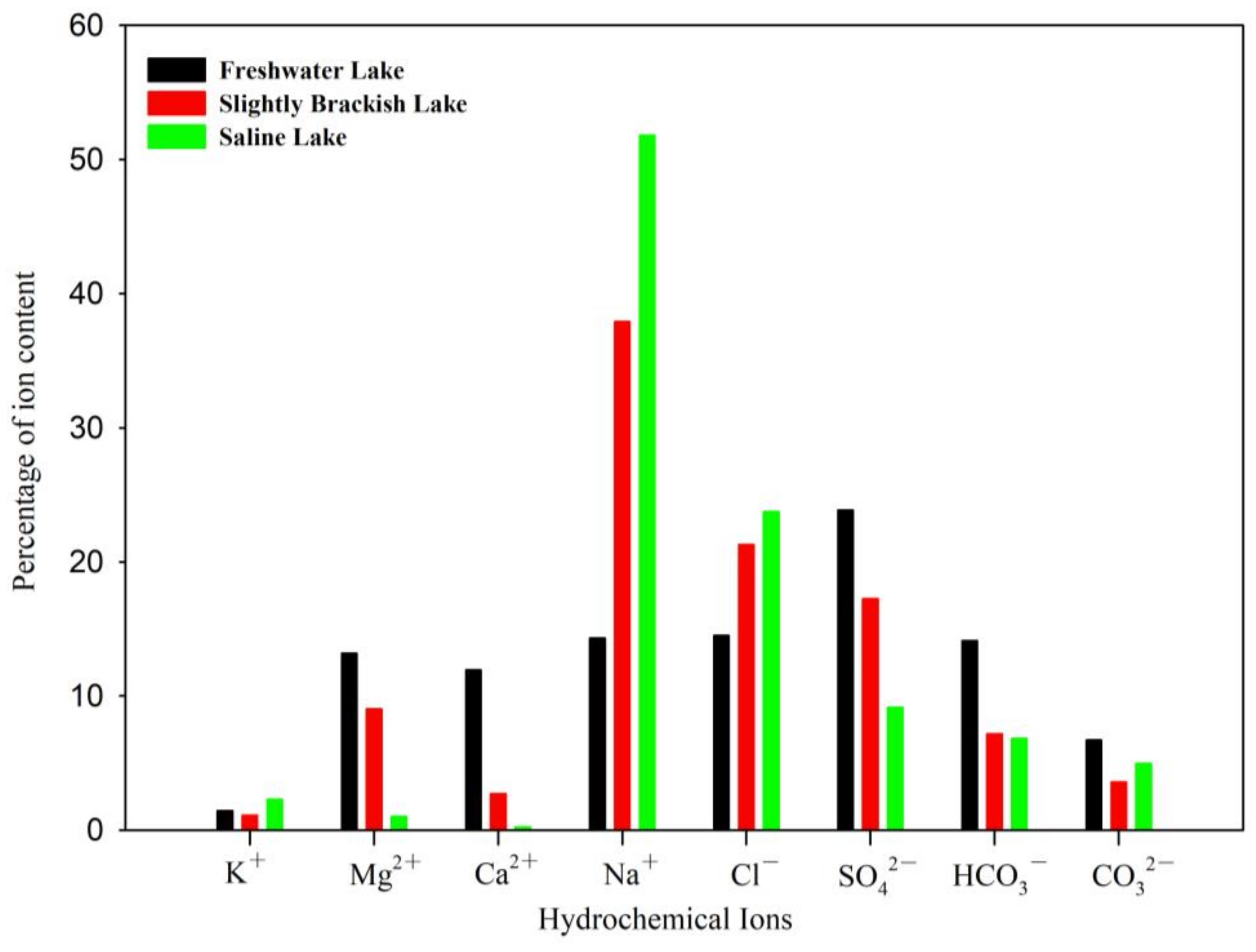
The absolute content of each ion increases from freshwater lakes to saline lakes in the Badanjaran Desert. However, the relative content of ions in different lake types is varied. The meq of Na+ and Cl− in saline lakes were higher than that in brackish lake, and lowest in freshwater lake. Na+ increased significantly with the transition from freshwater to saline lakes, accounting for 14%, 38%, and 52% of total ions in freshwater, slightly brackish, and saline lakes, respectively. The meq of SO42−, HCO3−, Ca2+, and Mg2+ showed decreasing trends as transition from freshwater lakes to saline lakes. The relative contents of Ca2+ and Mg2+ were higher in freshwater lakes and slightly brackish lakes, but lower in saline lakes. The meq of Ca2+ decreased from 12% in freshwater lakes to 3% in slightly brackish lakes and to only 0.22% in saline lakes. The meq of Mg2+ decreased from 13% in freshwater lakes to 9% in slightly brackish lakes and only 0.97% in saline lakes (Figure 2).
3.2. Hydrochemical Compositions and Types in the Badain Jaran Desert Lakes
The geochemistry of the water samples from the studied lakes was analyzed by plotting the concentrations of major cations and anions in the Piper-trilinear diagram (Figure 3), In the 80 studied desert lakes, except freshwater lake, the concentrations of Na+ and K+ were higher than those of Ca2+ and Mg2+ except freshwater lake, hence all the points were plotted in the lower right part of the diamond. The concentration of Cl− + SO42− in saline lake was higher than CO32− + HCO3−, but not significant in brackish lakes. The only one sample of the freshwater lake was classified as one group, located at the middle of the diamond in the piper diagram.
The hydrochemical type in slightly brackish lake changed from Na-SO4-Cl-HCO3 to Na-Cl-SO4. The hydrochemical types in saline lakes changed from the Na-Cl-HCO3 and Na-Cl-SO4 types to the Na-Cl type. In general, water sample contents of HCO3− and CO32− decreased and SO42− and Cl− increased from southeast to northwest of the Badain Jaran Desert. The hydrochemistry transitioned from the SO4-Cl-HCO3 type to the SO4-Cl type. As freshwater lakes transition to saline lakes, the hydrochemistry type transition from a carbonate type to the sulfate type to the chloride type.
3.3. Mechanisms Controlling Hydrochemical Component
3.3.1. Rock Weathering, Evaporation, and Soil-Leaching
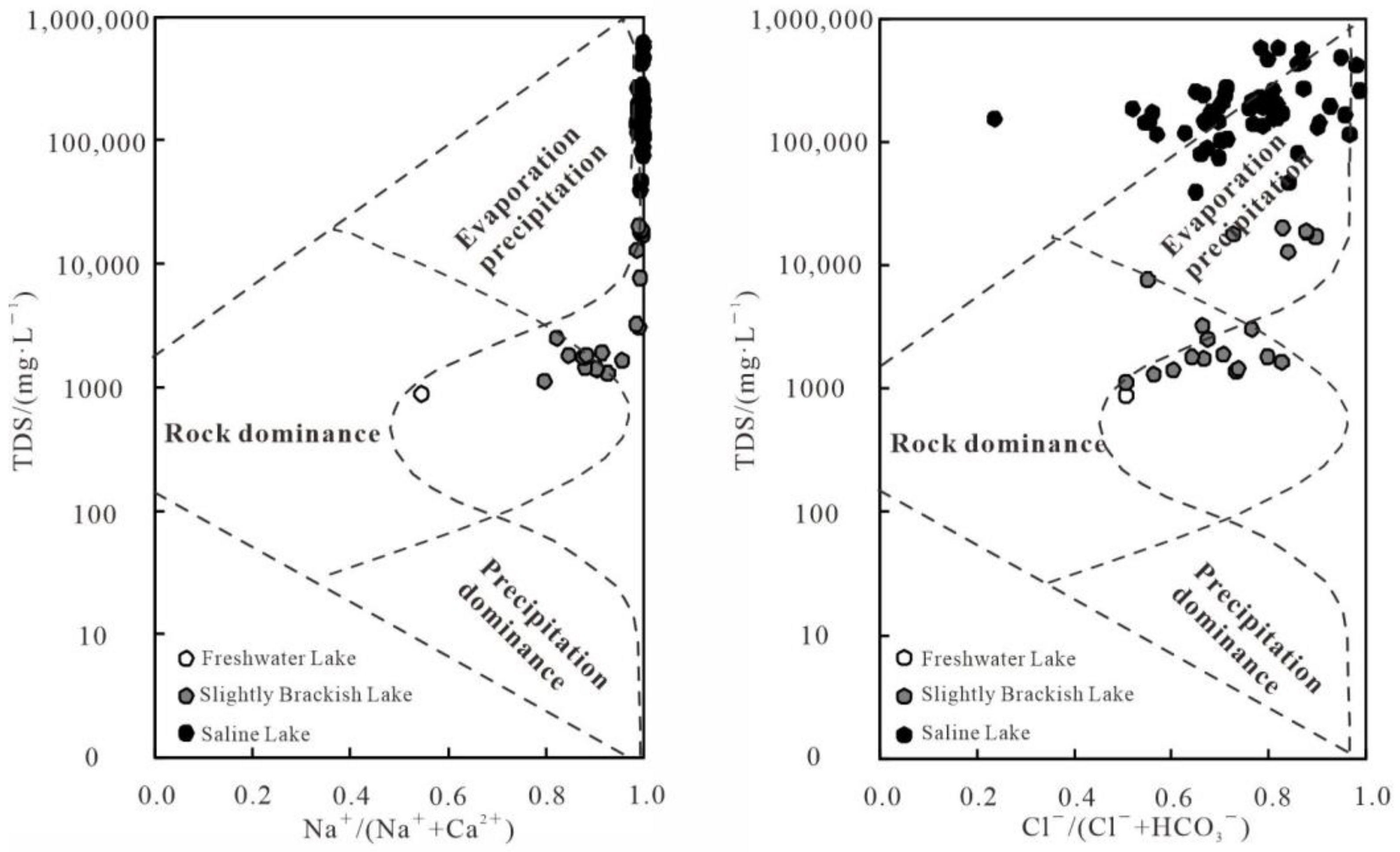
The dominant geochemical processes of the lakes water were evaporation-crystallization, precipition dominance, and rock dominance processes in the Badain Jaran Desert (Figure 4). As shown in the Gibbs diagram that the water samples taken from freshwater and slightly brackish lakes were characterized by moderate to high ratios of Na+/(Na+ + Ca2+) and Cl−/(Cl− + HCO3−), indicating that evaporation-crystallization processes and rock weathering control the hydrochemical components in these regions. However, water samples from saline lakes are characterized by high concentrations of TDS and high ratios of Na+/(Na+ + Ca2+) and Cl−/(Cl− + HCO3−), which indicate that the water is generally dominated by products of evaporation-crystallization processes. The lake water in saline lakes evaporated more intensively than in the other lakes. The ratios of Na+/(Na+ + Ca2+) in the slightly brackish lakes were more than 0.8, and that in saline lakes were close to 1.0. The ratios of Cl−/(Cl− + HCO3−) in the slightly brackish lakes ranged between 0.5–0.9, and that in saline lakes ranged between 0.5–1.0.
3.3.2. Ion Exchange
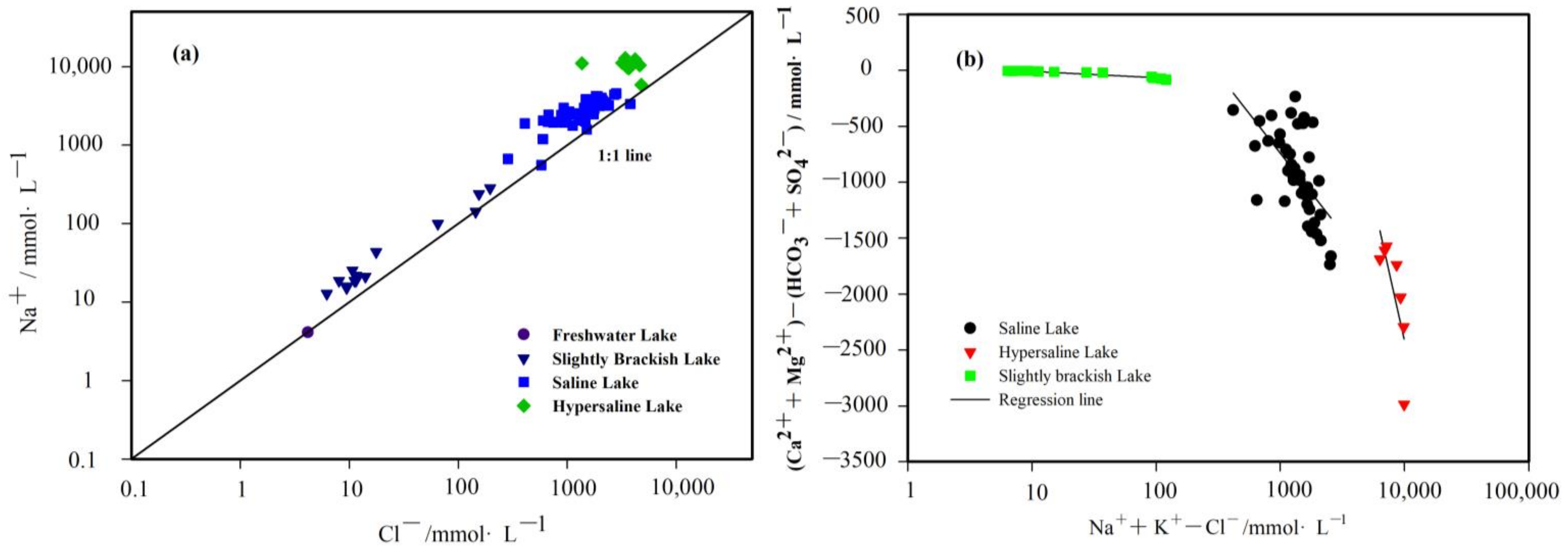
Cation exchange is an important hydrogeochemical process as it modified the hydrochemical composition of groundwater and surface water. As shown in Figure 5a, the concentrations of Na+ in most water samples from the slightly brackish lakes and saline lakes are scattered above the 1:1 line, indicating that the concentration of Na+ in water samples exceeded that of Cl−. SI for halite (−11.36–3.22) indicates an intensive dissolution or precipitation of secondary halite, which appears to be the cause of the high Na+ content. Cl− is a conserved element and is independent of other ions, Cl− does not readily reach saturation and is relatively stable. Therefore, evaporative concentration results in Cl− enrichment of desert lake water. The rate of Na+ enrichment exceeded that of Cl−, indicating strong evaporation concentration and cation exchange. Na+ is derived not only from the multiple interactions of water in the recharge aquifer and water karst leaching, but also from cation exchange with silicate mineral Ca2+ (Mg2+). We also compared the relationship between (Ca2+ + Mg2+) − (HCO3− + SO42−) and Na+ + K+ − Cl− (mmol L−1) and found (Ca2+ + Mg2+) − (HCO3− + SO42−) are negatively correlated with Na+ + K+ − Cl− (Figure 5b). We found different correlations when the content of Na+ in saline lakes was particularely high, so we separated seven samples from the group of hypersaline lakes and analysised them separately. The cation exchange processes are reversible, and the direction depends on the paticipating cations present in the waters and their concentrations. Therefore, we infer that the waters from the lakes have been undergoing netagive cation exchange (Na+ → Ca2+, Mg2+) caused by the higher concentration of Na+. Compared with saline lake, hypersaline lake has a higher degree of nagative correlation, and silghtly brackish lake has a lower degree.
3.3.3. Precipitation and Dissolution
The saturation index (SI) is an important index used to assess the degree of saturation of minerals. SI > 0 indicates deposition crystallization, whereas SI < 0 indicates mineral dissolution. Most of the SI values for anhydrite, gypsum, halite, epsomite, mirabilite, and thenardite are less than zero (Table 2), which indicates that these minerals remain undersaturated and have been dissolving. The dissolution of anhydrite, gypsum, halite, epsomite, mirabilite, and thenardite will increase the concentrations of Na+ and SO42− as time goes on. The dissolution of these mineral in the study area according to the following chemical reactions:
However, most SI values for calcite, dolomite, magnesite, and aragonite are more than zero, which indicates that these minerals are supersaturated and have been precipitation. The precipitation of dolomite, calcite, and aragonite can decrease the concentrations of Ca2+, Mg2+, and HCO3−. The dissolution of these mineral in the study area according to the following chemical reactions:
There was a strong linear relationship between the concentrations of Na+ + Cl− ions and the saturation index of halite in all lakes, even more significant in hypersaline lake, indicating that the irons in water remains in an unsaturated state and that the dissolution of halite is a continuous process (Figure 6a). The relationship between Gypsum Saturation Index and Ca2+ + SO42− is not obvious in slightly brackish lake, but linear in Saline Lake, and more obvious in hypersaline Lake (Figure 6b).
4. Discussion
4.1. Variation in Hydrochemical Composition between Lakes of Different Types
The results of the present study characterized lake water of the Badain Jaran Desert as alkaline with a high TDS. This can be mainly attributed to the closed nature of lakes in the desert, with no inflowing or outflowing surface runoff and the only lake inputs being groundwater and precipitation recharge. The process of groundwater replenishment of lake water contributes to the input of not only salt, but also leaching and cation exchange with the existing environment. The process of evaporative concentration continuously enriches the salt content of the lakes, resulting in a gradual increase in TDS content and the transition of lakes to alkaline salt lakes.
In this study, we found that different types of lakes have different chemical compositions. There is little differences among the ion components in the freshwater lake. The content of cation Na+, Ca2+, Mg2+ were high and K+ was low, while the content of anions shows the chararteristics of high SO42− and low CO32−. The only freshwater lake in the survey, Dundejilin, had a TDS of 0.88 g/L−1, lower than that measured by Shao [36] of 3.28 g/L−1. The lower current TDS content of freshwater lake indicates that the lake have received large volumes of freshwater and have experienced a rapid discharge rate over an extended period of time. In addition, the lakes have been only weakly affected by rock dominance, evaporation, and crystallization.In slightly brackish lake, Na+, Cl− and SO42− were hige, but K+, Ca2+ and CO32− were low. It is noteworthy that the coefficients of variation (CV) value for Na+, K+, Cl−, and SO42− are very high, suggesting a large varibility of the concentration. The CV values in sligtly brackish lake were higher than that of in saline lake, indicating that hydrochemical ions are more sensitive to hydrogeological conditions, topography, hydrometeorology, and other external environmental factors in slightly brackish lake. Large coefficients of variation were noted for K+ and Mg2+ in saline lakes, reflecting the strong effects of dissolution of minerals, the reaction between water and gypsum minerals, and cation exchange. The study area is characterized by low precipitation and high evaporation [37], precipitation has been considered a minor hydrochemical source compared to soil wearthing [38,39]. The ion concentrations, especially Na+ are significantly higher than Cl−, in saline lakes are more pronounced than in slightly brackish lakes. We therefore in fer that contributions from precipitation to lake hydrochemical compositions are lower in the saline lakes than in other lakes. As for chloride, it is more likely to dissolve from evaporates and be influenced by evaporation processes [40] because it only comes from precipitation. It is often used as a consercative reference element to study water- rock interactions because it undergoes few chemical and biological reactons in the natural environment [41]. A ratio of Na/Cl greater than 1 indicates that in addition of evaporation, minerral dissolution and cation exchange are taking place in the region.
The Badain Jaran Desert shows complex lake hydrochemical types. Most of the lakes show different hydrochemical types, even under similar hydroclimatic conditions. This phenomenon indicates a diversification of lake water sources. HCO3− and CO32− in lake water decrease from southeast to northwest, whereas SO42− and Cl− increase, and the lake water hydrochemical type transitions from SO4-Cl-HCO3 to SO4-Cl. As lakes transition from freshwater to saline lakes, their hydrochemical types transition from the carbonate type to the sulfate type to the chloride type. Water samples of different types of lakes are affected by evaporative-crystallization, and the continuous accumulation of irons results in Ca2+ and HCO3− forming insoluble irons which precipitates as well as the accumulation of soluble ions such as Na+, K+, and Cl−. However, different recharge sources and recharge rates among different lakes lead to different types and rates of ion enrichment. A rapid renewal rate results in low absolute contents of Na+ and Cl− and a high content of Ca2+, indicating an absence of sedimentation. Rapid enrichment of Na+ and Cl− in slightly brackish and saline lakes was noted. In addition, there was a low relative content of Ca2+, indicating the occurrence of sedimentation.
4.2. Evolution of the Spatial Distribution of Hydrochemical Parameters among Different Types of Lakes
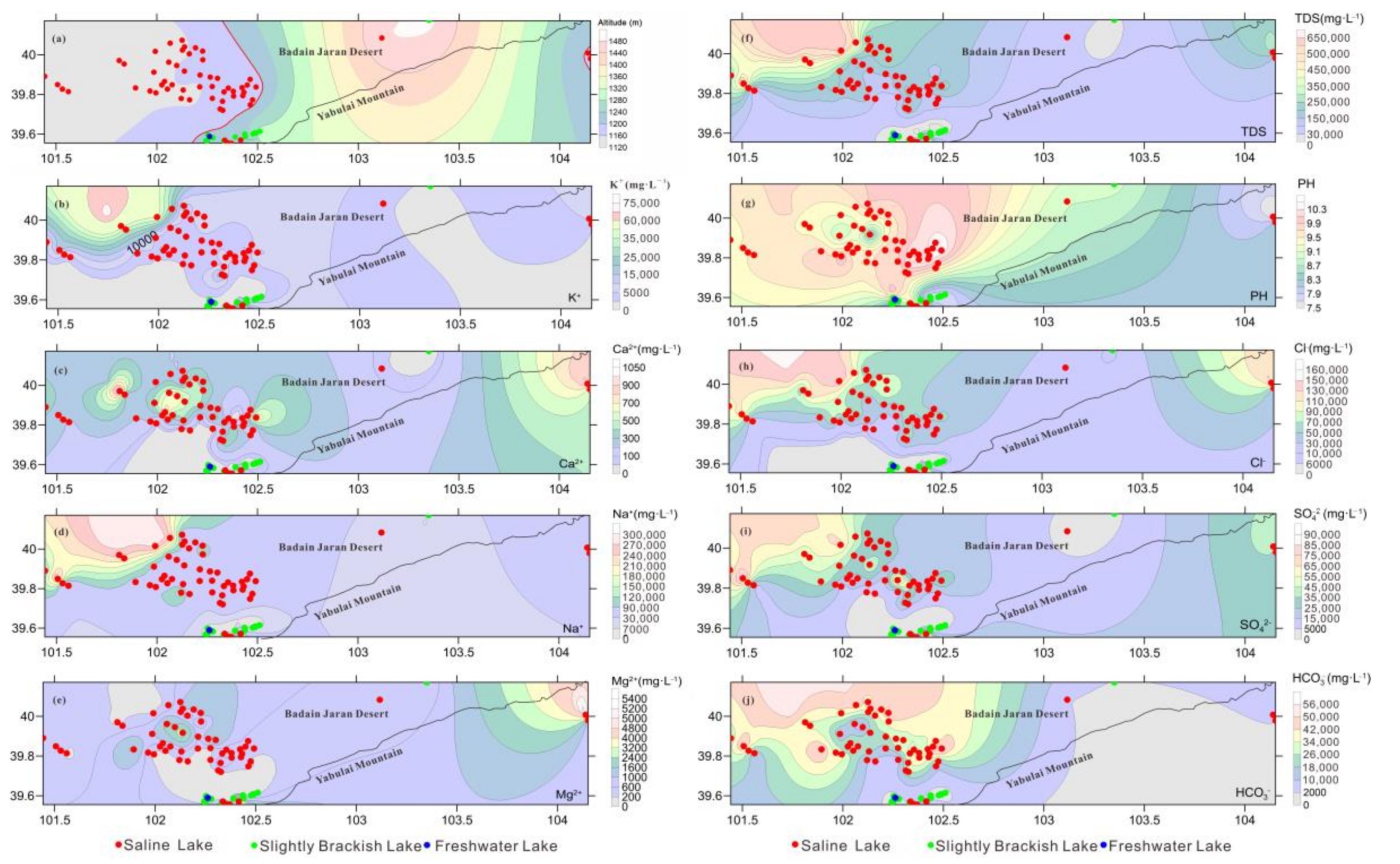
Topographic factors clearly control the distribution of slightly brackish and saline lakes, resulting in these lakes showing zonal distributions (Figure 7). Saline lakes tend to be found in relatively low-lying areas, whereas slightly brackish lakes are found in relatively high-lying areas. The larger lakes in the northern part of the desert and the lakes in the southeastern part of the desert are separated by a topographic fold and uplift, forming different groundwater recharge systems [42]. Therefore, there are significant differences in the hydrochemical types of the lakes in the region, despite their proximity. For example, the distance between Badain East Lake and Badain West Lake in the southeastern edge of the desert is less than 200 m, with the TDS of the latter lake exceeding that of the former by a factor of 100. This difference can be attributed to the higher water level of East Lake, resulting in the release of salt, whereas salt accumulates in the West Lake [43].
In our investigation, we found that the lakes on the southeast side of the desert were small and shallow, while the lakes on the north side were large and deep. The freshwater and slightly brackish lakes were mainly distributed in the piedmont area at a high altitude (1200–1300 m), whereas saline lakes were mainly distributed in the desert hinterland at a low altitude (1100–1200 m). As Figure 5 shows, Saline lakes are widely distributed in the region, while slightly brackish lakes are concentrated, mainly in the southeast of Yabuli Mountain. Among the 80 lake water samples, 21 located at the southern edge of the Badain Jaran Desert are freshwater and slightly brackish, with TDS ranging from 0.88 g L−1 to 20.21 g L−1. 35 hyposaline lakes located in the southern-central research area show TDS values from 39.44 g L−1 to 199.26 g L−1. Four mesosaline located in the west research area show TDS value from 279.48 g L−1 to 452.73 g L−1. The other 10 investigated lakes are all hypersaline, located in the northwest with TDS values varying between 467.01 g L−1 and 619.74 g L−1.Besides for Ca2+, Mg2+ and PH, the change trend of other anions and cations is consistent with TDS. There is a roughly increasing trend of ions from the southeast to northwest, and the West Nuoertu Lake located on the northwest edge had the highest salinity while the Dundejilin Lake located on the southern edge had the lowest salinity.
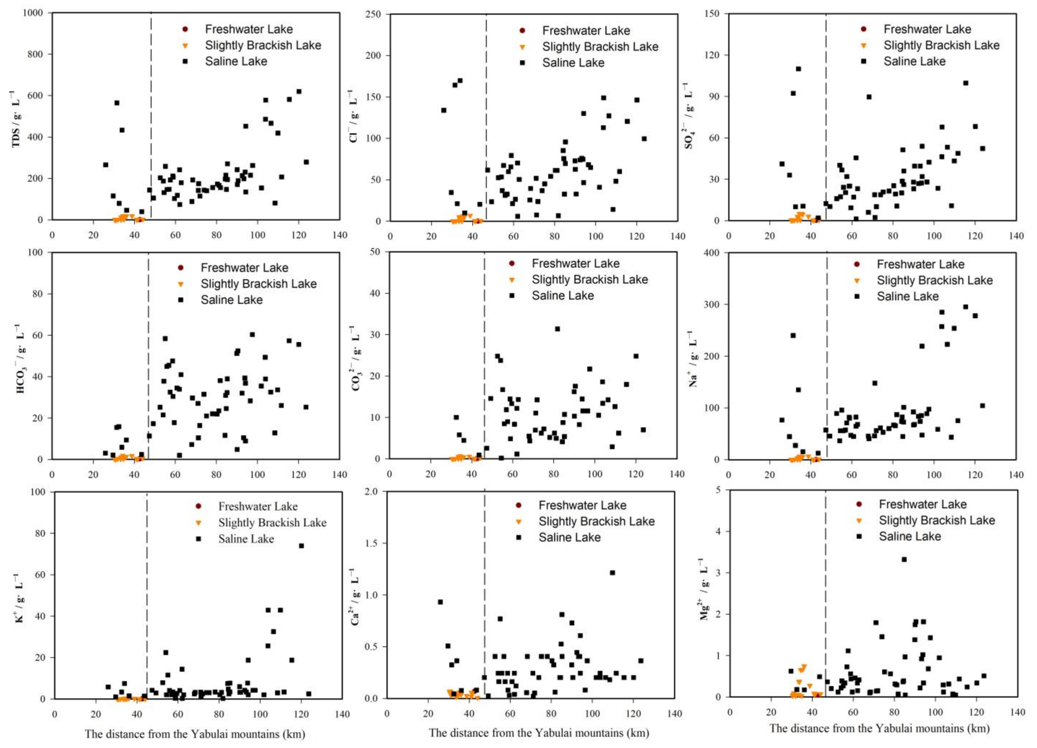
Freshwater and slightly brackish lakes were concentrated within 30–45 km from the Yabulai Mountain. Saline lakes were widely distributed over a range of between 20–135 km. This lake distribution shown a close relationship between lake water and precipitation in Yabuli Mountain [44,45]. Due to the concentrated distribution of slightly brackish water lake, the variation trend of hydrochemical from Yabulai Mountain is not significant, we focus on the analysis of the relationship between the hydrochemical changes of saline lake and the distance from Yabulai Mountain (Figure 8). Significant changes in Cl−, SO42−, and Na+ occurred. Cl− increased from 6.07 g·L−1 to 169.83 g·L−1, SO42− increased from 1.33 g·L−1 to 110.05 g·L−1, whereas Na+ increased from 12.79 g·L−1 to 295.48 g·L−1. The values of TDS, Cl−, SO42−, HCO3−, CO32− and Na+ in most saline lakes increase with the distance from the Yabulai Mountains. Nine lakes, about 100 km from the Yabulai Mountain, have exceptionally high sodium and potassium levels. Along the terrain from the southeast to the northwest, the farther away from the Yabulai Mountains, the higher the ion content. The freshwater lakes and slightly brackish lakes in the Badain Jaran Desert are recharged by mountain precipitation and lateral runoff. The rapid rate of lake water renewal leads to a relatively low lake water TDS. The saline lakes are positioned far away from the mountain area and receive groundwater recharge. The long recharge path and complex geological conditions result in a slow lake water regeneration rate and intense evaporation, leading to relatively high TDS. This conclusion is consistent with that of Yang [46]. It is believed that the shallow groundwater is recharged by recent local precipitation infiltration near Yabulai Mountain in the southeastern margin of the desert, whereas deep groundwater is recharged by precipitation during humid periods. This assertion is consistent with the analyses by Hofmann [47] which showed the presence of two discontinuous hydraulic flow systems in this area. One is located north of the geological anticline, ~40 km from the southern edge of the desert. This flow system is recharged by precipitation. The other is located south of the geological anticline and is recharged by water from outside the dune area.
4.3. Analysis of Mechanisms Contributing to the Hydrochemistry of Different Types of Lakes
In general, the major sources of dissolved ions in lakes include input from precipitation, weathering rocks, regional geologic, and anthropogenic input [48]. Evidenced by Gibbs diagram in Figure 4, indicated that the evaporation-crystallization reactions are the dominant in the study region. Moreover, some saline mineral deposits, including gypsum, hailte, anhydrite, epsomite, mirabilite, and thenardite, are extensive in these regions caused by intense evaporation-crystallization. Intense evaporation is a vital driving force in the formation of lakes and also affects their hydrochemical components and water balance. The higher HCO3−, SO42−, Ca2+, and Mg2+ concentration in lakes from the freshwaterlake demonstrate that those regions are enriched in minerals like anhydrite, aragonite, calcite, dolomite and gupsum. In comparison to this lake, the slightly brackish and saline lakes have lower Ca2+. Calcium consumption led to the progressive enrichment of Na+, SO42−, and Cl− in the lake brines where halite, thenardite, epsomiteand, and Mirabilite precipitated. The samples from lake were far below saturation with chloride minerals such as halite, showed by the negative SI values ranging between −11.36 and 3.22, which confirms that the soluble component Na+ and Cl− concentration was not limited by mineral equilibrium in the sediments of the study area. Table 2 showed the saturation index of main minerals in lakes water, which were used to understand the hydrogeochemical evolution processes during flow paths of the groundwater from the recharge zone to the discharge zone. Based on mineral SI result, Ca2+/Na+ ratio and the geological condition of the study area, the hydrogeochemical processes mainly included the dissolution of anhydrite, gypsum, halite, epsomite, mirabilite, and thenardite, and the precipitation of calcite, dolomite, magnesite, and aragonite from the recharge zone to the discharge zone.
5. Conclusions
The Badan Jaran desert is a vast arid region endowed with perennial lakes with varying salinities (0.88–619.74 g L−1) and high pH values (7.54–10.52) due to the abundance of Na+, K+, Cl− and SO42−. The results according to TDS of the water samples from 80 lakes indicated that freshwater, slightly brackish, brackish, and saline water lakes accounted for 1.25%, 25%, 0.0%, and 73.75%, respectively. The Piper termary diagram indicate that the lake hydrochemistry changed from the SO42−-Cl−-HCO3− type to the SO42−-Cl− type and lakes transitioned from freshwater to saline. Enrichment of Na+ in the lake water of the Badain Jaran Desert exceeds that of Cl−, suggesting strong evaporative concentration and cation exchange. The spatial distribution of ion contents in the lakes indicated that freshwater and slightly brackish lakes were mainly distributed in the piedmont area at a high altitude (1200–1300 m) and were concentrated within 30–45 km from the Yabulai Mountain, whereas saline lakes were mainly distributed in the desert hinterland at a low altitude (1100–1200 m) and were widely distributed over a range of between 20–135 km, there is a roughly increasing trend of ions from the Yabulai Mountains. Evidenced by Gibbs diagram indicated that the evaporation-crystallization reactions are the dominant in the study region. Moreover, some saline mineral deposits, including gypsum, hailte, anhydrite, epsomite, mirabilite, and thenardite, are extensive in these regions caused by intense evaporation-crystallization.
Author Contributions
Conceptualization, B.J. and J.S.; methodology, B.J., H.X.; formal analysis, B.J.; investigation, B.J. and J.Q.; writing-original draft preparation, B.J.; writing-review and editing, B.J., J.S.; funding acquisition, J.S. All authors have read and agreed to the published version of the manuscript.
Funding
This research was funded by the Major Science and Technology Project in Inner Mongolia Autonomous Region of China (No. zdzx2018057) and the Innovation Cross Team Project of Chinese Academy of Sciences, CAS (No. JCTD-2019-19), Transformation Projects of Scientific and Techological Achievements in Inner Mongolia Autonomous region of China (No. 2021CG0046).
Institutional Review Board Statement
Not applicable.
Informed Consent Statement
Not applicable.
Data Availability Statement
The data that support the findings of this study are available from the corresponding author on reasonal request.
Acknowledgments
We thank all the participants in the Alashan Desert Eco-hydrological Experimental research Station, Northwest Institute of Eco-Environment and Resources, Chinese Academu of Sciences. We greatly appreciate suggestions from anonymous referees for the improvement of our paper. Thanks also to the editorial staff.
Conflicts of Interest
The authors declare no conflict of interest.
References
- Fan, Z.; Zhang, L. Hydrochemistry of lakes in Xinjiang. Arid Zone Res. 1992, 9, 1–8. [Google Scholar]
- Ma, N.; Wang, N.; Li, Z.; Chen, X.; Zhu, J.; Dong, C. Analysis on Climate Change in the Northern and Southern Marginal Zones of the Badain Jaran Desert during the Period 1960–2009. Arid Zone Res. 2011, 28, 243–250. [Google Scholar]
- Ma, N.; Wang, N.; Zhu, J.; Chen, X.; Chen, H.; Dong, C. Climate Change around the Badain Jaran Desert in Recent 50 Years. J. Desert Res. 2011, 31, 1541–1547. [Google Scholar]
- Gulbostan, T.; Pang, Z.; Shang, Y. The Source of Lake Water Supply from the Comparison of Isotopic and Hydrochemical in Desert Area: Taking Mukainao Lake in Ordos Basin as an Example. Xinjiang Geol. 2020, 38, 546–551. [Google Scholar]
- Wang, S.; Dou, H.; Chen, K.; Wang, X.; Jiang, J. A General Survey of Lakes in China. Lakes in China, 1st ed.; Science Press: Beijing China, 1998; Volume 6, pp. 320–347. [Google Scholar]
- Lu, Y.; Wang, N.; Li, G.; Li, Z.; Dong, C.; Lu, J. Spatial distribution of lakes in Badain Jaran Desert. J. Lake Sci. 2010, 22, 774–782. [Google Scholar]
- Li, J.; Edmunds, W.M.; Lu, Z.; Ma, J. Geochemistry of sediment moisture in the Badain Jaran desert: Implications of recent environmental changes and water-rock interaction. Appl. Geochem. 2015, 63, 235–247. [Google Scholar]
- Chen, J.S.; Li, L.; Wang, J.Y.; Barry, D.; Sheng, X.F.; Zu Gu, W.; Zhao, X.; Chen, L. Groundwater maintains dune landscape. Nature 2004, 432, 459–460. [Google Scholar] [CrossRef]
- Chen, J.; Fan, Z.; Wang, J.; Gu, W.; Zhao, X. Isotope Methods for Studying the Replenishment of the Lakes and Downstream Groundwater in the Badain Jaran Desert. Acta Geosci. Sin. 2003, 24, 497–504. [Google Scholar]
- Ma, J.; Chen, F.; Zhao, H. Vadose geochemical records of groundwater recharge and climate change in the Badain Jaran Desert since 1000 years. Chin. Sci. Bull. 2004, 49, 22–26. [Google Scholar]
- Ma, J.; Huang, T.; Ding, Z.; Edmunds, W. Environmental Isotopes as the Indicators of the Groundwater Recharge in the South Badain Jaran Desert. Adv. Earth Sci. 2007, 22, 922–930. [Google Scholar]
- Chen, W.; Huang, X.; Zhou, W. Methods of Lake Ecosystem Observation; China Environmental Science Press: Beijing, China, 2005; ISBN 978780163745. [Google Scholar]
- Dong, Z.; Qian, G.; Lv, P.; Hu, G. Investigation of the sand sea with the tallest dunes on Earth: China’s Badain Jaran Sand Sea. Earth-Sci. Rev. 2013, 120, 20–39. [Google Scholar] [CrossRef]
- Ma, R.; Yang, G.; Duan, H.; Jiang, J.; Wang, S.; Feng, X.; Li, A.; Kong, F.; Xue, B.; Wu, J.; et al. The number, area and spatial distribu-tion of lakes in China. Sci. Sin. Terrae 2011, 41, 394–410. [Google Scholar]
- Zhang, Z.; Wang, N.; Ma, N.; Dong, C.; Chen, L.; Shen, S. Lakes Area change in Badain Jaran Desert Hinterland and Its Influence Factors during the Recent 40 Years. J. Desert Res. 2012, 32, 1743–1750. [Google Scholar]
- Banda, J.F.; Lu, Y.; Hao, C.; Pei, L.; Du, Z.; Zhang, Y.; Wei, P.; Dong, H. The Effects of Salinity and pH on Microbial Commu-nity Diversity and Distribution Pattern in the Brines of Soda Lakes in Badain Jaran Desert, China. Geomicrobiol. J. 2020, 37. [Google Scholar] [CrossRef]
- Dong, G.; Gao, Q.; Zou, X.; Li, B.; Yan, C. Climate change in southern Margin of Badain Jaran Desert since late Pleistocene. Chinese Sci. Bull. 1995, 40, 1214–1218. [Google Scholar]
- Cao, L.; Nie, Z.; Jiang, G.; Liu, M.; He, P.; Tong, L.; Wang, J. Water Volume Change of Lakes in the Badain Jaran Desert and Its Causes Based on GF Satellite Remote Sensing Date. Yellow River 2020, 42, 40–45. [Google Scholar]
- Yang, X.; Ma, N.; Dong, J.; Zhu, B.; Xu, B.; Ma, Z.; Liu, J. Recharge to the Inter-Dune Lakes and Holocene Climatic Changes in the Badain Jaran Desert, Western China. Quat. Res. 2010, 73, 10–19. [Google Scholar] [CrossRef]
- Zhang, Z.; Liang, A.; Zhang, C.; Dong, Z. Gobi deposits play a significant role as sand sources for dunes in the Badain Jaran Desert, Northwest China. CATENA 2021, 206, 105530. [Google Scholar] [CrossRef]
- Yang, X.; Williams, M.A. The ion chemistry of lakes and late Holocene desiccation in the Badain Jaran Desert, Inner Mongolia, China. CATENA 2003, 51, 45–60. [Google Scholar] [CrossRef]
- Yang, X. Water chemistry of the lakes in the Badain Jaran Desert and their holocene evolutions. Quat. Sci. 2002, 2, 97–104. [Google Scholar]
- Ning, K.; Wang, N.; Yang, Z.; Zhang, L.; Wang, Y.; Li, Z.; Bi, Z. Holocene vegetation history and environmental changes inferred from pollen records of a groundwater recharge lake, Badain Jaran Desert, northwestern China. PalaGeogr. Palae-Oclimatol. Palaeoecol. 2021, 577, 110538. [Google Scholar] [CrossRef]
- Gates, J.B.; Edmunds, W.M.; Darling, W.G.; Ma, J.; Pang, Z.; Young, A.A. Conceptual model of recharge to southeastern Badain Jaran Desert groundwater and lakes from environmental tracers. Appl. Geochem. 2008, 23, 3519–3534. [Google Scholar] [CrossRef] [Green Version]
- Wu, Y.; Wang, N.; Zhao, L.; Zhang, Z.; Chen, L.; Lu, Y.; Lü, X.; Chang, J. Hydrochemical characteristics and recharge sources of Lake Nuoertu in the Badain Jaran Desert. Chin. Sci. Bull. 2014, 59, 886–895. [Google Scholar] [CrossRef]
- Zhang, J.; Wang, X.; Hu, X.; Lu, H.; Ma, Z. Research on the recharge of the lakes in the Badain Jaran Desert: Simulation study in the Sumu Jaran Lakes area. J. Lake Sci. 2017, 29, 467–479. [Google Scholar]
- Thomas, J.; Joseph, S.; Thrivikramji, K. Hydrochemical variations of a tropical mountain river system in a rain shadow region of the southern Western Ghats, Kerala, India. Appl. Geochem. 2015, 63, 456–471. [Google Scholar] [CrossRef]
- Han, G.; Liu, C. Hydrogeochemistry of Wujiang River water in Guizhou Province, China. Chin. J. Geochem. 2001, 20, 240–248. [Google Scholar] [CrossRef]
- Wu, E. Hydrochemistry of inland rivers in the north Tibetan Plateau: Constrains and weathering rate estimation. Sci. Total Environ. 2016, 541, 461–482. [Google Scholar] [CrossRef]
- Cui, B.-L.; Li, X.-Y.; Wei, X.-H. Isotope and hydrochemistry reveal evolutionary processes of lake water in Qinghai Lake. J. Great Lakes Res. 2016, 42, 580–587. [Google Scholar] [CrossRef] [Green Version]
- Wang, F.; Sun, D.; Chen, F.; Bloemendal, J.; Guo, F.; Li, Z.; Zhang, Y.; Li, B.; Wang, X. Formation and evolution of the Badain Jaran Desert, North China, as revealed by a drill core from the desert center and by geological survey. PalaGeogr. Palae-Oclimatol. Palaeoecol. 2015, 426, 139–158. [Google Scholar] [CrossRef]
- Wang, T. Formation and Evolution in the Badan Jaran Desert. J. Desert Res. 1990, 10, 29–40. [Google Scholar]
- Wang, X.; Hu, X.; Jin, X.; Hou, L.; Qian, R.; Wang, L. Interactions between groundwater and lakes in the Badan Jaran Desert. Earth Sci. Front. 2014, 21, 91–99. [Google Scholar]
- Zhang, J.; Wang, X.; Hu, X.; Lu, H.; Gong, Y.; Wan, L. The macro- characteristics of groundwater flow in the Badain Jaran desert. J. Desert Res. 2015, 35, 774–782. [Google Scholar]
- Rui, X. The Surface Water. Principles of Hydrology, 1st ed.; China Water & Power Press: Beijing, China, 2004; ISBN 9787508421643. [Google Scholar]
- Shao, T.; Zhao, J.; Dong, Z. Water Chemistry of the Lakes and Groundwater in the Badain Jaran Desert. Acta Geogr. Sin. 2011, 66, 662–670. [Google Scholar]
- Wang, X.; Zhou, Y. Investigating the mysteries of grounds in the Badain Jaran Desert, China. Hydrogeol. J. 2018, 26, 1639–1655. [Google Scholar] [CrossRef]
- Dong, C.; Wang, N.; Chen, J.; Li, Z.; Chen, H.; Chen, L.; Ma, N. New obervational and experimental evidence for the re-charge mechanism of the lake group in the Alxa Desert, North-central China. J. Arid Environ. 2016, 124, 48–61. [Google Scholar] [CrossRef]
- Gao, Z.; Lin, Z.; Niu, F.; Luo, J.; Liu, M.; Yin, G. Hydrochemistry and controlling mechanism of lakes in permafrost regions along the Qinghai-Tibet Engineering Corridor, China. Geomorphology 2017, 297, 159–169. [Google Scholar] [CrossRef]
- He, J.; Zhang, J.; Ding, Z.; Ma, J. Evolution of groundwater geochemistry in the Minqin Basin: Taking chloride as an indica-tor of groundwater recharge. Resour. Sci. 2011, 33, 416–421. [Google Scholar]
- He, J.; Ma, J.; Zhang, P.; Tian, L.; Zhu, G.; Edmunds, W.M.; Zhang, Q. Groundwater recharge environments and hydrogeo-chemical evolution in the Jiuquan Basin, Northwest China. Appl. Geochem. 2012, 27, 866–878. [Google Scholar] [CrossRef]
- Ma, N.; Yang, X. Characteristics of hydrochemistry and environmental isotopes in the Badain Jaran Desert and its southeast-ern margin and their hydrological significance. Quat. Sci. 2008, 28, 702–711. [Google Scholar]
- Zhang, H.; Hu, X.; Wang, X. Research on Geomorphologic Evolution of East and West Badain Lake and the Impact on Water Body Features. Geoscience 2017, 31, 406–414. [Google Scholar]
- Jin, K.; Rao, W.; Zhang, W.; Zheng, F.; Wang, S. Strontium isotopic and hydrochemical characteristics of shallow groundwater and lake water in the Badain Jaran Desert, North China. Isot. Environ. Health Stud. 2021, 57, 516–534. [Google Scholar] [CrossRef]
- Ma, J.; Enmunds, W. Groundwater and lake evolution in the Badain Jaran Desert ecosystem, Inner Mongolia. Hydrogeol. J. 2006, 14, 1231–1243. [Google Scholar] [CrossRef]
- Yang, X. Chemistry and late Quaternary evolution of ground and surface waters in the area of Yabulai Mountains, western Inner Mongolia, China. CATENA 2006, 66, 135–144. [Google Scholar] [CrossRef]
- Hofmann, J. The lakes in the SE part of Badain Jaran Shamo, their limnology and geochemistry. Geowissenschaften 1996, 14, 275–278. [Google Scholar]
- Yuan, R.; Wang, M.; Wang, S.; Song, X. Water transfer imposes hydrochemical impacts on groundwater by altering the in-teraction of groundwater and surface water. J. Hydrol. 2020, 583. [Google Scholar] [CrossRef]
Figure 1.
Map showing location of the study site and lake water samples, black line showing the terrain direction, and red lines showing the boundry of Badain Jaran Desert.The other portion indicates the sampling sites of the 80 sampled lakes in the desert with their locations highlighted as saline lake, slightly brackish lake and freshwater lake. The remote-sensing images were taken from Loca Space Viewer.

Figure 2.
Ion concentrations (in meq) in individual types of lakes.

Figure 3.
The Piper diagram of lake water in the Badain Jaran Desert.

Figure 4.
Gibbs diagram of the water samples in the Badain Jaran Desert.

Figure 5.
The relationships between (a) Na+ and Cl− and (b) (Ca2+ + Mg2+) − (HCO3− + SO42−) and Na+ + K+ − Cl−.
Figure 5.
The relationships between (a) Na+ and Cl− and (b) (Ca2+ + Mg2+) − (HCO3− + SO42−) and Na+ + K+ − Cl−.

Figure 6.
The relationships between (a) Halite Saturation Index and Na+ + Cl−/g L−1 and (b) Gypsum Saturation Index and Ca2+ + SO42−/g L−1.
Figure 6.
The relationships between (a) Halite Saturation Index and Na+ + Cl−/g L−1 and (b) Gypsum Saturation Index and Ca2+ + SO42−/g L−1.

Figure 7.
The spatial distribution of ion contents in the lakes of the Badain Jaran Desert.

Figure 8.
The variability of lake ions distance from the Yabulai Mountains.


Table 1.
Descriptive statistics of lakes physico-chemical properties in the Badain Jaran Desert.
| Freshwater Lake | Slightly Brackish Lake | Saline Lakes | |||||||||||||
|---|---|---|---|---|---|---|---|---|---|---|---|---|---|---|---|
| Sample | 1 | 20 | 59 | ||||||||||||
| Value | Min | Max | Mean | SD | CV | Kurtosis | Skewness | Min | Max | Mean | SD | CV | Kurtosis | Skewness | |
| g L−1 | g L−1 | g L−1 | g L−1 | g L−1 | g L−1 | ||||||||||
| PH | 7.93 | 7.65 | 10.1 | 8.47 | 0.75 | 0.09 | −0.76 | 0.54 | 7.54 | 10.52 | 9.60 | 0.58 | 0.06 | 2.63 | −1.21 |
| TDS | 0.88 | 1.13 | 20.21 | 6.76 | 7.57 | 1.12 | −0.91 | 0.98 | 39.44 | 619.74 | 221.54 | 137.96 | 0.62 | 1.68 | 1.52 |
| Na+ | 0.09 | 0.30 | 6.53 | 2.08 | 2.45 | 1.17 | −0.59 | 1.10 | 12.79 | 295.48 | 93.01 | 70.24 | 0.76 | 2.19 | 1.79 |
| K+ | 0.02 | 0.01 | 0.31 | 0.10 | 0.11 | 1.18 | −0.09 | 1.29 | 0.25 | 73.97 | 8.75 | 14.04 | 1.61 | 9.26 | 2.95 |
| Mg2+ | 0.05 | 0.02 | 0.75 | 0.22 | 0.25 | 1.15 | 0.08 | 1.24 | 0.05 | 7.13 | 0.81 | 1.22 | 1.51 | 14.77 | 3.57 |
| Ca2+ | 0.07 | 0.01 | 0.07 | 0.04 | 0.02 | 0.47 | −1.18 | −0.04 | 0.02 | 1.21 | 0.30 | 0.23 | 0.78 | 3.75 | 1.68 |
| Cl− | 0.15 | 0.22 | 6.94 | 2.10 | 2.55 | 1.21 | −0.90 | 0.99 | 6.07 | 169.83 | 62.58 | 40.16 | 0.64 | 0.47 | 0.96 |
| SO42− | 0.33 | 0.31 | 5.21 | 1.67 | 1.84 | 1.10 | −0.25 | 1.17 | 1.33 | 110.05 | 32.52 | 23.67 | 0.73 | 2.29 | 1.46 |
| HCO3− | 0.25 | 0.15 | 1.86 | 0.66 | 0.56 | 0.85 | −0.21 | 1.10 | 1.97 | 60.33 | 27.69 | 15.69 | 0.57 | −0.72 | 0.19 |
| CO32− | 0.06 | 0.02 | 0.67 | 0.23 | 0.23 | 0.99 | −1.14 | 0.67 | 0.21 | 31.37 | 10.82 | 6.64 | 0.61 | 0.81 | 0.87 |
Min: minimum value; Max: maximum value; Mean: mean value; SD: standard deviation; CV: coefficient of variation.
Table 2.
Statistics of saturation index of main minerals in lakes water.
| Anhydrite | Aragonite | Calcite | Dolomite | Epsomite | Gypsum | Magnesite | Mirabilite | Thenardite | Halite | |
|---|---|---|---|---|---|---|---|---|---|---|
| Mean value | −0.76 | 2.65 | 2.80 | 5.86 | −2.92 | −0.72 | 3.03 | −1.35 | −1.41 | −2.53 |
| Minimum value | −2.68 | −0.35 | −0.20 | −0.38 | −9.18 | −2.48 | −0.37 | −6.61 | −7.50 | −11.36 |
| Maximum value | 2.36 | 6.52 | 6.67 | 13.53 | −1.03 | 1.55 | 6.86 | 0.93 | 5.30 | 3.22 |
Publisher’s Note: MDPI stays neutral with regard to jurisdictional claims in published maps and institutional affiliations. |
© 2021 by the authors. Licensee MDPI, Basel, Switzerland. This article is an open access article distributed under the terms and conditions of the Creative Commons Attribution (CC BY) license (https://creativecommons.org/licenses/by/4.0/).
Share and Cite
MDPI and ACS Style
Jia, B.; Si, J.; Xi, H.; Qin, J. A Characterization of the Hydrochemistry and Main Controlling Factors of Lakes in the Badain Jaran Desert, China. Water 2021, 13, 2931. https://doi.org/10.3390/w13202931
AMA Style
Jia B, Si J, Xi H, Qin J. A Characterization of the Hydrochemistry and Main Controlling Factors of Lakes in the Badain Jaran Desert, China. Water. 2021; 13(20):2931. https://doi.org/10.3390/w13202931
Chicago/Turabian StyleJia, Bing, Jianhua Si, Haiyang Xi, and Jie Qin. 2021. "A Characterization of the Hydrochemistry and Main Controlling Factors of Lakes in the Badain Jaran Desert, China" Water 13, no. 20: 2931. https://doi.org/10.3390/w13202931
Note that from the first issue of 2016, this journal uses article numbers instead of page numbers. See further details here.