Article

The LTER-Greece Environmental Observatory Network: Design and Initial Achievements

by
Nikolaos Theodor Skoulikidis
1,*,
Nikolaos Pavlos Nikolaidis
2,
Andreas Panagopoulos
3,
Marina Fischer-Kowalski
4,
Stamatis Zogaris
1,
Panos Petridis
4,
Vassilis Pisinaras
3,
Dionissis Efstathiou
2,
Theodora Petanidou
5,
Giorgos Maneas
6,
Nikolaos Mihalopoulos
7 and
Maria Mimikou
8
1
Hellenic Centre for Marine Research, Institute of Marine Biological Resources and Inland Waters, 19013 Attika, Greece
2
School of Chemical and Environmental Engineering, Technical University of Crete, 73100 Chania, Greece
3
Hellenic Agricultural Organization (DEMETER), Soil and Water Resources Institute, 57400 Sindos, Greece
4
Institute of Social Ecology, University of Natural Resources and Life Sciences, A-1070 Vienna, Austria
5
Department of Geography, University of the Aegean, 81100 Mytilini, Greece
6
Navarino Environmental Observatory, Department of Physical Geography, Stockholm University, 10691 Stockholm, Sweden
7
Department of Chemistry, University of Crete, 70013 Heraklion, Greece
8
School of Civil Engineering, National Technical University of Athens, 15780 Athens, Greece
*
Author to whom correspondence should be addressed.
Water 2021, 13(21), 2971; https://doi.org/10.3390/w13212971
Submission received: 14 September 2021 / Revised: 14 October 2021 / Accepted: 18 October 2021 / Published: 21 October 2021
(This article belongs to the Section Water Resources Management, Policy and Governance)

Abstract

:
Five years after its establishment (2016), the LTER-Greece network outlines its vision, aims, objectives and its achievements through a series of case studies. The network consists of eight observatories, focusing on innovative research topics, aiming to be both cooperative and complementary, while currently being in the process of expanding. LTER-Greece acknowledges the complexity of ecosystems and the fact that effective management of natural resources may only be achieved by addressing every sector of a nexus system in order to understand inter-dependencies, thus accounting for solutions that promote resilience. Hence, LTER-Greece focuses on the holistic study of the water-environment-ecosystem-food-energy-society nexus, in order to face environmental and socio-ecological challenges at local and global scales, particularly climate change, biodiversity loss, pollution, natural disasters and unsustainable water and land management. Framed around five research pillars, monitoring and research targets nine research hypotheses related to climate change, environmental management, socio-ecology and economics, biodiversity and environmental process dynamics. As environmental monitoring and related research and conservation in Greece face critical shortcomings, LTER-Greece envisages confronting these gaps and contributing with interdisciplinary solutions to the current and upcoming complex environmental challenges.

Graphical Abstract

1. Introduction

During the past century, humanity has experienced unprecedented increases in population, resulting in increased food, water and energy demands, and this trend is expected to continue during this century. An increase of the world population to 9.8 billion by 2050 is anticipated to trigger increases in water demand by 20–30% [1], food demand by 102% [2,3] and energy demand by 25–58% [4]. Urbanization will increase from 56% of the population residing in urban areas in 2019 to 69% in 2050 (6.7 billion) [5]. Desertification and managing extreme events (floods, droughts, mega wildfires, etc.) will cause additional challenges. Through their cumulative impacts on energy resources, land use, habitats, biodiversity and human health [6], these challenges are expected to extend planetary pressures beyond Earth’s “safe operating space” [7] and severely affect human wellbeing. Our society must address these global issues while mitigating and adapting to the impacts of climate change [8].
Addressing the combined impact of these challenges requires a holistic systems approach [9], both environmental and socio-ecological, based on reliable long-term data and environmental observations. The need for observatory science and the coordination of fragmented disciplines that would unify concepts and methodologies has been widely accepted by the scientific community in the past two decades as a fundamental prerequisite to address these complex challenges. Such an example is the International Long-term Ecological Research (ILTER) network (https://lternet.edu/, accessed on 15 April 2021) which spans over all continents and comprises more than 800 Long-term Ecological Research (LTER) sites, approximately 80 long-term socio-ecological research (LTSER) platforms, a web of 44 national networks and several continental regional groups with robust governance structures [9]. Its role is to provide fundamental understanding of natural processes necessary to conserve, protect and manage ecosystem biodiversity and services.
Another international example is the Critical Zone Exploration Network (CZEN) (https://www.czen.org, accessed on 15 April 2021), aiming to investigate processes within the Critical Zone, which is defined as the layer of the Earth that sustains life outwards from bedrock to treetop. As it is the case with ILTER, CZEN has incorporated significant regional networks such as the French OSCAR and the German TERENO networks. Among other noteworthy international continental-scale observatory establishments are the US National Ecological Observatory Network (NEON; https://www.neonscience.org, accessed on 15 April 2021) aiming to understand how and why ecosystems are changing by collecting long-term, standardized data on ecological responses, and the Australian Terrestrial Ecosystem Research Network (TERN) (https://www.tern.org.au/, accessed on 15 April 2021), also focusing on ecological monitoring and research.
While Long-term Ecological Research (LTER) deals with patterns and processes in ecosystems over long temporal scales, the more recently established interdisciplinary field of Long-Term Socio-Ecological Research (LTSER) attempts to include a socio-economic dimension, investigating not only changes in ecosystems, but also societal pressures and their underlying driving forces, as well as impacts of changing ecosystems on society and the economy. Concerned primarily with questions of socio-ecological sustainability LTSER aims to observe, analyze, understand and model changes in coupled socio-ecological (or human-environment) systems over long periods of time [10].
Socio-ecological research builds upon a dynamic socio-metabolic systems approach, relating local natural resources and their self-regenerating capacities to their social utilization and the resulting human benefits, both from an input (resource extraction) and an output (flows of wastes and emissions) perspective. Moreover, the research is designed by transdisciplinary principles and aims at supporting the local administration in achieving practical sustainable development goals [11,12].
The European Union has a long tradition of strengthening the scientific integration of Europe through the development of major research infrastructures. The European Strategy Forum on Research Infrastructures (ESFRI) was established in 2002 and is managed by the European Council. In 2018, the eLTER Research Infrastructure was formally accepted in the ESFRI Roadmap (http://roadmap2018.esfri.eu, accessed on 10 April 2021) and is currently in the design and synthesis phase.
Greece is a mountainous country with a rugged terrain, complex geomorphological structure, varied climatic zones and diverse terrestrial and aquatic ecosystems. As a result of its position at the edge of three continents, its high geological-climatic-spatial heterogeneity and its biogeographic role as glacial refugium, Greece is one of the most biodiverse countries in Europe [13,14]. The country encompasses landscapes of high aesthetic and cultural value, whilst a high portion (27.4% vs. the EU average 18.2%) of the national land area and a significant part of its marine area are protected under the NATURA 2000 area network [15]. Greece is also rich in water resources, but these are spatially and temporally unequally distributed [16]; it also hosts a multitude of inland wetland systems, including large delta and natural lake areas designated as RAMSAR Convention sites.
At the same time, the country is facing unprecedented socio-economic, e.g., [14,15,17,18] and environmental challenges, e.g., [11,19,20,21,22,23,24]. The IPCC (2014) [8] is projecting significant impacts in the region due to climate change. Water management, especially providing water for irrigation, will be a significant challenge in the future due to reduced precipitation and runoff, as well as increased frequency of droughts, including long-term epic droughts [25,26,27]. Degraded soils due to agriculture and livestock grazing are under imminent threat of desertification (including soil carbon loss). Mitigation of extreme events, together with reversing the trends of biodiversity loss, habitat fragmentation, aquatic quality deterioration and overfishing, complement the puzzle of environmental management that needs to be solved in the next few decades, in order to prevent catastrophic environmental degradation in Greece. Within this frame, the LTER-Greece was established in order to contribute to science-based solutions for such challenges.
The objective of this paper is to describe the design of the LTER-Greece network, its research priorities as well as recent interdisciplinary research collaboration results, as a means of demonstrating its service to society and the environment.

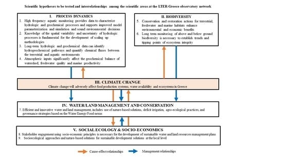
2. LTER-Greece Network

2.1. History, Vision and Objectives

Established in 2016, the Greek Long-Term Ecological Research Network (LTER-Greece) is a collaborative network of scientists and stakeholders, engaging in long-term, site-based environmental, ecological and socio-ecological research. The network of observatories focuses on the holistic study of the water-environment-ecosystem-food-energy-society nexus, in order to face the challenges of climate change, biodiversity loss, pollution, natural disasters and unsustainable management of land and water resources on a national, European and global scale. The network is a member of LTER-Europe and ILTER.
The vision of the network is to contribute to the improvement of the quality of life through long-term and large-scale research aimed at maintaining and upgrading ecosystem services, while sustainably using natural resources. On the other hand, its mission is to offer the scientific community, policy makers and society valid scientific information and predictive understanding of environmental, ecological and socio-economic processes, in order to produce and inform solutions for current and future environmental problems.
The goals of LTER-Greece are to:
Promote the cooperation and coordination of Greek researchers engaged in long-term environmental, ecological, socio-economic and critical zone research.
Develop standardized long-term environmental, ecological, social and economic data.
Undertake process-based research to better understand the mechanisms behind environmental deterioration in order to design appropriate remedial measures.
Support networking with the international scientific community for data exchange in order to delineate the spatial extent of environmental degradation drivers, thus contributing to in-depth comprehension of the controlling mechanisms at a global scale.
Educate the next generation of scientists.
Intensify dissemination of research results to the scientific community and policy makers.
Popularize dissemination of research results.
Contribute to the environmental awareness of local citizens and stakeholders and encourage them to play an active role in preserving their natural heritage.
The ambition of LTER-Greece is to provide society with the necessary knowledge to address current environmental challenges; help mitigate and adapt to the impacts of climate change; secure natural resources; protect biodiversity and landscape; and tackle natural disasters. The observatories are poles of attraction for new research ideas, cradles for hospitality and promotion of young scientists, centers for the development of innovation and places for consultation and application of social science.

2.2. Network Design

The design of the LTER-Greece network has been modular in nature. During the first phase of development, the selection of the sites followed a six-tier approach that adheres to the fundamental characteristics of the International LTER Network:
  • Site-based, in situ regular monitoring of and research into a broad spectrum of environmental variables at a local level (LTER sites) and of socio-ecological variables at a sub-regional level (LTSER platforms) that continuously feed scientific analyses, up-scaling, synthesis and theory development,
  • Long-term consistent research and monitoring with the time horizon of decades,
  • System approach to better understand complexity of ecological and socio-ecological systems, dynamics of abiotic and biotic variables, role and dynamics of system components and interrelations among them,
  • Process-oriented research, tracing dynamics of interactions between different components of socio-ecological systems, aiming at understanding complex cause-effect relationship and their dynamics in time,
  • Cover major environmental and socio-ecologic ecosystems, i.e., mixed land use, agricultural, urban and peri-urban, coastal and transitional, atmospheric, nature reserves, biodiversity and island ecosystems, and
  • Take advantage of complementary monitoring stations and related environmental observation infrastructure in order to increase the added value of the observatories through the co-location (i.e., ecological quality monitoring, biodiversity monitoring, atmospheric monitoring and modeling aspects).

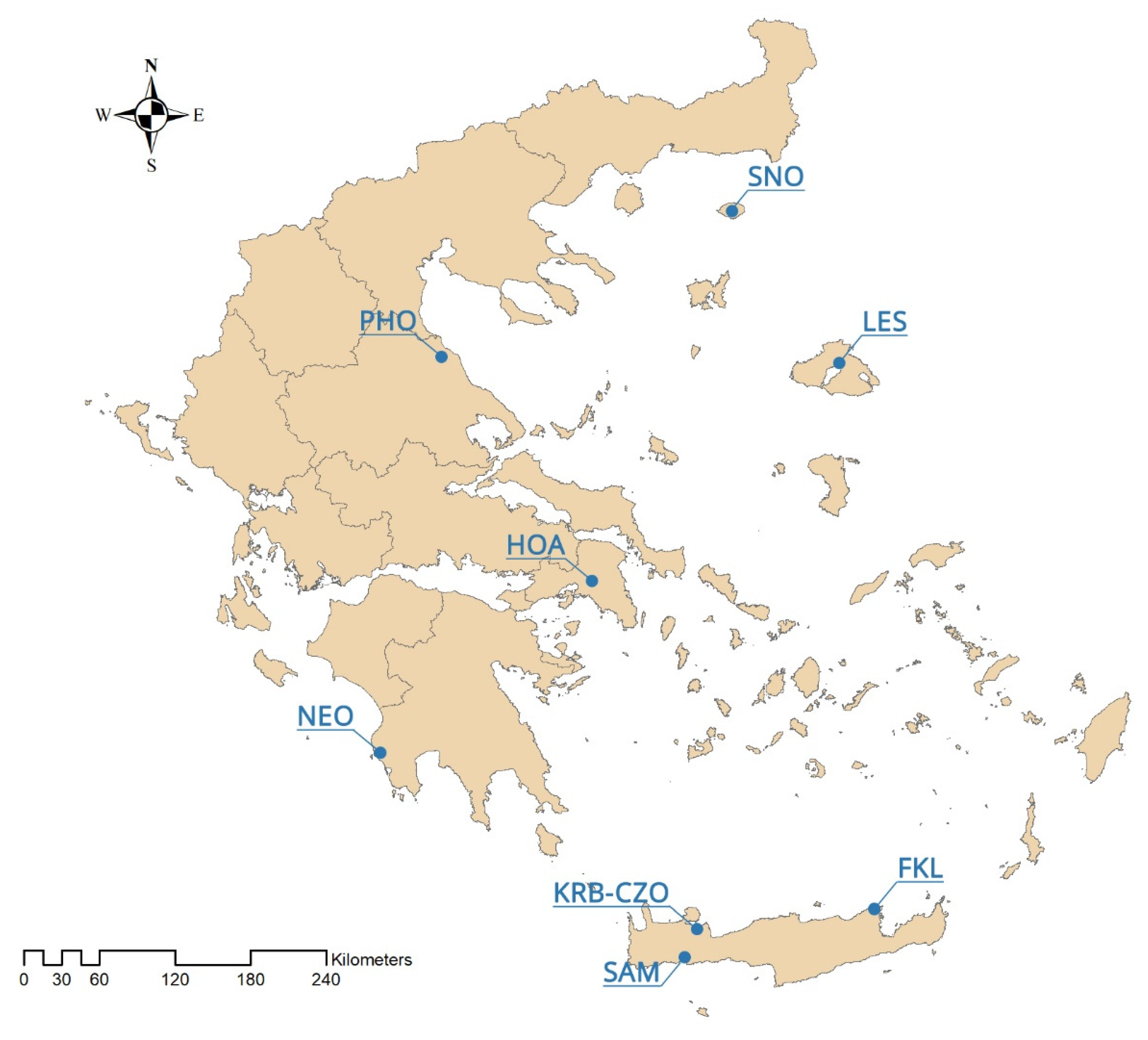
2.3. Network Description

The first phase of LTER-Greece network (2016–2021) consists of eight observatories (Figure 1) encompassing the rich biogeographical variability of the country (www.lter-greece.gr, accessed on 3 May 2021):
  • Koiliaris Critical Zone Observatory (mixed land-use watershed) [KRB-CZO],
  • Finokalia Atmospheric Observatory [FKL],
  • Samaria Gorge Observatory (National Park, Nature Reserve) [SAM],
  • Navarino Environmental Observatory (coastal ecosystem-lagoon) [NEO],
  • Hydrologic Observatory of Athens (urban and peri-urban ecosystem) [HOA],
  • Pinios Hydrologic Observatory (agricultural watershed) [PHO],
  • Lesvos Biodiversity Observatory (mixed land-use island) [LES],
  • Samothraki Nature Observatory (near pristine island) [SNO].
Koiliaris Critical Zone Observatory (KRB-CZO), operated by the Technical University of Crete (TUC), is an exemplary site for studying the Mediterranean soils under imminent threat of desertification due to climate change (www.koiliaris-czo.tuc.gr, accessed on 3 May 2021). The basin area of the karstic Koiliaris River is 130 km2 and the total length of the river is 36 km. High-frequency hydrologic and geochemical monitoring has been conducted since 2004 to obtain data for the characterization of hydrologic and biogeochemical processes. Applications of research results in Koiliaris CZO include: (i) the development of tools for water resources management and climate change adaptation, and (ii) for sustainable agricultural development and land management, (iii) experimental stations for deficit irrigation of avocado and olive trees and (iv) design of sustainable flood protection and restoration of riparian forests.
The Hydrologic Observatory of Athens (HOA) has been operated since 2005 by the Centre for Hydrology and Informatics (CHI) of the National Technical University of Athens (NTUA). It is located in the region of Attica, covering the greater Athens area. High-frequency hydrologic and meteorological monitoring is taking place for the assessment of weather conditions over the area and the analysis of hydrometeorological, hydrological, hydrochemical and hydrobiological parameters. In addition, research focuses on two river basins in Eastern Attica; an “experimental” catchment, covering an area of 15.18 km2 used for basic research [28,29] and an “operational” flood-prone basin (Rafina basin), covering an area of 127 km2, used for applied research. HOA has been utilized as a pilot in numerous elaborated research projects, amongst which is the recent EU-funded FLIRE, conducted in collaboration between HOA and the National Observatory of Athens (http://www.flire.gr, accessed on 3 May 2021).
Finokalia Atmospheric Observatory (FKL) is located on the north coast of Crete (http://finokalia.chemistry.uoc.gr/, accessed on 3 May 2021). It was established in 1993 and since then it has provided continuously high-quality data for a wide variety of atmospheric research topics. Air masses influenced from the marine boundary layer, continental Europe, the Sahara Desert and summer biomass burning areas are frequently observed. Finokalia’s strategic location on the crossroads of pollutants in the eastern Mediterranean, an area most vulnerable to climate change, makes an ideal natural laboratory for monitoring climatic perturbations and atmospheric processes in a varying time scale from seconds to decades.
Samaria National Park Observatory (SAM) is located on the Western part of the island of Crete and was declared a National Park in 1962 (www.samaria.gr, accessed on 3 May 2021). It is a multi-purpose designated area, namely National Park, Landscape of Outstanding Beauty, Natura 2000 site and Biosphere Reserve in the framework of “Man and Biosphere” Program of UNESCO. SAM is a biodiversity hotspot and a place with a strong and important anthropogenic environment. It contains several gorges and most importantly, the 13 km long Samaria Gorge, one of the largest in the Balkans. These specific landscape configuration schemes sustain unique abiotic and biotic environmental characteristics, most of them undiscovered, because of the site’s wilderness and difficulty for direct scientific field work. The specificity of the area can be easily identified in numbers: 58.454 ha, altitude ranging from 0–2.454 m, more than 50 summits higher than 2000 m a.s.l., 14 different types of habitats, approximately 40% of the entire extent of the prefecture of Chania. The National Park is characterized by rich biodiversity, a high degree of endemism in fauna and flora, distinctive geological configurations and specific landscape features.
Navarino Environmental Observatory (NEO) is a Mediterranean hub for research and education where science, business, society and policy-makers join in pioneering cooperation to create a more sustainable future under a changing climate (https://www.navarinoneo.se, accessed on 3 May 2021). NEO was established in 2009 through the collaboration of Stockholm University, the Biomedical Research Foundation of the Academy of Athens (BRFAA) and TEMES S.A. The organization is dedicated to research and education around climate change and associated social and environmental challenges in order to support sustainable development of the Mediterranean region. In collaboration with the Hellenic National Meteorological Services (HNMS), NEO is operating an Atmospheric Monitoring Station in Methoni, which is part of the PANhellenic infrastructure for Atmospheric Composition and climate change (PANACEA) and the European Research Infrastructure for the observation of Aerosol, Clouds and Trace Gases (ACTRIS). Major efforts in managing sensitive ecological areas such as the Gialova Lagoon wetland (Natura 2000) started in late 2015, with the aim to enhance the ecosystem services of the wetland. These efforts include monitoring campaigns (birds, fish, benthic communities, nutrients), and the development of an extensive network of sensors for monitoring physicochemical parameters inside the wetland and at the surrounding groundwater bodies. The process considers resilience to future climate change and minimization of the impact of tourism and agricultural activities on the Natura 2000 sites, by exploiting the expertise and experience of local stakeholders.
Pinios Hydrologic Observatory (PHO) covers an area of about 45 km2 and is part of the 11,000 km2 Pinios River basin (PRB) which faces a wide range of problems related to water resources management, including groundwater overexploitation and quality deterioration (www.lri.swri.gr/index.php/en/erga/swri-aisthitires, accessed on 3 May 2021). Established in 2015 by the Soil and Water Resources Institute of the Hellenic Agricultural Organization and the Forschungszentrum Jülich, PHO’s primary mission is to develop deep knowledge of water balance at the river basin scale and to improve understanding of the major hydrodynamic mechanisms [30]. Being a rural agricultural environment, agro-hydrology constitutes one of its top-priority research topics. High-frequency and spatial density monitoring of meteorological and agro-hydrological parameters is in operation, currently producing over 60,000 data values daily. In situ and laboratory determinations of physical and chemical soil properties along with hydrochemical analyses are being monitored. Hydrologic modelling is exercised [31] and irrigation optimization techniques developed in the framework of three EC-funded projects.
Lesvos Biodiversity Observatory (LES) is located on the island of Lesvos which constitutes a superb place to carry out biodiversity and ecology studies (www.lter-greece.gr, accessed on 3 May 2021). Being a geological mosaic assembled from sedimentary to metamorphic and volcanic rocks and soils, it is big enough—although with only 1634 km2 surface—to be characterized by three climatic profiles. Considering its size, the island is rich in habitat types extending from thermo-Mediterranean, meso-Mediterranean, through to supra-Mediterranean, even up to montane-Mediterranean zone. Furthermore, the island encompasses interesting man-made systems, such as agro-ecosystems (olive groves, cultivated and abandoned fields and a notable chestnut forest), terraced landscapes, graze lands and salt-works, not to forget its numerous wetlands. Such habitat diversity is not only impressive per se; it implies much higher species diversity than the mere island size predicts. Moreover, actively managed land in a traditional way, as it is the norm on the island, harbors higher diversity (namely, flowering plants and bees), compared with abandoned land, which renders the island a wonderful biodiversity mosaic. The island is not only important for its present biodiversity, but also for its ancient diversity, consisting of several species of trees that have been covered with volcanic ash following a massive eruption 20 mya. On the basis of the excavated ancient diversity—in petrified form today—the island was designated as Lesvos Island Global Geopark in 2012 and as Lesvos Island UNESCO Global Geopark in 2015. What has also been shown to be important is the human intervention that has sculpted the island through millennia, whereas the agricultural practices employed for centuries constitute what we consider today as “nature-friendly” practices. A series of EU-funded research projects has been carried out, demonstrating the outstanding importance of the island as to its physical and natural potential.
Samothraki Nature Observatory (SNO, http://samothraki-observatory.hcmr.gr/, accessed on 3 May 2021), is an LTSER platform established in 2014 between the Hellenic Centre for Marine Research (HCMR) and the Municipality of Samothraki. Samothraki is a characteristic example of one of the last near-pristine inhabited Mediterranean islands where both cultural and wilderness landscape still exist. The vast portion of the island and an extensive marine area are protected under the NATURA 2000 network and the area is a UNESCO Biosphere Reserve candidate. Transdisciplinary socio-ecological research since 2007 has created an agenda that aims at supporting the inhabitants of Samothraki and their administration in achieving practical sustainable development goals in line with natural and cultural conservation. This includes conceptual depictions of island sustainability, centered on the concept of social metabolism, but also applied projects such as the development of a decision support tool for farmers and a pilot experiment with grazing-resistant seeds to combat overgrazing [11,12]. In the frame of environmental research, aquatic ecology assessment started in 2000 and is ongoing [32,33,34], along with landscape assessment [35], research on erosion [36], hydrogeochemical research [37] and water management [38]. Regular observatory efforts include hydrometeorological monitoring and ecological monitoring campaigns. As part of an HCMR internal project, current research focuses on the origin of the rich water resources of the island. Since 2016, the socio-ecological and the environmental partners of SNO have jointly organized international “social and aquatic ecology” summer schools on the island.

3. LTER Case Studies

This section presents selected representative multidisciplinary case studies among members of the Greek network, highlighting Greek LTER’s conceptual principles, current research priorities and contribution to solutions for society and the environment.

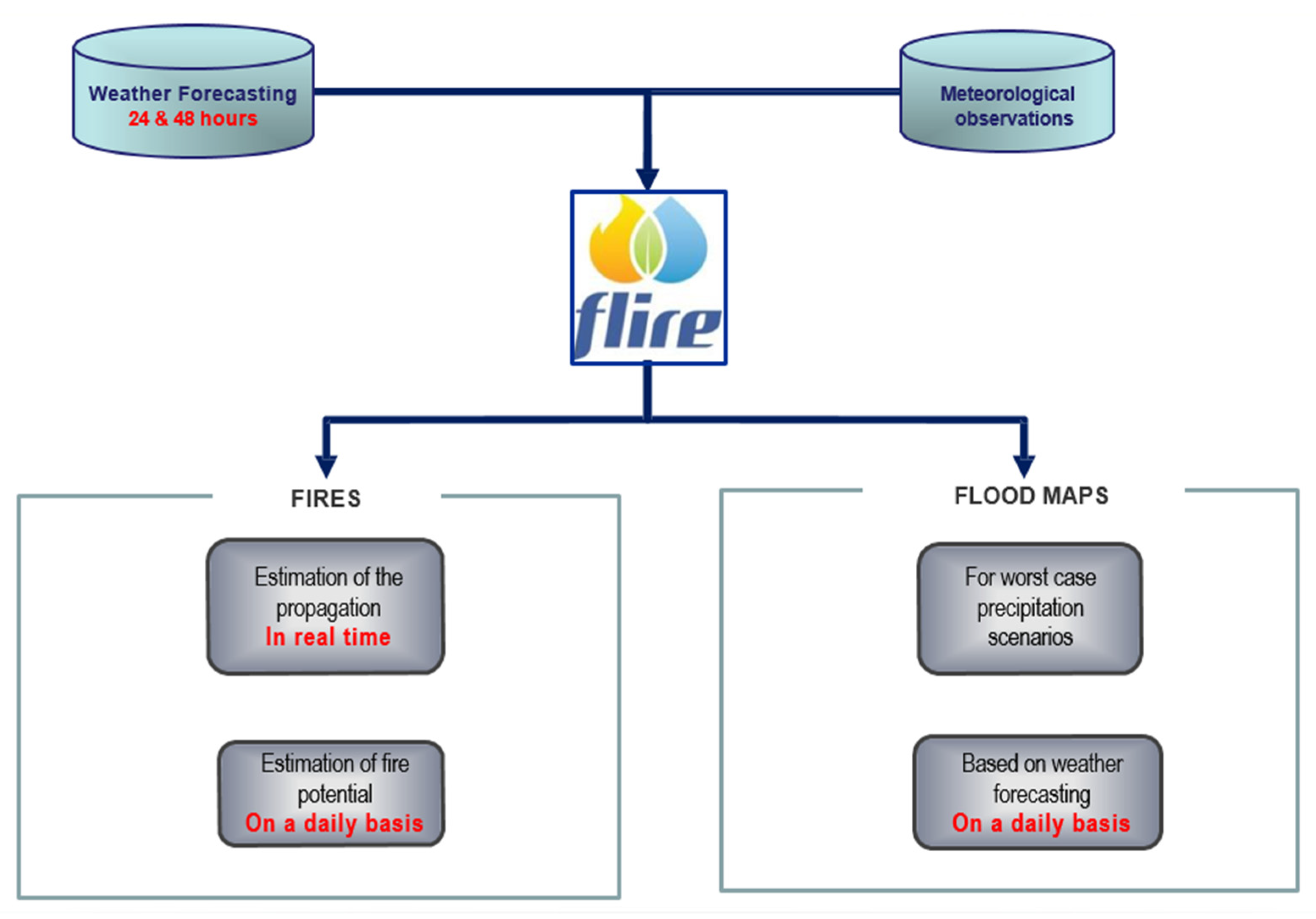
3.1. Floods and Fire Risk Assessment and Management (HOA)

An EU-funded project (LIFE11/ENV/GR/975/2012-2015) entitled “Flood and Fire Risk Assessment and Management” (FLIRE) (http://www.flire.gr, accessed on 5 March 2021) was conducted under the coordination of the National Technical University of Athens (NTUA), focusing on a typical Mediterranean peri-urban area in Eastern Attica (the Rafina Megalo Rema basin) that extends over 127 km2. The river basin area has undergone rapid and uncontrolled urbanization during the last decades and is particularly prone both to flash floods and forest fires, resulting in its gradual but dire ecological and landscape degradation.
The main challenges tackled within this project were: (i) the combined, effective and robust risk assessment and management of both flash floods and forest fires for prevention and mitigation of these severe environmental hazards and of their adverse socio-economic impacts; and (ii) the support of environmental policy and governance through the development of appropriate operational decision-supporting tools. The tools, which have been developed and successfully applied in real conditions, are the following:
(1)
A Weather Information Management Tool (WIMT) that provides short-term weather forecasting information based on the data received from the stations of the observatory and dynamically considers local conditions to classify weather conditions for potential risk of floods or fires [39].
(2)
A near-real-time flood risk assessment and management tool which includes a catchment modelling component, an urban modelling component and an Early Flood Warning System. This tool receives the flood risk information from the WIMT and activates, if necessary, the corresponding Early Warning System (EWS) [40,41].
(3)
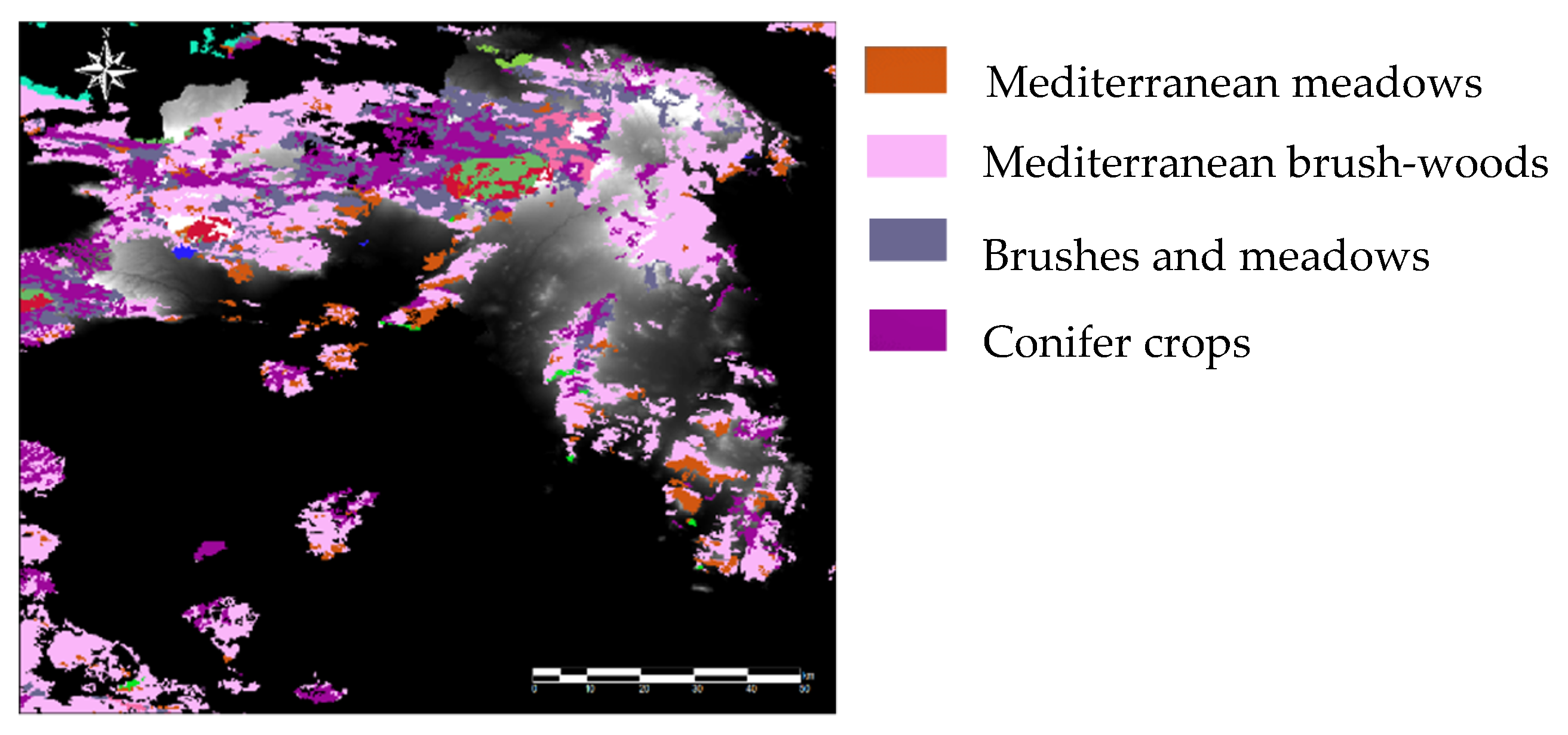
A near-real-time forest fire risk assessment and management tool which includes a fire modelling component and an Early Fire Warning System. It receives forest fire risk information (e.g., map of flammable material obtained based on naturally observed values, as shown in Figure 2), meteorological data, drought indexes, etc., and, if necessary, activates the corresponding EWS [41,42].
(4)
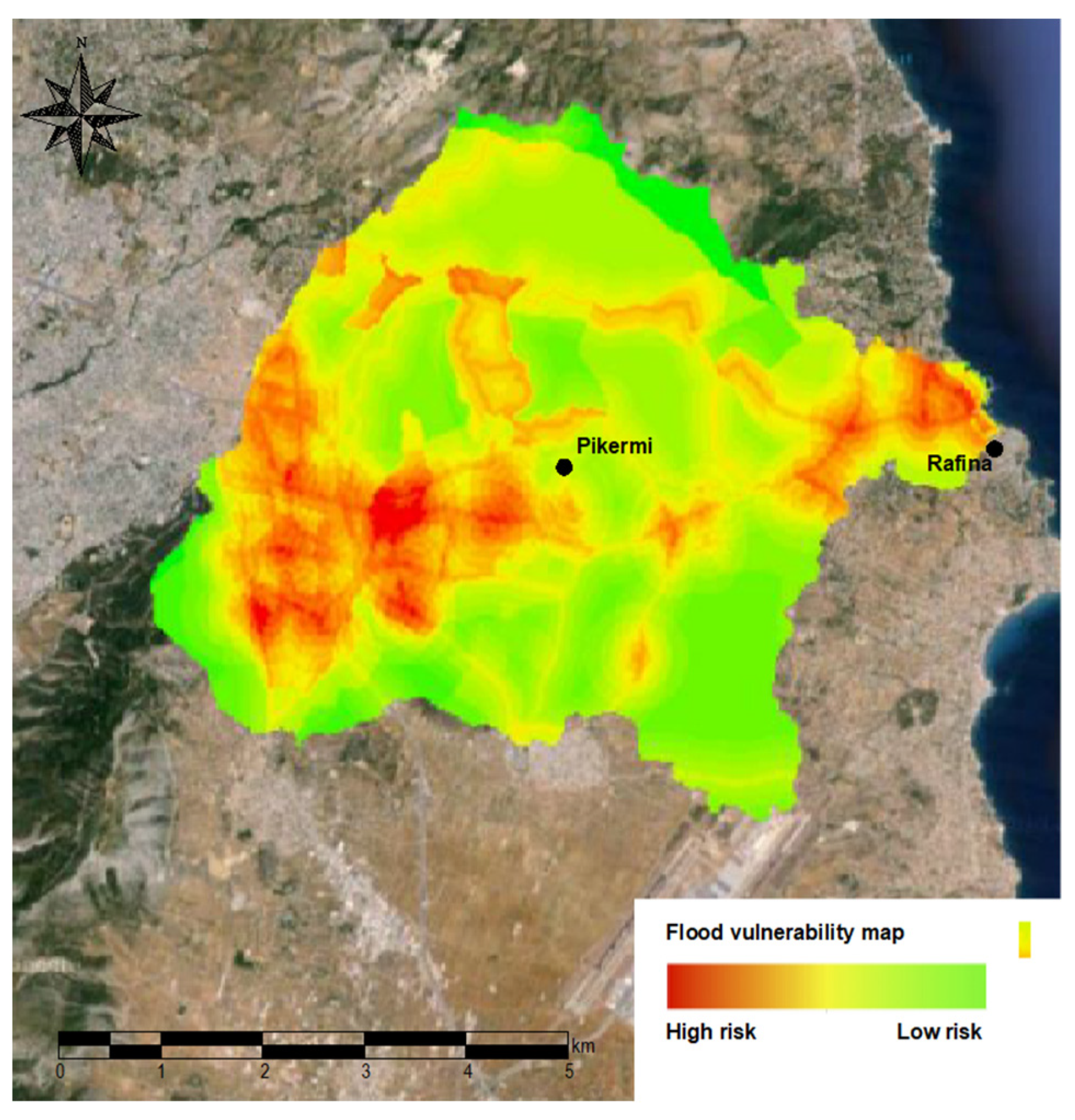
A planning tool for flood risk assessment and management, which uses the catchment modelling and urban modelling components of the near-real-time flood management tool and further integrates a component related to urban development and an optimization algorithm for mapping the flood vulnerability of the area, as shown in Figure 3, and for the flood hazard and risk management. The calibration of the post-fire conditions was based on relevant historical data and information of the broader area, as well as on reasonable modelling assumptions regarding the post-fire-induced changes on the water cycle (runoff coefficients, etc.) [40].
These components have been combined into a common system—a Decision Support System Tool—supporting decisions for integrated flood and forest fire management [41,43]. In Figure 4, an indicative schematic diagram of the web-based platform for flood and fire forecasting and warning is presented.
All developed tools are operational in real time. They have been implemented and tested successfully in Eastern Attica. The stakeholders and decision makers in the area have been trained and guided through a series of educational seminars, guide reports and manuals.

3.2. Critical Zone Science Research—Irrigation Water Management (PHO, KRB-CZO)

Rural Greece lives on agriculture and is characterized by agroecosystems of unsurpassed value and landscape beauty. Water is of essence in sustaining the environmental balance and socio-economic growth of these areas but is not always granted. Since about 85% of the total water use of Greece is utilized by agriculture, proper management of irrigation water resources is necessary, especially in the contexts of increased water stress and climate change, which call for fresh water consumption reduction and effective use.

3.2.1. Understanding Irrigation Water Use at Pinios Hydrologic Observatory

Despite the fact that sometimes it is neglected from soil water budget calculation, capillary rise can contribute significantly to crop water requirements, especially when a shallow groundwater table exists. HYDRUS-1D model was used to quantify the contribution of capillary rise to crop water requirements of five crops cultivated in Pinios Delta plain, central Greece. The model was executed for 75 different setups formulated by the five most representative soil profiles, three different groundwater table depths (1, 1.75 and 2.5 m below ground’s surface) and the five most representative crops of the study area, namely sunflower, corn, cotton, alfalfa and kiwi fruit. For all model runs, capillary rise was found to significantly increase soil water content of the rhizosphere, thus contributing to crop water needs. In the area, the contribution of capillary rise varied between 200 and 300 mm, while for the majority of model runs it was found to vary between 220 and 280 mm. Figure 5 presents cumulative capillary rise for corn cultivated in sandy loam (120 cm soil profile depth), sowed in early April and harvested in early August, while the groundwater table was assumed to be at 1.75 m depth. For this model run, capillary rise reached 211 mm for the whole growing season, while no deep-water percolation was observed. Model setup was based on exhaustive data collection and analysis and model runs do reliably reproduce water budget elements of the basin and explain and document the irrigation practices adopted by farmers in the basin, who effectively employ a Natural-Based Solution (NBS) system. The documented mechanisms have been accounted for in the proposed water resources management plans of the basin, in the framework of the AGROCLIMA GSRT project (water resources management of coastal agricultural environments, resilience of climate change impacts).
At the neighboring basin of Agia, irrigation needs are predominantly covered by groundwater abstracted from an aquifer system of limited extent and potential. To facilitate groundwater resources management and implement irrigation scheduling techniques, an Internet of Things (IoT) network of meteorological stations, soil moisture sensors and pressure transducers to measure groundwater fluctuations at production wells and water meters has been installed, amongst others, to sample at 10 min intervals. Apart from enabling accurate estimation of the aquifer system’s hydraulic parameters, data analysis allows study and understanding of the hydraulic evolution mechanisms, the impact of irrigation abstractions on groundwater reserves and the system’s response to and dependency on large hydrologic changes, such as those documented in the years 2017–2020 (Figure 6).
Annual precipitation in the period 2017 to 2020 varied from 22 to 32% between subsequent years and resulted in highly different groundwater recharge heads elevations from 3 to 23 m. In contrast, groundwater heads recession during the irrigation periods are not seen to change significantly from year to year and are sustained at ca 10–12 m. Dynamic heads (groundwater levels during abstraction) drop by 10–15 m depending on the duration of the pumping, which on average does not exceed 10–12 h. However, as high as 70 m drop of dynamic heads is documented at production wells in the basin.
Reducing abstraction rates to match the potential of each well is expected to save considerably on energy cost and prolong the life span of pumping equipment, thus improving the net profit of each crop whilst protecting the aquifer system. To the same line, it is apparent that the aquifer system responds rather quickly to hydrological changes that are expected to become acute and prolonged. Data-driven crop water demand calculations are now being performed to offer irrigation scheduling services to the farming community, aiming at cutting down on water use and optimizing efficiency. These observations are now being used to drive groundwater modelling tools in efficient resources management and forecast reserves with a view to develop climate change impact resilient agriculture, in the framework of the ongoing H2020 ATLAS project (agricultural interoperability and analysis system), and also drive NEXUS system management scenarios in the framework of the recently initiated PRIMA LENSES project (learning and action alliances for nexus environments).

3.2.2. Minimizing Irrigation Demand at Koiliaris KRB-CZO

Hydrologic and plant monitoring stations have been established in an avocado plantation to determine optimal irrigation schemes, the water use efficiency of the trees and ways to improve plant productivity. The stations consist of a precipitation and meteorological station, soil moisture profilers near and away from the tree, irrigation flow monitoring and NDVI and PRI cameras for the estimation of the above ground biomass changes. These data that are collected every 15 min, together with expert knowledge, are being used to determine optimal irrigation schemes such as deficit irrigation that will conserve the use of water as well as maximize plant production.
Drip irrigation is applied through a pipe with 1 m radius around the stem of the tree and in the traditional way where two lines of drip pipes located on either side of the tree cross the field. In this way, we irrigate a radius of 2 m around the tree or a surface area of about 12.5 m2. For a typical field of 1000 m2 which has on the average 25 trees, it means that we irrigate approximately 1/3 of the area only, minimizing in this way the irrigation demand. The meteorological data were used to apply the Pennman-Montheith equation and determine the actual evapotranspiration of the plant (Figure 7). The total amount of irrigation applied in the field has also been monitored as well as the changes in soil moisture in the top 1 m of soil. The latter data have been used to determine the evolution of the change of water volume in the top 1 m for a radius of 2 m around the tree also presented in the figure. The amount of irrigation water applied to the tree from May to October was 8720 L while the evapotranspiration was estimated to be 7852 L over the same period. The change of soil moisture was -120 L. The above data suggest that the amount of water lost to percolation and recharged groundwater was 988 L. Using pedotransfer function and the Van Genuchten equations, it was estimated that the total percolation volume was 826 L. This suggests that there is an error in the closure of the hydrologic budget which is 1.9%. This error is attributed either to the estimation of ET or percolation. In general, it is considered acceptable and this type of data can be used to determine irrigation schemes that will minimize the amount of losses and the total irrigation volume. An automated weather station can provide the daily amount of ET to the farmers and the farmer can irrigate the volume that the plant used during the days between two irrigation efforts.
Instrumented monitoring allows detailed analysis of the agricultural ecosystems and provides the tools to understand controlling hydrologic and hydraulic mechanisms, defining boundary conditions and quantifying water requirements. Upon deep knowledge and understanding of the system, justified management measures can be compiled and reliable and effective water-saving methods can be developed and implemented.

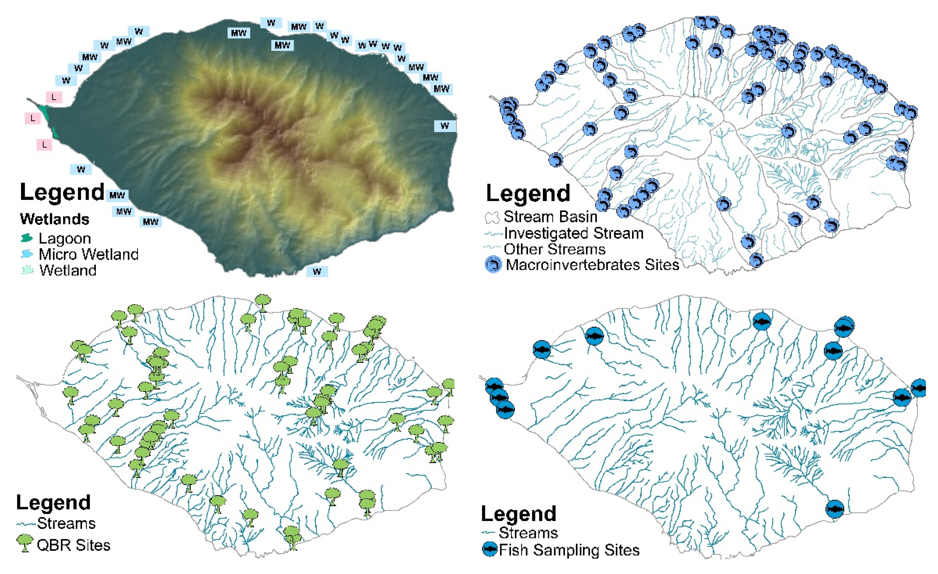
3.3. Comparative Research on Hydrology, Aquatic Quality and River Basin Management (PHO, KRB-CZO, SNO)

Variable river basin physicogeographical and land-use features affect river hydrology and water quality, leading to differing basin management plan approaches. We focused on three watersheds: (i) the Fonias (Samothraki Island, North Greece), a very small, high-altitude, rugged, nearly pristine granitic basin, where free grazing is the main pressure; (ii) the Koiliaris (Crete Island, South Greece), a medium-sized, mid-altitude, karstic basin, with intensive cultivation and heavy livestock grazing at the lowlands; and (iii) the Pinios (Central Greece), a very large, low-altitude river basin of mixed geology, featuring the most intensively exploited and highly productive agricultural plain of Greece.

3.3.1. Hydrological and Water Quality Characteristics

Fonias basin exhibits the lowest mean annual air temperature and heavy winter precipitation, including snowfall. Koiliaris basin receives high rainfall and presents high air temperature, while Pinios exhibits a continental climate, is the driest of the three basins and has air temperature that may reach 40 °C in summer. In all three basins, summer rainfall is limited. The three rivers are of the few free-flowing rivers in Greece. The Pinios is mainly fed by extensive alluvial aquifers and has a low specific discharge due to infiltration and immense irrigation use, which turned the natural water balance to strongly negative [44]. In winter, the river is prone to floods. The Koiliaris, the only permanent stream of Crete, with a typical karstic spring-fed hydrology, receives its water both from the watershed and from the extended karst outside the watershed and reveals high specific discharge and occasional flash floods [45,46]. Fonias is a bedrock-type stream, fed by numerous small and shallow fractured-type aquifers with respective springs. Limited groundwater storage capacity combined with steep morphology cause high specific discharge and severe flood events, even in summer. In summer, higher night-flow is attributed to the stressing of the Koiliaris karst’s porous matrix due to the tidal effect [46], to increased fog water contribution in Fonias [37] and to high day evapotranspiration and irrigation use in Pinios.
Differing geological background and hydro(geo)logical conditions among the three basins cause major hydrochemical differences. High groundwater contribution to Pinios river flow and, possibly, high irrigation leachates, cause very hard waters. Despite the abundance of carbonate rocks in the Koiliaris basin, the river presents medium hardness due to low retention times. Flowing rapidly through weathering resistant magmatic silicate rocks, the Fonias River shows impressively low solute concentrations and low hardness, since its composition is rather more affected by precipitation inputs than by geochemical reactions [37].
The Pinios basin annually receives hundred thousand tons of fertilizers and thousand tons of pesticides, and is subject to partly untreated municipal and agro-industrial effluent [47,48]. Nutrient pollution is particularly high along its midway section, while towards the outflow, aquatic quality gradually improves due to self-purification [49]. As shallow groundwaters illustrate dramatic nitrate levels, making them unsuitable for human consumption [50], the basin has been designated a nitrate-vulnerable zone [51,52]. Introduction of good agricultural practices may have improved recent nitrate quality, contrary to ammonium which shows annual peaks towards unacceptable levels [19]. Water quality in the Koiliaris River is impacted primarily by agricultural activities and livestock. Livestock densities are very high (8–14 sheep and goats/ha grassland) and contribute directly to the degradation of water and soil quality [25]. Agricultural impacts can be seen in the groundwater quality of the valley. In the river, close to the karstic springs, nitrate levels range between moderate and good quality (average 0.7 mg/L N-NO3), whereas ammonium may present excessive inputs in particular years (average 0.07 mg/L N-NH4). More downstream, nitrate levels further increase [46]. In Fonias, consistent with the minimally disturbed environment, high physicochemical quality predominates. The disproportionally high nitrate levels, in remote inaccessible mountainous stream reaches, were attributed to atmospheric inputs [37]. The recent ecological status (2012–2015 and 2018–2019) of the Fonias and the Pinios rivers was good and poor, respectively [19]. The Koiliaris River near its outflow revealed a moderate ecological status [53].

3.3.2. Sustainable River Basin Management Actions

River Basin Management Plans (RBMPs) under the WFD include serious drawbacks, especially regarding the Programs of Measures (PoMs) [19,20,21] and/or are inadequate for water-land management as in the case of, e.g., Samothraki Island [38].
In Pinios basin, sustainable water management should meet three preconditions; reverse the large water deficit in the basin by safeguarding the renewable water potential, restore the ecological status of the fluvial ecosystem and the chemical status of the aquifer systems and satisfy water demand. Reservoir construction (anticipated in the respective RBMP), application of hydro-technical projects and materialization of the highly controversial partial diversion of Acheloos River are not sufficient to meet these preconditions [54]. Water management plans should thus additionally consider precision agriculture techniques, deficit irrigation [55], restructuring of agriculture, currently consuming up to 95% of the total water demand, towards less water-demanding crops and use of grey water resources. In addition, the nitrate-vulnerable zone principles and waste water treatment should be better implemented and monitored to safeguard surface and groundwater quality.
The Koiliaris basin presents a positive exemption on water management; based on a long-term continuous hydrometeorological network, the hydrologic budget of Koiliaris KRB-CZO has been studied [45,46] and modeled extensively [25,27]. Even though the water budget is positive for the basin, there are water management issues that need to be addressed locally. During dry years, the flow in the major karstic springs is low and does not cover local irrigation needs. To overcome this problem, water management agencies use water from the Zourbos spring that is influenced by sea intrusion and is not acceptable for a series of produce such as avocado. Therefore, finding ways to reduce irrigation demand with new irrigation methods (see Section 3.2) and better management of water resources is of upmost importance.
Fonias River has sufficient summer flow and high ecological status to satisfy recreational and minor irrigation needs. In summer, the river seems to be predominately fed by fog condensation [37]. This process is expected to be affected by climate change and/or development projects, such as the anticipated installation of industrial wind parks on the island’s mountain ridge. Heating and drying of the near-surface air masses by wind turbine operation is expected to affect vapor condensation processes, thus reducing spring and stream flow and threatening at least 7 of the 17 endemic flora species of the island [56]. Another urgent issue to be solved on a governmental level concerns the reduction of the number of free-grazing goats that reduce vegetation, causing dramatic erosion [36,57]. Finally, additional efforts should be devoted to restoring the remaining forests of the river basin (see Section 3.4).

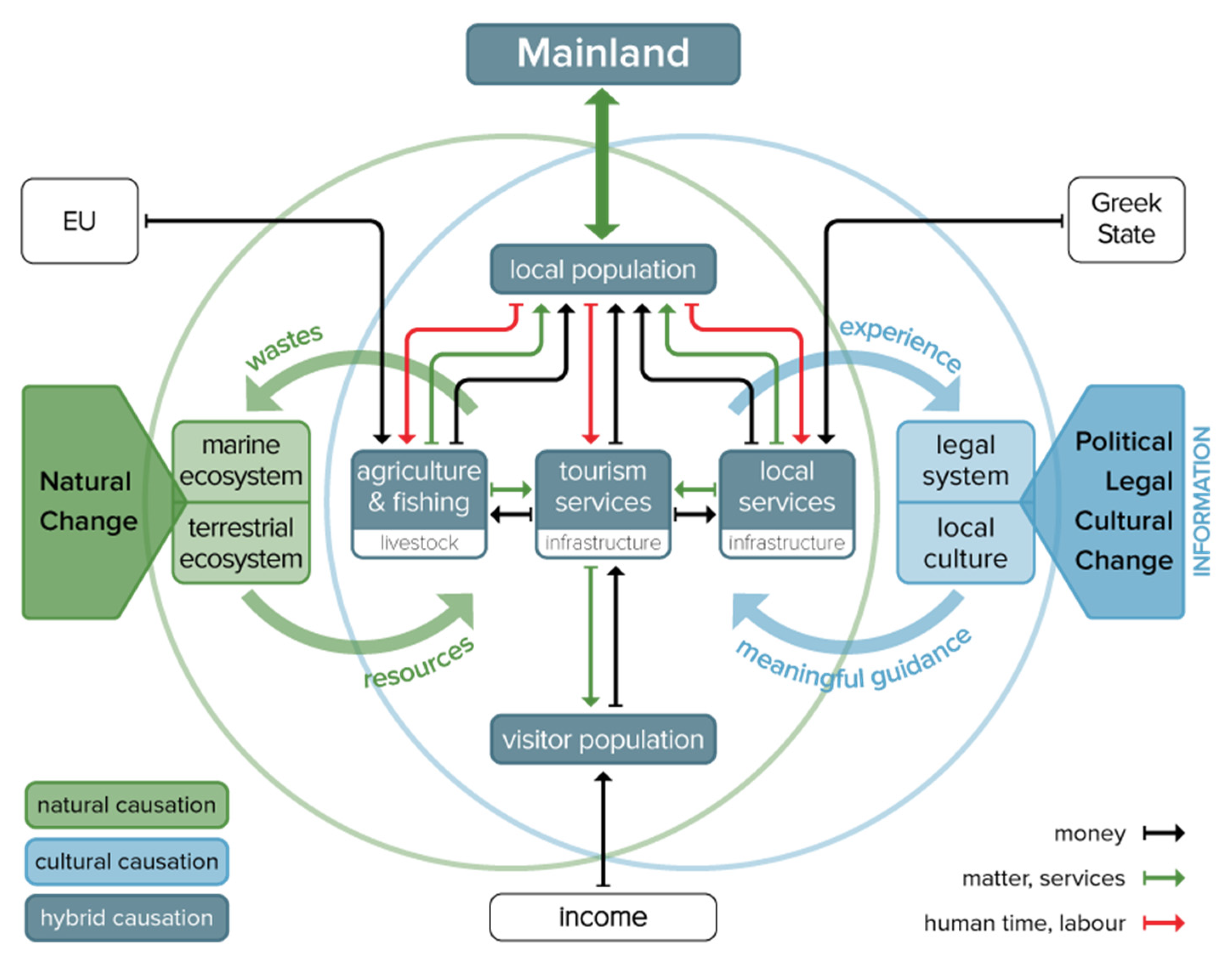
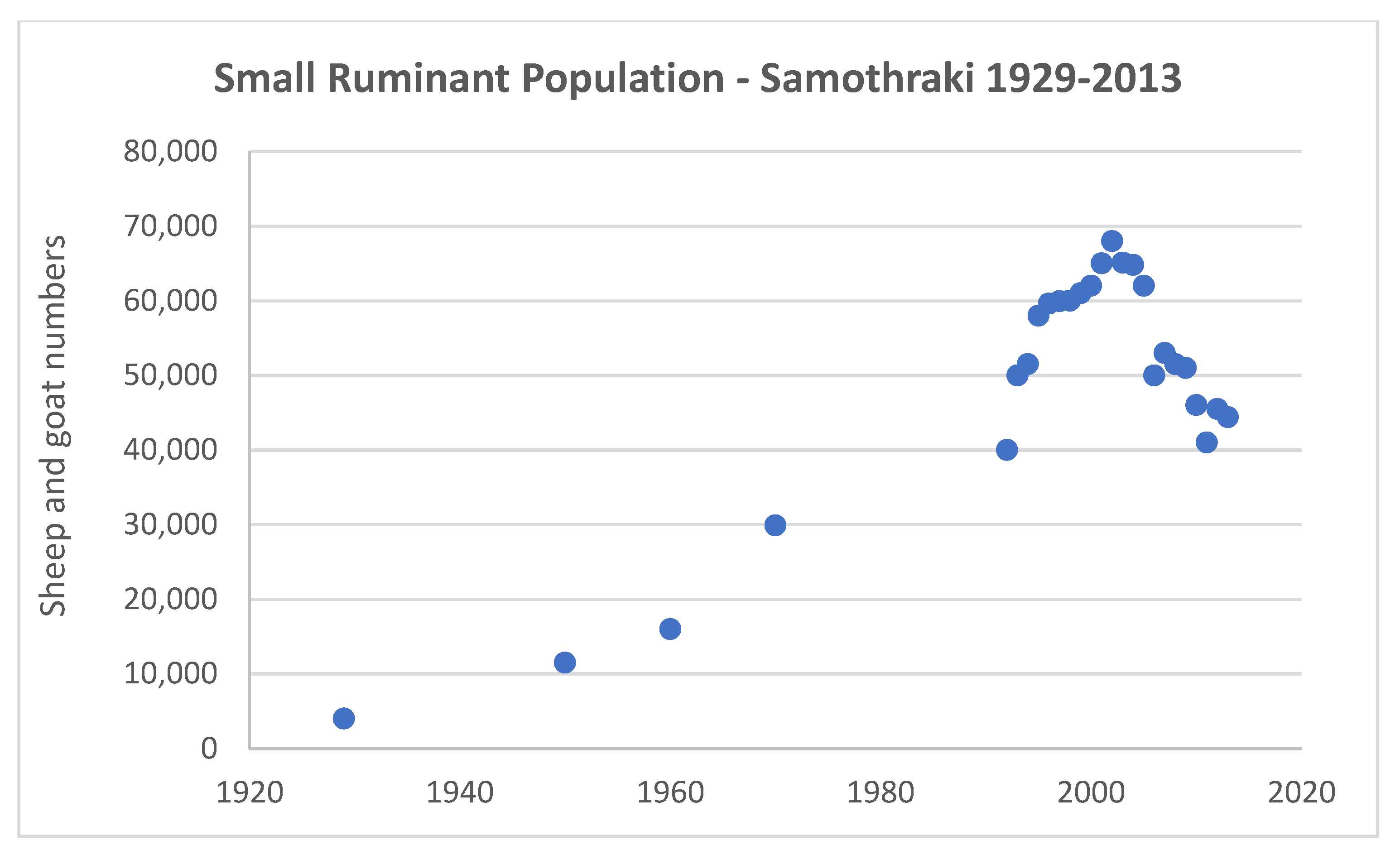
3.4. Socio-Ecological Research—Stakeholder Involvement in Land and Water Management (SNO)

Transdisciplinary socio-ecological research since 2007, financed by the Austrian Academy of Sciences and the Austrian Science Fund, created a research agenda that aims at supporting the inhabitants of Samothraki and their administration in achieving practical sustainable development goals. Conceptually, the research is guided by the framework of social metabolism and also involves “citizen science” activities to help make the local people aware of the challenges the island faces (http://sustainable-samothraki.net/, accessed on 4 March 2021). Our activities prepared the ground for an application in 2011, that was resubmitted in 2013 to UNESCO, for Samothraki to be included in the World Network of Biosphere Reserves (BRs), unanimously supported by the Mayor and the Municipal Council and with wide resonance in the local community [58,59].
One further key outcome of this continuous work and communication efforts was the legal establishment of the local association “Sustainable Samothraki” for assuming a role in the future BR management and promoting local sustainability initiatives. Our activities over the past years have been highly acknowledged, including the Sustainability Award 2010 received by the Austrian Ministry of Science and Research, and the Honorary Citizenship that Marina Fischer-Kowalski received from the Municipality of Samothraki in 2012 for her long-standing and sustained efforts to transform the island into a Biosphere Reserve.
Over the years, a strong research presence on the island has been consolidated. A focus on the practical implementation of local projects is supported by several PhDs and Master’s theses on diverse issues (social metabolism, water and waste management, tourism, land use, overgrazing, agriculture, food preferences, social services, island biodiversity), and since 2012 has been complemented by yearly on-site summer schools in social and aquatic ecology, in collaboration with HCMR and several universities, local and national authorities and NGOs, as well as key UNESCO branches. These summer schools typically include extensive rounds of explorative and visioning focus group interviews with different local stakeholder groups, where results are fed back to the community, and are planned in such a way as to achieve maximum synergistic effects between research and policy goals [60,61,62,63]. These achievements and consistent communication efforts have created a committed scientific “capital” in support of the BR nomination.

3.4.1. Social Ecology/Research Approach

In assessing the development trajectory of a socio-ecological system and exploring transition pathways towards a more sustainable future, one needs to account for biophysical flows, but also understand the social structures that support these flows. The concept of social metabolism [64,65] provides a framework for this, as it incorporates the natural and social systems and focuses on the interaction between them, in particular on the social activities which have a direct material impact on the ecosystem (Figure 8). The socio-metabolic approach takes society as the unit of analysis, interpreted as a socio-economic system that interacts with systems in the natural environment.
The ability of Samothraki’s socio-ecological system to reproduce itself depends on whether flows required for maintaining the stocks can be organized. When critical stocks cannot be reproduced, the system might “collapse”. To strive towards sustainability, in this context, means to develop and maintain a social metabolism that serves the needs of the people without destroying the ecological balances of the natural environment, while being resilient to changing contexts. This means to not increase socio-economic stocks excessively, to use natural resources carefully and efficiently and evolve towards a circular economy, to create effective synergies between the sectors of the economy (such as agriculture and tourism) and to develop a culture of social responsibility, collaboration and fairness.

3.4.2. Achievements/Successes

A new future for farming is formulated protecting local communal lands, while providing sustainable products for tourism and the wider market. Much of our policy efforts have targeted the pressing issue of overgrazing on the island, in an effort to find drastic ways to achieve better utilization of the sheep and goat population, i.e., reaching the same productivity with a substantially reduced number of animals, while finding synergies between the main economic sectors of the economy, agriculture and tourism [67]. According to previous analyses [57], there is a mismatch between the available grazing land and the livestock number, leading to severe overgrazing and loss of vegetation cover [68].
Successful experiments with permanent sown biodiverse pastures (SBP) are conducted. These seed mixtures of common Mediterranean plants have been developed by the Lisbon Technical University in partnership with Terraprima to successfully combat soil erosion in overused pastures in Portugal. The practice supports biodiversity and enhances productivity through the high presence of legumes in the seed mixtures. SBPs improve the physical and chemical properties of the soil and can play an important role in preventing soil erosion [69,70,71]. Trials demonstrated that Samothraki provides excellent conditions for SBP. To date, SBP has been implemented on 15 parcels in different locations, involving several farmers. The pastures developed with high productivity and excellent fodder quality and are supposed to do so for the next decade without further interventions. Moreover, in collaboration with IT firm Integrated ITDC, the Aristotle University of Thessaloniki and the Leibniz Centre for Agricultural Landscape Research, we have been involved in the development of the “Happy Goats App”, a decision support tool for farmers to better plan on their animal numbers and their use (http://happygoats.eu, accessed on 4 March 2021).
An oak forest rejuvenation/protection experiment is conducted in collaboration with local farmers. The Quercus petraea subsp. polycarpa forests of Samothraki are in a critical condition: 85% of the remaining forests have a high restoration priority while 65% are solely composed of very old trees approaching or at the end of their life span. Particularly, forest stands in higher altitudes (1000–1400 m) are endangered and show an urgent need for restoration. Overgrazing by goats was identified as the main obstacle to successful regeneration of the oak forests [72]. Without changes in land-use intensity and measures for restoration, these forests will be lost within the next three decades. As Figure 9 indicates, our efforts so far have contributed to a 30% reduction in the number of small ruminants, and a certain recovery of the vegetation [68]. The ancient oak forests in higher altitudes remain in a critical state [72] and local citizens, and in particular livestock farmers, need to recognize and start taking care of them. Financial rewards for farmers taking care of certain areas of forest regrowth are envisioned.
Socio-economic assessment of tourism was performed in 2007 and repeated in 2015, through an extensive survey of visitors, their behavior and preferences, including a Willingness to Pay survey and a first outline of economic models for tourism, as well as comprehensive consultations with stakeholders regarding sustainable tourism and possible integrations with other productive sectors of the local economy. Some of our main ideas and propositions [73], like the improved accessibility with passenger ferries, are finally materializing. A detailed plan for the most frequented (up to 2000 campers per day in the main season) but still not legalized camping ground, has been developed, introducing a constructed wetland for waste water cleaning and including a realistic investment plan. Decision making on the part of the municipality is pending.

3.5. Biodiversity Research (LES, SNO, NEO, SAM)

Four of the LTER sites show case examples of biodiversity knowledge development and monitoring; a synopsis from Lesvos (LES), Samothraki (SNO), Navarino (NEO) and Samaria (SAM) observatories is presented here. The four reviewed LTER sites have very different institutional structures and approaches to research and long-term monitoring efforts. One of the sites, Samaria, is a wilderness-dominated national park with long-term institutional support and an active management body; two of the remaining observatories include important Natura 2000 sites of outstanding biodiversity interest, which only recently gained management body support (NEO, SNO); the fourth site is a fairly large heterogeneous island (Lesvos) with an active university-supported multidisciplinary research structure. It is difficult to compare the four observatories; however, preliminary insights and development patterns can be gleaned from the efforts made at each one of them.
The island of Lesvos, the third largest Greek island, is a special study place for field biology and ecology for both its renowned natural heritage and historic aspects. First, because of its historic distinction as being the birth place of Theophrastus and one of the study areas of his master, Aristotle, in the 4th century BC. Both these historical figures made world-renowned natural history discoveries on this very island and wrote famous interpretive texts [74]; Lesvos is therefore considered to be the birthplace of the discipline of Biology. Yet, Lesvos is a continental island, located just off the western Anatolian coast in the northeast Aegean, hosting many Asian biota assemblages not to be found anywhere else in Europe. The island is remarkably rich in landscape diversity with an outstanding geological mosaic characterized by various coastal zones, many wetlands and mountain areas reaching 996 m a.s.l. The rich biodiversity is exemplified by its birds; over 330 bird species have been recorded, while there are many species of invertebrates, rare reptiles and amphibians, as well as mammals; the island is also famous for its rich flora, including an impressive diversity of ground orchids [75,76,77]. An asset for the island’s biodiversity is its bee diversity: a comparative study with five other European areas showed a much higher number of bees on Lesvos [78,79], the total number exceeding 600 species for the island alone (Petanidou et al., unpublished data of the Melissotheque of the Aegean). Finally, Lesvos is an island of unique geological and landscape elements, many of them still well preserved, although some of them are threatened by land-use changes. Efforts for conservation have spearheaded initiatives such as the designation of geotopes, promoted by the Natural History Museum of the Lesvos Petrified Forest, which is located at Sigri in the western part of the island [80].
The establishment of the University of the Aegean at Mytilene (1984) with strong Departments in Environmental Studies, Marine Sciences and Geography has given this island a special boost in biodiversity and environmental research, especially after the mid-1990s. Established by the University of the Aegean originally as an ALARM Field-Site-Network site in the frame of the European FP6 ALARM project (2004–2008), the Lesvos Biodiversity Observatory (LES) hosts research on the following sectors: landscape and land use; natural, man-made and agricultural ecosystems; wetland and marine systems; conservation of natural resources; plant and animal biodiversity, particularly of insects, including pollinators. Some of the work is integrated, combining effort to track landscape change, including human-induced ecosystem alterations and biodiversity (e.g., [81,82]). Other work also includes the human element in specific habitat types (e.g., [83]). Due to Lesvos’s attractive location and rich biodiversity, the island has become a unique hotspot for ecological and biodiversity research, attracting many research teams from other countries.
Samothraki is a very small, but mountainous island, since it presents the highest island peak in the North Aegean Sea (1611 m a.s.l.), with a small permanent population, very different from the much larger and varied Lesvos, but also having a high degree of isolation, also being very close to the Greek-Turkish border. Due to its rather well-preserved cultural landscapes, including upland and coastal natural areas, the island maintains many authentic elements, resembling the “Greece of yesterday” [84] and has become especially attractive to visiting researchers from abroad for at least two decades [85]. Much of the research has included biodiversity inventory and has especially been focused on policy-relevant and integrative socio-ecological initiatives [11]. In terms of biodiversity, research depends largely on the visiting scientists, academic organizations and a few specialist NGOs; it is still in the inventory stage but some interesting natural history distinctions are being made and integration is in progress here too. The island is unique in the Aegean for supporting one of the largest road-free wilderness areas in Greece [22], so much of it is difficult to explore. Currently, there is a good compilation of aquatic benthic macroinvertebrate assemblages in the island’s many streams [33,34] and the flora and vegetation have been well documented [85]. Aspects of the island’s marine environment and its birdlife are being compiled by visiting researchers during the recent summer schools set up within the collaborative partnership for volunteer research. Other aspects of the biota are also being explored, mapped and assessed; some were monitored during the last decade (Figure 10). Integrated works aim to assess degradation by human pressures, including aspects of vegetation and other elements of biodiversity (e.g., [57]). Despite interest and active engagement of many keen local stakeholders, concrete conservation actions have fallen behind due to poor state support of the management of the island’s two Natura 2000 sites; these cover the majority of the land area and much of the surrounding seas. Biodiversity studies seem to thrive within organized protected areas but at Samothraki the two Natura sites have no management plans or finalized conservation management zonation yet.
In the southwestern Peloponnese, a new venture has been established through the development of the integrated tourism area just north of historic Navarino Bay. This part of the Peloponnese peninsula includes the Gialova Lagoon wetland area, remarkable for its birdlife since it represents one of the southernmost European wetlands along the coast of the Ionian [86]. Monitoring birds here began in the late 1990s [87,88], while NEO started its full operation in 2009 and has already become a hub for collaborative research and education for many scientists, including biodiversity experts.
The Gialova Lagoon system has a very interesting cultural landscape topography with many important conservation opportunities [89]. Several scientists have looked into aspects of water management and its effect on biodiversity needs at this site. New approaches are being used to develop an integrative investigation into landscape change, assessment, evaluation [90,91] and future steps for conservation management. As with many other important Natura 2000 sites in Greece, this area was not included in the initial Management Bodies set up in the early 2000s and it entered a management body only in 2019. New reforms for management are underway but progress is very slow.
Finally, one of Greece’s most important national parks is Samaria, in Southwestern Crete. It is defined by the remarkable gorge creating an 18 km defile across the Lefka Ori Mountains. It was declared a National Park after the Royal Decree 781 in 1962 and since then, Samaria has become one of the most celebrated protected areas in Greece. Its many distinctions include the European Biogenetic Reserve (1971), European Diploma of Protected Areas of the Council of Europe (1979), UNESCO Biosphere Reserve (1981) and European Site of Community Importance (i.e., Natura 2000 site, GR4340014). The park includes extensive wilderness and this character has been enforced since its designation. A unique quality of Samaria Gorge National Park, in contrast to the trends in early national park creation in Europe, is that when the park was declared, the few inhabitants of Samaria village were driven out of the area (and financially compensated) and nearly all productive activities within the core of the park were prohibited. As a result, a gradual re-wilding has taken place. The natural vegetation cover and local wild goat numbers have increased as have some wild plant and other animal species; in general, the biodiversity and geodiversity characteristics of the park have not been negatively altered for nearly six decades.
What is especially interesting is the large number of tourists descending on the world-famous Samaria Gorge trail. The trail is open from May to October and visitor numbers have reached about 150,000 to 200,000 per year in the last two decades [92]. In 1990, the park reached its maximum number of visitors per year, ca 300,000, and despite halving of visitors since then, Samaria is still one of the top three tourist attractions on Crete [92]. Due to much external interest, especially by many foreign investigators, the area has been well researched, particularly for its animal and plant life. Many interesting projects, including academic field courses, have been taking place there since the mid-1980s [93].
Management of the core area of the park (Gorge of Samaria) may have a long history, but there has been an ongoing expansion and reforms taking place in recent years. The operation of the Management Body of the expanded Samaria-Western Crete National Park (MB) began in 2008. The official declaration of the new National Park (Lefka Ori) is pending. The new National Park is divided into five different management zones: core zone, species habitats, ecological landscape, traditional landscape and natural resources (transition zone). Projects implemented by the MB include: (a) pine tree necrosis sampling investigation (since 2007); (b) climate monitoring based on three meteorological stations installed at the Park in 2012; (c) documentation and monitoring program of habitats and species in the National Park (2013–2015), while the second monitoring period is currently under implementation and will last until 2023. Many special operational projects are being developed, including an initiative to determine key indicators in the main sectors (natural environment, population, economy, research) that should be monitored to assess long-term effectiveness of the protected area’s management.

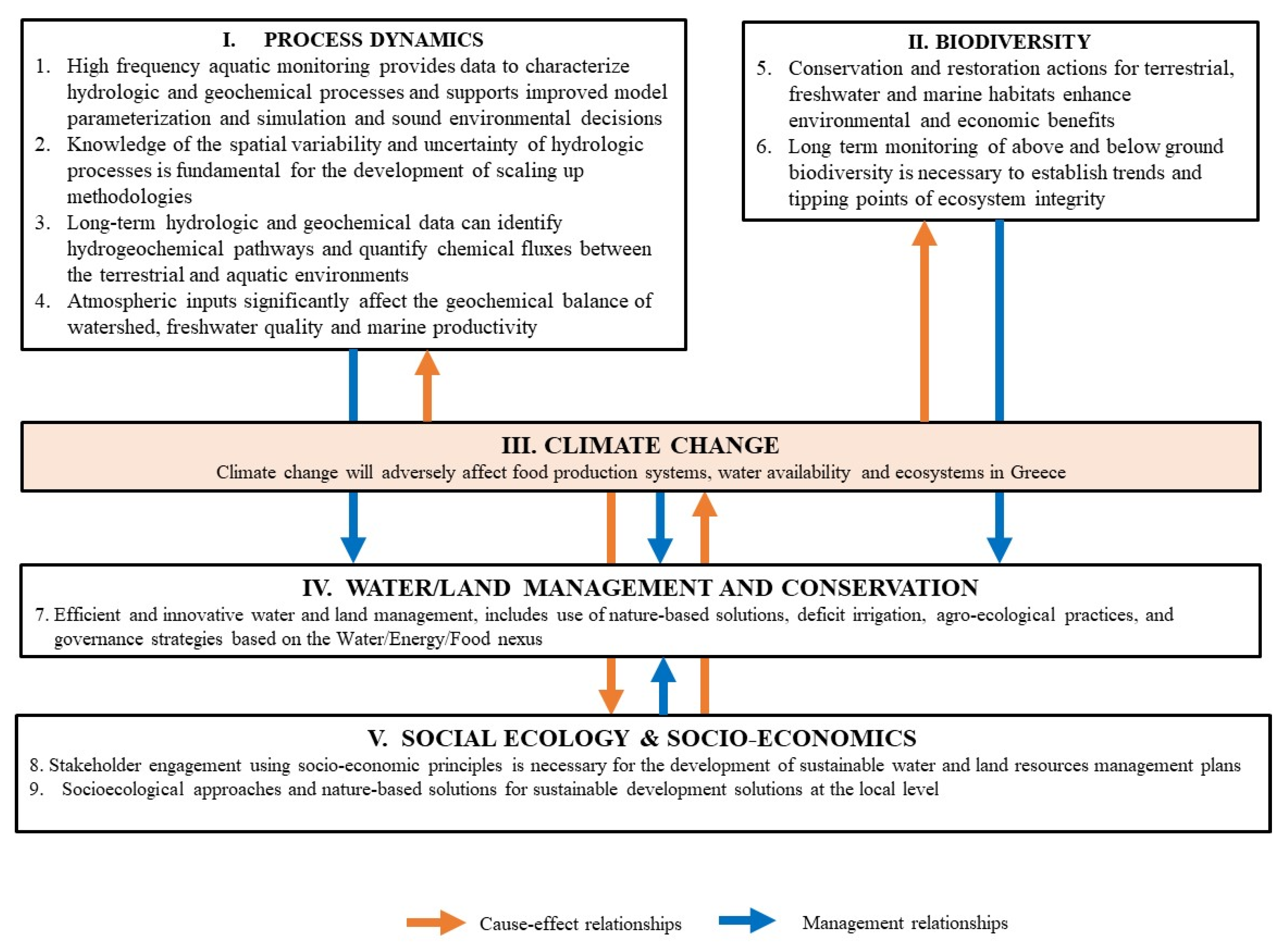
4. Discussion and Conclusions

The case studies presented above provide a glimpse of the type and relevance of the research the LTER-Greece observatories can provide in order to identify and stimulate sustainable management practices for water, land and ecosystems. The eight observatories focus on both common and differing research topics, thus being both cooperative and complementary. To broaden synergies and research perspectives, LTER-Greece is currently approaching new potential partners with appropriate infrastructure.
The Greek LTER network has not yet received any funding from the government and this is a significant structural difference with other European networks which receive permanent governmental funding. Thus, a major challenge of LTER-Greece is to strengthen its efforts to allocate resources to improve the monitoring infrastructure and activities of the individual observatories in the coming years.
The Network has identified nine research hypotheses (presented in Figure 11) that will be used to guide research and contribute to achieving the ultimate objective which is sustainable management of land and aquatic resources and promotion of ecosystems and biodiversity. These research hypotheses have been framed around five research themes that deal with climate change, environmental management, socio-ecology and economics, biodiversity and environmental process dynamics.
Wars, political and economic instability, long-term inefficient public sector, high bureaucracy, inadequate enforcement of environmental legislation and insufficient environmental awareness were the main reasons for neglecting environmental monitoring and research, and preventing a thorough inventory of habitat types and species in Greece [17,18], while recent economic growth has often been achieved at the expense of environmental conservation [22,23]. Today, environmental monitoring is accomplished by various ministries, public agencies and academic and research institutions, while each network density, the time-step and the period of the measurements depended on the corresponding special needs and funding [94]. Thus, data series are incomplete and are temporally and geographically fragmented.
Long-term monitoring is a fundamental prerequisite for understanding hydrologic, biogeochemical and ecological processes, assessing the impacts of climate change on ecosystems and devising sustainable management practices for terrestrial and aquatic ecosystems. The eight LTER observatories provide a basis for exceptional monitoring efforts and strong connections to national datasets (i.e., the National databank for hydrological and meteorological information—Hydroscope; NTUA, the meteorological/hydrological databanks of the National Observatory of Athens and the Public Power Corporation and the datasets of the National WFD Monitoring Program; HCMR-DEMETER) to meet the most important environmental challenges that Greece is facing today and in the near future, i.e., to adapt and mitigate the impacts of climate change, reduce point and diffuse pollution, and engage in sustainable spatial planning and management of its resources, considering natural water retention measures and nature-based solutions to improve biodiversity and enhance ecosystem services [21].
Climate change forecasting scenarios in Greece predict an increase of mean annual temperature between 3.5 and 4 °C, a drop of rainfall between 5 and 19% and a sea level rise between 0.2 and 2 m by the end of the 21st century, along with an increase in frequency and duration of extreme events, including floods and droughts [95]. Considering risk and vulnerability analysis, LTER-Greece proposes and prioritizes appropriate technologies and policies for sectoral adaptation at local, regional and country level, particularly focusing on sustainable management of agriculture, forestry, biodiversity and ecosystems, land, water resources, coastal zones and structured environment.
As 75% of the terrestrial environment, 40% of the marine environment and 50% of rivers and streams are severely altered due to human activity, biodiversity is globally declining at rates unprecedented in human history and the rate of species extinctions is accelerating, with major impacts on goods and services provided by nature and major consequences for people around the world [96]. In Greece, many new pressures and land-use changes threaten both its natural and cultural landscapes. For example, alternative energy projects, including small hydropower and industrial wind farms, have recently been widely developed within many protected and remote ecosystems facing the paradox of negatively impacting biodiversity in the name of combating climate change [24]. These major challenges require evidence-based study and strategic planning.
LTER-Greece adopts, develops and implements state-of-the-art interdisciplinary methodologies for assessing the environmental impacts of development activities, and to understand underlying mechanisms and design targeted management and conservation measures. As land use is identified as the top threat for biodiversity decline worldwide [97], land management should be in line with environmental conservation and inspired by nature-based solutions to preserve ecosystem integrity and natural heritage.

Author Contributions

Conceptualization, N.P.N., N.T.S., A.P., S.Z. and M.M.; Structure Design, N.T.S., N.P.N., A.P. and M.M.; Data Provision, N.T.S., N.P.N., M.M., A.P., M.F.-K., P.P., V.P., S.Z.; Data Analysis, N.T.S., N.P.N., M.M., A.P., V.P. and D.E.; Writing—Original Draft Preparation, N.T.S., N.P.N., A.P., M.M., M.F.-K., P.P. and S.Z.; Writing—Review and Editing, N.T.S., N.P.N., A.P., T.P., M.F.-K., S.Z., P.P., G.M. and N.M.; All authors have read and agreed to the published version of the manuscript.

Funding

This research received no external funding.

Institutional Review Board Statement

Not applicable.

Informed Consent Statement

Not applicable.

Data Availability Statement

Data included in this study may be accessed from the authors of this manuscript.

Acknowledgments

The authors of this article wish to thank Anastasia Lampou for assistance within the framework of the LTER and support of the Samothraki Nature Observatory.

Conflicts of Interest

The authors declare no conflict of interest.

References

  1. Boretti, A.; Rosa, L. Reassessing the projections of the World Water Development Report. NPJ Clean Water 2019, 2, 15. [Google Scholar] [CrossRef]
  2. Fukase, E.; Martin, W. Economic growth, convergence, and world food demand and supply. World Dev. 2020, 132, 104954. [Google Scholar] [CrossRef]
  3. Valin, H.; Sands, R.; Van Der Mensbrugghe, D.; Nelson, G.C.; Ahammad, H.; Blanc, E.; Bodirsky, B.L.; Fujimori, S.; Hasegawa, T.; Havlik, P.; et al. The future of food demand: Understanding differences in global economic models. Agric. Econ. 2014, 45, 51–67. [Google Scholar] [CrossRef]
  4. Van Ruijven, B.J.; De Cian, E.; Wing, I.S. Amplification of future energy demand growth due to climate change. Nat. Commun. 2019, 10, 2762. [Google Scholar] [CrossRef] [Green Version]
  5. UN–Water. Summary Progress Update 2021: SDG 6—Water and Sanitation for All; Version: 1 March 2021; United Nation: Geneva, Switzerland, 2021. [Google Scholar]
  6. UN–Environment. Global Environmental Outlook. Summary for Policymakers; Cambridge University Press: Cambridge, UK, 2019. [Google Scholar] [CrossRef] [Green Version]
  7. Rockström, J.; Steffen, W.; Noone, K.; Persson, A.; Chapin, F.S.I., III; Lambin, E.; Lenton, T.M.; Scheffer, M.; Folke, C.; Schellnhuber, H.J.; et al. Planetary boundaries: Exploring the safe operating space for humanity. Ecol. Soc. 2009, 14, 32. Available online: http://www.ecologyandsociety.org/vol14/iss2/art32/ (accessed on 17 February 2021). [CrossRef]
  8. IPCC. Climate change 2014: Synthesis report. In Contribution of Working Groups I, II and III to the Fifth Assessment Report of the Intergovernmental Panel on Climate Change; Core Writing Team, Pachauri, R.K., Meyer, L.A., Eds.; IPCC: Geneva, Switzerland, 2014; p. 151. [Google Scholar]
  9. Mirtl, M.; Borer, E.T.; Djukic, I.; Forsius, M.; Haubold, H.; Hugo, W.; Jourdan, J.; Lindenmayer, D.B.; McDowell, W.; Muraoka, H.; et al. Genesis, goals and achievements of long-term ecological research at the global scale: A critical review of ILTER and future directions. Sci. Total Environ. 2018, 626, 1439–1462. [Google Scholar] [CrossRef] [PubMed]
  10. Singh, S.J.; Haberl, H.; Chertow, M.; Mirtl, M.; Schmid, M. Long Term Socio-Ecological Research: Studies in Society-Nature Interactions Across Spatial and Temporal Scales; Springer Science & Business Media: New York, NY, USA, 2013; Volume 2. [Google Scholar]
  11. Fischer-Kowalski, M.; Löw, M.; Noll, D.; Petridis, P.; Skoulikidis, N. Samothraki in transition: A Report on a Real-World Lab to promote the sustainability of a Greek Island. Sustainability 2020, 12, 1932. [Google Scholar] [CrossRef] [Green Version]
  12. Petridis, P.; Fischer-Kowalski, M.; Singh, S.J.; Noll, D. The role of science in sustainability transitions: Citizen science, transformative research, and experiences from Samothraki island, Greece. Isl. Stud. J. 2017, 12, 115–134. [Google Scholar] [CrossRef]
  13. Griffiths, H.I.; Kryštufek, B.; Reed, J.M. (Eds.) Balkan biodiversity. In Pattern and Process in the European Hotspot; Kluwer Academic Publishers: Dordrecht, The Netherlands, 2004; p. 332. ISBN 978-1-4020-2854-0. [Google Scholar]
  14. OECD. Environmental Performance Reviews: Greece. 2020. Available online: https://www.oecd-ilibrary.org/sites/cec20289-en/1/3/1/index.html?itemId=/content/publication/cec20289-en&_csp_=f78b6fdf8ec3ba726ca305d6c10debcf&itemIGO=oecd&itemContentType=book (accessed on 15 February 2021).
  15. EC. The EU environmental implementation review 2019. In Country Report—Greece; European Union: Maastricht, The Netherlands, 2019; p. 32. [Google Scholar]
  16. Skoulikidis, N.; Dimitriou, E.; Karaouzas, I. Preface. In The Rivers of Greece: The Handbook of Environmental Chemistry; Skoulikidis, N., Dimitriou, E., Karaouzas, I., Eds.; Springer: Berlin/Heidelberg, Germany, 2018; pp. xi–xii. ISBN 978-3-662-55369-5. [Google Scholar]
  17. Legakis, A.; Maragou, P. (Eds.) The Red Book of Endangered Animals of Greece; Hellenic Zoological Society: Athens, Greece, 2009; p. 528. (In Greek) [Google Scholar]
  18. Skoulikidis, N.; Zogaris, S.; Karaouzas, Y. Rivers of the Balkans. In Rivers of Europe, 2nd ed.; Tockner, K., Zarfl, C., Robinson, C.T., Eds.; Elsevier: Cambridge, MA, USA, 2021; ISBN 9780081026120. [Google Scholar]
  19. Skoulikidis, N.; Karaouzas, I.; Amaxidis, Y.; Lazaridou, M. Impact of EU environmental policy implementation on the quality and status of Greek rivers. Water 2021, 13, 1858. [Google Scholar] [CrossRef]
  20. Kanakoudis, V.; Tsitsifli, S.; Azariadi, T. Overview of the river basin management plans developed in Greece under the context of the water framework directive 2000/60/EC focusing on the economic analysis. Water Resour. Manag. 2015, 29, 3149–3174. [Google Scholar] [CrossRef]
  21. Kagalou, I.; Latinopoulos, D. Filling the gap between ecosystem services concept and river basin management plans: The case of Greece in WFD 20+. Sustainability 2020, 12, 7710. [Google Scholar] [CrossRef]
  22. Kati, V.; Kassara, C.; Psaralexi, M.; Tzortzakaki, O.; Petridou, M.; Galani, A.; Hoffmann, M.T. Conservation policy under a roadless perspective: Minimizing fragmentation in Greece. Biol. Conserv. 2020, 252, 108828. [Google Scholar] [CrossRef]
  23. Lekakis, J.N. Environmental management in Greece and the challenge of sustainable development. Environmentalist 1995, 15, 16–26. Available online: https://link.springer.com/article/10.1007%2FBF01888886 (accessed on 12 February 2021). [CrossRef]
  24. Kati, V.; Kassara, C.; Vrontisi, Z.; Moustakas, A. The biodiversity-wind energy-land use nexus in a global biodiversity hotspot. Sci. Total Environ. 2021, 768, 144471. [Google Scholar] [CrossRef] [PubMed]
  25. Nikolaidis, N.; Bouraoui, F.; Bidoglio, G. Hydrologic and geochemical modeling of a karstic Mediterranean watershed. J. Hydrol. 2013, 477, 129–138. [Google Scholar] [CrossRef]
  26. Nerantzaki, S.; Nikolaidis, N.P. The response of three Mediterranean karstic springs to drought and the impact of climate change. J. Hydrol. 2020, 591, 125296. [Google Scholar] [CrossRef]
  27. Nerantzaki, S.; Nikolaidis, N.P.; Hristopoulos, D. Estimation of the uncertainty of climate change hydrologic predictions at the Koiliaris Critical Zone Observatory. Sci. Total Environ. 2020, 717, 137131. [Google Scholar] [CrossRef] [PubMed]
  28. Baltas, E.A.; Dervos, N.A.; Mimikou, M.A. Research on the initial abstraction–Storage ratio and its effect on hydrograph simulation at a watershed in Greece. Hydrol. Earth Syst. Sci. Discuss. 2007, 4, 2169–2204. [Google Scholar] [CrossRef] [Green Version]
  29. Baltas, E.A.; Dervos, N.A.; Mimikou, M.A. Technical Note: Determination of the SCS initial abstraction ratio in an experimental watershed in Greece. Hydrol. Earth Syst. Sci. 2007, 11, 1825–1829. [Google Scholar] [CrossRef] [Green Version]
  30. Pisinaras, V.; Panagopoulos, A.; Herrmann, F.; Bogena, H.R.; Doulgeris, C.; Ilias, A.; Tziritis, E.; Wendland, F. Hydrologic and Geochemical Research at Pinios Hydrologic Observatory: Initial results. Vadose Zone J. 2018, 17, 180102. [Google Scholar] [CrossRef] [Green Version]
  31. Pisinaras, V.; Paraskevas, C.; Panagopoulos, A. Investigating the effects of agricultural water management in a Mediterranean coastal aquifer under current and projected climate conditions. Water 2021, 13, 108. [Google Scholar] [CrossRef]
  32. Lampou, A. Assessment of the Ecological Water Quality, According to the Directive 2000/60/EC, in Rivers of Samothraki Island in 2011. Master’s Thesis, Aristotle University of Thessaloniki, Thessaloniki, Greece, 2012; p. 158. [Google Scholar]
  33. Skoulikidis, Ν.; Lampou, A.; Karaouzas, Ι.; Gritzalis, K.; Lazaridou, M.; Zogaris, S. Stream ecological assessment on an Aegean island: Insights from an exploratory application on Samothraki (Greece). Fresenius Environ. Bull. 2014, 23, 1173–1182. [Google Scholar]
  34. Gritzalis, K.; Gritzalis, G.; Anastasopoulou, E.; Skoulikidis, N. Small lakes, “vathres”, in Samothraki Island, SE Aegean Sea, Greece. A particular environmental landscape of protection and enhancement. Lakes: The mirrors of the Earth. Balancing ecosystem integrity and human wellbeing. In Proceedings of the of the 15th World Lake Conference, Perugia, Italy, 1–5 September 2014; p. 98. [Google Scholar]
  35. Vlami, V.; Zogaris, S.; Djuma, H.; Kokkoris, I.; Kehayias, G.; Dimopoulos, P. A Field method for landscape conservation surveying: The Landscape Assessment Protocol (LAP). Sustainability 2019, 11, 2019. [Google Scholar] [CrossRef] [Green Version]
  36. Panagopoulos, Y.; Dimitriou, E.; Skoulikidis, N. Vulnerability of a Northeast Mediterranean Island to soil loss. Can grazing management mitigate erosion? Water 2019, 11, 1491. [Google Scholar] [CrossRef] [Green Version]
  37. Skoulikidis, N.T.; Lampou, A.; Laschou, S. Unraveling aquatic quality controls of a nearly undisturbed Mediterranean Island (Samothraki, Greece). Water 2020, 12, 473. [Google Scholar] [CrossRef] [Green Version]
  38. Skoulikidis, N.; Lampou, A.; Katopodis, G. Water metabolism and water management in Samothraki Island. In Final Technical Report. Surface and Ground Water Quantities, Water Abstraction, Water Demand and a Preliminary Water Resources Management Plan; HCMR: Anavyssos, Attika, Greece, 2019; pp. 5–36. ISBN 978-3-7001-8498-0. [Google Scholar]
  39. Kotroni, V.; Lagouvardos, K.; Chrysoulakis, N.; Makropoulos, C.; Mimikou, M.; Papathanasiou, C.; Poursanidis, D. Weather monitoring and forecasting over eastern Attica (Greece) in the frame of FLIRE project. In Proceedings of the European Geosciences Union, General Assembly 2015, Vienna, Austria, 12–17 April 2015. [Google Scholar]
  40. Papathanasiou, C.; Makropoulos, C.; Mimikou, M. Hydrological modelling for flood forecasting: Calibrating the post-fire initial conditions. J. Hydrol. 2015, 529, 1838–1850. [Google Scholar] [CrossRef]
  41. Kochilakis, G.; Poursanidis, D.; Chrysoulakis, N.; Varella, V.; Kotroni, V.; Eftychidis, G.; Lagouvardos, K.; Papathanasiou, C.; Karavokyros, G.; Aivazoglou, M.; et al. A web based DSS for the management of floods and wildfires (FLIRE) in urban and periurban areas. Environ. Model. Softw. 2016, 86, 111–115. [Google Scholar] [CrossRef]
  42. Mitsopoulos, I.; Eftychidis, G.; Papathanasiou, C.; Makropoulos, C.; Mimikou, M. Post-fire debris flow potential in a fire prone Mediterranean landscape. In Proceedings of the 2nd International Conference on Fire Behaviour and Risk, Alghero, Sardinia, Italy, 26–29 May 2015. [Google Scholar]
  43. Kochilakis, G.; Poursanidis, D.; Chrysoulakis, N.; Varella, V.; Kotroni, V.; Eftychidis, G.; Lagouvardos, K.; Papathanasiou, C.; Karavokyros, G.; Aivazoglou, M.; et al. FLIRE DSS: A web tool for the management of floods and wildfires in urban and periurban areas. Open Geosci. 2016, 8, 711–727. [Google Scholar] [CrossRef] [Green Version]
  44. Panagopoulos, A.; Arampatzis, G.; Tziritis, E.; Pisinaras, V.; Herrmann, F.; Kunkel, R.; Wendland, F. Assessment of climate change impact in the hydrological regime of River Pinios Basin, central Greece. Desalination Water Treat. 2016, 57, 2256–2267. [Google Scholar] [CrossRef]
  45. Moraetis, D.; Efstathiou, D.; Stamati, F.; Tzoraki, O.; Nikolaidis, N.P.; Schnoor, J.L.; Vozinakis, K. High-frequency monitoring for the identification of hydrological and bio-geochemical processes in a Mediterranean river basin. J. Hydrol. 2010, 389, 127–136. [Google Scholar] [CrossRef]
  46. Lilli, M.A.; Efstathiou, D.; Moraetis, D.; Schuite, J.; Nerantzaki, S.D.; Nikolaidis, N.P. A multi-disciplinary approach to understand hydrologic and geochemical processes at koiliaris critical zone observatory. Water 2020, 12, 2474. [Google Scholar] [CrossRef]
  47. Skoulikidis, N. The state and origin of river water composition in Greece. In The rivers of Greece. In The Handbook of Environmental Chemistry, 1st ed.; Skoulikidis, N., Dimitriou, E., Karaouzas, I., Eds.; Springer: Berlin/Heidelberg, Germany, 2018; pp. 97–128. ISBN 978-3-662-55369-5. [Google Scholar]
  48. Lambropoulou, D.; Hela, D.; Koltsakidou, A.; Konstantinou, I. Overview of the pesticide residues in greek rivers: Occurrence and environmental risk assessment. In The Rivers of Greece, 1st ed.; Skoulikidis, N., Dimitriou, E., Karaouzas, I., Eds.; Springer: Berlin/Heidelberg, Germany, 2018; pp. 205–240. ISBN 978-3-662-55369-5. [Google Scholar]
  49. Skoulikidis, N.; Mentzafou, A. River inputs in the Aegean coastal system. In The Aegean Sea Environment Handbook of Environmental Chemistry; Anagnostou, A., Kostianoy, A., Mariolakos, I., Panayotidis, P., Soilemezidou, M., Tsaltas, G., Eds.; Springer: Berlin/Heidelberg, Germany, 2021; in press. [Google Scholar]
  50. Stamatis, G.; Parpodis, K.; Filintas, A.; Zagana, Ε. Groundwater quality, nitrate pollution and irrigation environmental management in the Neogene sediments of an agricultural region in central Thessaly (Greece). Environ. Earth Sci. 2011, 64, 1081–1105. [Google Scholar] [CrossRef]
  51. Karyotis, T.; Panagopoulos, A.; Alexiou, J.; Kalfountzos, D.; Pateras, D.; Argyropoulos, G.; Panoras, A. Nitrates pollution in a vulnerable zone of Greece. Commun. Biometry Crop. Sci. 2006, 1, 72–78. [Google Scholar]
  52. Panagopoulos, A.; Kassapi, K.A.; Arampatzis, G.; Perleros, B.; Drakopoulou, S.; Tziritis, E.; Chrysafi, A.; Vrouhakis, I. Assessment of chemical and quantitative status of groundwater systems in Pinios hydrological basin-Greece. In Proceedings of the XI International Conference Protection and Restoration of the Environment, Thessaloniki, Greece, 3–6 July 2012; pp. 511–517. [Google Scholar]
  53. Skoulikidis, N.T.; Gritzalis, K.C.; Kouvarda, T.; Buffagni, A. The development of an ecological quality assessment and classification system for Greek running waters based on benthic macroinvertebrates. Hydrobiology 2004, 516, 149–160. [Google Scholar] [CrossRef]
  54. Loukas, A.; Mylopoulos, N.; Vasiliades, L. A modeling system for the evaluation of water resources management strategies in Thessaly, Greece. Water Resour. Manag. 2007, 21, 1673–1702. [Google Scholar] [CrossRef]
  55. Psomas, A.; Dagalaki, V.; Panagopoulos, Y.; Konsta, D.; Mimikou, M. Sustainable agricultural water management in Pinios River Basin using remote sensing and hydrologic modeling. Procedia Eng. 2016, 162, 277–283. [Google Scholar] [CrossRef] [Green Version]
  56. Fischer-Kowalski, M.; Gratzer, G.; Chertow, M.; Singh, S.; Petridis, P.; Skoulikidis, N.; Zogaris, S.; Tan, K.; Dimitriou, E.; Papadopoulos, B.; et al. Impact from the installation and operation of wind power plants in the mountainous part of the NATURA 2000 area of the island of Samothraki. In Letter of the International Scientific Advisory Board of “Sustainable Samothraki” Association to the Greek Minister of Environment and Energy; Sustainable Samothraki: Samothraki, Greece, 2018. [Google Scholar]
  57. Fetzel, T.; Petridis, P.; Noll, D.; Singh, S.; Fischer-Kowalski, M. Reaching a socio-ecological tipping point: Overgrazing on the Greek island of Samothraki and the role of European agricultural policies. Land Use Policy 2018, 76, 21–28. [Google Scholar] [CrossRef]
  58. Fischer-Kowalski, M.; Xenidis, L.; Singh, S.J.; Pallua, I. Transforming the Greek island of samothraki into a UNESCO Biosphere Reserve. An Experience in Transdisciplinarity. Gaia Ecol. Perspect. Sci. Soc. 2011, 20, 181–190. [Google Scholar] [CrossRef] [Green Version]
  59. Petridis, P. Perceptions, attitudes and involvement of local residents in the establishment of a Samothraki Biosphere Reserve, Greece. Eco. Mont. J. Prot. Mt. Areas Res. 2012, 4, 59–63. [Google Scholar] [CrossRef] [Green Version]
  60. Petridis, P.; Hickisch, R.; Klimek, M.; Fischer, R.; Fuchs, N.; Kostakiotis, G.; Wendland, M.; Zipperer, M.; Fischer-Kowalski, M. Exploring Local Opportunities and Barriers for a Sustainability Transition on a Greek Island; Social Ecology Working Paper: Vienna, Austria, 2013; No. 142; Available online: https://boku.ac.at/wiso/sec/publikationen/social-ecology-working-papers (accessed on 19 March 2021).
  61. Sustainable Mediterranean, Special Issue. In Proceedings of the Summer University of Samothraki 2016: Integrated Management Approaches for Biosphere Reserves and Other Designated Areas, Athens, Greece, 9–22 July 2016; p. 68.
  62. Fischer-Kowalski, M.; Petridis, P. (Eds.) Fifth Summer School on ‘Aquatic and Social Ecology’ on Samothraki, Greece; Social Ecology Working 178; Institute for Social Ecology, Alpen Adria University of Natural Resources and Life Sciences: Vienna, Austria, 2019; Available online: https://boku.ac.at/wiso/sec/publikationen/social-ecology-working-papers (accessed on 21 March 2021).
  63. Petridis, P.; Fischer-Kowalski, M. (Eds.) 6th Summer School on ‘Aquatic and Social Ecology’ on Samothraki, Greece; Institute for Social Ecology Vienna, University of Natural Resources and Life Sciences: Vienna, Austria, 2020; Available online: https://boku.ac.at/wiso/sec/publikationen/social-ecology-working-papers (accessed on 21 March 2021).
  64. Fischer-Kowalski, M.; Erb, K.H. Core concepts and heuristics. In Social Ecology: Society-Nature Relations across Time and Space; Haberl, H., Fischer-Kowalski, M., Krausmann, F., Winiwarter, V., Eds.; Springer: Cham, Switzerland, 2016; pp. 29–61. [Google Scholar]
  65. Haberl, H.; Fischer-Kowalski, M.; Krausmann, F.; Martinez-Alier, J.; Winiwarter, V. A socio-metabolic transition towards sustainability? Challenges for another great transformation. Sustain. Dev. 2011, 19, 1–14. [Google Scholar] [CrossRef]
  66. Petridis, P.; Fischer-Kowalski, M. Island sustainability: The case of samothraki. In Social Ecology Society—Nature Relations across Time and Space; Haberl, H., Fischer-Kowalski, M., Krausmann, F., Winiwarter, V., Eds.; Springer: Cham, Switzerland, 2016; pp. 543–554. [Google Scholar]
  67. Petridis, P.; Huber, J. A socio-metabolic transition of diets on a Greek Island: Evidence of “Quiet Sustainability”. In Socio-Metabolic Perspectives on the Sustainability of Local Food Systems; Franková, E., Haas, W., Singh, S.J., Eds.; Springer International Publishing: Cham, Switzerland, 2017; pp. 263–289. [Google Scholar]
  68. Löw, M. Spatial Patterns of Land Cover Dynamics on Samothraki Island, Applying Remote Sensing on Complex Mediterranean Pastures. Master’s Thesis, Alpen Adria University, Klagenfurt, Austria, 2017. [Google Scholar]
  69. Carneiro, J.P.; Simões, N.; Maçãs, I.D.; Tavares-de-Sousa, M. Pasture improvement in montado extensive farming systems. Options Méditerranéennes 2008, 79, 193–197. [Google Scholar]
  70. Teixeira, R.; Domingos, T.; Costa, A.; Oliveira, R.; Farropas, L.; Calouro, F.; Barradas, A.; Carneiro, J. Soil organic matter dynamics in Portuguese natural and sown rainfed grasslands. Ecol. Model. 2011, 222, 993–1001. [Google Scholar] [CrossRef]
  71. Teixeira, R.F.M.; Proença, V.; Crespo, D.; Valada, T.; Domingos, T. A conceptual framework for the analysis of engineered bio-diverse pastures. Ecol. Eng. 2015, 77, 85–97. [Google Scholar] [CrossRef]
  72. Heiling, C. On the State of Oak Forests in Samothraki: Tree Regeneration, Restoration Priorities and Forest Structure as A Mirror of Past Land Use on A Greek Island. Master’s Thesis, BOKU Universität für Boden-kultur, Vienna, Austria, 2018; p. 140. [Google Scholar]
  73. Schwaiger, N. Exploring Sustainable Tourism on Samothraki: Current State and Perspectives. Master’s Thesis, Alpen Adria University, Vienna, Austria, 2017. [Google Scholar]
  74. Leroi, A.M. The Lagoon: How Aristotle Invented Science; Bloomsbury Publishing: London, UK, 2014. [Google Scholar]
  75. Bazos, I. Study of the Flora and Vegetation of Lesvos Island (East Aegean, Greece). Ph.D. Thesis, National and Kapodistrian University of Athens, Athens, Greece, 2005; p. 409. [Google Scholar]
  76. Fekete, R.; Löki, V.; Urgyán, R.; Süveges, K.; Lovas-Kiss, Á.; Vincze, O.; Molnár, A.V. Roadside verges and cemeteries: Com-parative analysis of anthropogenic orchid habitats in the Eastern Mediterranean. Ecol. Evol. 2019, 9, 6655–6664. [Google Scholar] [CrossRef] [Green Version]
  77. Karatzas, Y.; Karatza, A. Wild Orchids of Lesvos; Entelexeia: Mytilene Island, Greece, 2009; p. 323. (In Greek) [Google Scholar]
  78. Petanidou, T.; Lamborn, E. A land for flowers and bees: Studying pollination ecology in Mediterranean communities. Plant Biosyst. Int. J. Deal. Asp. Plant Biol. 2005, 139, 279–294. [Google Scholar] [CrossRef]
  79. Nielsen, A.; Steffan-Dewenter, I.; Westphal, C.; Messinger, O.; Potts, S.G.; Roberts, S.P.M.; Settele, J.; Szentgyörgyi, H.; Vaissière, B.E.; Vaitis, M.; et al. Assessing bee species richness in two Mediterranean communities: Importance of habitat type and sampling techniques. Ecol. Res. 2011, 26, 969–983. [Google Scholar] [CrossRef]
  80. Zouros, N.C. Geomorphosite assessment and management in protected areas of Greece: Case study of the Lesvos island–coastal geomorphosites. Geogr. Helv. 2007, 62, 169–180. [Google Scholar] [CrossRef]
  81. Kizos, Τ.; Dalaka, A.; Petanidou, Τ. Farmers’ practices and landscape change: Evidence from the abandonment of olive culti-vation on terraces on Lesvos, Greece. Agric. Hum. Values 2010, 27, 199–212. [Google Scholar] [CrossRef]
  82. Schaich, H.; Kizos, T.; Schneider, S.; Plieninger, T. Land Change in Eastern Mediterranean Wood-Pasture Landscapes: The Case of Deciduous Oak Woodlands in Lesvos (Greece). Environ. Manag. 2015, 56, 110–126. [Google Scholar] [CrossRef] [PubMed] [Green Version]
  83. Anagnostou, S.I.; Petanidou, T. The salt and the salinas of Lesvos as appearing in the press of Lesvos in the period 1912–1940. Historika 2006, 23, 456–466. [Google Scholar]
  84. Vlami, V.; Danek, J.; Zogaris, S.; Gallou, E.; Kokkoris, I.P.; Kehayias, G.; Dimopoulos, P. Residents’ Views on Landscape and Ecosystem Services during a Wind Farm Proposal in an Island Protected Area. Sustainability 2020, 12, 2442. [Google Scholar] [CrossRef] [Green Version]
  85. Biel, B.; Tan, K. The Flora of Samothraki; The Goulandris Natural History Museum: Kifissia, Greece, 2014; p. 228. [Google Scholar]
  86. Maneas, G.; Bousbouras, D.; Norrby, V.; Berg, H. Status and Distribution of Waterbirds in a Natura 2000 Area: The Case of Gialova Lagoon, Messinia, Greece. Front. Ecol. Evol. 2020, 8, 462. [Google Scholar] [CrossRef]
  87. Hellenic Ornithological Society. Special Environmental Study of Gialova Lagoon and Sfaktiria Island, Implemented under by EU Project (B4-3200/97/244): LIFE-Nature Implementation of Management Plans for Pylos Lagoon and Evrotas Delta, Natura 2000 Sites; Hellenic Ornithological Society: Athens, Greece, 2020. (In Greek) [Google Scholar]
  88. Kardakari, N. The Birds of Gialova Lagoon: A Report on the Avifauna of the Important Bird Area: Divari Pilou Lagoon (Gialova); Hellenic Ornithological Society: Athens, Greece, 2000. (In Greek) [Google Scholar]
  89. Maneas, G.; Makopoulou, E.; Bousbouras, D.; Berg, H.; Manzoni, S. Anthropogenic changes in a Mediterranean Coastal Wetland during the last century—The case of Gialova Lagoon, Messinia, Greece. Water 2019, 11, 350. [Google Scholar] [CrossRef] [Green Version]
  90. Maniatakou, S.; Berg, H.; Maneas, G.; Daw, T. Unravelling Diverse Values of Ecosystem Services: A Socio-Cultural Valuation Using Q Methodology in Messenia, Greece. Sustainability 2020, 12, 10320. [Google Scholar] [CrossRef]
  91. Manzoni, S.; Maneas, G.; Scaini, A.; Psiloglou, B.E.; Destouni, G.; Lyon, S.W. Understanding coastal wetland conditions and futures by closing their hydrologic balance: The case of the Gialova lagoon, Greece. Hydrol. Earth Syst. Sci. 2020, 24, 3557–3571. [Google Scholar] [CrossRef]
  92. Girault, C.; Laslaz, L. Le Parc National de Samaria (Montagnes Blanches, Crète). Méditerranée, Economy, Innovation, Tourism. 2015. Available online: http://journals.openedition.org/mediterranee/7275 (accessed on 12 March 2021).
  93. Nievelgelt, B.; Stocker, J. Field Course for Ethologists and Wildlife Biologists: Lefka Ori (White Mountains), Western Crete; Ethologie & Wildforschung Zoologisches Institut Universitat Zurich-Irchel: Zurich, Switzerland, 1986; p. 93, Unpublished Report. [Google Scholar]
  94. Hellenic Centre for Marine Research. Technical Report on the Evaluation of the Existing Monitoring Network of Environmental Parameters and the Need for Upgrade and Extension; Hellenic Centre for Marine Research: Anavyssos, Attika, Greece, 2018; p. 64. (In Greek) [Google Scholar]
  95. Bank of Greece. The environmental, economic and social impacts of climate change in Greece. In Commission for the Study of Climate Change; Bank of Greece: Athens, Greece, 2011; p. 520. ISBN 978-960-7032-49-2. (In Greek) [Google Scholar]
  96. Blowes, S.A.; Supp, S.R.; Antão, L.H.; Bates, A.; Bruelheide, H.; Chase, J.M.; Moyes, F.; Magurran, A.; McGill, B.; Myers-Smith, I.H.; et al. The geography of biodiversity change in marine and terrestrial assemblages. Science 2019, 366, 339–345. [Google Scholar] [CrossRef] [Green Version]
  97. Díaz, S.; Settele, J.; Brondízio, E.S.; Ngo, H.T.; Guèze, M.; Agard, J.; Arneth, A.; Balvanera, P.; Brauman, K.A.; Butchart, S.H.M.; et al. (Eds.) Summary for Policymakers of the Global Assessment Report on Biodiversity and Ecosystem Services of the Intergovernmental Science-Policy Platform on Biodiversity and Ecosystem Services; IPBES Secretariat: Bonn, Germany, 2019; p. 56. [Google Scholar] [CrossRef]
Figure 1. The location of the eight LTER sites.
Water 13 02971 g001
Figure 2. Classification of flammable material in the broader area (background DEM: Hellenic Cadastre).
Water 13 02971 g002
Figure 3. Flood vulnerability map. (Source: FLIRE DSS—http://www.flire.gr, accessed on 5 March 2021, background image: Google Earth).
Water 13 02971 g003
Figure 4. Schematic diagram of the web-based platform for combined flood and fire forecasting and warning [43].
Water 13 02971 g004
Figure 5. Cumulative capillary rise curve for corn cultivation.
Water 13 02971 g005
Figure 6. Response of groundwater level to hydrologic conditions and stresses imposed by abstractions.
Water 13 02971 g006
Figure 7. Evapotranspiration (ET) propagation and corresponding soil moisture profile responsive to ET and irrigation/precipitation events.
Water 13 02971 g007
Figure 8. A comprehensive model of the socio-ecological system of Samothraki (adapted from [66]).
Water 13 02971 g008
Figure 9. Development of small ruminant population on Samothraki (1929–2013); Source: ELSTAT.
Water 13 02971 g009
Figure 10. Example of biodiversity inventory results from ongoing work at Samothraki: coastal wetland inventory (up left), freshwater benthic macroinvertebrate sampling sites and condition assessment (up right), riparian vegetation and condition assessment (bottom left), freshwater fish sampling sites (bottom right).
Water 13 02971 g010
Figure 11. Scientific hypotheses to be tested and interrelationships among the scientific areas at the LTER-Greece observatory network.
Water 13 02971 g011
Publisher’s Note: MDPI stays neutral with regard to jurisdictional claims in published maps and institutional affiliations.

