Article

Anthropogenic and Climate-Exacerbated Landscape Disturbances Converge to Alter Phosphorus Bioavailability in an Oligotrophic River

1
Department of Geography and Environmental Management, University of Waterloo, Waterloo, ON N2L 3G1, Canada
2
Department of Civil & Environmental Engineering, University of Waterloo, 200 University Ave. W, Waterloo, ON N2L 3G1, Canada
3
Department of Renewable Resources, University of Alberta, Edmonton, AB T6G 2J7, Canada
4
Sustainable Agriculture Sciences Department, Rothamsted Research, North Wyke, Okehampton EX20 2SB, UK
*
Author to whom correspondence should be addressed.
Water 2021, 13(22), 3151; https://doi.org/10.3390/w13223151
Submission received: 6 October 2021 / Revised: 5 November 2021 / Accepted: 5 November 2021 / Published: 9 November 2021
(This article belongs to the Section Water Quality and Contamination)

Abstract

:
Cumulative effects of landscape disturbance in forested source water regions can alter the storage of fine sediment and associated phosphorus in riverbeds, shift nutrient dynamics and degrade water quality. Here, we examine longitudinal changes in major element chemistry and particulate phosphorus (PP) fractions of riverbed sediment in an oligotrophic river during environmentally sensitive low flow conditions. Study sites along 50 km of the Crowsnest River were located below tributary inflows from sub-watersheds and represent a gradient of increasing cumulative sediment pressures across a range of land disturbance types (harvesting, wildfire, and municipal wastewater discharges). Major elements (Si2O, Al2O3, Fe2O3, MnO, CaO, MgO, Na2O, K2O, Ti2O, V2O5, P2O5), loss on ignition (LOI), PP fractions (NH4CI-RP, BD-RP, NaOH-RP, HCI-RP and NaOH(85)-RP), and absolute particle size were evaluated for sediments collected in 2016 and 2017. While total PP concentrations were similar across all sites, bioavailable PP fractions (BD-RP, NaOH-RP) increased downstream with increased concentrations of Al2O3 and MnO and levels of landscape disturbance. This study highlights the longitudinal water quality impacts of increasing landscape disturbance on bioavailable PP in fine riverbed sediments and shows how the convergence of climate (wildfire) and anthropogenic (sewage effluent, harvesting, agriculture) drivers can produce legacy effects on nutrients.

1. Introduction

The quantity, composition, storage, and remobilization of fine sediment and associated phosphorus (P) can be substantially altered in rivers flowing through forested regions that experience increased levels of natural and anthropogenic landscape disturbance, such as wildfire [1] and harvesting [2]. Remobilization of riverbed PP from previous disturbances, or “legacy P” [3], is a critical source of potentially bioavailable P that can promote the growth of nuisance algae including cyanobacteria [4], pose significant challenges to water treatment [5,6,7], and degrade the health of aquatic ecosystems for decades [8,9]. Further, during biologically critical periods such as low flows [10,11] when sediment–water contact times are relatively high, riverbeds can act as sources or sinks of P [12], and as a result, modify the abundance and diversity of benthic communities and accelerate in-channel biological growth [13,14]. Despite the recognized role of particulate P (PP) as a key driver of aquatic ecosystem change (e.g., eutrophication), there is a lack of understanding of how PP stored in riverbeds—and abiotically controlled by sediment geochemistry [15,16]—changes in response to landscape disturbances along the river continuum.
Riverbed and suspended PP contain fine inorganic solids (e.g., silts, clays), as well as bacteria, algae, detritus, small zooplankton, and plant material. There are several operationally-defined forms of PP—their ecological significance is largely related to their bioavailability [17]. Sequential chemical extractions are routinely used to characterize PP forms [18]. One common sequential fractionation scheme [15,18] yields five PP forms that include; (1) loosely sorbed P; (2) reductant soluble P; (3) reactive P sorbed to metal oxides; (4) mineral-bound P (i.e., typically referred to simply as “apatite P” because of the environmental abundance of P bound to calcium carbonates); (5) non-reactive organic P (i.e., refractory P). The non-apatite inorganic P (NAIP) forms (sum of fractions 1 to 3) are the most bioavailable components of PP because phosphate readily desorbs into the water column from sediment particle surfaces [19], making it available for biotic uptake [12,20]. Apatite P (fraction 4) includes phosphate minerals that are considered to be geochemically stable and biologically unavailable [18]; these frequently include calcium, magnesium, and iron in sedimentary environments. Organic P (fraction 5) is potentially bioavailable via hydrolysis, but over relatively short temporal scales refractory P is generally considered unavailable for primary productivity [16]. Thus, because the bioavailable PP forms that comprise NAIP are typically found adsorbed to mineral surfaces in aquatic systems, fine sediment geochemistry is a key abiotic driver of aquatic ecosystem change and must be considered in any evaluation of landscape disturbance impacts on water quality, eutrophication, or habitat degradation [3,21,22].
The relationships between river discharge and both dissolved and suspended sediment-associated P have been investigated extensively to describe nutrient yields at the watershed scale and identify key sources of P delivery to aquatic systems [23,24]. Much of this work has focused on agricultural and urban watersheds during periods of high river discharge e.g., [23,25,26,27]. In contrast, evaluations of P stored in riverbed sediments are relatively scant [12,28,29,30,31], especially in high-quality, oligotrophic rivers that are particularly sensitive to the effects of nutrient enrichment and biotic uptake. A continental-scale evaluation of P in thousands of waterbodies in the conterminous U.S. concluded that dramatic reductions in the number of naturally oligotrophic streams and lakes have occurred since the turn of the century and noted the associated potential for extensive ecosystem consequences [24]. In that work, it was speculated that extremes in precipitation and runoff may significantly exacerbate the impacts of anthropogenic landscape disturbances on P delivery to, and fate within, these sensitive receiving waters; the authors concluded that additional research focused on describing and understanding these trends is clearly warranted [24].
Gravel-bed rivers such as those found in glaciated forested regions of the Rocky Mountains are disproportionately important to regional biodiversity and to landscape-scale ecological integrity because they concentrate diverse habitats, nutrient cycling, productivity of biota, and species interactions [32]. Gravel-bed rivers draining the eastern slopes of the Rocky Mountains are critical source water regions for the province of Alberta [33,34]. However, natural and anthropogenic exacerbated landscape disturbance has degraded water quality in these river systems [6,35] and challenged water treatability [7]. Here, longitudinal changes in sediment geochemistry and the cumulative effects of increasing landscape disturbance pressures (forest harvesting, wildfire, municipal wastewater discharge, agriculture) on bioavailable PP forms (NH4CI-RP, BD-RP, NaOH-RP) were evaluated in the gravel-bed of the Crowsnest River in southwestern Alberta, Canada, during environmentally sensitive, low flow conditions.

2. Materials and Methods

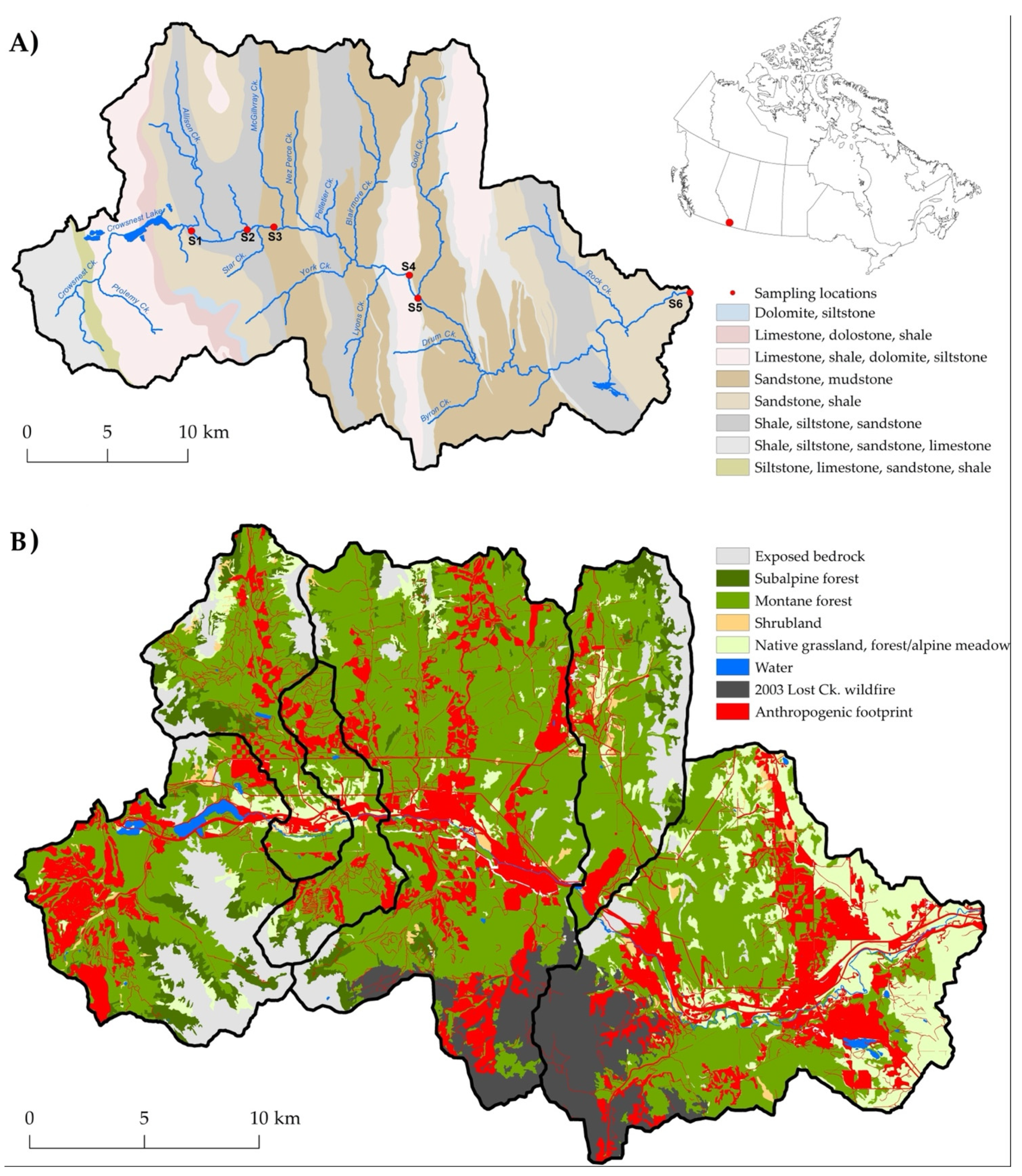
2.1. Study Area: Hydro-Climatic Setting

The Crowsnest River drains an area of 679 km2 on the eastern slopes of the Canadian Rocky Mountains in southwestern Alberta (Figure 1A). The headwaters of this gravel-bed river originate in upper montane snowmelt-dominated regions and drain into Crowsnest Lake (1357 m.a.s.l.). The river flows from the lake outflow eastward through the municipality of Crowsnest Pass before entering the Oldman Reservoir (1113 m.a.s.l.), nearly perpendicular to a series of geologic formations [36] comprised of sedimentary lithological complexes of dolomite, limestone, sandstone, siltstone, shale, and mudstones of marine origin (Figure 1A). A complex array of pre-glacial, glacial, and recent alluvial deposits consisting of thin colluvium, till blankets, and till veneers overlay these geologic formations [37]. Soils in the watershed are classified as imperfectly drained Brunisols and Regosols with weak horizon development [35]. Monthly precipitation from July to September ranges from approximately 40 to 65 mm, and the average daily temperature ranges from 9.5 and 14.3 °C [38].
Crowsnest Lake receives substantial groundwater inputs from sub-lacustrine springs and Crowsnest Creek that drain the upper reaches of the watershed [39]. Discharge in the uppermost reaches of the Crowsnest River originates as outflow from Crowsnest Lake and discharge in reaches of the Crowsnest River downstream is augmented by numerous tributary inflows that also receive substantial groundwater inputs [39,40,41]. The headwater reaches of the Crowsnest River below Crowsnest Lake are oligotrophic (mean TP = 15 µgL−1 n = 169 from 2012 to 2021: U. Silins, unpublished data).

2.2. Study Region: Land Disturbance

Anthropogenic landscape disturbance in the Crowsnest River watershed reflects over a century of regional settlement and natural resource extraction (mining, forestry). Six small communities (Crowsnest, Coleman, Blairmore, Frank, Bellevue, and Hillcrest) situated in the lower central valley span the study region from west to east. The Municipality of Crowsnest Pass (population ~5500) currently supports a diverse economy of tourism, natural resource-based industries, transportation (railway), and service sectors.
Digital vegetation and disturbance history datasets were used to generate a spatial dataset of land cover and cumulative disturbances in the Crowsnest River watershed. The data include sub-drainages corresponding to the six sampling locations used in this study (Figure 1B). The land cover data was developed using broad, aggregated vegetation (forest, shrubland, grassland/meadow) and land cover (exposed bedrock, open water) classes [42,43]. A summary of natural and anthropogenic land disturbances originating from the two data sources provides a description of the spatial distribution of disturbances pressures in the study area associated with the potential for erosion and non-point source delivery of sediment and associated metal oxides and P to streams. Land cover inventories for burned and partially burned vegetation units describe the natural disturbance from the 2003 Lost Creek wildfire [44]. Land disturbance classes developed from anthropogenic land disturbances (1950–2016) detail disturbance inventories for multiple land development sectors [45]. Disturbance classes were aggregated for agricultural (rough- and tame-pasture, cultivated lands), industrial (mining [coal, aggregate], forestry [conventional, salvage harvest from the 2003 wildfire], petrochemical, railways, electrical transmission corridors, other industrial lands), municipal (residential, light industrial, recreational [golf courses, ski hills, others], other municipal cleared lands) sectors, and regional roadways (paved, unpaved, unimproved roadways and trails, and cleared rights-of-way [ROW]). Land cover and aggregated natural and total (combined) anthropogenic disturbance footprints in the Crowsnest watershed are shown in Figure 1B.
The results of the land cover and landscape disturbance (natural and anthropogenic) analysis indicate that while considerable historic and current land disturbance pressures are evident across the entire watershed, combined natural and anthropogenic disturbance is notably greater in the lower reaches of the river (S4–S6) compared to the upper sub-watersheds (Table 1, Figure 1B). Combined natural and anthropogenic land disturbance ranged from 8–34% across each of the six study sub-watersheds where the total combined disturbance footprint for the Crowsnest basin was 25% in 2016. Industrial development represents the greatest proportional disturbance footprint in the upper portion of the watershed (S1–S3/S4), while the combined disturbances from the 2003 wildfire, industrial, municipal, and agriculture sectors comprised the generally greater disturbance footprint evident in the lower half of the watershed (S4–S6, Table 1). While natural disturbance from the 2003 Lost Creek wildfire included 4465 ha in sub-watersheds S4–S6, 67% of the total disturbance footprint in S4–S6 is anthropogenic. Multiple storm sewer outfalls discharge runoff and particulate matter into the Crowsnest River at sites S4, S5, and S6. A regional wastewater treatment facility discharges effluent to the Crowsnest River after primary and some limited secondary wastewater treatment above S5.

2.3. Sample Collection

A sediment sample collection program was designed to evaluate changes in PP fractions in the Crowsnest Riverbed sediments resulting from four tributary inflows and a municipal wastewater treatment plant (which consisted only of primary treatment by sedimentation at the time of the investigation) that reflect increasing landscape disturbance pressures in the watershed (Figure 1A; Table 1). Composite samples of surficial fine interstitial sediment (0–5 cm) were collected across a reach at each study site during low flows (late July–August in 2016 and 2017) [48]. The total number of composite samples includes four from August 2016 (collected approximately one week apart), one from July 2017, and two from August 2017. Composite sediment samples were later sieved and materials <250 μm were retained for geochemical analysis (resulting in n = 7 per site). For PP fractions, the four 2016 samples were combined and homogenized, while the composite samples were analyzed for PP and geochemistry.

2.4. Laboratory Analyses

Interstitial sediment (<250 µm) was analyzed using standard methods [49]. Absolute particle size distributions, median diameter (D50), and specific surface area (SSA) were measured with a Malvern Mastersizer 2000 after sample pre-treatment with hydrogen peroxide to remove organic material and chemical and ultrasonic dispersion. Major element composition (SiO2, Al2O3, Fe2O3, MnO, CaO, MgO, Na2O, K2O, TiO2, P2O5, V2O5) was determined by X-ray fluorescence. Loss on ignition (LOI) was determined by combusting ~2 g of sediment at 450 °C for four hours. The results were reported as percent dry weight [50]. Analytical accuracy was confirmed by analyzing Canadian Reference Standards AGV-1, MRG-1, NCM-N, GSP-1, and SY-3.
A sequential extraction scheme was used to fractionate PP into five operationally-defined, reactive phosphorus (RP) fractions [15,18]. These were: (1) NH4Cl-RP (1.0 M NH4Cl-P extractable P) or loosely sorbed P; (2) BD-RP (0.11 M NaHCO3·Na2S2O4 extractable P) or reductant soluble P; (3) NaOH-RP (1.0 M NaOH extractable P) or reactive P sorbed to metal oxides [51]; (4) HCl-RP, or apatite P, is the 0.5 M HCl extractable P fraction bound phosphate minerals [52]; (5) the refractory P fraction, or organic P, defined as the hot 1.0 M NaOH (85 °C) extractable fraction. All fractions supernatants were measured using colourimetry for molybdenum reactive P. Bioavailable PP is the sum of fractions 1 to 3, in these fractions phosphate desorbs under favorable environmental conditions to surrounding waters [19] and is more readily available for biotic uptake [12,20]. Total PP (TPP) is the sum of all five fractions.

2.5. Statistical Analyses

The distribution of PP forms in riverbed sediment was evaluated at two spatial scales: between individual sites (i.e., inter-site) and the larger macro-scale. In the macro-scale analysis, study sites were grouped into upstream (S2–3, n = 8) and downstream sites (S4–6, n = 12) based on anthropogenic and natural land disturbance footprint data presented in Table 1. While roads, cleared lands, municipal, and industrial footprints were dominant at upstream sites (S2–3), the additional disturbance pressures from wastewater effluent, agriculture, and wildfire at the downstream site (S4–6) were notable (Table 1). Data from the most upstream site (S1) were not included in this comparison because of the unexpected presence of Didymosphenia geminata algal mats during the latter part of the study period.
Inter-site differences in PP forms stored in the riverbeds were evaluated using Kruskal-Wallis and post hoc pairwise Mann-Whitney rank-sum tests with a Benjamini-Hochberg (BH) false discovery rate correction for multiple comparisons (n = 4 per site). Macro-scale differences in PP forms stored in the riverbed were evaluated by comparing upstream (S2, S3; n = 8) and downstream (S4, S5; n = 12) concentrations of PP fractions using the Wilcoxon signed-rank test.
Non-parametric Kendall’s tau correlation coefficients (n = 24) were used to evaluate the relationships between PP fractions, major element composition and absolute particle size (D10, D50, D90, SSA). Particle size and major element compositions were compared across sites (n = 7 per site) using Kruskal-Wallis and post hoc pairwise Mann-Whitney rank-sum tests using the BH false-discovery rate p-value adjustment.
Linear discriminant analysis (LDA) was used to examine spatial differences in the major element composition of interstitial sediment across sites. Due to the relatively small sample size, variables were tested for normality through visual inspection of quantile-quantile plots and only variables that satisfied normality were then tested for multicollinearity (Al2O3, Fe2O3, MnO, CaO, K2O, TiO2, V2O5). To satisfy normality, a logit function was used to transform CaO and a variance inflation factor (VIF,   1 / ( 1 R 2 )) was used to determine variables sufficiently distinct to avoid multicollinearity. The choice of a VIF threshold is ambiguous [53]. However, it has been argued that multicollinearity is only severe if VIF is >10 [54]. Variables that were deemed sufficiently distinct (i.e., with VIFs < 5 [Al2O3, MnO, CaO]), were used in the LDA. A confusion matrix for the LDA was calculated by removing a data point from each site and calculating the probability of correct classification (not shown as all were classified correctly). All computations, analyses and figures were generated in R version 4.0.3.

3. Results

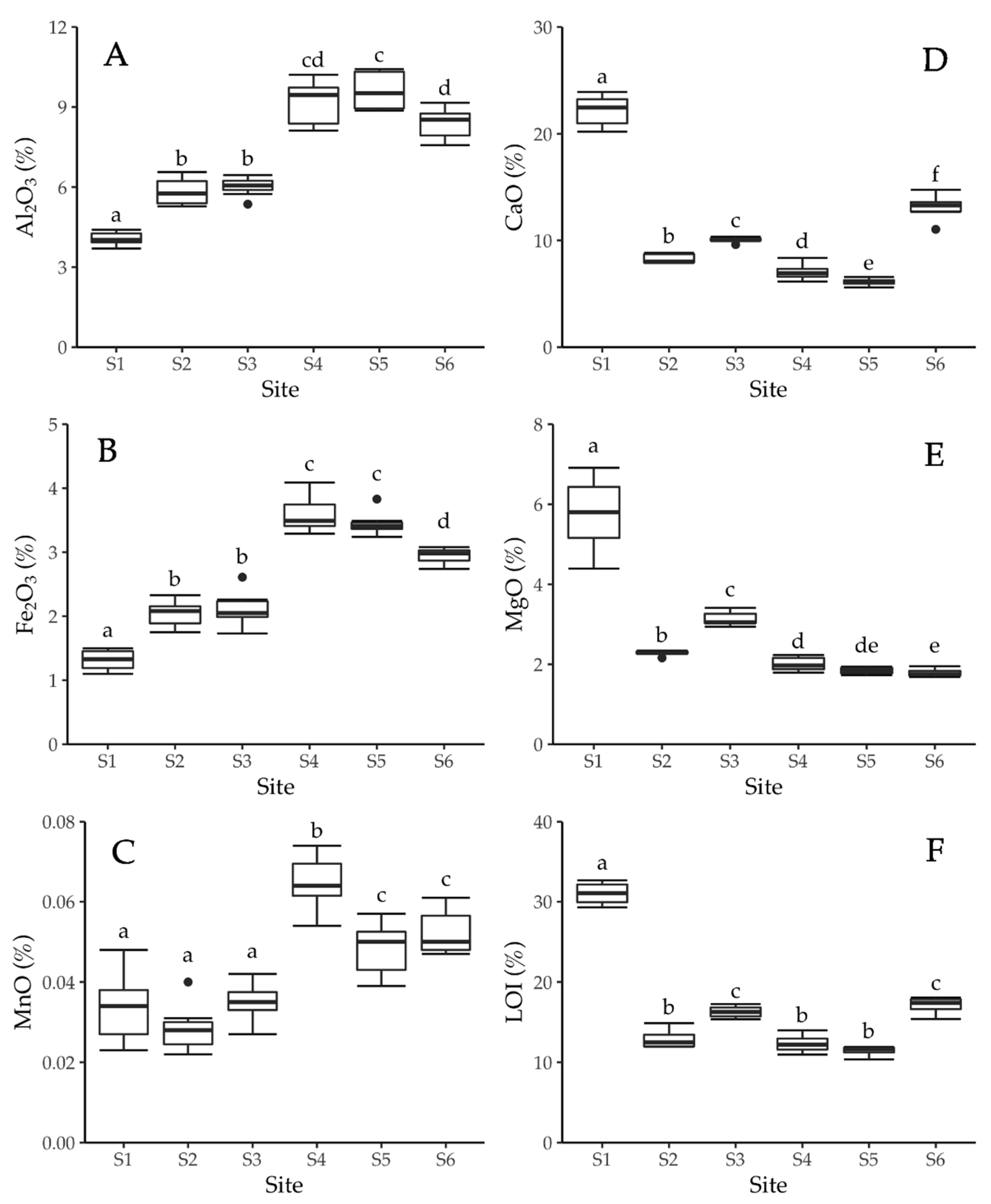
3.1. Sediment Characteristics

Fine sediment comprised 2 to 8% of the total sediment mass in the gravel-bed matrix of the Crowsnest River. The D50 and the SSA of the fine sediment ranged from 41 to 70 µm and 0.44 to 0.63 g−1m2, respectively. The D50 and SSA were not significantly different among sites (p = 0.522 and 0.438, respectively).

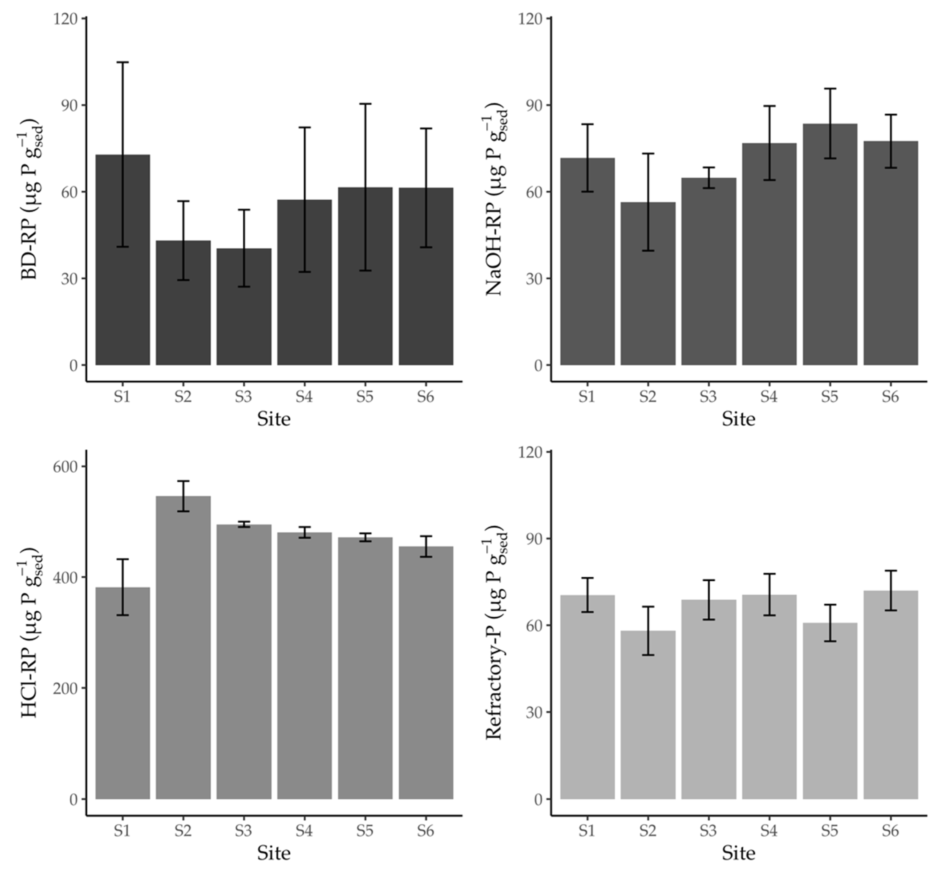
3.2. Total and Fractional Composition of Particulate Phosphorus

Concentrations of TPP stored in the gravel-bed matrix of the Crowsnest River ranged from 469.9 to 734.1 µg g−1. Mean TPP concentrations across the study sites ranged from 601.7 µg g−1 at S1 to 708.6 µg g−1 at S2. TPP concentrations were significantly different between sites (p = 0.029). Of the three bioavailable PP forms (i.e., fractions 1 to 3), concentrations of NH4Cl-RP (i.e., fraction 1) were below the detection limit (10 µg g−1) and therefore not reported herein. Notably, with the exception of S1, the average observed concentration of the remaining bioavailable PP forms (i.e., BD-RP and NaOH-RP; fractions 2 and 3, respectively) slightly increased from upstream sites (S2–S3) to downstream sites (S4–S6) (Figure 2); however, these differences (expressed as either individual fractions or cumulatively as NAIP) were not statistically significant between sample sites. HCl-RP (i.e., apatite p; fraction 4) was the largest proportion and typically accounted for >60% of TPP for all study sites (Figure S1). Concentrations of HCl-RP at S1 were significantly different from those observed at all other study sites (p = 0.04 for all sites). The concentrations of HCl-RP forms at S2 were also significantly different from those observed at all other study sites (p = 0.04 for all sites). Concentrations of refractory-P were not significant between the study sites.

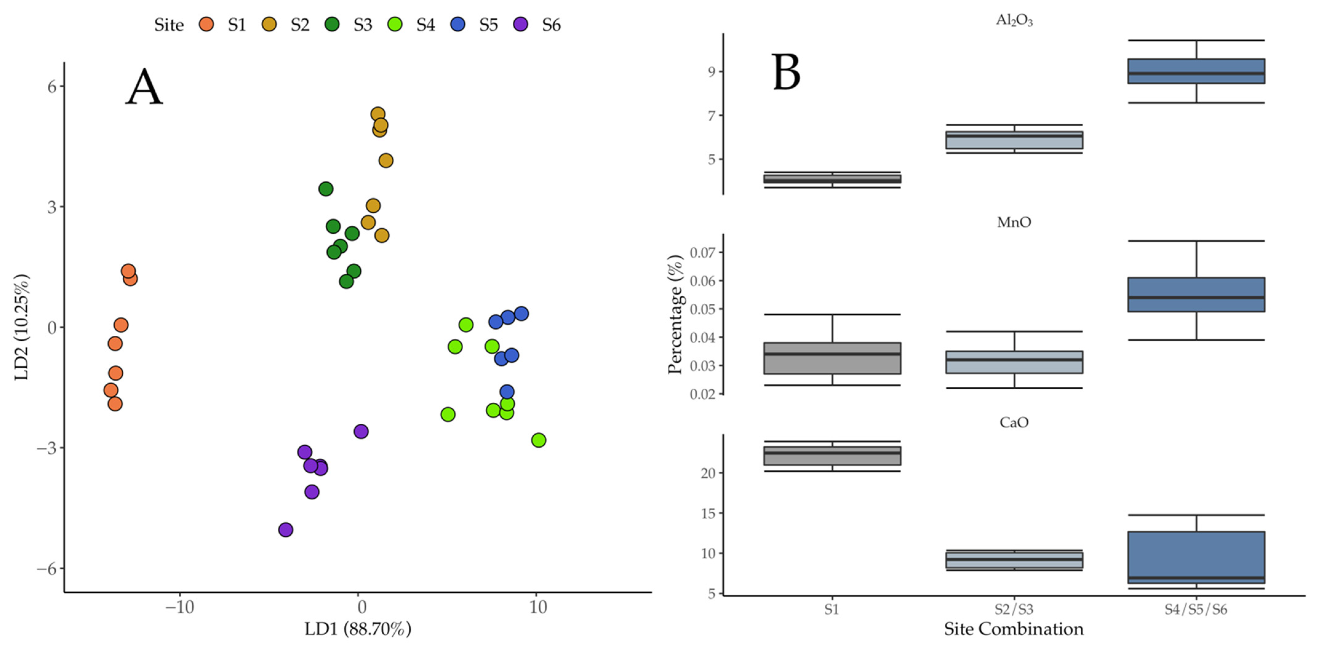
3.3. Sediment Geochemistry and Relationship to Particulate P Forms

Major element composition of fine sediment in the riverbed was notably consistent over the two-year study period (Figure 3). As shown in Figure 3A–C, the upper reaches of the river (S1–S3) had lower concentrations of Fe2O3, Al2O3, and MnO compared to downstream sites (S4–S6)—these differences were statistically significant (p values for all of the comparisons of metal oxide concentrations at the various sites are provided in Tables S1–S3). Another key observation is that S1, located immediately below the outflow of the groundwater-fed Crowsnest Lake, had the highest concentrations of CaO and MgO, and LOI (Figure 3D–F). While differences in the concentrations of some of these major elements between sites S2 to S6 were statistically significant, these concentrations were substantially more similar and much lower than those observed at S1.
Spatial differences in the major element composition of interstitial sediment across sites were examined with LDA. The first two functions from the LDA show that Al2O3, MnO, and CaO accounted for 98.95% of their variance (Table 2, Figure 4A), with differences in CaO primarily driving site separation (Figure 3 and Figure 4). However, some sites were not as readily differentiated by LDA, such as S2 and S3; and S4 and S5. Further, CaO was the key driver in separating S4 and S5 from S6 in the LDA, as comparable metal oxides were observed in between S4 to S6 (Figure 3 and Figure 4B).
Biologically available fractions of PP were positively correlated with metal-oxides (Al2O3 and MnO). The difference in MgO was significant; it was higher for upstream sites (S1 to S3, p < 0.05) and negatively correlated with NaOH-RP (p < 0.05). HCl-RP and refractory-P fractions were only correlated, positively and negatively, respectively, with SiO2 (Table 3).

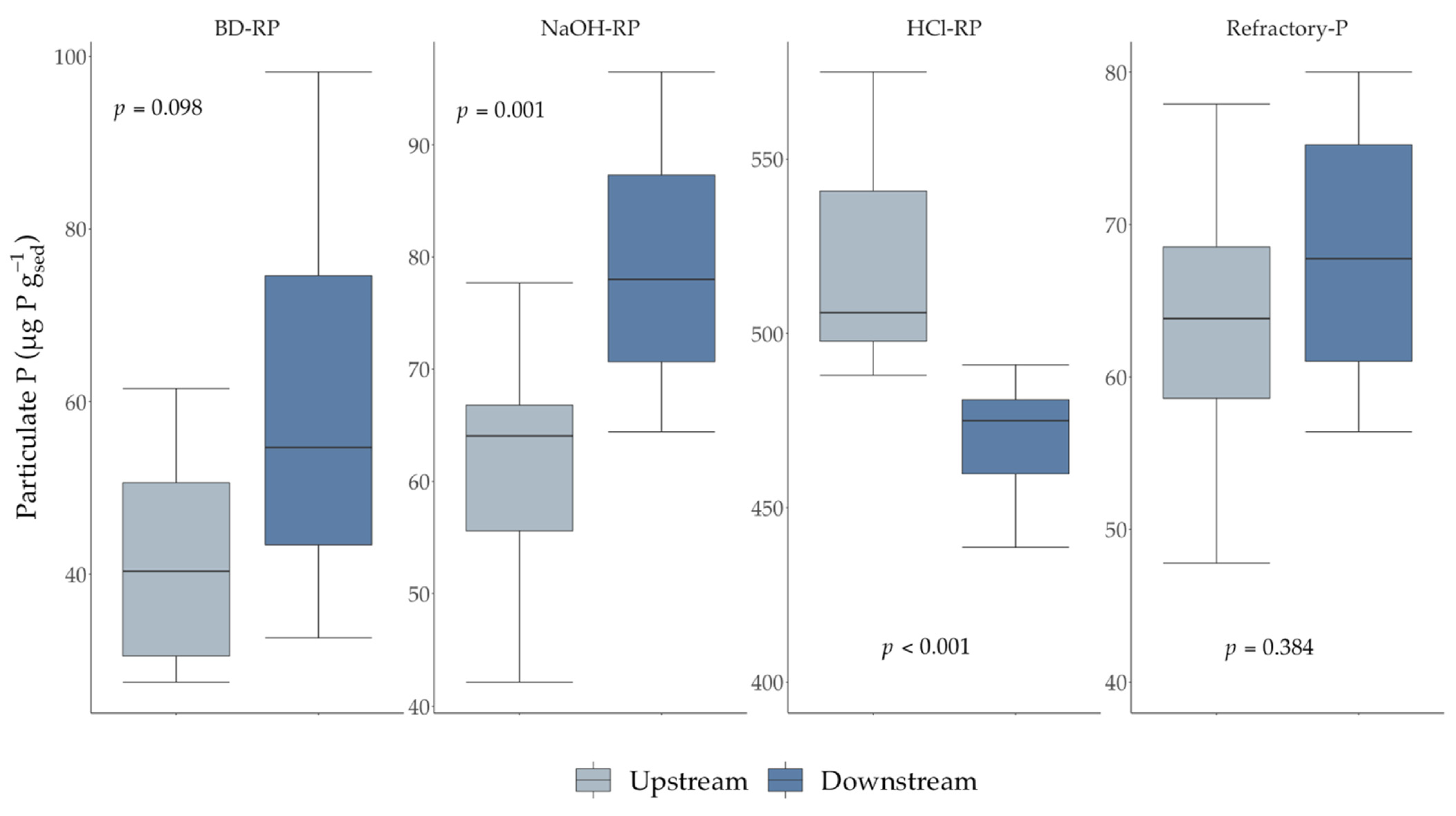
3.4. Downstream Changes in Particulate P

To examine the potential cumulative effects of increasing landscape disturbance on PP form in the Crowsnest River, the study sites were categorized as “upstream” and “downstream” according to longitudinal changes in sediment geochemistry (Figure 3) and increasing landscape pressures (Table 1). Upstream sites (S2–S3) have impacts primarily from industrial, municipal, land clearing, and linear (road) pressures while downstream sites (S4–S6) have additional landscape disturbance pressures from agriculture, municipal pressures, wastewater effluent, and wildfire. TPP concentrations between upstream (S2, S3) and downstream (S4–S6) sites were not statistically significant. However, PP forms between upstream and downstream sites were significant (Figure 5). Notably, differences in the bioavailable fractions (NaOH-RP and BD-RP) were significant; both were higher at downstream sites (p = 0.098 and <0.01, respectively), whereas the HCl-RP fraction was higher at the upstream sites (p < 0.01).

4. Discussion

4.1. Particulate P Fractions, Landscape Disturbance and Geochemical Controls

Phosphorus is a critical nutrient that limits productivity in many temperate freshwater aquatic environments [55]. It is widely acknowledged that increased contributions of P from anthropogenic sources (i.e., agricultural, industrial, and municipal wastewater) have resulted in the eutrophication of freshwater environments globally [56]. Although their cause is not well understood, recent widespread, continental-scale increases in TP that have been observed in oligotrophic rivers draining relatively underdeveloped forest environments are alarming because of the associated potential for extensive ecosystem consequences, including increased incidence of algal blooms, altered aquatic habitats [24], and concerns for the provision of safe drinking water [6,7]. One possible explanation for these observations is increased atmospheric deposition of P originating from a variety of sources such as the erosion of soils by wind, emissions from forest fires, and combustion of fossil fuels [57,58,59]. While recent evidence suggests that increased lotic TP concentrations can result from atmospheric deposition [60,61,62], the extent to which increases in either dry or wet deposition of TP in forested environments will lead to elevated stream TP concentrations is unknown. Climate change-driven extremes in precipitation and high magnitude runoff events can also substantially increase delivery of PP to receiving streams [24]; these impacts can be significantly compounded when these events occur on wildfire-impacted landscapes [6]. In such cases, the delivery of fine sediment to high-quality streams in forested regions has the potential to serve as an internal source of nutrients to the water column through the release of P from sediment during environmentally sensitive conditions of low flow [8,12].
Anthropogenic and climate change-exacerbated landscape disturbance pressures have likely influenced the source and export of sediment-associated P in the Crowsnest River watershed. Previous studies in this watershed have demonstrated that wildfire can: (1) alter the form and mobility of sediment-associated P in aquatic systems, and; (2) produce large basin-scale P export legacy effects that persist for decades [5,6,7,35]. Critically, previously reported estimates of suspended sediment TPP concentrations in the Crowsnest River did not include PP forms stored in the riverbed. Although the increase in average TPP concentrations at the downstream locations was not statistically significant, a more detailed comparison between the upstream (S2–S3) and downstream (S4–S6) study sites nonetheless demonstrated significant differences in both bioavailable PP fractions (BD-RP and NaOH-RP) present. Despite the microscale variability observed in PP, there was a significant downstream increase in the bioavailable PP form (NaOH-RP) observed at the lower sites (S4–S6) that is related to the cumulative impacts of tributary inflows that are impacted by wildfire (S4), municipal wastewater discharges (S5), and agricultural runoff (S6). Accordingly, the present investigation demonstrates the longitudinal impacts of increasing landscape disturbance pressures on riverbed bioavailable PP forms and illustrates how the convergence of anthropogenic (i.e., municipal wastewater discharges, roads, agriculture, stormwater) and climate-exacerbated (wildfire) landscape disturbances converge to alter P bioavailability by producing riverbed sediment legacies that will likely increase eutrophication potential in oligotrophic river systems.
In absence of intensive analytical investment and cost, the cumulative effects of multiple disturbance pressures in a watershed often preclude confirmation of specific individual or composite landscape disturbance effects on longitudinal changes in the geochemical composition of bed sediment. Despite such limitations, the Crowsnest River sediment geochemical data suggest that the effects of the 2003 Lost Creek wildfire are still evident in the gravel-bed matrix 12- and 13-years post-fire. Wildfire effects on soil and sediment chemistry can vary considerably due to factors such as vegetation type, landscape conditions (e.g., soil moisture), and wildfire characteristics (e.g., severity) [63]. Wildfire ash can include a range of elements (e.g., Ca, Mg, K, Si, P, Na, and S) and metals (e.g., Al, Fe, Mn, and Zn) [64,65,66]. The relative proportion of these materials in ash will either increase or decrease depending on the temperature of combustion and degree of volatilization [67]. Because Mn volatilizes at temperatures exceeding ~1962 °C, it typically remains in ash; it can complex with organic matter at temperatures >400 °C [68]. Notably elevated concentrations of Mn have previously been reported in soils, post-fire runoff, and stream sediment [63,68,69,70,71,72]. In the present study, Mn concentrations in fine bed sediment below the outflow of the wildfire-impacted Lyons Creek (S4) were significantly higher than at any of the other sites and remained significantly elevated at downstream sites, relative to those upstream (Figure 3C). Moreover, the bioavailable P fractions (NaOH-RP and BD-RP) were correlated with Mn (Table 3), as would be expected because of the known preferential adsorption of bioavailable P forms on sediment surfaces containing metal (including Mn) oxyhydroxides [16]. This observation is further consistent with elevated levels of bioavailable PP in sediments suspended in the Crowsnest River, which persisted for at least seven years after the Lost Creek wildfire [6]. Here, we suggest that the primary source of elevated Mn levels at S4 is sediment and pyrogenic materials mobilized in the Lyons Creek watershed and subsequently transported to the Crowsnest River. To our knowledge, this is the first study to demonstrate the legacy effect of wildfire-associated increases in bioavailable PP forms (BD-RP and NaOH-RP) in riverbed sediments—they persisted for over a decade after wildfire and have been shown to serve as an internal source of bioavailable P that promotes downstream primary productivity [8] and potential eutrophication risk in aquatic environments. Bed sediments play an especially critical role in regulating nutrient dynamics in sediment-rich rivers such as the Crowsnest [7,35] where wildfire-induced biostabilization increases the shear stress that must be overcome to mobilize fine sediment, but also results in substantial increases in erosion depth, thereby releasing more suspended sediment and associated P to the water column at higher flow conditions [73].
Despite the effects of multiple landscape disturbance pressures on sediment erosion and delivery to streams within each contributing sub-watershed of the Crowsnest River, downstream patterns of major element composition remained remarkably consistent over the two-year study period (Figure 3). The study commenced with a hypothesis that PP levels would progressively increase downstream with increasing cumulative effects from landscape disturbances. While the investigation generally supports this hypothesis for bioavailable PP, this conclusion first required consideration of the unexpected biological activity at the upstream study site (S1). The occurrence of a Didymosphenia geminata, a freshwater diatom that can form thick mats and alter benthic habitat and community structure [74,75,76], at S1 was a critical consideration that could have been easily overlooked in absence of detailed site/disturbance characterization. D. geminata is typically associated with oligotrophic stable environments, often lake or dam fed, where conditions include high pH and low P concentrations [74,75,76]—similar to S1, a stable lake-fed, high pH and low P oligotrophic environment [77]. These diatoms can efficiently modify their hydrodynamic environment increasing the friction at the D. geminata surface and increasing turbulence above the mats [78]; this could lead to deposition of sediments onto the mats and increasing water column-mat solute exchange. There is still debate about the role of D. geminata’s effect on nutrient availability and there are various factors that likely confounded the analysis of PP forms because of the impossibility of separating sediment and D. geminata mat solids prior to analysis. In the specific case of our study, high concentrations of the bioavailable forms of PP at the most upstream site occurred where there is difficulty separating not only the physical sediment and diatoms but the microscale and mesoscale biofilm effects from macroscale landscape impacts.

4.2. Implications for Nutrient Storage and Drinking Water Source Protection

Landscape disturbance effects on the source and transport of PP fractions in rivers have been widely reported [15,28,79]. However, disentangling environmental changes affected by cumulative watershed impacts and their influence on processes driving the generation and transport of water and sediment is extremely difficult due to the heterogeneous nature of landscapes, hydro-climatic variability, and the convergence of natural and anthropogenic disturbance impacts that occur at a range of spatial and temporal scales. Knowledge of the downstream variability and distribution of PP forms in riverbed sediment and its relationship to water quality is necessary from a management perspective, particularly when the levels and bioavailability of PP represent a potential risk to drinking water treatability and public health by promoting the proliferation of cyanobacteria that may produce toxins of health concern or unpleasant tastes and odors, and challenge drinking water treatment processes in downstream environments such as lakes and reservoirs [6,7,11,12].
Despite the substantial challenge of elucidating sediment sources due to cumulative watershed impacts, the present study provides critical information regarding the relative amount and spatial variability of bioavailable PP forms present in the Crowsnest River and documents downstream changes in PP resulting from natural and anthropogenic landscape disturbance in this critical forested source water region of Alberta, Canada. In particular, the present study points to the need to develop and implement more strategic sampling programs to characterize source contributions and downstream variability in sediment chemistry and its relationship to surface water quality because single-point sampling can either over or underestimate threats to water quality depending upon when and where samples are collected. This two-year study highlights the considerable spatial (6–55%) and temporal (4–37%) variability in TPP in the Crowsnest River. The bioavailable forms varied temporally (within sites) between 13 and 265% and spatially (between sites) between 40 and 180%. This variability is due to heterogeneity in river substrate and morphology, the differential effects of multiple landscape disturbance types on the nature of sediments from tributary inflows and the presence of freshwater diatom (D. geminata) mats that trap fine sediment. Compared to upstream sites (S2–S3, legacy and recent harvesting), bioavailable PP concentrations increased downstream at sites that received tributary inflows from burned watersheds (S4, S6) and sewage effluent (S5 and S6) highlighting the role land-use can play in creating “hotspots” for nutrient release in rivers [80].
Interstitial fine sediment in gravel-bed rivers represents a significant, long-term source of bioavailable P, but the process of fine sediment entrapment and its influence on P mobility requires further investigation [81]. The degree to which nutrient hotspots are related to the entrapment of fine sediment from variable sediment sources and its long-term implications for downstream water quality represents a key challenge for watershed managers. A major challenge associated with cumulative effects assessment is properly distinguishing the relative contribution and short and long-term effects of sediment originating from multiple disturbance types and sediment source areas. Geochemical tracing approaches have begun to show promise as an important tool for watershed management. While post-wildfire land disturbance effects on downstream transport of suspended fine sediment were identified at a large basin scale six to seven years after a wildfire using a fingerprinting approach [82], the methodology applied, choice of tracers employed and the physico-chemical basis for source discrimination require careful consideration and further refinement [83].

5. Conclusions

Continental-scale increases in TP that have been recently observed in oligotrophic rivers draining relatively underdeveloped forest environments are alarming because of the associated potential for extensive ecosystem consequences, including increased incidence of algal blooms, altered aquatic habitats, and concerns for the provision of safe drinking water. The present investigation demonstrated that anthropogenic (i.e., harvesting, and municipal wastewater discharges) and climate-exacerbated (e.g., wildfires) landscape disturbances are likely converging to alter P bioavailability in an oligotrophic river already. Our study points to the need for more detailed field investigations both to corroborate our findings elsewhere, but more importantly, to confirm the impacts of individual or composite drivers of P in terms of cause and effect. Specifically, bioavailable PP stored in gravel riverbeds at small but increasing downstream concentrations represents a critical in-channel source of nutrient delivery to the water column and a potentially significant threat to downstream water quality and drinking water treatability. Atmospheric deposition, extremes in precipitation, and high magnitude runoff events are amongst the most plausible causes of increasing TP in oligotrophic rivers, but additional research is clearly warranted. Climate change-exacerbated drivers of the initial delivery of P to receiving waters—as seen in the present investigation—underscored that the longevity and cascading ecological impacts of these increases, which must also be better understood, especially for the preservation or remediation of oligotrophic and mesotrophic systems. This requires consideration of the potential for: (1) in-channel storage of fine sediment, and (2) ongoing delivery of bioavailable P to the water column from that sediment, especially in systems that are rich in fine-grained surficial/interstitial deposits and where gravel-bed rivers predominate. Future work should also consider the role of biofilms in trapping and transforming P and other nutrients in gravel-bed rivers and scaling those processes to larger basin scales.

Supplementary Materials

The following are available online at https://www.mdpi.com/article/10.3390/w13223151/s1, Figure S1: Average proportion of particulate phosphorus (PP) forms in fine sediments stored in the gravel-bed of the Crowsnest River in 2016 and 2017 (n = 4 per site), Table S1: p-values for post-hoc pairwise Mann-Whitney rank sum tests between sites for riverbed fine sediment Al2O3 proportions, Table S2: p-values for post-hoc pairwise Mann-Whitney rank sum tests between sites for riverbed fine sediment Fe2O3 proportions, Table S3: p-values for post-hoc pairwise Mann-Whitney rank sum tests between sites for riverbed fine sediment MnO proportions.

Author Contributions

Conceptualization, M.S. and C.W.; methodology, M.S. and C.W.; formal analysis, C.W., M.S. and U.S.; writing—original draft preparation, C.W. and M.S.; writing—review and editing, M.B.E., M.S., A.L.C. and U.S.; writing—final draft preparation, C.W., M.B.E. and M.S.; visualization, C.W.; supervision, M.S.; project administration, M.S.; funding acquisition, M.S., M.B.E., U.S. and A.L.C. All authors have read and agreed to the published version of the manuscript.

Funding

Fieldwork and lab analyses were funded by NSERC Discovery Grant 481 RGPIN-2020-06963 awarded to M.S.; Alberta Innovates Energy and Environment Solutions Grant AI-EES:2096 awarded to U.S., M.B.E., and M.S.; and Alberta Innovates BIO Grant AI-BIO: Bio-13-009 awarded to U.S., M.B.E, and M.S. The support of the forWater NSERC Network for Forested Drinking Water Source Protection Technologies [NETGP-494312-16] is also acknowledged. The contribution of A.L.C. was funded by the UKRI-BBSRC (UK Research and Innovation-Biotechnology and Biological Sciences Council) institute strategic programme grant BBS/E/C/000I0330.

Institutional Review Board Statement

Not applicable.

Informed Consent Statement

Not applicable.

Data Availability Statement

Contact corresponding author for data availability.

Acknowledgments

Thank you to the crew of the Southern Rockies Watershed Project, specifically, Amber Becker, Quinn Decent, Kalli Herlein, Amanda Martens, Chrystyn Skinner, Sheena Spencer, and Chris Williams.

Conflicts of Interest

The authors declare no conflict of interest. The funders had no role in the design of the study; in the collection, analyses, or interpretation of data; in the writing of the manuscript, or in the decision to publish the results.

References

  1. Westerling, A.L.; Hidalgo, H.G.; Cayan, D.R.; Swetnam, T.W. Warming and Earlier Spring Increase Western U.S. Forest Wildfire Activity. Science 2006, 313, 940–943. [Google Scholar] [CrossRef] [PubMed] [Green Version]
  2. Wagenbrenner, J.; Robichaud, P.; Brown, R. Rill erosion in burned and salvage logged western montane forests: Effects of logging equipment type, traffic level, and slash treatment. J. Hydrol. 2016, 541, 889–901. [Google Scholar] [CrossRef]
  3. Sharpley, A.; Jarvie, H.; Buda, A.; May, L.; Spears, B.; Kleinman, P. Phosphorus Legacy: Overcoming the Effects of Past Management Practices to Mitigate Future Water Quality Impairment. J. Environ. Qual. 2013, 42, 1308–1326. [Google Scholar] [CrossRef] [Green Version]
  4. Jankowiak, J.; Hattenrath-Lehmann, T.; Kramer, B.J.; Ladds, M.; Gobler, C.J. Deciphering the effects of nitrogen, phosphorus, and temperature on cyanobacterial bloom intensification, diversity, and toxicity in western Lake Erie. Limnol. Oceanogr. 2018, 64, 1347–1370. [Google Scholar] [CrossRef] [Green Version]
  5. Sena, M.; Morris, M.R.; Seib, M.; Hicks, A. An exploration of economic valuation of phosphorus in the environment and its implications in decision making for resource recovery. Water Res. 2020, 172, 115449. [Google Scholar] [CrossRef]
  6. Emelko, M.B.; Stone, M.; Silins, U.; Allin, D.; Collins, A.L.; Williams, C.H.; Martens, A.M.; Bladon, K.D. Sediment-phosphorus dynamics can shift aquatic ecology and cause downstream legacy effects after wildfire in large river systems. Glob. Chang. Biol. 2016, 22, 1168–1184. [Google Scholar] [CrossRef] [PubMed]
  7. Emelko, M.B.; Silins, U.; Bladon, K.; Stone, M. Implications of land disturbance on drinking water treatability in a changing climate: Demonstrating the need for “source water supply and protection” strategies. Water Res. 2011, 45, 461–472. [Google Scholar] [CrossRef] [PubMed]
  8. Silins, U.; Bladon, K.D.; Kelly, E.N.; Esch, E.; Spence, J.R.; Stone, M.; Emelko, M.B.; Boon, S.; Wagner, M.J.; Williams, C.H. Five-year legacy of wildfire and salvage logging impacts on nutrient runoff and aquatic plant, invertebrate, and fish productivity. Ecohydrology 2014, 7, 1508–1523. [Google Scholar] [CrossRef]
  9. McDowell, R.; Sharpley, A. The effect of antecedent moisture conditions on sediment and phosphorus loss during overland flow: Mahantango Creek catchment, Pennsylvania, USA. Hydrol. Process. 2002, 16, 3037–3050. [Google Scholar] [CrossRef]
  10. Stutter, M.; Lumsdon, D. Interactions of land use and dynamic river conditions on sorption equilibria between benthic sediments and river soluble reactive phosphorus concentrations. Water Res. 2008, 42, 4249–4260. [Google Scholar] [CrossRef]
  11. House, W.A.; Warwick, M.S. Interactions of phosphorus with sediments in the River Swale, Yorkshire, UK. Hydrol. Process. 1999, 13, 1103–1115. [Google Scholar] [CrossRef]
  12. Jarvie, H.P.; Jürgens, M.D.; Williams, R.J.; Neal, C.; Davies, J.J.; Barrett, C.; White, J. Role of river bed sediments as sources and sinks of phosphorus across two major eutrophic UK river basins: The Hampshire Avon and Herefordshire Wye. J. Hydrol. 2005, 304, 51–74. [Google Scholar] [CrossRef]
  13. Mulholland, P.J.; Marzolf, E.R.; Webster, J.R.; Hart, D.R.; Hendricks, S.P. Evidence that hyporheic zones increase heterotrophic metabolism and phosphorus uptake in forest streams. Limnol. Oceanogr. 1997, 42, 443–451. [Google Scholar] [CrossRef]
  14. Boulton, A.J.; Datry, T.; Kasahara, T.; Mutz, M.; Stanford, J.A. Ecology and management of the hyporheic zone: Stream-groundwater interactions of running waters and their floodplains. J. N. Am. Benthol. Soc. 2010, 29, 26–40. [Google Scholar] [CrossRef] [Green Version]
  15. Stone, M.; English, M. Geochemical composition, phosphorus speciation and mass transport of fine-grained sediment in two Lake Erie tributaries. In Proceedings of the Third International Workshop on Phosphorus in Sediments, Zeist, The Netherlands, 30 September–3 October 1993; pp. 17–29. [Google Scholar]
  16. Golterman, H.L. The Chemistry of Phosphate and Nitrogen Compounds in Sediments; Springer Science & Business Media: Berlin/Heidelberg, Germany, 2004. [Google Scholar]
  17. Weigelhofer, G.; Hein, T.; Bondar-Kunze, E. Phosphorus and nitrogen dynamics in riverine systems: Human impacts and management options. In Riverine Ecosystem Management; Schmutz, S., Sendzimir, J., Eds.; Springer Open: New York, NY, USA, 2018; Volume 187. [Google Scholar]
  18. Pettersson, K.; Boström, B.; Jacobsen, O.-S. Phosphorus in sediments—Speciation and analysis. In Phosphorus in Freshwater Ecosystems; Springer: New York, NY, USA, 1988; pp. 91–101. [Google Scholar]
  19. DePinto, J.V.; Young, T.C.; Martin, S.C. Algal-available phosphorus in suspended sediments from lower Great Lakes tributaries. J. Great Lakes Res. 1981, 7, 311–325. [Google Scholar] [CrossRef]
  20. House, W.A. Geochemical cycling of phosphorus in rivers. Appl. Geochem. 2003, 18, 739–748. [Google Scholar] [CrossRef]
  21. Prosser, I.P.; Rutherfurd, I.D.; Olley, J.M.; Young, W.J.; Wallbrink, P.J.; Moran, C.J. Large-scale patterns of erosion and sediment transport in river networks, with examples from Australia. Mar. Freshw. Res. 2001, 52, 81–99. [Google Scholar] [CrossRef]
  22. Kemp, P.; Sear, D.; Collins, A.; Naden, P.; Jones, I. The impacts of fine sediment on riverine fish. Hydrol. Processes 2011, 25, 1800–1821. [Google Scholar] [CrossRef]
  23. Owens, P.N.; Walling, D.E. The phosphorus content of fluvial sediment in rural and industrialized river basins. Water Res. 2002, 36, 685–701. [Google Scholar] [CrossRef]
  24. Stoddard, J.; Van Sickle, J.; Herlihy, A.; Brahney, J.; Paulsen, S.; Peck, D.V.; Mitchell, R.; Pollard, A.I. Continental-Scale Increase in Lake and Stream Phosphorus: Are Oligotrophic Systems Disappearing in the United States? Environ. Sci. Technol. 2016, 50, 3409–3415. [Google Scholar] [CrossRef] [Green Version]
  25. McDowell, R.; Sharpley, A.; Folmar, G. Phosphorus Export from an Agricultural Watershed: Linking Source and Transport Mechanisms. J. Environ. Qual. 2001, 30, 1587–1595. [Google Scholar] [CrossRef] [Green Version]
  26. Markovic, S.; Blukacz-Richards, A.E.; Dittrich, M. Speciation and bioavailability of particulate phosphorus in forested karst watersheds of southern Ontario during rain events. J. Great Lakes Res. 2020, 46, 824–838. [Google Scholar] [CrossRef]
  27. Pacini, N.; Gächter, R. Speciation of riverine particulate phosphorus during rain events. Biogeochemistry 1999, 47, 87–109. [Google Scholar] [CrossRef]
  28. Fogal, R.; Mulamoottil, G.; Stone, M.; Logan, L. Longitudinal and seasonal patterns of phosphorus in riverbed sediments. J. Environ. Plan. Manag. 1995, 38, 167–180. [Google Scholar] [CrossRef]
  29. Poulenard, J.; Dorioz, J.-M.; Elsass, F. Analytical electron-microscopy fractionation of fine and colloidal particulate-phosphorus in riverbed and suspended sediments. J. Aquat. Geochem. 2008, 14, 193–210. [Google Scholar] [CrossRef]
  30. Ballantine, D.; Walling, D.; Collins, A.; Leeks, G. The content and storage of phosphorus in fine-grained channel bed sediment in contrasting lowland agricultural catchments in the UK. Geoderma 2009, 151, 141–149. [Google Scholar] [CrossRef]
  31. Barral, M.; Devesa-Rey, R.; Ruiz, B.; Diaz-Fierros, F. Evaluation of phosphorus species in the bed sediments of an Atlantic Basin: Bioavailability and relation with surface active components of the sediment. Soil Sediment Contam. 2012, 21, 1–18. [Google Scholar] [CrossRef]
  32. Hauer, F.R.; Locke, H.; Dreitz, V.J.; Hebblewhite, M.; Lowe, W.H.; Muhlfeld, C.C.; Nelson, C.R.; Proctor, M.F.; Rood, S.B. Gravel-bed river floodplains are the ecological nexus of glaciated mountain landscapes. Sci. Adv. 2016, 2, e1600026. [Google Scholar] [CrossRef] [Green Version]
  33. Kienzle, S.W.; Mueller, M. Mapping Alberta’s surface water resources for the period 1971–2000. Can. Geogr. 2013, 57, 506–518. [Google Scholar] [CrossRef]
  34. Robinne, F.-N.; Bladon, K.D.; Silins, U.; Emelko, M.B.; Flannigan, M.D.; Parisien, M.-A.; Wang, X.; Kienzle, S.W.; Dupont, D.P. A Regional-Scale Index for Assessing the Exposure of Drinking-Water Sources to Wildfires. Forests 2019, 10, 384. [Google Scholar] [CrossRef] [Green Version]
  35. Silins, U.; Stone, M.; Emelko, M.B.; Bladon, K.D. Sediment production following severe wildfire and post-fire salvage logging in the Rocky Mountain headwaters of the Oldman River Basin, Alberta. Catena 2009, 79, 189–197. [Google Scholar] [CrossRef]
  36. Hamilton, W.N.; Langenberg, C.W.; Price, M.C.; Chao, D.K. Geological Map of Alberta; EUB/AGS Map 236; Alberta Energy and Utilities Board: Edmonton, AB, Canada, 1998. [Google Scholar]
  37. Langenberg, W.; Pana, D.; Stockmal, G.; Price, R.; Spratt, D. Field Trip Guide: The Structure of the Crowsnest Pass Transect. In Proceedings of the 26th Canadian Tectonics Group Workshop, Crowsnest Pass, AB, Canada, 14–15 October 2006; pp. 1–37. [Google Scholar]
  38. Environment Canada. Canadian Climate Normals 1981 to 2010. 2018. Available online: https://climate.weather.gc.ca/climate_normals/index_e.html (accessed on 6 October 2021).
  39. Waterline. Crowsnest River Watershed Aquifer Mapping and Groundwater Management Planning Study; Waterline Resources Inc.: Calgary, AB, Canada, 2013. [Google Scholar]
  40. Spencer, S.A.; Anderson, A.E.; Silins, U.; Collins, A.L. Hillslope and groundwater contributions to streamflow in a Rocky Mountain watershed underlain by glacial till and fractured sedimentary bedrock. Hydrol. Earth Syst. Sci. 2021, 25, 237–255. [Google Scholar] [CrossRef]
  41. Wagner, M.J.; Bladon, K.D.; Silins, U.; Williams, C.H.; Martens, A.M.; Boon, S.; MacDonald, R.J.; Stone, M.; Emelko, M.B.; Anderson, A. Catchment-scale stream temperature response to land disturbance by wildfire governed by surface-subsurface energy exchange and atmospheric controls. J. Hydrol. 2014, 517, 328–338. [Google Scholar] [CrossRef]
  42. Alberta Agriculture and Forestry, Government of Alberta. Alberta Vegetation Inventory (AVI) Crown; Alberta Agriculture and Forestry, Government of Alberta: Edmonton, AB, Canada, 2017. [Google Scholar]
  43. Alberta Agriculture and Forestry, Government of Alberta. Grassland Vegetation Inventory (GVI); Alberta Agriculture and Forestry, Government of Alberta: Edmonton, AB, Canada, 2019. [Google Scholar]
  44. Alberta Agriculture and Forestry, Government of Alberta. Wildfire Perimeters 1931 to 2020; Alberta Agriculture and Forestry, Government of Alberta: Edmonton, AB, Canada, 2021. [Google Scholar]
  45. Alberta Environment and Parks, Government of Alberta. Alberta Human Footprint Monitoring Program (AHFMP); Alberta Agriculture and Forestry, Government of Alberta: Edmonton, AB, Canada, 2016. [Google Scholar]
  46. Prior, G.J.; Hathway, B.; Glombick, P.M.; Pana, D.I.; Banks, C.J.; Hay, D.C.; Schneider, C.L.; Grobe, M.; Elgr, R.; Weiss, J.A. Bedrock Geology of Alberta; AER/AGS Map 600; Alberta Energy Regulator: Edmonton, AB, Canada, 2013. [Google Scholar]
  47. Statistics Canada. Boundary Files, Reference Guide: 2011 Census, 1st ed.; Catalogue no. 92-160-G; Statistics Canada: Ottawa, ON, Canada, 2011. [Google Scholar]
  48. Lambert, C.; Walling, D. Measurement of channel storage of suspended sediment in a gravel-bed river. Catena 1988, 15, 65–80. [Google Scholar] [CrossRef]
  49. APHA. Standard Methods for The Examination of Water and Wastewater; American Public Health Association: Washington, DC, USA, 2017. [Google Scholar]
  50. Mudroch, A. Geochemistry of the Detroit River Sediments. J. Great Lakes Res. 1985, 11, 193–200. [Google Scholar] [CrossRef]
  51. Boström, B.; Pettersson, K. Different patterns of phosphorus release from lake sediments in laboratory experiments. Hydrobiologia 1982, 91, 415–429. [Google Scholar] [CrossRef]
  52. Kaiserli, A.; Voutsa, D.; Samara, C. Phosphorus fractionation in lake sediments—Lakes Volvi and Koronia, N. Greece. Chemosphere 2002, 46, 1147–1155. [Google Scholar] [CrossRef]
  53. Graham, M.H. Confronting multicollinearity in ecological multiple regression. Ecology 2003, 84, 2809–2815. [Google Scholar] [CrossRef] [Green Version]
  54. Chatterjee, S.; Hadi, A.S. Regression Analysis by Example; John Wiley & Sons: Hoboken, NJ, USA, 2015. [Google Scholar]
  55. Schindler, D.W. Evolution of Phosphorus Limitation in Lakes. Science 1977, 195, 260–262. [Google Scholar] [CrossRef] [Green Version]
  56. Smith, V.H. Eutrophication of freshwater and coastal marine ecosystems a global problem. Environ. Sci. Pollut. Res. 2003, 10, 126–139. [Google Scholar] [CrossRef]
  57. Anderson, K.A.; Downing, J.A. Dry and wet atmospheric deposition of nitrogen, phosphorus and silicon in an agricultural region. Water Air Soil Pollut. 2006, 176, 351–374. [Google Scholar] [CrossRef]
  58. Tipping, E.; Benham, S.; Boyle, J.F.; Crow, P.; Davies, J.; Fischer, U.; Guyatt, H.; Helliwell, R.; Jackson-Blake, L.; Lawlor, A.J.; et al. Atmospheric deposition of phosphorus to land and freshwater. Environ. Sci. Process. Impacts 2014, 16, 1608–1617. [Google Scholar] [CrossRef] [PubMed] [Green Version]
  59. Vicars, W.C.; Sickman, J.O.; Ziemann, P.J. Atmospheric phosphorus deposition at a montane site: Size distribution, effects of wildfire, and ecological implications. Atmos. Environ. 2010, 44, 2813–2821. [Google Scholar] [CrossRef]
  60. Brahney, J.; Ballantyne, A.P.; Kociolek, P.; Spaulding, S.; Otu, M.; Porwoll, T.; Neff, J. Dust mediated transfer of phosphorus to alpine lake ecosystems of the Wind River Range, Wyoming, USA. Biogeochemistry 2014, 120, 259–278. [Google Scholar] [CrossRef] [Green Version]
  61. Brahney, J.; Ballantyne, A.P.; Kociolek, P.; Leavitt, P.R.; Farmer, G.L.; Neff, J.C. Ecological changes in two contrasting lakes associated with human activity and dust transport in western Wyoming. Limnol. Oceanogr. 2015, 60, 678–695. [Google Scholar] [CrossRef] [Green Version]
  62. Morales-Baquero, R.; Pulido-Villena, E.; Reche, I. Atmospheric inputs of phosphorus and nitrogen to the southwest Mediterranean region: Biogeochemical responses of high mountain lakes. Limnol. Oceanogr. 2006, 51, 830–837. [Google Scholar] [CrossRef] [Green Version]
  63. Bodí, M.B.; Martin, D.A.; Balfour, V.N.; Santín, C.; Doerr, S.H.; Pereira, P.; Cerdà, A.; Mataix-Solera, J. Wildland fire ash: Production, composition and eco-hydro-geomorphic effects. Earth Sci. Rev. 2014, 130, 103–127. [Google Scholar] [CrossRef]
  64. Qian, Y.; Miao, S.L.; Gu, B.; Li, Y.C. Effects of Burn Temperature on Ash Nutrient Forms and Availability from Cattail (Typha domingensis) and Sawgrass (Cladium jamaicense) in the Florida Everglades. J. Environ. Qual. 2009, 38, 451–464. [Google Scholar] [CrossRef] [Green Version]
  65. Pereira, P.; Úbeda, X. Spatial distribution of heavy metals released from ashes after a wildfire. J. Environ. Eng. Landsc. Manag. 2010, 18, 13–22. [Google Scholar] [CrossRef]
  66. Gabet, E.J.; Bookter, A. Physical, chemical and hydrological properties of Ponderosa pine ash. Int. J. Wildland Fire 2011, 20, 443–452. [Google Scholar] [CrossRef]
  67. Hogue, B.A.; Inglett, P.W. Nutrient release from combustion residues of two contrasting herbaceous vegetation types. Sci. Total Environ. 2012, 431, 9–19. [Google Scholar] [CrossRef]
  68. Chambers, D.; Attiwill, P. The Ash-Bed Effect in Eucalyptus regnans Forest: Chemical, Physical and Microbiological Changes in Soil After Heating or Partial Sterilisation. Aust. J. Bot. 1994, 42, 739–749. [Google Scholar] [CrossRef]
  69. Parra, J.G.; Rivero, V.C.; Lopez, T.I. Forms of Mn in soils affected by a forest fire. Sci. Total Environ. 1996, 181, 231–236. [Google Scholar] [CrossRef]
  70. Ranalli, A.J.; Stevens, M.R. Streamwater Quality Data from the 2002 Hayman, Hinman, and Missionary Ridge Wildfires, Colorado, 2003; U.S. Geological Survey: Reston, VA, USA, 2003. [Google Scholar]
  71. Murphy, S.F.; McCleskey, R.B.; Writer, J.H. Effects of flow regime on stream turbidity and suspended solids after wildfire, Colorado Front Range. In Proceedings of the Wildfire and Water Quality—Processes, Impacts, and Challenges Conference, Banff, AB, Canada, 11–14 June 2012; IAHS Red Book; IAHS Publications: Oxforfshire, UK, 2012; Volume 354, pp. 51–58. [Google Scholar]
  72. Gallaher, B.M.; Koch, R.J. Cerro Grande Fire Impact to Water Quality and Stream Flow near Los Alamos National Laboratory: Results of Four Years of Monitoring; Los Alamos National Lab (LANL): Los Alamos, NM, USA, 2004; p. 210. [Google Scholar]
  73. Stone, M.; Emelko, M.; Droppo, I.; Silins, U. Biostabilization and erodibility of cohesive sediment deposits in wildfire-affected streams. Water Res. 2011, 45, 521–534. [Google Scholar] [CrossRef]
  74. Bray, J.; Harding, J.S.; Kilroy, C.; Broady, P.; Gerbeaux, P. Physicochemical predictors of the invasive diatom Didymosphenia geminata at multiple spatial scales in New Zealand rivers. Aquat. Ecol. 2016, 50, 1–14. [Google Scholar] [CrossRef]
  75. Cullis, J.D.S.; McKnight, D.M.; Spaulding, S.A. Hydrodynamic control of benthic mats of Didymosphenia geminata at the reach scale. Can. J. Fish. Aquat. Sci. 2015, 72, 902–914. [Google Scholar] [CrossRef]
  76. Hix, L.A.; Murdock, J.N. Didymosphenia geminata habitat requirements are unique and variable for cell establishment and mat accumulation. Hydrobiologia 2018, 828, 147–164. [Google Scholar] [CrossRef]
  77. Howery, J. Regional Assessment of the Effects of Land Use on Water Quality: A Case Study in the Oldman River Basin, Alberta. Master’s Thesis, University of Alberta, Edmonton, AB, Canada, 2010. [Google Scholar]
  78. Larned, S.T.; Packman, A.I.; Plew, D.R.; Vopel, K. Interactions between the mat-forming alga Didymosphenia geminata and its hydrodynamic environment. Limnol. Oceanogr. Fluids Environ. 2011, 1, 4–22. [Google Scholar] [CrossRef] [Green Version]
  79. Mc Callister, D.L.; Logan, T.J. Phosphate Adsorption-Desorption Characteristics of Soils and Bottom Sediments in the Maumee River Basin of Ohio. J. Environ. Qual. 1978, 7, 87–92. [Google Scholar] [CrossRef]
  80. Stockdale, A.; Davison, W.; Zhang, H. Micro-scale biogeochemical heterogeneity in sediments: A review of available technology and observed evidence. Earth Sci. Rev. 2009, 92, 81–97. [Google Scholar] [CrossRef] [Green Version]
  81. Karna, N.; Hari Prasad, K.; Giri, S.; Lodhi, A. Effect of fine sediments on river hydraulics—A research review. ISH J. Hydraul. Eng. 2015, 21, 151–161. [Google Scholar] [CrossRef]
  82. Stone, M.; Collins, A.; Silins, U.; Emelko, M.; Zhang, Y. The use of composite fingerprints to quantify sediment sources in a wildfire impacted landscape, Alberta, Canada. Sci. Total Environ. 2014, 473, 642–650. [Google Scholar] [CrossRef] [PubMed]
  83. Collins, A.L.; Blackwell, M.; Boeckx, P.; Chivers, C.-A.; Emelko, M.; Evrard, O.; Foster, I.; Gellis, A.; Gholami, H.; Granger, S.; et al. Sediment source fingerprinting: Benchmarking recent outputs, remaining challenges and emerging themes. J. Soils Sediments 2020, 20, 4160–4193. [Google Scholar] [CrossRef] [PubMed]
Figure 1. (A) Hydrography, study sampling locations, and bedrock lithology [46], and (B) sampling location sub-watersheds, land cover, and historic natural-anthropogenic disturbance footprint (to 2016) [42,43,44,45] in the Crowsnest River basin. Digital provincial boundaries were available from Statistics Canada [47].
Water 13 03151 g001
Figure 2. Distribution of particulate phosphorus (PP) forms in fine sediments stored in the gravel-bed of the Crowsnest River in 2016 and 2017 (n = 4 per site). Error bars represent plus and minus one standard deviation from the average (height of the bar).
Water 13 03151 g002
Figure 3. (A) Al2O3, (B) Fe2O3, (C) MnO, (D) CaO, (E) MgO, and (F) LOI composition (percent by mass) of interstitial fine sediment stored in the gravel-bed of the Crowsnest River in 2016 and 2017 (n = 7 per site). The lowercase letters denote statistically significant differences (α < 0.05). Horizontal lines indicate the median, boxes indicate lower/upper quartiles, error bars indicate 1.5 times the inter-quartile range or the minimum/maximum value observed, whichever is smaller.
Water 13 03151 g003
Figure 4. (A) Linear discriminant analysis (LDA) of sampling sites based on centered and scaled (to have equal weighting of variables) geochemical composition (Al2O3, MnO, CaO) of stored riverbed sediment, and (B) boxplots of geochemical variables used in LDA across site combinations (S1, upstream, downstream). Horizontal lines indicate the median, boxes indicate lower/upper quartiles. Error bars indicate 1.5 times the inter-quartile range or the minimum/maximum value observed, whichever is smaller.
Water 13 03151 g004
Figure 5. Concentrations of PP fractions of fine sediment stored in gravel-beds at upstream (S2, S3; n = 8) and downstream (S4, S5, S6; n = 12) sites. The p-values from the Wilcoxon signed-rank test are provided. Horizontal lines indicate the median, boxes indicate lower/upper quartiles, error bars indicate 1.5 times the inter-quartile range or the minimum/maximum value observed, whichever is smaller.
Water 13 03151 g005
Table 1. Historic anthropogenic and natural land disturbance footprint (to 2016) in Crowsnest River sub-drainage corresponding with six downstream sampling locations (Figure 1A).
Sub-WatershedS1S2S3S4S5S6Total Area% Total of Disturbed
Area (ha)10,494.46172.63418.120,394.26610.820,776.167,866.2
Anthropogenic disturbance
Agriculture11.06.273.31952.22042.712%
Industrial1616.0480.2491.32594.4219.9992.66394.538%
Municipal168.595.770.4693.7198.0576.91803.111%
Roads (all sectors)194.2129.472.1608.9122.7838.51965.712%
Other cleared lands1.50.140.21.74.548.095.91%
Total anthropogenic1991.2711.6674.03972.0545.04408.112,302.073%
Natural disturbance
Wildfire1723.41.12740.54465.027%
Total disturbance * (ha)1991.2711.6674.05695.5546.27148.516,767.0100%
% sub-watershed area19%12%20%28%8%34%25%
* cumulative disturbance footprint for each sampling location would include the sum of all upstream disturbances.
Table 2. Linear discriminant analysis of study sites discriminated according to major element composition of stored riverbed sediment.
VariableLinear Discriminant Component
LD 1LD2
Al2O30.982.70
MnO0.94−0.88
CaO−6.172.72
Total % variance88.7010.25
Cumulative % variance88.7098.95
Table 3. Kendall’s tau correlation coefficients between PP fractions and major elements (n = 24).
BD-RPNaOH-RPHCl-RPRefractory-P
SiO2 0.55 **−0.42 *
Al2O3 0.44 *
Fe2O3
MnO0.370.35
MgO −0.38
CaO
Na2O
K2O 0.41 *
TiO2 0.38
P2O50.41 *
V2O5
LOI
Statistical significance levels: unmarked p < 0.1, * p < 0.05, ** p < 0.01.
Publisher’s Note: MDPI stays neutral with regard to jurisdictional claims in published maps and institutional affiliations.

