
Historical Water Supply System of the City of Brno—Social-Environmental Consequences


1
T.G. Masaryk Water Research Institute, Podbabská 2582/30, 16000 Prague, Czech Republic
2
Institute of History of the Czech Academy of Sciences, Veveří 97, 60200 Brno, Czech Republic
*
Author to whom correspondence should be addressed.
Water 2021, 13(24), 3550; https://doi.org/10.3390/w13243550
Submission received: 1 November 2021
/
Revised: 29 November 2021
/
Accepted: 9 December 2021
/
Published: 11 December 2021
(This article belongs to the Special Issue Water Energy Use of Rivers in the Historical Context and Water Return to the (Urban/Agricultural) Landscape)
Abstract
:This paper provides a detailed look into the historical development of the water supply system of a big industrial city and its impact on the river environment and needs of the wastewater treatment system. The city of Brno, Czech Republic, was chosen for this study because it has a long history in the field of water supply, and the city has changed rapidly over the last 200 years. The city’s development necessitated an adaptation of drinking water sources, most significantly the use of the Březová nad Svitavou facility, which resulted in a change of condition of the Svitava River. The notable decrease in river flow, aided by industrial development of settlements within the Svitava River catchment between 1850 and 1950, strongly contributed to the spread of river pollution. However, the construction of wastewater treatment plants during recent decades led to a restoration of river quality and, consequently, of the entire environment of the Svitava River catchment. This paper also presents a view on activities connected with the long term surface water quality monitoring and improvement with regard to water quality conditions in spring areas and the river network influenced by the water supply system.
1. Introduction
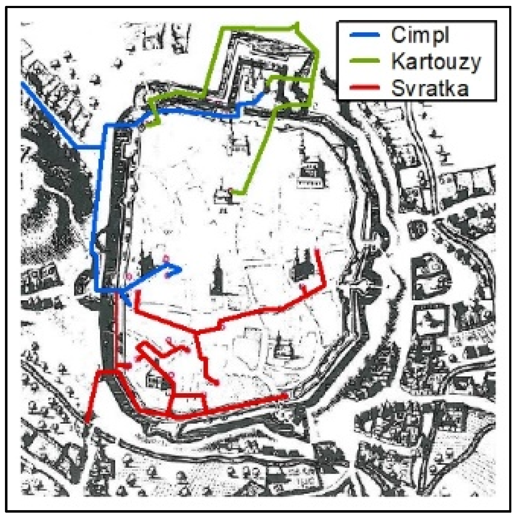
The city of Brno (South Moravia, Czech Republic) is located along several rivers, but for centuries the city had problems with the supply of drinking water. The well-populated city needed not only drinking water but also water for factories and water reserves for fire-fighting purposes. There were two main available water sources—rivers and wells. The first stable water supply system was put into operation at the beginning of the 15th century, and pumped water from the Svratka River. Further good quality water was later brought from two ground water sources north of the city centre—the Cimpl water supply system (a spring at the southern foot of the Kraví Hora hill), and the Kartouzy water supply system (springs and a pond in the Královo Pole city district) [1].
The city of Brno rapidly expanded at the end of the 19th century, which led to a search for a new water source. The search started in the 1880s and 1890s, targeting the town of Březová nad Svitavou, almost 60 km north of the city of Brno. Geological expertise and testing confirmed it as a vast and suitable source of groundwater with excellent water quality. In 1898, the city of Brno decided to carry out a technical and economically notable project of building a 57.5 km long water supply infrastructure—the Březovský Water Supply system I. The planning phase took place between 1896 and 1910, with the opening ceremony of the whole water system taking place in 1913. From that moment, the city of Brno has had a stable source of drinking water with a mean water flow of 250−300 L/s and, together with the Březovský Water Supply system II operational from 1975, a water flow of 1450 L/s [1,2].
The gradual pressure on the water source in Březová nad Svitavou raised several questions about the impact of water pumping on the environment, not only in the closest surrounding areas, but in the entire Svitava River catchment, because the water source captures the groundwater of important natural springs crucial for the Svitava River. These questions were examined by a number of pieces of research [3,4,5,6], and environmental changes were subsequently approved. Most significantly, the hydrological regime of the Svitava River was influenced by the change of spring outflow exacerbated by the great development of cities and industry along the Svitava River [4,5]. Furthermore, the land use of the protection zone of the Březová nad Svitavou water source changed, and there were notable land use changes around all settlements along the Svitava River [6].
Development of settlements during the 20th century in the Czech Republic is connected with the phenomena of the construction of municipal water supplies and water sewers, because of vast city development and the growing consumption of drinking and utility water. This created an urgent need for wastewater disposal and treatment. It can be stated that, as a general truth, the construction of municipal wastewater systems was delayed by decades in relation to the establishment of water supply systems. There is no difference in the case of Brno and its surroundings, which resulted in the massive construction of municipal wastewater treatment plants (WWTPs) only after 1950 in the catchment. An important milestone with regard to the construction of a new treatment plant was Government Order No. 25 from 1975, which established quality standards for water in rivers. New WWTPs were built in great cities. Another important document was the requirement of the European Union to build wastewater treatment plants in all settlements with a total population of 2000 inhabitants or more. This request should have been met by 2010, and the vast majority of municipalities started to build sewerage systems before 2010 [7].
The main aim of this study is to evaluate the impact of the development of a large city and its agglomeration on sources of drinking water, its surroundings and other related areas. The particular aims are (1) description of the historical development of the drinking water supply of Brno in connection with city development from the late 1900s until the present day, and investigation of the impact of groundwater pumping on (2) natural exploitation of groundwater, and (3) the condition of the Svitava River. Without a description of the development of the city’s water supply system, without placing the issue in a historical context, the resulting text would lack context. The intention of the author’s team was to use its interdisciplinary composition to have a more complex grasp of the chosen topic.
2. Methodology
2.1. Research Area
This research was conducted on the two main water supply systems of the city of Brno in the Czech Republic—the Březovský Water Supply system I and II (Figure 1). The water system collects the groundwater from water horizons predominantly composed of alternating layers of sandstone and clay and is on top covered with flood clay with weathered sandstone. This area belongs to the Českotřebovská Highlands, well-known as a great reservoir of groundwater in the Czech Republic due to the suitable geological conditions (alternating layers of sandstone and clay) [5,8].
2.2. Data and Methodology
Historical research has taken place on several levels, including literature searches, which are an integral and standard part of it. In addition, the research was based on the study of primary printed sources or periodicals, which is combined with the use of secondary literature, directly related to the topic or providing a broader socio-economic context, a relevant example of historical work, respectively historical research. The text devoted to the description of the development of the city’s water supply does not represent a compilation of modern secondary literature, but combines several sources of information, completely different sources, different times and purposes, which together allowed to substantiate the specific issues of historical background.
The main text is based on a comprehensive literature search and the collection of information from numerous types of documents found during our research; some of them were provided by the archive of the Brněnské vodárny a kanalizace, a.s. company. The data sets found were statistically analyzed and visualized. The literature search was also added to by the terrain documentation of the current state of accessible facilities of the water supply system investigated. The precipitation and water flow/level data sets provided by the Czech Hydrometeorological Institute (CHMI) were applied.
The route and location of individual water supply facilities were determined on the basis of the original route plan of the water supply provided by the Brněnské vodárny a kanalizace, a.s. company. The individual plan sheets were scanned and joined using the program AutoCAD. In the ArcGIS 10.7 software environment, the merged document was then georeferenced according to basic maps of the Czech Republic 1:10,000, orthophotomaps, a line layer of the water supply route (.shp), and point layer of water supply objects (.shp). Maps of land use change in the water source protection zone of the 1st degree around the water source were created using the DIBAVOD database (layer of water sources protection zones), and individual time sections were created on the basis of maps of the 3rd Austrian Military Mapping 1:25,000 (1876−1880), Topographic maps of Czechoslovakia 1:25,000 (1953−1957), contemporary basic maps of the Czech Republic 1:10,000 (2019), and vector layers from the ZABAGED database from 2019.
The interaction between the river network, especially in the case of the Svitava River, and acting influences within a catchment (e.g., pollution, land management, pumping of drinking water—the Březová nad Svitavou water source) was evaluated over a long term period by the chosen methods based on an assessment of hydrological balance, the analysis of land use changes, the evaluation of water quality and, finally, the impact of pollution discharged from any settlement. The following methodologies were also used for this purpose.
The Saprobic index of macrozoobenthos was taken as a method for evaluation of water quality in the Svitava River catchment during the time period 1970 and 2010 (this paper presents the results of monitoring in the periods 1980−1985, 1990−1995, and 2000−2005). The index expresses the relationship of aquatic invertebrates inhabiting bottom sediments to indicators of organic pollution and the course of decomposition processes [9].
Zoobenthos was monitored through special monitoring of a dense network throughout the Czech Republic [10]. Thirty-six monitored localities were registered for the Svitava catchment area of interest. The saprobic index of zoobenthos was monitored regularly in five-year cycles and a uniform methodology of sampling, processing and calculation of the saprobic index [11] was used throughout. The values of the saprobic index correspond to the degrees of saprobility of water according to the overview in the table [11,12].
At present, water quality studies can take advantage of mathematical modeling. Balance models of substances in streams can provide key information about the current situation, as well as forecasts of the situation in the river network, or the entire river catchment, in the future, especially if there is a lack of necessary empirical data sets. It is valid also for this area of interest. For this reason, we used the results of the application of mathematical modeling to describe the state of water quality in the Svitava River in the period 1995−1996 and forecasts for the period 2003−2004 to analyze the interaction of the water supply system for the city of Brno and water quality in the Svitava River. The analysis was based on the use of various scenarios, such as the value of wastewater discharge from settlements, industrial enterprises and their WWTP. In later years, this approach to water quality assessment was no longer used in the river catchment. The QUAL2E model [13] was used for modeling at the time of the study. The data for modeling included information on the hydraulics of the Svitava riverbed (longitudinal profile of the riverbed, information on stabilization stages and weir structures), characteristics of the transverse profile of the riverbed (measured at regular intervals), location and water flow volume of main tributaries, location and water flow volume of main pollution sources (municipal WWTPs, industrial WWTPs and outlets). Another basis was data on water quality in the river, tributaries and sources of pollution from national databases (e.g., the Hydro-Ecological Information System—set of water management maps 1:50,000, database of the Povodí Moravy, s.e., and the Czech Hydrometeorological Institute). Hydrological and water quality data were processed statistically and converted to the minimum flow Q355 (the statistically based value of water flow achieved 355 days per year). Mathematical modeling and simulations were performed for this characteristic flow, selected as the least favorable state of conditions in the river network.
3. Results
3.1. History of Brno’s Drinking Water Supply System
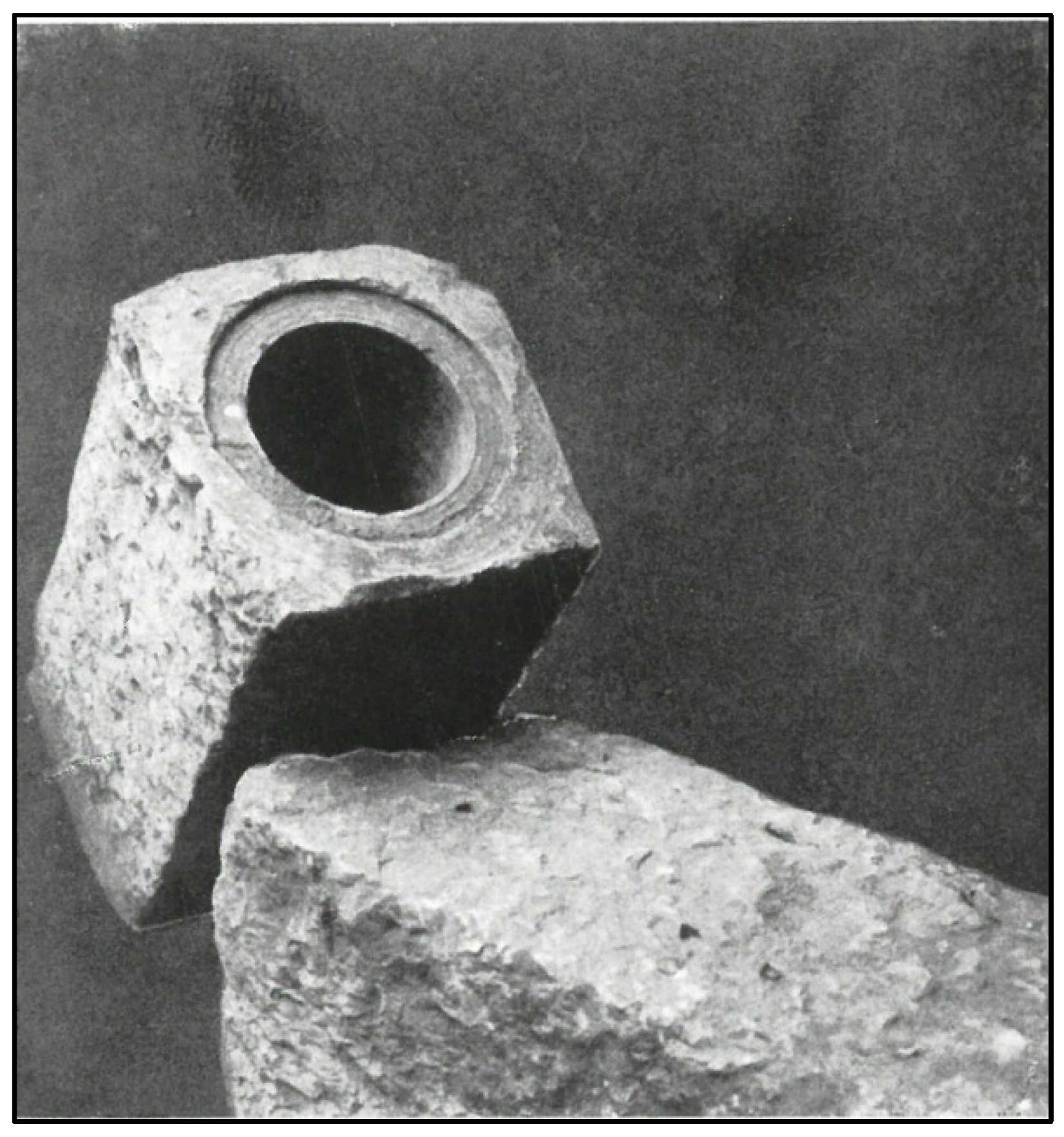
The inception of the water supply system of the city of Brno can be traced to the 14th century when the city suffered from high population density and frequent fires. The first water supply system from the turn of the 15th century brought water south of the Svratka River into two fountains in the city center (Figure 2), and was made of stone (Figure 3). This water supply was added to by the Cimpl water supply system (Figure 2) in the 15th century, which brought water from very abundant north-west springs through an approximately 1 km long wooden pipe. The wooden pipes were changed for cast-iron pipes at the end of the 17th century, although this water supply system was closed at the end of the 19th century because the Svratka water supply system was modified and extended. The last historical water supply system was the Kartouzy water supply system from the 16th century (Figure 2), bringing water north of the Gaisperk pond (the Královo Pole city district) and nearby springs. Daily water production was 213 m3, and this water supply belonged to the monastery of Kartouzy and was used until 1913 [1,14].
Until the 19th century wells in the courtyards and cellars of town houses were also an important source of water for the population. Due to the lack of sewers, the water from these wells was often unhealthy and caused the spread of infectious diseases. In 1877, Professor Habermann tested the water from the Brno wells and found nineteen completely defective samples from twenty samples. Indeed, harmful substances from nearby waste cesspools seeped into the wells. He, therefore, recommended filling the wells and using only water from the public water supply [15].
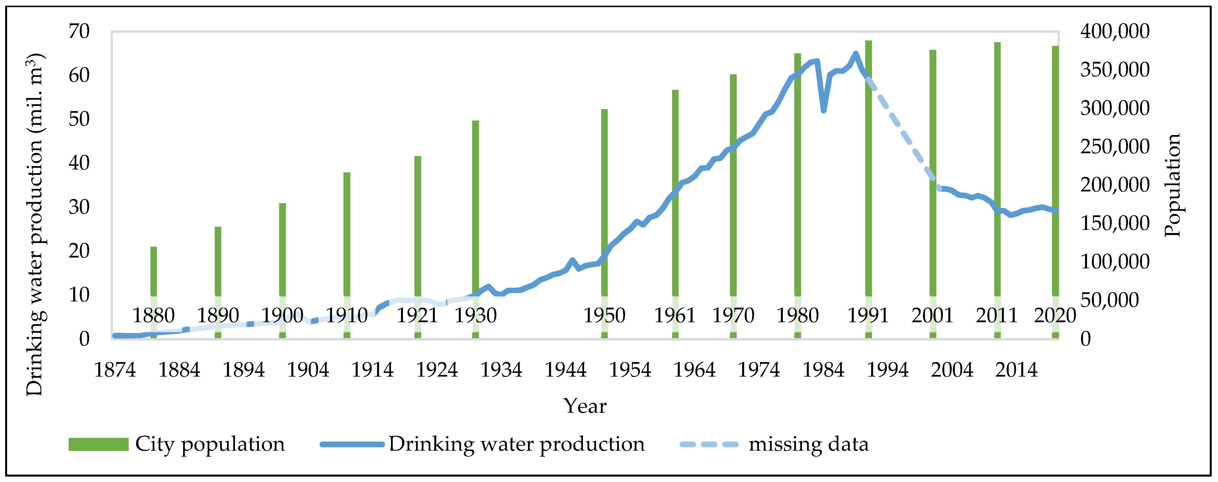
The city of Brno went through a great development in the 19th century due to the growth of the city’s importance as one of the biggest industrial centers in Central Europe, which put great pressure on the city’s water supply system. For this reason, city representatives proceeded to construct a vast water treatment plant. The water treatment plant was built between 1869 and 1872 by Thomas Docwry from London, and it was located on the Svratka River in the Pisárky city district. The water from the treatment plant (205 m above mean sea level) was pumped into two underground reservoirs (255 m above mean sea level) at Žlutý kopec hill with a total storage capacity of 18,359 m3, and two underground reservoirs (280 m above mean sea level) at Špilberk Castle with a total storage capacity of 2162 m3 [14]. The daily production of drinking water was 16,950 m3. Nevertheless, these capacities were sufficient only until the beginning of the 19th century. The development of the city was great, which is demonstrated by the growth in city population between 1874 and 2020 (Figure 4). Due to that situation, city representatives started to search for another new source of drinking water, which resulted in the Březovský Water Supply system I. The Pisárky water treatment plant was in operation until 2013 [16].
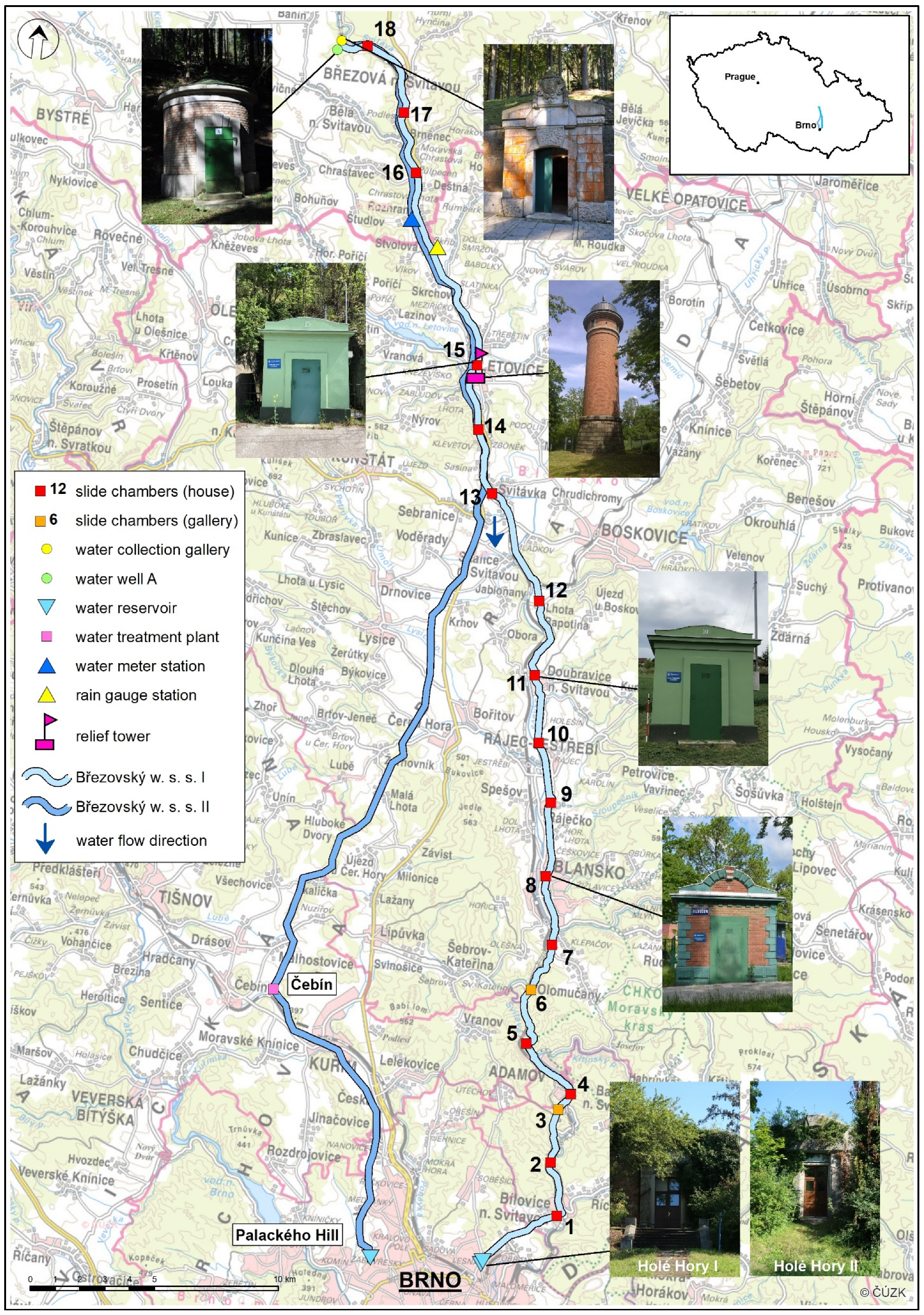
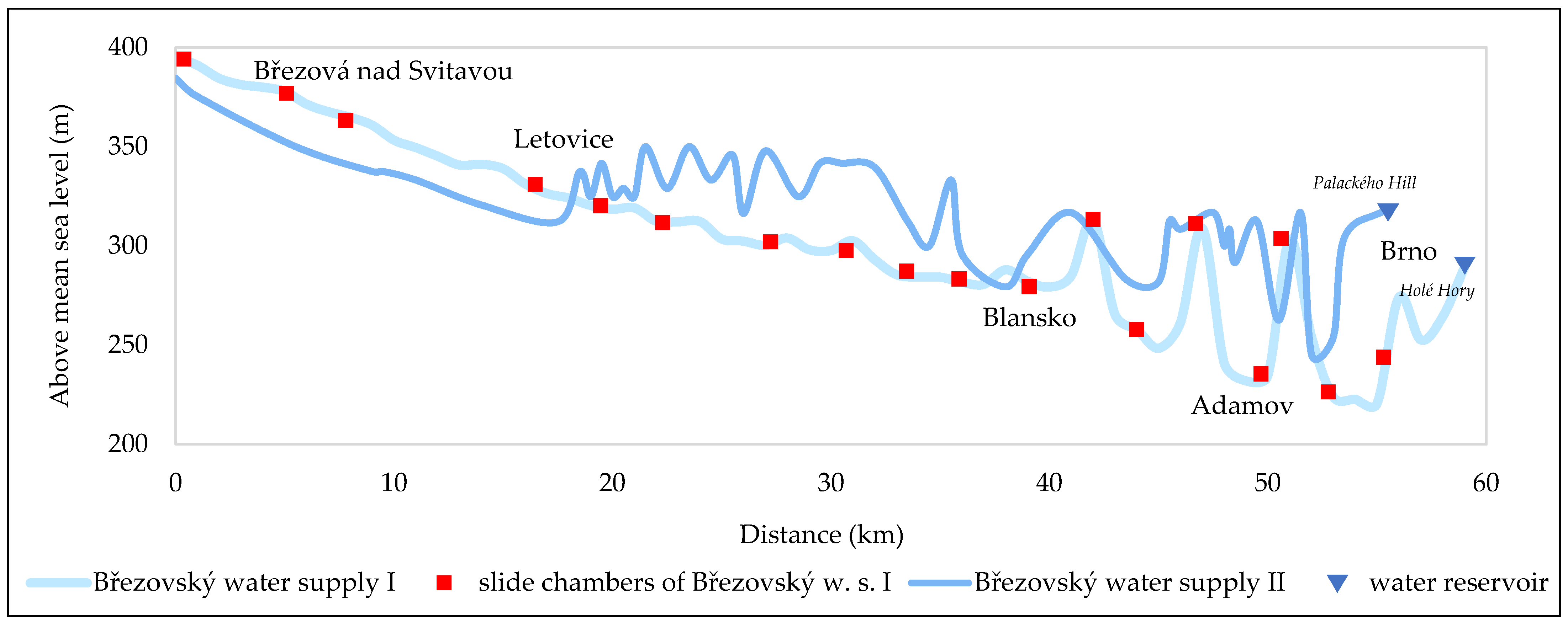
The need for a new water supply system emerged at the turn of the 20th century, because of the continued growth in population and industrial development (Figure 4), and due to the deteriorating water condition of the Svratka River. The sufficient source of drinking water was found approximately 60 km north of Brno, near the town of Březová nad Svitavou, and specifically in the village of Banín. The preparatory work began in 1896, which consisted of detailed research and testing of the pumping of groundwater. Finally, the main construction was undertaken between 1904 and 1913, and the original name of the water supply was “Die Kaiser Franz Joseph I.-Trinkwasserleitung” after the Emperor Francis Joseph I until 1918. The current official name is the Březovský Water Supply system I. The Březovský Water Supply system I (Figure 1) is the oldest part of the current water supply system of the city of Brno. This almost 58 km long water supply was built between 1911 and 1913 near the town of Březová nad Svitavou, and the main purpose is to bring drinking water to the city of Brno. The water supply is composed of a 57.5 km long cast-iron pipeline (Figure 5), 18 slide chambers placed in 16 small green-colored service houses and two embossed galleries, and one 20 m tall relief tower located in the city of Letovice (Figure 1). The water supply starts in the water collection gallery with 13 water wells, pumping water from depths of between 17 m to 21 m; the fourteenth well (the “A well”) is located in a separate construction (Figure 1). The water is led south through the valley of the Svitava River to the city of Brno and, finally, the water is accumulated in two large underground reservoirs—Holé Hory I and II (Figure 1). The daily water production is about 21,600 m3 (maximum flow of 300 L/s). The water is transported gravitationally and the height difference between the collecting gallery in Březová nad Svitavou and the underground reservoirs in Brno is 89 m (Figure 6) [5,6,8].
The daily water production of 21,600 m3 was sufficient until the 1970s. As the development of the city of Brno continued through the 20th century, the need for additional new water sources emerged. That is why the second water supply system (the Březovský Water Supply system II) from Březová nad Svitavou was built between 1972 and 1975 with a total daily water production of 93,312 m3. The Březovský Water Supply system II (Figure 1) is a 55.4 km long ferroconcrete pipe and it was built between 1972 and 1975. The groundwater is pumped by 28 water wells from two water horizons—a deep horizon between depths of 80 m to 130 m, and a shallow horizon with depths of between 12 m to 18 m. The daily water production is about 93,312 m3 (maximum flow of 1140 L/s), and water is stored in two underground reservoirs at the Palackého vrch hill in the northwest part of the city of Brno, where water is mixed with water from the other water supply system—the Vír Regional Water Supply system. The water is transported partly gravitationally and the height difference between the wells in Březová nad Svitavou and underground reservoirs in Brno is 66.5 m (Figure 6) [5,6,8].
The Pisárky water treatment plant was gradually stopped at the turn of the 21st century due to the deteriorating water conditions of the Svratka River (Table 1), and the construction of Vír Regional Water Supply system between 1988 and 2000 [1,14,16]. The development of the main paths of the water supply system of Brno is presented in Figure 7.
3.2. Environmental and Social Consequences of a Drinking Water Supply
3.2.1. City Growth and Water Supply System Development
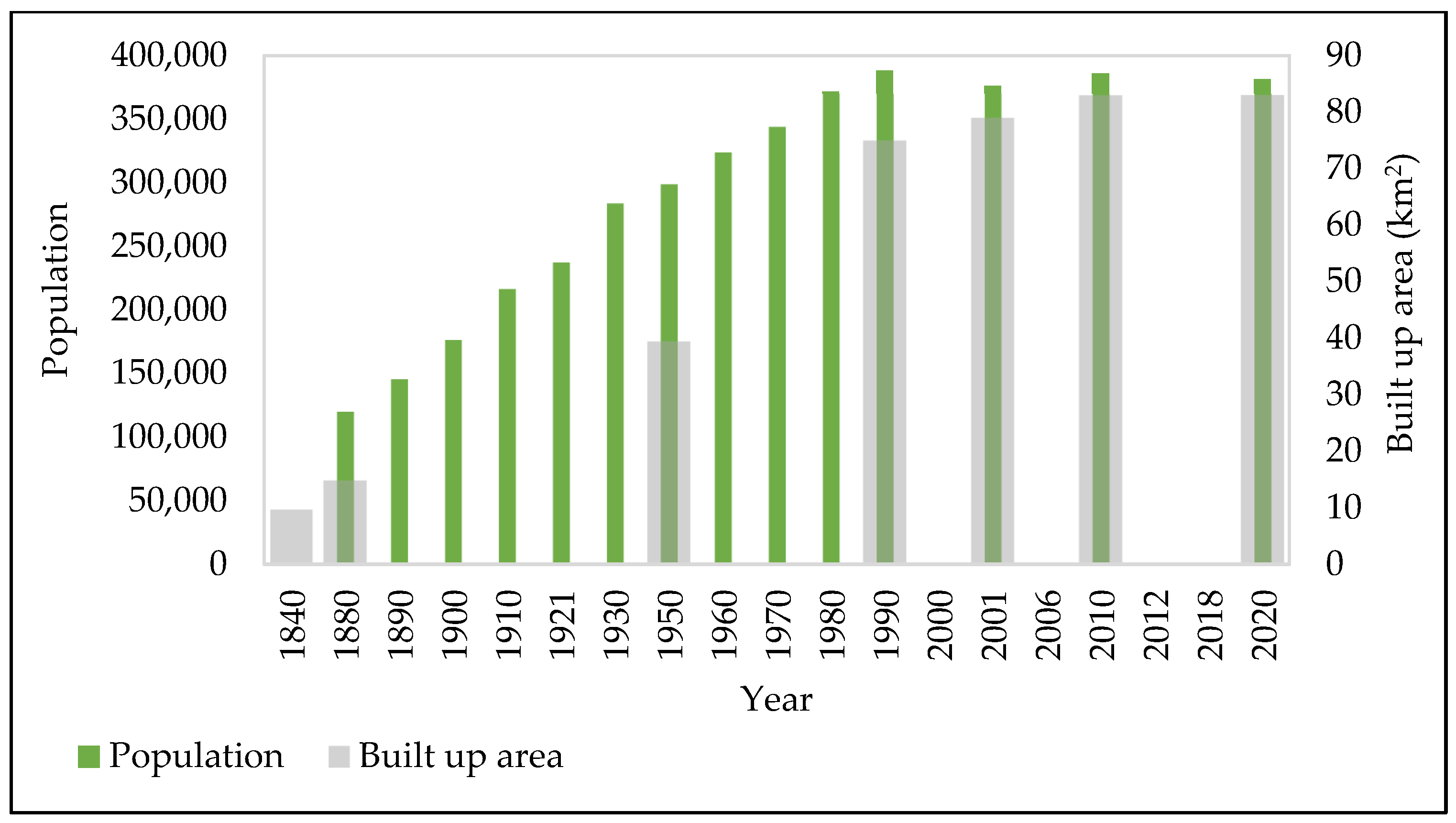
The city of Brno has developed dramatically during the last 200 years, and become the second most important city of the Czech Republic. The enormous expansion of the city was caused by the industrial boom in the 19th century, when the city became a center of the textile industry (the nickname “Moravian Manchester” was created) [18]. In addition, the engineering industry spread out, and the city of Brno became an important center in Central Europe. The city’s progression is evident from the development of the population together with the expansion of built-up areas in Figure 8; the increasing trend in both categories is obvious until the 1990s when it started to stagnate. This great development of the city would not have been so dramatic if two strategic things had not been secured—a stable source of drinking water and wastewater treatment.
In connection with the administrative expansion of the city in 1850, when all the suburbs in its immediate vicinity were annexed to it, the municipality was forced to address the issue of water distribution to this area. The city expanded from its original 141 hectares to 1816 hectares, although only 40 hectares of the city area (the old city center within the city walls) was supplied with drinking water. The total city population rose from the original 13,000 to almost 50,000. In addition, the city peaked economically at this time, and the dominant textile, leather, and engineering industries enormously increased demand, especially water for technological processes. The only temporary solution was the extension of the river (Svratka) water supply network to the city’s industrial sector, which has been taking place gradually since 1853. The water supply capacity was undersized and the water quality, especially in the summer months, did not meet drinking water criteria [19,20].
A move forward came about due to the construction of the Pisárky water treatment plant between 1869 to 1872 through the project of the London builder Thomas Docwra. The input raw water was taken above the weir in Kamenný Mlýn mill at the Svratka River and treated through open biological filters, originally three, and later supplemented by other open and covered filtration areas (with a total area of 9605 m2). The treated water was pumped into two pressure zones, into the underground reservoirs on Žlutý kopec hill and Špilberk Castle. The city acquired higher quality, filtered river water, and expanded its supply capacity and distribution network. Water could also begin to perform its public functions better (street cleaning, watering orchards, supplying fountains and urban water features, supplying municipal and public buildings, flushing sewers, etc.). However, it was still true that many houses were left without a water connection (in 1900, 665 of the 2989 houses in the city were without water), among them mainly large rental buildings with many apartments in the suburbs (barracks inhabited by workers), which ultimately meant half of the housing units without a connection. It was available to them from public spouts, but it was still true that it was primarily utility water. Due to the persistent epidemics of typhus and cholera in the city, it was decided the whole city would be connected to a completely new source of hygienically adequate drinking water. The city intended to get rid of its label as one of the most dangerous places in Moravia in terms of the spread of typhus epidemics [2,21,22,23].
After 1919, when the second administrative expansion of the city limits took place and the so-called Greater Brno was established (increase of the city area from 1816 hectares to 12,376 hectares; increase of the population by more than a third to 220,000). This raised the issue of newly connected settlements on water lines. This happened gradually from the 1920s onwards, when the well water originally used was replaced. In 1929, the daily capacity of the Březovský Water Supply system I was increased to 300 L/s. During this time, it was also possible to expand the utility water supply system from the Pisárky water treatment plant to the higher, northern parts of the city, the permitted supply capacity of which was around 200 L/s [1,18,19].
In the interwar era, the Pisárky water treatment plant underwent reconstruction and the increased capacity of 770 L/s became an alternative source of drinking water for the heavily developing city. City peripheries and surrounding settlements (e.g., Modřice, Kuřim) were gradually connected to the Brno water supply system. By the end of the 1960s, the daily water consumption increased to 1656 L/s, and despite the further expansion of the Pisárky water treatment plant to a capacity of 1650 L/s, it was necessary to implement the Březovský Water Supply system II, which was already considered in the interwar era. After a hydrological survey (1953–1968), a project was implemented in 1970 which included the construction of the Letovice reservoir near the city of Letovice, which was to improve the flow of the Svitava River and replace the water captured by the newly built feeder. The Březovský Water Supply system II, with a length of over 55 km, was put into operation in 1975. Its capacity was set at an average of 780 L/s. Since the end of the 1970s, the city has had 1080 L/s of Březová and 1400 L/s of Pisárky water (in total almost 2500 L/s). However, due to the enormous population growth in the 1970s and 1980s, these resources were unable to cover consumption. In 1983, for the first time ever, the city was forced to announce regulatory measures in water abstraction, when water consumption (in 1982 over 2300 L/s) threatened the capacity limits of resources. As a result of rising demands, the long-delayed implementation of the Vírský regional water supply system was started using the Vír reservoir on the Svratka River (water treatment plant in Švařec). The construction, which began in 1988, was completed in 2000. A number of settlements are connected to this water supply system with treated surface water and its individual branches. In connection with its commissioning, the role of the typing plant was gradually reduced (and definitively abolished in 2013) [1,16,18,19,24].
3.2.2. Land Use Change
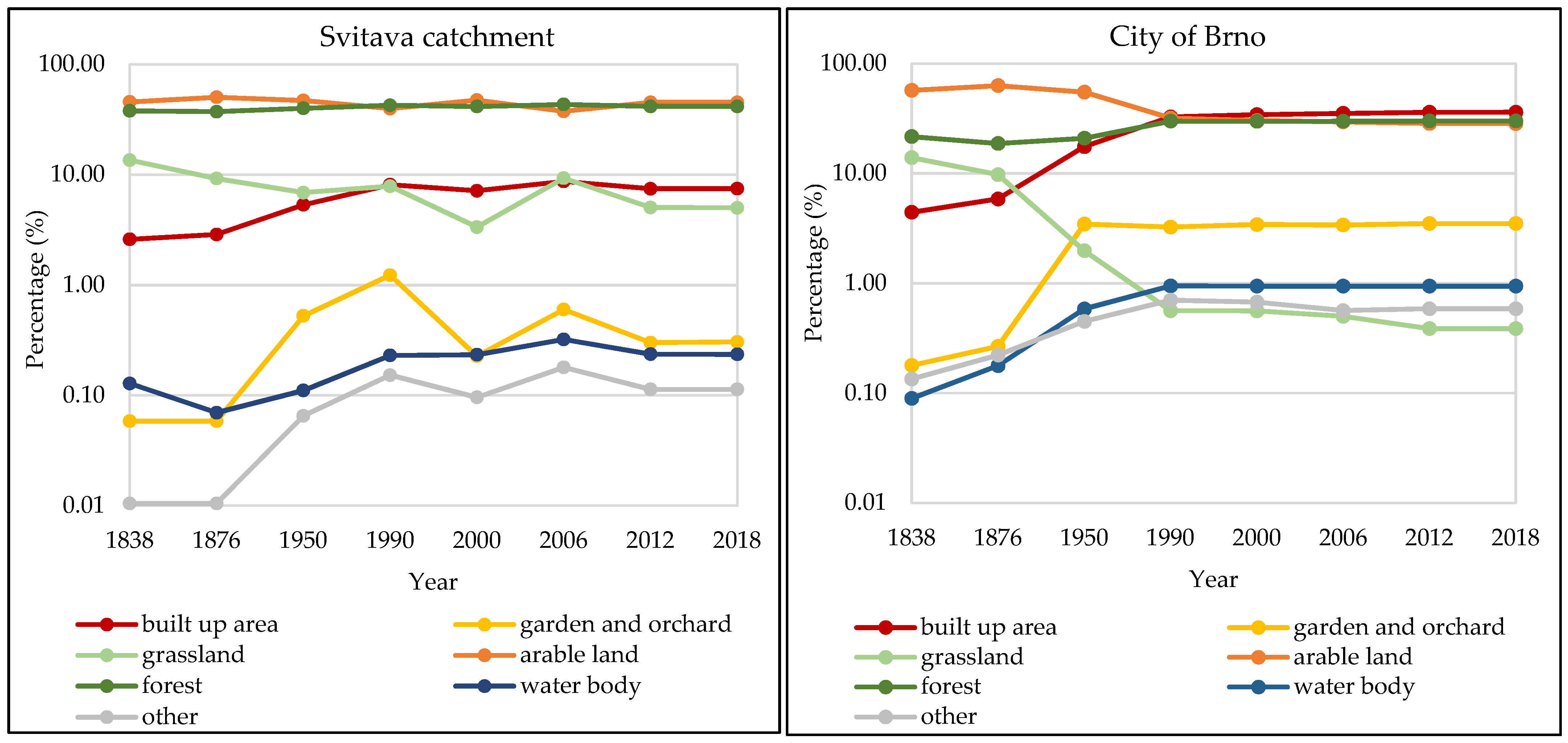
Land use change is the most visible environmental change in the landscape. In the case of the Svitava catchment, the vast land use change is connected with the development of populated areas (Figure 9). The main force was industrialization along the Svitava River, which brought more people into populated areas. It can be stated that larger settlements have a greater impact on the landscape. Furthermore, there is a slight increase in water surface area caused by the establishment of small ponds and the construction of two reservoirs—Letovice and Boskovice. From the 1990s, land use is mostly defined by the spread of built-up areas at the expense of grassland, gardens or orchards, and arable land.
Similar land use development can be found in the case of Brno. Nevertheless, there was a great reduction of grasslands between 1876 and 1950 (Figure 9). These areas were changed into gardens or orchards near to the rising number of houses, which is connected with the increasing size of the built-up area in total, added to by the rise of other areas (factories, etc.). The water body areas slightly increased, especially due to the construction of the Kníničky (or Brno) reservoir between 1936 and 1940.
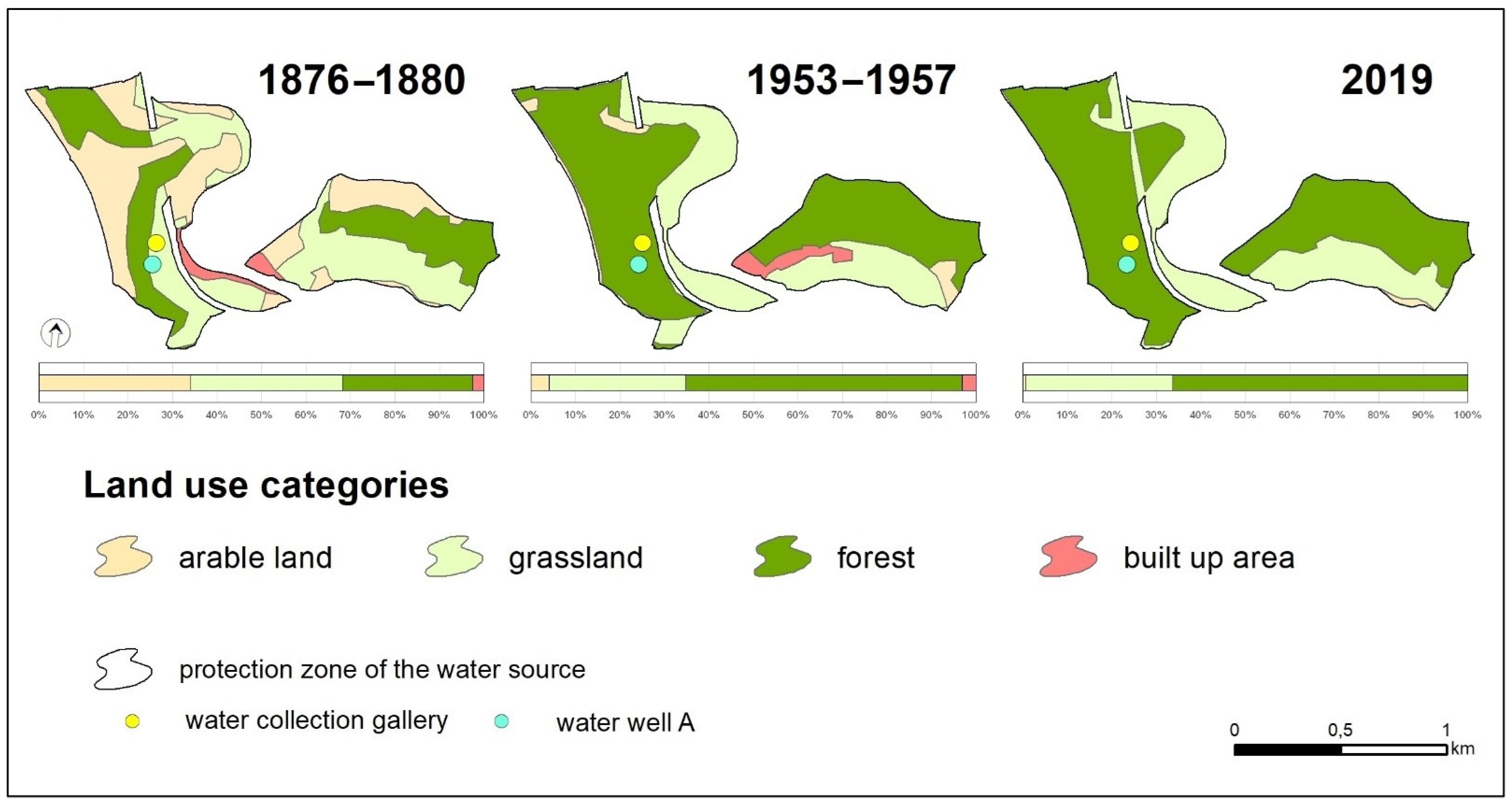
In the case of the water source in Březová nad Svitavou, the land use change is connected with the water source protection zone of the highest protection of 1st degree (Figure 10). The biggest changes occurred during the construction of the Březovský Water Supply system I between 1910 and 1913, when steep parts were covered by forest, and flat parts (mostly along the Svitava River) were covered by grass. A big part of the village of Muzlov was destroyed and its inhabitants moved away. The protection zone was extended by 50 hectares in 1938, and 2.5 km of riverbed was modified between 1935 and 1936 [1]. Modifications included the industrial center of the town of Svitavy being relocated higher up because there was a great danger of groundwater contamination by infiltration of the polluted water from the river. This threat remained until the construction of a WWTP in Hradec nad Svitavou (the WWTP for the whole Svitavy agglomeration) in the late 20th century. The last development of land use in the protection zone was connected with the end of the Second World War when Muzlov was completely destroyed and forested. This transformation was facilitated, among other things, by the displacement of the German population from the area after 1945. The current state of land use derives from the 1970s after the construction of the Březovský Water Supply system II.
3.2.3. Changes of Spring Outflow and River Flow
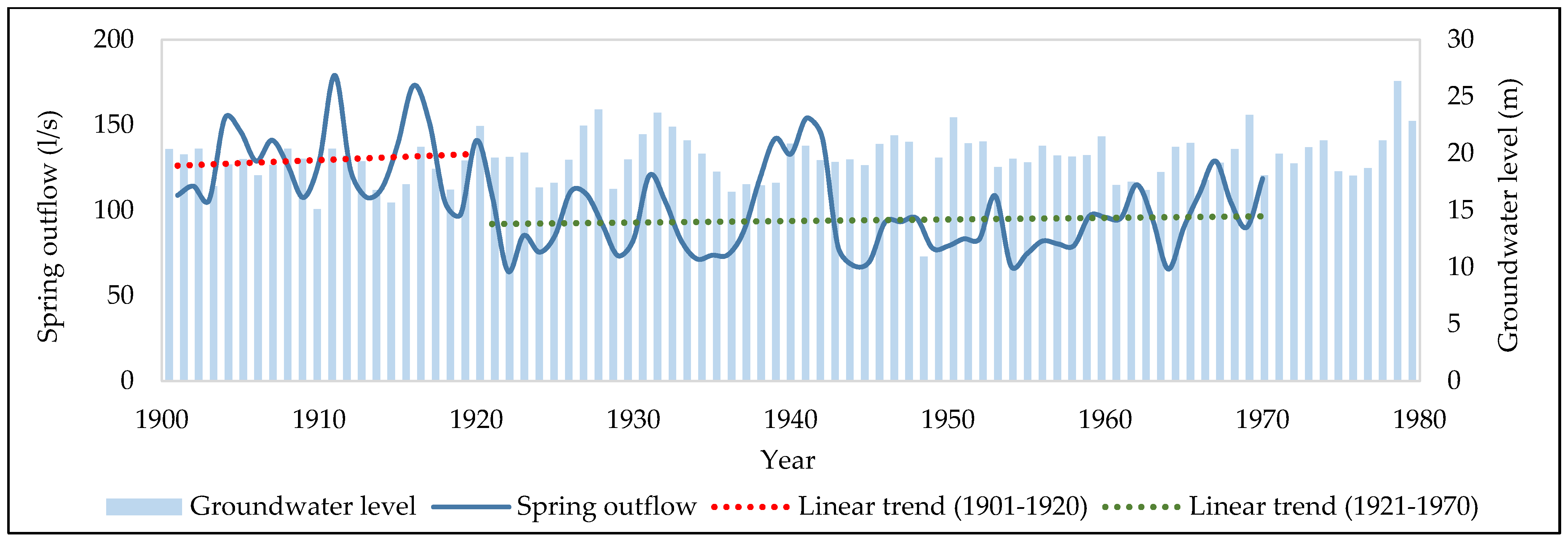
The pumping of ground water at the Březová nad Svitavou water source influences natural processes of the hydrological cycle—in this case, the water flow in the Svitava River. The water source is located in the main source area of the river, which was characterized by several springs (e.g., Sulkovy s., Hladové s., Petrovy s., Banínské s.), but only the Hladové springs remained. The Březovský Water Supply system I completely captured water from the Banínské springs, and the Březovský Water Supply system II completely captured water from the Petrovy and Luční springs. The graph in Figure 11 presents a decrease of the Sulkovy springs outflow after the commissioning of the first water supply in 1913. A rapid decline of spring outflow came out after a few years of water supply operation (threshold in 1920), and the mean outflow reduced from the original 129.6 L/s to 94.2 L/s (a reduction of almost 30%; Table 2).
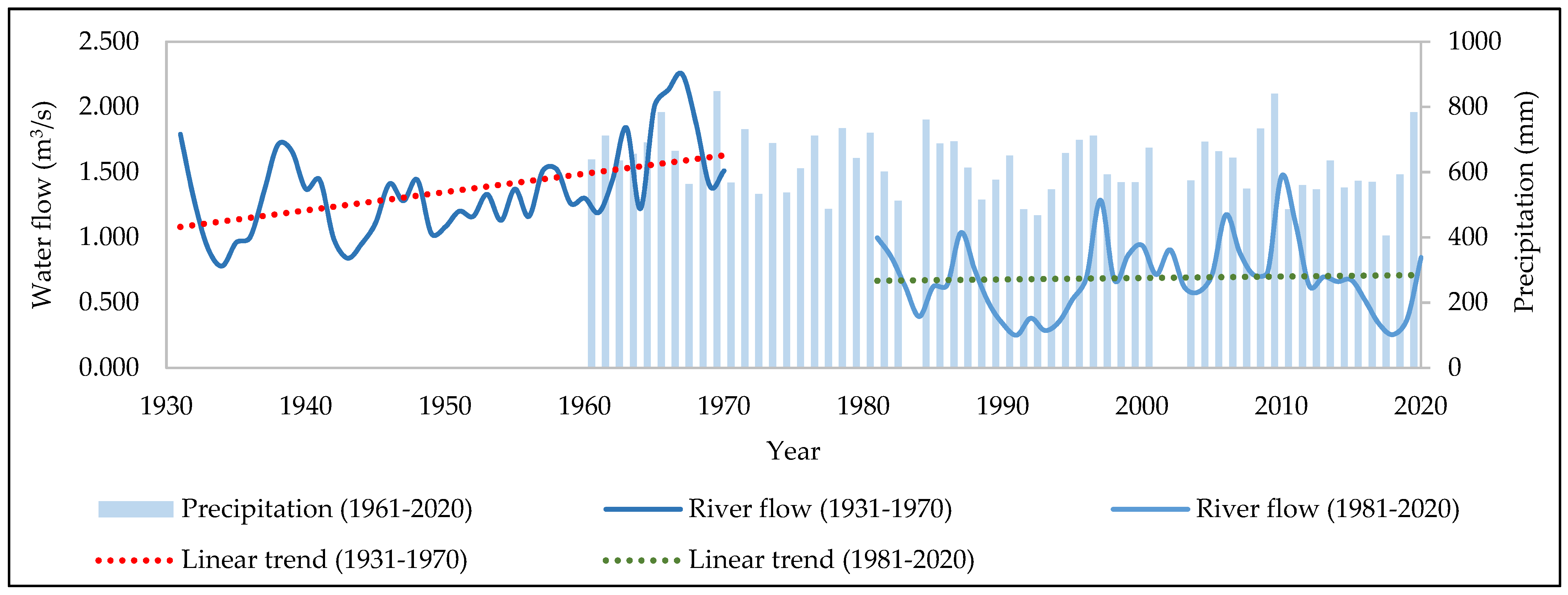
Consequently, the water flow of the Svitava River changed as well. Nevertheless, the data for a particular time period before 1930 does not exist in the case of river flow. A similar process of river flow reduction appeared after the commissioning of the Březovský Water Supply system II in 1975, which is presented in Figure 12. The decrease of water flow was from the original 1.35 m3/s to 0.69 m3/s (a reduction of almost 50%; Table 3). The change was great, although it had been taken into account before the construction of the water supply, and that is why the Letovice reservoir was built on the right tributary (the Křetínka River) of the Svitava River between 1972 and 1976 near the city of Letovice. The main purpose of the reservoir is the donation of the water flow volume of Svitava River, flood protection, production of electricity, and recreation [3,26].
3.2.4. Pollution in the Svitava River
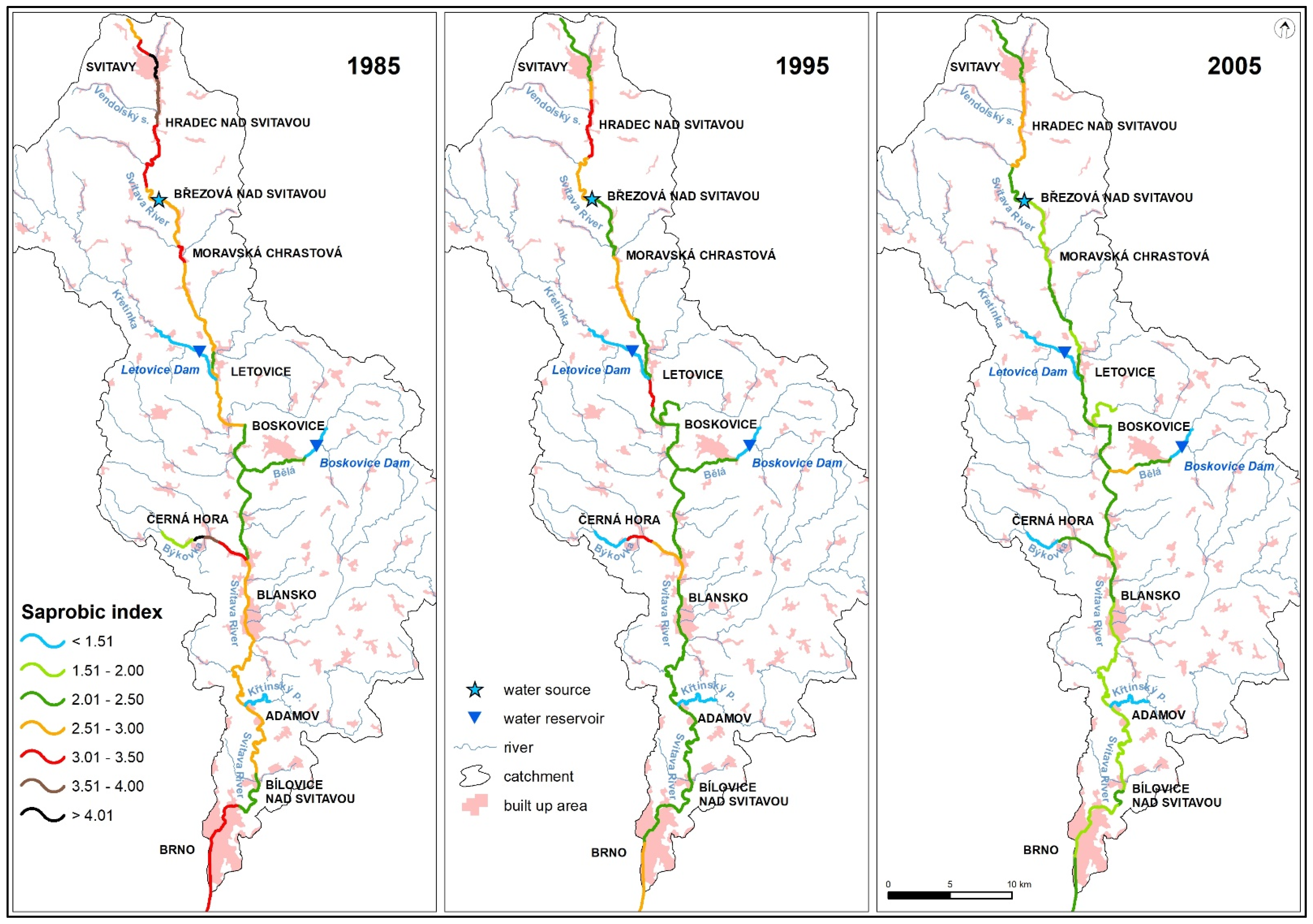
Figure 13 shows the development of the oxygen regime of the Svitava River and some tributaries over time. Data on zoobenthos communities in streams were used to prepare these maps. Throughout the period from the 1970s to the measures taken in the period 2000−2004, they represented a significant burden of wastewater from the town of Svitavy (with an impact on the spring area), from the textile industry located along the river (especially around the town of Letovice) and the Býkovka tributary with wastewaters of the town of Černá Hora.
The map for 1985 (Figure 13) shows probably the worst situation that has long been found in this catchment. It corresponds to the availability of running drinking water and other modern equipment in households, the development of the machinery and textile industry, as well as the intensification of processes in agriculture. At the same time, the construction of sewerage networks and treatment plants lagged behind. The significant negative impact of larger cities and the food industry can also be seen.
In 1995, there was a significant improvement in the oxygen regime, especially in the upper reaches of the Svitava River (Figure 13). The reduction of wastewater pollution from the town of Svitavy also contributed to the development of self-cleaning processes and the improvement of the quality of the flow through the Březová nad Svitavou water source. Overall, industry and agriculture in the whole catchment are in a slight decline during this period. The morphology of the river, its flow in a deep forested shaded valley further improves the oxygen conditions in the section below the town of Blansko. A clear improvement is also evident in the flow of the Svitava River through the city of Brno, where some operations were gradually closed or connected to the sewerage system.
In the last map for 2005 (Figure 13), the oxygen regime of streams is already approaching their natural state and the possibilities of self-cleaning processes in streams. Further improvements can only be expected on a local scale.
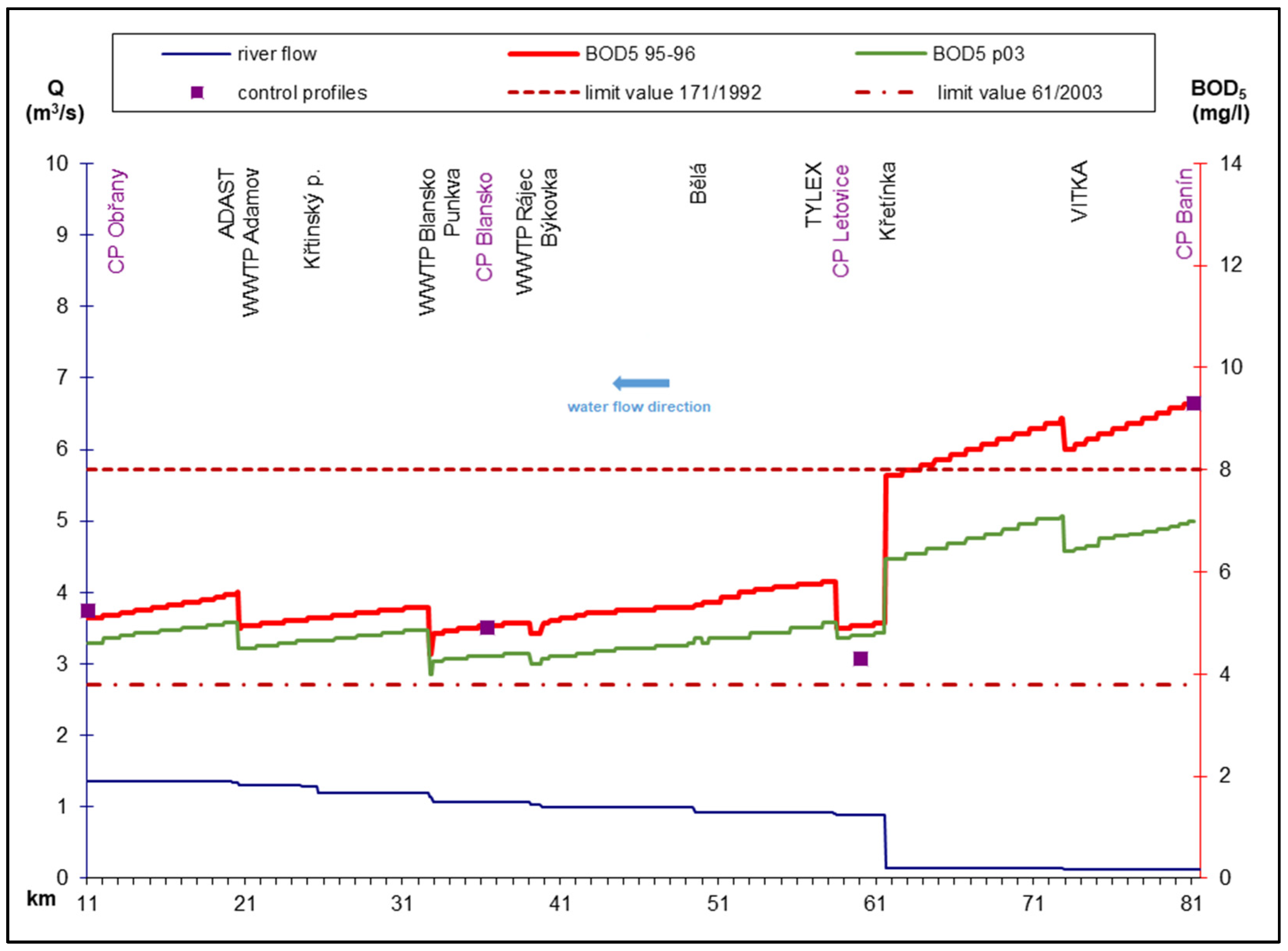
Figure 14 and Figure 15 document the course of pollution by organic substances (parameter BOD5) and eutrophic elements (total phosphorus−Ptot was chosen as a representative). Both the current situation in the mid-1990s (BOD5 95–96 and Ptot 95–96) and the prognosis of the possible development of river pollution after the introduction of appropriate measures (BOD5 p03 and Ptot p03) were modeled, especially the improvement of drainage and efficiency of wastewater treatment from settlements. It is clear from the courses that increasing the efficiency of WWTP treatment for the agglomeration of the town of Svitavy would lead to an improvement in the conditions in the upper section of the stream, which is also essential for the Březová nad Svitavou water source. That this happened is confirmed by the water quality map in the river basin in 2005 (Figure 13). The course of pollution of the Svitava River also shows the significant effect of improving the flow regime and diluting pollution by discharging water from the Letovice reservoir. Thanks to this measure, self-cleaning was (and is) being supported up to the industrial area above the city of Brno (between the town of Blansko to the town of Adamov).
In a later period, after the change in the water quality monitoring system in the Czech Republic, similar quality models and predictions of its development were no longer compiled. The following findings emerged from the basic monitoring in the case of the Svitava River.
The Svitava River was monitored in six profiles in the two years of 2009 and 2010. The stream has had a high content of organic pollution in the upper section for a long time, mainly due to municipal pollution and low dilution capacity. Due to self-cleaning processes, the water quality beyond the town of Letovice is improving, but in the next section, the pollution increases again or remains at the same level. Ammonia nitrogen and total phosphorus, indicators of eutrophication of the aquatic environment, showed the lowest average (median) concentrations since 1994. However, the flow of phosphorus content is still in the III to IV quality class [12]. The course of pollution is as follows−the worst condition in the upper section of the stream, a significant decrease below the town of Letovice and constant pollution in the lower section. In the two years 2015 and 2016, the river was monitored in seven profiles. The flow in the upper section is of poor quality, mainly due to high municipal pollution and low dilution capacity. Due to self-cleaning processes, the water quality after the town of Letovice is improving, but in the next section, the pollution is increasing again or remains at the same level. In the two years 2019 and 2020, higher pollution was no longer mentioned. There were modifications in the wastewater disposal of settlements and the reconstruction of the WWTP, as described in the next part of the study.
3.2.5. Wastewater Collection and Treatment System
Within the research area of the Svitava catchment, the development of sewers was connected mainly with the town of Svitavy. Remains of drainage of houses in Svitavy can be seen from the time of building the center. During the reconstruction of historic houses, stone gutters covered with stone slabs and sealed with clay screed were discovered, which can be considered as the primordial sewerage system of cities [27]. In Svitavy, the old sewer was a system of open ditches and these stone gutters. In most settlements, especially in small villages, however, the first sewerage systems were built, practically always a unified sewerage system, only in the second half of the 20th century, in the 1960s and 1970s. The predominant materials were earthenware and reinforced concrete pipes. During reconstructions, often to separate sewer systems, these are exchanged for new types of pipes [7].
The first WWTP in the area of interest is the treatment plant used by the municipality of Březina. It was established near the Březinka mining site for the new housing estate of the Moravian fireclay company and was allegedly completed as early as 1956. It was a slotted tank with upstream hand-wiped coarse screens, i.e., mechanical pre-treatment of wastewater with digestion space for settled solid particles, feces and other impurities. At present, Březina is a part of the municipality of Slatina village (Pardubice region), which has built a new sewerage system and activation treatment plant, but located outside the catchment area of interest [7].
The most important settlements in the area, the towns of Svitavy and Blansko, were acquired by treatment plants in 1976 (by the Hungarian company, Duviép Veszprem) for most of the territory of Svitavy and from 1965 gradually for Blansko. The first WWTP in Blansko was built from 1965 to 1966. At this time, the main sewage collector was built on Svitavská Street, supporting the individual sewer branches. On 7 September 1965, the then operator, the District Water Management Administration of Blansko, took over the operation of the Kamenolom pumping station. This was followed by commissioning, connection, and other parts of the sewers. The peculiarity is that the treatment plant was and still is built on a hill above the city and all water must be pumped into it from the Kamenolom gas station with a displacement of 600 m to a height of 35 m. The original location is retained. The treatment plant was built in accordance with the then requirements for water purity with an emphasis on the elimination of carbon and nitrogen pollution. It served its purpose without major interventions in technology until the 1990s. Over the years, new residential zones of the developing Blansko, the Blansko-North housing estate in 1967, Zborovce gradually until 1976, Podlesí in 1981, Písečná in 1984, and new districts of Blansko, Klepačov in 1989, were connected to the treatment plant. Těchov and Obůrka in 1988 and the rest in 2002. In Blansko itself, the situation of Old Blansko remained unresolved, where a backbone sewage collector and sewer for rainwater drainage were built in 1975, but without connection to a wastewater treatment plant [7].
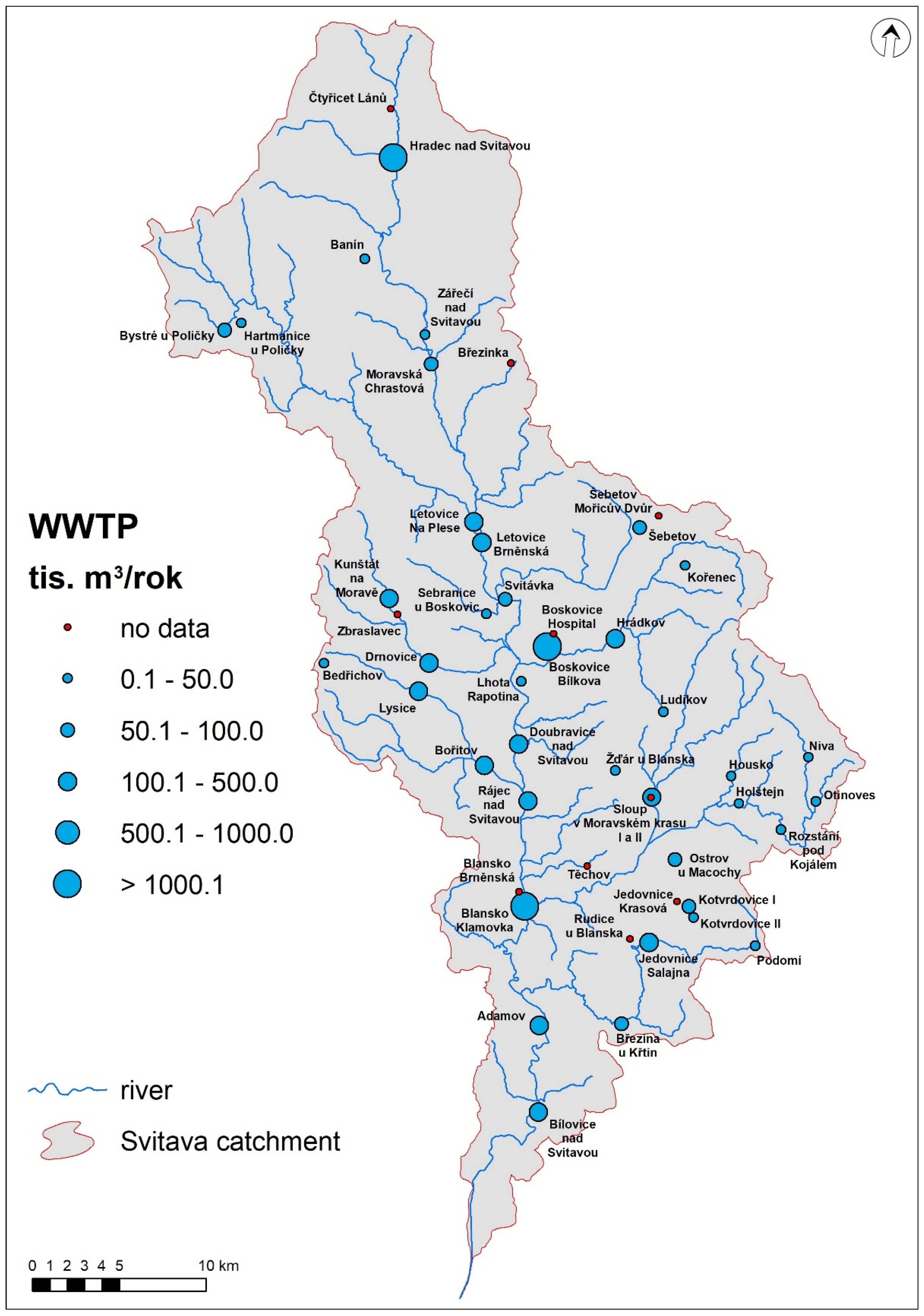
Both aforementioned main treatment plants in the river basin, as well as others, built in the 1960s to 1980s, underwent significant and fundamental reconstruction, associated with the intensification of treatment processes and increased treatment efficiency in the 1990s and, then especially after the accession of the Czech Republic to the EU, from 2004. A significant milestone in the financing of reconstruction was the adoption of the project, “Water Protection of the Dyje River Basin” (2004−2008). Since 2010, a number of settlements have acquired their own smaller treatment plants, and according to the web application of the Ministry of Agriculture “Odběry a vypouštění” [28], 49 wastewater treatment plants are registered in the area (Figure 16).
However, a detailed analysis of the area revealed that 39 WWTPs are in operation and the majority of these plants operate on the principle of treatment plants with denitrification + nitrification + phosphorus precipitation, which are the cases for larger settlements, or in the case of smaller sites activating wastewater treatment plants with nitrification and denitrification. There was also a wastewater treatment plant in the river basin representing the so-called natural methods of wastewater treatment [29] in the village of Kořenec, which has been operating since the mid-1990s. In this case, however, between the years 2012 to 2015, the mechanical pre-treatment facilities were converted into standard activation wastewater treatment plants. Gravel filters with wetland vegetation still serve to finalize the wastewater treatment plants outflow [7].
4. Discussion
Regarding a comprehensive overview of the issue of pollution in the river basin, its spread and the interrelationship of influences and their response, many studies were carried out abroad with a comparable intention in approximately the same period towards the end of the 20th century. For example, a water quality improvement plan for the Tha Chin river basin in central Thailand has been studied by using integrated land-use and water quality modeling [30]. Loading reduction scenarios were applied to find out the appropriate loading reduction target and hence the improved water quality in the main stream. Biological indicators have also been used to describe the quality of the aquatic environment in the river basin for a long time [31,32]. The diversity indices calculated for each type of analysis ultimately reflect the relationship between the various aspects of assessing community structure in relation to the gradient of hydrochemical or climatic indicators of the environment [33,34,35].
The advantages of evaluating the quality of flowing surface waters using biological indicators lie mainly in the fact that the indicators make it possible to detect the effects comprehensively and for a certain, longer period of time, thus expressing the quality of the aquatic environment in the medium term. The length of this time depends on the indicator organism used—algae will provide shorter-term information than, for example, macrozoobenthos [12]. The saprobic index of macrozoobenthos expresses the relationship of aquatic invertebrates inhabiting bottom sediments to indicators of organic pollution and the course of decomposition processes.
The saprobic index primarily indicates organic pollution, but also positively correlates with the intensity of eutrophication, the agricultural use of river floodplains and river basins, and some elements of hydromorphological degradation. The disadvantage of this system is that it does not distinguish between natural and man-made organic pollution. The value of the saprobic index naturally increases with the river order and the size of the river catchment, so it is more accurate in evaluating the resulting value of saprobic index with respect to the type of flow. Currently, the saprobic index of macrozoobenthos, as well as the evaluation of phytobenthos, is part of multimetric indices, which are used for type-specific assessment of the ecological status/potential of water bodies for the needs of water planning [10,34].
The available data on pollution sources, always for the relevant time period and the mathematical modeling of water quality in the Svitava River in the period between 1995 and 1996 and with the forecast of development in the period between 2003 and 2004, served as a further basis for this analysis. The modeling in these time periods corresponded to the view of the quality of the aquatic environment and ecological problems from the early 1990s. With the increase in ecological problems, considerable attention has been paid worldwide to the issue of water quality during this period. One of the goals of solving these projects was to compile materials and create tools aimed at improving the current quality of water, including their ecosystems. The results obtained were to be the basis for creating conditions for the channeling of funds in the given river basin, which was done in connection with the Czech Republic’s accession to the EU, i.e., since 2004.
5. Conclusions
This paper presented the connection between the development of big industrial settlements, the need for a drinking water source, and the impact on the river environment. This connection was presented via the example of the city of Brno, which has rapidly developed in the last almost 200 years thanks to its growing economical and industrial importance since the 19th century. The city’s development precipitated the need for a stable and wealthy source of water, which resulted in construction of three main water supply systems from two different water sources. Nevertheless, the rising pressure on water sources caused environmental changes, especially with regard to river conditions.
The idea of using the source area of the Svitava River as the basic source of water for the Brno agglomeration arose 140 years ago and entered into operation more than 100 years ago. During this time, the water supply system has expanded, proved its viability and can be expected in the future. Although it brought some restrictions along its route, and it contributed to the development not only of Brno but of the entire affected area.
As follows from the overall assessment of the quality of the aquatic environment of surface waters in the Svitavy River catchment, a comprehensive approach to assessment, based on biological indicators, mathematical modeling and on the study of social-historic data and consequences, has proved its worth. Modeling can provide the partial information needed to decide on the possible contamination of spring areas and on the possible impact of discharged pollution at lower flows in the river network (e.g., reduced water abstraction for water supply systems). In its time, it provided the necessary data for the direction of measures to protect the spring of the Březová nad Svitavou water source, but also to reduce the impact of ground water pumping for the water supply system to the reduction of flow in the river. The favorable effect of the implementation of the Letovice reservoir for the improvement of flows and water quality in the river network was also confirmed. In the example of the Svitava River, the impact of ground water pumping, together with settlement development and industrial upswing, on the spread of pollution in the river was demonstrated. Finally, the paper presented the need for a proper wastewater treatment system, which can lead to restoration of river condition, and, consequently, of the entire environment.
In addition, this paper provided a great example of collaboration between different scientific disciplines and their own manners of social-environmental investigation, which resulted in a complex description of the chosen research topic. This multidiscipline approach can help to search for unexpected problems (their impacts and solutions) during the planning phase. It can be an inspiration for other studies.
Author Contributions
Conceptualization, D.H., M.R. and M.F.; methodology, D.H., M.R. and M.F.; formal analysis, D.H.; investigation, M.F. and A.V.; resources, M.R. and A.V.; data curation, D.H., M.R. and M.F.; writing—original draft preparation, D.H. and M.R.; writing—review and editing, M.F. and A.V.; visualization, D.H.. All authors have read and agreed to the published version of the manuscript.
Funding
This research has been supported by the research grant NAKI II–DG18P02OVV019 provided by the Ministry of Culture of Czech Republic.
Institutional Review Board Statement
Not applicable.
Informed Consent Statement
Not applicable.
Data Availability Statement
Most of the entry data and texts, maps and other graphic appendices presented here are created with the permission of the Brněnské vodárny a kanalizace, a.s. company, and only for the needs of the NAKI II project (DG18P02OVV019). For further use or distribution of project results, it is necessary to inform the Brněnské vodárny a kanalizace, a.s. company.
Acknowledgments
The research has been supported by the research grant NAKI II–DG18P02OVV019 provided by the Ministry of Culture of Czech Republic.
Conflicts of Interest
The authors declare no conflict of interest.
References
- Machař, J.; Nezval, V.; Helcelet, M.; Jandl, J.; Jandlová, M.; Káňová, E.; Karásek, M.; Kříž, L.; Kubeš, M.; Mrkva, I.; et al. Voda pro Brno, 1st ed.; Brněnské Vodárny a Kanalizace, a.s.: Brno, Czech Republic, 1992. [Google Scholar]
- Stadtrate der Landeshauptstadt Brünn. Die Kaiser Franz Joseph-Trinkwasserleitung in Brünn; Stadtrate der Landeshauptstadt Brünn: Brünn, Czech Republic, 1913. [Google Scholar]
- Tálská, E.; Chlum, A.; Krčmář, A. Vodní dílo Křetínka u Letovic, 1st ed.; MLVH ČSR: Prague: Czech Republic, 1981. [Google Scholar]
- Krčmář, A.; Kříž, H. Studia Geographica 89: Vliv Gografických Podmínek na Využívání Podzemní vody v Jímacím Území u Březové nad Svitavou, 1st ed.; Českoslovesnká akademie věd (Geografický ústav): Brno, Czech Republic, 1987. [Google Scholar]
- ČSVTS. 75 Let Březovského Vodovodu pro Město Brno, 1st ed.; ZP ČSVTS: Brno, Czech Republic, 1988. [Google Scholar]
- Velešík, M. Historický Vývoj Březovských Vodovodů; ÚPOL: Olomouc, Czech Republic, 2012. [Google Scholar]
- Dzuráková, M.; Vyskočil, A.; Havlíček, M.; Pavelková, R. Historické Vodohospodářské Objekty v Povodí Svitavy; project No. DG18P02OVV019; Ministry of Culture: Praha, Czech Republic, 2020.
- Viščor, P. 100 let I. březovského vodovodu. Sovak 2013, 3, 1–4. [Google Scholar]
- Hegab, M.H.; Khalifa, N. Applicability of using biological indices to assess water quality of the Nile branches. Egypt. Pak. J. Biol. Sci. 2021, 24, 383–393. [Google Scholar] [CrossRef] [PubMed]
- Zahrádková, S.; Hájek, O.; Treml, P.; Pařil, P.; Straka, M.; Němejcová, D.; Polášek, M.; Ondráček, P. Hodnocení rizika vysychání drobných vodních toků v České republice (Risk assessment of drying up of small streams in the Czech Republic). VTEI 2015, 57, 4–16. [Google Scholar] [CrossRef]
- ČSN 75 7716 (Czech National Normative). Jakost Vod–Biologický Rozbor–Stanovení Saprobního Indexu (Water Quality–Biological Analysis–Determination of Saprobic Index); ČNI: Praha, Czech Republic, 1998. [Google Scholar]
- Mičaník, T.; Hanslík, E.; Němejcová, D.; Baudišová, D. Klasifikace kvality povrchových vod (Classification of surface water quality). VTEI 2017, 59, 4–11. [Google Scholar] [CrossRef]
- Olowe, K.O. Assessment of Some Existing Water Quality Models. Nat. Environ. Pollut. Technol. 2018, 17, 939–948. [Google Scholar]
- Gottwald, L.; Klimeš, V.; Machař, J.; Borčický, V.; Hádek, J.; Hůrka, V.; Chrástecký, L.; Malý, J.; Müller, Q.; Pleský, M.; et al. Vodovody a Kanalizace Města Brna 1872–1972, 1st ed.; Vodohospodářská Správa Města Brna: Brno, Czech Republic, 1972. [Google Scholar]
- Petránová, A.; Forejtníková, M.; Ošlejšková, J. Náhradní Zdroje Vody v Obcích v Krizových Situacích–Využití Původních Zdrojů a Pramenů; Výzkumný Ústav Vodohospodářský, T.G., Ed.; Masaryka: Prague, Czech Republic, 2014. [Google Scholar]
- BVK. 100 Let I. Březovského Vodovodu: 1913–2013, 1st ed.; Brněnské Vodárny a Kanalizave, a.s.: Brno, Czech Repiblic, 2013. [Google Scholar]
- Růžková, J.; Škrabal, J.; Balcar, V.; Havel, R.; Křídlo, J.; Pavlíková, M.; Šanda, R. Historický Lexicon Obcí České Republiky 1869–2005, 1st ed.; Český Statistický Úřad: Prague, Czech Republic, 2006; pp. 618–619. [Google Scholar]
- Archiv Města Brna. Dějiny Brna 6.–Předměstské obce, 1st ed.; Archiv Města Brna: Brno, Czech Republic, 2017. [Google Scholar]
- Vacek, B. Velké Brno Hygienické a Sociální; Bohumil Vacek: Brno, Czech Republic, 1925. [Google Scholar]
- Brněnských Vodáren. Zásobování Vodou Zemského Hlavního Města Brna; Brněnských Vodáren: Brno, Czech Republic, 1927. [Google Scholar]
- d’Elvert, C. Neu Brünn; Verlag der Histor [isch]-Statist [ischen] Section: Brno, Czech Republic, 1888. [Google Scholar]
- Volksfreund. Volksfreund Newspaper, 5 November 1907; p. 4.
- Fasora, L. Svobodný Občan ve Svobodné Obci? Matice Moravská: Brno, Czech Republic, 2007. [Google Scholar]
- BVK. 130 Let Historie a Siučasnost Vodáren a Kanalizací v Brně, 1st ed.; Brněnské Vodárny a Kanalizace, a.s.: Brno, Czech Republic, 2002. [Google Scholar]
- Havlíček, M. Změny ve využití krajiny v Brně a okolí. In Proceedings of the GIS Ostrava 2008, Ostrava, Czech Republic, 27–30 January 2008. [Google Scholar]
- PMO–VD Letovice. Available online: http://www.pmo.cz/cz/o-podniku/vodni-dila/letovice/ (accessed on 24 August 2021).
- Broncová, D. Historie Kanalizací. Dějiny Odvádění a Čištění Odpadních vod v Českých Zemích; Milpo Media: Prague, Czech Republic, 2002. [Google Scholar]
- EAGRI–Odběry a Vypouštění (Web Application). Available online: http://eagri.cz/public/web/mze/voda/aplikace/odbery-a-vypousteni.html (accessed on 23 August 2021).
- Kadlec, R.H.; Wallace, S. Treatment Wetlands, 2nd ed.; CRC Press: Boca Raton, FL, USA, 2009. [Google Scholar]
- Wongsupap, C.; Weesakul, S.; Clemente, R.; Das Gupta, A. River basin water quality assessment and management: Case study of Tha Chin River Basin, Thailand. Water Int. 2009, 34, 345–361. [Google Scholar] [CrossRef]
- Dulič, Z.; Mitrović-Tutundžić, V.; Marković, Z.; Živić, I. Monitoring water quality using zooplankton organism as bioindicatiors at the Dubica fish farm, Serbia. Arch. Biol. Sci. 2006, 58, 245–248. [Google Scholar] [CrossRef]
- Mustapha, A.; Aris, A.Z.; Juahir, H.; Ramli, M.F.; Kura, N.U. River water quality assessment using environmentric techniques: Case study of Jakara River Basin. Environ. Sci. Pollut. Res. 2013, 20, 5630–5644. [Google Scholar] [CrossRef] [PubMed]
- Protasov, A.A.; Barinova, S.; Novoselova, T.; Sylaieva, A.A. The Aquatic Organisms Diversity, Community Structure, and Environmental Conditions. Diversity 2019, 11, 190. [Google Scholar] [CrossRef] [Green Version]
- Jerves-Cobo, R.; Córdova-Vela, G.; Iniguez-Vela, X.; Diaz-Granda, C.; van Echelpoel, W.; Cisneros, F.; Nopens, I.; Goethals, P.L.M. Model-Based Analysis of the Potential of Macroinvertebrates as Indicators for Microbial Pathogens in Rivers. Water 2018, 10, 375. [Google Scholar] [CrossRef] [Green Version]
- Vassoney, E.; Mochet, A.M.; Rocco, R.; Maddalena, R.; Vezza, P.; Comoglio, C. Integrating Meso-Scale Habitat Modelling in the Multicriteria Analysis (MCA) Process for the Assessment of Hydropower Sustainability. Water 2019, 11, 640. [Google Scholar] [CrossRef] [Green Version]
Figure 1.
The Březovský water supply systems and the location in the Czech Republic (photo: Honek, D., 2020).
Figure 1.
The Březovský water supply systems and the location in the Czech Republic (photo: Honek, D., 2020).

Figure 2.
The three main water supply systems (Cimpl, Kartouzy and Svratka) in the center of the city of Brno at the end of the 16th century (according to [1]).
Figure 2.
The three main water supply systems (Cimpl, Kartouzy and Svratka) in the center of the city of Brno at the end of the 16th century (according to [1]).

Figure 3.
The stone pipe from the 15th century (according to [1]).
Figure 3.
The stone pipe from the 15th century (according to [1]).

Figure 4.
The growth of the population of the city of Brno and total drinking water production of the Brněnské vodárny a kanalizace, a.s. company between 1874 and 2020 (according to [1,17]).

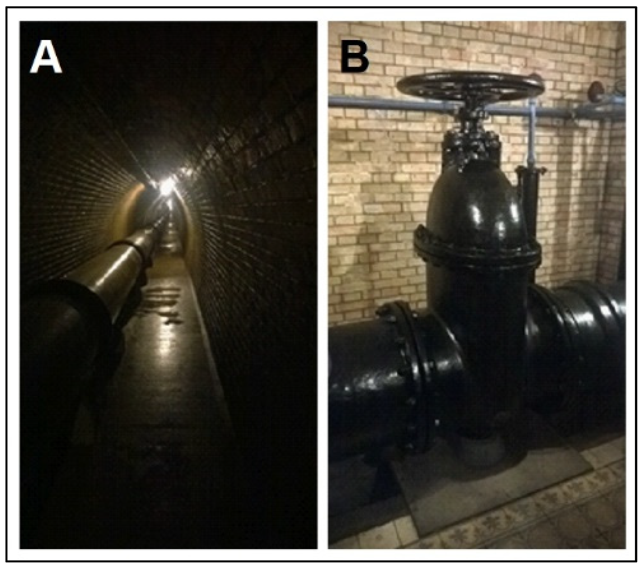
Figure 5.
The cast-iron pipeline of the Březovský Water Supply I—(A) in the water collection gallery, and (B) the water cap (photo: Honek D., 2019).
Figure 5.
The cast-iron pipeline of the Březovský Water Supply I—(A) in the water collection gallery, and (B) the water cap (photo: Honek D., 2019).

Figure 6.
Longitudinal profiles of both Březovský Water Supply systems (based on archived documents from the Brněnské vodárny a kanalizace, a.s. company).
Figure 6.
Longitudinal profiles of both Březovský Water Supply systems (based on archived documents from the Brněnské vodárny a kanalizace, a.s. company).

Figure 7.
Development of the main routes of the water supply system of the city of Brno between the 1900s and 2020s [1,14]. Water supply system routes in 1902, 1913 and 1926 are only diagrams of a specific operating system at a given time without connection to other supply systems. The route in 2020 is based on ZABAGED database.

Figure 8.
Development of the city population and the built up area of the city of Brno between 1840 and 2020.
Figure 8.
Development of the city population and the built up area of the city of Brno between 1840 and 2020.

Figure 9.
Land use changes of the Svitava catchment and the city of Brno (current cadastral area) between 1838 and 2018 (data before 1990 based on [25]).
Figure 9.
Land use changes of the Svitava catchment and the city of Brno (current cadastral area) between 1838 and 2018 (data before 1990 based on [25]).

Figure 10.
Land use changes in the water source protection zone of 1st degree in Březová nad Svitavou between 1876 and 2019.
Figure 10.
Land use changes in the water source protection zone of 1st degree in Březová nad Svitavou between 1876 and 2019.

Figure 11.
Development of outflow of the Sulkovy springs and groundwater level in the V2 well between 1901 and 1980 (according to [4]).
Figure 11.
Development of outflow of the Sulkovy springs and groundwater level in the V2 well between 1901 and 1980 (according to [4]).

Figure 12.
Mean yearly water flow of the Svitava River at the Rozhraní station, and the annual amount of precipitation at the Stvolová-Skřib station between 1931 and 2020.
Figure 12.
Mean yearly water flow of the Svitava River at the Rozhraní station, and the annual amount of precipitation at the Stvolová-Skřib station between 1931 and 2020.

Figure 13.
Development of the zoobenthos saprobility index in the Svitava River from 1985 to 2005.

Figure 14.
Longitudinal profile of the water quality (organic pollution parameter BOD5) of the Svitava River, km 11.0–81.0 in the period from 1995 to 1996 and prognosis of the water quality changes for the period from 2003 to 2004. The Svitava River tributaries: Křetínka, Bělá, Býkovka, Punkva, Křtinský p.; municipal WWTPs: Rájec, Blansko, Adamov; industrial and municipal WWTP: TYLEX Letovice; industrial WWTP: ADAST; water quality checkpoint at the Svitava River in the settlements: Banín, Letovice, Blansko, Brno-Obřany.

Figure 15.
Longitudinal profile of the water quality (eutrophication parameter total phosphorus) of the Svitava River, km 11.0–81.0 in the period from 1995 to 1996 and prognosis of the water quality changes for the period from 2003 to 2004. The Svitava River tributaries: Křetínka, Bělá, Býkovka, Punkva, Křtinský p.; municipal WWTPs: Rájec, Blansko, Adamov; industrial and municipal WWTP: TYLEX Letovice; industrial WWTP: ADAST; water quality checkpoint at the Svitava River in the settlements: Banín, Letovice, Blansko, Brno-Obřany.

Figure 16.
Wastewater treatment plants of the Svitava catchment in 2020 (outflow data based on Odběry a vypouštění web application administrated by the Ministry of Agriculture).
Figure 16.
Wastewater treatment plants of the Svitava catchment in 2020 (outflow data based on Odběry a vypouštění web application administrated by the Ministry of Agriculture).


Table 1.
Changes of input drinking water qualitative characteristics of the Svratka River in the Pisárky water treatment plant between 1949 and 1975; and qualitative characteristics of groundwater in the Březová nad Svitavou water source between 1924 and 1971 (long term mean values based on monitoring of the Brněnské vodárny a kanalizace, a.s. company).
| Parameter | Units | Pisárky | Březová | |||||
|---|---|---|---|---|---|---|---|---|
| 1949–1954 | 1955–1959 | 1960–1964 | 1965–1969 | 1970–1971 | 1975 | 1924–1971 | ||
| colour | Pt/L | 35 | 39.2 | 30.6 | 34.4 | 30 | 34.81 | 2.41 |
| turbidity | mg SiO2/L | 47.9 | 83.2 | 66.8 | 34.2 | 63 | 45.32 | 2.41 |
| pH | - | 7.3 | 7.23 | 7.21 | 7.37 | 7.48 | 7.42 | 7.25 |
| biochemical oxygen demand | mg O2/L | 6.51 | 5.48 | 6.06 | 4.82 | 4.72 | 4.54 | 1.14 |
| total hardness | °N | 5.68 | 5.42 | 5.68 | 7.64 | 8.6 | 8.59 | 12.45 |
| total suspended solids | mg/L | 138.6 | 174 | 215.8 | 238 | 259 | 531 | 269.16 |
| ammonia | mg/L | 0.05 | traces | 0.1 | 0.18 | 0.22 | 0.22 | - |
| iron | mg/L | 0.25 | 0.28 | 0.34 | 0.22 | 0.32 | 0.27 | 0.02 |
| chlorides | mg/L | 11 | 12.2 | 15 | 17.8 | 21.5 | 29.35 | 8.76 |
| nitrite | mg/L | traces | 0.12 | 0.25 | 0.11 | 0.2 | 0.15 | - |
| nitrates | mg/L | 8.2 | 12.7 | 7.6 | 8.4 | 6.3 | 20.85 | 17.83 |
Table 2.
Mean monthly and annual spring outflow of the Sulkovy springs between 1901 and 1970 ([4]; CHMI).
Table 2.
Mean monthly and annual spring outflow of the Sulkovy springs between 1901 and 1970 ([4]; CHMI).
| Time Period | Mean Monthly Outflow (L/s) | Mean Annual Outflow (L/s) | |||||||||||
|---|---|---|---|---|---|---|---|---|---|---|---|---|---|
| XI | XII | I | II | III | IV | V | VI | VII | VIII | IX | X | ||
| 1901–1920 | 122.1 | 126.8 | 126.9 | 127.4 | 132.6 | 143.2 | 139.7 | 131.2 | 128.7 | 126.0 | 123.0 | 122.9 | 129.6 |
| 1921–1970 | 87.4 | 85.1 | 84.5 | 91.3 | 100.0 | 106.9 | 103.7 | 99.1 | 97.4 | 94.9 | 93.4 | 88.2 | 94.2 |
Table 3.
Mean monthly and annual flow of the Svitava River between 1931 and 2020.
| Time Period | Mean Monthly Flow (m3/s) | Mean Annual Flow (m3/s) | |||||||||||
|---|---|---|---|---|---|---|---|---|---|---|---|---|---|
| XI | XII | I | II | III | IV | V | VI | VII | VIII | IX | X | ||
| 1931–1970 | 1.21 | 1.19 | 1.21 | 1.46 | 1.92 | 1.61 | 1.45 | 1.36 | 1.29 | 1.21 | 1.18 | 1.15 | 1.35 |
| 1981–2020 | 0.53 | 0.56 | 0.65 | 0.70 | 0.99 | 0.82 | 0.75 | 0.68 | 0.74 | 0.63 | 0.57 | 0.57 | 0.69 |
Publisher’s Note: MDPI stays neutral with regard to jurisdictional claims in published maps and institutional affiliations. |
© 2021 by the authors. Licensee MDPI, Basel, Switzerland. This article is an open access article distributed under the terms and conditions of the Creative Commons Attribution (CC BY) license (https://creativecommons.org/licenses/by/4.0/).
Share and Cite
MDPI and ACS Style
Honek, D.; Forejtníková, M.; Rozkošný, M.; Vyskočil, A. Historical Water Supply System of the City of Brno—Social-Environmental Consequences. Water 2021, 13, 3550. https://doi.org/10.3390/w13243550
AMA Style
Honek D, Forejtníková M, Rozkošný M, Vyskočil A. Historical Water Supply System of the City of Brno—Social-Environmental Consequences. Water. 2021; 13(24):3550. https://doi.org/10.3390/w13243550
Chicago/Turabian StyleHonek, David, Milena Forejtníková, Miloš Rozkošný, and Aleš Vyskočil. 2021. "Historical Water Supply System of the City of Brno—Social-Environmental Consequences" Water 13, no. 24: 3550. https://doi.org/10.3390/w13243550
Note that from the first issue of 2016, this journal uses article numbers instead of page numbers. See further details here.