
Groundwater Impacts and Management under a Drying Climate in Southern Australia


1
Grounded in Water, Adelaide, SA 5064, Australia
2
CSIRO Land and Water, Adelaide, SA 5064, Australia
3
CSIRO Land and Water, Canberra, ACT 2601, Australia
4
Jacobs, Melbourne, VIC 3000, Australia
*
Author to whom correspondence should be addressed.
Water 2021, 13(24), 3588; https://doi.org/10.3390/w13243588
Submission received: 12 November 2021
/
Revised: 8 December 2021
/
Accepted: 8 December 2021
/
Published: 14 December 2021
(This article belongs to the Special Issue Integrated Water Assessment and Management under Climate Change)
Abstract
:The trend to a hotter and drier climate, with more extended droughts, has been observed in recent decades in southern Australia and is projected to continue under climate change. This paper reviews studies on the projected impacts of climate change on groundwater and associated environmental assets in southern Australia, and describes groundwater planning frameworks and management responses. High-risk areas are spatially patchy due to highly saline groundwater or low-transmissivity aquifers. The proportional reduction in rainfall is amplified in the groundwater recharge and some groundwater discharge fluxes. This leads to issues of deteriorating groundwater-dependent ecosystems, streamflow depletion, reduced submarine discharge, groundwater inundation and intrusion in coastal regions and reduced groundwater supply for extraction. Recent water reforms in Australia support the mitigation of these impacts, but groundwater adaptation is still at its infancy. Risk management is being incorporated in regional water and groundwater management plans to support a shift to a more sustainable level of use and more climate-resilient water resources in affected areas. The emerging strategies of groundwater trade and managed aquifer recharge are described, as is the need for a national water-focused climate change planning process.
1. Introduction
The impacts of climate change on groundwater have been receiving increasing international interest over the last twenty years, as seen in scientific reviews [1,2,3,4,5,6,7,8,9]. The potential impacts include exacerbating water scarcity [10,11,12,13,14], flooding, ref. [15] sea water intrusion [16] and deteriorating groundwater-dependent ecosystems [17]. The impacts on water scarcity are of a particular concern for areas where groundwater is an important water source. Examples include arid and semi-arid regions already under stress from existing extraction, such as the southern USA [12], Middle East and northern Africa [13] and southern Europe [14]. The management options for water scarcity are generally known, but climate change may accelerate the need for policy and management changes.
This paper describes how climate change is affecting groundwater in southern Australia, its potential contribution to water scarcity and the steps being taken to manage the issue. South-western Australia has been experiencing a drying climate for last forty years, and south-eastern Australia has been in drought for much of the last twenty years [18]. Climate modelling is indicating that this trend will continue [19]. Climate change affects the groundwater balance both directly through changes in rainfall magnitude and patterns and temperature and indirectly through sea level rise, demand for groundwater and changes in land and water management [4]. There have already been major impacts on water resources in the Perth region in south-western Australia [20]. A continuation of this drying climate will affect both future surface water and groundwater [21,22,23,24].
The prediction of future impacts on groundwater systems from the climate is hampered by uncertainty related to future rainfall projections (and carbon emissions and warming scenarios) and its impact on groundwater recharge and groundwater demand, as well as the uncertainty associated with hydrogeological properties. Groundwater management therefore needs to occur within a risk framework to ensure the management objectives are still met despite this uncertainty [25,26]. Since uncertainty and risk are key issues for the paper, this paper is divided into five sections, structured around risk:
- The Australian context on groundwater and trends and projections for future climate and runoff in southern Australia;
- Water planning in Australia, with an emphasis on climate change and groundwater;
- Risk assessment: impact of climate change on groundwater recharge;
- Risk assessment: impacts on groundwater and the associated values from climate change; and
- Risk management: groundwater management already being taken or planned to be taken in order to meet the water resource objectives.
The terms for risk can vary greatly from one domain to another. The terms used in this paper are mostly consistent with the Australian and New Zealand (ANZ) standard [27].
2. The Australian Context
2.1. Historical Climate Trends and Future Climate Projections
Australia has been experiencing a range of long-term trends in climate and sea levels [18], specifically:
- Australia’s climate has warmed by 1.4 °C since 1910, leading to an increase in the frequency of extreme heat events;
- Sea levels are rising around Australia;
- May–July rainfall has decreased by 20% in the south-west of Australia since 1970;
- April–October rainfall in the south-east of Australia has declined by 12% since the late 1990s (this includes the 1997–2009 Millennium Drought);
- High extreme rainfall has become more intense, particularly the shorter (sub-daily) duration and longer return period rainfall, and particularly in northern Australia; and
- Streamflow in southern Australia has declined significantly.
Australia’s national climate projections at www.climatechangeinaustralia.gov.au (accessed 10 December, 2021) indicate that over the coming decades Australia will experience:
- A further increase in temperatures, with more extremely hot days and fewer extremely cool days;
- Ongoing sea level rise;
- A decrease in cool-season rainfall across southern Australia, with more time spent in drought;
- More intense heavy rainfall throughout Australia, particularly for short-duration extreme rainfall events; and
- Fewer tropical cyclones, but a greater proportion of high-intensity storms, with ongoing large variations from year to year.
The projected climate for southern Australia largely reflects historical trends. For example, the projected reduction in June to August rainfall in 2090 by 32 ± 11% relative to that in 1990 [19] is similar to the reduction in May to July rainfall across south-western Australia [18]. Moreover, the projection for June to August rainfall for the Murray–Darling Basin in south-eastern Australia in 2090 being less than that in 1990 by 16 ± 22% [19] reflects the reduction in April to October rainfall for 1999–2018 over south-eastern Australia compared to the 1900–1998 period [18]. The reductions in rainfall are also occurring in the main rainfall and runoff period (cool season) of the year for southern Australia.
There are multiple lines of evidence indicating that there will be less cool season rainfall under climate change. The trends in recent observations show this. The decline is consistent with large scale atmospheric and oceanic processes in a warmer climate shifting the mid-latitude weather systems, pushing the winter storm tracks further south [28,29,30], and practically all of the climate models project a drier cool season in Australia [31].
Global sea levels have risen 20 cm since 1880 [18]. This rise has been accelerating, reaching a rate of over 3 cm/decade over recent decades. The rate of rise varies around the Australian coast and from decade to decade. Satellite altimetry from 1993 to 2014 shows rises for the southern coast of Australia to be 3–6 cm/decade. On the south-eastern coast, the rates are higher (6–8 cm/decade).
2.2. Historical Streamflow Trends and Future Streamflow Projections
The observed long-term reduction in rainfall has led to even greater reductions in streamflow in southern Australia. This is illustrated by the reduced inflows for Perth dams [32] (Figure 1), where the pre-1971 inflow averaged 338 Gl/year; 1975–2000 173 Gl/year; 2001–2009 92 Gl/year and 2010–2018 51 Gl/year (excluding Stirling and Samson Brook Dams, which came on-line in 2001). Likewise, inflows to the River Murray in the last 20 years averaged 4820 Gl/year compared to 9407 Gl/year over the last 100 years [33]. Declines in streamflow have also been observed in four drainage divisions: the Murray–Darling Basin, the South-east Coast (Victoria) and South-east Coast (New South Wales) (which include Sydney and Melbourne) and the South Australian Gulf (which includes Adelaide). In each of these drainage divisions, between two thirds and three quarters of streamflow records show a declining trend since the 1970s [32].
The sensitivity of average runoff to average precipitation, i.e., the rainfall elasticity of streamflow, is about 2–3.5 in Australia [34], is higher in drier regions and is about 3.5 in south-western Australia [35]. This means that a 10% change in average annual rainfall will be amplified as a 20–35% change in the catchment runoff (and streamflow, and inflow into storages). This provides an indication of the future change in runoff that may result from a change in rainfall due to climate change [34,35]. The decline in future runoff will be further accentuated by non-stationarity in the rainfall–runoff relationship [36,37], higher potential evapotranspiration [38] and reduced connectivity between surface and groundwater systems under more prolonged dry conditions [39,40].
The projections developed from hydrological modelling informed by a climate change signal from global climate models indicate that under a 2 °C global average warming: average annual runoff in northern Australia would change by −40% to +30% (median of −5%); average annual runoff in eastern Australia would change by −40% to +20% (median of −15%); average annual runoff in south-west Australia would change by −20% to −70% (median of −50%); and average annual runoff in south-east Australia would change by 0 to −40% (median of −20%) [31,41,42].
2.3. Groundwater in Australia
Groundwater is an important source of water in Australia. It represents about 30% of total water use [43] in Australia. Figure 2 provides a snapshot of groundwater resources for Australia. The major groundwater resources in productive regional aquifers are shown in dark blue (Figure 2a) [44]. This shows that low to moderate productive aquifers cover most of southern Australia. The groundwater salinity, as indicated by Figure 2b, is another major constraint to use of groundwater. As a result of the large area of low to moderate productivity and high groundwater salinity, groundwater use is spatially ‘patchy’. This is shown to be the case by the bore density (Figure 2c). Even so, groundwater is the main source or only source of water in drier regions away from the eastern and very southern fringes (Figure 2d). There are small areas of high extraction and large areas of low extraction density, meaning that stressed aquifers will be spatially ‘patchy’. If recharge reduces as a result of climate change, all of the aquifers are affected, but sustainable management of already stressed aquifers will be specially challenging.
Groundwater use is countercyclical to rainfall [45]. Extraction tends to be higher during drier periods and lower during wetter periods. It becomes most important during droughts, when surface water resources are limited [3]. The large storage of many groundwater systems mean that most groundwater systems should not be vulnerable to climate variability and gives the opportunity for adaptive management, particularly in the conjunctive management of surface water and groundwater. There are several high value aquatic and terrestrial ecosystems in southern Australia that are dependent on groundwater [46]. Over the last twenty years, there has been a greater focus on protecting groundwater as a source for ecosystems. The need to maintain shallow water tables can limit the operating range of groundwater systems and thus effectively reduce the buffering capacity of the groundwater storage. Groundwater pressures for all of the aquifers in the regional groundwater systems in southern Australia have mostly been falling over the last twenty years, consistent with lower recharge [44,47] and greater extraction over a drier period. Relative to groundwater systems around the world, Australian groundwater systems show low to moderate vulnerability, e.g., [48].
A reduction in cool-season rainfall is likely to reduce recharge [47], as recharge in southern Australia is winter dominant. The mechanisms that lead to elasticity factors of greater than one for runoff also apply to recharge [49], as a minimum volume of rainfall is required to generate runoff or recharge. This means any reduction in rainfall will be amplified for recharge. Higher temperatures and lower rainfall will lead to higher potential evapotranspiration, which may affect groundwater demand and evaporative discharge. This, together with reduced recharge will place greater pressure on groundwater systems. The next section describes groundwater planning and management, especially under a drying climate.
3. Groundwater Planning and Climate Change
3.1. Water Planning in Australia
The 1994 Council of Australian Governments Water Reform Framework and the 2004 Intergovernmental Agreement on the National Water Initiative (NWI) [50] set out the foundations for the management of water resources in Australia. Australian governments have agreed to manage water resources in a way that balances economic, social and environmental outcomes through a range of regulatory and planning reforms.
Under the NWI, water resources are managed by each state and territory having in place water plans and water access entitlements that provide long-term security of access by water users to their share of the available water resource. These plans are the primary mechanism for addressing risks to water security, including those from climate variability and long-term change. Identifying a sustainable limit for water extractions, which accounts for the implications of climate change for water availability, is one of the fundamental principles of the NWI. The NWI also identifies water entitlement holders within water plans as responsible for bearing the risks of any reduction in the amount and reliability of water allocations because of seasonal or long-term changes in climate.
The water reforms have introduced water markets that allow water users to adapt to changes in water availability. Water markets place a cost value on water, a value which varies according to demand and supply. In times of water scarcity, water markets can move water to more productive and efficient uses. The combination of actions under the water reform, e.g., water rights, facilitated trade and allowed carry over storage, is expected to assist water entitlement holders to manage the risks of climatic variability and long-term climate change [51]. Markets for surface water entitlements were considered an important mechanism for reducing the economic impacts of the 1997–2009 Millennium Drought [52].
Groundwater management plans are still evolving in response to the NWI. The type of groundwater management varies across and within jurisdictions. Plans are expected to have an extraction limit [50], with a range of rules to manage groundwater systems. The plans have both water use and environmental objectives and aims to balance consumptive and environmental needs. Where there is not a high level of extraction, a specific groundwater plan may not exist, but rather a generic plan. The water reform process has helped place Australia, where groundwater systems compare well globally in terms of water stress [49], in a better position to address the impact from climate change.
3.2. Uncertainty, Risk and Climate Change within Water Plans
Several existing water plans, including two groundwater plans, were reviewed in 2008 against the main themes of the NWI [53]. The review found deficiencies in the way plans dealt with uncertainty and climate change. With respect to the latter, the reviewers stated that ‘the impact of climate change means that there is even less ability to predict and plan water resource use with certainty, so an adaptive approach to water resource management and planning is required.’ The National Water Commission recommended that all future water plans explicitly consider the impacts of climate change on water resources and environment. It also recommended that all water plans are sufficiently resilient to accommodate a broad range of climate change outcomes [54]. Several documents were developed to describe how to incorporate (i) adaptive risk management, (ii) scenario planning and (iii) risk strategies into water planning [55,56,57].
3.2.1. Adaptive Risk Management
Risk management aims to meet management objectives despite deficiencies in knowledge and allows decisions to be made with imperfect knowledge. Water planning invariably involves deficiencies in knowledge, including those related to hydrological processes and drivers of demand (e.g., markets, technology, changing attitudes and government policies). Risk management is therefore a critical component of planning processes [56,57]. In the case of groundwater, there is an additional deficiency in knowledge: sufficient understanding of the hydrogeological properties and groundwater inputs and outputs to predict the response of groundwater systems to stresses [25]. The future climate is therefore just one more uncertainty, albeit a major one.
Figure 3 depicts how water planning can align with the adaptive management approach to risk management [57,58]. As a plan is initiated or updated, there is a need to assess the effectiveness of the current plan for addressing the chosen risks. Management objectives are refined based on updated knowledge from monitoring and investigations. The alternative risk mitigation is compared to the current plan. If the residual risk is large, or options need to be refined, the cycle repeats itself until a set of acceptable options is obtained. A modelling and investigations program is developed to allow an update of the plan at some time into the future.
Most plans have a mechanism to intervene within the planning cycle if monitoring shows that the groundwater state is inconsistent with plan expectations. If monitoring shows that the agreed thresholds (e.g., groundwater level, groundwater quality) are exceeded at identified sites, the plan (and assumptions) is reviewed. Some plans go further by using monitoring to set seasonal or annual allocations, e.g., [58]. This provides greater protection to environmental and other assets where there is uncertainty in setting extraction limits.
The precautionary principle represents another risk management approach embedded in the NWI. The principle ‘if there are threats of serious or irreversible environmental damage, lack of full scientific certainty should not be used as a reason for postponing measures to prevent environmental degradation’ provides greater environmental protection. Precautionary approaches could be used to protect other water-dependent assets that are considered important by the planning bodies.
3.2.2. Scenario Modelling
Scenario modelling is a tool for addressing future uncertainties by enabling more specific risk management strategies to be tailored to the range of possible futures. Groundwater management actions taken today may lead to impacts in decades to come and hence beyond the current planning cycle. Scenario modelling is generally used to compare the impact of an action compared to the status quo [25]. Water management plans will influence the spatial and temporal distribution of groundwater extraction, as will commodity prices and climate. Scenarios are used to better understand the range of potential impacts. These are then used to revise the plan, and other government policies and industry plans.
The wide range of climate projections under different emission scenarios and from different climate models means that climate is a primary influence on the range of scenarios. While the risk is characterised by the likelihood and consequence [55] point out that it is not appropriate to assign probabilities to future climate, but rather that a range of scenarios should be considered that aid the evaluation of options. The development of scenarios may require downscaled climate datasets for relevant regions, e.g., [59,60]. These are available across Australia.
3.2.3. Other Risk Management Strategies
Where uncertainty is large, one risk management strategy is to ‘avoid the foreclosure of existing options until the impacts of climate change are better known’ and ‘to create a greater range, or lower the cost, of possible response to climate change into the future’ (i.e., ‘hedging’) [55]. As hedging can become prohibitively expensive, screening of options becomes necessary. Risk approaches include transferring, offsetting or ignoring risks [27].
Adaptive responses need to be tailored to the type of climate change. For example, where there are gradual but persistent changes in average climatic conditions, as for the drying climate in southern Australia, the uncertainty in future climate is translated to the uncertainty of timing of implementing options. This concept is illustrated in Figure 4, where long-term trends in groundwater supply and demands both have uncertainties [61], and the timing of supply no longer meeting demand has a large uncertainty. While the timing is uncertain, this is not a reason not to discuss the types of actions required and evaluate them further. Thus, options can be agreed and developed beforehand and then implemented when triggered by the climate. This especially applies to larger infrastructure projects.
Where there is greater uncertainty in the projections, there needs to be a greater focus on managing current and future use to avoid compromising important assets into the future [55]. Groundwater is generally considered to be a secure water supply, with major groundwater systems being highly buffered and therefore not overly sensitive to climate variability. Some groundwater systems can be more vulnerable, e.g., thin groundwater lenses and those systems where shallow water tables are required to support groundwater-dependent ecosystems and baseflow. Many major groundwater systems are dependent on episodic flood events for recharge. Where both surface water and groundwater are available, the conjunctive or integrated use of surface and groundwater can enable greater resilience to climate variability. A different type of scenario is required to develop contingency plans for extreme events. The authors of [61] suggest using scenarios that are somewhat worse than the historical worst to evaluate options. Any change in extreme events may also influence recharge to some alluvial aquifers (next section). There is a need to also consider scenarios where climate change occurs in rapid bursts (as have historically happened in Australia), in addition to those involving a slow, gradual change [62,63].
The Australian government [59] advises for south-west Australia, that ‘water planners and managers need to revise and reset water availability through new water allocation plans. Focus should be given to managing water allocations in the most practical way to reduce risks associated with expected declines in rainfall” and water availability’, including driving water use efficiency measures and exploring possible new sources. The advice for south-eastern Australia is that ‘water planning and management processes to be robust and adaptive across a wide range of possible futures, and they are subject to regular review… approaches include adaptive planning cycles that incorporate revision of water plans, flexible water allocations that are informed by seasonal and inter-annual water availability and including options that trigger responses to manage the risks of extreme drought.’ Moreover, similar to south-western Australia, future water availability may need to be revised down.
3.3. Vulnerability Mapping
The development of more detailed water plans can be resource intensive. While the above general approaches help frame the questions and responses, there is a need for a specific assessment of risk for an individual groundwater system and where necessary, development of adaptive measures. It is therefore desirable to prioritise resources to higher risk and important regions for this purpose and communicate the rationale for different resourcing to the community. Vulnerability mapping is an approach to do this. Vulnerability maps combine key mappable characteristics which lead to a sensitivity of risk to climate change.
Three such characteristics are (i) the ratio of extraction to estimated recharge, (ii) the ratio of groundwater storage to recharge and (iii) the presence of important environmental assets. The impacts from climate change are more important where groundwater is already stressed from extraction, i.e., where the ratio of extraction to recharge is high. A reduction in recharge may cause the current extraction limit to be unsustainable, whereas it may not matter if there is only limited extraction.
As mentioned above, groundwater systems are less sensitive to climate variability if they are highly buffered. A large storage to recharge ratio means that there is more time to respond to a change in the climate. Where there are important environmental assets, any change in groundwater storage or quality may impact on the assets.
3.4. Summary of Water Planning
This section has described water planning, its relationship to risk management and the need for these to deal with climate change and extreme climate events. Broad strategies can be identified that manage uncertainty and risk, but water plans require greater detail. The resources required to develop water plans that address climate change can be large. Vulnerability mapping has identified groundwater systems that may be sensitive to any change in the climate. This helps focus resources to areas where the risks are greater. Water plans need to assess the impacts from climate change on current plans and revise plans as necessary. Scenarios that encompass a wide range of climate projections, including downscaled data, are required for this purpose. Section 4 and Section 5 describe the risk assessment, while Section 6 describes the development of risk measures. Methods have been developing in Australia for over 20 years.
4. Risk Assessment: Recharge Response
4.1. Context
A risk assessment is the process of determining the level of risk, and comparing this with risk criteria to determine whether the risk is acceptable. A risk assessment assists in the decision about whether risk treatments are required. Figure 6 shows how climate changes relate to the main impacts. The changed climate variables are shown in blue. These lead to changed boundary conditions to the groundwater system (shown in grey), including changes in recharge and higher sea levels. The groundwater system responds to these changed inputs, causing changed water table levels, fluxes, etc. (shown in yellow). These, in turn, cause the impacts that matter (shown in green), including reduced groundwater extraction limit and poorer health of groundwater-dependent ecosystems (GDEs).
This section describes the components of the flow diagram that relate to recharge. The climate change processes have been described in Section 2. For southern Australia, the main risk sources for groundwater are reduced cool-season rainfall, higher sea levels and longer time spent in droughts and higher temperatures. The main emphasis for this paper has been the reduced rainfall, but the other risk sources also need to be considered. Section 4 describes the primary responses related to reduced recharge. Section 5 describes the secondary groundwater responses and the associated impacts, as well as the impacts of higher sea levels.
A previous study [12] recognised four categories of recharge: (i) diffuse recharge; (ii) focused or localised recharge; (iii) irrigation recharge; and (iv) mountain systems recharge. For this paper, we will be discussing the first three. The fourth category, mountain systems recharge, is a process where either water infiltrates into the fractured rock system and then moves laterally to the plain aquifers or water flows overland and infiltrates the plains aquifer. Less is known of mountain systems recharge in Australia than in the USA and Europe [65,66], but mountain recharge is expected to form a relatively smaller component of recharge processes, as there is little snowpack, and many of the areas near mountain ranges in southern Australia are sub-humid rather than arid or semi-arid [67,68,69]. This paper will incorporate mountain recharge into its impact on diffuse and localised recharge. Conversely, inundation or flood recharge will be separated from localised recharge. Changes in diffuse recharge represents the only direct effect of climate change, while changes in localised, irrigation and inundation recharge and that due to land use change are all indirect effects of climate change.
4.2. Diffuse Recharge
Diffuse recharge is the recharge that occurs through percolation below vegetation across the broader landscape. Most of the groundwater systems at risk in Australia are regional sedimentary or alluvial groundwater systems dominated by diffuse recharge. The diffuse recharge flux depends on the soil and vegetation types in addition to climate variables (rainfall distribution, temperature and evaporation).
4.2.1. Recharge Scaling Factors
Predictions of future diffuse recharge under climate change relies on a model or relationship linking recharge to climate variables. Unlike runoff, there is no equivalent to the gauged data upon which to develop statistical relationships. While it is possible to use water table fluctuations in areas of a shallow water table to develop relationships between recharge and climate, its application to southern Australia has been limited. Instead, soils-vegetation-atmosphere transfer (SVAT) models, developed for agronomic and salinity purposes, have generally been implemented to analyse recharge relationships [70,71,72,73,74,75,76,77,78]. Predictive uncertainty of such physics-based models at regional scales tends to be larger than the predictive uncertainty of conceptual rainfall–runoff models, as SVAT models are generally only constrained by point-measurements of recharge rather than basin-wide gauged data, as available for surface water. The assimilation of remotely sensed data, such as evapotranspiration, has shown promise in increasing confidence in SVAT model predictions [79]. Underlying these models is the need for the plant root zone to be sufficiently wet to generate drainage of water to the water tables. This leads to a threshold-like relationship between annual recharge and annual or seasonal rainfall where the rainfall threshold depends on the vegetation and soils [75] (see Figure 7).
The future climate scenarios from different global circulation models (GCMs), emission scenarios and downscaling methods (statistical, dynamic) have been used as inputs for these models. Generally, these models are designed to use daily climatic data. The risk approach, described in Section 3, requires values that represents the range of conditions and hence the range of recharge values. This suggests that at a minimum, the median projection should be considered together with the dry and wet ends of recharge projections. Because of the high natural variability in the climate system, the change in average annual recharge is likely to be smaller than the inter-annual variability in the recharge. However, where there is a decline in average annual recharge, multi-year periods with low recharge will increase.
Groundwater systems are often overlain by a range of vegetation and soil types, for which the climate response may vary. The physical SVAT models lend themselves to providing spatial information for regions of low relief, where lateral flows are minor. Within the Australian context, such models have been implemented across various regions of Australia at different scales. While the spatial information for soils and vegetation can be coarse, this provides a trend of recharge changes. For this paper, we will use the recharge scaling factor, RSF, to represent the ratio of the future recharge to the current recharge.
where Rscenario is the recharge for a future scenario and Rcurrent is the current recharge. A value of 1.3 implies a 30% increase in recharge.
RSF = Rscenario ÷ Rcurrent
Figure 8 shows the maps of the RSF for historical climate and 2050 climate scenarios and dry, median and wet fifteen-year sequences under each climate [70]. The red colours indicate that the RSF < 1 and blue colours that the RSF > 1 with more intense colours indicating values well away from one. As one might expect, the wetter scenarios and sequences tend to be dominated by blue, while the drier scenarios and sequences tend to have more red. For the dry sequence for the wet scenario, the wet sequence for the dry scenario and the median sequence of the median scenario, there is mostly a shift to red, indicating a tendency to lower recharge under climate change. In south-western Australia (Perth Basin) and southern Victoria (south-south-east of the map), the RSF is less than one under almost all of the sequences and scenarios. This suggests that despite the large uncertainty range in the RSF, there is consistency in the RSF being less than one for these southern regions. The consistency becomes less for areas further north, where rainfall becomes less winter dominant and the direction of change in future rainfall is less certain. For areas in eastern NSW, there is a slight tendency for the RSF > 1.
Table 1 shows the results from various studies across southern Australia using different recharge models and downscaling techniques. The result for Perth in south-west Western Australia [75] shows the RSF < 1 for all of the climate scenarios, with percentage change varying from −35 to −2%. For the Southern Basins PWA in the Eyre Peninsula in southern South Australia (SA) [76], the RSF is much less than one for all of the scenarios modelled, while the Mallee in north-west Victoria (Vic.) [61] shows a strong bias towards the RSF < 1 but being greater than 1 for the wettest scenario. Further north from the Mallee, the Murrumbidgee in southern New South Wales NSW [72] shows a slight bias to lower values, while that for Condamine in southern Queensland [72] has a slight bias to higher values. Despite the large variation in modelling outputs, the risk management suggests the range of results should be used in water planning. The Victorian government guideline for water planning [61] goes further by suggesting that water planners should assume that the water availability scales with recharge. Information on changes in recharge is available in Australia via maps and associated databases at various scales for different climate scenarios and using different downscaling and recharge models.
4.2.2. Elasticity and Recharge Offsets
Figure 9a is a schematic diagram showing how the elasticity of recharge to precipitation relates to the recharge–precipitation relationship, especially how a threshold-like relationship leads to an elasticity of greater than one. The elasticity is the ratio of two slopes that of the relationship, in this case between recharge and precipitation, to that of the means from the origin. For the case of a threshold-like relationship, this ratio is clearly greater than one. Almost all of the modelling results for southern Australia show elasticity factors greater than one and mostly in the range of 1.5 to 4 [49]. The ratio increases as the mean precipitation approaches the threshold precipitation, as occurs for heavier soils, perennial vegetation or for lower mean precipitation [49]. A region will contain a range of soils and vegetation types leading to an averaging of such relationships, which itself will resemble a threshold relationship. Climate factors, other than precipitation, will affect recharge, and elasticity factors with respect to these can also be constructed. However, ref. [49] showed the importance of precipitation in explaining the variability of recharge, especially for southern Australia (relative importance ~0.8). Under a future climate, the relationship will evolve as precipitation and other climate factors change.
Figure 9b shows schematically the change in mean annual recharge as plotted against mean annual precipitation, as modelled by SVAT informed by the climate change signal (mainly rainfall) from different global circulation models for a given climate scenario. The slope of this line is the sensitivity of modelled recharge to modelled precipitation for different models. This slope will generally differ from that of the current elasticity factor, but because of the importance of precipitation in determining recharge in southern Australia, the slopes should be similar and hence greater than one. The line does not necessarily cross the origin due to changes in climate factors other than precipitation. Various modelling studies have led to a different amplitude and signs of the intercept, C. Studies where C is negative have invoked a variety of possible causes, including increased rainfall intensity [73], changes in wet/dry spell duration [77], changes in the time required for annual vegetation to complete their life cycle [78] and reductions in leaf area index as vegetation is extended outside of its optimum temperature range [71], while a positive intercept was attributed to the increases in temperature and solar radiation leading to increases in evaporation and transpiration, along with changes in the number of rainy days [75].
International studies show different behaviour for recharge into the future related to different climates. For example, values for the RSF (0.5–1.3) and elasticity factor (1–5) were found for the High Plains aquifer in the USA [78]. The values for C changed signs for different emission scenarios as a result of the changing vapour pressure deficit. The values of the RSF for sites in Britain were found to be in the range of 0.6–0.93 [80], indicating reduced recharge from increased winter rainfall and reduced summer rainfall. Recharge was found to have an elasticity factor of ~1 to summer rainfall, while being relatively insensitive to increases in winter rainfall and sensitive to decreases in winter rainfall. Apart from the climate, the spatial heterogeneity of properties can affect the elasticity factor. For example, the elasticity factor for carbonate aquifers was found to increase with the increased spatial heterogeneity of hydrogeological properties [81].
Care should be taken in comparing model outputs, as the output can represent different fluxes. For example, the Perth study [75] estimated net annual recharge to the water table and therefore included transpiration from water tables. Other studies have assumed either free drainage to the water table (e.g., [70]) or net drainage after lateral movement of perched water above low-permeability soil layers (e.g., [72]). Rejected recharge or diversion of water to the land surface can reduce the elasticity factor. Some of these factors could be considered as a groundwater response (Section 5), while others need to be considered in the estimation of recharge or allowed for in the interpretation of results.
4.3. Impacts on Other Forms of Recharge
While the impacts on diffuse recharge can be modelled across large regions, the impacts of climate change on other forms of recharge will vary across regions and generally need to be considered in the context of an individual groundwater system. We consider the following impacts:
- Change in land use;
- Changes in irrigation;
- Changes in streamflow and surface water levels;
- Changes in frequency and magnitude of inundation and episodic other episodic events.
4.3.1. Changes in Land Use
Previous studies have shown that recharge is sensitive to land use [82]. Clearance of perennial native vegetation for dryland agriculture has led to higher recharge and rising water tables. The modelling approaches for recharge under different climate scenarios have often modelled recharge under different vegetation types as part of the process. For the north Perth Basin, it was found that recent clearing of vegetation led to rising water tables under all of the climate scenarios [75]. This study shows that changes in land use may result in changes in recharge that may be greater than the direct effects of climate change on recharge. The change in cropping to pasture would most probably mean reduced recharge, while changes from forestry to pasture will increase recharge.
Land use and land management can change for a range of reasons, including changes in commodity prices, social preferences and improved technology as well as changes in climate. Climate change could lead to large areas of land use change, as would be required for significant changes in land use. These could be indicated by maps of Köppen–Geiger climate types. These are defined by seasonal patterns of rainfall and temperature, which also are the dominant climate factors for recharge. Climate types reflect the spatial distribution of terrestrial ecosystems, which have a substantial effect on renewable water resources. The types of interest to this paper, namely, temperate types (Cs and Cf), are contracting in response to expansion of arid types B to the south and south-east [83]. These changes indicate a possible contraction to the northern extent of the southern cropping zones. To the south of the temperate zone, there may also be contraction of forestry. Adaptations by land managers, such as crop variety, may partially avoid the need for land use change.
4.3.2. Changes in Irrigation
The largest irrigation areas in southern Australia are in the south-eastern Murray–Darling Basin. These irrigation areas have been undergoing major changes in water use efficiency since 1990 [84]. This is a consequence of several drivers, including an interim cap on surface water diversions in the Murray–Darling Basin; implementation of water trade, which shifts water to higher value and more water-efficient horticulture; the Millennium Drought in south-eastern Australia and issues of stream water quality [85]. Other irrigation areas in southern Australia have also undergone water use efficiency improvements in order to maintain or increase agricultural production with less water. These irrigation water use efficiency improvements have generally reduced recharge [86]. The large diversion of surface water for irrigation means that irrigation recharge from surface water irrigation can be a large component of groundwater recharge in some areas, especially the southern Murray–Darling Basin, in south-eastern Australia, e.g., Lower Murrumbidgee.
The implementation of the Murray–Darling Basin Plan has reduced diversions of surface water to provide water entitlements to the environment. Climate change is likely to further reduce availability of surface water for irrigation, and lead to a reduction in the volume of diversions for irrigation. This implies that irrigation recharge overall is likely to reduce, and the spatial pattern of this recharge may change from the current distribution as water moves to higher value crops under water trading.
4.3.3. Changes in Streamflow and Surface Water Levels
Flood and stream recharge may be responsible for areas of fresher groundwater and could dominate the total recharge in smaller systems. There is generally a pattern of gaining streams in upland areas, becoming losing to alluvial areas and then a shift to gaining streams [87]. Some of the areas in southern Australia have no permanent streams, although occasional inundation and point recharge may be locally important. Regulation of streams for water supply and irrigation have led to a reduction of medium-sized floods and increased low flows. Stream recharge is discussed further in [24]. The effect of climate change will be to reduce surface water availability for all but perhaps the larger floods, but the impact of this change can be confused by regulation.
4.3.4. Inundation and Episodic Recharge
Over the coming decades, Australia is projected to experience (i) more intense short-duration heavy rainfall events and (ii) fewer tropical cyclones, but a greater proportion are projected to be of high intensity, with ongoing large variations from year to year. High-intensity rainfall could lead to increases in episodic recharge in southern Australia [61], despite reducing rainfall overall and fewer tropical cyclones. Episodic recharge is likely to be more important in semi-arid to arid areas.
4.4. Total Recharge
The aggregate recharge to groundwater systems in southern Australia is likely to amplify the expected reduction in rainfall. However, the degree of amplification will vary for individual groundwater systems, depending on the different forms of recharge. While most forms of recharge will decline under reducing rainfall, the regulation of surface water, land use change and episodic recharge could increase leading to a decline in particular groundwater systems [88]. This needs to be considered in individual assessments of groundwater systems.
5. Risk Assessment: Groundwater Response
This section describes the approaches to risk assessment and some of the expected impacts in southern Australia if there is no management response. This section also describes how some of the other climate change drivers, such as higher sea levels, might affect groundwater systems. Some risk assessment studies from the Perth Coastal Plain will be used to illustrate the discussion. This area of sandy plains, with ocean to the west and clayey plateaus to the east, overlying multi-aquifer regional groundwater systems, has been investigated via a water assessment for this area conducted by the Commonwealth Scientific and Industrial Research Organisation (CSIRO) [89,90,91,92,93] and augmented by a National Climate Change Adaptation Research Facility (NCCARF) study [94] of the ecological risks from changes in groundwater.
5.1. Groundwater Balance Response and Sensitivity to Climate Stressors
Understanding the groundwater response to reduced recharge and other stressors caused by climate change requires knowledge of the groundwater balance and how this balance changes in response to these stressors. Individual groundwater systems are subject to a groundwater balance, for which, in equilibrium, the rate of change of groundwater storage equals the inputs (recharge) minus the outputs (discharge). The specific discharge components will vary across groundwater systems, but typically consist of groundwater extraction, discharge to the ocean, discharge to streams and surface water features loss by evapotranspiration to the land surface and leakage to deeper aquifers. Discharge components are typically associated with important attributes valued highly by the community. These include the reliability of groundwater supply, avoidance of seawater intrusion, waterlogging and salinisation of land and streams, the protection of baseflow, groundwater-dependent ecosystems and groundwater quality.
When a stressor, such as reduced recharge from climate change, is applied to the groundwater system, the groundwater system responds by evolving to a new equilibrium groundwater balance, in which the other components of the groundwater balance counterbalance the stressor. Not only will the discharge fluxes reduce, but some additional recharge is induced and the rate of change in storage will change. The reduced recharge will initially cause lower water tables relative to the baseline of no climate change. This, in turn, induces recharge from streams, should there be connectivity to the groundwater system, and reduces rejected recharge because of lower water tables. Eventually, a new equilibrium is reached, where groundwater storage no longer changes. Each change in groundwater balance can be expressed as a percentage of the stressor. For example, the evapotranspiration may be reduced by 30% of the reduction in recharge. The percentages should add to 100%. The combination of reduced discharge to streams and induced recharge from a stream, when expressed as a ratio of the stressor, has been called the connectivity factor [95].
The connectivity is proportional to the sensitivity of streamflow to a change in recharge, defined in a similar fashion to the elasticity factor. The sensitivity of each groundwater component to precipitation can be defined and is equal to the product of the sensitivity of the groundwater balance component to the stressor and the sensitivity of the stressor to precipitation. Whether the reduction in a groundwater balance component represents an amplification of the reduction in rainfall is dependent on whether the sensitivity is greater than one. Generally, we would expect that groundwater components are sensitive to falls in the water table, such as evapotranspiration from groundwater and discharge to streams, and those components which are already small to be more susceptible to a reduction in recharge to regional groundwater systems.
Groundwater modelling for the Perth Coastal Plain [92] shows how spatial variability is important. Three groundwater models have been used to represent three different regions from south to north (Southern Perth Basin, Peel-Harvey Area and Central Perth Basin). The method of calculation means that recharge and evapotranspiration have been combined into one component, with an elasticity factor with rainfall averaging 1.5–4 for the median future climate and 2–3 for the dry future climate. These lower values are due to the increase of evapotranspiration as water tables fall [75]. The remaining responses of components vary across the three regions with discharge to the ocean (39%) and leakage to deeper aquifers (34%) under a drier climate being the most important in the southern region, discharge to drains (~52%), and storage change (64%) important in the central region. The components most sensitive to a change in precipitation are storage change (3.2) in southern region, discharge to ocean (7.7) in the Peel-Harvey and storage change (3.8) in the central region.
Under the historical climate, there has been an increasing groundwater storage under the Perth Coastal Plain due to the clearing of deep-rooted native vegetation for agriculture. The current water table behaviour is spatially variable with some areas still showing rising water tables. Under the drier climate change scenarios, the rate of rise in storage reduces under drier scenarios in the central region, changes from rising to falling in the southern region and from steady/falling to falling more quickly in the Peel-Harvey region. As most of the interest will be on the environmental assets at particular locations, groundwater modelling outputs, representing these assets, will be important.
One of the groundwater components of a special interest is that of groundwater extraction. Groundwater plans define the extraction limit and rules governing the spatial and temporal distribution of groundwater extraction. Where recharge is reduced, groundwater plans determine the balance between reduction in the extraction limit to that of other components, which often reflect environmental health [56]. If the plan leads to the maintenance of the extraction limit, the sensitivity of extraction to precipitation is zero, and the other components carry the impact of reduced recharge. If a water table response management system is used, the groundwater extraction is reduced to maintain storage and discharge to the land surface to protect the environmental values; most probably leading to an amplified effect on extraction.
5.2. Applicability of Groundwater Modelling to Assess Risk
The groundwater response is generally slow relative to the surface water responses. As shown above for the Perth Coastal Plain, numerical groundwater models are sometimes used to simulate the changing groundwater balance through changing pressures and fluxes. Uncertainty in water balance estimates is, however, seldom quantified [96]. Not all groundwater plans have an associated groundwater model, but those plans of systems most at risk are often underpinned by a groundwater model. The groundwater model outputs of a range of climate scenarios can be compared to those of the baseline of no climate change. Models support the assessment of the likelihood of relevant impacts and therefore risk assessment. To support the groundwater modelling approach to climate change, best practice guidelines have been developed e.g., [97,98]. Despite these, an audit of Australian groundwater models [24] found that many of the models were not suitable for the assessment of climate change. While best practice guidelines suggest that the approach has matured, there have been novel approaches to groundwater modelling, such as the approach to representing climate change. An example is the use of transient climate slices from GCMs instead of using GCM outputs to scale daily climate data [99].
There are at least three issues for using groundwater modelling for risk assessment. Firstly, analyses of uncertainties show how errors propagate from GCMs; through downscaling approaches, recharge modelling to groundwater models and that uncertainties associated with hydrogeological properties can be as large as climate uncertainty [100]. The large predictive uncertainties caused by the propagation and amplification of the individual uncertainties can lead to confusion and difficulty in using these results for decision making [101].
Secondly, the outputs of groundwater models are groundwater balances, fluxes and groundwater pressure, whereas many of the impacts are expressed in terms of ecological health. As will be shown, ecological models can be developed to use groundwater outputs. This will propagate further uncertainty.
Thirdly, many of these processes of interest act on a finer scale than most groundwater modelling grids. While grids can be made finer, the relevant data is not available at this finer scale. Approaches to address this are described in the next few sections.
An alternative approach is to focus on the robustness of the management approach by using it within a risk management approach. Testing can be conducted using a sensitivity analysis, a range of scenarios and historical responses to previous extreme events. Improving the estimates of predictive uncertainty may not help this process [102,103].
5.3. Phreatophytic Transpiration and Evaporation from Shallow Water Tables
Groundwater discharge through the land surface can have both positive and negative environmental impacts. It can cause waterlogging and salinity if water tables are shallow and saline, causing damage to soils, crops and other vegetation, as well as built infrastructure [88]. Where water tables are fresh, groundwater can become an important source of water for both native and agricultural plants. Reduced discharge caused by falling water tables can then reverse these impacts. For saline areas, falling water tables will lead to reduced land salinisation and waterlogging. It can also reduce the costs of salinity mitigation by groundwater pumping from shallow aquifers and sub-surface drainage [104,105]. Where groundwater is fresher, falling water tables can mean the loss of leaf area and less ability for plants to survive droughts [93]. This section will focus on the potential detrimental impacts on GDEs, as the risk to salinity in southern Australia has reduced due to the drier climate and better irrigation management [105]. A continually drying climate is likely to have irreversible impacts on ecosystems, particularly if it is already fragmented [106].
Over the last twenty years, there have been many Australian studies of GDEs and information and tools to support the management to protect GDEs. These include the GDE toolbox for assessment and other tools [106,107], identification of GDE types [108] and the GDE Atlas [46], which shows likely areas of GDEs and types. There have been efforts to provide prioritisation and risk assessment frameworks that are adapted to specific jurisdictions [109,110,111].
Groundwater modelling and the associated groundwater information can support the impact assessment on GDEs by (i) identifying areas and salinity of shallow groundwater and (ii) predicting changes in the depth of water tables and discharge to the land surface. These are necessary conditions for risk to GDEs from changed groundwater balance. There is a discrepancy between the grid size of the model and the processes that affect vegetation. For example, topography can vary more within a grid cell than the minimum depth to the water table. Variations in topography, soils, run-off processes and vegetation at a small spatial scale can lead to large variations in groundwater discharge [112]. While groundwater models predict broad patterns of changed discharge, these can, in practice, be focused in small areas. The relationship between water table elevation and ET within a groundwater model is oversimplistic as they fail to capture salinity and vegetation processes and responses to variable climate and changing water tables [113]. For example, plant roots can grow in response to falling water tables. The ability of vegetation to adapt to changed conditions will not depend only on the type of vegetation and its tolerance to drought and salinity, but also the vigour and resilience of the plants.
South-west Western Australia has been the site of comprehensive studies of phreatophytic vegetation [114,115,116,117]. These consist of long-term, local-scale investigations [114] of terrestrial vegetation responses to the decline in the water table in addition to the analysis of seasonal water-source partitioning of species growing along a depth to groundwater gradient that ranged in depth from 2.5 to 30 m. [115,116]. The depth to groundwater and rate of drawdown were identified as the dominant biophysical drivers of floristic spatial and temporal patterns in response to rainfall reduction and groundwater drawdown over 30 years. An ecological framework [117] has been developed for water resource allocation planning in the Perth region. Groundwater modelling outputs from the CSIRO south-west Western Australia Sustainable Yield (SWWASY) modelling [93] have been linked with a desktop study of ecological risks based on this framework to predict the impacts on phreatophytic vegetation on the Perth Coastal Plain. The results showed that under a dry climate scenario, that more than 20% of the current habitat for terrestrial GDEs is likely to be under high and severe risk.
The study of plant water relationships, such as that for Gnangara Mound, is extremely resource intensive. This means that it is necessary to extrapolate understanding and information from such site studies. While there have been some efforts to determine the relationships between plant water use and groundwater depth [118], much still needs to be done.
5.4. Streams and Wetlands
Groundwater discharge to streams and other surface water bodies can also have both positive and negative impacts. The creation of baseflow can be important to downstream ecosystems [119] and the water supply [39], while nutrients and salt contained in groundwater discharge can lead to stream water quality issues [120] and discharge to surface drains to issues for disposal. The reduction of groundwater discharge to streams, lakes and wetlands by climate change will generally reverse these impacts.
Groundwater models and associated groundwater information can support the assessment of stream discharge by (i) identifying broad patterns of losing and gaining streams and estimates of the associated groundwater–surface water exchanges and (ii) quantifying the degree of change caused by changing groundwater conditions. There is often a discrepancy in spatial resolution of the grids in groundwater models and the variability on-ground due to patterns of bank impedance, stream geometry, hydrogeology of the near-stream environment and riparian evapotranspiration (ET). Moreover, it is difficult to partition discharge to the land surface in the riparian zone and to streams. Streams and their management will also change in response to the climate. These deficiencies particularly affect the estimation of low flows.
The groundwater modelling for south-western Western Australia predicted the impact of reduced groundwater discharge on four streams in the region. The discharge to the Blackwood and Capel Rivers and Gingin Brook reduced between 0 and 48%, depending on the climate scenario. Under historical climate, baseflow constituted 67% of the surface flow of Gingin Brook [22]. The Collie River will change from a gaining to a losing stream under the median and dry climates. However, the discharge to surface water bodies in the modelled region is dominated by discharge to drains, with an elasticity factor between discharge and precipitation varying from 1.3 to 5.4.
The relationship between run-off and rainfall in south-west Western Australia (SWWA) has also been shown [39] to be reduced following drier periods because of reduced groundwater discharge to streams. This change in streamflow has contributed to problems with Perth’s water supply. The same process may be occurring for some areas of south-eastern Australia [121,122].
Groundwater modelling outputs from the south-western Australian groundwater modelling has been used to predict the impacts on riverine and wetlands ecosystems [94]. The linkage of outputs to the Blackwood River Fish Health Model is an example of predicting the impact of climate change on baseflow-dependent ecosystems. The modelling was applied to about 30 km of the Blackwood River, where groundwater has a significant effect on water quality in the summer months. Groundwater–river relationships were combined with ecological thresholds to produce a composite fish health index from two indicator fish, Galaxias occidentalis and Nannatherina balstoni. While the model has been applied to a limited area, the approach is promising for a wider application. In its current form, it identified limited small refugia, with the impact for the dry scenarios the least optimistic. The impact of climate change on macroinvertebrate and amphibians in wetlands in the Perth coastal area has also been studied [81]. The groundwater modelling outputs showed the wetlands at risk, and this was linked with models for macroinvertebrates and amphibians and priority of the wetlands.
5.5. Oceanic Discharge
Groundwater discharge to the ocean or submarine groundwater discharge (SGD) plays an important role in coastal biogeochemical processes and hydrological cycles, such as the formation of offshore plankton blooms, hydrological cycles and the release of nutrients, trace elements and gases, that affect coastal ecosystems and has been used as a freshwater resource by local communities for millennia [123,124]. Climate change is expected to modify SGD through sea level rise, a reduction of recharge to coastal aquifers and changes to groundwater extraction.
Rises in the sea level had been expected to induce the fresh–saline water interfaces in coastal aquifers to move inland. The extent of seawater intrusion into coastal aquifers depends on a variety of factors, including coastal topography, recharge and groundwater abstraction from coastal aquifers [125]. Analytical models [16] suggest that the impacts of sea level rise and recharge reduction from climate change on seawater intrusion is negligible compared to that of groundwater abstraction. Coastal aquifers under very low hydraulic gradients are theoretically sensitive to sea level rise but, in practice, are expected in the coming decades to be more severely affected by saltwater inundation from storm surges than sea level rise [16].
While sea saltwater inundation can have disastrous consequences for urban areas, it also affects shallow groundwater systems by salinising shallow aquifers and causing large volumes of recharge. Not only are low-lying coastal areas vulnerable to marine inundation, but also groundwater inundation [15], localised coastal-plain flooding due to a rise of the groundwater table with sea level. The potential area of groundwater inundation for Honolulu was twice that for marine inundation [15]. The coastal area of Australia, with an elevation of less than 1m, has been mapped [125] to represent those affected by tides, 5 m to represent those areas affected by sea surges and 10m to represent the maximum extent to which areas would be affected by sea surges. The details of those areas can be found in [126], but the national-scale results show that 116,600 km2 of the Australian coastline have elevations <10 m Australian Height Datum (AHD). This will be much less for the southern coast. The areas in South Australia are respectively 2059, 2848, 4271 km2 for <1 m AHD, >1 m AHD and <5 m AHD, and >5 m and <10 m AHD, respectively. For Victoria, the same areas were 559, 1094 and 1606 km2, respectively. The author of [126] highlights that, in the Australian context, increased recharge from land use change has occurred across southern Australia. This, together with leakage from urban areas would exacerbate the issues of groundwater inundation if not counterbalanced by less recharge from drier conditions.
The SWWASY modelling shows that ocean discharge under a dry climate scenario will reduce by 27% and 38%, respectively, for the central and southern Perth Basins (elasticity of ~3), and may cause sea water intrusion for the Peel-Harvey Area (elasticity of ~6). There are several international examples of groundwater modelling to analyse sea water intrusion, e.g., for the low-lying areas of the Netherlands [127].
5.6. Changed Groundwater Demand and Groundwater Extraction
Groundwater demand is dependent on several factors, both climatic and non-climatic. Changes in population, markets and technology often drive demand. Climate change can affect the water needed for irrigated crops, reduce surface water availability, affect the types of crops that can be grown and the businesses in the region and can increase the price of water. In southern Australia, where surface water availability is reducing, this places greater dependence on groundwater.
5.7. Aggregate Impacts
The groundwater systems under potential stress from climate change will be spatially ‘patchy’ due to the spatial variability of the groundwater extraction response to water quality and transmissivity of groundwater systems. Where the systems are under stress, there will be a range of impacts. The nature of the impacts will vary from system to system depending on the environmental values and consumptive demands that could be affected. The regional and urban water managers, and the community more generally, will be weighing up the positive and negative impacts and deciding what actions need to take place, if any. The next section discusses risk management, both of the individual groundwater system and of the regional integrated water resource.
6. Risk Management
6.1. Context
Before discussing risk mitigation in any detail, it is necessary to place the management of groundwater systems in response to climate change in the broader context.
Firstly, even under the most optimistic scenarios of mitigating climate change, there will be a need to adapt to climate change, with a trend of declining rainfall, rather than just relying on mitigating climate change. Adaptation measures should not exacerbate the causes of climate change, as would, for example, the implementation of desalination using fossil fuels.
Secondly, one cannot isolate the management of groundwater systems from other sources of water and more general regional water planning. As rainfall decreases and periods of drought increases, it is necessary for the water resource management to become more resilient to the climate. This includes (i) managing demand and encouraging water use efficiency improvements; (ii) changing the balance of water sources used and developing new water sources; and (iii) improving the connectivity of different sources of water through infrastructure. Groundwater is more resilient to the climate than surface water, but as surface water supplies become more limited, groundwater will come under pressure. More resilient water supplies may be required, such as desalination. The improvement of connectivity allows improved potential to match water availability to demand. This could occur through infrastructure, such as pipelines, together with policy and management approaches, such as water trade, conjunctive water use, managed aquifer recharge, water-sensitive urban design, inter-basin transfers and the protection of significant high recharge zones.
Thirdly, the planning process addresses multiple time scales, including (i) long-term planning (~20–100 years) and defining options; (ii) current water management plans (5–10 years); and (iii) contingency planning. The first considers future demands, risks and opportunities and defines a framework for the future. One example is shown in Figure 10. Decisions on the timing of actions in the plan will often be based on the water supply relative to demand. Poor timing of decisions can be costly, both politically and economically, especially for actions involving new infrastructure. The uncertainty of trends in climate change means that there is uncertainty in the timing of triggers for actions to be undertaken. The timing will be dependent on the climate variability, with implementation of actions generally occurring during drier periods, when the need for such changes is most evident. Some preparation may be required ahead of a decision point, e.g., land purchase and changes in legislation and administrative arrangements.
6.2. Individual Groundwater Systems
All groundwater plans need to include adaptation to climate change [26]. The responses to climate change are similar to those for addressing stressed groundwater systems; namely, increasing water use efficiency, reducing extraction, redistribution of extraction, enhancing recharge and desalination. Since these have been well discussed in the scientific literature, the foci in this section are three emerging issues in Australia with particular relevance to the climate.
6.2.1. Shift to Adaptive Measures
Not only are the predictions of groundwater responses to a combination of climate and management uncertain, but it is also difficult to determine and communicate whether climate change is already affecting the water resources. In the short term, climate variability will dominate any underlying trend. Moreover, for groundwater, this is made even more difficult because of the higher use during drier times and slow groundwater processes that confuses the impacts of the climate with those of management. This means that contentious issues, such as reducing extraction limits, may become difficult to justify. While groundwater models provide useful information on processes and sensitivities, the high predictive uncertainty means they cannot be relied upon to manage the system or justify actions.
In a recent study [128], control theory was used to review groundwater management plans in Australia and found that the effectiveness of the majority could not be tested because they lacked a clearly defined objective or acceptable level of developmental impact. This work highlighted that while most groundwater management plans purport to be adaptive, they do not satisfy the most basic criterion. Groundwater management plans in the Murray–Darling Basin (MDB) now need to incorporate considerations of local management rules, such as resource condition indicators and thresholds [129,130] under the expectation for the MDB that adaptive measurement is used to address climate change [130].
Even if the objective of a plan is clear, the actions to achieve that objective needs to be clear and effective. In another review of groundwater management plans [131], a large gulf was found between the realities of adaptive management and the theoretical frameworks for adaptive groundwater management. The most notable issue was a lack of substantive mitigation measures and/or assessment of the potential for remediation. Groundwater processes can be slow, so that responding to a change in the monitored state may be too late for effective action. This means that some mitigation measures need to be pro-active rather than reactive. Even if there are clear and effective actions, there needs to be compliance with the plan, ensuring that actions are implemented in a timely fashion. A previous study of adaptive management [132] also found difficulties due to poor monitoring, low resourcing and compliance issues. The lack of a clear definition of sustainable yield within an adaptive framework [133] adds to the difficulty.
In Australia, there has tended to be a binary perspective between an adaptive approach, namely, groundwater level response management, and conventional allocation methods [131,134]. Groundwater level response management has been implemented in Victoria, Western Australia [135,136] and on the Eyre Peninsula, South Australia [137] as groundwater systems have become stressed and the uncertainties have not been resolved. The main issue is that for adaptive management to be effective, it will be resource intensive [131,134]. Moreover, care needs to be taken with groundwater level management in coastal aquifers or aquifers with connection to streams, as water levels can be maintained by changing the flux between water sources [131]. Construction of clear definitions and guidelines for adaptive management applied to groundwater management is required to set the expectations of regulatory bodies and government departments responsible for assessing groundwater-affecting projects, and to ensure that the protective attributes of adaptive management are properly incorporated into project plans [131].
6.2.2. Water Trading
Groundwater trading was introduced as part of the market-based mechanisms under the water reform. Groundwater trade is widely advocated for reallocating scarce groundwater resources between competing users, towards higher value uses and managing over-allocated and declining aquifers [138]. A study of a groundwater-dependent irrigation district in Western Australia [138] indicates the potential economic costs of a proportional reduction in the available groundwater for irrigation are 18–21% less if groundwater trade is possible, while a recent study of a regulated groundwater dependent irrigation district in California predicts the economic benefits to be up to 36% greater than that under command and control [139], despite issues of market share.
Groundwater trading is not as mature as surface water trading, forming only about 5% of the allocation trade and about 20% of the entitlement in 2019–2020 [140]. The groundwater entitlement trade has grown steadily since 2007–2008, with most trades last year occurring in the Murrumbidgee and Goulburn valleys in the southern Murray–Darling Basin and the south-east region of South Australia.
Because of this slow growth, less is known about the groundwater trade than surface water trade, although some lessons have been learnt from this limited experience [141,142,143,144,145]. These have shown that groundwater trading will be more administratively complex and resource intensive. Groundwater trade needs to be more constrained spatially than surface water trade, and may not be suitable for some stressed groundwater systems.
Groundwater trade can be used with zoning to encourage the transfer of groundwater extraction away from ‘hotspots’ areas, where a locally high concentration of extraction has led to localised drawdown of water tables. Such transfers may allow the levels of extraction to be maintained, while meeting environmental conditions. Moreover, trade rules are usually designed to avoid extraction near streams or near significant groundwater-dependent ecosystems, which could be affected by extraction. The trade outside fresher water zones may require adaptation to use brackish groundwater for irrigation. This can be through direct use on the right soil, crop and climate environments, or associated with solar-powered local scale desalination schemes, more commonly used in the Middle East.
There is some evidence of groundwater trade being used by irrigators to substitute groundwater for surface water during drier times (e.g., refs. [146,147,148]). In any case, groundwater use is generally higher in drier times [45], but this trade, and the use of carry-over of entitlements, encourages the use of groundwater as a buffer for drier periods. This is an informal type of conjunctive water use that may be useful for addressing climate variability. This is discussed further in the next section.
The ability to manage groundwater systems under a changing and variable climate with groundwater trade will need to be reviewed periodically to better understand the actual economic, environmental and social benefits and disbenefits, whether it facilitates adaptation to the changing and variable climate and whether there are unintended adverse consequences.
6.2.3. Conjunctive Water Management and Managed Aquifer Recharge (MAR)
Conjunctive use of surface and groundwater combines the use of both sources of water in order to better meet water management objectives, including adapting to climate variability in southern Australia [149]. The integrated management of surface water and groundwater is not rare in Australia, but fully integrated plans with joint surface and groundwater entitlements are [150]. An example of such a plan is that of the Upper Ovens [151], which allows entitlements to be traded between surface water and groundwater. Conjunctive water entitlements existed previously in New South Wales but was discontinued in the late 1990s, and more recently replaced for integrated water management rules for ‘highly connected’ systems [152].
Managed aquifer recharge is the collective term for a wide range of techniques to intentionally augment aquifer recharge for beneficial use or for environmental protection [153]. It is seen as a way of addressing climate variability and change by preventing unsuitable water discharging into some environments, storing water during wetter periods for use when it is dry and maintaining the saturation of the aquifer. A range of water sources can be used, including natural water, storm water, treated sewerage and desalinated water. The latter two are not sensitive to climate and so form a climate-resilient source of water. Infiltration-based MAR schemes have been used since the 1960s.
MAR with storm water began in Adelaide in the early 1990s and its use has accelerated in the last decade to reach about 23 Gl/year capacity. MAR with stormwater could be cost effectively used for drinking water supplies, and risk management costs, including treatment were significantly cheaper than supporting dual reticulation to residential areas [154]. MAR, using recycled water, has been used since 2008 at Alice Springs. A large plant (14 Gl/year) using highly treated recycled water has been developed in Perth, with a similar sized plant under construction. The aim is for 20% of Perth’s wastewater to be used in this way by 2030.
The development of guidelines for managing the risks has helped provide confidence in the use of stormwater and recycled water for MAR [155,156]. For the period of 2011–2015, the volume of MAR was about 410 Gl/year or about 8.3% of the annual groundwater extraction in Australia and increasing by about 3.6%/year [157]. The projected increase of MAR capacity by 2050 is over 700 Gl/year, with about half being from sewage and stormwater and about half from natural water (rivers, lakes and groundwater).
The existence of aquifers with large volumes of water is useful as a buffer for droughts. Examples of water banking through MAR enhancing the resilience of groundwater supplies during drought have been previously described [158,159]. While water banking has been implemented in the USA for over twenty years [158,160], the concept is still new in Australia and no water banking authority exists. There have been several suggestions for MAR and water banking in the Murray–Darling Basin (e.g., [161,162]), but the use of MAR is negligible compared to other sources. The cost of MAR is an important consideration, but is favourable, when compared to infrastructure, such as desalination and dams [153,159,163,164]. MAR is increasingly being considered for urban water supply, especially as a drought contingency measure or as part of water-sensitive urban design (WSUD) (e.g., https://watersensitivecities.org.au/solutions/case-studies/Kalamunda-mar/, accessed 10 December, 2021). Where extraction is close to the extraction limit, MAR may be the only opportunity to augment a water resource, where permitted.
6.3. Examples from Southern Australia
Figure 11 shows the supply–demand picture for Perth out to 2050 [20]. The surface water and groundwater resources are expected to continue to shrink while demand is expected to increase. This provides a shortfall that needs to be met. Desalination has been used in the past, as it has for all the major cities in Australia, noting that they are all located next to the coast. Much of the shortfall is expected to be met by improved water use efficiency and managed aquifer recharge using recycled water. Deeper groundwater resources were seen as meeting any remaining demand, but the risks associated with groundwater-dependent ecosystems has meant that this is being reassessed. Meeting the demands of groundwater-dependent ecosystems form a large driver for the water management plan.
Groundwater trading is not seen as being suitable for Perth, but has been actively pursued in New South Wales within the stressed major alluvial aquifers, and South Australia in the south-east region and the northern Adelaide plains. The options for using storm water, treated water and desalination are being considered by many of the smaller urban authorities, as well as developing deeper groundwater systems.
7. Discussion
This paper has provided an overview of scientific studies of climate change impacts on groundwater for southern Australia and the management and adaptation responses. The climate is expected to continue a recent historical trend of lower rainfall and longer droughts. A reduction in winter rainfall leads to a proportionately greater (1.5 to 4 times) reduction in surface water runoff and groundwater recharge. The groundwater systems will respond to this change in recharge by evolving to a new equilibrium. In the process of doing so, most groundwater components will change, and therefore leading to a range of impacts on the environment as well as consumptive users. The prediction of the magnitude and timing of the change is more difficult because of the uncertainties in future greenhouse gas emissions and climate projections, as well as in the hydrogeological properties and modelling of groundwater systems. The range of responses include lower baseflow to streams, lower evapotranspiration by phreatophytic vegetation, lower discharge to the ocean and the dewatering of bores. Higher sea levels could lead to groundwater inundation and seawater intrusion. The spatial risks are very heterogeneous, not only because of the differing hydrogeological properties but also due to the patterns of extraction associated with aquifer productivity and groundwater salinity.
Australia has undergone significant water reforms over the last three decades. This has led to efforts to return aquifers and streams back to a sustainable equilibrium through policies returning water to the environment, regional water planning and market reforms. There has been an effort to incorporate uncertainty and risk management into these plans. This paper has described three groundwater management responses, namely, the shift to greater adaptive management, use of groundwater trade for stressed aquifers and managed aquifer recharge. Each of these strategies are at an early stage of maturity. Groundwater management responses need to be considered within the context of regional water management becoming more climate resilient.
7.1. Similarities and Differences from Overseas Experience
Not surprisingly, many of the processes are similar to those described in the international literature. However, we would expect differences due to different climate, hydrogeology and the planning systems that would be reflected in the groundwater science and management between countries. Even in Australia, groundwater management varies both between jurisdictions and in the jurisdictions within Australia.
Climatic processes similar to that for southern Australia are occurring in Mediterranean, south-west USA and in similar mid-latitudes in the southern hemisphere [165,166]. These regions are experiencing similar issues of water scarcity to those of southern Australia and are mostly dependent on groundwater. There are differences in the hydrogeological conditions. Australia has a low topographic relief and only minor snowfall. Mountain recharge is less important to the main aquifers in Australia than in the south-western USA or Chile. The low relief, together with the semi-arid to sub-humid climate, leads to conditions of saline groundwater that constrains groundwater use. Non-replenishable groundwater reserves exist but are not as important as in parts of the Mediterranean.
Perhaps, the largest differences are in the economic and policy settings. The recent water reforms aim to return aquifers to sustainable levels of extraction, even under a changed climate. The planning and entitlement framework provides a vehicle for doing so. The low population base means that Australia does not have the same urgency to maintain food production as some other countries and is more able to impose monitoring and compliance. Moreover, the current stage of development of water resources in Australia means a priority for protecting the remaining ecosystems.
These similarities and differences determine the degree to which the Australian experience provides lessons for other countries. Where there is a continually drying trend, most of the scientific approaches and concepts are likely to apply (e.g., elasticity and amplification, converting scientific uncertainty into uncertainty in the delay of implementation). The mitigation approaches will depend on the policy framework in each country, e.g., as to whether adaptation approaches, trading or MAR is adopted. The acceptability of using recycled water, for example, will be a common problem. More fundamentally, the degree to which extraction can be changed to sustainable levels of the importance of ecosystems will determine the ability to implement actions. Some of the scientific approaches are generic to many other countries, e.g., risk approach and scenario modelling.
7.2. Future Challenges
Quantifying changes in recharge over large areas in response to climate change is difficult. Changes in recharge drive many of the processes that cause concern. Some of the complexities of estimating recharge, such as temporal changes in stream and flood recharge, properly accounting for spatial variability of diffuse recharge and lateral movement over impeding layers in the unsaturated zone, are still at a seminal stage, even without climate change. The hydrogeological characterisation of groundwater systems and modelling of responses to changed recharge is reasonably well understood but is constrained by resources over large areas. Prioritisation approaches can help focus efforts, but the available resources for such research and investigations continue to diminish. It is likely that large predictive uncertainties will continue.
Adaptive risk-based approaches to groundwater management will therefore become more important. Recent analyses suggest that groundwater management plans may be less than optimal for adaptive management. A lack of clear objectives, ineffective responses to triggers, lack of appropriate monitoring and poor compliance will reduce the effectiveness of such plans. The national groundwater strategic framework recognises the need to ‘develop (better) risk-based approaches to specifying water entitlement for groundwater, and the associated conditions (quantity, quality and surrounding users), which recognise seasonal variability, lag effects and uncertainty; to assess and manage impacts of groundwater extraction on connected surface water resources, surface water and groundwater quality and dependent ecosystems; and to assess and manage cumulative effects associated with multiple stressors and water extractions’ [167]. While this paper has focused on water quantity, groundwater quality will also be important in some cases and worthy of further study.
Groundwater trade in Australia is still developing and the time taken to assess groundwater trade applications is an impediment. There is a need to better assess groundwater trading rules, including their effectiveness and opportunities for improvement and appropriate application of trade between surface water and groundwater. Groundwater trade is one of a range of innovative approaches being used to address climate change. There is still a need to ‘address regulatory frameworks and legal uncertainty which inhibits the update of innovative groundwater solutions (such as managed aquifer recharge, groundwater trading and use of recycled water), with appropriate safeguards and where these solutions provide additional options to complement traditional water infrastructure approaches’ [167].
Many of these challenges can be best addressed by national water-focused drought and climate change planning. While the management will be dependent on hydrogeological settings, coordinated planning will best take advantage of the experience from trialling innovative approaches.
Author Contributions
Writing—original draft preparation, G.R.W.; writing—review and editing, F.H.S.C., R.S.C., R.E. and L.P. All authors have read and agreed to the published version of the manuscript.
Funding
This research received no external funding.
Institutional Review Board Statement
No experimentation on animals or humans involved.
Informed Consent Statement
No study involving humans was conducted.
Data Availability Statement
Not applicable.
Acknowledgments
Travel support from the National Centre for Groundwater Research and Training and the International Association of Hydrogeologists for a series of lectures for Glen Walker that led to this paper.
Conflicts of Interest
The authors declare no conflict of interest.
References
- BGR. Groundwater and Climate Change: Challenges and Possibilities; BGR: Hannover, Germany, 2008; 18p, Available online: https://www.bgr.bund.de/EN/Themen/Wasser/Produkte/Downloads/groundwater_climate_change_pdf.pdf?__blob=publicationFile&v=3 (accessed on 7 December 2021).
- Bovolo, C.I.; Parkin, G.; Sophocleous, M. Groundwater resources, climate and vulnerability. Environ. Res. Lett. 2009, 4, 035001. [Google Scholar] [CrossRef]
- Earman, S.; Dettinger, M. Potential impacts of climate change on groundwater resources—A global review. J. Water Clim. Chang. 2011, 2, 213–229. [Google Scholar] [CrossRef]
- Green, T.R.; Taniguchi, M.; Kooi, H.; Gurdak, J.J.; Allen, D.M.; Hiscock, K.M.; Treidel, H.; Aureli, A. Beneath the surface of global change: Impacts of climate change on groundwater. J. Hydrol. 2011, 405, 532–560. Available online: https://www.sciencedirect.com/science/article/abs/pii/S0022169411002988 (accessed on 7 December 2021). [CrossRef] [Green Version]
- Kumar, C.P. Climate Change and Its Impact on Groundwater Resources. Int. J. Eng. Sci. 2012, 1, 43–60. [Google Scholar]
- Taylor, R.G.; Scanlon, B.; Döll, P.; Rodell, M.; van Beek, R.; Wada, Y.; Longuevergne, L.; Leblanc, M.; Famiglietti, J.S.; Edmunds, M.; et al. Ground water and climate change. Nat. Clim. Chang. 2013, 3, 322–329. [Google Scholar] [CrossRef] [Green Version]
- Jyrkama, M.I.; Sykes, J.F. Impact of climate change on groundwater. In The Handbook of Groundwater Engineering; CRC Press: Boca Raton, FL, USA, 2016. [Google Scholar] [CrossRef]
- Green, T. Linking climate change and groundwater. In Integrated Groundwater Management: Concepts, Approaches and Challenges; Jakeman, A., Barreteau, O., Hunt, R., Rinaudo, J.-D., Ross., A., Eds.; Springer: Cham, Switzerland, 2016. [Google Scholar] [CrossRef] [Green Version]
- Al Atawneh, D.; Cartwright, N.; Bertone, E. Climate change and its impact on the projected values of groundwater recharge: A review. J. Hydrol. 2021, 601, 126602. [Google Scholar] [CrossRef]
- Döll, P. Vulnerability to the impact of climate change on renewable groundwater resources: A global-scale assessment. Environ. Res. Lett. 2009, 4, 035006. [Google Scholar] [CrossRef]
- Kundzewicz, Z.W.; Döll, P. Will groundwater ease freshwater stress under climate change? Hydrol. Sci. J. 2009, 54, 665–675. [Google Scholar] [CrossRef] [Green Version]
- Meixner, T.; Manning, A.H.; Stonestrom, D.A.; Allen, D.M.; Ajami, H.; Blasch, K.W.; Brookfield, A.E.; Castro, C.L.; Clark, J.F.; Gochis, D.J.; et al. Implications of projected climate change for groundwater recharge in the western United States. J. Hydrol. 2016, 534, 124–138. [Google Scholar] [CrossRef] [Green Version]
- Hssaisoune, M.; Lhoussaine Bouchaou, L.; Sifeddine, A.; Bouimetarhan, I.; Chehbouni, A. Moroccan groundwater resources and evolution with global climate changes. Geosciences 2020, 10, 81. [Google Scholar] [CrossRef] [Green Version]
- Hiscock, K.; Sparkes, R.; Hodgson, A. Evaluation of Future Climate Change Impacts on European Groundwater Resources. In Climate Change Effects on Groundwater Resources: A Global Synthesis of Findings and Recommendations; Treidel, H., Martin-Bordes, J., Gurdak., J., Eds.; CRC Press/Balkema: Leiden, The Netherlands, 2011; Available online: https://www.routledge.com/Climate-Change-Effects-on-Groundwater-Resources-A-Global-Synthesis-of-Findings/Treidel-Martin-Bordes-Gurdak/p/book/9780367576820 (accessed on 7 December 2021).
- Rotzoll, K.; Fletcher, C.H. Assessment of groundwater inundation as a consequence of sea-level rise. Nat. Clim. Chang. 2012, 3, 477–481. [Google Scholar] [CrossRef]
- Ferguson, G.; Gleeson, T. Vulnerability of coastal aquifers to groundwater use and climate change. Nat. Clim. Chang. 2012, 2, 342–345. [Google Scholar] [CrossRef]
- Kløve, B.; Ala-Aho, P.; Bertrand, G.; Gurdak, J.; Kupfersberger, H.; Kværner, J.; Muotka, T.; Mykrä, H.; Preda, E.; Rossi, P.; et al. Climate change impacts on groundwater and dependent ecosystems. J. Hydrol. 2014, 518, 250–266. [Google Scholar] [CrossRef]
- Bureau of Meteorology; CSIRO. State of the Climate; BoM: Melbourne, VIC, Australia, 2020; 24p.
- Reisinger, A.; Kitching, R.; Chiew, F.; Hughes, L.; Newton, P.; Schuster, S.; Tait, A.; Whetton, P. Australasia. In Climate Change 2014: Impacts, Adaptation, and Vulnerability. Part B: Regional Aspects. Contribution of Working Group II to the Fifth Assessment Report of the Intergovernmental Panel on Climate Change; Barros, V., Field, C., Dokken, D., Mastrandrea, M., Mach, K., Bilir, T., Chatterjee, M., Ebi, K., Estrada, Y., Genova, R., et al., Eds.; Cambridge University Press: Cambridge, UK; New York, NY, USA, 2014; pp. 1371–1438. [Google Scholar]
- Water Corporation. Water Forever: Towards Climate Resilience; Water Corporation: Perth, Western Australia, 2009; 109p, Available online: https://www.watercorporation.com.au/-/media/WaterCorp/Documents/Our-Water/Sustainability-and-Innovation/Securing-Supply/Water-forever-50-year-plan.pdf (accessed on 7 December 2021).
- CSIRO. Water Availability in the Murray-Darling Basin. A Report to the Australian Government from the CSIRO Murray-Darling Basin Sustainable Yields Project; CSIRO: Canberra, ACT, Australia, 2008; 67p, Available online: https://publications.csiro.au/rpr/pub?pid=legacy:530 (accessed on 7 December 2021).
- CSIRO. Water Yields and Demands in South-West Western Australia Summary of a Report to the Australian Government from the CSIRO South-West Western Australia Sustainable Yields Project Summary 3; CSIRO: Canberra, ACT, Australia, 2009. Available online: http://hdl.handle.net/102.100.100/110280?index=1 (accessed on 7 December 2021).
- CSIRO. Groundwater Yields in South-West Western Australia Summary of a Report to the Australian Government from the CSIRO South-West Western Australia Sustainable Yields Project Summary 2; CSIRO: Canberra, ACT, Australia, 2009. Available online: https://www.bing.com/search?q=Groundwater+Yields+in+South-West+Western+Australia+Summary+of+a+Report+to+the+Australian+Government+from+the+CSIRO+South-West+Western+Australia+Sustainable+Yields+Project+Summary+2&qs=n&form=QBRE&sp=-1&pq=&sc=9-0&sk=&cvid=0B198056F2C649B18C89F30C7D3BCAFF (accessed on 7 December 2021).
- Barron, O.V.; Crosbie, R.S.; Charles, S.P.; Dawes, W.R.; Ali, R.; Evans, W.R.; Cresswell, R.; Pollock, D.; Hodgson, G.; Currie, D.; et al. Climate Change Impact on Groundwater Resources in Australia: Summary Report; CSIRO: Canberra, ACT, Australia, 2011. Available online: https://publications.csiro.au/rpr/download?pid=csiro:EP121194&dsid=DS1 (accessed on 7 December 2021).
- Middlemis, H.; Walker, G.; Peeters, L.; Richardson, S.; Hayes, P.; Moore, C. Groundwater Modelling Uncertainty—Implications for Decision Making. Summary Report of the National Groundwater Modelling Uncertainty Workshop, 10 July 2017, Sydney, Australia; Flinders University, National Centre for Groundwater Research and Training: Adelaide, SA, Australia, 2019. Available online: https://www.iah.org.au/wp-content/uploads/2019/11/IAH_NCGRT-Summary-of-the-Groundwater-Modelling-Uncertainty-Workshop-Report-Final-V1.pdf (accessed on 7 December 2021).
- Australian Government. Module to the National Water Initiative (NWI) Policy Guidelines for Water Planning and Management: Considering Climate Change and Extreme Events in Water Planning and Management; 2017; 43p. Available online: https://www.agriculture.gov.au/water/policy/nwi/climate-change (accessed on 7 December 2021).
- AS/NZS. ISO 31000:2009 Risk Management—Principles and Guidelines; Standards Australia: Sydney, NSW, Australia, 2001. Standards New Zealand: Wellington, New Zealand, 2009. Available online: https://www.isa.org.jm/files/files/documents/asnzs_31000_2009.pdf (accessed on 7 December 2021).
- Timbal, B.; Hendon, H. The role of tropical models of variability in the current rainfall deficit across the Murray-Darling Basin. Water Resour. Res. 2011, 47, W00G09. [Google Scholar] [CrossRef]
- Post, D.A.; Timbal, B.; Chiew, F.H.S.; Hendon, H.H.; Nguyen, H.; Moran, R. Decrease in southeastern Australia water availability linked to ongoing Hadley cell expansion. Earth’s Future 2014, 2, 231–238. [Google Scholar] [CrossRef]
- DELWP. Victoria’s Water in a Changing Climate—Insights from the Victorian Water and Climate Initiative; Department of Environment, Land, Water and Planning, 2020; 97p. Available online: https://www.water.vic.gov.au/__data/assets/pdf_file/0024/503718/VICWACl_VictoriasWaterInAChangingClimate_FINAL.pdf (accessed on 7 December 2021).
- Chiew, F.H.S.; Zheng, H.; Potter, N.J.; Ekstrom, M.; Grose, M.R.; Kirono, D.G.C.; Zhang, L.; Vaze, J. Future runoff projections for Australia and science challenges in producing next generation projections. In Proceedings of the 22nd International Congress on Modelling and Simulation, Hobart, Tasmania, 3–8 December 2017; pp. 1745–1751. Available online: https://mssanz.org.au/modsim2017/L16/chiew.pdf (accessed on 7 December 2021).
- Bureau of Meteorology; CSIRO. State of the Climate; Commonwealth of Australia: Canberra, VIC, Australia, 2018; 24p.
- MDBA. The 2020 Basin Plan Evaluation—An Overview; Murray-Darling Basin Authority; 2020; 140p. Available online: https://www.mdba.gov.au/sites/default/files/pubs/bp-eval-2020-full-report.pdf (accessed on 7 December 2021).
- Chiew, F.H.S. Estimation of rainfall elasticity of streamflow in Australia. Hydrol. Sci. J. 2006, 51, 613–625. [Google Scholar] [CrossRef]
- Silberstein, R.P.; Aryal, S.K.; Durrant, J.; Pearcey, M.; Braccia, M.; Charles, S.P.; Boniecka, L.; Hodgson, G.A.; Bari, M.A.; Viney, N.R.; et al. Climate change and runoff in south-western Australia. J. Hydrol. 2012, 475, 441–455. [Google Scholar] [CrossRef]
- Chiew, F.H.S.; Potter, N.J.; Vaze, J.; Petheram, C.; Zhang, L.; Teng, J.; Post, D.A. Observed hydrologic non-stationarity in far south-eastern Australia: Implications and future modelling predictions. Stoch. Environ. Res. Risk Assess. 2014, 28, 3–15. [Google Scholar] [CrossRef]
- Saft, M.; Peel, M.C.; Western, A.W.; Perraud, J.M.; Zhang, L. Bias in streamflow projections due to climate-induced shifts in catchment response. Geophys. Res. Lett. 2016, 43, 1574–1581. [Google Scholar] [CrossRef]
- Potter, N.J.; Chiew, F.H.S. An investigation into changes in climate characteristics causing the recent very low runoff in the southern Murray-Darling Basin using rainfall-runoff models. Water Resour. Res. 2011, 47, W00G10. [Google Scholar] [CrossRef]
- Hughes, J.D.; Petrone, K.C.; Silberstein, R.P. Drought, groundwater storage and streamflow decline in Southwestern Australia. Geophys. Res. Lett. 2012, 39, L03408. [Google Scholar] [CrossRef]
- Fowler, K.J.A.; Coxon, G.; Freer, J.E.; Knoben, W.J.M.; Peel, M.C.; Wagener, T.; Western, A.W.; Woods, R.A.; Zhang, L. Towards more realistic runoff projections by removing limits on simulated soil moisture deficit. J. Hydrol. 2021. [Google Scholar] [CrossRef]
- McFarlane, D.; George, R.; Ruprecht, J.; Charles, S.; Hodgson, G. Runoff and groundwater responses to climate change in South West Australia. J. R. Soc. West. Aust. 2020, 103, 9–29. [Google Scholar]
- Zheng, H.; Chiew, F.H.S.; Potter, N.J.; Kirono, D.G.C. Projections of water futures for Australia: An update. In Proceedings of the 23nd International Congress on Modelling and Simulation, Canberra, VIC, Australia, 1–6 December 2019; pp. 1000–1006. [Google Scholar]
- Barnett, S.; Harrington, N.; Cook, C.; Simmons, C.T. Chapter 6, Groundwater in Australia: Occurrence and Management Issues. In Sustainable Groundwater Management; Springer: Cham, Switzerland, 2020. [Google Scholar] [CrossRef]
- Bureau of Meteorology. Australian Groundwater Insight. Available online: http://www.bom.gov.au/water/groundwater/insight/#/gwtrend/summary (accessed on 7 December 2021).
- Smith, C.D.M. Methods for Determining Annual Permitted Take (Groundwater); Report for MDBA; 2018. Available online: https://www.mdba.gov.au/sites/default/files/pubs/methods-determining-annual-permitted-take-groundwater-may-2018.pdf (accessed on 7 December 2021).
- Bureau of Meteorology. Groundwater Dependent Ecosystems Atlas. Available online: http://www.bom.gov.au/water/groundwater/gde/ (accessed on 7 December 2021).
- Fu, G.; Crosbie, R.S.; Barron, O.; Charles, S.P.; Dawes, W.; Shi, X.; Van Neil, T.; Chris, L. Attributing variations of temporal and spatial groundwater recharge: A statistical analysis of climate and non-climatic factors. J. Hydrol. 2019, 568, 816–834. [Google Scholar] [CrossRef]
- Thomas, B.F.; Caineta, J.; Nanteza, J. Global assessment of groundwater sustainability based on storage anomalies. Geophys. Res. Lett. 2017, 44, 11445–11455. [Google Scholar] [CrossRef] [Green Version]
- Barron, O.V.; Crosbie, R.S.; Dawes, W.R.; Charles, S.P.; Pickett, T.; Donn, M.J. Climatic Controls on Diffuse Groundwater Recharge across Australia. Hydrol. Earth Syst. Sci. 2012, 16, 4557–4570. Available online: https://hess.copernicus.org/articles/16/4557/2012/ (accessed on 7 December 2021). [CrossRef] [Green Version]
- Australian Government. Intergovernmental Agreement on a National Water Initiative. 2004. Available online: http://agriculture.gov.au/water/policy/nwi (accessed on 7 December 2021).
- Commonwealth of Australia. National Climate Resilience and Adaptation Strategy; 2015; 80p. Available online: http://www.environment.gov.au/system/files/resources/3b44e21e-2a78-4809-87c7-a1386e350c29/files/national-climate-resilience-and-adaptation-strategy.pdf (accessed on 7 December 2021).
- Kirby, M.; Connor, J.; Bark, R.; Qureshi, E.; Keyworth, S. The Economic Impact of Water Reductions during the Millennium Drought in the Murray-Darling Basin. In Proceedings of the 56th AARES Annual Conference, Fremantle, WA, Australia, 7–10 February 2012; Available online: https://publications.csiro.au/rpr/download?pid=csiro:EP12033&dsid=DS1 (accessed on 7 December 2021).
- Hamstead, M.; Baldwin, C.; O’Keefe, V. NWC: Canberra, ACT, Australia, 2008. Available online: https://catalogue.nla.gov.au/Record/4363303 (accessed on 7 December 2021).
- NWC. Australian Water Reform 2009: Second Biennial Assessment of Progress in Implementation of the National Water Initiative. 2009. Available online: https://www.agriculture.gov.au/sites/default/files/sitecollectiondocuments/water/nwi-assessment-2009.pdf (accessed on 7 December 2021).
- Bates, B.C.; Walker, K.; Beare, S.; Page, S. Incorporating Climate Change in Water Allocation Planning; Waterlines Report No. 28; NWC: Canberra, ACT, Australia, 2010; ISBN 978-1-921107-96-2. Available online: https://www.researchgate.net/publication/282656091_Incorporating_Climate_Change_in_Water_Allocation_Planning (accessed on 7 December 2021).
- Australian Government. NWI Policy Guidelines for Water Planning and Management: Risk Assessment Module. 2010. Available online: https://www.agriculture.gov.au/sites/default/files/sitecollectiondocuments/water/risk-module.pdf (accessed on 7 December 2021).
- DEWNR. Risk Management Framework for Water Planning and Management; Department of Environment, Water and Natural Resources: Adelaide, SA, Australia, 2012; 34p. Available online: https://www.waterconnect.sa.gov.au/Content/Publications/DEW/Risk%20Management%20Framework%20for%20Water%20Planning%20and%20Management.pdf (accessed on 7 December 2021).
- Eyre Peninsula Natural Resources Management Board. Water Allocation Plan for the Southern Basins and Musgrave Prescribed Wells Areas; State of South Australia: Port Lincoln, SA, Australia, 2016; 130p. Available online: https://landscape.sa.gov.au/ep/land-and-water/water-allocation-plan-new (accessed on 7 December 2021).
- CSIRO; Bureau of Meteorology. Climate Change in Australia Information for Australia’s Natural Resource Management Regions: Technical Report; CSIRO: Canberra, ACT, Australia; Bureau of Meteorology: Melbourne, VIC, Australia, 2015. Available online: https://www.climatechangeinaustralia.gov.au/media/ccia/2.1.6/cms_page_media/168/CCIA_2015_NRM_TechnicalReport_WEB.pdf (accessed on 7 December 2021).
- Clarke, J.M.; Whetton, P.H.; Hennessy, K.J. Providing application-specific climate projections datasets: CSIRO’s Climate Futures Framework. In Proceedings of the 19th International Congress on Modelling and Simulation, Perth, WA, Australia, 12–16 December 2011; pp. 2683–2690. [Google Scholar]
- DEWLP. Guidelines for Assessing the Impact of Climate Change on Water Supplies in Victoria; Department of Environment, Land, Water and Planning, Department of Water: Melbourne, VIC, Australia, 2016; 75p. Available online: https://www.water.vic.gov.au/__data/assets/pdf_file/0014/52331/Guidelines-for-Assessing-the-Impact-of-Climate-Change-on-Water-Availability-in-Victoria.pdf (accessed on 7 December 2021).
- Jones, R.N.; Young, C.K.; Handmer, J.; Keating, A.; Mekala, G.D.; Sheehan, P. Valuing Adaptation under Rapid Change; National Climate Change Adaptation Research Facility: Gold Coast, QLD, Australia, 2013; p. 192. Available online: https://nccarf.edu.au/valuing-adaptation-under-rapid-change/ (accessed on 7 December 2021).
- Jones, R.N. An Environmental Risk Assessment/Management Framework for Climate Change Impact Assessments. Nat. Hazards 2001, 23, 197–230. Available online: https://link.springer.com/article/10.1023/A:1011148019213 (accessed on 7 December 2021). [CrossRef]
- Wood, C.; Green, G. Impacts of Climate Change on Water Resources, Phase 1: First Order Risk Assessment and Prioritisation; DFW Technical Report 2011/01; Government of South Australia, Department for Water: Adelaide, SA, Australia, 2011. Available online: https://www.waterconnect.sa.gov.au/Content/Publications/DEW/DFW_TR_2011_01.pdf (accessed on 7 December 2021).
- Markovich, K.H.; Manning, A.H.; Condon, L.E.; McIntosh, J.C. Mountain-block recharge: A review of current understanding. Water Resour. Res. 2019, 55, 8278–8304. [Google Scholar] [CrossRef] [Green Version]
- Ajami, H.; Meixner, T.; Dominguez, F.; Hogan, J.; Maddock, T., III. Seasonalizing Mountain System Recharge in Semi-Arid Basins—Climate Change Impacts. Groundwater 2012, 50, 585–597. [Google Scholar] [CrossRef] [PubMed]
- Duvert, C. Stream and Groundwater Responses to Episodic Recharge: Integrating Time-Series Analysis and Environmental Tracers. Ph.D. Thesis, Queensland University of Technology, Brisbane, QLD, Australia, 2016. Available online: https://eprints.qut.edu.au/94989/ (accessed on 7 December 2021).
- Bresciani, E.; Cranswick, R.H.; Banks, E.W.; Batlle-Aguilar, J.; Cook, P.G.; Batelaan, O. Using hydraulic head, chloride and electrical conductivity data to distinguish between mountain-front and mountain-block recharge to basin aquifers. Hydrol. Earth Syst. Sci. 2018, 22, 1629–1648. [Google Scholar] [CrossRef] [Green Version]
- Munday, T.; Taylor, A.; Raiber, M.; Soerensen, C.; Peeters, L.; Krapf, C.; Cui, T.; Cahill, K.; Flinchum, B.; Smolanko, N.; et al. Integrated Regional Hydrogeophysical Conceptualisation of the Musgrave Province, South Australia; Goyder Institute for Water Research: Adelaide, SA, Australia, 2020; Available online: http://hdl.handle.net/102.100.100/376126?index=1 (accessed on 7 December 2021).
- Crosbie, R.S.; Pickett, T.; Mpelasoka, F.S.; Hodgson, G.A.; Charles, S.P.; Barron, O. Diffuse Recharge across Australia under a 2050 Climate: Modelling Results; CSIRO: Canberra, ACT, Australia, 2011; 64p, Available online: http://www.clw.csiro.au/publications/waterforahealthycountry/2011/wfhc-recharge-2050-climate.pdf (accessed on 7 December 2021).
- McCallum, J.L.; Crosbie, R.S.; Walker, G.R.; Dawes, W.R. Impacts of climate change on groundwater in Australia: A sensitivity analysis of recharge. Hydrogeol. J. 2010, 18, 1625–1638. [Google Scholar] [CrossRef]
- Littleboy, M.; Young, J.; Rahman, J. Climate Change Impacts on Surface Runoff and Recharge to Groundwater; NSW Office of Heritage, 2015; 75p. Available online: https://climatechange.environment.nsw.gov.au/Impacts-of-climate-change/Water-resources/Groundwater-recharge-and-surface-runoff (accessed on 7 December 2021).
- Crosbie, R.S.; McCallum, J.L.; Walker, G.R.; Chiew, F.H.S. Modelling climate-change impacts on groundwater recharge in the Murray-Darling Basin, Australia. Hydrogeol. J. 2010, 18, 1639–1656. [Google Scholar] [CrossRef]
- Crosbie, R.S.; McCallum, J.; Walker, G.R.; Chiew, F.H.S. Episodic recharge and climate change in the Murray-Darling Basin, Australia. Hydrogeol. J. 2011, 20, 245–261. [Google Scholar] [CrossRef]
- Dawes, W.; Ali, R.; Varma, S.; Emelyanova, I.; Hodgson, G.; McFarlane, D. Modelling the effects of climate and land cover change on groundwater recharge in south-west Western Australia. Hydrol. Earth Syst. Sci. 2012, 16, 2709–2722. [Google Scholar] [CrossRef] [Green Version]
- Green, G.; Gibbs, M.; Alcoe, D.; Wood, C. Impacts of Climate Change on Water Resources, Phase 3 Volume 2: Eyre Peninsula Natural Resources Management Region, DFW; Technical Report 2012/04; Government of South Australia, Department for Water: Adelaide, SA, Australia, 2012. Available online: https://www.waterconnect.sa.gov.au/Content/Publications/DEW/DFW_TR_2012_04_WEB.pdf (accessed on 7 December 2021).
- Green, T.R.; Bates, B.C.; Charles, S.P.; Fleming, P.M. Physically Based Simulation of Potential Effects of Carbon Dioxide-Altered Climates on Groundwater Recharge. Vadose Zone J. 2007, 6, 597–609. [Google Scholar] [CrossRef] [Green Version]
- Crosbie, R.S.; Scanlon, B.R.; Mpelasoka, F.S.; Reedy, R.C.; Gates, J.B.; Zhang, L. Potential climate change effects on groundwater recharge in the High Plains Aquifer, USA. Water Resour. Res. 2013, 49, 3936–3951. [Google Scholar] [CrossRef] [Green Version]
- Gelsinari, S.; Pauwels, V.R.N.; Daly, E.; van Dam, J.; Uijlenhoet, R.; Fewster-Young, N.; Doble, R. Unsaturated zone model complexity for the assimilation of evapotranspiration rates in groundwater modelling. Hydrol. Earth Syst. Sci. 2021, 25, 2261–2277. [Google Scholar] [CrossRef]
- Herrera-Pantoja, M.; Hiscock, K.M. The effects of climate change on potential groundwater recharge in Great Britain. Hydrol. Process. Int. J. 2008, 22, 73–86. [Google Scholar] [CrossRef]
- Hartmann, A.; Gleeson, T.; Wada, Y.; Wagener, T. Enhanced groundwater recharge rates and altered recharge sensitivity to climate variability through subsurface heterogeneity. Proc. Natl. Acad. Sci. USA 2017, 114, 2842–2847. [Google Scholar] [CrossRef] [PubMed] [Green Version]
- Petheram, C.; Walker, G.; Grayson, R.; Thierfelder, T.; Zhang, L. Towards a framework for predicting impacts of land-use on recharge: 1. A review of recharge studies in Australia. Soil Res. 2002, 40, 397–417. [Google Scholar] [CrossRef]
- Crosbie, R.S.; Pollock, D.W.; Mpelasoka, F.S.; Barron, O.V.; Charles, S.P.; Donn, M.J. Changes in Köppen-Geiger climate types under a future climate for Australia: Hydrological implications. Hydrol. Earth Syst. Sci. 2012, 16, 3341–3349. [Google Scholar] [CrossRef] [Green Version]
- Rendell, R.; Toulmin, M.; Fitzpatrick, C.; Lyle, C.; Cummins, T.; Harriss, D.; Smith, M.; Holland, G.; Willis, A.; Lacy, J.; et al. Water Use Efficiency in Irrigated Agriculture: An Australian Perspective; Australian Water Partnership: Canberra, ACT, Australia, 2020; Available online: https://waterpartnership.org.au/wp-content/uploads/2020/05/Water-Use-Efficiency-in-Irrigated-Agriculture-web.pdf (accessed on 7 December 2021).
- Walker, G.; Horne, A.; Wang, Q.; Rendell, R. Assessing the Impact of Irrigation Efficiency Projects on Return Flows in the South-Eastern Murray–Darling Basin, Australia. Water 2021, 13, 1366. [Google Scholar] [CrossRef]
- Currie, D.; Laattoe, T.; Walker, G.; Woods, J.; Smith, T.; Bushaway, K. Modelling Groundwater Returns to Streams From Irrigation Areas with Perched Water Tables. Water 2020, 12, 956. [Google Scholar] [CrossRef] [Green Version]
- Braaten, R.; Gates, G. Groundwater–surface water interaction in inland New South Wales: A scoping study. Water Sci. Technol. 2003, 48, 215–224. [Google Scholar] [CrossRef]
- Scibek, J.; Allen, D.M. Modeled impacts of predicted climate change on recharge and groundwater levels. Water Resour. Res. 2006, 42. [Google Scholar] [CrossRef]
- Ali, R.; McFarlane, D.; Varma, S.; Dawes, W.; Emelyanova, I.; Hodgson, G.; Charles, S. Potential climate change impacts on groundwater resources of South-Western Australia. J. Hydrol. 2012, 475, 456–472. [Google Scholar] [CrossRef]
- McFarlane, D.; Stone, R.; Martens, S.; Thomas, J.; Silberstein, R.; Ali, R.; Hodgson, G. Climate change impacts on water yields and demands in South-Western Australia. J. Hydrol. 2012, 475, 488–498. [Google Scholar] [CrossRef]
- Ali, R.; McFarlane, D.; Varma, S.; Dawes, W.; Emelyanova, I.; Hodgson, G. Potential climate change impacts on the water balance of regional unconfined aquifer systems in South-Western Australia. Hydrol. Earth Syst. Sci. 2012, 16, 4581–4601. [Google Scholar] [CrossRef] [Green Version]
- CSIRO. Groundwater yields in south-west Western Australia. A Report to the Australian Government from the CSIRO South-West Western Australia Sustainable Yields Project; CSIRO: Canberra, ACT, Australia, 2009. Available online: https://publications.csiro.au/rpr/download?pid=legacy:726&dsid=DS1 (accessed on 7 December 2021).
- Barron, O.; Silberstein, R.; Ali, R.; Donohue, R.; McFarlane, D.; Davies, P.; Hodgson, G.; Smart, N.; Donn, M. Climate change effects on water-dependent ecosystems in south-western Australia. J. Hydrol. 2012, 434-435, 95–109. [Google Scholar] [CrossRef]
- Chambers, J.; Nugent, G.; Sommer, B.; Speldewinde, P.; Neville, S.; Beatty, S.; Chilcott, S.; Eberhard, S.; Mitchell, N.; D’Souza, F.; et al. Adapting to Climate Change: A Risk Assessment and Decision Making Framework for Managing Groundwater Dependent Ecosystems with Declining Water Levels. Guidelines for Use; National Climate Change Adaptation Research Facility: Gold Coast, WA, Australia, 2013; 59p, Available online: https://nccarf.edu.au/wp-content/uploads/2019/03/Chambers_2013_Adapting_to_climate_change_Guidelines.pdf (accessed on 7 December 2021).
- Walker, G.; Wang, Q.J.; Horne, A.C.; Evans, R.; Richardson, S. Estimating groundwater-river connectivity factor for quantifying changes in irrigation return flows in the Murray–Darling Basin. Australas. J. Water Resour. 2020, 24, 121–138. [Google Scholar] [CrossRef]
- Enemark, T.; Peeters, L.J.; Mallants, D.; Batelaan, O.; Valentine, A.; Sambridge, M. Hydrogeological Bayesian Hypothesis Testing through Trans-Dimensional Sampling of a Stochastic Water Balance Model. Water 2019, 11, 1463. [Google Scholar] [CrossRef] [Green Version]
- Holman, I.P.; Allen, D.M.; Cuthbert, M.O.; Goderniaux, P. Towards best practice for assessing the impacts of climate change on groundwater. Hydrogeol. J. 2011, 20, 1–4. [Google Scholar] [CrossRef] [Green Version]
- Barnett, B.; Townley, L.R.; Post, V.; Evans, R.E.; Hunt, R.J.; Peeters, L.; Richardson, S.; Werner, A.D.; Knapton, A.; Boronkay, A. Australian Groundwater Modelling Guidelines; Waterlines Report; National Water Commission: Canberra, ACT, Australia, 2012; Available online: http://www.groundwater.com.au/.../Australian-groundwater-modelling-guidelines.pdf (accessed on 7 December 2021).
- Goderniaux, P.; Brouyère, S.; Blenkinsop, S.; Burton, A.; Fowler, H.; Orban, P.; Dassargues, A. Modeling climate change impacts on groundwater resources using transient stochastic climatic scenarios. Water Resour. Res. 2011, 47. [Google Scholar] [CrossRef] [Green Version]
- Refsgaard, J.C.; Sonnenborg, T.; Butts, M.; Christensen, J.H.; Christensen, S.; Drews, M.; Jensen, K.H.; Jørgensen, F.; Larsen, M.; Rasmussen, S.; et al. Climate change impacts on groundwater hydrology—Where are the main uncertainties and can they be reduced? Hydrol. Sci. J. 2016, 61, 2312–2324. [Google Scholar] [CrossRef] [Green Version]
- Jackson, C.R.; Meister, R.; Prudhomme, C. Modelling the effects of climate change and its uncertainty on UK Chalk groundwater resources from an ensemble of global climate model projections. J. Hydrol. 2011, 399, 12–28. [Google Scholar] [CrossRef]
- Bennett, B.; Zhang, L.; Potter, N.J.; Westra, S. Climate Resilience Analysis Framework: Testing the Resilience of Natural and Engineered Systems; Technical Report Series No. 18/02; Goyder Institute for Water Research, 2018. Available online: http://www.goyderinstitute.org/_r1435/media/system/attrib/file/524/Goyder_TRS_2018-02_CRAFT_Aug%202018_Framework_document-FINAL.pdf (accessed on 7 December 2021).
- Potter, N.J.; Zhang, L.; Bennett, B.; Westra, S. Case study for Climate Resilience Analysis Framework and Tools (CRAFT): Managed Aquifer Recharge at Parafield Airport; Technical Report Series No. 18/03; Goyder Institute for Water Research. Available online: http://www.goyderinstitute.org/_r1437/media/system/attrib/image/526/Goyder_TRS_2018-03_CRAFT_Aug%202018_Case_Study-FINAL1.pdf (accessed on 7 December 2021).
- MDBMC. The Salinity Audit of the Murray-Darling Basin: A 100 Year Perspective; Murray-Darling Basin Ministerial Committee, Murray-Darling Basin Commission: Canberra, ACT, Australia, 1999. Available online: https://www.mdba.gov.au/sites/default/files/archived/mdbc-salinity-reports/2072_Salinity_audit_of_MDB_100_year_perspective.pdf (accessed on 7 December 2021).
- Hart, B.; Walker, G.; Katupitiya, A.; Doolan, J. Salinity Management in the Murray–Darling Basin, Australia. Water 2020, 12, 1829. [Google Scholar] [CrossRef]
- Richardson, S.; Irvine, E.; Froend, R.; Boon, P.; Barber, S.; Bonneville, B. Australian Groundwater-Dependent Ecosystem Toolbox Part 1: Assessment Framework; Waterlines report; National Water Commission: Canberra, ACT, Australia, 2011. Available online: http://www.bom.gov.au/water/groundwater/gde/GDEToolbox_PartOne_Assessment-Framework.pdf (accessed on 7 December 2021).
- Richardson, S.; Irvine, E.; Froend, R.; Boon, P.; Barber, S.; Bonneville, B. Australian Groundwater-Dependent Ecosystems Toolbox Part 2: Assessment Tools; Waterlines Report; National Water Commission: Canberra, ACT, Australia, 2011. Available online: http://www.bom.gov.au/water/groundwater/gde/GDEToolbox_PartTwo_Assessment-Tools.pdf (accessed on 7 December 2021).
- Eamus, D. Identifying Groundwater Dependent Ecosystems: A Guide for Land and Water Managers; Land and Water Australia: Canberra, ACT, Australia, 2009; Available online: https://www.uts.edu.au/sites/default/files/aglw-groundwater.pdf (accessed on 7 December 2021).
- Harding, C. Impacts of Climate Change on Water Resources in South Australia, Phase 4 Volume 1: First Order Risk Assessment and Prioritisation—Water-Dependent Ecosystems; DFW Technical Report 2012/07; Government of South Australia, Department for Water: Adelaide, SA, Australia, 2012. Available online: https://www.waterconnect.sa.gov.au/Content/Publications/DEW/DFW_TR_2012_07.pdf (accessed on 7 December 2021).
- Harding, C.; Deane, D.; Green, G.; Kretschmer, P. Impacts of Climate Change on Water Resources in South Australia, Phase 4, Volume 2—Predicting the Impacts of Climate Change to Groundwater Dependent Ecosystems: An Application of a Risk Assessment Framework to a Case Study Site in the South East NRM region—Middlepoint Swamp; DEWNR Technical Report 2015/01; Government of South Australia, Department of Environment, Water and Natural Resources: Adelaide, SA, Australia, 2015. Available online: https://www.waterconnect.sa.gov.au/Content/Publications/DEW/DEWNR-TR-2015-01.pdf (accessed on 7 December 2021).
- Jin, C.; Cant, B.; Todd, C. Climate Change Impacts on Wetlands in Victoria and Implications for Research and Policy; Technical Series No. 199; Arthur Rylah Institute for Environmental Research: Heidelberg, VIC, Australia, 2009. Available online: http://www.nccma.vic.gov.au/sites/default/files/publications/climate_change_impacts_on_wetlands_in_victoria_and_implications_for_research_and_policy.pdf (accessed on 7 December 2021).
- Petheram, C.; Dawes, W.; Grayson, R.; Bradford, A.; Walker, G. A sub-grid representation of groundwater discharge using a one-dimensional groundwater model. Hydrol. Process. 2003, 17, 2279–2295. [Google Scholar] [CrossRef]
- Thorburn, P.J.; Walker, G.R.; Jolly, I.D. Uptake of saline groundwater by plants: An analytical model for semi-arid and arid areas. Plant Soil 1995, 175, 1–11. [Google Scholar] [CrossRef]
- Froend, R.H.; Zencich, S. Phreatophytic Vegetation and Groundwater Study. Phase 1: Phreatophytic Vegetation Research Review. A report to the Water Corporation of Western Australia; Report No 2001-12; Centre for Ecosystem Management, Edith Cowan University: Joondalup, WA, Australia, 2001. [Google Scholar]
- Zencich, S.J.; Froend, R.; Turner, J.V.; Gailitis, V. Influence of groundwater depth on the seasonal sources of water accessed by Banksia tree species on a shallow, sandy coastal aquifer. Oecologia 2002, 131, 8–19. [Google Scholar] [CrossRef]
- Froend, R.; Sommer, B. Phreatophytic vegetation response to climatic and abstraction-induced groundwater drawdown: Examples of long-term spatial and temporal variability in community response. Ecol. Eng. 2010, 36, 1191–1200. [Google Scholar] [CrossRef]
- Froend, R.; Loomes, R. Approach to the Determination of Ecological Water Requirements of Groundwater Dependent Ecosystems in Western Australia (No. CEM-2004-12); Centre for Ecosystem Management, Edith Cowan University: Joondalup, WA, Australia, 2014. [Google Scholar]
- O’Grady, A.; Carter, J.; Holland, K. Review of Australian Groundwater Discharge Studies of Terrestrial Systems; CSIRO: Canberra, ACT, Australia, 2010; 60p, Available online: http://www.clw.csiro.au/publications/waterforahealthycountry/2010/wfhc-review-australian-groundwater-discharge-studies.pdf (accessed on 7 December 2021).
- Boulton, A.J.; Hancock, P.J. Rivers as groundwater-dependent ecosystems: A review of degrees of dependency, riverine processes and management implications. Aust. J. Bot. 2006, 54, 133–144. [Google Scholar] [CrossRef]
- Edgar, B.; Davis, R. Managing algal blooms in Australia. In Salt, Nutrient, Sediment and Interactions: Findings from the National River Contaminants Program; Lovett, S., Price, P., Edgar, B., Eds.; Land and Water Australia: Canberra, ACT, Australia, 2007; Available online: https://researchrepository.murdoch.edu.au/id/eprint/14218/1/saline_to_hypersaline_aquatic_ecosystems.pdf (accessed on 10 December 2021).
- Saft, M.; Western, A.W.; Zhang, L.; Peel, M.C.; Potter, N.J. The influence of multiyear drought on the annual rainfall-runoff relationship: An Australian perspective. Water Resour. Res. 2015, 51, 2444–2463. [Google Scholar] [CrossRef]
- Hughes, J.; Potter, N.; Zhang, L.; Bridgart, R. Conceptual Model Modification and the Millennium Drought of Southeastern Australia. Water 2021, 13, 669. [Google Scholar] [CrossRef]
- Slomp, C.P.; Van Cappellen, P. Nutrient inputs to the coastal ocean through submarine groundwater discharge: Controls and potential impact. J. Hydrol. 2004, 295, 64–86. [Google Scholar] [CrossRef] [Green Version]
- Moosdorf, N.; Oehler, T. Societal use of fresh submarine groundwater discharge: An overlooked water resource. Earth-Sci. Rev. 2017, 171, 338–348. [Google Scholar] [CrossRef]
- Ivkovic, K.M.; Marshall, S.K.; Morgan, L.K.; Werner, A.D.; Carey, H.; Cook, S.; Sundaram, B.; Norman, R.; Wallace, L.; Caruana, L.; et al. National-Scale Vulnerability Assessment of Seawater Intrusion: Summary Report; Waterlines Report Series No 85; National Water Commission: Canberra, ACT, Australia, 2012; 165p, Available online: https://core.ac.uk/download/pdf/30677605.pdf (accessed on 7 December 2021).
- Anderson, D.J. Coastal Groundwater and Climate Change, WRL Technical Report 2017/04. A Technical Monograph Prepared for the National Climate Change Adaptation Research Facility; Water Research Laboratory of the School of Civil and Environmental Engineering, UNSW: Sydney, VIC, Australia, 2017; Available online: https://coastadapt.com.au/sites/default/files/factsheets/Coastal%20groundwater%20and%20Climate%20change_final.pdf (accessed on 7 December 2021).
- Essink, G.H.P.O.; Van Baaren, E.S.; De Louw, P.G.B. Effects of climate change on coastal groundwater systems: A modeling study in the Netherlands. Water Resour. Res. 2010, 46. [Google Scholar] [CrossRef]
- White, E.K.; Peterson, T.J.; Costelloe, J.; Western, A.W.; Carrara, E. Can we manage groundwater? A method to determine the quantitative testability of groundwater management plans. Water Resour. Res. 2016, 52, 4863–4882. [Google Scholar] [CrossRef]
- MDBA. Statement of Expectations for Managing Groundwater; MDBA Publication No: 43/19; Murray–Darling Basin Authority: Canberra, ACT, Australia, 2019; 17p. Available online: https://www.mdba.gov.au/sites/default/files/pubs/Statement-of-expectations-for-managing-groundwater-in-the-MDB.pdf (accessed on 7 December 2021).
- Anderson, T.; Cauchi, T.; Hamstead, M.; Merrick, N.P.; Mozina, M.; Phillipson, K. Approaches to Achieve Sustainable Use and Management of Groundwater Resources in the Murray–Darling Basin Using Rules and Resource Condition Limits; Report prepared for Murray–Darling Basin Authority; GHD Pty Ltd.: Melbourne, VIC, Australia, 2014; 120p. Available online: https://www.mdba.gov.au/sites/default/files/pubs/Approaches-to-achieve-sustainable-groundwater-management.PDF (accessed on 7 December 2021).
- Thomann, J.A.; Werner, A.D.; Irvine, D.J.; Currell, M.J. Adaptive management in groundwater planning and development: A review of theory and applications. J. Hydrol. 2020, 586, 124871. [Google Scholar] [CrossRef]
- Holley, C.; Sinclair, D. Collaborative Governance and Adaptive Management: (Mis)Applications to Groundwater, Salinity and Run-Off. Australas. J. Nat. Resour. Law Policy 2011, 14, 37–69. [Google Scholar]
- Pierce, S.A.; Sharp, J.M.; Guillaume, J.H.A.; Mace, R.E.; Eaton, D.J. Aquifer-yield continuum as a guide and typology for science-based groundwater management. Hydrogeol. J. 2012, 21, 331–340. [Google Scholar] [CrossRef]
- Evans, R.; Merrick, N.; Gates, G. Groundwater Level Response. Management, Strengths, Weaknesses and Opportunities. In Proceedings of the 9th Murray-Darling Basin Groundwater Workshop, Bendigo, Australia, 17–19 February 2004. [Google Scholar]
- Bekesi, G.; McGuire, M.; Moiler, D. Groundwater Allocation Using a Groundwater Level Response Management Method—Gnangara Groundwater System, Western Australia. Water Resour. Manag. 2008, 23, 1665–1683. [Google Scholar] [CrossRef]
- WA Dept Water. Management Triggers and Responses for Groundwater-Dependent Ecosystems in the South West Groundwater Areas; Water Resource Allocation Planning Series Report no. 31; WA Department of Water: Joondalup, WA, Australia, 2008; 76p. Available online: https://www.water.wa.gov.au/__data/assets/pdf_file/0014/5243/84212.pdf (accessed on 7 December 2021).
- SA Govt. Water Allocation Plan for the Southern Basins and Musgrave Prescribed Wells Areas; Eyre Peninsula Natural Resources Management Board, Government of South Australia: Adelaide, SA, Australia, 2016; 130p. Available online: https://www.landscape.sa.gov.au/ep/Water/water-allocation-plan-new (accessed on 7 December 2021).
- Gao, L.; Connor, J.; Doble, R.; Ali, R.; McFarlane, D. Opportunity for peri-urban Perth groundwater trade. J. Hydrol. 2013, 496, 89–99. [Google Scholar] [CrossRef]
- Bruno, E.M.; Sexton, R.J. The Gains from Agricultural Groundwater Trade and the Potential for Market Power: Theory and Application. Am. J. Agric. Econ. 2020, 102, 884–910. [Google Scholar] [CrossRef] [Green Version]
- BoM. Australian Water Markets Report 2019–2020; Bureau of Meteorology: Melbourne, VIC, Australia, 2021. Available online: http://www.bom.gov.au/water/market/documents/AWMR2019-20.pdf (accessed on 7 December 2021).
- Skurray, J.H.; Roberts, E.; Pannell, D.J. Hydrological challenges to groundwater trading: Lessons from south-west Western Australia. J. Hydrol. 2012, 412-413, 256–268. [Google Scholar] [CrossRef] [Green Version]
- Lawson, S.J.; Kumar, P.B. Groundwater trading in Australia. Water Supply 2013, 13, 1390–1395. [Google Scholar] [CrossRef]
- Wheeler, S.A.; Schoengold, K.; Bjornlund, H. Lessons to be learned from groundwater trading in Australia and the United States. Chapter 20. In Integrated Groundwater Management; Jakeman, A., Barreteau, O., Hunt, R., Rinaudo, J.-D., Ross, A., Eds.; Springer: Cham, Switzerland, 2016. [Google Scholar] [CrossRef] [Green Version]
- Gill, B.; Webb, J.; Stott, K.; Cheng, X.; Wilkinson, R.; Cossens, B. Economic, social and resource management factors influencing groundwater trade: Evidence from Victoria, Australia. J. Hydrol. 2017, 550, 253–267. [Google Scholar] [CrossRef]
- De Luca, J.; Sinclair, D. Development of groundwater markets in Australia: Insights from Victoria in the Murray-Darling Basin. Chapter 21. In Sustainable Groundwater Management; Rinaudo, J., Holley, C., Barnett, S., Eds.; Montginoul Global Issue in Water Policy; Springer: Cham, Switzerland, 2020; Volume 24. [Google Scholar] [CrossRef]
- De Bonviller, S.; Wheeler, S.A.; Zuo, A. The dynamics of groundwater markets: Price leadership and groundwater demand elasticity in the Murrumbidgee, Australia. Agric. Water Manag. 2020, 239, 106204. [Google Scholar] [CrossRef]
- Wheeler, S.A.; Zuo, A.; Xu, Y.; Haensch, J.; Seidl, C. Water Market Literature Review and Empirical Analysis. Report Prepared for the Australian Competition and Consumer Commission (ACCC); University of Adelaide: Adelaide, SA, Australia, 2020. Available online: https://www.accc.gov.au/system/files/University%20of%20Adelaide%20-%20Water%20market%20literature%20review%20and%20empirical%20analysis%20-%20Final%20report%20for%20ACCC_0.pdf (accessed on 7 December 2021).
- Wheeler, S.A.; Zuo, A.; Kandulu, J. What Water are We Really Pumping? The Nature and Extent of Surface and Groundwater Substitutability in Australia and Implications for Water Management Policies. Appl. Econ. Perspect. Policy 2020, 43, 1550–1570. [Google Scholar] [CrossRef]
- Iwanaga, T.; Partington, D.; Ticehurst, J.; Croke, B.F.; Jakeman, A.J. A socio-environmental model for exploring sustainable water management futures: Participatory and collaborative modelling in the Lower Campaspe catchment. J. Hydrol. Reg. Stud. 2020, 28, 100669. [Google Scholar] [CrossRef]
- Productivity Commission. National Water Reform 2020. Assessment of the National Water Initiative, 2017–2020; Commonwealth of Australia: Canberra, Vic, Australia, 2021. Available online: https://www.pc.gov.au/inquiries/completed/water-reform-2020#report (accessed on 7 December 2021).
- Goulburn-Murray Water. Upper Ovens River Water Supply Protection Area Water Management Plan 2012; Goulburn-Murray Water: Tatura, Vic, Australia, 2012; 84p, Available online: https://www.g-mwater.com.au/downloads/gmw/Groundwater/Upper_Ovens_WSPA/20200616_UPPER_OVENS_RIVER_WSPA_WATER_MANAGEMENT_PLAN_A2633462.PDF (accessed on 7 December 2021).
- Fullagar, I.M.; Allan, C.; Khan, S. Managing across groundwater and surface water: An Australian “conjunctive licence” illustration of allocation and planning issues. Australas. J. Water Resour. 2009, 13, 95–102. [Google Scholar] [CrossRef]
- Dillon, P. Australian progress in managed aquifer recharge and the water banking frontier. Water: J. Aust Wastewater Assos. 2015, 42, 53–57. [Google Scholar]
- Vanderzalm, J.L.; Dillon, P.J.; Tapsuwan, S.; Pickering, P.; Arold, N.; Bekele, E.B.; Barry, K.E.; Donn, M.J.; McFarlane, D. Economics and Experiences of Managed Aquifer Recharge (MAR) with Recycled Water in Australia; Australian Water Recycling Centre of Excellence: Brisbane, QLD, Australia, 2015; 58p, Available online: https://vuir.vu.edu.au/32058/1/MARRO+Case+Studies+-+Final+Report.pdf (accessed on 7 December 2021).
- Dillon, P.; Vanderzalm, J.; Page, D.; Toze, S.; Wolf, L.; Pavelic, P.; Cunliffe, D.; Weiping, W.; Willardson, B.; Tredoux, G.; et al. Australian guidelines for managed aquifer recharge and their international relevance. In Proceedings of the ISMAR7—7th International Symposium on Managed Aquifer Recharge, Abu Dhabi, United Arab Emirates, 9–13 October 2010; pp. 1–13. [Google Scholar]
- Dillon, P.; Page, D.; Vanderzalm, J.; Toze, S.; Simmons, C.; Hose, G.; Martin, R.; Johnston, K.; Higginson, S.; Morris, R. Lessons from 10 Years of Experience with Australia’s Risk-Based Guidelines for Managed Aquifer Recharge. Water 2020, 12, 537. [Google Scholar] [CrossRef] [Green Version]
- Dillon, P.; Stuyfzand, P.; Grischek, T.; Lluria, M.; Pyne, R.D.G.; Jain, R.C.; Bear, J.; Schwarz, J.; Wang, W.; Fernández-Escalante, E.; et al. Sixty years of global progress in managed aquifer recharge. Hydrogeol. J. 2019, 27, 1–30. [Google Scholar] [CrossRef] [Green Version]
- Megdal, S.B.; Dillon, P.J.; Seasholes, K. Water Banks: Using Managed Aquifer Recharge to Meet Water Policy Objectives. Water 2014, 6, 1500–1514. [Google Scholar] [CrossRef] [Green Version]
- Ross, A. Banking for the future: Prospects for integrated cyclical water management. J. Hydrol. 2014, 519, 2493–2500. [Google Scholar] [CrossRef]
- Megdal, S.B.; Dillon, P. Policy and Economics of Managed Aquifer Recharge and Water Banking. Water 2015, 7, 592–598. [Google Scholar] [CrossRef]
- Gonzalez, D.; Dillon, P.; Page, D.; Vanderzalm, J. The Potential for Water Banking in Australia’s Murray–Darling Basin to Increase Drought Resilience. Water 2020, 12, 2936. [Google Scholar] [CrossRef]
- Lawrie, K.C.; Brodie, R.S.; Tan, K.P.; Somerville, P.; Gibson, D.; Magee, J.; Clarke, J.D.A.; Gow, L.; Halas, L.; Apps, H.E.; et al. BHMAR Project: Assessment of Potential Groundwater Resources and Underground Storage Options in the Darling Floodplain; Geoscience Australia: Canberra, ACT, Australia, 2012; p. 876. [Google Scholar]
- Gao, L.; Connor, J.D.; Dillon, P.J. The Economics of Groundwater Replenishment for Reliable Urban Water Supply. Water 2014, 6, 1662–1670. [Google Scholar] [CrossRef]
- Ross, A.; Hasnain, S. Factors affecting the cost of managed aquifer recharge (MAR) schemes. Sustain. Water Resour. Manag. 2018, 4, 179–190. [Google Scholar] [CrossRef]
- Villamayor, J.; Khodri, M.; Villalba, R.; Daux, V. Causes of the long-term variability of southwestern South America precipitation in the IPSL-CM6A-LR model. Clim. Dyn. 2021, 57, 2391–2414. [Google Scholar] [CrossRef]
- Polade, S.D.; Gershunov, A.; Cayan, D.R.; Dettinger, M.D.; Pierce, D.W. Precipitation in a warming world: Assessing projected hydro-climate changes in California and other Mediterranean climate regions. Sci. Rep. 2017, 7, 10783. [Google Scholar] [CrossRef] [PubMed] [Green Version]
- Australian Government. National Groundwater Strategic Framework 2016–2026; Australian Government: Canberra, ACT, Australia, 2017; 17p. Available online: https://www.agriculture.gov.au/water/policy/nwi/national-groundwater (accessed on 7 December 2021).
Figure 1.
Map of Australia showing places referenced in this article.

Figure 2.
Snapshot of Australian groundwater (a) simplified hydrogeology [44], (b) water table salinity [44], (c) bore density (no./25 km2) [44] and (d) groundwater use at a national scale as a percentage of total water use [43].


Figure 3.
Conceptual diagram of an adaptive process for periodic review of the management plan.

Figure 4.
Conceptual figure showing how uncertainty in supply and demand, which are changing monotonically, may translate uncertainty in both supply and demand into uncertainties about when actions are taken. Adapted from [61].
Figure 4.
Conceptual figure showing how uncertainty in supply and demand, which are changing monotonically, may translate uncertainty in both supply and demand into uncertainties about when actions are taken. Adapted from [61].

Figure 5.
First-order prioritisation for unconfined groundwater systems in South Australia (from [64]).
Figure 5.
First-order prioritisation for unconfined groundwater systems in South Australia (from [64]).

Figure 6.
Flow diagram relating climate drivers (in blue) such as reduced rainfall to the impacts (in green), such as reduced extraction limit. The second row reflects the primary response to climate change (in grey), such as reduced recharge, while the third row (in yellow) reflects the groundwater response (secondary responses) to these primary drivers. These secondary responses lead to the impacts. Note that some arrows have been removed from the primary responses to secondary responses for purposes of clarity.

Figure 7.
Recharge relationships with precipitation as modelled across Australia for different vegetation types and two soil profiles. K is the mean saturated hydraulic conductivity for the two soil profiles, as weighted by thickness of the soil layers. Adapted from [75].
Figure 7.
Recharge relationships with precipitation as modelled across Australia for different vegetation types and two soil profiles. K is the mean saturated hydraulic conductivity for the two soil profiles, as weighted by thickness of the soil layers. Adapted from [75].

Figure 8.
Maps for the recharge scaling factor (RSF) for Australia under different scenarios. The RSF is the ratio of recharge to that under the historical climate for the median fifteen-year sequence. The first column shows the RSF under historical climate, while successive columns show the RSF for dry, median and wet climate scenarios in 2050. The top, middle and bottom row shows the wettest, median and driest fifteen-year sequences for the different climate scenarios. The red indicates the RSF < 1, while blue indicates the RSF > 1 with more intense colours being values that are very different to one.

Figure 9.
Schematics showing relationships between recharge under current and modelled future situations. (a) Schematic showing how a threshold-like recharge–precipitation relationship leads to elasticity being greater than one. The blue triangles represent current modelled or measured data, blue line an interpolation of this data. The red lines have slopes dR/dP and R/P, respectively, and the ratio of these slopes is the elasticity factor. Under climate change, the mean recharge and may move under climate change (yellow arrow). (b) Schematic showing how modelled future change in mean annual recharge from current situation (expressed as a percentage) will change as a function of change in mean annual precipitation (expressed as a percentage) from current situation for a given climate scenario but using different global circulation models (blue triangles). The best linear fit may not pass through the origin due to factors other than change in precipitation. The change C can be both positive and negative.

Figure 10.
Forward water security pathway for the Limestone Coast region in South Australia, a region dependent on groundwater (Adapted from https://www.lclga.sa.gov.au/application/files/9415/4987/8891/Regional_Climate_Change_Adaptation_Plan.pdf, accessed 10 December 2021).
Figure 10.
Forward water security pathway for the Limestone Coast region in South Australia, a region dependent on groundwater (Adapted from https://www.lclga.sa.gov.au/application/files/9415/4987/8891/Regional_Climate_Change_Adaptation_Plan.pdf, accessed 10 December 2021).

Figure 11.
The projections of supply and demand for Perth and the surrounding areas until 2060. The supply is separated into groundwater, surface water and existing desalination. Adapted from [20].
Figure 11.
The projections of supply and demand for Perth and the surrounding areas until 2060. The supply is separated into groundwater, surface water and existing desalination. Adapted from [20].


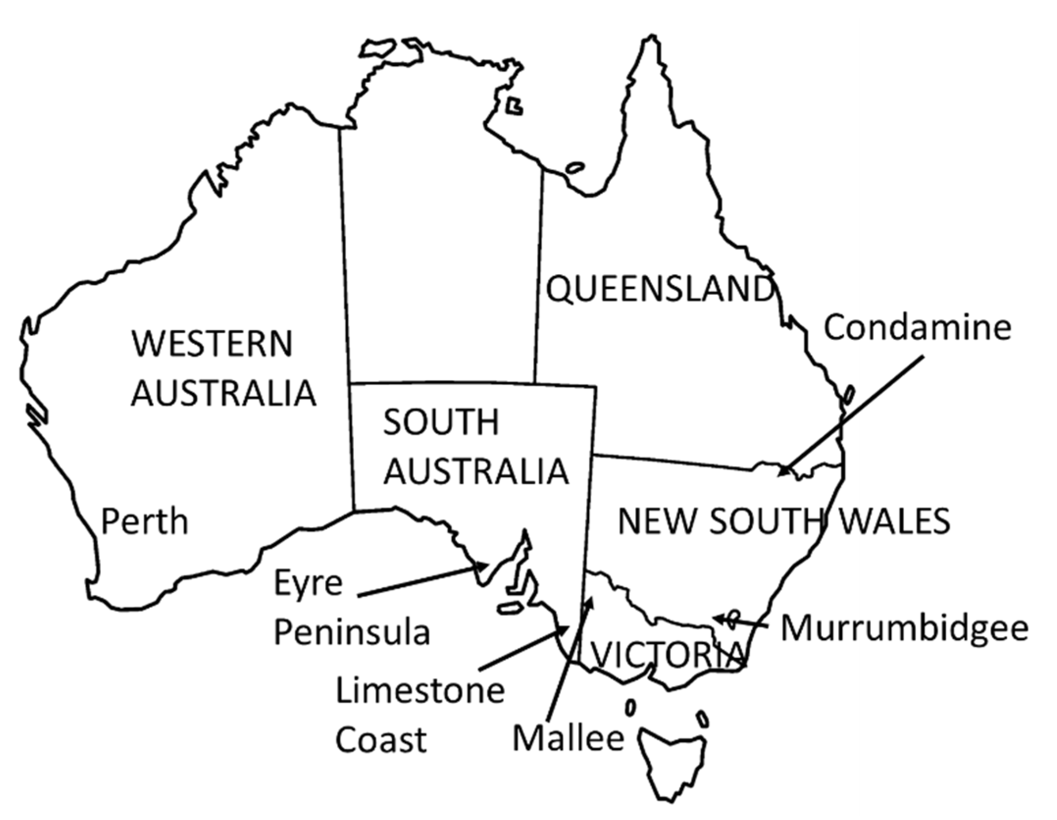
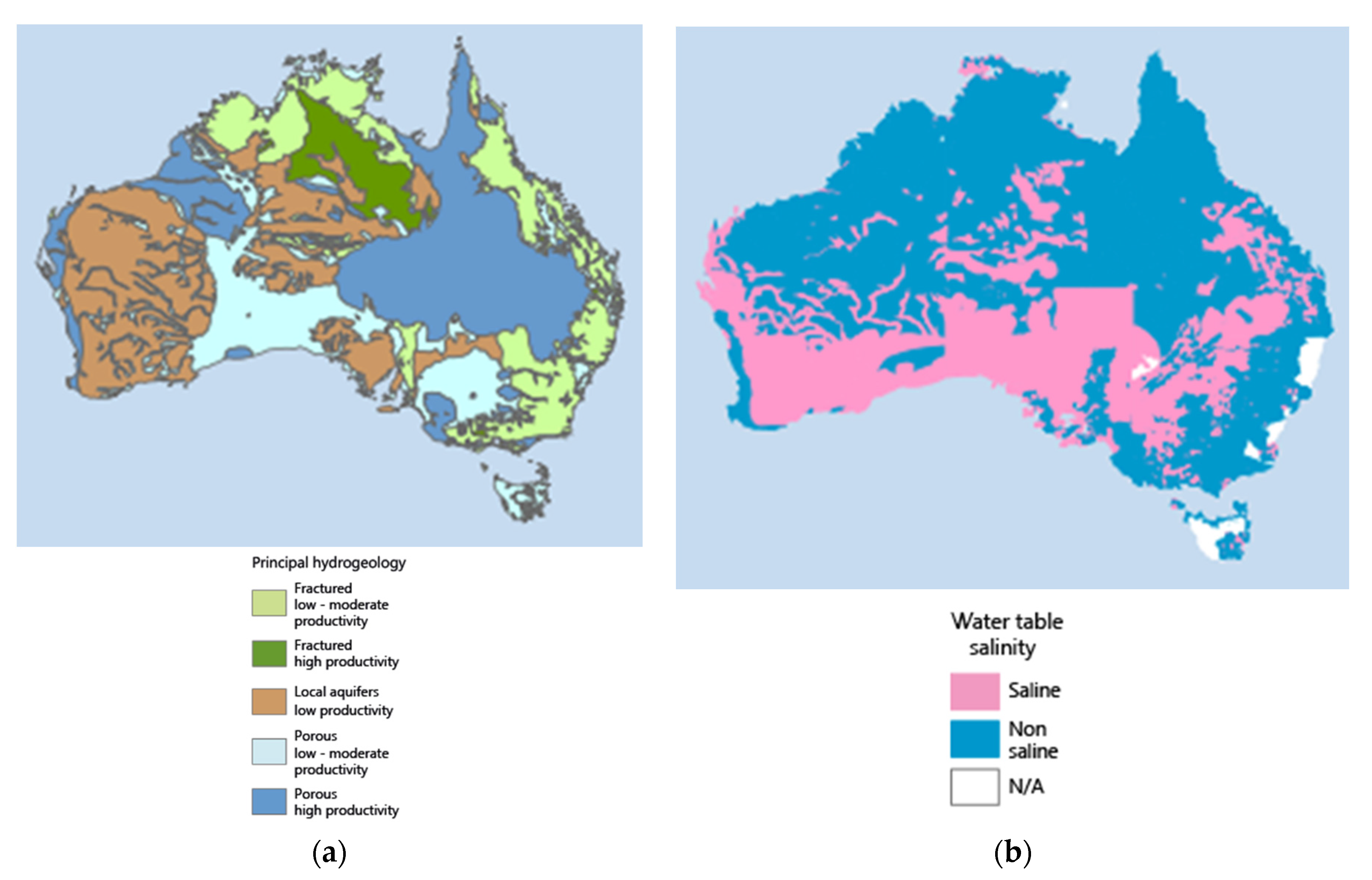
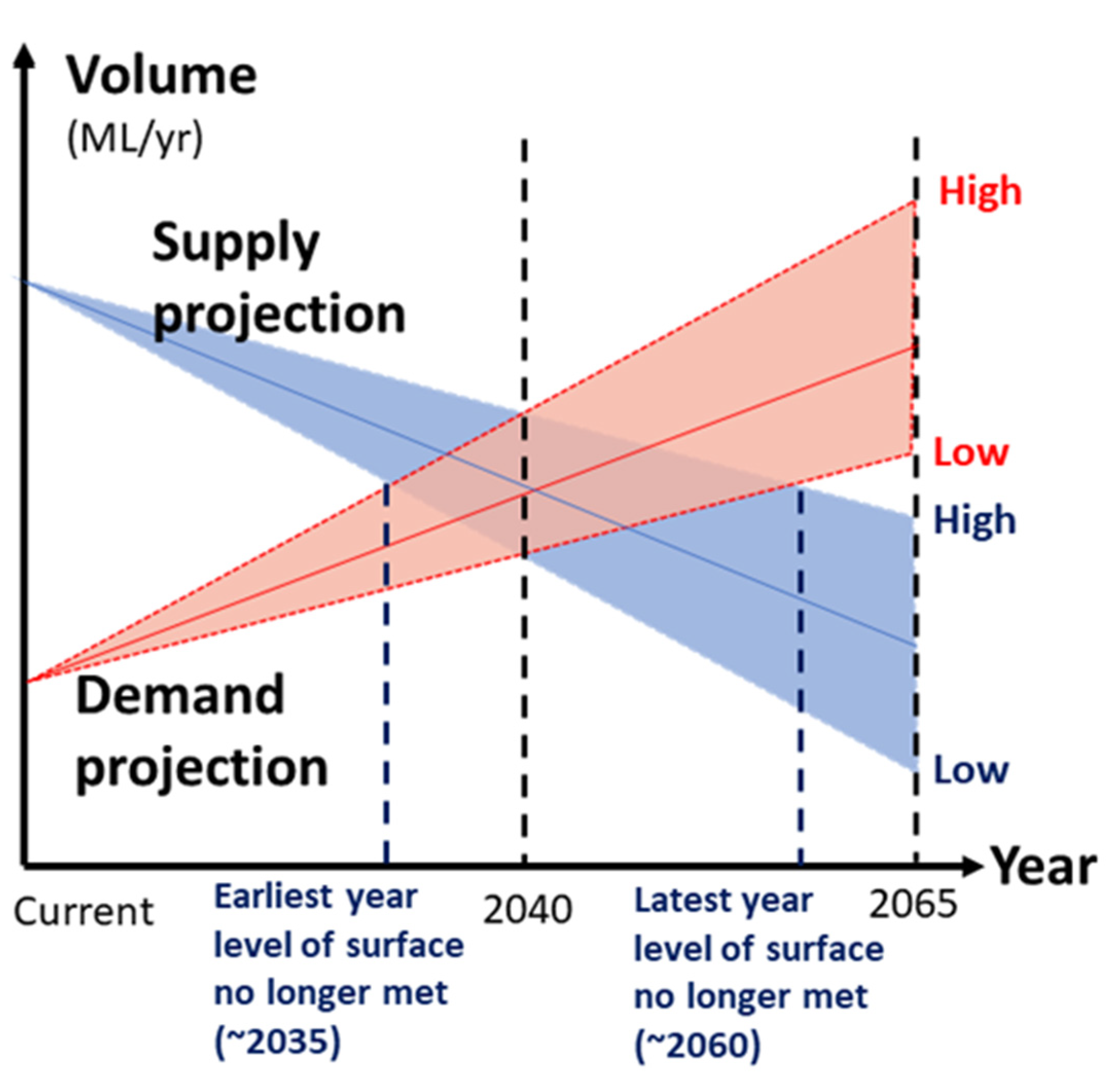
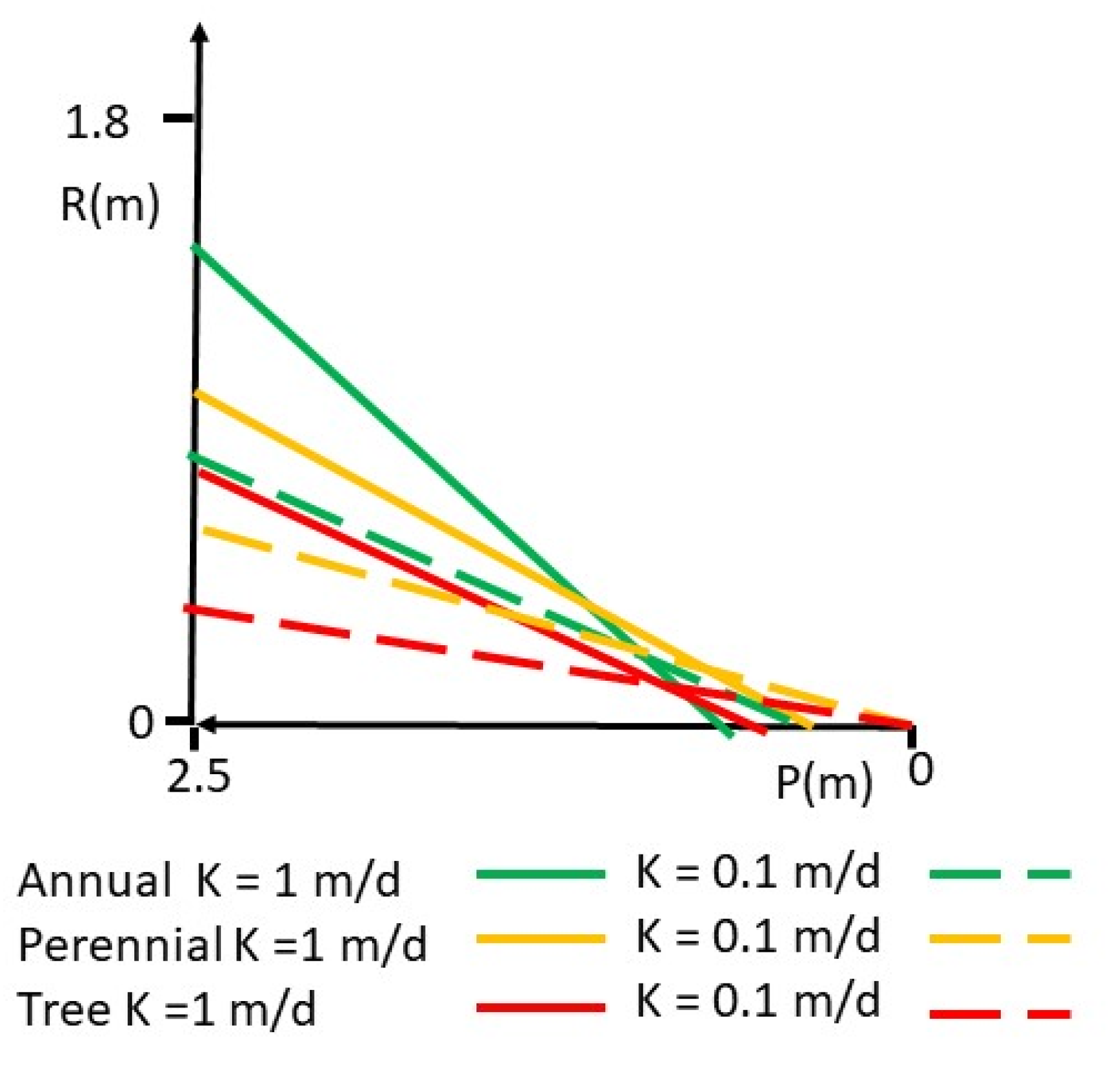
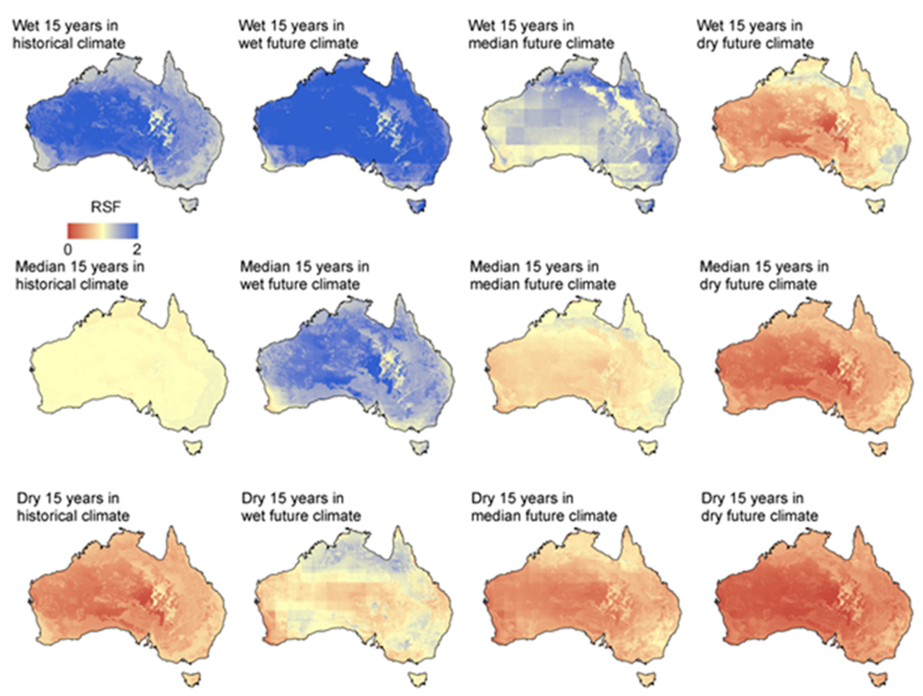
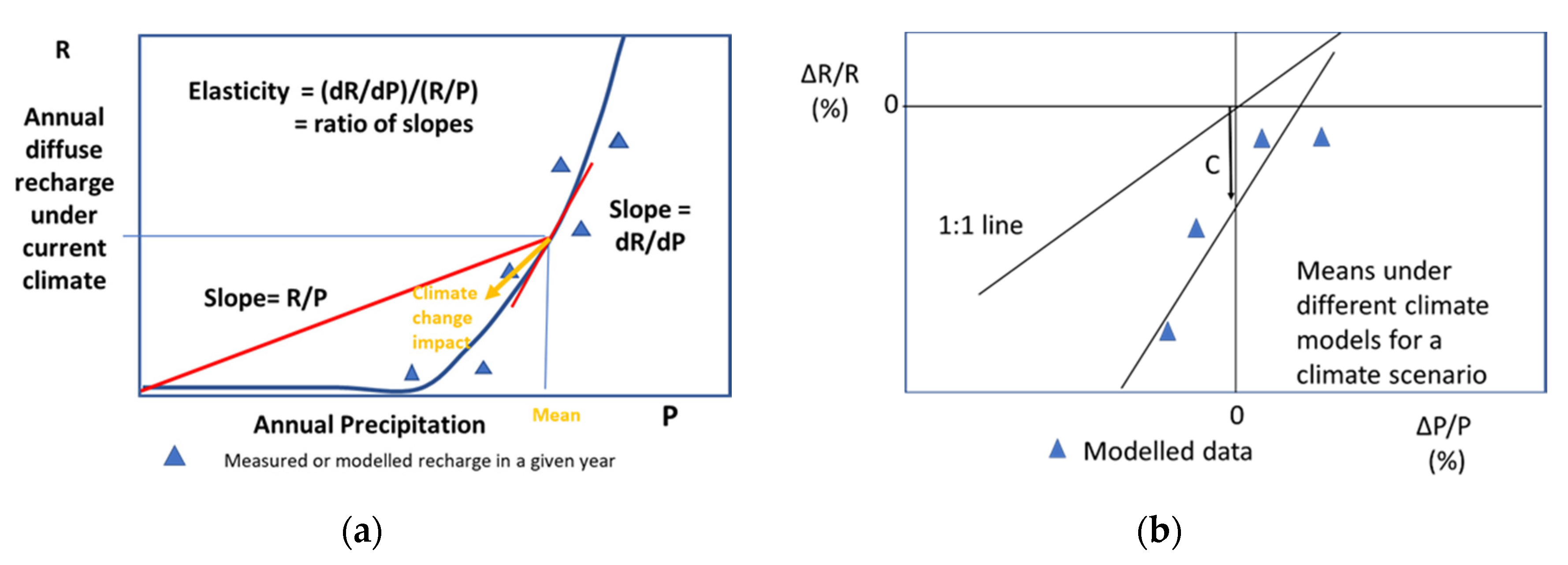
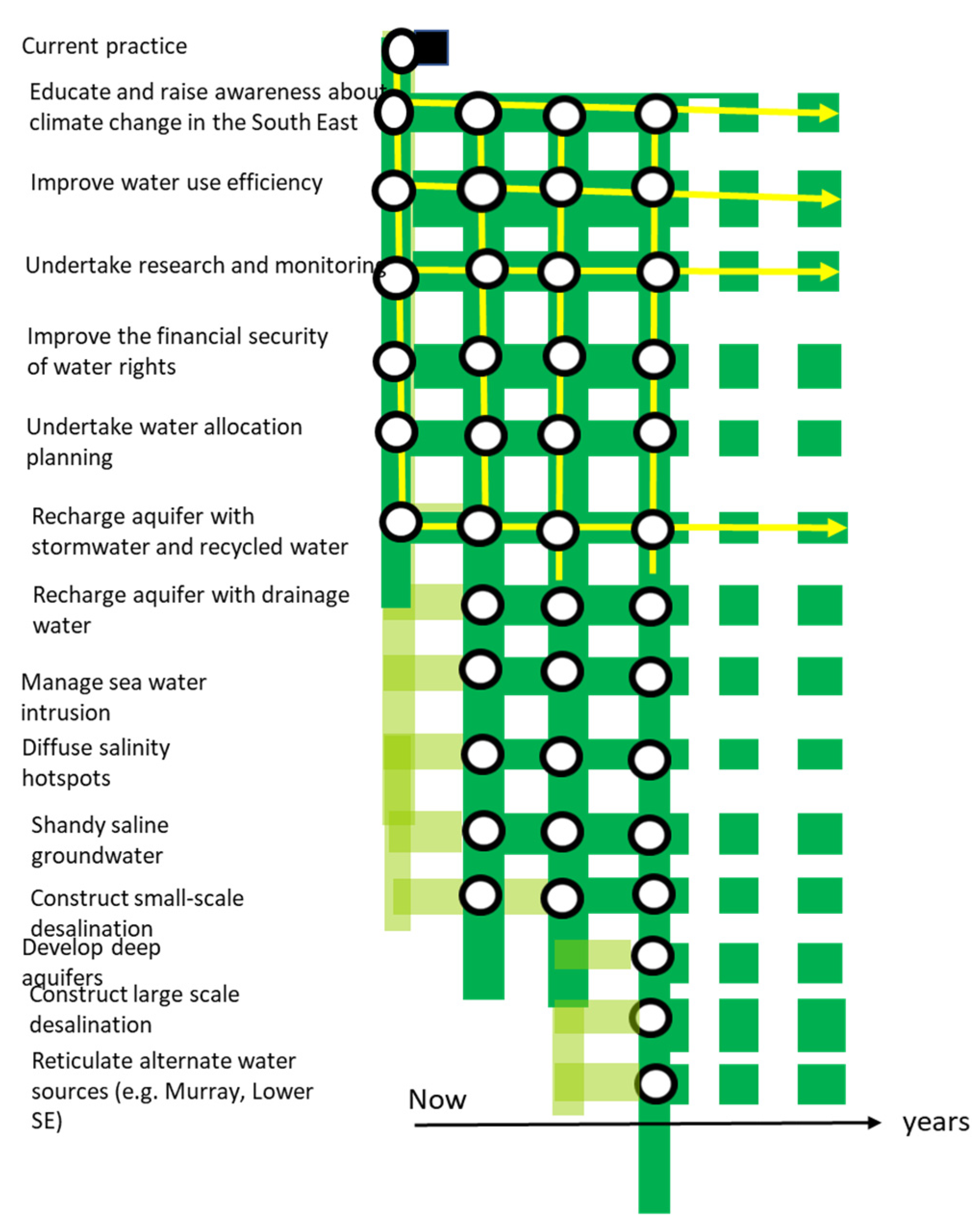
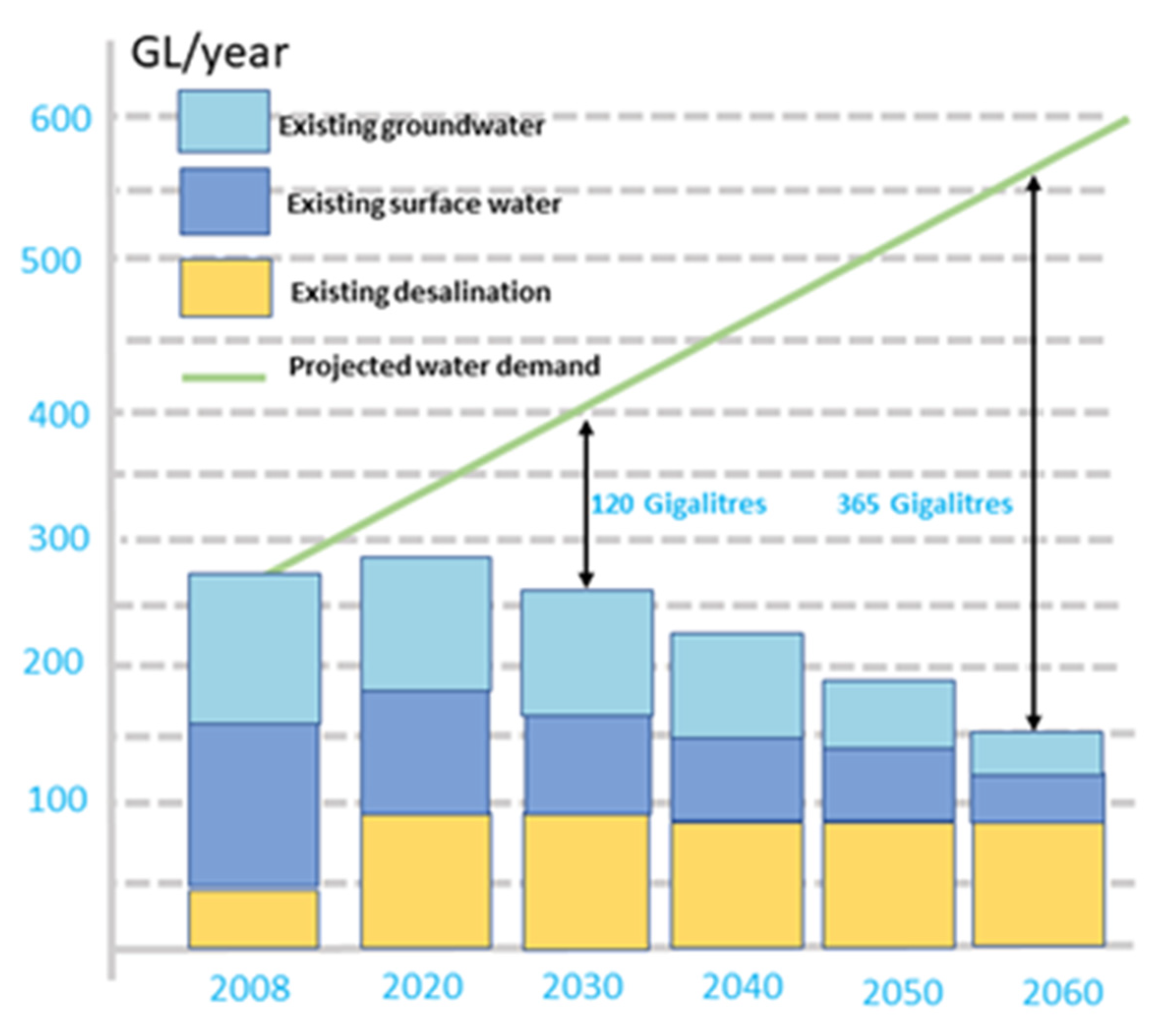
Table 1.
Modelling outputs from a range of studies across Australia. Results are shown for Perth [75]; Southern PWA (Eyre Peninsula) [77]; Mallee [61]; Murrumbidgee (NSW); and Condamine (QLD) [72].
| Region | State | Scenario | |||
|---|---|---|---|---|---|
| Year | Wet (%) | Med (%) | Dry (%) | ||
| Mallee | VIC | 2040 | 10.5 | −14.1 | −60.5 |
| Southern Basins PWA | SA | 2030 | −5 | −11 | −28 |
| 2050 | −8 | −21 | −48 | ||
| Murrumbidgee | NSW | 2020–39 | −8 | ||
| Condamine | QLD | 2020–39 | +5.0 | ||
| Central Perth | WA | 2030 | −2 | −18 | −35 |
Publisher’s Note: MDPI stays neutral with regard to jurisdictional claims in published maps and institutional affiliations. |
© 2021 by the authors. Licensee MDPI, Basel, Switzerland. This article is an open access article distributed under the terms and conditions of the Creative Commons Attribution (CC BY) license (https://creativecommons.org/licenses/by/4.0/).
Share and Cite
MDPI and ACS Style
Walker, G.R.; Crosbie, R.S.; Chiew, F.H.S.; Peeters, L.; Evans, R. Groundwater Impacts and Management under a Drying Climate in Southern Australia. Water 2021, 13, 3588. https://doi.org/10.3390/w13243588
AMA Style
Walker GR, Crosbie RS, Chiew FHS, Peeters L, Evans R. Groundwater Impacts and Management under a Drying Climate in Southern Australia. Water. 2021; 13(24):3588. https://doi.org/10.3390/w13243588
Chicago/Turabian StyleWalker, Glen R., Russell S. Crosbie, Francis H. S. Chiew, Luk Peeters, and Rick Evans. 2021. "Groundwater Impacts and Management under a Drying Climate in Southern Australia" Water 13, no. 24: 3588. https://doi.org/10.3390/w13243588
Note that from the first issue of 2016, this journal uses article numbers instead of page numbers. See further details here.