1. Introduction
The change of river regime is the result of the interaction between water and sediment conditions and riverbed boundary [
1,
2]. Water flows shape the channels, and the channels restrict water flows. Different conditions of water and sediment make it possible to create different forms of channel and gradients, and the change in riverbed boundary in turn affects the capability of channels to discharge floods and transport sediment, which eventually adjust and change river regimes [
3]. Due to the different combinations of water and sediment conditions (the amount and process of water and sediment entering the downstream in a given period of time), riverbed boundary (i.e., plane shape, section shape, longitudinal gradient, riverbed material composition and anti-scourability, beach trough height difference, etc.) and engineering boundary (i.e., project length, layout form, spacing, etc.), which caused the different regime for the same reach at different periods. Therefore, the riverbed evolves in different forms [
4]. Taking the Yellow River for example, its unique condition of water and sediment (such as less water and more sediment, temporal and spatial uneven distribution of water and sediment and different sources of water and sediment) is necessary for the formation and maintenance of its wandering reach, and the channel boundary provides space for the evolution and development of its river regime, which affects the change and intensity of the river regime. Favorable conditions of water and sediment (i.e., the year with abundant water and little sediment) only when combining with the help from the river regulation projects, could promote the favorable development of the river regime, otherwise it is likely that favorable conditions of water and sediment alone could not achieve obvious or any effects at all, leaving the river regime wide, shallow and scattered instead, which is not conducive to flood discharge and sediment transport [
3]. In recent years, the abnormal climate change, be it globally or regionally, has led to changing precipitation distribution in the Yellow River Basin [
5,
6,
7,
8,
9,
10]. From 1951 to 2018, the annual average temperature of the whole basin increased by 1.39 °C, while the regional average annual precipitation decreased by 10 mm. That is not a contradiction. Specifically, the annual precipitation in the upper reaches of the Yellow River has an obvious increasing trend, while the middle and lower reaches have an obvious decreasing trend, that is to say, the extreme precipitation process in the Yellow River Basin tends to increase (such as the 7.20 rainstorm in Zhengzhou in 2021) [
11]. All these would adversely affect the inter-annual and intra-annual distribution of runoff and sediment of the Yellow River [
12], and pose a great threat to the flood control in the lower Yellow River (for example, the autumn flood of the Yellow River in 2021 caused by extreme precipitation is the most severe flood control situation in the Yellow River Basin in recent decades).
In order to reveal the effect of discharge on the evolution characteristics of river regime, Jing H. and Zhong D.Y. et al. [
13] carried out physical model tests on dynamic riverbeds under different flow levels, and the results showed that there was still the possibility of lateral swings in the wandering reach under medium and small flow, and with the increase of discharge, the mainstream bending coefficient decreases gradually, and the channel shape gradually develops straight. Wang Q et al. [
14], by analyzing the prototype and flood forecast model test in the lower Yellow River in 2017, systematically studied the changing characteristics and patterns of the river regime in four malformed wandering reaches of the lower Yellow River under different level of flows, and proposed that river dredging, a sediment resource utilization and river regulation project could be integrated to stabilize the river regime. Jiang E H et al. [
15,
16] through a large number of model tests, established the index system and outflow distance formula between engineering outflow distance and flow, engineering bending radius, the length of projects next to river as well as inflow angle under small and medium flows, and the outcome of this study has been applied to the further wandering channel regulation scheme in the lower Yellow River. Some scholars [
3,
17] have analyzed the impacts of changing of water and sediment conditions on the evolution of river regimes, and it is qualitatively verified that when the boundary of river regulation project does not change significantly, if the dynamic processes of water and sediment entering the downstream are different, and the characteristics of river regime evolution in wandering reach are also different. It also showed that under the long-term effects of discharge of clear water or low sediment-laden flow, the river regime of wandering channels in the lower Yellow River experienced significant adjustment [
18,
19], such as enlarged river width, increased river island, scattered river regime, prominent abnormal river bend, even the site where the main flow is close to the project moves downwards and is away from river for the many river regulation projects [
20,
21]. Under the action of flow, the evolution of river morphology always lags behind the change of water and sediment conditions. The lag response model describes the response law of channel morphology to the change of discharge and sediment concentration, and then reflects the lag change of river bed evolution to water and sediment conditions [
22,
23,
24,
25]. The change of water and sediment conditions, especially the decrease of incoming water, will cause adverse river regimes such as abnormal bend and the Heng River, which has a great threat to river flood control [
26,
27]. Yuan et al. [
28] proposed a quick analysis of the silt sediment, and the trends of fluvial facies variations in the small-scale river reaches, but the deficiency is only for a single water and sediment conditions. Wang et al. [
29] analyzed the adjustment of the main-channel geometry in the lower Yellow River before and after the operation of the Xiaolangdi Reservoir; the research shows that the cross-sectional geomorphic coefficient is mainly related to discharge and suspended sediment concentration, and the correlation between cross-sectional geomorphic coefficient and discharge and suspended sediment concentration is obviously different in different river sections. Xie et al. [
30] combined the morphological indices extracted from the remote sensing images with field hydrological and geomorphological measurements, and qualitatively analyzed the evolution of the channel morphology of the Yellow River over the last 60 years. The analysis identifies that the width of the wandering belt changes at the highest degree of correspondence with the width/depth ratio of the main channel and the variations of both are related most closely to the average flow discharge and then to sediment concentration during the flood seasons.
The above research shows that most researchers analyzed the evolution of riverbed morphology from a macro perspective, and carried out a large number of qualitative descriptions of the impact of the change of water and sediment conditions on river regime evolution, while the quantitative research of water and sediment conditions on river regime evolution is rarely involved, and this research is very important for the flood control safety of wandering rivers with large variation of water and sediment conditions and unstable river regime. In this paper, the evolution of the river regime under different incoming water and sediment conditions by model tests is analyzed, the upward or downward moving distance of main stream zone of wandering reach in the lower Yellow River with a stable river regime by using the prototype measured data is calculated, the influences of water and sediment conditions on the upward or downward moving distance of main stream zone is quantitatively analyzed, and eventually a quantitative relationship between them is established. The study can provide some reference for hydrological workers, and quantitatively estimate the approximate trend of river regime according to the possible inflow and sediment conditions, which provides a certain scientific basis for river regime stability and river flood control early warning, and provides a certain method reference for quantitative study of river regime evolution of other rivers at home and abroad.
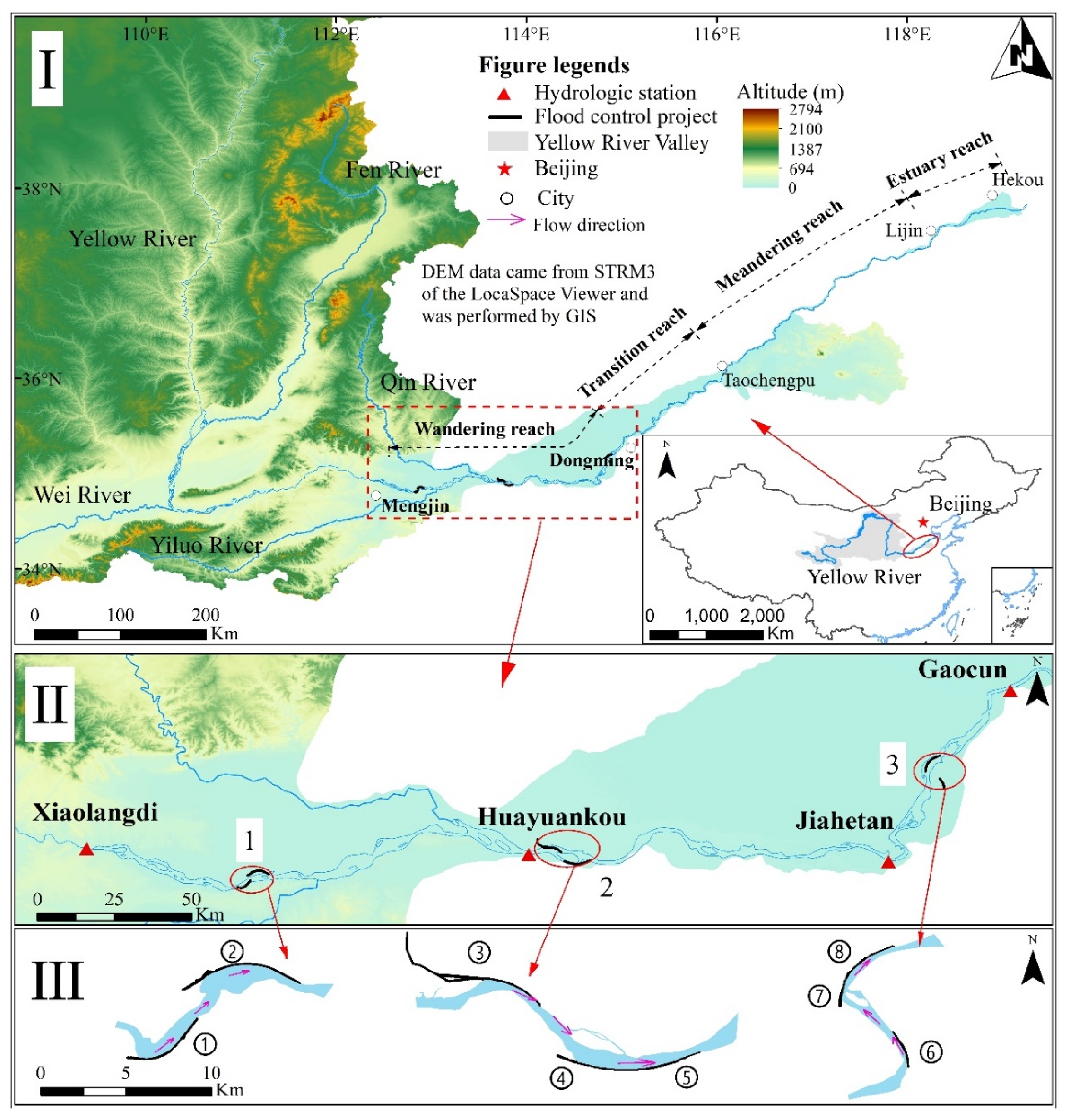
2. Study Area
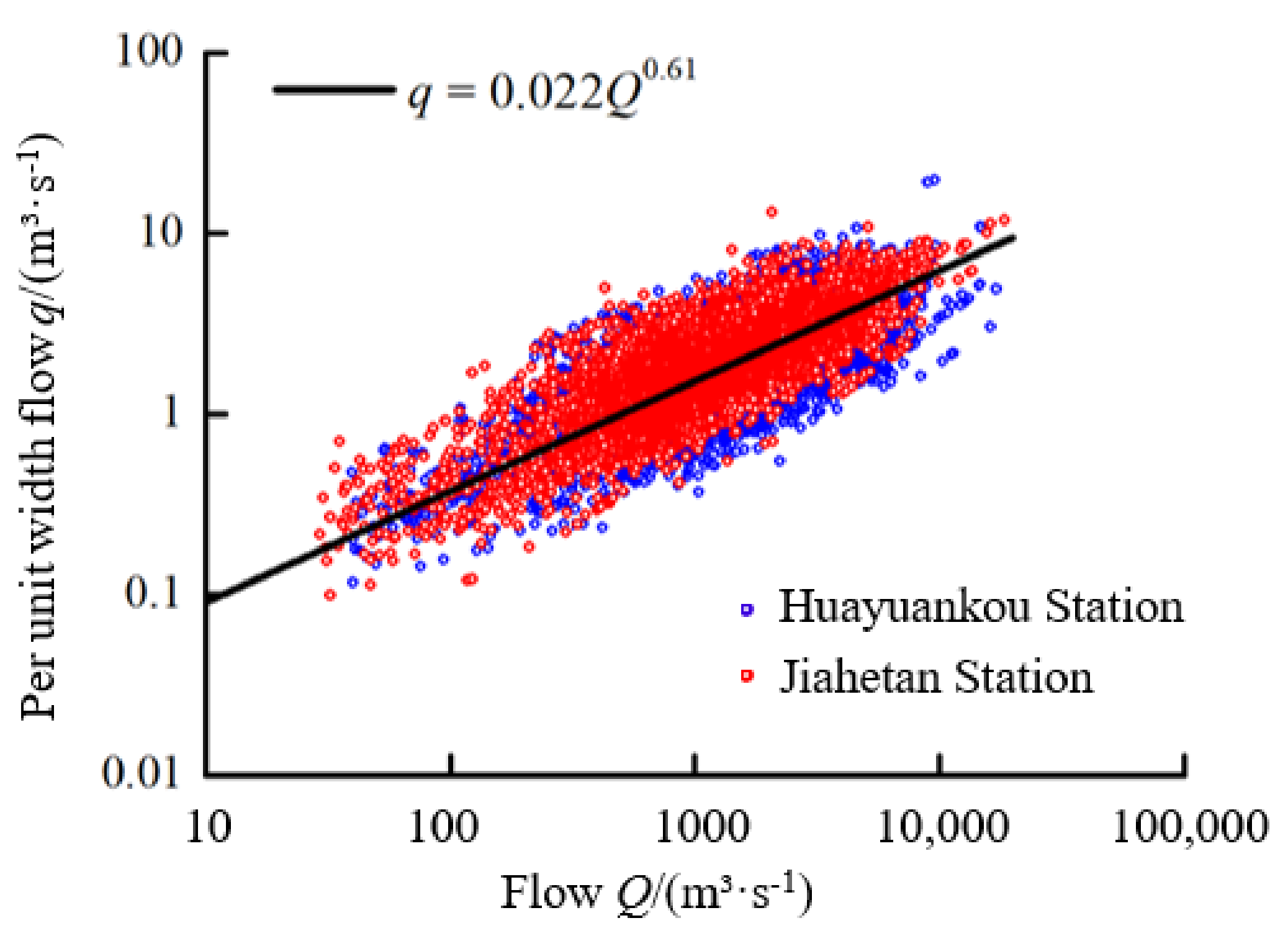
Wandering rivers in nature widely exist all over the world and the lower Yellow River is a typical one, especially its wandering reach, which is the top priority of the Yellow River harnessing. The wandering reach in the lower Yellow River starts from Baihe Town, Mengjin County, Henan Province, and ends in Gaocun Town, Dongming County, Shandong Province. It features a wide and shallow riverbed, drastic mainstream swing, rapid scouring-silting variation of river regime and densely covered sandbanks. The total length of the river reach is 299 km, with a longitudinal ratio of 0.172–0.265‰, spacing of levee of 10 km, maximum river width of [4 km and channel width of 3–5 km [
31]. With a small channel elevation difference (about 0.26–2.11 m) [
32], straight shape, and an average tortuous coefficient of 1.15 [
33], the plane of the channel looks like nodes of a lotus rhizome [
34]. There are three hydrological stations, respectively, located in Huayuankou, Jiahetan and Gaocun. The measured data show that the changing of water and sediment conditions will lead to the upward or downward moving of main stream zone at the site where the main flow is close to the project. In order to study the quantitative relationship between water and sediment conditions and the upward or downward moving distance of main stream zone, the wandering reach projects in the lower Yellow River with a stable river regime were selected in this paper, and the distance change of the site where the main flow is close to the project of the corresponding next project was studied. According to this principle, the Zhaogou-Huagong project (Huayuanzhen-Peiyu reach), Shuangjing-Madu downward extension project (Huayuankou-Laitongzhai reach), Xindianji-Zhouying control project (Youfangzhai-Yangxiaozhai reach) were selected in the wandering reach of the lower Yellow River, and the change of the site where the main flow is close to the project in different periods was counted (
Figure 1).
4. Results and Discussion
4.1. Summary of Model Test Results
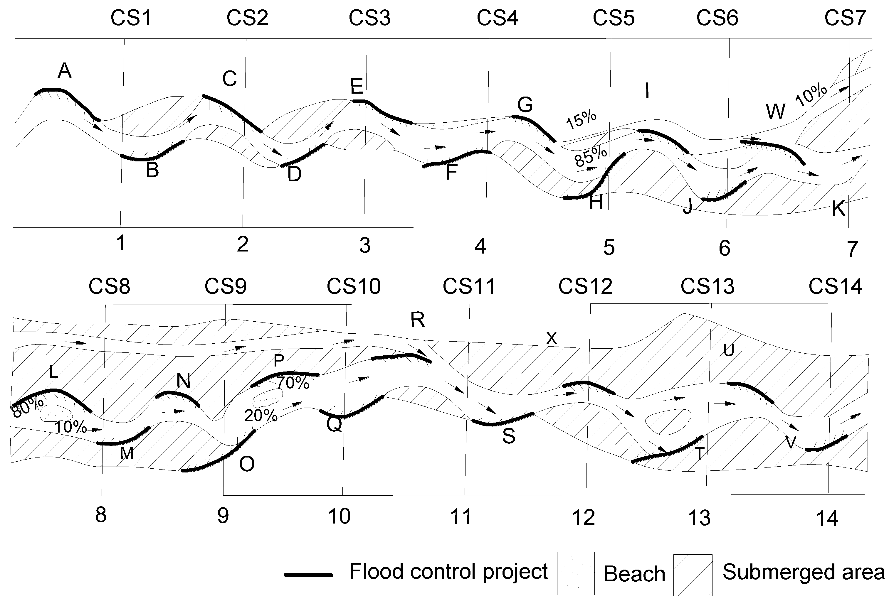
(1) Simulation of normal water and high sediment (group N1). The flow rate was set at 230 mL/s, total length of the project at 15 m (about 88% of the total river length), and imported sediment content at 13.2 kg/m
3 to simulate the river regime change of reach in the lower Yellow River under normal water and high sediment. At this time, the imported sediment content significantly exceeded the flow sediment carrying capacity of the model, indicating that the flow of the model was ultra-saturated. Therefore, a large amount of sediment was silted in the main channel, and the riverbed was raised, causing the channel elevation difference to be significantly reduced, and the channel to shrink. The overflow capacity was then greatly reduced, and the overbank water volume gradually increased. Especially, after more and more sediment was silted in the main channel, the flow delivery capacity became ineffective while the overbank water volume increased sharply, which led to a large number of projects submerged by overbank water. A scouring ditch was formed under the project G, of which the overflow accounted for 15% of the total flow, and it is likely that the ditch will form a new main stream. However, due to the high project density, the mainstream was still under control of the project in the main channel. For the channel, as the buckling factor decreased to about 1.1 and the width increased, the sand beach was already exposed, and the stability decreased significantly (
Figure 3).
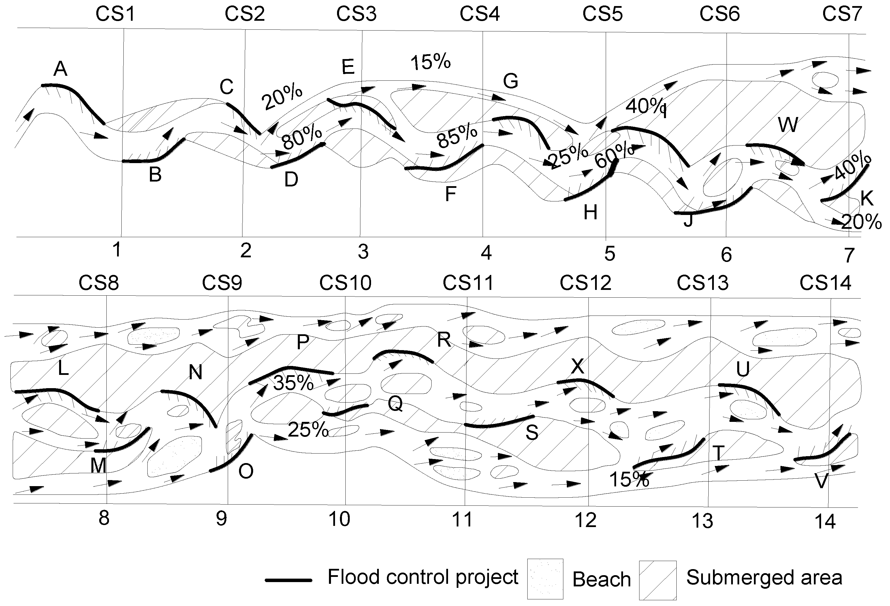
(2) Simulation of large water and low sediment (group N2) on the basis of the channel form shaped by group N1. The discharge flow was increased to 290 mL/s and the sediment content was reduced to 3.0 kg/ m3, and group N2 test was started for simulating the river regime when considering large water and little sediment after serious siltation and shrinkage of the channel.
Due to the low flood discharge capacity of the channel, the deep channel cannot be formed in a short time despite little sediment in the flood, resulting in overbank flood. As the water discharge duration increased, a scouring ditch was also formed below the import project C, with a split ratio of about 20%, which then flowed downstream and joined the old scouring ditch under the G project to form a new branch river. Moreover, as the flow path flowing into the main channel was gradually silted, the new channel continued to grow, with a split ratio reaching 40%. The river island in the new channel was exposed and densely covered with sand beach. A scouring ditch was also formed in the sand beach at the right bank. The flow of the original channel dropped to less than half of the total flow and many sandbanks were exposed. The project lost the effective control of river regime after 6 h of water release, and the stability of the model river was difficult to be restored in a short time (
Figure 4).
Therefore, for a relatively stable wandering channel under finite boundary control, its stability will change when the upstream incoming water and sediment conditions changed. In the case of high sediment-laden flood, especially with low-volume water carrying high-volume sediment, the main channel became silted and shrank, which will weaken the control effect of the project on the river regime. In case of floodplain flood, the scouring of floodplain flood may form a new river.
4.2. Quantitative Relationship between the Upward or Downward Moving Distance of Main Stream Zone and the Dynamic Changes of Water and Sediment Conditions
4.2.1. Quantitative Relationship with the Changes of Water and Sediment Conditions
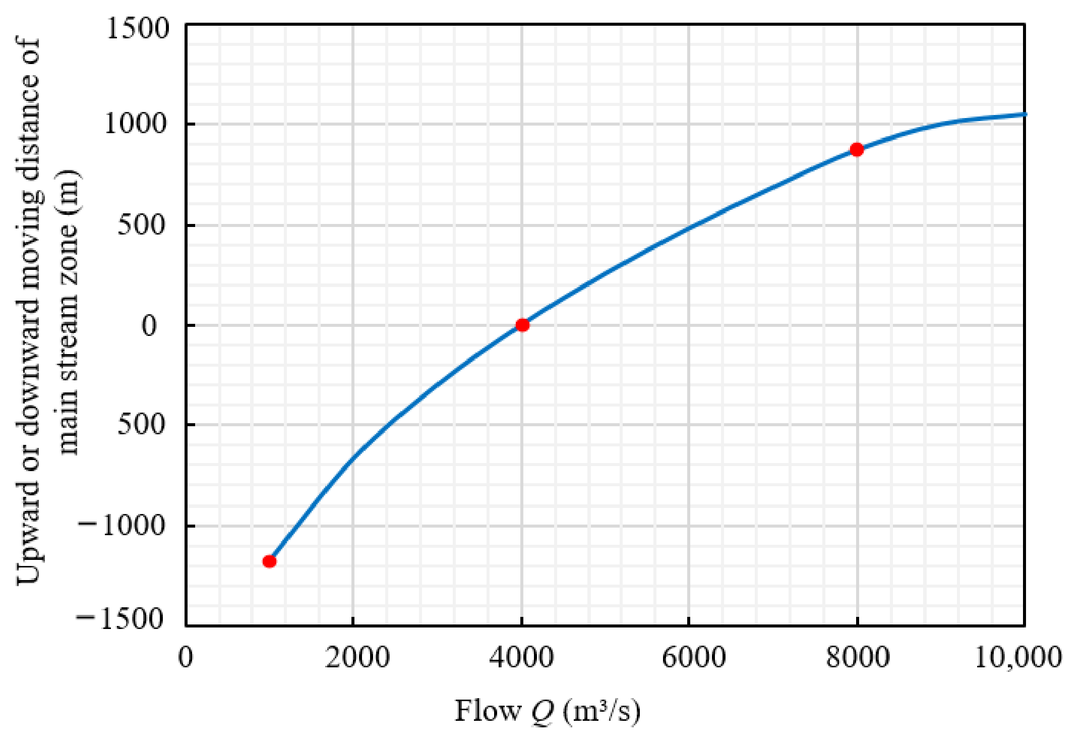
As the water and sediment conditions changed, the upward movement or downward movement of the site where the main flow is close to the project was mainly caused by different river bend spans being adapted to different flows. At present, the flow of river regulation projects in the lower Yellow River is set to 4000 m
3/s. In order to correspond to the reach with a stable outflow selected in this paper, the upward or downward moving distances of the site where the main flow is close to the project in Huayuanzhen-Yangxiaozhai reach at different flows were calculated by Equations (8) and (9) (
Table 2 and
Figure 5).
Table 2.
Calculated results of the upward or downward moving distances of main stream zone at Huayuanzhen-Yangxiaozhai reach.
Table 2.
Calculated results of the upward or downward moving distances of main stream zone at Huayuanzhen-Yangxiaozhai reach.
| Downstream Reach | Gradient (‰) | Medium Diameter (mm) | Flow (m3/s) | River Bend Span (m) | “Upward− or Downward + Moving Distance” (m) |
|---|
| Huayuanzhen-Yangxiaozhai reach | 0.25 | 0.1 | 1000 | 3277 | −1170 |
| 2000 | 4294 | −666 |
| 3000 | 5029 | −299 |
| 4000 | 5626 | 0 |
| 5000 | 6138 | 256 |
| 6000 | 6590 | 482 |
| 7000 | 6999 | 686 |
| 8000 | 7373 | 870 |
| 9000 | 7719 | 1046 |
| 10,000 | 8043 | 1208 |
Figure 5.
Relationship between the flow and upward or downward moving distance of main stream zone.
Figure 5.
Relationship between the flow and upward or downward moving distance of main stream zone.
Thus, at the planned flow of 4000 m3/s, there was no obvious upward or downward movement of main stream zone. In the case of long-term small flow of 1000 m3/s, the site where the main flow is close to the project can be moved upwards about 1170 m; in the case of large flood of 8000 m3/s, the site where the main flow is close to the project can be move downwards about 870 m.
4.2.2. Quantitative Relationship with Channel Scouring and Silting Change
(1) The distance of the site where the main flow is close to the project changes with time.
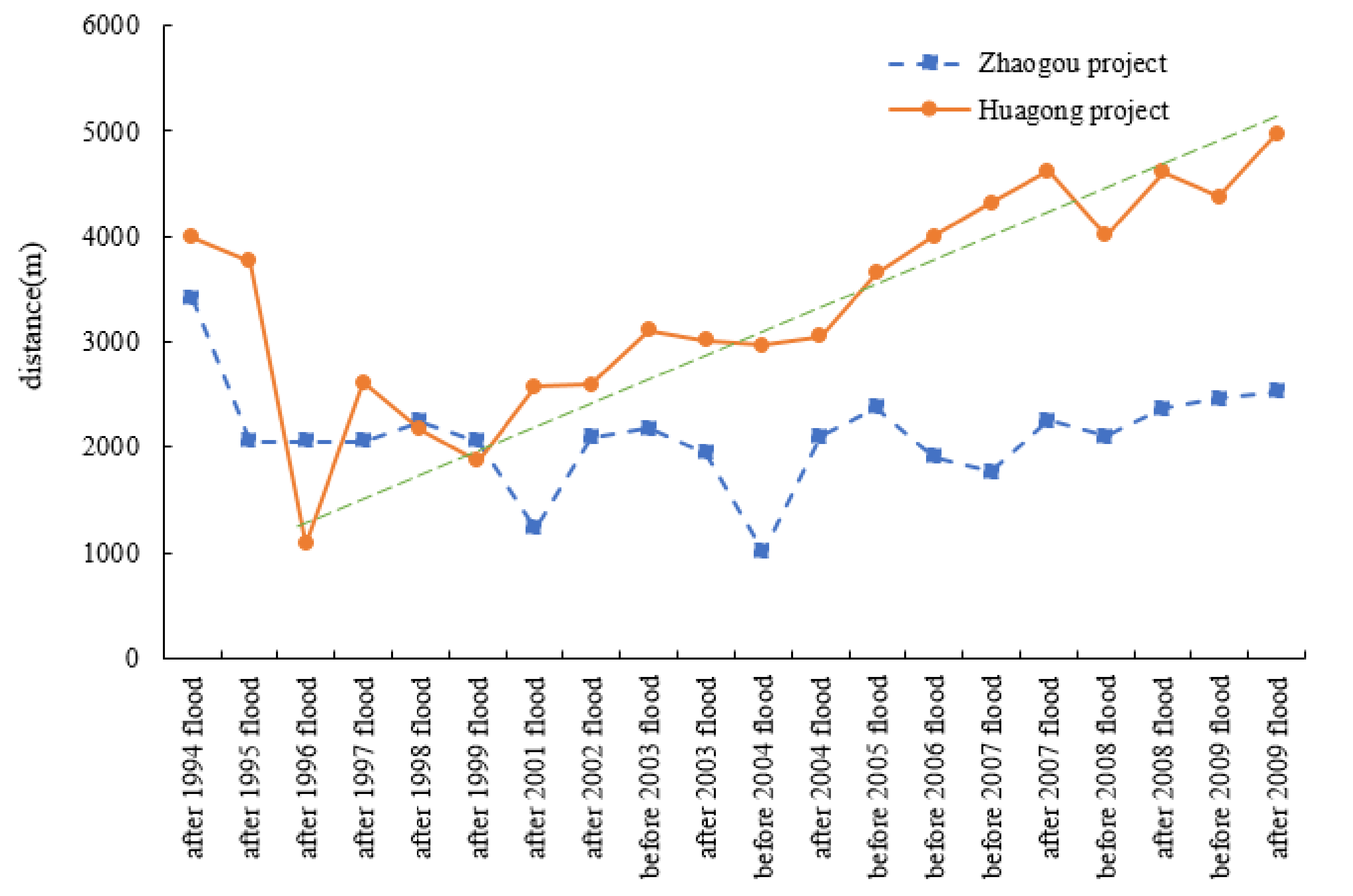
Generally speaking, the upward movement of the site where the main flow is close to the project may cause the upward or downward movement of the site where the main flow is close to the downstream project, and the changes are very complex. Taking the Zhaogou-Huagong project in the lower Yellow River as an example,
Figure 6 demonstrates the overall distance of the site where the main flow has been close to the project since the 1990s. It can be seen that the distance changes greatly in different years. Between 1999 and 2009, the distance that the main flow is close to the project at Zhaogou project remained stable, which means the outflow was stable; in the meantime, the distance that the main flow is close to the project of the downstream Huagong project increased.
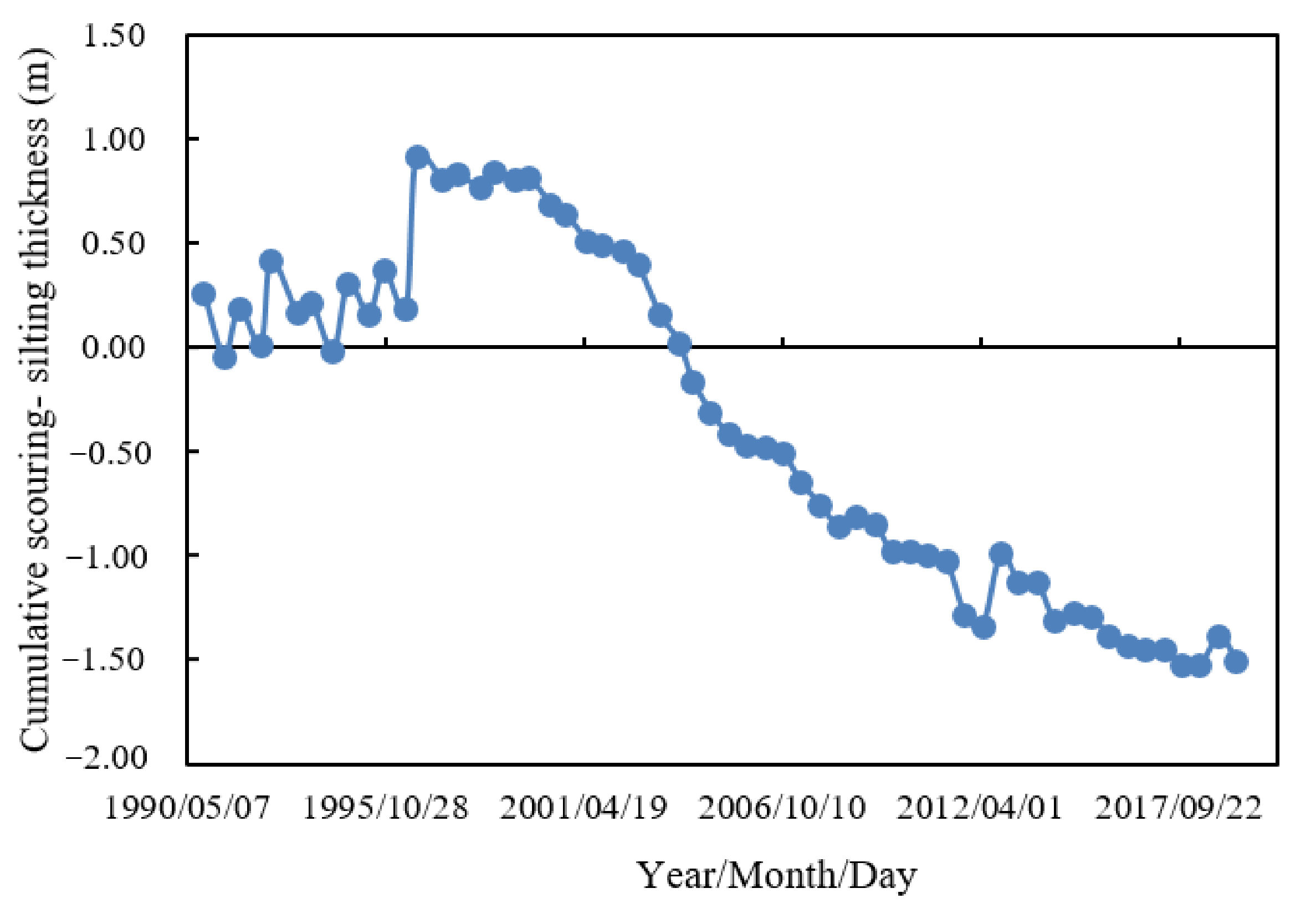
(2) The scouring-silting thickness changes with time.
Zhaogou-Huagong projects were located at Huayuanzhen-Peiyu reach, and the scouring and silting state of this river section between Zhaogou-Huagong projects from 1990 to 2019 was calculated by using the section method based on the large section topographic data of Huayuanzhen-Peiyu reach.
Figure 7 is the cumulative year-by-year scouring-silting quantity of Huayuanzhen-Peiyu reach (indicated by scouring-silting thickness). It can be seen that this reach was in a silting state before 2000, after which the channel began to cut down and was in a scouring state.
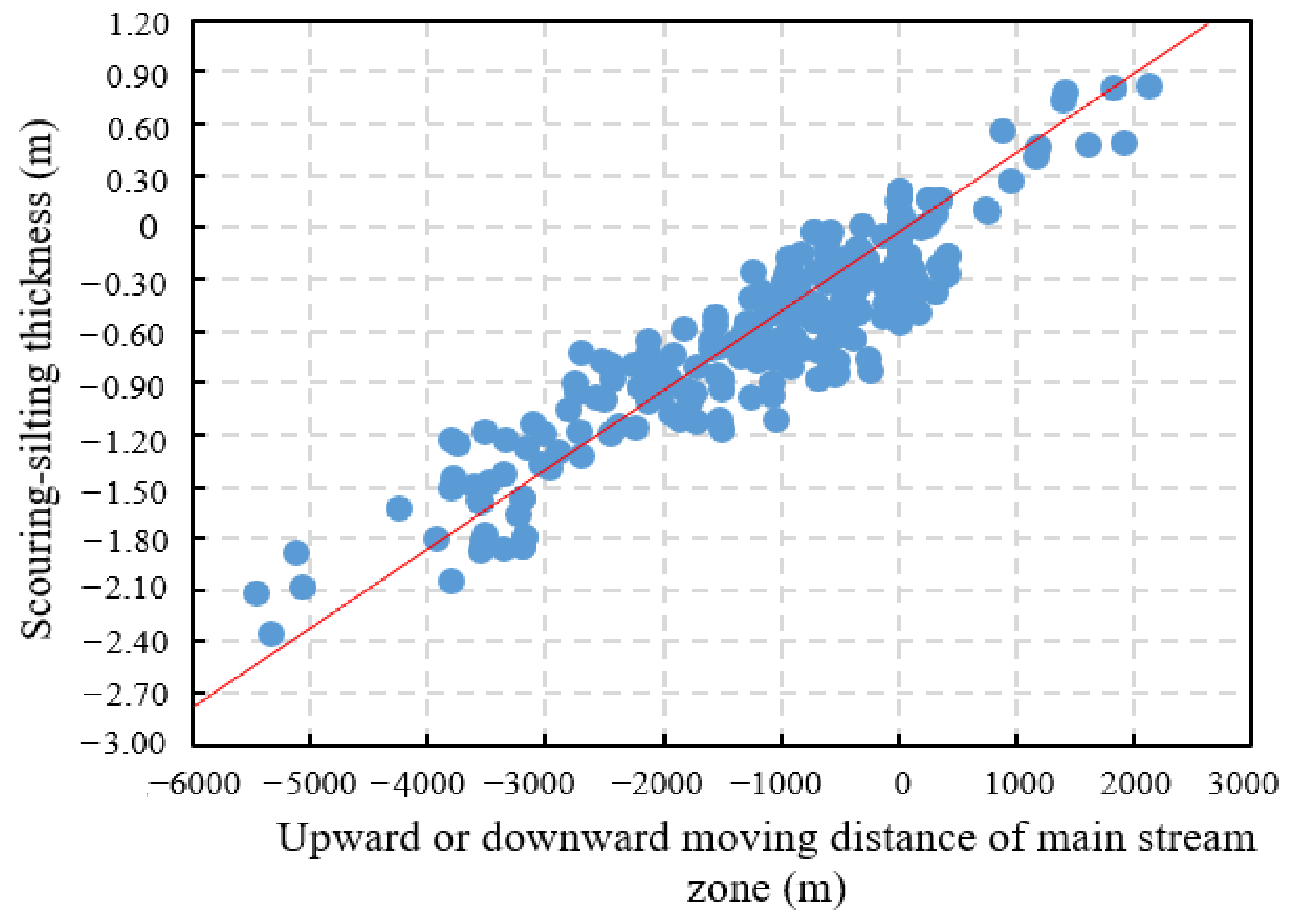
(3) The relationship between the upward or downward moving distance of main stream zone and the scouring-silting thickness of riverbed.
The relationships between the upward or downward moving distance of main stream zone and the scouring-silting thickness with time were analyzed. Based on the results, we established a quantitative relationship between the upward or downward moving distance of main stream zone and the scouring-silting thickness of Zhaogou-Huagong project, Shuangjing-Madu downward extension project and Xindianji-Zhouying project (
Figure 8). According to the results, there is a linear relationship over the origin between the upward or downward moving distance of main stream zone and the scouring-silting thickness. The upward movement of main stream zone when the channel is silted, and the upward movement of main stream zone when the channel is scoured. A regression analysis of multiple groups of data was made to determine the quantitative relationship between the upward or downward moving distance of the main stream zone and the scouring-silting quantity:
where Δ
x is the upward or downward moving distance of the main stream zone (m), Δ
z is the corresponding scouring-silting thickness of riverbed (m).
The riverbed deformation equation is ; as ; thus, the riverbed deformation is then directly related to the upward or downward moving distance of the main stream zone. When there was an equilibrium between scouring and silting (scouring-silting thickness was 0), the river regime was stable, and there was no upward movement and downward movement; when the silting thickness or scouring thickness was 0.9 m, the upward or downward moving distance of the main stream zone was 2000 m, separately. Thus, we established a quantitative relationship between the upward or downward moving distance of the main stream zone and the changes of water and sediment conditions. In other words, when the riverbed scouring thickness was about 0.39 m, the downward moving distance of the main stream zone was about 870 m, which was equivalent to the effect of medium flood of 8000 m3/s; when the riverbed silting thickness was about 0.53 m, the upward moving distance of the main stream zone was about 1170 m, which was equivalent to the effect of long-term small flow of 1000 m3/s.
Figure 8.
Relationship between the upward or downward moving distance of the main stream zone and the scouring or silting thickness.
Figure 8.
Relationship between the upward or downward moving distance of the main stream zone and the scouring or silting thickness.
4.3. Discussion
(1) The research shows that the upward or downward movement of the main stream zone is closely related to water and sediment conditions. Based on the physical model test, by changing the water and sediment conditions, the river regime evolution of wandering channels under the same river regulation project conditions can be obtained, and the influence of different water and sediment conditions on river regime can be qualitatively analyzed. This research result further clearly verifies the previous qualitative results; based on the measured water and sediment data, the relationship between discharge and river regime lifting and falling distance, as well as the relationship between river erosion and deposition and river regime lifting and falling are constructed, respectively, which provides a method to calculate the river regime lifting and falling distance and water and sediment conditions. This method calculates the influence of water and sediment conditions on river regime from a quantitative point of view, which is obviously innovative.
(2) The “bent under small flow, straight under large flow” phenomenon under natural conditions is demonstrated as “rise under small flow, fall under huge flow” in the river regulation project. This phenomenon can be explained by this study. In the case of small flow, the water changed its direction after becoming bent in the beach and scoured the downstream beach on the opposite bank. As the upstream beach was continuously scoured, the downstream beach also collapsed and retreated while the bending rate increased, forming the “bent under small flow” situation. After the river regulation project was constructed at the bend, the water flow formed a circulation flow here, resulting in siltation of beach on the opposite bank. Meanwhile, the water flow was separated, went upstream after being blocked by the building and scoured the beach bank with weak impulse resistance before the project above the beach that projects next to river, resulting in the “rise under small flow” condition. In the case of small flow, the increase in water momentum led to “straight under large flow”. After the construction of the project, a large number of turbulent vortices were formed near the project, which pushed off the water flow from the bend and gradually scoured the convex bank beach, causing the site that projects next to river of the project to move downwards and the “moving downward under large flow” situation to be formed. Therefore, to control of the stability of river regime, a long-enough inflow section will be required in case the river regime rose when the channel is silted, while a long-enough delivery section also will be necessary in case the river regime fell when the channel is scoured.
(3) Affected by the flow, the upward or downward movement of the main stream zone is represented by the creep of the river bend in the plane form of the river. During the small and medium flow period, due to the site where the main flow is close to the project, the concave bank moves upwards along the channel, the water flow becomes curved, and the circulation strength of the bend upstream became large, resulting in possible siltation in most areas of the convex bank; during the flood period, due to the site where the main flow is close to the project, the concave bank moves downwards along the channel, the water flow becomes straight, and the circulation strength of the bend upstream became small, and the silting of convex bank downstream increases gradually. For the whole channel, there are more opportunities for erosion in the downstream concave bank and more opportunities for silting in the downstream convex bank. Therefore, in the bend section, the concave bank is gradually scoured and retreated, and the convex bank is silted and extended forward year-by-year, which often caused the whole bend to move slowly downstream, i.e., river bend creep in terms of plane form.
(4) This study has a certain application scope. At present, this study only used the natural measured data of the wandering channel in the lower reaches of the Yellow River for calculation. Although the data are very rich, if other rivers at home and abroad want to use this method, calculation and verification are also necessary by using the data of other rivers, so as to make the method more reliable. Meanwhile, it should be explained that the relationship between the upward or downward moving distance of the main stream zone and the scouring-silting thickness of riverbed was in a general sense. The river regime mutation such as local malformed river bend was mainly affected by the uneven distribution of the cement layer of the riverbed.
5. Conclusions
(1) The qualitative influence of the water and sediment conditions on river regimes was analyzed by model tests. Under the same circumstances of river regulation projects, the changes of water and sediment conditions would significantly affect river regime evolution. Therefore, the stability of the riverbed would change when the upstream incoming water and sediment conditions change. In the case of high sediment-laden flood, especially small water carrying high sediment, the main channel became silted and shrank, which will weaken the control effect of the project on the river regime. In the case of overbank floods, a new river may be formed under the scouring.
(2) A quantitative relationship between the upward or downward moving distance of the main stream zone and the water and sediment conditions was established with the prototype measured data. The results showed that there was an obvious linear relationship between the upward or downward moving distance of the main stream zone and the water and sediment conditions, which directly affected the morphological evolution of the riverbed. In the case of long-term small flow running at 1000 m3/s or channel silting thickness of about 0.53 m, the upward moving distance of the site where the the main flow is close to the project was about 1170 m; in the case of large flood running at 8000 m3/s or channel scouring thickness of about 0.39 m, the downward moving distance of the site where the main flow is close to the project was about 870 m. Therefore, in order to maintain the stability of the river regime, a long-enough inflow section was required to respond to long-term small flows or channel silting, and a long-enough outflow section was also necessary to respond to large floods or channel scouring.


