Article

Wet Meadow Plant Communities of the Alliance Trifolion pallidi on the Southeastern Margin of the Pannonian Plain

1
Research Centre of the Slovenian Academy of Sciences and Arts, Institute of Biology, 1000 Ljubljana, Slovenia
2
School for Viticulture and Enology, University of Nova Gorica, 5000 Nova Gorica, Slovenia
3
Department of Biology and Ecology, Faculty of Science, University of Novi Sad, 21000 Novi Sad, Serbia
4
Department of Biology, Biotechnical Faculty, University of Ljubljana, 1000 Ljubljana, Slovenia
5
Faculty of Forestry, University of Zagreb, 10000 Zagreb, Croatia
*
Author to whom correspondence should be addressed.
Water 2021, 13(3), 381; https://doi.org/10.3390/w13030381
Submission received: 30 December 2020 / Revised: 23 January 2021 / Accepted: 26 January 2021 / Published: 1 February 2021
(This article belongs to the Special Issue Hydrology-Shaped Plant Communities: Diversity and Ecological Function)

Abstract

:
The article deals with wet meadow plant communities of the alliance Trifolion pallidi that appear on the periodically inundated or waterlogged sites on the riverside terraces or gentle slopes along watercourses. These plant communities are often endangered by inappropriate hydrological interventions or management practices. All available vegetation plots representing this vegetation type were collected, organized in a database, and numerically elaborated. This vegetation type appears in the southeastern part of the Pannonian Plain, which is still under the influence of the Mediterranean climate; its southern border is formed by southern outcrops of the Pannonian Plain and its northern border coincides with the influence of the Mediterranean climate (line Slavonsko Gorje-Fruška Gora-Vršačke Planine). Numerical analysis established four plant associations—Trifolio pallidi–Alopecuretum pratensis, Ventenato dubii–Trifolietum pallidi, Ranunculo strigulosi–Alopecuretum pratensis, and Ornithogalo pyramidale–Trifolietum pallidi. Each association was elaborated in detail: diagnostic plant species, nomenclature, geographical distribution, climatic and ecological conditions, and possible division into subassociations. Results are presented in a distribution map, figures resulting from numerical analysis, and a synoptic table. The hydrological gradient was found as the most important factor shaping the studied plant communities. The article also brings new field data on this vegetation type, which has not been sampled for decades and is in process of evaluation to be included as a special habitat type in the Habitat Directive.

1. Introduction

Wet meadows of Trifolion pallidi appear on clayey, mesotrophic to eutrophic soils on riverside terraces and gentle slopes along the rivers in the southeastern margin of the Pannonian Plain. Inundations of the sites during winter and spring are common, and the humidity of sites is often influenced by the high level of groundwater, which is frequently close to the surface. During the summer, the ground may dry up [1].
Hydrological factors such as seasonal floods and high water table in the soil significantly define the composition of plant communities exposed to such influences. The hydrological gradient has been generally accepted as the primary factor that determines the growth of different species and the structure of herbaceous wetland plant communities [2,3,4,5]. Water level fluctuation that is also characteristic of studied sites shapes the plant communities in different ways. The sensitivity to inundation and drying have both important roles in the distribution and abundance of species [6,7]. The sensitivity of plant species to water level fluctuations is reflected in their reduced growth and abundance [8,9].
Vegetation and ecology of the meadows on the southern margin of the Pannonian Plain were studied in relation to climatic gradient by Ilijanić [10]. He divided the wet meadow vegetation of northern Croatia into three groups. The most easterly group extends from the river Orljava eastwards and is characterized by a dry climate with low precipitation (600–800 mm). Dry periods are in April and from July to September, with an average monthly temperature of 22–23 °C and an absolute maximum in July over 40 °C. He also stated that other ecological conditions in northern Croatia are very similar; only climatic conditions are different, and this is reflected in the vegetation. He also reported that wet meadows from the area are more similar to those appearing along the rivers Sava and Morava in Serbia [11,12] than to meadows of western Croatia and established the western and northern boundaries of the elaborated vegetation.
Ilijanić [13] later classified wet meadows of the region within the alliance Trifolion pallidi, integrating it in the order Trifolio–Hordeetalia, which encompasses wet meadows under the influence of the Mediterranean climate in the eastern Mediterranean, namely, meadows of the alliances Trifolion resupinati, which occur in northern Macedonia and Molinio–Hordeion from the coastal region of Croatia. The order today also includes an alliance encompassing salty meadows in the northern Balkans (Trifolio–Ranunculion pedati) and wet meadows on karst poljes in the Apennines (Ranunculion velutini) [14]. There still exist some open questions. For instance, Purger [15] suggests the classification of the alliance Trifolio–Ranunculion pedati as a suballiance within the alliance Festucion pseudovinae of the class of salted steppe and steppic grasslands Festuco–Puccinellietea. There was also a discussion about the classification of the alliance Alopecurion utriculati [16], wet meadows distributed over the whole Balkan Peninsula. This problem was solved by Mucina and Theurillat in [14] by its lectotypification—they have selected the same association as a type of Alopecurion as of the alliance Molinio–Hordeion and in this way, Alopecurion became a homotypic synonym of Molinio–Hordeion.
A great part of wet meadows of Trifolion pallidi is (co)dominated by Alopecurus pratensis, a species of broad ecological amplitude and wide distribution range. It is a dominant species in many plant communities across Europe (e.g., [17,18,19]), which are assigned to various higher syntaxa due to different floristic compositions, reflecting different (macro) climatic and ecological conditions and their phytogeographic position.
In the wider Pannonian region, Alopecurus pratensis-dominated communities can be found in various habitats, in salted inundated meadows [20], saline steppic pastures [15], temporarily flooded and grazed pastures [21], and in wet meadows [22].
The Trifolion pallidi communities appear only on the southeastern margin of the Pannonian Plain. According to the numerical analysis of meadow vegetation along the southern margin of the Pannonian Plain, it was established that Trifolion pallidi communities form a distinct group of communities (alliance) appearing only in its southeastern margin [23], and they cannot be found in the central part of the Pannonian Plain [1,24]. This was confirmed also by recent numerical analysis of habitats on the European scale [25].
(Macro) climatic, phytogeographical, and ecological factors are often interdependent in terms of their influence on site conditions; e.g., in drier macroclimatic conditions, plant communities with a mesic character can establish in wet sites to compensate for the lack of precipitation. Alopecurus pratens is dominated meadows (Alopecurion/Deschampsion), widespread in west Croatia, under the increased influence of the drier continental climate toward the east (east Croatia, Serbia), thus retreat to locally wetter sites, building Trifolion pallidi communities [23].
Many vegetation types of meadows are included in the European Habitat Directive [26] and the Interpretation Manual of European Union Habitats [27]. The vegetation under consideration (wet meadows of Trifolion pallidi) has not yet been considered within the European Habitat Directive [26] but has been proposed for consideration in the accession process of Serbia [23].
The aim of the paper is to collect all available data about Trifolion pallidi communities and present the appearance of wet meadows of the alliance Trifolion pallidi on the southeastern margin of the Pannonian Plain. We tried to reveal the most important factors that enable the diversity of those meadows. We prepared an insight into its classification up to subassociation level taking into consideration also results of new synthetic works that have appeared recently. At the same time, we provided new field data on this habitat, which is under consideration within the European Habitat Directive [26].

2. Materials and Methods
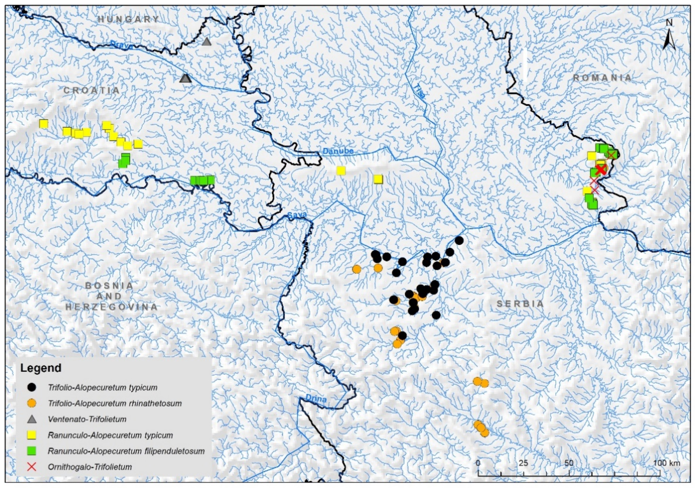
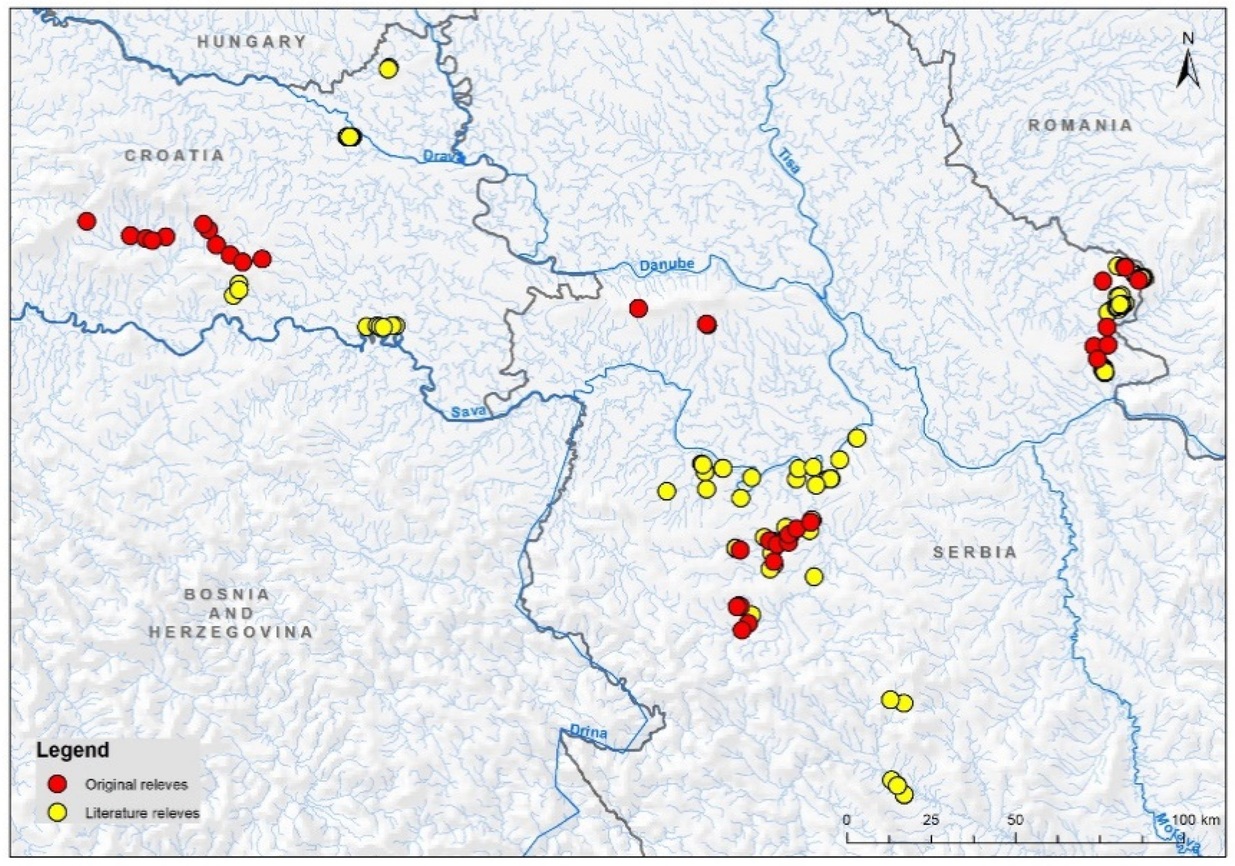
2.1. Study Area

The study area extends along the southeastern margin of the Pannonian Basin, encompassing eastern parts of Croatia and the northern part of Serbia (Figure 1). This area is under the influence of a moderate continental climate: a moderately warm and humid climate with warm summers [28,29]. The climatic data for three meteorological stations in the region are—Osijek mean annual temperature 11.0 °C and annual precipitation 655 mm; Novi Sad 10.9 °C and 647 mm and Valjevo 11.4 °C and 787 mm [28] (http://www.hidmet.gov.rs, accessed 31 October 2020).
Deciduous forests dominated by Hungarian oak (Quercus frainetto) appear in the area [30]. In the west, the area of research corresponds to the western localities of Hungarian oak in Slavonia (Kutjevo) [31]. In the north, the area includes a major part of Vojvodina. This area is still influenced by the Mediterranean climate, which arrives from the south (Figure 1) along rivers (e.g., Morava) [32]. The southern boundary corresponds to the geomorphological border of the Pannonian Plain [33], which corresponds to the phytogeographic border of the Pannonian Plain toward the Illyrian region proposed [34] and the border of the central European region toward the Mediterranean region [35].

2.2. Data

We collected all available relevés elaborated according to the standard central European method [36,37] dealing with wet meadows of Trifolion pallidi from the region under consideration. This study is based on a data set consisting of 181 relevés—146 relevés were used from the available literature sources [11,12,38,39,40,41,42,43,44], and 35 were newly made in the field (Figure A2). The relevés were stored in Turboveg [45] and elaborated in the Juice program [46].
We took into consideration all plant associations considered to belong to the alliance Trifolion pallidi according to [23]. These are RanunculoAlopecuretum, TrifolioAlopecuretum, and OrnithogaloTrifolietum. We added some more associations that were included within these three associations, Oenantho banaticae–Alopecuretum, Ononido spinosiformis–Alopecuretum, and Rhinantho rumeliciFilipenduletum vulgaris, which is usually considered within the frame of Arrhenatherion [40,47] and VentenatoTrifolietum pallidi, which was originally considered to be part of Molinion [38] and later of Deschampsion/Cnidion [40]. On the other hand, we excluded the association Agrostio caninaeHordeetum secalini, which was originally assigned to the Trifolion pallidi alliance [13,47] but, according to [23], belongs to the alliance Alopecurion.
Unweighted Ellenberg indicator values (EIV) [48] for nutrients and moisture were calculated for each relevé to facilitate ecological interpretation of clusters. Climatic conditions were estimated by climatic data extracted from the Worldclim database [49]. These variables and the number of species in relevés are presented as box–whisker diagrams. We also extracted longitude, latitude, and altitude from relevé material. We correlated all these variables with the floristic gradient presented by the first two axes of detrended correspondence analysis (DCA).

2.3. Nomenclature

Taxonomic nomenclature follows Euro+Med Plantbase [50]. Nomenclature of syntaxa is according to [23] for meadow vegetation and [14] for other syntaxa; nomenclature is adjusted according to the International Code of Phytosociological Nomenclature [51]. Throughout the contribution, we use Trifolio–Alopecuretum for Trifolio pallidi–Alopecuretum pratensis, Ventenato–Trifolietum for Ventenato dubii–Trifolietum pallidi, Ranunculo–Alopecuretum for Ranunculo strigulosi–Alopecuretum pratensis, and Ornithogalo–Trifolietum for Ornithogalo pyramidale–Trifolietum pallidi.

2.4. Numerical Analysis
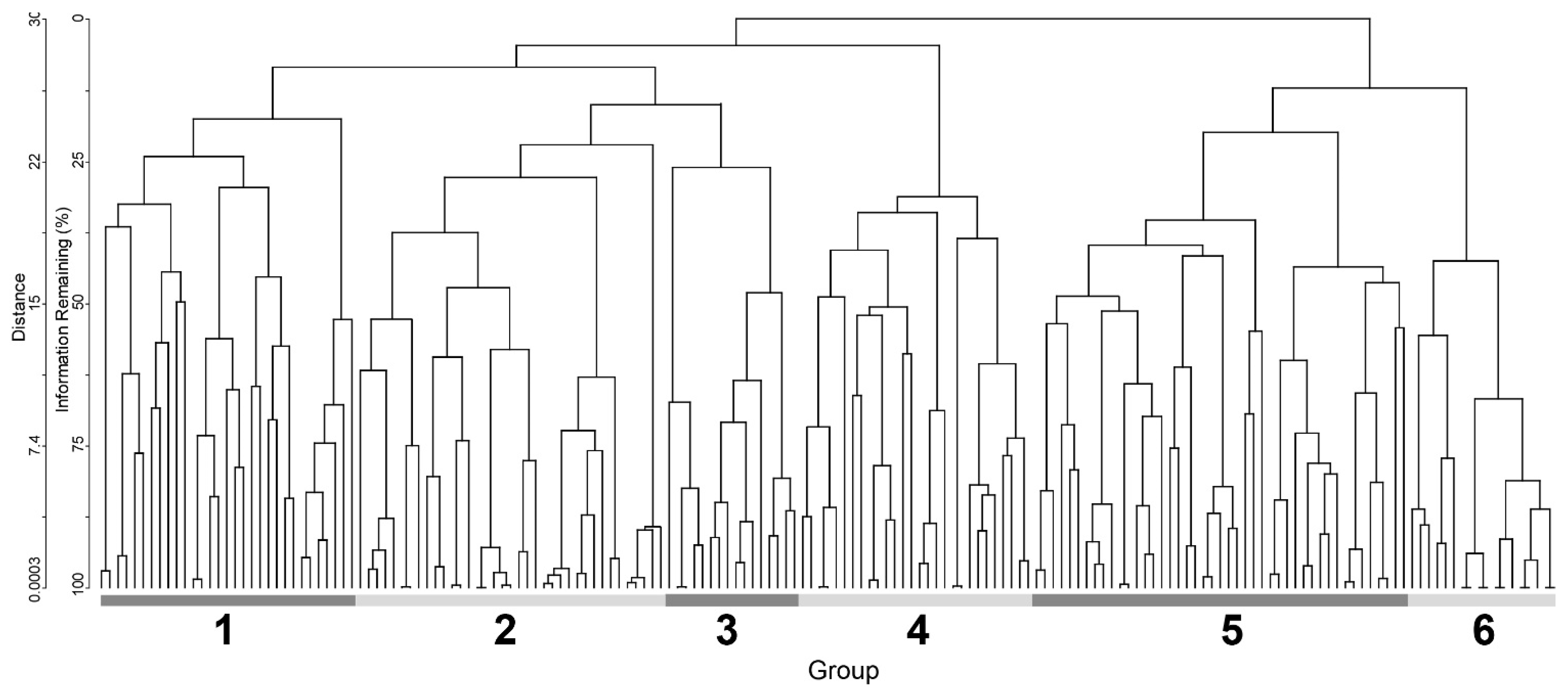
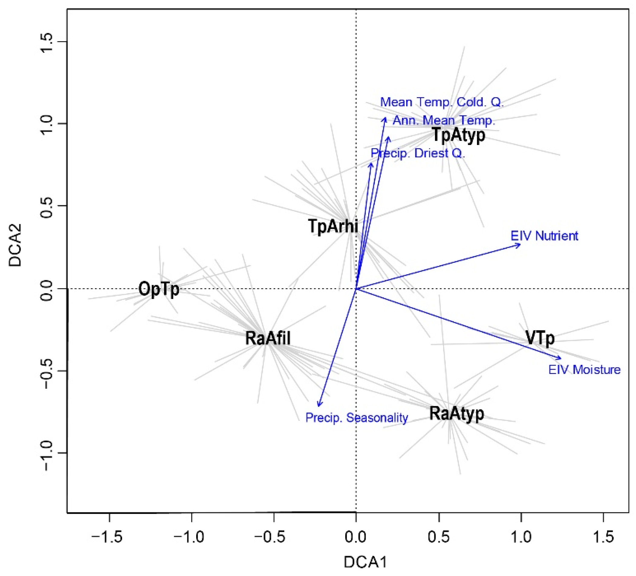
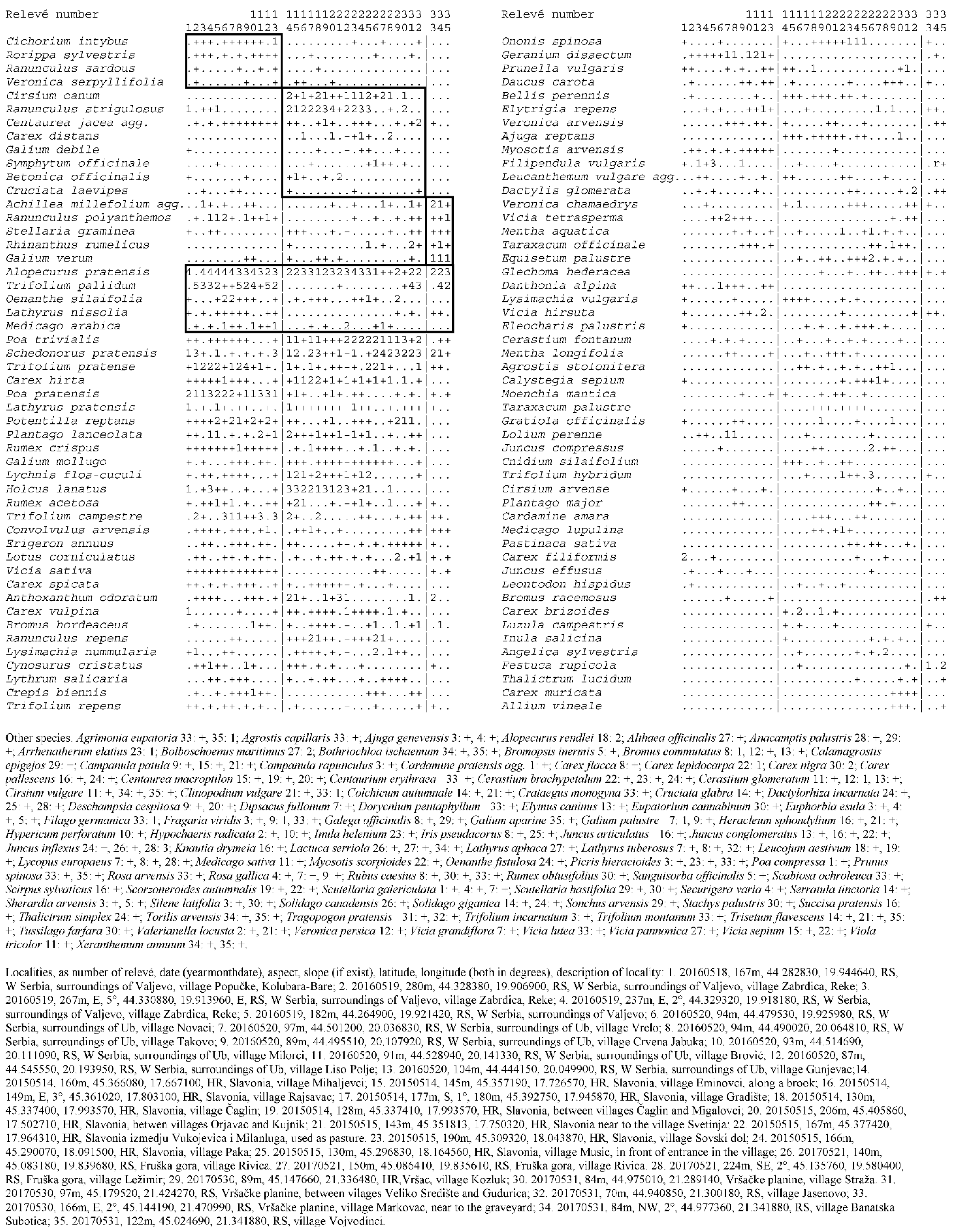
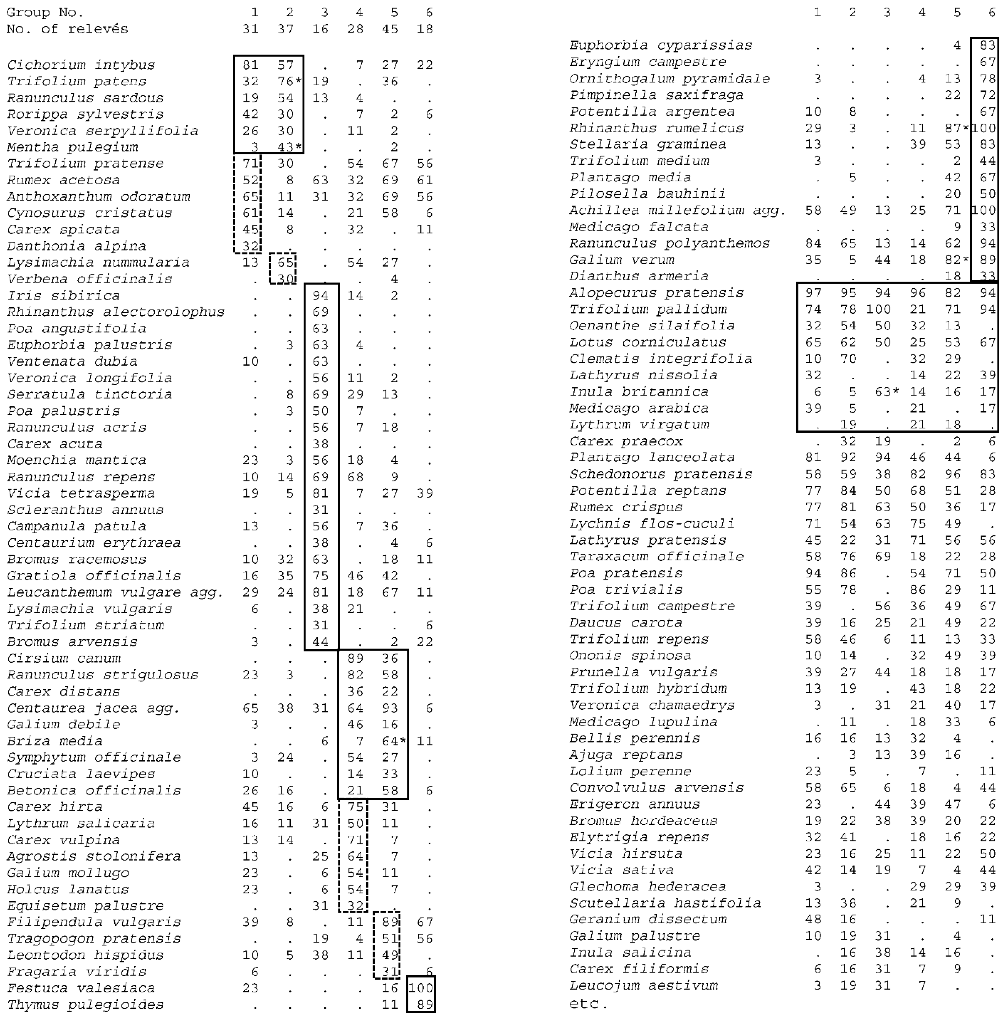
To reduce noise in the data, outlier analysis was conducted using PC-ORD 5.0 (MjM Software Design, Gleneden Beach, OR, USA), and four relevés whose species composition deviated more than ±2 SD from the mean calculated Euclidean distance of all plots were excluded. Finally, 175 relevés were included in the analysis, which contained a total of 321 taxa of vascular plants.
Classification of relevés was performed using cluster analysis in PC-ORD 5.0. The OptimClass method [52] for identifying the optimal partition suggested square root transformation of cover values of species, Beta flexible (β = −0.25) for group linkage with the relative Sørensen index as the distance measure.
Diagnostic species were determined by calculating fidelity using the phi (Φ) coefficient. Only species with Φ > 0.4 and a probability under the random expectation of the observed pattern of species occurrence lower than 0.001 (Fisher’s exact test) were considered diagnostic for associations and subassociations [53]. Diagnostic species of subassociations were calculated only within relevés classified to the relevant association. To calculate fidelity, the number of relevés for each (sub) association was virtually standardized to equal size [54].
Within this elaboration, we treated as diagnostic for the alliance Trifolion pallidi and order Trifolio–Hordeetalia all plant species that are considered diagnostic for these syntaxa in Horvatić [55], Ilijanić [13], Šilc et al. [56], and Škvorc et al. [23], as follows: Agrostis stolonifera subsp. maritima, Alopecurus pratensis, Alopecurus utriculatus, Anacamptis palustris subsp. palustris, Carex distans, Carex praecox, Centaurea angustifolia subsp. pannonica, Cirsium canum, Clematis integrifolia, Galium debile, Hordeum secalinum, Inula britanica, Lathyrus nissolia, Lotus tenuis, Lythrum virgatum, Medicago arabica, Oenanthe silaifolia, Poa pratensis, Poa trivialis (including subsp. sylvicola), Ranunculus polyanthemos, Ranunculus sardous, Ranunculus strigulous, Trifolium fragiferum, and Trifolium pallidum. We included some of them in the synthetic table (Figure A3) as diagnostic species of associations and excluded some widely distributed species, such as Poa pratensis and Poa trivialis (in which the subspecies sylvicola is often not distinguished).
Detrended correspondence analysis (DCA) was performed by the Vegan program [57] in the R program environment (https://cran.wu.ac.at/). The first two axes are presented on the diagram with passively projected climatic and ecological variables that show the highest correlation with the axes calculated by Spearman correlations. We prepared a synoptic table (Figure A3) and a table of new unpublished relevés used in the analysis (Figure A2); we also showed the distribution of individual syntaxa on the map and a map presenting literature and own field data (Figure A1).

3. Results

Classification analysis Figure 2 showed that relevés can be divided into six clusters (groups). They are consistent with the existing classification scheme, with the exception of Ventenato–Trifolietum, which has not appeared in previous analyses. The diagram shows four associations, two of which are subdivided into subassociations (Figure 2). These groups were the subject of further analysis.
EIV values for moisture Figure 3 show that the wettest sites are those of Ranunulo–Alopecuretum typicum, Ventenato–Trifolietum, and Trifolio–Alopecuretum typicum. At the same time, it was found that the nutrient status is highest within Ranunuculo–Alopecuretum typicum and Trifolio–Alopecuretum typicum, while there are fewer nutrients within Ventenato–Trifolietum. It must be taken into account that the moisture of sites is a result of inundations and higher groundwater table in combination with soil characteristics (clay). Inundations also bring nutrients to the sites, but this is not always the case with high groundwater, so the two properties are not necessarily parallel. It can be seen that Ornithogalo–Trifolietum appears on the driest and nutrient poorest stands, while the remaining groups, such as Ranunuculo–Alopecuretum filipenduletosum and Trifolio–Alopecuretum rhinanthetosum, possess an intermediate position in respect to these ecological factors. It can be seen that altitude has a very narrow range of 100 m and does not play an important role in the differentiation of groups. This division is also shown by the ecological division of groups reflected on the first axis of DCA analysis (Table 1 and Figure 4).
Climatic conditions reflect the geographic position of the studied plant communities (Figure 5 and Figure 6). There is more precipitation (mean annual, of the driest quarters) in Trifolio–Alopecuretum (both subassociations) appearing in the northern part of central Serbia. At the same time, the temperature regime is more propitious in this region (annual mean temperature, mean temperature of the coldest quarter). The climatic conditions become more severe (precipitation seasonality) in the regions toward the central Pannonian Plain, where Ranunuculo–Alopecuretum (both subassociations), Ornithogalo–Trifolietum, and Ventenato–Trifolietum can be found. Macroclimatic conditions correspond to the second DCA axis (Table 1 and Figure 4) and separate communities according to their geographical position (Figure 6). The number of plant species varies between the studied communities and reaches higher values in the subassociations (Figure 5), which occur on slightly drier sites than typical forms (Figure 3).
The DCA diagram shows the separation of groups along two gradients—axis 1 represents the ecological gradient, and axis 2 represents the macroclimatic (in our case also geographic) gradient (Figure 4 and Table 1).
Axis 1 shows the separation along EIV moisture and nutrient. Ventenato–Trifolietum, Trifolio–Alopecuretum typicum and Ranunculo–Alopecuretum typicum can be found in the wettest and most nutrient-rich sites; on drier and nutrient poorer sites, Trifolio–Alopecuretum rhinanthetosum, Ranunuculo–Alopecuretum filipenduletosum, and Ornithogalo–Trifolietum appear. Axis 2 shows the distinction between relevés appearing in the region under stronger influence of the Mediterranean climate in the northern part of central Serbia (Trifolio–Alopecuretum (both subassociations) and those from Vojvodina (northern Serbia) and eastern Croatia, where this influence diminishes (Ranunculo–Alopecuretum (both subassociations), Ornithogalo–Trifolietum, and Ventenato–Trifolietum).
Wet meadows of Trifolion pallidi appear along the southeastern margin of the Pannonian Plain because there is a certain influence of the Mediterranean climate from the south (e.g., along river Morava), which gradually diminishes toward the north (Table 1, Figure 6). Along this gradient, we can distinguish two associations of wet meadows that are widely distributed in the area, namely, Trifolio–Alopecuretum thriving in areas with a milder climate in the northern part of central Serbia and Ranunculo–Alopecuretum appearing northwards in the area in which the climate becomes harsher, i.e., in the area approximately till the line from Slavonsko Gorje over Fruška Gora to Vršačke Planine. Two associations have been described on small areas and represent local site conditions—Ventenato–Trifolietum in extremely wet conditions along the Danube and Drava River and Ornithogalo–Trifolietum in the driest conditions on Vršačke Planine. This distinction between the associations is predominately on a (macro)climatic scale.

4. Discussion

We confirmed the findings of Ilijanić [10,13], who reported that wet meadows of Trifolion pallidi appear in the eastern part of Croatia and northern Serbia. Ilijanić [13] also anticipated that such vegetation could also be found in southern Romania and northern Bulgaria, but it has not yet been reported from those regions [58,59]. However, some plant communities of a transitional character have been found there (e.g., [60]).
The present analysis is based on 20% of new field data. The new data did not produce their own clusters but were merged among existing syntaxa (Figure A1 and Figure A2). This indicates that no major change has appeared in species composition during different periods of sampling. It supports the estimation of [1], who found out that only a small percentage of the area of these communities is degraded (up to 20%), whereas the degree of degradation is slight (to moderate). We cannot judge about the extension of these communities from our data.
The Trifolion pallidi communities are distributed in the southeastern margin of the Pannonian Plain. The northern border coincides with the influence of the Mediterranean climate that comes from the south [32] and it extends from Slavonsko Gorje over Fruška Gora to Vršačke Planine. The transitional character of Ventenato–Trifolietum will be discussed below. The southern border coincides with the border of the Pannonian Plain [33].
Thermophilous deciduous oak forests of the alliances Quercion frainetto and Quercion pubescenti–petraeae and mesic oak-hornbeam forests of Erythronio–Carpinion appear in the area of distribution of Trifolion pallidi, but steppe woodlands of Aceri–Quercion, which appear on loess plateaus toward the north, cannot be found [30,61,62].
The hydrological gradient obtained on the base of EIV moisture values significantly correlated with axis 1 of DCA (Table 1), so we can confirm that the moisture gradient turned out as the most important factor in shaping the composition of the studied plant communities. Soil moisture and nutrient content have been shown to be the most important factors that determine the species composition of wet grasslands [63].
Any measures that would significantly change the extent or frequency of inundations of these sites or the level of groundwater would negatively influence the studied plant communities [64] and could eventually lead to changes of floristic composition and to substantial loss of regional biodiversity. The changes in hydrology would in the worst case cause the vanishing of this habitat type.
A distinction within associations on a local scale also exists, reflecting ecological site conditions. Two subassociations can be distinguished within each of the two broadly distributed associations; each reflects wetter and more nutrient-rich site conditions, on the one hand, and less wet and nutrient poorer conditions on the other. Ranunuculo–Alopecuretum typicum and Trifolio–Alopecuretum typicum can thus be found on wetter and more nutrient-rich sites and Ranunuculo–Alopecuretum filipenduletosum and Trifolio–Alopecuretum rhinanthetosum on less wet and nutrient poorer sites. The other two associations appear on a limited area and in fairly unique ecological site conditions, so they were not subdivided into subassociations. This distinction on a subassociation level is recognized on a local scale.

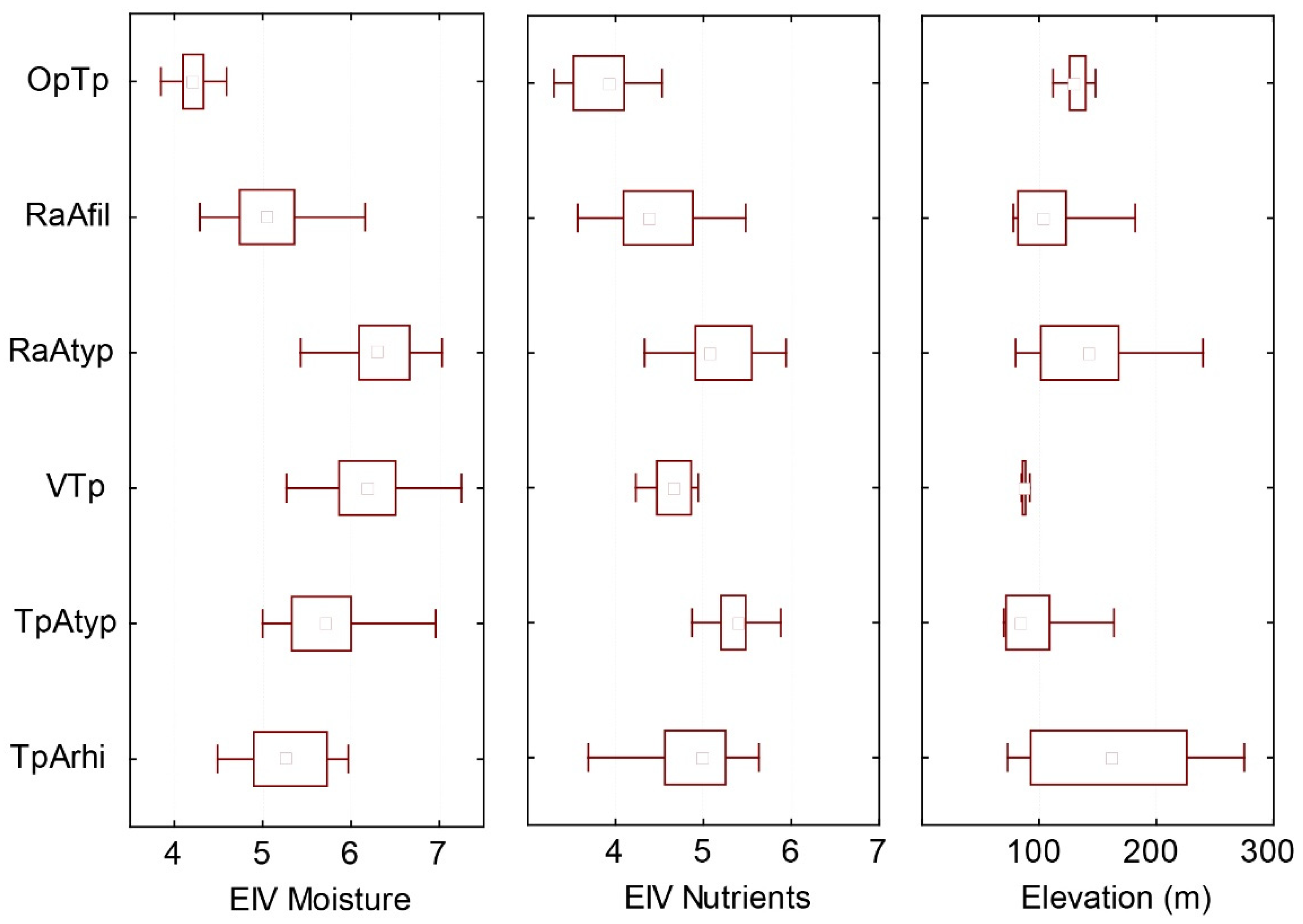
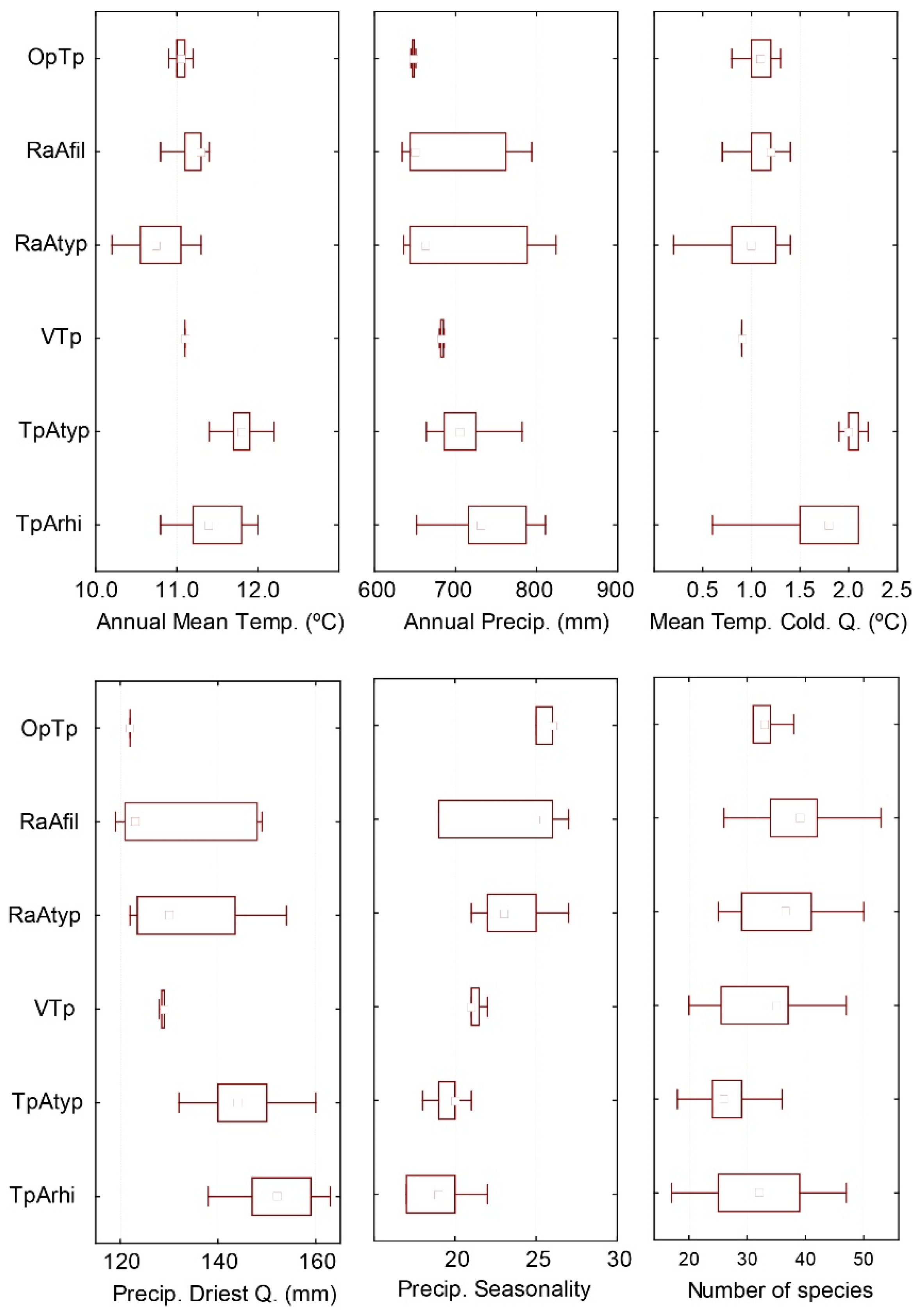
4.1. Description of Individual Plant Communities

4.1.1. Association Trifolio pallidi–Alopecuretum pratensis Cincović 1959

Diagnostic plant species: Cichorium intybus, Mentha pulegium, Ranunculus sardous, Rorippa sylvestris, Trifolium patens, Veronica serpyllifolia.
Nomenclatural remark. The association was lectotypified in Aćić et al. [65] (p. 46). As lectotype, they selected Cincović 1959 [12]: (Table 3, rel. 22). According to Cincović [12], this relevé belongs to the subassociation rhinanthetosum rumelici. Article 19a [51] stated that a lectotype must be chosen from relevés assigned to the subassociation typicum, if such a subassociation exists. In Cincović [12], such a subassociation does exist and this makes the lectotypification invalid. We select here as lectotype of the association Trifolio pallidi–Alopecuretum pratensis: Cincović 1959 [12]: Table 3, relevé 14, lectotypus hoc loco. This relevé is also the autonym of the subassociation typicum (Art. 13b). At the same time, we typify the subassociation Trifolio pallidi–Alopecuretum pratensis rhinanthetosum rumelici Cincović 1959, as lectotype: Cincović 1959 [12]: Table 3, rel. 23, lectotypus hoc loco.
This association appears in the northern part of central Serbia. It covers about half of the grassland area in the region and forms a large part of wet meadows along rivers in northwestern Serbia. These plant communities appear over fairly broad ecological conditions, from regularly inundated riverbanks to extreme sites that are barely reached by inundation water. The level of groundwater also varies significantly in these sites [12].
These meadows can easily be recognized in the landscape at the end of spring by the grey-green color of flowering Alopecurus pratensis. Communities are two-layered. The upper layer is formed by Alopecurus pratensis, Festuca pratensis, Rumex crispus, Cichorium intybus, and Thalictrum flavum, while in the lower layer, Trifolium pallidum, Trifolium patens, and Poa pratensis appear. The lower layer is denser than the upper one and forms a close canopy, so other plant species have difficulty appearing there [11].
The association has been divided into several subassociations (caricetosum, rhinanthetosum rumelici, trifolietum hybridi, and typicum) by Cincović [11,12], but analysis shows that only two subtypes can be distinguished at the level of subassociation—typicum and rhinanthetosum rumelici.
The subassociation rhinanthetosum rumelici is differentiated by Anthoxanthum odoratum, Carex spicata, Cynosurus cristatus, Danthonia alpina, Rumex acetosa, and Trifolium pratense. It appears at the limit of the inundation area on alluvial terraces and is rarely inundated. In addition, the level of groundwater is deep, between 3 m and 5 m below the surface during the vegetation season. This subassociation encompasses drier forms of communities [12].
The subassociation typicum is differentiated by Lysimachia nummularia, Mentha pulegium, Trifolium patens, and Verbena officinalis. It includes the majority of the other three subassociations described by Cincović [11,12] and Škvorc et al. [23], as caricetosum Cincović 1956 nom. inval. (Art. 4), trifolietosum hybridi Cincović 1959 and lysimachietosum nummulariae Ćuk in Škvorc et al. 2020. It appears in the inundation area along rivers and is periodically under water every year at the end of spring and beginning of summer although the duration depends on the amount of water in the particular year. The groundwater table is high—from only 10 cm to 180 cm below the surface [12].

4.1.2. Association Ventenato dubii–Trifolietum pallidi Ilijanić 1968

Diagnostic plant species: Bromus arvensis, Bromus racemosus, Campanula patula, Carex acuta, Centaurium erythraea, Euphorbia palustris, Gratiola officinalis, Inula britannica, Iris sibirica, Leucanthemum vulgare agg., Lysimachia vulgaris, Moenchia mantica, Poa angustifolia, Poa palustris, Ranunculus acris, Ranunculus repens, Rhinanthus alectorolophus, Scleranthus annuus, Serratula tinctoria, Trifolium striatum, Ventenata dubia, Veronica longifolia, Vicia tetrasperma.
Nomenclatural remark. We selected the lectotype of the association Ventenato dubii–Trifolietum pallidi as Ilijanić 1968 [38]: Table 3, rel. 15, lectotypus hoc loco.
The association has been described from the area along the Drava River north of Osijek. These plant communities appear on the riverbanks of the small Krašica River, on the boundary of the inundation area, but the soil is heavy and clayey and well maintains humidity. It mediates among Molinion, Deschampsion (syn. Cnidion), and Trifolion pallidi [23,38,40]. The floristic composition is a mixture of the diagnostic species of all three alliances: Molinion (Iris sibirica, Gentiana pneumonanthe), Deschampsion (Serratula tinctoria, Gratiola officinalis), and Trifolion pallidi (Trifolium pallidum, Oenanthe silaifolia). Three therophytic species (Trifolium pallidum, Ventenata dubia, and Trifolium striatum) can be observed, which were considered to be characteristic species of this association [38]. Communities are (co)dominated by Alopecurus pratensis. This association has been divided into two subassociations—poetosum palustris and lotetosum corniculati Ilijanić [38].
In a broader analysis [23], the relevés of this association were partly classified among outliers and partly classified within Trifolio–Alopecuretum. The results of this large-scale analysis and the appearance of many Trifolion pallidi species persuaded us to include these transitional relevés in the analysis, where this association occurred. Additional analysis should be done in the future to clarify its synsystematic position. The present analysis does not support its further division into subassociations.

4.1.3. Association Ranunuculo strigulosi–Alopecuretum pratensis Vučković ex Aćić et al. 2013 mut. Ćuk in Čarni et al. 2021

Diagnostic plant species: Betonica officinalis, Briza media, Carex distans, Centaurea jacea agg., Cirsium canum, Cruciata laevipes, Galium debile, Ranunculus strigulosus, Symphytum officinale.
Nomenclatural remark. This association was invalidly described by Vučković [43] as Ranunculus stevenii–Alopecuretum but was later validated by Aćić et al. [65] as Ranunculo acris–Alopecuretum pratensis with Ranunculus acris L. 1753 as the name-giving taxon. We think that the species Ranunculus strigulosus (formerly misinterpreted as Ranunculus steveni Andrz. 1814) from the Ranunculus acris complex better describes the association because Ranunculus strigulosus Schur 1866 is a typical species of wet meadows in southeastern Europe. This concept is accepted in various regional floras [66] (p. 142) [67] (p. 552). We therefore propose mutation of the association name Ranunculo acris–Alopecuretum pratensis Vučković ex Aćić et al. 2013 [65] (p. 46) to Ranunculo strigulosi–Alopecuretum pratensis Vučković ex Aćić et al. 2013 mut. Ćuk in Čarni et al. nomen mutatum novum according to Art. 45 [51].
The species Ranunculus strigulosus has been misinterpreted in several regional floras as Ranunculus steveni or R. stevenii (e.g., [68,69]) [70]. The species in these communities (also in the table published by Vučković [43]) is thus Ranunculus strigulosus.
The association appears over a large area between Slavonsko Gorje and Vršačke Planine. It appears on deep soils that are wet, fertilized, and periodically inundated. According to an analysis made by Vučković [43], a comparison of this association with the Trifolio–Alopecuretum, thriving in the northern part of central Serbia, shows more hemicryptophyes and fewer therophytes, as well as more Eurasian and fewer sub-Mediterranean species; the differences are still more pronounced in comparison with associations appearing further toward the south (classified within Trifolion resupinati).
We have also integrated Oenanthno banaticae–Alopecuretum pratensis Parabućski et Stojanović ex Aćić at al. 2013, Ononido spinosifolii–Alopecuretum pratensis Butorac ex Aćić et al. 2013 and Rhinantho rumelici–Filipenduletum vulgaris Ilijanić 1969 (phantom name in Rauš et al. [40] (p. 321)) within this association.
Two subassociations, typicum and filipenduletosum Škvorc et al. 2020, can be distinguished, based on humidity and nutrient availability. The results of the analysis are not in accordance with [23], who integrated the whole association Oenantho banaticaeAlopecuretum pratensis within RanunculoAlopecuretum pratensis, as a drier subassociation filipenduletosum. The present analysis shows that only the drier subassociation (Oenanthno–Alopecuretum filipenduletosum Parabućski et Stojanović 1988 nom. inval. (Art. 5)) can be classified within the drier subassociation Ranunculo–Trifolietum filipenduletosum, whereas the subassociation from more humid sites (Oenantho–Alopecuretum bolboschenetosum Parabućski et Stojanović 1988 nom. inval. (Art. 5)) is classified within the typical subassociation due to the presence of many hygrophilous species, such as Gratiola officinalis, Bolboschoenus maritimus, and Trifolium hybridum, and the lack of thermophilous species, such as Filipendula vulgaris, Leucanthemum vulgare, Rhinanthus rumelicus, Festuca valesiaca, etc. appearing in the drier subassociation [42].
The subassociation typicum is differentiated by Agrostis stolonifera, Carex hirta, Carex vulpina, Equisetum palustre, Galium mollugo, Holcus lanatus, and Lythrum salicaria. It appears on wetter and more nutrient-rich sites. We classified Ranunculo–Alopecuretum oenanthetosum banaticae Vučković 1991 nom. inval. (Art. 5, Art. 13 b) (the nomenclatural type of the association is within this subassociation), Oenathae–Alopecuretum bolboschenetosum and Ononido–Alopecuretum within this subassociation.
The subassociation filipenduletosum vulgaris is differentiated by Briza media, Filipendula vulgaris, Fragaria viridis, Galium verum, Leontodon hispidus, Rhinanthus rumelicus, and Tragopogon pratensis. It appears on drier sites that are nutrient poorer. Within this subassociation are also classified Ranunculo–Alopecuretum rumicetosum acetosae Vučković 1991 nom. inval. (Art. 5), Ranunulo–Alopecuretum stahyetosum officinalis Vučković 1991 nom. inval. (Art. 5), Oenantho–Alopecuretum filipenduletosum, and Rhinantho rumelici–Filipenduletum.

4.1.4. Association Ornithogalo pyramidale–Trifolietum pallidi Vučković ex Aćić et al. 2013

Diagnostic plant species: Achillea millefolium agg., Dianthus armeria, Eryngium campestre, Euphorbia cyparissias, Festuca valesiaca, Galium verum, Medicago falcata, Ornithogalum pyramidale, Pilosella bauhinii, Pimpinella saxifraga, Plantago media, Potentilla argentea, Ranunculus polyanthemos, Rhinanthus rumelicus, Stellaria graminea, Thymus pulegioides, Trifolium medium.
The association possesses a very limited distribution area, being found only on the southern slopes of Vršačke Planine. It is named after two sub-Mediterranean plant species, Trifolium pallidum and Ornithogalum pyramidale. The sites are drier and nutrient poorer than those of the previous associations and it is transitional to dry grasslands of Festuco–Brometea [43]. Two subassociations have been described within this association—Ornithogalo–Trifolietum trifolietosum pallidi Vučković 1991 nom. inval. (Art. 5) and Ornithogalo–Trifolietum rhinanthetosum rumelici Vučković 1991 nom. inval. (Art. 5), but our analysis did not confirm the division into lower syntaxa.

4.2. Syntaxomomic Scheme of the Studied Plant Communities

  • Molinio–Arrhenatheretea Tx. 1937
  • Trifolio–Hordeetalia Horvatić 1963
  • Trifolion pallidi Ilijanić 1969
  • Trifolio pallidi–Alopecuretum pratensis Cincović 1959
    • typicum
    • rhinathetosum rumelici Cincović 1959
  • Ventenato–Trifolietum pallidi Ilijanić 1968
  • Ranunculo strigulosi–Alopecuretum pratensis M. Vučković ex Aćić et al. 2013 mut. Ćuk in Čarni et al. 2021
    • typicum
    • filipenduletosum Škvorc et al. 2020
  • Ornithogalo pyramidale–Trifolietum pallidi M. Vučković ex Aćić et al. 2013

5. Conclusions

The article presents species-rich plant communities of the wet meadows that harbor a major part of regional biodiversity. The continuation of mowing and safeguarding against inappropriate hydrological interventions are key factors for maintaining these communities [71,72]. The main threats to these habitats are changes of traditional management practice, which could be abandonment leading to reforestation, or intensification of agriculture through fertilization and drainage [1]. Changes in hydrological conditions such as changes in the extent or frequency of inundations or changes in the level of groundwater on these sites would negatively influence these plant communities. The changes in hydrology would in the worst-case cause the vanishing of this habitat type [64].
We have provided new field data about this habitat type that has not been sampled for decades. They prove that it is still of good quality, worth protecting, and it deserves integration in the Habitat Directive.

Author Contributions

Conceptualization, A.Č., M.Ć., and Ž.Š.; Data curation, Ž.Š.; Formal analysis, J.F., D.K., and Ž.Š.; Funding acquisition, A.Č., I.Z., J.F., R.I., D.V., and Ž.Š.; Investigation, A.Č., M.Ć., J.F., D.K., and Ž.Š.; Methodology, A.Č.; Project administration, Ž.Š.; Resources, A.Č., M.Ć., and Ž.Š.; Software, Ž.Š.; Supervision, A.Č.; Validation, A.Č., I.Z., R.I., M.I., and Ž.Š.; Visualization, D.K. and Ž.Š.; Writing—original draft preparation, A.Č., M.I., and D.V.; Writing—review and editing, A.Č., I.Z., R.I., M.I., D.V., and Ž.Š. All authors have read and agreed to the published version of the manuscript.

Funding

This paper resulted from bilateral projects between Serbia and Croatia “Diversity of Vegetation of Wet Meadows in a Climatic Gradient along the Southern Edge of the Pannonian Plain” financed by the Ministry of Education, Science, and Technological Development of the Republic of Serbia and the Ministry of Science and Education of the Republic of Croatia. A. Čarni and I. Zelnik were supported by projects of the Slovenian Research Agency (ARRS, P1-0236 and ARRS, P1-0212). M. Ćuk, R. Igić, M. Ilić, and D. Vukov were supported by the Ministry of Education, Science, and Technological Development of the Republic of Serbia (grant no. III 43002).

Institutional Review Board Statement

Not applicable.

Informed Consent Statement

Not applicable.

Data Availability Statement

Study is based on published material [11,12,38,39,40,41,42,43,44] and new field data Figure A2.

Conflicts of Interest

The authors declare no conflict of interest. The funders had no role in the design of the study; in the collection, analyses, or interpretation of data, in the writing of the manuscript, or in the decision to publish the results.

Appendix A

Figure A1. The geographical position of original relevés from fieldwork sampling and relevés collected from the literature.
Water 13 00381 g0a1
Figure A2. Analytic table of the new field data used in the analysis. The relevés are classified in accordance with Figure A3, diagnostic species of the associations are framed. The following associations were sampled: 1–13 Trifolio pallidi–Alopecuretum pratensis, 14–32 Ranunculo strigulosi–Alopecuretum pratensis, and 33–35 Ornithogalo pyramidale–Trifolietum pallidi.
Water 13 00381 g0a2
Figure A3. Percentage synoptic table of the Trifolion pallidi meadows. Diagnostic species of syntaxa are framed or indicated by asterisk. Diagnostic species of the Trifolion pallidi and Trifolio–Hordeetalia are from literature. Legend to columns: 1—Trifolio pallidiAlopecuretum rhinanthetosum rumelici, 2—Trifolio pallidiAlopecuretum typicum, 3—Ventenato–Trifolietum pallidi, 4—Ranunculo acris–Alopecuretum typicum, 5—Ranunculo acris–Alopecuretum filipenduletosum, 6—Ornithogalo pyramidaleTrifolietum pallidi.
Water 13 00381 g0a3

References

  1. Janssen, J.A.M.; Rodwell, J.S.; García Criado, M.; Gubbay, S.; Haynes, T.; Nieto, A.; Sanders, N.; Landucci, F.; Loidi, J.; Symank, A.; et al. European Red List of Habitats. Part 2. Terrestrial and Freshwater Habitats; European Union: Luxembourg, 2016; p. 44. [Google Scholar] [CrossRef]
  2. Dwire, K.A.; Kauffman, J.B.; Brookshire, E.N.J.; Baham, J.E. Plant biomass and species composition along an environmental gradient in montane riparian meadows. Oecologia 2004, 139, 309–317. [Google Scholar] [CrossRef] [PubMed]
  3. Luo, W.B.; Song, F.B.; Xie, Y.H. Trade-off between tolerance to drought and tolerance to flooding in three wetland plants. Wetlands 2008, 28, 866–873. [Google Scholar] [CrossRef]
  4. Chen, X.; Li, X.; Xie, Y.; Li, F.; Hou, Z.; Zeng, J. Combined influence of hydrological gradient and edaphic factors on the distribution of macrophyte communities in Dongting Lake wetlands (China). Wetl. Ecol. Manag. 2015, 23, 481–490. [Google Scholar] [CrossRef]
  5. Gaberščik, A.; Krek, J.L.; Zelnik, I. Habitat diversity along a hydrological gradient in a complex wetland results in high plant species diversity. Ecol. Eng. 2018, 118, 84–92. [Google Scholar] [CrossRef]
  6. Moran, J.; Skeffington, M.S.; Gormally, M. The influence of hydrological regime and grazing management on the plant communities of a karst wetland (Skealoghan turlough) in Ireland. Appl. Veg. Sci. 2008, 11, 13–24. [Google Scholar] [CrossRef]
  7. Dolinar, N.; Rudolf, M.; Šraj, N.; Gaberščik, A. Environmental changes affect ecosystem services of the intermittent Lake Cerknica. Ecol. Complex. 2010, 7, 403–409. [Google Scholar] [CrossRef]
  8. Grime, J.P. Competitive exclusion in herbaceous vegetation. Nature 1973, 242, 344–347. [Google Scholar] [CrossRef]
  9. Grime, J.P. Plant Strategies Vegetation Processes and Ecosystem Properties, 2nd ed.; Wiley: Chichester, UK, 2001; p. 417. [Google Scholar]
  10. Ilijanić, L. Typologisch-geographische Gliederung der Niederungswiesen Nordkroatiens im klimatischen Zusammenhang. Acta Bot. Croat. 1963, 22, 119–132. [Google Scholar]
  11. Cincović, T. Tipovi livada u Posavini. Zb. Rad. Poljopr. Fak. Beograd. 1956, 4, 31–56. [Google Scholar]
  12. Cincović, T. Livadska vegetacija u rečnim dolinama zapadne Srbije. Zb. Rad. Poljopr. Fak. Beograd. 1959, 7, 1–62. [Google Scholar]
  13. Ilijanić, L. Das Trifolion pallidi, ein neuer Verband der Ordnung Trifolio-Hordeetalia H-ić. Acta Bot. Croat. 1969, 28, 151–160. [Google Scholar]
  14. Mucina, L.; Bültmann, H.; Dierßen, K.; Theurillat, J.P.; Raus, T.; Čarni, A.; Šumberová, K.; Willner, W.; Dengler, J.; Gavilán, R.G.; et al. Vegetation of Europe: Hierarchical floristic classification system of vascular plant, bryophyte, lichen, and algal communities. Appl. Veg. Sci. 2016, 19 (Suppl. 1), 3–264. [Google Scholar] [CrossRef]
  15. Purger, D. Subterranean clover (Trifolium subterraneum L.) in communties in the Great Hungraian Plain: Questions of coenology, nomenclature and syntaxonomy. Acta Bot. Hung. 2006, 46, 399–413. [Google Scholar] [CrossRef]
  16. Zeidler, H. Das Alopecurion utriculati, ein neuer Verband Balkanischer Wiesengesellschaften. Vegetatio 1954, 5–6, 292–301. [Google Scholar] [CrossRef]
  17. Jovanović, R. Tipovi dolinskih livada Jasenice. Arch. Biol. Sci. 1957, 9, 1–14. [Google Scholar]
  18. Rodríguez-Rojo, M.P.; Jiménez-Alfaro, B.; Jandt, U.; Bruelheide, H.; Rodwell, J.S.; Schaminée, J.H.J.; Perrin, P.M.; Kącki, Z.; Willner, W.; Fernández-González, F.; et al. Diversity of lowland hay meadows and pastures in Western and Central Europe. Appl. Veg. Sci. 2017, 20, 702–719. [Google Scholar] [CrossRef]
  19. Goncharenko, I.; Kozyr, M.; Senchylo, O. Classification of the floodplain meadows of the Seym and the Dnieper river valleys in the north-eastern part of Ukraine. Biologia 2020, 75, 53–70. [Google Scholar] [CrossRef]
  20. Deák, B.; Valkó, O.; Török, P.; Tóthmérész, B. Solonetz meadow vegetation (Beckmannion eruciformis) in East-Hungary—An alliance driven by moisture and salinity. Tuexenia 2014, 34, 187–203. [Google Scholar] [CrossRef]
  21. Zaliberová, M.; Škodová, I. Potentillion anserinae. In Rastlinné Spoločenstvá Slovenska. 5. Travinno-Bylinná Vegetácia; Hegedüšová Vantarová, K., Škodová, I., Eds.; Veda: Bratislava, Slovakia, 2014; pp. 331–350. [Google Scholar]
  22. Botta-Dukát, Z.; Chytrý, M.; Hájková, P.; Havlová, M. Vegetation of lowland wet meadows along a climatic continentality gradient in Central Europe. Preslia 2005, 77, 89–111. [Google Scholar]
  23. Škvorc, Ž.; Ćuk, M.; Zelnik, I.; Franjić, J.; Igić, R.; Ilić, M.; Krstonošić, D.; Vukov, D.; Čarni, A. Diversity of wet and mesic grasslands along a climatic gradient on the southern margin of the Pannonian Basin. Appl. Veg. Sci. 2020, 23, 676–697. [Google Scholar] [CrossRef]
  24. Borhidi, A.; Kevey, B.; Lendvai, G. Plant Communities of Hungary; Akadémiai Kiadó: Budapest, Hungary, 2012; p. 544. [Google Scholar]
  25. Chytrý, M.; Tichý, L.; Hennekens, S.M.; Knollová, I.; Janssen, J.A.; Rodwell, J.S.; Peterka, T.; Marcenò, C.; Landucci, F.; Danielka, J.; et al. EUNIS Habitat Classification: Expert system, characteristic species combinations and distribution maps of European habitats. Appl. Veg. Sci. 2020, 23, 648–675. [Google Scholar] [CrossRef]
  26. European Council. Council Directive 92/43/EEC of 21 May 1992 on the Conservation of natural habitats and of wild fauna and flora. Off. J. Eur. Union 1992, 206, 7–50. [Google Scholar]
  27. European Commission. Interpretation Manual of European Union Habitats; European Commission, DG Environment: Brussels, Belgium, 2013; p. 144. [Google Scholar]
  28. Zaninović, K.; Gajić-Čapka, M.; Perčec Tadić, M.; Vučetić, N.; Milković, J.; Bajić, A.; Cindrić, L.; Cvitan, L.; Katušin, Z.; Kaučić, D.; et al. Climate Atlas of Croatia 1961–1990, 1971–2000; Državni Hidrometeorološki Zavod: Zagreb, Croatia, 2008; p. 200. [Google Scholar]
  29. Milovanović, B. Climate regionalization of Serbia according to Köppen climate classification. J. Geogr. Inst. Jovan Cvijic SASA 2017, 67, 103–114. [Google Scholar] [CrossRef] [Green Version]
  30. Stupar, V. Mesophilous Quercus frainetto dominated forests from Western Balkans. South-East Eur. For. 2020, 11, 97–110. [Google Scholar] [CrossRef]
  31. Vukelić, J. Šumska Vegetacija Hrvatske; Sveučilište u Zagrebu: Zagreb, Croatia, 2012; p. 403. [Google Scholar]
  32. Pantović, J.; Grdović, S.; Veljić, M.; Sabovljević, M.S. Biogeographic traits of the bryophyte flora of Serbia. Bot. Serbica 2019, 43, 143–150. [Google Scholar] [CrossRef] [Green Version]
  33. Ćalić, J.; Gaudenyi, T.; Milošević, M.V.; Štrbac, D.; Milivojević, M. Geomorphometrical method for delineation of plains-case study of the south-eastern (Serbian) segment of the Pannonian Plain. Carpathian J. Earth Environ. Sci. 2012, 7, 239–248. [Google Scholar]
  34. Adamović, L. Die Vegetationsverhältnisse der Balkanländer (Mösische Länder): Umfassend Serbien, Altserbien, Bulgarien, Ostrumelien, Nordthrakien und Nordmazedonien; Vegetation der Erde 11; W. Engelmann: Leipzig, Germany, 1909; p. 567. [Google Scholar]
  35. Oberdorfer, E. Gliederung und Umgrenzung der Mittelmeervegetation auf der Balkanhalbinsel. Ber. Geobot. Forsch. Rübel 1948, 1974, 84–111. [Google Scholar]
  36. Braun-Blanquet, J. Pflanzensoziologie, Grundzüge der Vegetationskunde, 3rd ed.; Springer Verlag: Wien, Austria, 1964; p. 631. [Google Scholar]
  37. Westhoff, V.; van der Maarel, E. The Braun-Blanquet approach. In Handbook of Vegetation Science 5, Classification and Ordination of Communities; Whittaker, R.H., Ed.; Dr. W. Junk: The Hague, The Netherlands, 1973; pp. 287–399. [Google Scholar]
  38. Ilijanić, L. Die Ordnung Molinetalia in der Vegetation Nordostkroatiens. Acta Bot. Croat. 1968, 26–27, 161–179. [Google Scholar]
  39. Cindrić, M. Biljni Pokrov Podnožja Dilj-Gore Sjeveroistočno od Slavonskog Broda. Master’s Thesis, University of Zagreb, Zagreb, Croatia, 1974. [Google Scholar]
  40. Rauš, Đ.; Šegulja, N.; Topić, J. Vegetacija sjeveroistočne Hrvatske. Glas. šumske pokuse 1985, 23, 223–355. [Google Scholar]
  41. Šegulja, N.; Topić, J. Prilog poznavanju pašnjaka istočne Slavonije. Poljopr. Znan. Smotra. 1978, 46, 91–94. [Google Scholar]
  42. Parabućski, S.; Stojanović, S. Oenanthe (banatica)-Alopecuretum pratensis ass. nova. Zb. Matice Srp. Prir. Nauke. 1988, 74, 71–78. [Google Scholar]
  43. Vučković, M. Livadska i Livadsko-Stepska Vegetacija Vršačkih Planina; Matica Srpska, Odeljenje za Prirodne Nauke: Novi Sad, Serbia, 1991; p. 95. [Google Scholar]
  44. Butorac, B. Vegetacija Fruškogorskog Lesnog Platoa, Monografija Fruške Gore; Matica Srpska, Odeljenje za Prirodne Nauke: Novi Sad, Serbia, 1992; p. 163. [Google Scholar]
  45. Hennekens, S.M.; Schaminée, J.H.J. TURBOVEG, a comprehensive data base management system for vegetation data. J. Veg. Sci. 2001, 12, 589–591. [Google Scholar] [CrossRef]
  46. Tichý, L. JUICE, software for vegetation classification. J. Veg. Sci. 2002, 13, 451–453. [Google Scholar] [CrossRef]
  47. Trinajstić, I. Biljne Zajednice Republike Hrvatske; Akademija Šumarskih Znanosti: Zagreb, Croatia, 2008; p. 179. [Google Scholar]
  48. Ellenberg, H.; Weber, H.E.; Düll, R.; Wirth, V.; Werner, W.; Paulißen, D. Zeigerwerte von Pflanzen in Mitteleuropa; Erich Goltze: Göttingen, Germany, 1992; p. 248. [Google Scholar]
  49. Fick, S.E.; Hijmans, R.J. Worldclim 2: New 1-km spatial resolution climate surfaces for global land areas. Int. J. Climatol. 2017, 37, 4302–4315. [Google Scholar] [CrossRef]
  50. Euro + Med Plantbase. Available online: https://www.emplantbase.org (accessed on 20 November 2020).
  51. Theurillat, J.P.; Willner, W.; Fernández-González, F.; Bültmann, H.; Čarni, A.; Gigante, D.; Mucina, L.; Weber, H.E. International Code of Phytosociological Nomenclature, 4th edition. Appl. Veg. Sci. 2020, 24. [Google Scholar] [CrossRef] [Green Version]
  52. Tichý, L.; Chytrý, M.; Hájek, M.; Talbot, S.S.; Botta-Dukát, Z. OptimClass: Using species-to-cluster fidelity to determine the optimal partition in classification of ecological communities. J. Veg. Sci. 2010, 21, 287–299. [Google Scholar] [CrossRef]
  53. Chytrý, M.; Tichý, L.; Holt, J.; Botta-Dukát, Z. Determination of diagnostic species with statistical fidelity measures. J. Veg. Sci. 2002, 13, 79–90. [Google Scholar] [CrossRef]
  54. Tichý, L.; Chytrý, M. Statistical determination of diagnostic species for site groups of unequal size. J. Veg. Sci. 2006, 17, 809–818. [Google Scholar] [CrossRef]
  55. Horvatić, S. Vegetacijska karta otoka Paga s općim pregledom vegetacijskih jedinica Hrvatskog primorja. Prir. Istraž. Jugosl. Akad. 1963, 33, 1–187. [Google Scholar]
  56. Šilc, U.; Aćić, S.; Škvorc, Ž.; Krstonošić, D.; Franjić, J.; Dajić Stevanović, Z. Grassland vegetation of the Molinio-Arrhenatheretea class in the NW Balkan Peninsula. Appl. Veg. Sci. 2014, 17, 591–603. [Google Scholar] [CrossRef]
  57. Oksanen, J.; Blanchet, F.G.; Friendly, M.; Kindt, R.; Legendre, P.; McGlinn, D.; Minchin, P.R.; O’Hara, R.B.; Simpson, G.L.; Solymos, P.; et al. Package “vegan”. Community Ecology Package. Available online: https://cran.rproject.org/web/packages/vegan (accessed on 20 January 2020).
  58. Sanda, V.; Öllerer, K.; Burescu, P. Fitocenozele din Romania-Sintaxonomie, Structura, Dinamica si Evolutie; Ars Docendi: Bucureşti, Romania, 2008; p. 570. [Google Scholar]
  59. Tzonev, R.T.; Dimitrov, M.A.; Roussakova, V.H. Syntaxa according to the Braun-Blanquet approach in Bulgaria. Phytol. Balc. 2009, 15, 209–233. [Google Scholar]
  60. Karácsonyi, C. Two new meso-hygrophytic plant communities in the northern part of Dealurile de Vest (Western Hills) area (Romania). Contrib. Bot. 2011, 46, 7–15. [Google Scholar]
  61. Čarni, A.; Košir, P.; Karadžić, B.; Matevski, V.; Redžić, S.; Škvorc, Ž. Thermophilous deciduous forests in Southeastern Europe. Plant Biosyst. 2009, 143, 1–13. [Google Scholar] [CrossRef]
  62. Purger, D.; Lengyel, A.; Kevey, B.; Lendvai, G.; Horváth, A.; Tomić, Z.; Csiky, J. Numerical classification of oak forests on loess in Hungary, Croatia and Serbia. Preslia 2014, 87, 47–66. [Google Scholar]
  63. Zelnik, I.; Čarni, A. Plant species diversity and composition of wet grasslands in relation to environmental factors. Biodivers. Conserv. 2013, 22, 2179–2192. [Google Scholar] [CrossRef]
  64. Stromberg, J.C. Restoration of riparian vegetation in the south-western United States: Importance of flow regimes and fluvial dynamism. J. Arid. Environ. 2002, 49, 17–34. [Google Scholar] [CrossRef] [Green Version]
  65. Aćić, S.; Šilc, U.; Lakušić, D.; Vukojičić, S.; Dajić Stevanović, Z. Typification and correction of syntaxa from the class Molinio-Arrhenatheretea Tx. 1937 in Serbia. Hacquetia 2013, 12, 39–54. [Google Scholar] [CrossRef]
  66. Martinčič, A. Mala Flora Slovenije. Ključ za Določanje Praprotnic in Semenk, 4th ed.; Tehniška Založba Slovenije: Ljubljana, Slovenia, 2007; p. 967. [Google Scholar]
  67. Nikolić, T. Flora Croatica–Vaskularna flora Republike Hrvatske; Alfa d.d.: Zagreb, Croatia, 2019; Volume 4, p. 664. [Google Scholar]
  68. Hayek, A. Prodromus Florae Peninsulae Balcanicae. 1. Band: Pteridophyta, Gymnospermae, Dicotyledoneae (Apetalae et Choripetalae). Repertorium Speciorum Novarum Regni Vegetabilis; Verlag des Repertoriums: Dahlem bei Berlin, Germany, 1927; p. 1193, Beihefte 30. [Google Scholar]
  69. Josifović, M. Flora SR Srbije; Srpska Akademija Nauka i Umetnosti: Beograd, Serbia, 1970; Volume 1, p. 326. [Google Scholar]
  70. Hörandl, E.; von Raab-Straube, E. Ranunculeae. In Euro + Med Plantbase. Available online: http://www.europlusmed.org/cdm_dataportal/taxon/562ee98a-4851-4af1-acef-126d2a5e450f (accessed on 20 November 2020).
  71. Szépligeti, M.; Kőrösi, Á.; Szentirmai, I.; Házi, J.; Bartha, D.; Bartha, S. Evaluating alternative mowing regimes for conservation management of Central European mesic hay meadows: A field experiment. Plant Biosyst. 2018, 152, 90–97. [Google Scholar] [CrossRef]
  72. Török, P.; Janišová, M.; Kuzemko, A.; Rūsiņa, S.; Dajić Stevanović, Z. Grasslands, their threats and management in Eastern Europe. In Grasslands of the World: Diversity, Management and Conservation; Squires, V.R., Dengler, J., Hua, L., Feng, H., Eds.; CRC Press: Boca Raton, FL, USA, 2018; pp. 64–88. [Google Scholar]
Figure 1. Position of the studied area (rectangle) within SE Europe.
Water 13 00381 g001
Figure 2. Dendrogram of analyzed relevés obtained with square root transformation of cover values in percentage, Beta flexible (β = −0.25) and group linkage with the relative Sørensen index. Legend: 1—Ranunculo–Alopecuretum typicum, 2—TrifolioAlopecuretum rhinanthetosum, 3—TrifolioAlopecuretum typicum, 4—Ventenato–Trifolietum, 5—Ranunculo–Alopecuretum filipenduletosum, 6—OrnithogaloTrifolietum.
Water 13 00381 g002
Figure 3. The box–whisker diagram of Ellenberg indicator values (EIV) bioindicator values for moisture and nutrients and altitude (elevation): EIV moisture, EIV nutrients, and elevation. Boxes show the 25–75% quartile range and median value; whiskers indicate the range of values, except outliers. Legend: OpTp—OrnithogaloTrifolietum, RaAfil—Ranunculo–Alopecuretum filipenduletosum, RaAtyp—Ranunculo–Alopecuretum typicum, VTp—Ventenato–Trifolietum, TpAtyp—TrifolioAlopecuretum typicum, TpArhi—TrifolioAlopecuretum rhinanthetosum.
Water 13 00381 g003
Figure 4. Diagram of Detrended Correspondence Analysis (DCA) of relevés with the centroid of groups and spider plots with passively projected EIV nutrient and EIV moisture and climatic variables—precipitation seasonality, mean temperature of the coldest quarter, mean annual temperature, precipitation in the driest quarter. Eigenvalues for the first two axes are 0.493 and 0.295, respectively. The legend is the same as in Figure 3.
Water 13 00381 g004
Figure 5. Macroclimatic features represented by annual mean temperature, annual precipitation, mean temperature of the coldest quarter, precipitation of the driest quarter, and precipitation seasonality and number of species. The legend is the same as in Figure 3.
Water 13 00381 g005
Figure 6. The geographical position of elaborated plant communities.
Water 13 00381 g006
Table 1. Spearman correlations of the first two detrended correspondence analysis (DCA) axes, with environmental variables. Only significant correlations are presented (p < 0.001).
Environmental VariableDCA1DCA2
Elevation 0.25
Latitude 0.66
Longitude0.31
Annual Mean Temperature 0.62
Temperature Seasonality 0.38
Max Temperature of Warmest Month 0.33
Min Temperature of Coldest Month 0.39
Mean Temperature of Wettest Quarter0.300.50
Mean Temperature of Warmest Quarter0.310.55
Mean Temperature of Coldest Quarter 0.70
Annual Precipitation 0.30
Precipitation of Wettest Month0.410.44
Precipitation of Driest Month 0.34
Precipitation Seasonality 0.54
Precipitation of Wettest Quarter0.40
Precipitation of Driest Quarter 0.45
Precipitation of Warmest Quarter0.340.20
Precipitation of Coldest Quarter 0.55
Light EIV0.36
Moisture EIV0.890.28
Nutrients EIV0.66
Publisher’s Note: MDPI stays neutral with regard to jurisdictional claims in published maps and institutional affiliations.

