
Advantages of the Open Levee (Kasumi-Tei), a Traditional Japanese River Technology on the Matsuura River, from an Ecosystem-Based Disaster Risk Reduction Perspective


Abstract
:1. Introduction
- Elucidate the mechanism of the open levees on the Matsuura River;
- Elucidate the flood control effects of the open levees;
- Elucidate the ecosystem services of the open levees other than flood control.
2. Scope and Method
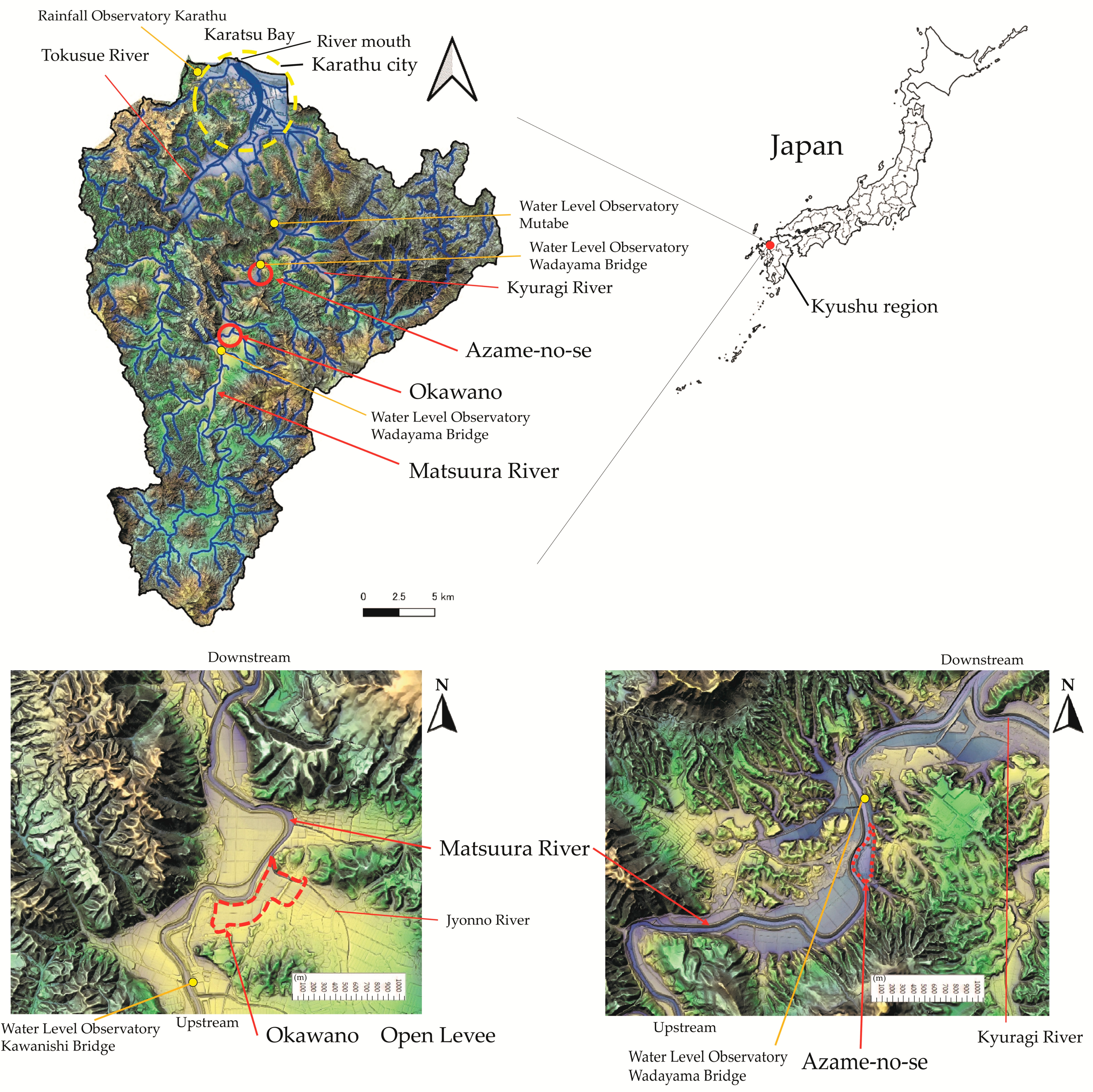
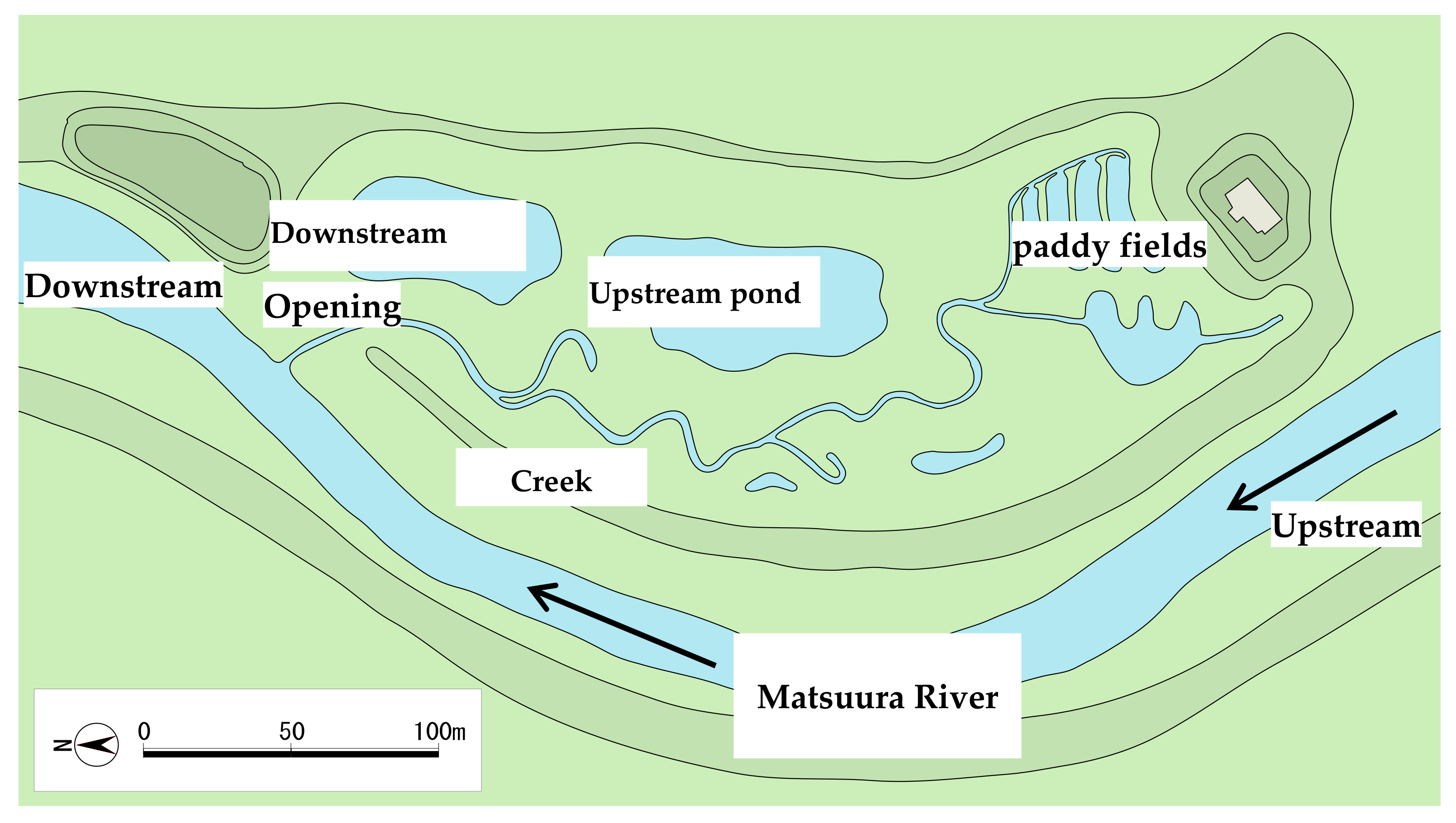
2.1. Research Sites


| Matsuura River | Flow Regime | ||||
|---|---|---|---|---|---|
| Length of mainstream | 47 | km | Name of station | Mutabe | |
| Drainage area | 446 | km2 | Max flow | 1791.66 | m3/sec |
| Yearly averaged rainfall | 2100 | mm | 185 days (50%) flow | 5.53 | m3/sec |
| Population in the watershed | About 100,000 | people | 355 days (97%) flow | 2.08 | m3/sec |
| Land use | Yearly averaged discharge | 12.46 | m3/sec | ||
| Mountain and Forest | 84 | % | Basic flood discharge | 3800 | m3/sec |
| Farmland | 15 | % | Average river bed slope | ||
| Urban area | 1 | % | Downstream area | 1/3100 | |
| Midstream area | 1/1100 | ||||
| Upstream area | 1/350 | ||||
| Name of Station | Mutabe | Wadayama Bridge | Kawanishi Bridge | |||
|---|---|---|---|---|---|---|
| Site | Downstream of the Matsuura River | Downstream of Azame-no-se | Upstream of Okawano area | |||
| Start (year) | 1961 | 1958 | 1958 | |||
| Distance from estuary | 11.85 | km | 15.05 | km | 25.2 | km |
| Catchment area | 275 | km2 | 150 | km2 | 120 | km2 |
| Design water level (T.P.) | 8.59 | m | 11.4 | m | 21.86 | m |
| Design flood discharge | 2400 | m3/s | 1500 | m3/s | 1300 | m3/s |
| Open Levees in Okawano | Azame-no-se | |||
|---|---|---|---|---|
| Distance from estuary | 25 | km | 15.6 | km |
| Catchment area | 127 | km2 | 146 | km2 |
| Bed slope | 1/600 | 1/2700 | ||
| Slope in the open levee | 1/536 | |||
| Area | 0.16 | km2 | 0.06 | km2 |
| Water storage capacity | 378,203.0 | m3 | 341,584.7 | m3 |
| Name of the branch river | Jyonno River | |||
| Catchment area | 4.3 | km2 | ||
2.2. Method
2.2.1. Literature Survey
2.2.2. Flood Observations
2.2.3. Oral Interviews
3. Results
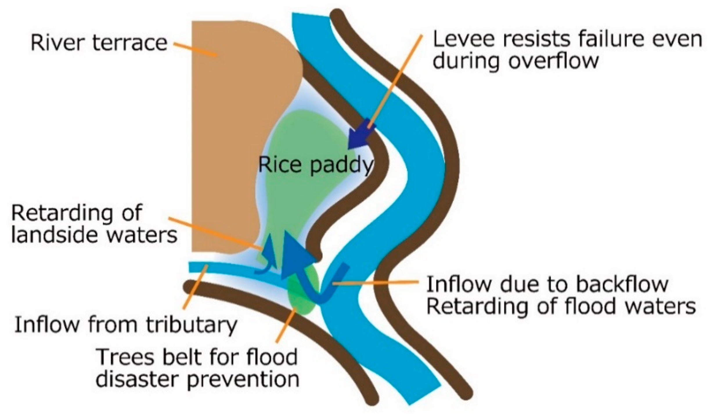
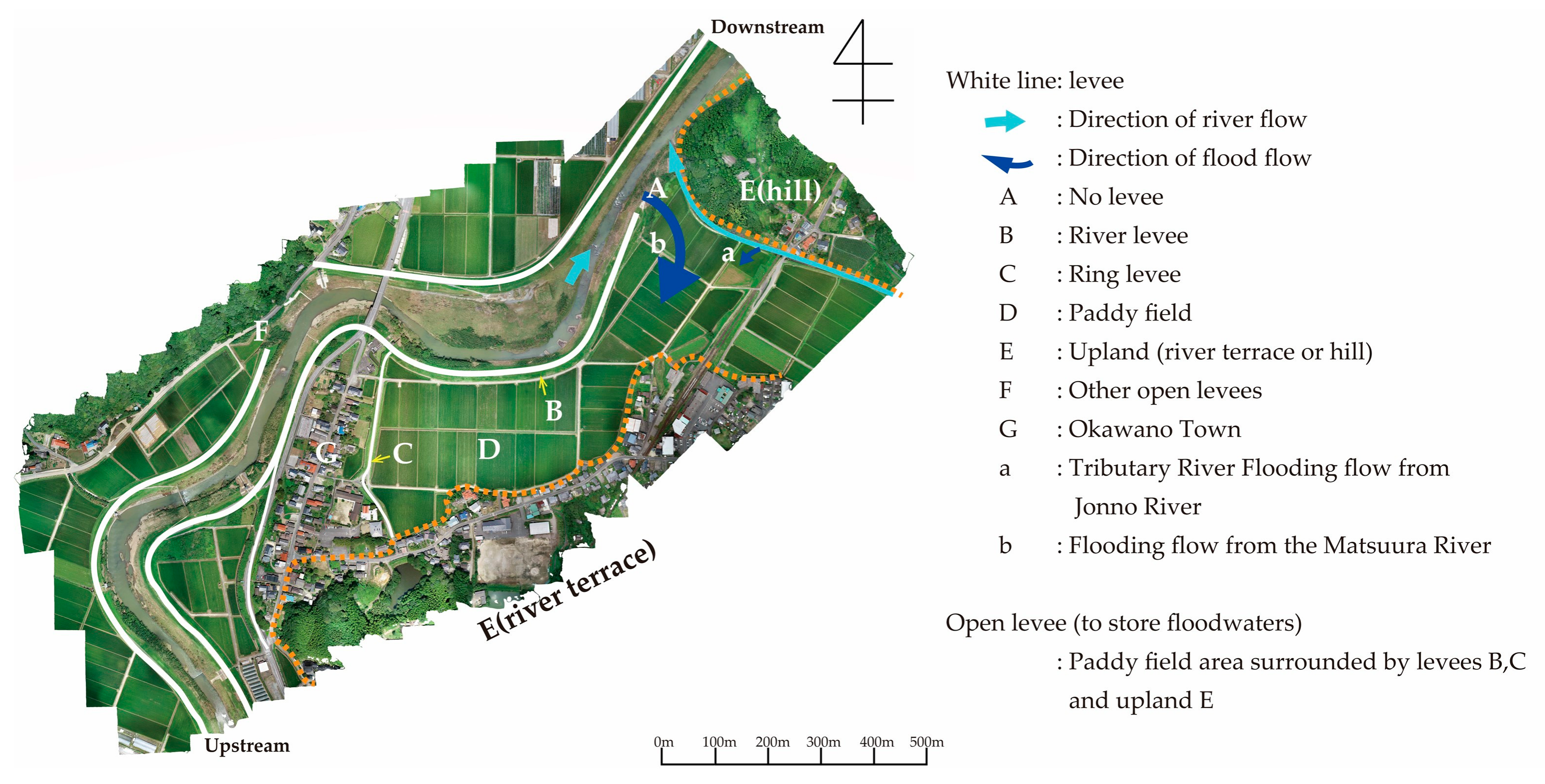
3.1. Open Levees in Okawano
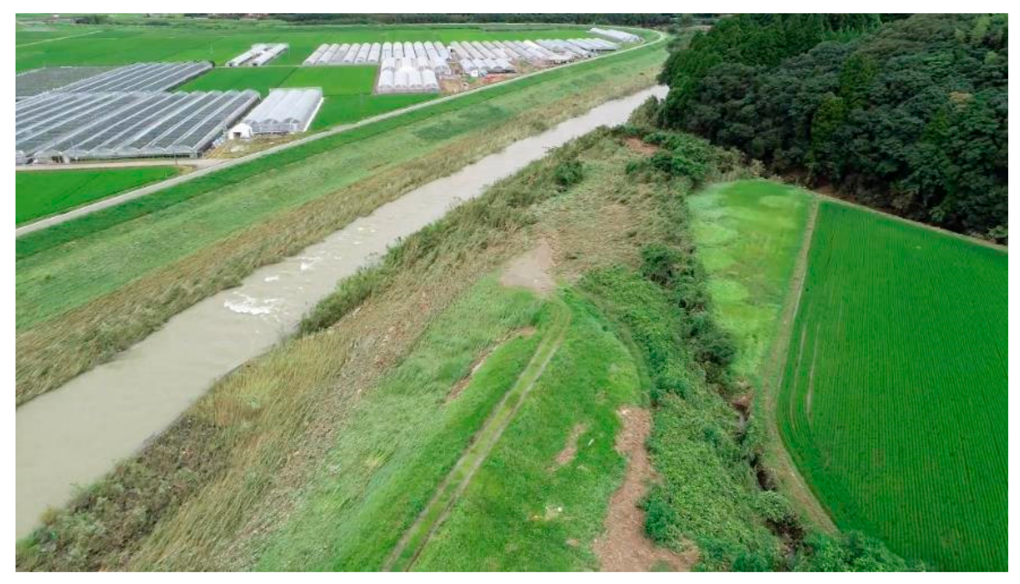
3.1.1. Overview
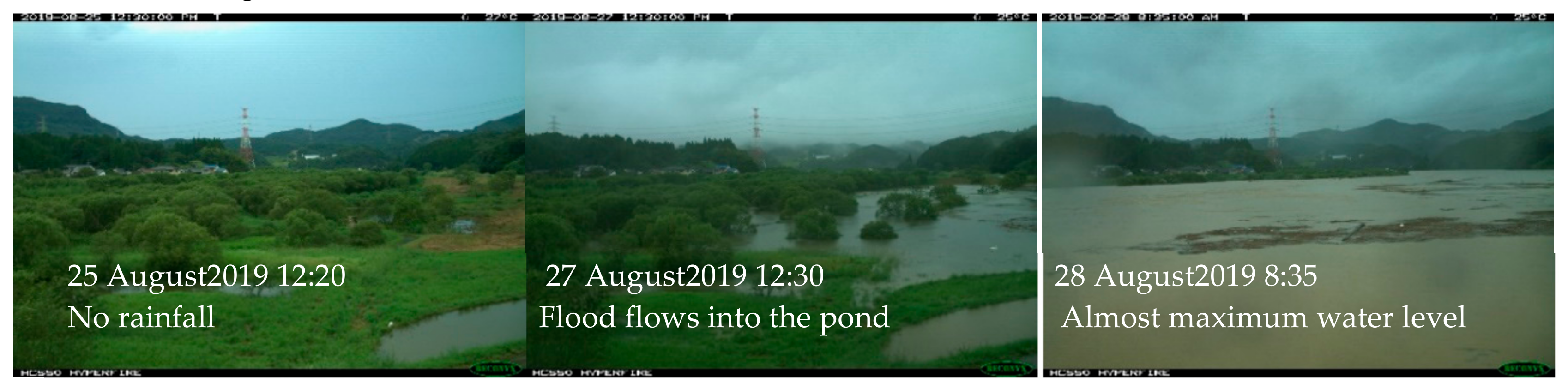
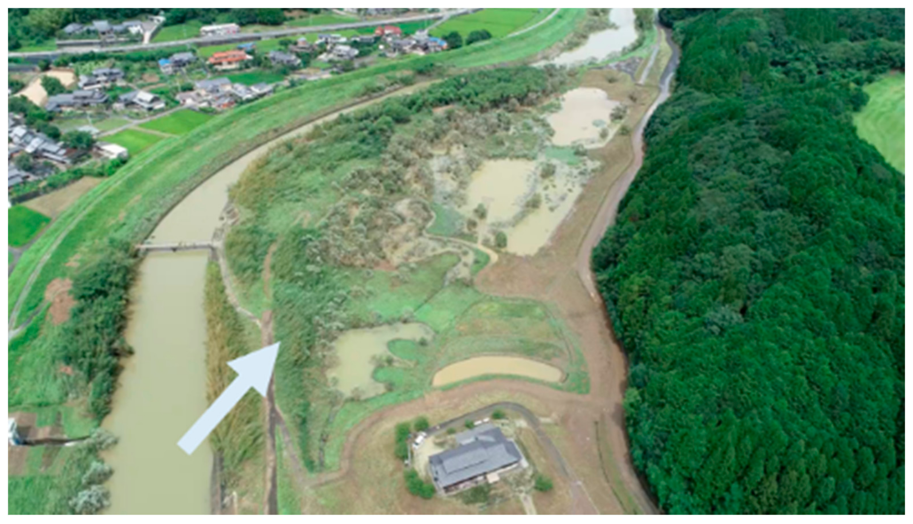
3.1.2. Flood on 28 August 2019
3.1.3. Interviews
- Results of interview with local archivist:
- -
- Okawano is an old lodging and post-station town dating back to 1705.
- -
- Levees have surrounded the town since ancient times.
- -
- The height of the river levees was approximately 1 m.
- -
- There has been no major flood disaster recently. In the 1990 flood, the houses (G) inside the ring levee (C) flooded above the floor level.
- -
- After the 1990 flood, the Ministry of Land, Infrastructure, Transport and Tourism raised the ring levee.
- -
- I am not sure about damage to farmland as I am not a farmer, but I do not recall any major damage.
- -
- The houses on the river terrace were built after the railroad was built. Before that, the entire town was inside the ring levee.
- -
- During the flood, the archivist went to the retarding basin to catch fish.
- Interview with farmer:
- -
- The 2019 rice harvest suffered almost no damage from the influx of floodwater. Other types of bad weather had a greater impact.
- -
- After the 1990 flood, the paddy fields did not flood again until 2019.
- -
- There was only minor damage to the paddy fields due to the bending of rice plants and the influx of debris and driftwood. Afterward, I had to go into the fields to remove the debris.
- -
- The soil becomes more fertile when the fields are submerged. Next year’s yields will be better.
- -
- The paddy fields on the downstream side are often submerged, but the upstream side is rarely submerged.
- -
- The rice plants need to be disinfected after being submerged because they become more susceptible to blight.
- -
- The water does not have much mud, and hence, adherence of mud to the rice plants after submergence is not a problem.
- -
- The fields are flooded for approximately a day.
- -
- When I was a boy, when water flowed into the open levee, I would go fishing there.
- -
- I would catch carp, catfish, and so on. I caught a big carp.
3.2. Azame-no-se
3.2.1. Overview
3.2.2. Flood on 28 August 2019
4. Discussion
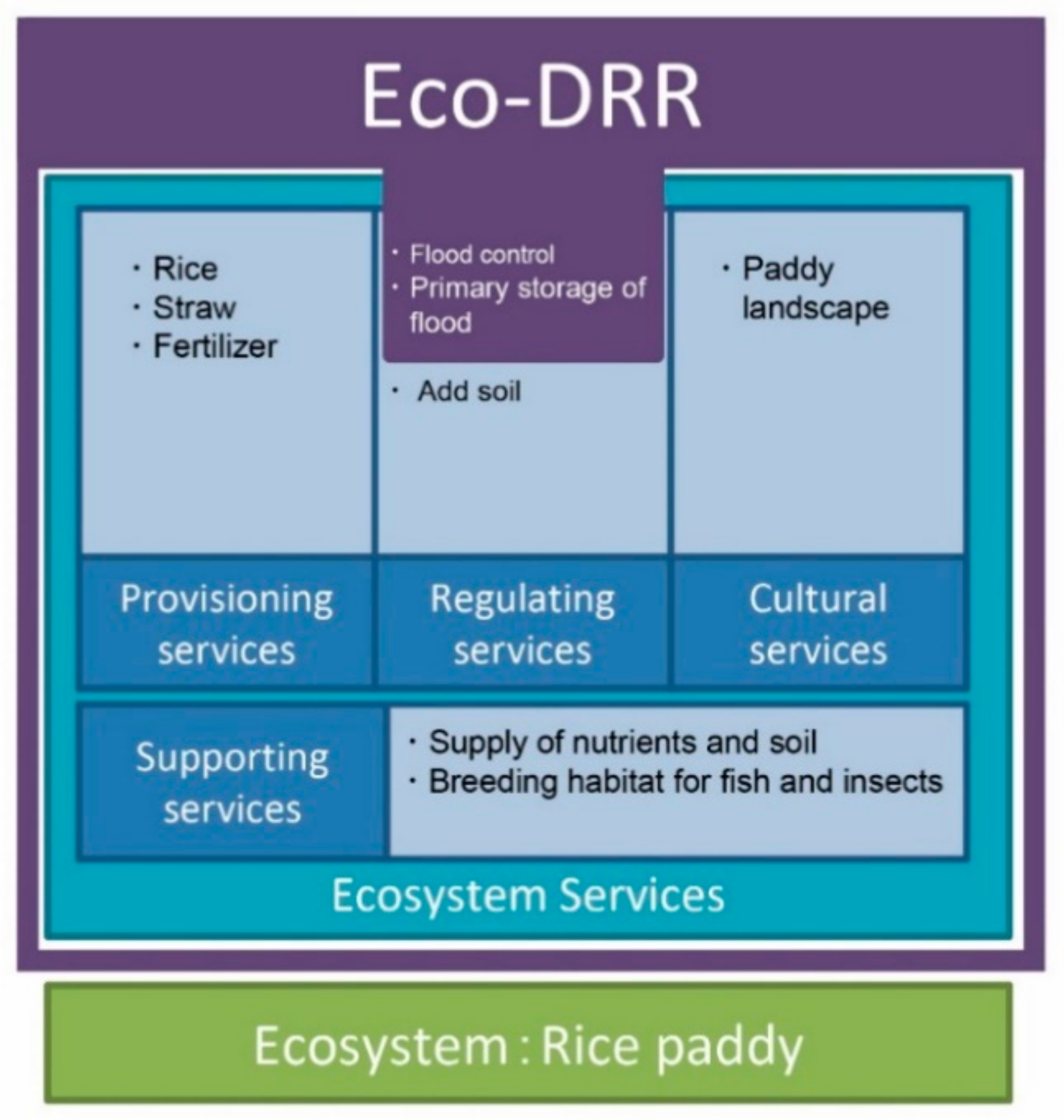
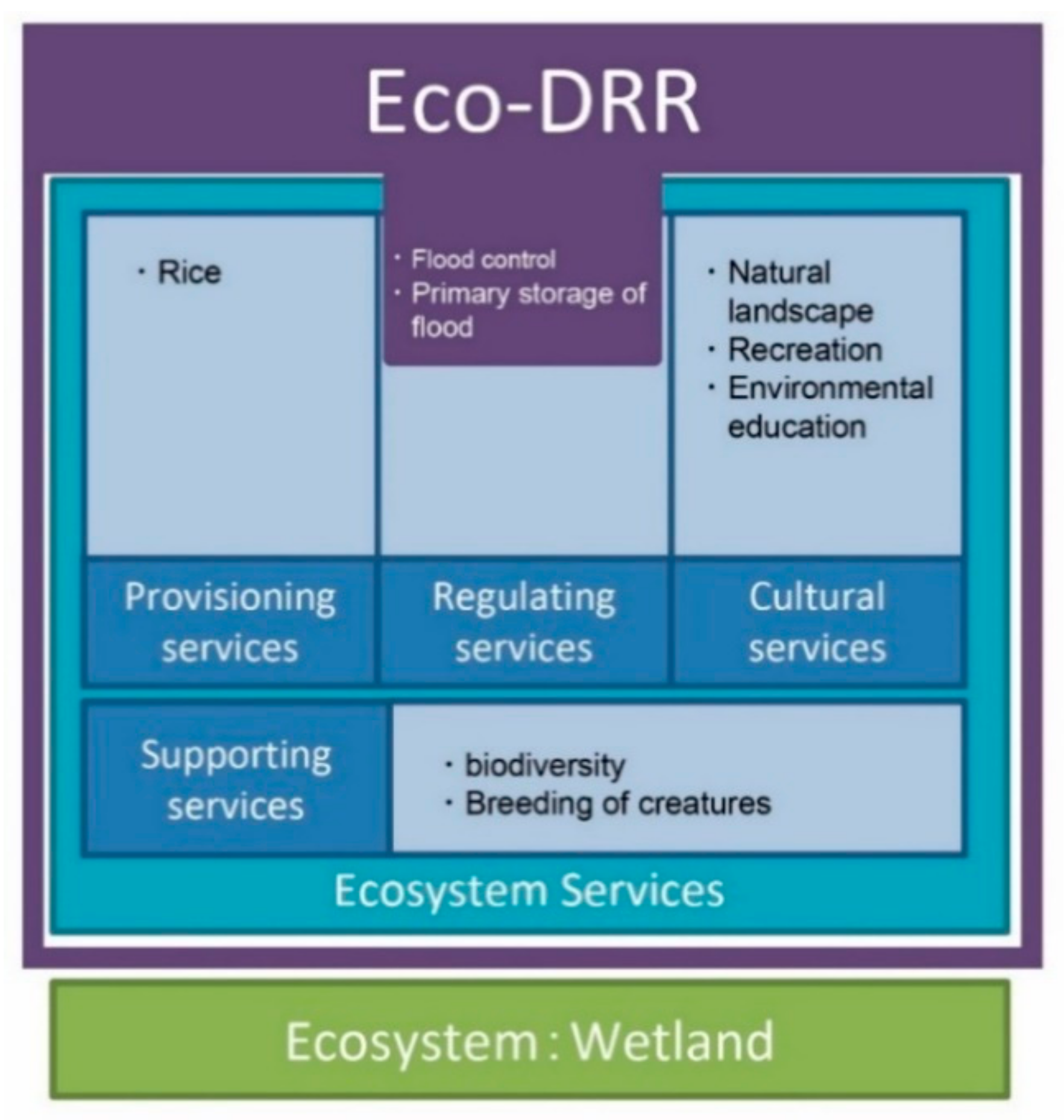
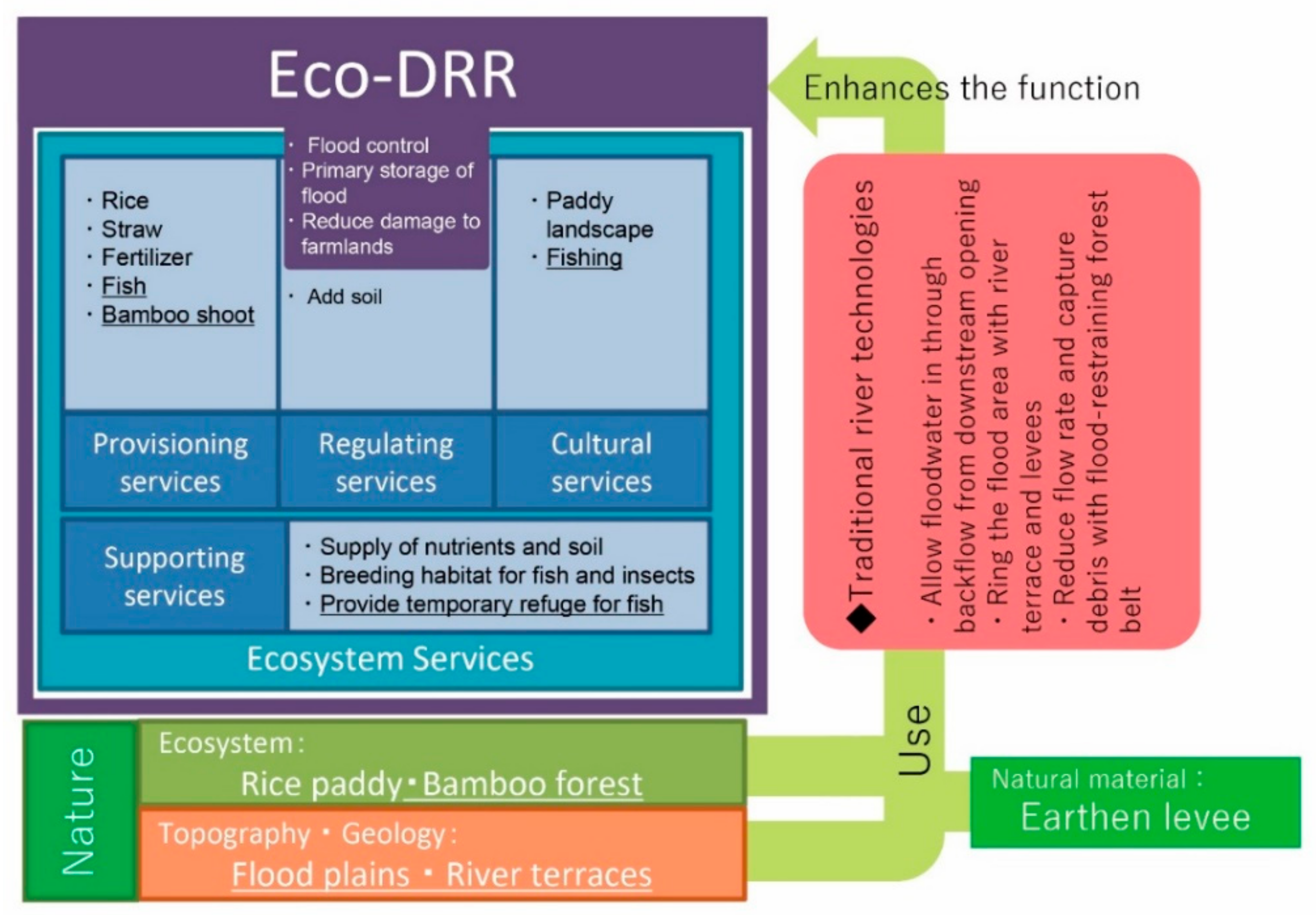
4.1. Eco-DRR Functions of Okawano Open Levee
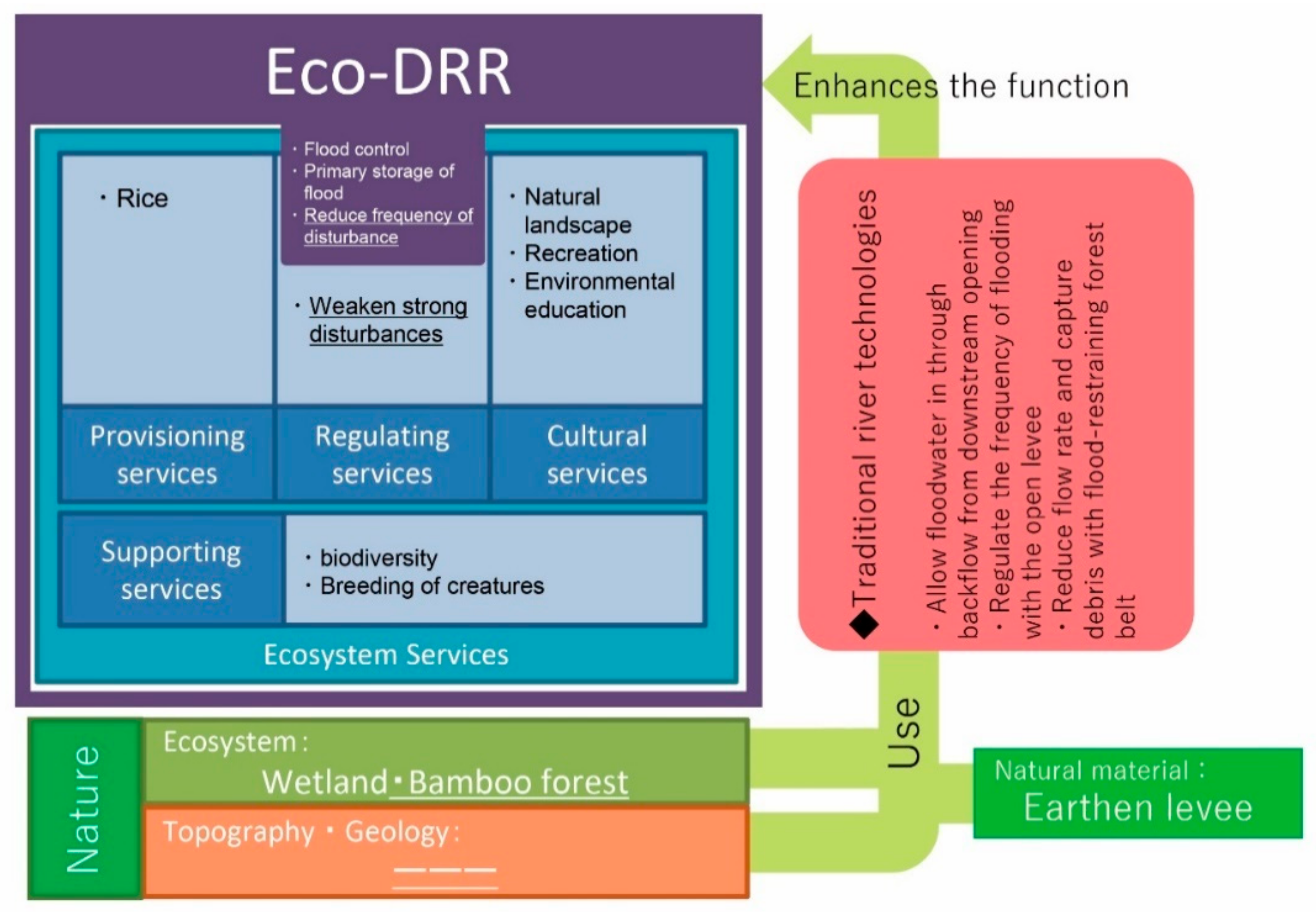
4.2. Eco-DRR Functions of Azame-no-se
4.3. Value in Terms of Construction Costs
4.4. Relationship between Ecosystem Services, Eco-DRR and Traditional River Technologies
4.5. Open Levees as an Eco-DRR System
5. Conclusions
Author Contributions
Funding
Institutional Review Board Statement
Informed Consent Statement
Data Availability Statement
Acknowledgments
Conflicts of Interest
References
- Brochure: Natural Disasters 2017, Centre for Research on the Epidemiology of Disasters (CRED). Available online: https://cred.be/sites/default/files/adsr_2017.pdf (accessed on 10 January 2021).
- Brochure: Economic Losses, Poverty & Disasters (1998–2017). Centre for Research on the Epidemiology of Disasters (CRED). Available online: https://www.cred.be/sites/default/files/CRED_Economic_Losses_10oct.pdf (accessed on 10 January 2021).
- Teramura, J.; Shimatani, Y. Quantifying Disaster Casualties Centered on Flooding in the Chikugo River Middle Basin in the Past 400 Years to Determine the Historical Context of the July 2017 Northern Kyushu Torrential Rainfall. J. Disaster Res. 2019, 14, 1014–1023. [Google Scholar] [CrossRef]
- Brochure: Sendai Framework for Disaster Risk Reduction 2015–2030. UNISDR. Available online: https://www.preventionweb.net/files/43291_sendaiframeworkfordrren.pdf (accessed on 10 January 2021).
- Furuta, N.; Shimatani, Y. Integrating ecological perspectives into engineering practices—Perspectives and lessons from Japan. Int. J. Disaster Risk Reduct. 2018, 32, 87–94. [Google Scholar] [CrossRef]
- Brochure: Ecosystem-based Disaster Risk Reduction in Japan—A Handbook for Practitioners. Available online: http://www.env.go.jp/nature/biodic/eco-drr/pamph04.pdf (accessed on 6 January 2021).
- Jong, P.; Brink, M.V.D. Between tradition and innovation: Developing Flood Risk Management Plans in the Netherlands. J. Flood Risk Manag. 2013, 10, 155–163. [Google Scholar] [CrossRef]
- Rautela, P. Traditional practices of the people of Uttarakhand Himalaya in India and relevance of these in disaster risk reduction in present times. Int. J. Disaster Risk Reduct. 2015, 13, 281–290. [Google Scholar] [CrossRef]
- Khalafzai, M.-A.K.; McGee, T.K.; Parlee, B. Flooding in the James Bay region of Northern Ontario, Canada: Learning from traditional knowledge of Kashechewan First Nation. Int. J. Disaster Risk Reduct. 2019, 36. [Google Scholar] [CrossRef]
- Cuaton, G.P.; Su, Y. Local-indigenous knowledge on disaster risk reduction: Insights from the Mamanwa indigenous peoples in Basey, Samar after Typhoon Haiyan in the Philippines. Int. J. Disaster Risk Reduct. 2020, 48. [Google Scholar] [CrossRef]
- Ahmad, B.; Alam, A.; Bhat, M.S.; Ahmad, S.; Shafi, M.; Rasool, R. Seismic risk reduction through indigenous architecture in Kashmir Valley. Int. J. Disaster Risk Reduct. 2017, 21, 110–117. [Google Scholar] [CrossRef]
- Teramura, J.; Takashi, O. A Study on evolution and role of open levees on alluvial-fran rivers in the Hokuriku Distrlct. J. Hist. Stud. Civ. Eng. 2005, 24, 161–171. [Google Scholar] [CrossRef]
- Teramura, J.; Takashi, O. A Study on Classification of Flood control function of Discontinuous levees. J. Hist. Stud. Civ. Eng. 2007, 26, 73–83. [Google Scholar] [CrossRef]
- Teramura, J. A study on function results of open levees when flood happened in Kurobe River. J. Hist. Stud. Civ. Eng. 2009, 28, 43–50. Available online: http://library.jsce.or.jp/jsce/open/00044/2009/28-0043.pdf (accessed on 22 December 2020).
- Senoo, H.; Ishikawa, T. Estimation of flood control function of Kasumi Levee System on the Kurobe Alluvial Fan in the Edo Era by numerical flow simulation. J. Jpn. Soc. Civ. Eng. B1 Hydraul. Eng. 2018, 74. [Google Scholar] [CrossRef]
- Hattori, S.; Nii, A. Topographical characteristics of location of sparse village at an alluvial fun. J. Jpn. Soc. Civ. Eng. D1 Archit. Infrastruct. Environ. 2012, 68, 35–44. [Google Scholar] [CrossRef]
- Nakashima, H.; Ohgushi, K.; Hino, T. Numerical simulations of flood and inundation for evaluating the effects of Nokoshi and open levee in Jobaru River. J. Jpn. Soc. Civ. Eng. B1 Hydraul. Eng. 2013, 69. [Google Scholar] [CrossRef] [Green Version]
- Doko, T.; Chen, W.; Sasaki, K.; Furutani, T. An attempt to develop an environmental information system of ecological infrastructure for evaluating func-tions of ecosystem-based solutions for disaster risk reduction (ECO-DRR). Int. Arch. Photogramm. Remote Sens. Spat. Inf. Sci. 2016, 8. [Google Scholar] [CrossRef] [Green Version]
- Dalimunthe, S.A. Who Manages Space? Eco-DRR and the Local Community. Sustainability 2018, 10, 1705. [Google Scholar] [CrossRef] [Green Version]
- Onuma, A.; Tsuge, T. Comparing green infrastructure as ecosystem-based disaster risk reduction with gray infrastructure in terms of costs and benefits under uncertainty: A theoretical approach. Int. J. Disaster Risk Reduct. 2018, 32, 22–28. [Google Scholar] [CrossRef]
- Gupta, A.K.; Nair, S.S. Ecosystem Approach to Disaster Risk Reduction; National Institute of Disaster Management: New Delhi, India, 2012; Available online: https://www.researchgate.net/profile/Sreeja_Nair10/publication/274640808_Ecosystem_approach_to_disaster_risk_reduction/links/5749639608ae2e0dd301703a/Ecosystem-approach-to-disaster-risk-reduction.pdf (accessed on 22 December 2020).
- Renaud, F.G.; Sudmeier-Rieux, K.; Estrella, M.; Nehren, U. Ecosystem-Based Disaster Risk Reduction and Adaptation in Practice; Springer International Publishing: Cham, Switzerland, 2016; Volume 42. [Google Scholar] [CrossRef]
- Brochure: Matsuura River Maintenance Plan, Kyushu Regional Development Bureau, MLIT. 2009. Available online: http://www.qsr.mlit.go.jp/takeo/matsuuragawa/seibikeikaku/seibikeikaku_03.html (accessed on 10 January 2021).
- Kashmir 3D. Available online: https://www.kashmir3d.com/ (accessed on 4 January 2021).
- Takeo Construction Office; Kyushu Regional Construction Bureau; Ministry of Construction. Takeo: 20 Years History of Takeo Construction; Kyushu Regional Construction Bureau: Fukuoka, Japan, 1979; p. 84.
- Japan River Association, Rivers in Japan. Available online: http://www.japanriver.or.jp/river_law/kasenzu/kasenzu_gaiyou/kyushu_r/094matsuura.htm.View (accessed on 10 January 2021).
- Ministry of Land, Infrastructure, Transport and Tourism. Water Information System. Available online: http://www1.river.go.jp/View (accessed on 10 January 2021).
- Okawa-cho History Compilation Committee. Okawa Town History; Okawa-cho onko-chisin-kai: Imari City, Japan, 1978; p. 15. [Google Scholar]
- Karatsu City History Compilation Committee. Karatsu City History; Karatsu City History Compilation Committee: Karatsu City, Japan, 1991. [Google Scholar]
- Imari City History Compilation Committee. Imari City History Early Modern and Modern Edition; Imari City History Compilation Committee: Imari City, Japan, 2007. [Google Scholar]
- Saga History Compilation Committee. Saga History Middle Volume; Saga Prefecture: Saga, Japan, 1974. [Google Scholar]
- The Committee of Azame-no-se. A Record of Azame-no-se; Kyushu Regional Development Bureau, MLIT: Karatsu City, Japan, 2011.
- Kyushu Regional Development Bureau, MLIT. Rokkaku River Water System Mutanabe Retarding dasin Project Ex-Post Evaluation Explanatory Material; Kyushu Regional Development Bureau: Takeo City, Japan, 2006.
- Damage Caused by Heavy Rainfall Accompanying the Front in August 2019—15th Report-Cabinet Office. Available online: http://www.bousai.go.jp/updates/r18gatuoame/pdf/r1_8gatuoame_15.pdf (accessed on 10 January 2021).
- Landscape & Design Committee; JSCE. Civil Engineering Design Prize, JSCE, Selected Works 2017 Azamenose Wetland Regeneration; Japan Society of Civil Engineers (JSCE): Tokyo, Japan, 2017. [Google Scholar]
- Geographical Survey Institute (GSI). GSI Maps Imari (1/50000); GSI: Tsukuba City, Japan, 1945. [Google Scholar]
- GSI. Aerial Photograph (USA-M663-11); GSI: Tsukuba City, Japan, 1947. [Google Scholar]
- GSI. Aerial Photograph (CKU773-C20C-17); GSI: Tsukuba City, Japan, 1977. [Google Scholar]
- Hayashi, H.; Shimatani, Y.; Shigematsu, K.; Nishihiro, J.; Ikematsu, S.; Kawaguchi, Y. A study of seed dispersal by flood flow in an artificially restored floodplain. Landsc. Ecol. Eng. 2012, 8, 129–143. [Google Scholar] [CrossRef]
- Hayashi, H.; Shimatani, Y.; Kozaki, K.; Ikematsu, S.; Tsujimoto, Y. A study about hydraulic characteristics of Unionoida under flowing water. J. Jpn. Soc. Civ. Eng. B1 Hydraul. Eng. 2011, 67, I_1393–I_1398. [Google Scholar] [CrossRef] [Green Version]
- Hayashi, H.; Inaguma, Y.; Otsubo, H.; Jia, L.; Shimatani, Y. A case study of flood disturbance impact on habitat of fresh water mussels. J. Jpn. Soc. Civ. Eng. G Environ. Res. 2015, 71, II_163–II_169. [Google Scholar] [CrossRef]
- Kozaki, K.; Hayashi, H.; Tsujimoto, Y.; Shimatani, Y. A case study of water quality fluctuations in an artificially restored floodplain. J. Jpn. Soc. Civ. Eng. Ser. B1 Hydraul. Eng. 2012, 68, I_613–I_618. [Google Scholar] [CrossRef]
- Hayashi, H.; Shimatani, Y.; Kozaki, K.; Ikematsu, S.; Tsujimoto, Y.; Miyajima, Y.; Agata, M.; Suzuki, T.; Soeda, M.; Kawahara, T. A Comprehensive Report of Activities and Monitoring Conducted in the Azame-no-se Floodplain Restoration Project. Wetl. Res. 2012, 2, 27–38. [Google Scholar] [CrossRef]
- Inaguma, Y.; Hayashi, H.; Tsujimoto, Y.; Shimatani, Y. Settling Caracteristics and the limiting factor of habitat distribution of Unionoida mussels in the Matsuura River. J. Jpn. Soc. Civ. Eng. Ser. B1 Hydraul. Eng. 2013, 69. [Google Scholar] [CrossRef] [Green Version]
- Watanabe, K.; Hirakawa, R. Effects of flood plain on main channel with flood flow of the Matsuura River. Hydraul. Eng. J. Jpn. Soc. Civ. Eng. 2007, 51, 673–678. [Google Scholar] [CrossRef]
- Tomita, R. The Possibilities of ‘Temporary Consent’ in Collaboration toward Environmental Conservation: A Case Study of the Nature Restoration Project at Azame-no-Se Articles. J. Environ. Sociol. 2010, 16, 79–93. [Google Scholar] [CrossRef]
- Teramura, J.; Kitamura, K.; Shimatani, Y. Functional evaluation of open levees in the Okawano area of the Matsuura River. Annu. J. Hydraul. Eng. 2020, 65, 445–450. [Google Scholar]
- Source: Water level data, Wadayamabashi. Available online: http://www1.river.go.jp/cgi-bin/SiteInfo.exe?ID=309021289903030View (accessed on 10 January 2021).
- Saito, K. Movement and spawning of several freshwater fishes in temporary waters around paddy fields. Jpn. J. Ecol. 1988, 38, 35–47. [Google Scholar]
- Natuhara, Y. Ecosystem services by paddy fields as substitutes of natural wetlands in Japan. Ecol. Eng. 2013, 56, 97–106. [Google Scholar] [CrossRef]
- Ministry of the Environment Government of Japan Nature Conservation Bureau. Ecosystem-Based Disaster Risk Reduction in Japan–A Handbook for Practioners; Ministry of the Environment Government of Japan: Tokyo, Japan, 2016. Available online: https://www.env.go.jp/nature.biodic.eco-drr/pamph01.pdf (accessed on 10 January 2021).
- IUCN. Environmental Guidance Note for Disaster Risk Reduction. 2013. Available online: https://www.iucn.org/sites/dev/files/content/documents/2013_iucn_bookv2.pdf. (accessed on 10 January 2021).


| No | Title | Class | Source/Publisher | Issue Date | References No |
|---|---|---|---|---|---|
| 1 | Okawa Town History | Local history documents | Okawa-cho onko-chisin-kai | 1978 | [28] |
| 2 | Karatsu City History | Local history documents | Karatsu City | 1964 | [29] |
| 3 | Imari City History Early Modern and Modern Edition | Local history documents | Imari City | 2007 | [30] |
| 4 | Saga history middle volume | Local history documents | Saga Prefecture | 1968 | [31] |
| 5 | A record of Azame-no-se | Reports | Kyushu Regional Development Bureau, MLIT | 2011 | [32] |
| 6 | Matsuura River maintenance plan | Administrative documents | Kyushu Regional Development Bureau, MLIT | 2009 | [23] |
| 7 | Rokkaku River Water System “Mutanabe” retarding basin construction Project Ex-post evaluation, Explanatory material | Administrative documents | Kyushu Regional Development Bureau, MLIT | 2006 | [33] |
| 8 | Damage Caused by Heavy Rainfall Accompanying the Front in August 2019-15th Report | Administrative documents | Cabinet Office | 2019 | [34] |
| 9 | CIVIL ENGINEERING DESIGN PRIZE, JSCE, Selected Works 2017 | Reports | Japan Society of Civil Engineers (JSCE) | 2017 | [35] |
| 10 | GSI Maps Imari (1/50000) (1945) | Maps | Geographical Survey Institute | 1945 | [36] |
| 11 | Aerial photograph (USA-M663-11) | Aerial photograph | Geographical Survey Institute | 1947 | [37] |
| 12 | Aerial photograph (CKU773-C20C-17) | Aerial photograph | Geographical Survey Institute | 1977 | [38] |
| 13 | A study of seed dispersal by flood flow in an artificially restored floodplain. | Full Paper | Landscape and ecological engineering 8.2 | 2012 | [39] |
| 14 | A Study about hydraulic characteristics of unionoida under flowing water. | Full Paper | Journal of Japan Society of Civil Engineers, Ser. B1 (Hydraulic Engineering) 67 | 2011 | [40] |
| 15 | A CASE STUDY OF FLOOD DISTURBANCE IMPACT ON HABITAT OF FRESH WATER MUSSELS | Full Paper | Journal of Environmental Systems Research, Vol.43 | 2015 | [41] |
| 16 | A case study of water quality fluctuations in an artificially restored floodplain | Full Paper | Journal of Japan Society of Civil Engineers, Ser. B1 (Hydraulic Engineering) 68.4 | 2012 | [42] |
| 17 | A Comprehensive Report of Activities and Monitoring Conducted in the Azame-no-se Floodplain Restoration Project. | Review | Wetland research 2 | 2012 | [43] |
| 18 | Settling characteristics and the limiting factor of habitat distribution of unionoida mussels in the Matsuura River | Full Paper | Journal of Japan Society of Civil Engineers, Ser. B1 (Hydraulic Engineering) 69 | 2013 | [44] |
| 19 | EFFECTS OF FLOOD PLAIN ON MAIN CHANNEL WITH FLOOD FLOW OF THE MATSUURA RIVER | Full Paper | PROCEEDINGS OF HYDRAULIC ENGINEERING 51 | 2007 | [45] |
| 20 | The Possibilities of ‘Temporary Consent’ in Collaboration toward Environmental Conservation: A Case Study of the Nature Restoration Project at Azame-no-Se | Full Paper | Journal of Environmental Sociology. Volume 16 | 2010 | [46] |
| 21 | FUNCTIONAL EVALUATION OF OPEN LEVEES IN THE OKAWANO AREA OF THE MATSUURA RIVER | Full Paper | Journal of Japan Society of Civil Engineers, Ser. B1 (Hydraulic Engineering) 76.2 | 2020 | [47] |
| Subject | Local Archivist | Farmers |
|---|---|---|
| Method of selection | Introduction from Imari City | Introduction from a local historian |
| Reasons for selection | Knowledgeable about the history and local community of the Okawano area | Owner of the paddy field in the open levee |
| Date | 21 July 2019 | 28 November 2019 |
| Place | Subject’s home | Subject’s garden |
| Method | Oral Interviews | Oral Interviews |
| Contents | Local history, flood experience, expansion of residential areas, height of ring levees, flood control activities, function of open levees, frequency of flooding, impact on agricultural revenue, behavior at the time of flooding, fish catching, and species of living things | About the current disaster, frequency of flooding in paddy fields, amount of damage caused by flooding, impact on rice, inflow of garbage, inflow of sediment, rice disease, thoughts as a farmer, catching fish, and behavior at the time of flooding |
| Flood Event | |||
|---|---|---|---|
| Date | 26–29 August 2019 | ||
| Flood damage to houses: | 29 | ||
| Inundation area | 1.82 km2 | ||
| Rainfall Observatory | |||
| Name of station | Karathu | ||
| Site | Near the mouth of Matsuura River | ||
| Amount of rainfall (During the period) | 533 | mm | 2nd largest in recorded history |
| Amount of rainfall (48 h) | 422 | mm | Largest in recorded history |
| Water Level Observatory | |||
| Name of station | Kawanishi Bridge | ||
| Site | Upstream of Okawano area | ||
| Design water level (T.P.) | 21.86 | m | |
| Design flood discharge | 1300 | m3/s | |
| Max water level for the event (T.P.) | 21.88 | m | 3rd largest in recorded history |
| Max flood discharge for the event | 1110.64 | m3/s | |
| Name of station | Wadayama Bridge | ||
| Site | Downstream of Azame-no-se | ||
| Design water level (T.P.) | 11.4 | m | |
| Design flood discharge | 1500 | m3/s | |
| Max water level for the event (T.P.) | 11.18 | m | 4th largest in recorded history |
| Location | Okawano | Azame-no-se | Mutabe Retarding Basin | |
|---|---|---|---|---|
| Water level (elevation) | m | 19.1 | 12.0 | |
| Area | m2 | 209,135.5 | 60,745.0 | 534,000.0 |
| Volume | m3 | 378,203.0 | 341,584.7 | 900,000.0 |
| Water storage per unit area | m3 | 1.81 | 5.62 | 1.69 |
| Construction cost | billion yen | free | 0.8 | |
| Percentage of water storage compared with the Mutabe retarding basin | % | 42.0 | 38.0 | 100.0 |
| Estimated cost based on the construction cost of the Mutabe retarding basin | billion yen | 4.7 | 4.2 |
Publisher’s Note: MDPI stays neutral with regard to jurisdictional claims in published maps and institutional affiliations. |
© 2021 by the authors. Licensee MDPI, Basel, Switzerland. This article is an open access article distributed under the terms and conditions of the Creative Commons Attribution (CC BY) license (http://creativecommons.org/licenses/by/4.0/).
Share and Cite
Teramura, J.; Shimatani, Y. Advantages of the Open Levee (Kasumi-Tei), a Traditional Japanese River Technology on the Matsuura River, from an Ecosystem-Based Disaster Risk Reduction Perspective. Water 2021, 13, 480. https://doi.org/10.3390/w13040480
Teramura J, Shimatani Y. Advantages of the Open Levee (Kasumi-Tei), a Traditional Japanese River Technology on the Matsuura River, from an Ecosystem-Based Disaster Risk Reduction Perspective. Water. 2021; 13(4):480. https://doi.org/10.3390/w13040480
Chicago/Turabian StyleTeramura, Jun, and Yukihiro Shimatani. 2021. "Advantages of the Open Levee (Kasumi-Tei), a Traditional Japanese River Technology on the Matsuura River, from an Ecosystem-Based Disaster Risk Reduction Perspective" Water 13, no. 4: 480. https://doi.org/10.3390/w13040480