
Rapid River Bed Recovery after the In-Channel Mining: The Case of Vistula River, Poland


Institute of Earth Sciences, Faculty of Natural Sciences, University of Silesia in Katowice, Będzińska 60, 41-200 Sosnowiec, Poland
*
Author to whom correspondence should be addressed.
Water 2021, 13(5), 623; https://doi.org/10.3390/w13050623
Submission received: 28 January 2021
/
Revised: 18 February 2021
/
Accepted: 23 February 2021
/
Published: 27 February 2021
(This article belongs to the Section Water Erosion and Sediment Transport)
Abstract
:The effects of in-channel wet-pit mining is nowadays widely discussed in terms of negative influence of the created pits on the river ecosystem and fluvial processes. The pits induce an alteration of natural flow or sediment transport. This paper describes the post-mining channel recovery observed in a relatively short time in a gravelly sand bed lowland river. The study was based on repeated bathymetry of the channel and grain size analyses of bed material taken from the mining area and its surrounding upstream and downstream pit. We also use calculations of possible bedload sediment movement in the studied river reach. We noticed that the excavation pit exceeded the maximum depth of 8.8 m in 2014 and, immediately after the end of mining, the bedload started to infill the pit. The bathymetric measurements in 2019 indicated that the process of pit infill was completed after five years, though the former pit is refilled with material finer than the natural bedload observed in the discussed river reach, and consists mainly of sand. The studied process of pit infilling runs continuously, even during the annual average water stages.
1. Introduction
In-channel mining always induces changes in natural fluvial processes. The observed effects include disturbance of the sediment transport balance, changes in the geometry of the river channel, activation or intensification of channel incision, changes in the fractional composition of sediments, deepening of the river channel, changes in channel roughness, and acceleration of flow [1,2,3], which, in a complex way, lead to significant changes in the freshwater ecosystem [4]. As a result of in-stream sediment extraction, the natural riverbed pavement that protects the base of the channel from excessive degradation is destroyed. River regulatory structures and bridge supports are also damaged and undercut [5,6,7]. These effects can be observed near exploitation sites upstream and downstream over time, and, in some cases, even in tributaries, as the rapid incision of the main watercourse means lowering the base level [8,9,10].
The intensity of the effects of in-stream extraction varies depending on the method, resistance of the channel to erosion, hydrological conditions, and sediment transport budget [11,12]. Rapid changes in morphology attributed to massive floods are primarily the result of the weakening of channel stability by extraction, and this facilitates its remodeling during high water levels. In a channel with a complex bed relief, the distribution of hydraulic energy and tangential stresses is diversified, and this causes a specific distribution of the sediment. In places with higher energy, material with larger fractions is deposited, and in shallower sections, fine-grained material is deposited [13]. During the transport of material along the river bed, it is sorted according to size, with the smallest penetrating deeply into the sediment mass of larger fractions and immobilized there [6,14]. This is the lining of the river bed. During in-stream extraction, this system is disturbed, and fine material is reintroduced into the system, causing the water to become turbid and, in the longer term, the enrichment of sediments with clay fractions downstream. The moment that initiates a series of morphological consequences within the river channel happens at the start of in-stream extraction.
Geomorphological research shows that the depressions formed in the channel bed constitute a trap for the material transported by the river and that these zones break the continuity of fluvial transportation. According to Barman et al. [15], Galay [8], Kondolf [1,9], Krzemień [16], Marston et al. [17], and Rinaldi et al. [12], after in-stream extraction ends, the upstream edge of the excavation trough migrates further upstream. The water energy released is also directed to incision downstream of the excavation. Long-term sediment extraction in the Polish Carpathians accelerated the deepening of river channels, and has led to the exposure of bedrock [5,17]. In regulated river channels, the alluvial base becomes the only sediment supplier, and an increase in the rate of incision there causes the lowering of the bed and damage to the support of engineering structures [6,17]. The channel’s reaction to gravel extraction lasts from 15 to 30 years, and depends on its duration [12]. In the case of the rivers described in the literature, incision caused by the exploitation of sediments occurs at a rate of 0.1 to 0.4 m per year [12]. The case of Cache Creek in California is cited by Kondolf [9] as an example of the upstream migration mechanism. In four years, the threshold of the 3 m deep excavation moved about 1.5 km, weakening the structure of a road bridge. In Russian Creek, also in California, incision downstream of the excavation caused the bed to be lowered by 3 to 6 m over a distance of 11 km. River channel incision is often described in the literature as a result of sediment exploitation, and maximum values of up to 14 m have been observed in France, Italy, and Northern England [12].
This phenomenon is also common in Poland, especially in the rivers in the southern, mountainous part of the country. Within 25 years of the commencement of in-stream extraction in the Ropa at Biecz, its bed has dropped by 1.5 m down to the bedrock [18], and the Wisłoka river channel in Łabuz, for the same reason, dropped by about 4 m in nine years [10]. River engineering can also initiate incision processes. An example is the Skawa and Wisłoka rivers, the beds of which were lowered by a few meters, while there was also a change in their nature from alluvial to rocky [19].
Very little research reports the field-studied channel recovery after mining ends [20,21,22], but many experimental studies of wet pit evolution have been conducted both as laboratory experiments [23,24,25] or computational models [26,27]. Laboratory experiments were conducted under equilibrium and non-equilibrium sediment transport conditions [23,24]. The results of both types of experiments suggested the downstream degradation of the in-channel pit.
Cao et al. [25] raised the problem of modelling the sediment mining and feeding, and indicated the need for a quantitative understanding of such an interaction. Although Cao et al. [25] doubt that sediment mining and feeding may occur simultaneously in practice, the case study presented in our paper seems to partly exemplify these specific conditions.
The main purpose of this article is to present the interaction between changes in the morphometry of the Vistula channel under diversified anthropopressure and the natural processes of sediment transport. For this reason, two main research goals were formulated. The first was to determine changes in the morphometric parameters of the river channel during wet pit mining (2012–2015) and after it (2016–2019). The second goal was to determine the pathway of river channel recovery within a few years.
2. Materials and Methods
2.1. Study Site
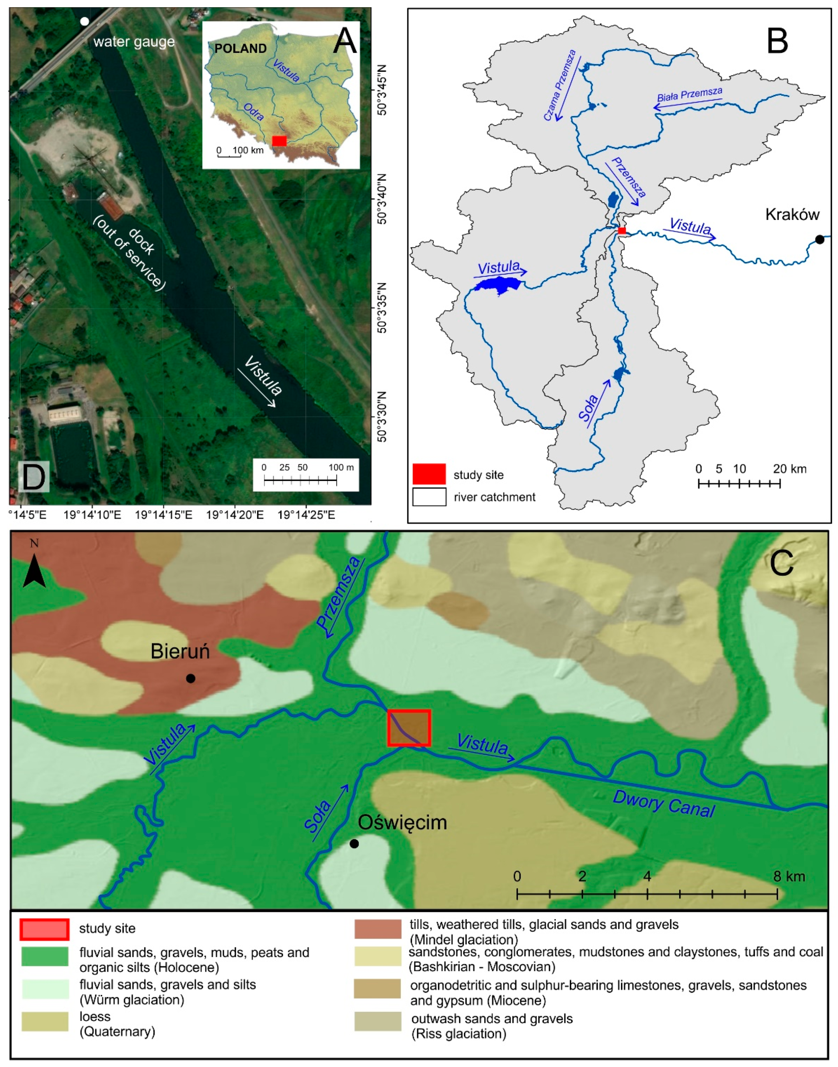
The Vistula is the largest Polish river, with a total catchment area of about 194,500 km2 (Figure 1A). The study site is located on the foreland of the Western Carpathians, in the upper course of the Vistula at 107 km from its source immediately downstream the confluence of the Vistula and the Przemsza rivers (Figure 1B). Up to this point, the Vistula and the Przemsza catchments cover, respectively, areas of 1789 km2 and 2121 km2.
At the Pustynia gauging station (Figure 1D), the observed discharges of the Vistula oscillate between 603 m3/s and 18.4 m3/s. An average discharge equals 44.4 m3/s (24.4 m3/s is the Vistula average discharge upstream the Przemsza confluence). An average discharge of the Przemsza equals 20 m3/s. The last flood of the Vistula was recorded in 2010. The Vistula channel slope in the discussed location is 0.38 m/km.
During the first decade of the twentieth century, in the study site, the Vistula channel was engineered, and the banks reinforced with fascines and crushed stones. The groins were constructed to protect the banks from side erosion. In this section, the Vistula channel is 40 m wide, while the inter-embankment zone is 250–280 m wide and gravel-bottomed, which is type 13 according to the classification of Rinaldi et al. [12].
The Vistula valley is filled with Holocene sandy sediments (Figure 1C) underlined with Carpathian gravels, which are the subject of exploitation [28]. The extraction of the raw material was carried out using underwater dredging from anchored barges.
In-stream extraction of sediments in the Vistula channel was carried out immediately downstream from the dock, which is out of operation (Figure 1D). In the 1970s, this dock was planned as part of a waterway, also including the Dwory Canal, which bypasses the Vistula and meanders a few kilometres to the east (Figure 1C). Between the dock and the canal, the Vistula channel is artificially widened up to 60 m for navigational purposes.
2.2. Bathymetric Survey and Sampling
Measurements of the morphometric parameters of the Vistula channel were made during gravel extraction (November 2012 and August 2014) and after it ended (August 2017, August 2018, and October 2019). The tests were carried out with the Lowrance HDS-5 GEN2 echosounder integrated with GPS and attached to a pontoon powered by an electric motor. The research technique consisted of carrying out measurements in such a way that a lattice arrangement of profiles was created. During measurements, for each signal (pulse) sent by the echo sounder, information about depth, longitude, and latitude was recorded, which is a widely used technique that allows for the precise imaging of the beds of rivers and lakes [29,30].
The results of these measurements made it possible to draw bathymetric plans of this section of the Vistula channel. They were developed using ArcMap 10.2.1, and this was also used to plot the transverse and longitudinal profiles and to calculate the morphometric parameters of the excavation. As a way of ensuring comparability, bathymetric measurements were made at times when water levels at the Pustynia gauging station were similar, and amounted to 220 ± 1 cm.
2.3. Grain Size Analysis
Analysis of the fractional composition of sediments on the Vistula riverbed was performed based on samples collected, and their sites are shown in Figure 2. The sediment samples were collected using a Van Veen grab sampler, and were air-dried, after which a fractional composition analysis was performed using the standard sieve method.
2.4. Particle Initial Motion Calculation
To calculate the initiation of motion of grains backfilling the excavation, the dimensionless Shields parameter θ was calculated according to the formula:
where τ = shear stress, ρs = sediment density, ρ = water density, g = gravity, and D50 = mean particle diameter.
The shear stress τ in N/m2 was calculated as:
where ρ = water density, g = gravity, h = water depth, and S = channel slope.
τ = ρghS
The values of water and sediment density and gravity are constant (ρs = 2650 kg/m3, ρ = 1000 kg/m3, g = 9.8 m/s2). D50 is the median size of sediments infilling the pit after the cessation of mining.
Due to the diverse bottom morphology and hence the various values of the water depth in the channel cross profile, instead of water depth h, the hydraulic radius Rh was taken into consideration and calculated as:
where W = channel width and h = channel depth.
3. Results and Discussion
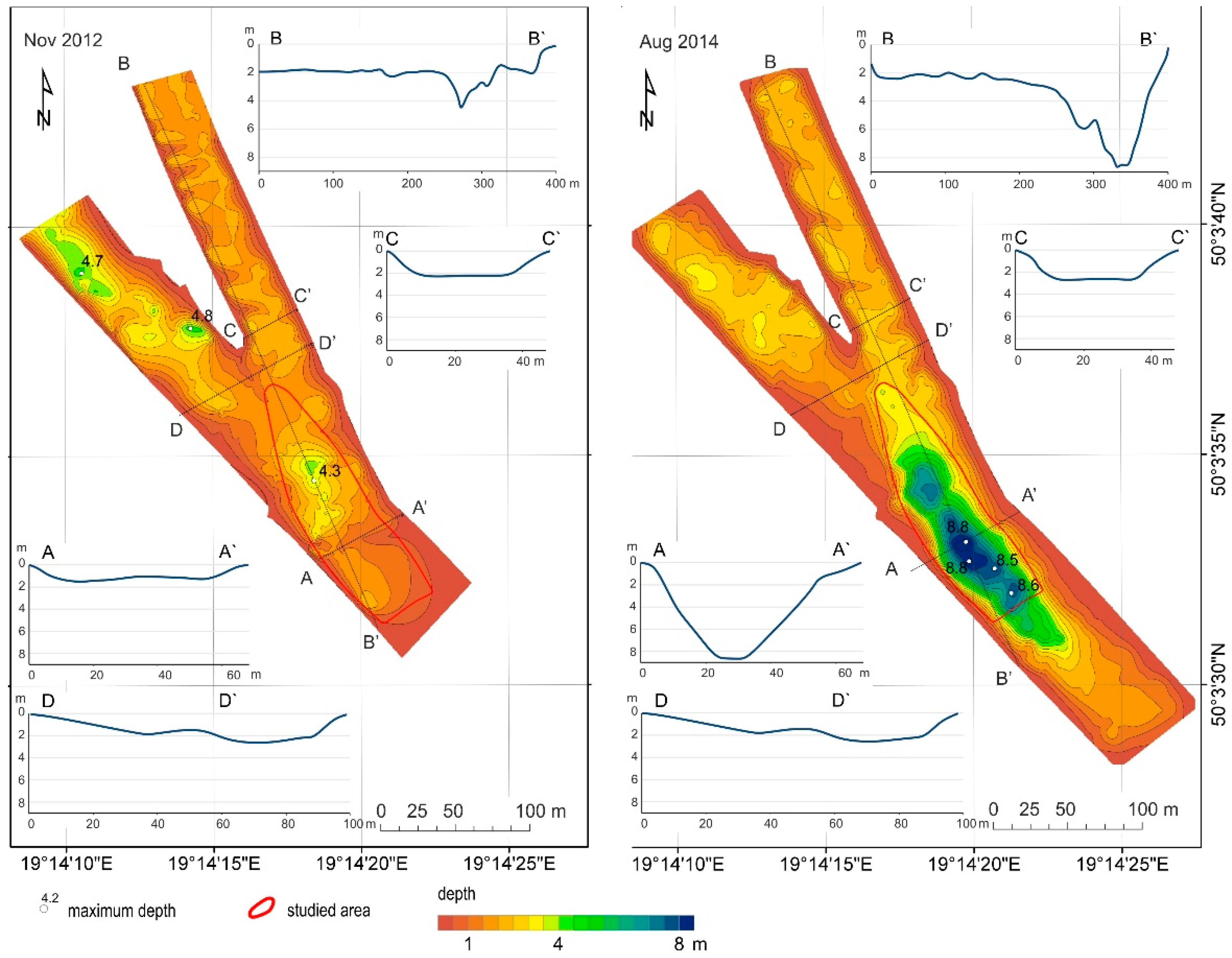
Bathymetry was made at the gravel extraction site in 2012, and again when its range and size reached its maximum in 2014, with plans for changes to its relief being prepared (Figure 3 and Figure 4). Analysis of these plans shows that the maximum depth of the excavation (8.8 m) was located in the central part of the Vistula channel. The plan of river depth differences in the exploitation zone shows the scale and range of changes in the channel bed in 2012–2014, and the prepared plans allow the parameters of the exploitation trough to be determined. In November 2012, its maximum depth was 4.3 m, and in August 2014, it was 8.8 m (Figure 3). The length of the trough also changed, while the width remained untouched: in 2012 it was 75 m long and 50 m wide, and in 2014, it was 255 m long and 50 m wide. The excavation volume increased significantly from 4385 m3 in 2012 to 32,148 m3 in 2014. It is also worth paying attention to changes in the shape and depth of the bed of the channel within the port basin (Figure 4), an artificial branch of the Vistula channel situated next to the in-stream extraction site. During the period of gravel exploitation, the port pool was subjected to intense shallowing, reaching a maximum of just 3 m, a consequence of the process of washing the gravel extracted from the channel bed and the discharge of fine fractions into the basin.
The research has allowed changes in the shape of the channel bed caused by in-stream extraction and the way it changed the fractional composition of the bedload in the Vistula channel to be documented. Sands are the youngest natural type of sediments lining the river bed in the section studied, and they occurred upstream of the excavation pit at sites 1 and 2 (Figure 5). During the exploitation in 2014, Carpathian gravels were exposed in the excavation zone at sites 3 and 4, and are visible in Figure 5 as the bimodal curves of grain size distribution.
In the autumn of 2015, in-stream extraction in the Vistula channel ceased, and since then, channel forms have been shaped through natural morphogenetic processes. Currently, the excavation has been filled with sand, with a dominant fraction in the range of 0.8–0.25 mm, the same type of sediment found in the Vistula riverbed upstream of the excavation (Figure 5). The share of fractions in the range of 0.5–0.25 mm is slightly higher, because its increase is influenced by the artificial widening of the river channel by the port basin: upstream of the excavation, the width of the Vistula channel is 40 m, but in the excavation zone, it rapidly widens to almost 100 m (Figure 3). The expansion of the channel weakens the discharge, and thus gives the possibility of deposition of finer-grained fractions.
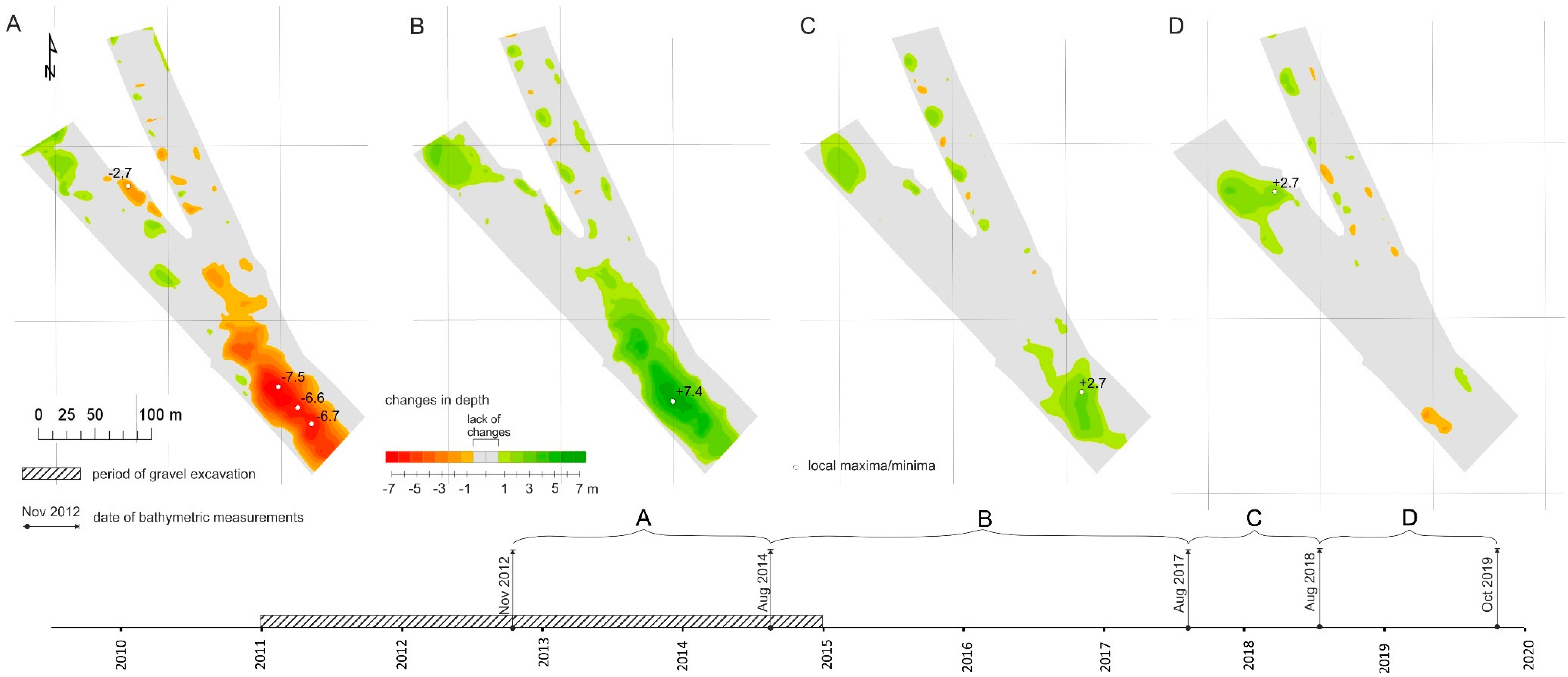
The bathymetric plan documents the shape of the channel in August 2017 and 2018 (Figure 6), and analysis of this and the plan of differences from 2014–2017 and 2017–2018 indicates significant post-extraction changes in the shape of the excavation trough. The most significant change was a reduction in the maximum depth of the excavation from 8.8 m to 3.0 m, a change of 5.8 m.
The research shows that the trough has been backfilled with the load currently transported along the Vistula. Downstream of the excavation (sampling point 5), the fractional composition of the sediments is similar to that found during the first sediment collection in 2014. Analysis of the plan of differences also shows that the boundaries of the excavation are stable and are not subject to erosion. The process of intensive backfilling with transported material is different from that found by Kondolf [9] and Rinaldi et al. [12]. These authors claim that, in the case of abandoned in-stream excavations, the underwater slope retreats due to upstream erosion, and the excavation migrates upstream. According to Osuch [31], the river needs an average of 500 years to replenish the loss of material caused by an in-stream extraction lasting ten years, assuming that no structures inhibit sediment transit in the upper reaches. Yuill [22] reports the Mississippi channel recovery completed after 4.4 to 10 years, and Gob [32] estimated the time of recovery of the Semois river in Belgium for 10 years. For Mediterranean rivers, this time is estimated at 12–14 years after mining ended [33,34,35]. Those cases, however, are rare, because of concurrent excessive extraction and sediment supply scarcity.
The process observed in the Vistula case is undoubtedly influenced by the diverse channel geometry and constant delivery of sediments, mainly by the river Przemsza [36]. The mean annual suspended sediment load of Vistula upstream from the studied section is calculated for ca. 21,000 tons, while Przemsza delivers annually 180,000 tons of suspended sediments, most of which are of anthropogenic origin [36]. A significant amount of sediments supplied by the river Przemsza and the decrease of sediment transport capacity in the artificial extension of the Vistula channel allowed for a rapid, almost complete backfilling of the excavation three years after the end of its operation. In the excavation zone, sediment accumulation occurs, and this has raised its bed and reduced its size from 31,715 m3 in 2014 to 9210 m3 in 2018. Thus, the excavation was backfilled with river sediments with a volume of 22,505 m3. Both above and below the excavation, no significant changes in channel morphometry were found.
The initiation of movement of all material in the bedload mixture occurs when the Shields parameter (Equation (1)) θ ≥ 0.1; below this value, larger material remains on the bed surface [37]. Such conditions are met for a grains mixture with D50 = 0.6 mm, which infills the excavation in the study site when the water level in the Pustynia gauging station is 2.6 m, which is in a range of average water stages. When the water stage reaches 2.6 m, the shear stress τ (Equation (2)) calculated for channel upstream and downstream the extension varies, and drops from 96.8 N/m2 in the 40 m wide channel to 59.6 N/m2 in the channel extension. The Shields parameter decreases from 0.1 to 0.06, which means that the channel extension stops the sediment transport. Particle size analysis shows that the excavation was filled with sand with a D50 ~0.6 mm, i.e., with finer material than in the upstream samples. With the hydrological conditions existing in the section (Hav = 2.6m, Qav = 44.4 m3/s), particles of this size are in continuous transport, as already at average flow. At the same average flow, particles of ≥ 60 mm diameter for which θ < 0.1 remain at the bottom. It is almost impossible to establish a single value for the Shields parameter at which grains corresponding to D50 of the sediment found in the trough are initiated into motion. Therefore, there is a range of θ values, and hence a specific range of hydrological conditions in which material could be transported as the bedload. The advantage of calculating the initiation of sediment movement using the Shields parameter is that it is not affected by particle density or water properties, e.g., due to different temperatures.
It must be remembered that the rate of post-extraction backfilling cannot be precisely calculated. This is because several variables would have to be taken into account, including the diversity of fractions, grain sphericality, the phenomenon of grains jamming up, the heterogeneity of hydro-morphological conditions along the section, hydrodynamics, and flow turbulence over the excavation itself, which will additionally change as the excavation becomes shallower. Haghnazar et al. [26] suggest, for example, that for complete pit infilling, its depth should be less than 70% of the flow depth, however, as the results of our study show, this condition is not necessary when the river is constantly fed with sand.
4. Conclusions
Analysis of the changes to the Vistula channel means that, after cessation of exploitation, the in-stream extraction trough was backfilled quickly with sand transported by the river. The most crucial and favorable factors are the sediment supply from the Przemsza catchment and the expansion of the channel, and thus a decrease in sediment transport capacity. In conditions of sediment transport capacity reduction, grains are deposited on the upstream slope of the abandoned pit, similarly to the mechanism of delta propagation.
Upstream erosion and incision processes were not found in the analyzed section, and the presence of the post-extraction pit did not change the morphometry of the channel either upstream or downstream. No post-mining coarsening of the bed material was found. On the contrary, an admixture of finer fractions was found in the composition of sediments downstream, a consequence of the discharge of fine-grained sand from the excavation during exploitation works.
Spontaneous backfilling of the excavation seems to be a rare phenomenon as, in the subject literature, in-stream sediment extraction usually causes local channel incision. The results of our research can be used as a suggestion for the location of sustainable in-channel excavations to minimize the degradation of the river bed.
Author Contributions
Conceptualization, T.M., A.C., and S.C.; methodology, T.M. and A.C.; software, B.S.; validation, T.M., A.C., and S.C.; formal analysis, A.C.; investigation, T.M.; resources, T.M. and A.C., data curation, T.M., A.C., and B.S.; writing—original draft preparation, T.M., and A.C.; writing—review and editing, A.C.; visualization, B.S.; supervision, S.C. All authors have read and agreed to the published version of the manuscript.
Funding
This research received no external funding.
Data Availability Statement
The data presented in this study are available on request from the corresponding author.
Conflicts of Interest
The authors declare no conflict of interest.
References
- Kondolf, G.M. Geomorphic and environmental effects of in-stream gravel mining. Landsc. Urban Plan. 1994, 28, 225–243. [Google Scholar] [CrossRef]
- Brown, A.V.; Lyttle, M.M.; Brown, K.B. Impacts of gravel mining on gravel bed streams. Trans. Am. Fish. Soc. 1998, 127, 979–994. [Google Scholar] [CrossRef]
- Surian, N.; Rinaldi, M. Morphological response to river engineering and management in alluvial channels in Italy. Geomorphology 2003, 50, 307–326. [Google Scholar] [CrossRef]
- Koehnken, L.; Rintoul, M.S.; Goichot, M.; Tickner, D.; Loftus, A.C.; Acreman, M.C. Impacts of riverine sand mining on freshwater ecosystems: A review of the scientific evidence and guidance for future research. River Res. Appl. 2020, 36, 362–370. [Google Scholar] [CrossRef]
- Korpak, J. The influence of river training on mountain channel changes (Polish Carpathian Mountains). Geomorphology 2007, 92, 166–181. [Google Scholar] [CrossRef]
- Korpak, J.; Krzemień, K.; Radecki-Pawlik, A. Wpływ budowli regulacyjnych i poboru rumowiska na koryta rzek i potoków górskich–wybrane przykłady z rzek karpackich. Gospod. Wodna 2009, 7, 274–281. [Google Scholar]
- Gorczyca, E.; Krzemień, K.; Liro, M.; Sobucki, M. Changes in mountain river channels and their environmental effects. In Open Channel Hydraulics, River Hydraulics Structures and Fluvial Geomorphology: For Engineers, Geomorphologists and Physical Geographers; Radecki-Pawlik, A., Hradecky, J., Pagliara, S., Hendrickson, E., Eds.; CRC Press: Boca Raton, FL, USA, 2017; pp. 303–321. [Google Scholar]
- Galay, V.J. Causes of river bed degradation. Water Resour. Res. 1983, 19, 1057–1090. [Google Scholar] [CrossRef]
- Kondolf, G.M. Hungry water: Effects of dams and gravel mining on river channels. Environ. Manag. 1997, 21, 533–551. [Google Scholar] [CrossRef]
- Wyżga, B. Wpływ eksploatacji osadów z koryta na system rzeczny. In Współczesna ewolucja Rzeźby Polski; Kotarba, A., Krzemień, K., Święchowicz, J., Eds.; IGiGP UJ: Kraków, Poland, 2005; pp. 531–536. [Google Scholar]
- Yanmaz, A.M.; Cicekdag, O. Channel mining induced stream bed instability around bridges. Proceedings of Watershed Management 2000 and Operations Management 2000, Fort Collins, CO, USA, 20–24 June; pp. 1–8.
- Rinaldi, R.; Wyżga, B.; Surian, N. Sediment mining in alluvial channels: Physical effects and management perspectives. River Res. Appl. 2005, 21, 805–828. [Google Scholar] [CrossRef] [Green Version]
- Chełmicki, W.; Krzemień, K.; Werritty, A. Struktura rumowiska korytowego Feshie River (Szkocja). Folia Geogr. Ser. Geogr. -Phys. 1993, 24–25, 17–30. [Google Scholar]
- Wyżga, B. Present-day downcutting of the Raba River channel (Western Carpathians, Poland) and its environmental effects. Catena 1991, 18, 551–566. [Google Scholar] [CrossRef]
- Barman, B.; Sarma, A.K.; Kumar, B. Mining pit migration of an alluvial channel: Experimental and numerical investigations. ISH J. Hydraul. Eng. 2020, 26, 448–456. [Google Scholar] [CrossRef]
- Krzemień, K. The Czarny Dunajec River, Poland, as an example of human-induced development tendencies in a mountain river channel. Landf. Anal. 2003, 4, 57–64. [Google Scholar]
- Marston, R.A.; Bravard, J.-P.; Green, T. Impacts of reforestation and gravel extraction on the Malnant River, Haute-Savoie, French Alps. Geomorphology 2003, 55, 65–74. [Google Scholar] [CrossRef]
- Augustowski, B. Spostrzeżenia nad zmianami antropogenicznymi w korycie rzeki Ropy w Karpatach w okolicy Biecza. Zeszyty Geograficzne WSP w Gdańsku 1968, 10, 161–168. [Google Scholar]
- Wyżga, B. Impact of the channelization-induced incision of the Skawa and Wisłoka Rivers, southern Poland, on the conditions of overbank deposition. Regul. Rivers Res. Manag. 2001, 17, 85–100. [Google Scholar] [CrossRef]
- Collins, B.D.; Dunne, T. Gravel transport, gravel harvesting, and channel-bed degradation in rivers draining the southern Olympic Mountains, Washington, USA. Environ. Geol. Water Sci. 1989, 13, 213–224. [Google Scholar] [CrossRef]
- Dépret, T.; Virmoux, C.; Gautier, E.; Piégay, H.; Doncheva, M. Lowland gravel-bed river recovery through former mining reaches, the key role of sand. Geomorphology 2021, 373, 107493. [Google Scholar] [CrossRef]
- Yuill, B.T.; Gaweesh, A.; Allison, M.A.; Meselhe, E.A. Morphodynamic evolution of a lower Mississippi River channel bar after sand mining. Earth Surf. Process. Landf. 2016, 41, 526–542. [Google Scholar] [CrossRef]
- Lee, H.Y.; Fu, D.T.; Song, M.H. Migration of rectangular mining pit composed of uniform sediments. J. Hydraul. Eng. 1993, 119, 64–80. [Google Scholar] [CrossRef]
- Gill, M.A. Hydrodynamics of mining pits in erodible bed under steady flow. J. Hydraul. Eng. 1994, 120, 1337–1348. [Google Scholar] [CrossRef]
- Cao, Z.; Pender, G. Numerical modelling of alluvial rivers subject to interactive sediment mining and feeding. Adv. Water Resour. 2004, 27, 533–546. [Google Scholar] [CrossRef]
- Haghnazar, H.; Sangsefidi, Y.; Mehraein, M.; Tavakol-Davani, H. Evaluation of infilling and replenishment of river sand mining pits. Environ. Earth Sci. 2020, 79, 1–18. [Google Scholar] [CrossRef]
- Barman, B.; Kumar, B.; Sarma, A.K. Dynamic characterization of the migration of a mining pit in an alluvial channel. Int. J. Sediment Res. 2019, 34, 155–165. [Google Scholar] [CrossRef]
- Czajka, A.; Ciszewski, D. Deposition of overbank sediments within a regulated reach of the the upper Odra River, Poland. IAHS-AISH Publ. 2010, 137–142. [Google Scholar]
- Szarlowicz, K.; Reczynski, W.; Czajka, A.; Spyt, B.; Szacilowski, G. Comprehensive study of the mountainous lake sediments in relation to natural and anthropogenic processes and time (Mały Staw Lake, Poland). Environ. Sci. Pollut. Res. 2018, 25, 3335–3347. [Google Scholar] [CrossRef] [Green Version]
- Molenda, T.; Ciupa, T.; Suligowski, R. The properties of reservoir water in post-mining excavations of Cambrian and Devonian quartzite sandstones (Holy Cross Mountains). Environ. Earth Sci. 2020, 79, 1–9. [Google Scholar] [CrossRef]
- Osuch, B. Problemy wynikające z nadmiernej eksploatacji kruszywa rzecznego na przykładzie rzeki Wisłoki. Zeszyty Naukowe Akademii Górniczo-Hutniczej 1968, 219, 283–301. [Google Scholar]
- Gob, F.; Houbrechts, G.; Hiver, J.M.; Petit, F. River dredging, channel dynamics and bedload transport in an incised meandering river (the River Semois, Belgium). River Res. Appl. 2005, 21, 791–804. [Google Scholar] [CrossRef]
- Rovira, A.; Batalla, R.J.; Sala, M. Response of a river sediment budget after historical gravel mining (the lower Tordera, NE Spain). River Res. Appl. 2005, 21, 829–847. [Google Scholar] [CrossRef]
- Sanchis-ibor, C.; Segura-Beltrán, F.; Almonacid-Caballer, J. Channel forms recovery in an ephemeral river after gravel mining (Palancia River, Eastern Spain). Catena 2017, 158, 357–370. [Google Scholar] [CrossRef] [Green Version]
- Calle, M.; Alho, P.; Benito, G. Channel dynamics and geomorphic resilience in an ephemeral Mediterranean river affected by gravel mining. Geomorphology 2017, 285, 333–346. [Google Scholar] [CrossRef]
- Lajczak, A. Transport of suspended sediment by the Vistula River basin upstream of Kraków, southern Poland, and the human impact during the second half of the 20th century. IAHS-AISH Publ. 2012, 49–56. [Google Scholar]
- Jaeggi, M.N.R. Grain sorting seminar–introduction. In Proceedings of the International Grain Sorting Seminar, Ascona; Technischen Hochschule Zurich, 1992. [Google Scholar]
Figure 1.
Location of the study area. (A) study site location in upper part of the Vistula River course in Poland, (B) catchments of the Vistula, the Przemsza and the Soła rivers, (C) local, surficial geologic map. Downstream the study site the Dwory Canal is visible, (D) the Vistula channel in the study site with the gauging station next to the bridge and the unfinished dock, planned as a part of Dwory Canal infrastructure

Figure 2.
Location of bottom sediment sampling points (1–5) in 2014 and 2019 marked on the bathymetric maps and on the longitudinal profiles of the Vistula channel in the study site.
Figure 2.
Location of bottom sediment sampling points (1–5) in 2014 and 2019 marked on the bathymetric maps and on the longitudinal profiles of the Vistula channel in the study site.

Figure 3.
Bathymetry as of 2012–2014. Cross profiles A-A’, B-B’, C-C’ and D-D’ show the changes in channel geometry. Numbers indicate the deepest points detected during the surveys.
Figure 3.
Bathymetry as of 2012–2014. Cross profiles A-A’, B-B’, C-C’ and D-D’ show the changes in channel geometry. Numbers indicate the deepest points detected during the surveys.

Figure 4.
Plan of differences in depth of the studied section of the Vistula. (A–D) the Vistula channel bottom topography changes in periods between the bathymetric surveys marked on the time axis.
Figure 4.
Plan of differences in depth of the studied section of the Vistula. (A–D) the Vistula channel bottom topography changes in periods between the bathymetric surveys marked on the time axis.

Figure 5.
Cumulative percentage grain size distribution of bed surface material in 2014 and 2019.

Figure 6.
Bathymetry as of 2017–2018. Cross profiles A-A’ and B-B’ show the changes in channel geometry. Numbers indicate the deepest points detected in the channel during the surveys.
Figure 6.
Bathymetry as of 2017–2018. Cross profiles A-A’ and B-B’ show the changes in channel geometry. Numbers indicate the deepest points detected in the channel during the surveys.

Publisher’s Note: MDPI stays neutral with regard to jurisdictional claims in published maps and institutional affiliations. |
© 2021 by the authors. Licensee MDPI, Basel, Switzerland. This article is an open access article distributed under the terms and conditions of the Creative Commons Attribution (CC BY) license (http://creativecommons.org/licenses/by/4.0/).
Share and Cite
MDPI and ACS Style
Molenda, T.; Czajka, A.; Czaja, S.; Spyt, B. Rapid River Bed Recovery after the In-Channel Mining: The Case of Vistula River, Poland. Water 2021, 13, 623. https://doi.org/10.3390/w13050623
AMA Style
Molenda T, Czajka A, Czaja S, Spyt B. Rapid River Bed Recovery after the In-Channel Mining: The Case of Vistula River, Poland. Water. 2021; 13(5):623. https://doi.org/10.3390/w13050623
Chicago/Turabian StyleMolenda, Tadeusz, Agnieszka Czajka, Stanisław Czaja, and Barbara Spyt. 2021. "Rapid River Bed Recovery after the In-Channel Mining: The Case of Vistula River, Poland" Water 13, no. 5: 623. https://doi.org/10.3390/w13050623
Note that from the first issue of 2016, this journal uses article numbers instead of page numbers. See further details here.