
Contribution of International Projects to the Development of Maritime Spatial Planning Structural Elements in the Northern Adriatic: The Experience of Slovenia


Abstract
:1. Introduction
Importance of International Projects in the Development of MSP Elements
2. Materials and Methods
2.1. Problem Definition and Research Questions
- Which key international projects in the field of MSP development in the Northern Adriatic were implemented also in Slovenia?
- Which elements of the plan (Slovenia started preparing its first plan in September 2019. During submission of this article the draft of the plan (hereinafter referred to as “the draft plan”) was in the phase of public consultation) were formed in individual projects?
- What is the contribution of such projects to the first generation of the plan?
2.2. Methodology
- Content comparison of the analytical part of individual projects and the draft plan was performed and the rate of coincidence defined to assess compliance with international and national starting points, objectives, and guidelines.
- Regarding the expert bases of individual projects, the extent (%) of their use in the preparation of the draft plan was determined.
- Concerning the stakeholders and public participation, their pool and detailed structural classification was defined and the coincidence (%) with the draft plan determined for each project.
- In assessing the identification and balancing of interests, a set of eleven fields, as defined in the MSP Directive, was used with the addition (in accordance with the draft plan) of urban development, covering other interests of local communities regarding the land–sea interactions. The presence and content of interests was determined and categorized into three levels. Moreover, the use of specific protocols and/or tools for the balancing of interests was identified.
- Regarding the administrative competences, the focus was on spatial solutions of individual projects to find out how the sea and land areas were determined as to administrative competences and spatial planning authorities.
- The international aspect of individual projects was addressed by recording the number of implemented events with international participation and categorized into three value groups. In addition, the participating countries and their institutions involved in the implementation of projects were identified.
- The development of databases and the use of analytical tools were determined by analyzing the types of data used, the method of obtaining them, their accuracy and purpose, and processing in accordance with the project terms of reference. The extent of development of databases and analytical tools in individual projects was categorized into three value groups.
3. Results
3.1. Review of the Projects and Their Content Characteristics
3.2. Analysis and Comparison Elements
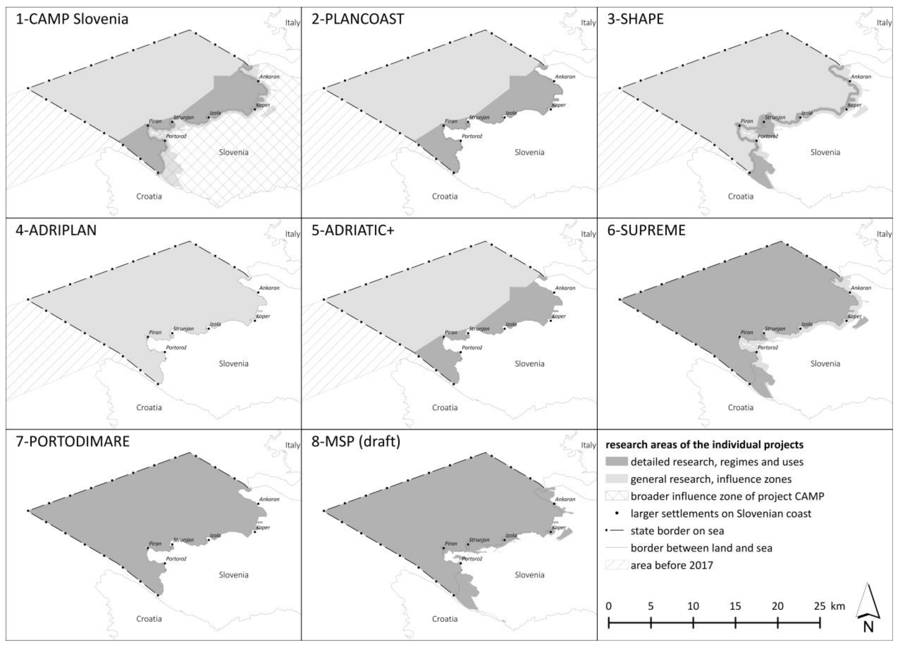
3.3. Analysis of Project Application Areas
- The internal waters were discussed in detail in each project (with the exception of the ADRIPLAN project).
- The territorial sea was discussed in detail in two projects and was the subject of general consideration in five.
- The coastal strip of 100 m from the shore was treated in projects four times and the strip of 200 m three times. The coastal strip in additional widths of 300 m and 400 m was considered in general three times.
3.4. Analysis of Methodological and Structural Elements, and the Assessment of Consistency with the Draft Plan
3.4.1. Starting Points, Objectives, and Guidelines
3.4.2. Expert Bases
3.4.3. Stakeholders and Public Participation
3.4.4. Identification and Balancing of Interests
- (a)
- Explicit treatment comprising a detailed definition of sectoral characteristics and interests (Figure 2a,b).
- (b)
- Indirect treatment consisting of partial identification and/or indirect consideration of sectoral interests.
- (c)
- Sectors and their interests are not explicitly or indirectly defined.
3.4.5. Administrative Responsibilities for the Sea and Land
- (a)
- Definition of water area as a specific spatial planning unit (e.g., parcels of territorial sea or internal waters).
- (b)
- Definition of the coastal zone as a specific spatial planning unit, covering the area from the shoreline inwards.
- (c)
- Identification of spatial planning authorities and their administrative competences.
3.4.6. International Aspect
3.4.7. Development of Databases and Analytical Tools
3.5. Synthesis of Findings
- Identification of the starting points of international conventions, protocols, directives, and recommendations and national platforms for spatial development and protection, and the objectives set out in the overarching strategic national documents, etc.
- Creation of thematic expert bases and conceptual projects, their application and identification of the needs for additional expert bases for the preparation of the draft plan.
- Identification and involvement of stakeholders and decision-makers, active participation, and public presentations.
- Identification of interests and conflicts and demonstration of their mitigation (focal point in the CAMP Slovenia, SHAPE, ADRIPLAN, SUREME, and PORTODIMARE projects).
- Addressing the administrative challenges in the field of competence in the planning and management of water and land areas (except for the PORTODIMARE project).
- Taking account of the international and cross-border aspects in the development of maritime spatial planning and the draft plan in particular.
- Continuous upgrading of information infrastructure and contribution to the development of databases (focal points in the SHAPE, SUPREME, ADRIPLAN, and PORTODIMARE projects).
- Fully applicable elements, i.e., fully developed and directly transferable elements (e.g., consensus on ICZM coastal zone, coordinated with local communities; prioritizing of sectoral fields as set out in the MSP Directive; formulated protected areas and protection regimes, the Geoportal, and tools; and international starting points).
- Largely applicable elements, i.e., developed methodology and the content structure for the draft plan preparation, harmonized cross-sectoral interests, identified stakeholders, defined administrative aspects, and cross-border coordination of the impacts of certain activities at sea.
- Conditionally applicable or indirectly transferred elements, i.e., identified and already consensual local interests, specific data, sectoral expert bases, and spatial solutions.
4. Discussion
5. Conclusions
Author Contributions
Funding
Institutional Review Board Statement
Informed Consent Statement
Data Availability Statement
Conflicts of Interest
References
- The European Parliament and the Council of the European Union Directive 2014/89/EU of the European Parliament and of the Council of 23 July 2014 Establishing a Framework for Maritime Spatial Planning. Available online: https://eur-lex.europa.eu/legal-content/EN/TXT/?uri=CELEX:32014L0089 (accessed on 4 February 2021).
- Protocol on Integrated Coastal Zone Management in the Mediterranean. Official Journal of the European Union 34/19. Available online: https://eur-lex.europa.eu/legal-content/EN/TXT/PDF/?uri=CELEX:22009A0204(01)&from=EN (accessed on 4 February 2021).
- Romano, B.; Zullo, F. The Urban Transformation of Italy’s Adriatic Coastal Strip: Fifty Years of Unsustainability. Land Use Policy 2014, 38, 26–36. [Google Scholar] [CrossRef]
- Čok, G. Pravni okvir in strokovne prakse pri planiranju in načrtovanju posegov v obalnem pasu. In Prostorski Načrtovalci 21. Stoletja; Zavodnik, L., Ed.; Fakulteta za Gradbeništvo in Geodezijo Univerze v Ljubljani: Ljubljana, Slovenia, 2018; pp. 135–141. ISBN 978-961-6884-56-3. [Google Scholar]
- Balažič, G. Relikti Socializma v Prostoru—Primer Mestne Občine Koper. Ph.D. Thesis, Univerza na Primorskem, Koper, Slovenia, 2006. [Google Scholar]
- Ažman Momirski, L. Urbani obalni prostori Kopra. Ann. Ser. Hist. Sociol. 2015, 25, 19–32. [Google Scholar]
- Suau, C. Urban History, Morphology and Environmental Urban Design of Maritime Spaces in the Old Town of Koper. Ann. Ser. Hist. Sociol. 2015, 25, 76–96. [Google Scholar]
- UNEP/MAP. The Mediterranean Action Plan. Barcelona Convention and Its Protocols. Overview; UNEP/MAP: Athens, Greece, 2015. [Google Scholar]
- Brundtland, G.H. Report of the World Commission on Environment and Development: Our Common Future. United Nations General Assembly Document A/42/427; United Nations: New York, NY, USA, 1987. [Google Scholar]
- CEC (Commission of the European Communities). European Spatial Development Perspective: Towards Balanced and Sustainable Development of the Territory of the EU; CEC: Luxemburg, 1999. [Google Scholar]
- Čok, G. Designing Baselines for Developing an Integrated Coastal Zone Management System in the Adriatic: Experience in Slovenia. Archit. City Environ. 2017, 11, 15–32. [Google Scholar] [CrossRef] [Green Version]
- Ehler, C.; Zaucha, J.; Gee, K. Maritime/marine spatial planning at the interface of research and practice. In Maritime Spatial Planning: Past, Present, Future; Springer International Publishing: Berlin/Heidelberg, Germany, 2019; pp. 1–21. ISBN 9783319986968. [Google Scholar]
- Bieda, A.; Adamczyk, T.; Parzych, P. Maritime Spatial Planning in the European Union on the Example of the Polish Part of the Baltic Sea. Water 2019, 11, 555. [Google Scholar] [CrossRef] [Green Version]
- Cavallo, M.; Elliott, M.; Touza, J.; Quintino, V. The Ability of Regional Coordination and Policy Integration to Produce Coherent Marine Management: Implementing the Marine Strategy Framework Directive in the North-East Atlantic. Mar. Policy 2016, 68, 108–116. [Google Scholar] [CrossRef] [Green Version]
- Kyvelou, S.S.; Ierapetritis, D. Discussing and Analyzing “Maritime Cohesion” in MSP, to Achieve Sustainability in the Marine Realm. Sustainability 2019, 11, 3444. [Google Scholar] [CrossRef] [Green Version]
- Friess, B.; Grémaud-Colombier, M. Policy Outlook: Recent Evolutions of Maritime Spatial Planning in the European Union. Mar. Policy 2019, 103428. [Google Scholar] [CrossRef]
- De Grunt, L.S.; Ng, K.; Calado, H. Towards Sustainable Implementation of Maritime Spatial Planning in Europe: A Peek into the Potential of the Regional Sea Conventions Playing a Stronger Role. Mar. Policy 2018, 95, 102–110. [Google Scholar] [CrossRef]
- Conference for the Adoption of the Convention on Biological Diversity. Convention on Biological Diversity. UNEP. 20–21 May 1992, Nairobi, Kenya. Available online: https://www.cbd.int/meetings/BDCONF (accessed on 5 February 2021).
- The European Parliament and the Council of the European Union COM(2008)791—Roadmap for Maritime Spatial Planning: Achieving Common Principles in the EU. Available online: https://eur-lex.europa.eu/legal-content/EN/TXT/?uri=celex%3A52008DC0791 (accessed on 4 February 2021).
- Farella, G.; Tassetti, A.N.; Menegon, S.; Bocci, M.; Ferrà, C.; Grati, F.; Fadini, A.; Giovanardi, O.; Fabi, G.; Raicevich, S.; et al. Ecosystem-Based MSP for Enhanced Fisheries Sustainability: An Example from the Northern Adriatic (Chioggia—Venice and Rovigo, Italy). Sustainability 2021, 13, 1211. [Google Scholar] [CrossRef]
- Peel, D.; Lloyd, M.G. The Social Reconstruction of the Marine Environment: Towards Marine Spatial Planning? Town Plan. Rev. 2004, 75, 359–378. [Google Scholar] [CrossRef]
- Taussik, J. The Influence of Institutional Systems on Planning the Coastal Zone: Experience from England/Wales and Sweden. Plan. Pract. Res. 1997, 12, 9–20. [Google Scholar] [CrossRef]
- Olsen, S.B. Frameworks and Indicators for Assessing Progress in Integrated Coastal Management Initiatives. Ocean Coast. Manag. 2003, 46, 347–361. [Google Scholar] [CrossRef]
- Taveira Pinto, F. The Practice of Coastal Zone Management in Portugal. J. Coast. Conserv. 2004, 10, 147–157. [Google Scholar] [CrossRef]
- Kay, R.; Alder, J. Coastal Planning and Management; CRC Press: Boca Raton, FL, USA, 2017. [Google Scholar]
- González-Riancho, P.; Sanò, M.; Medina, R.; García-Aguilar, O.; Areizaga, J. A Contribution to the Implementation of ICZM in the Mediterranean Developing Countries. Ocean Coast. Manag. 2009, 52, 545–558. [Google Scholar] [CrossRef]
- Maes, F. The International Legal Framework for Marine Spatial Planning. Mar. Policy 2008, 32, 797–810. [Google Scholar] [CrossRef]
- Jay, S.; Alves, F.L.; O’Mahony, C.; Gomez, M.; Rooney, A.; Almodovar, M.; Gee, K.; de Vivero, J.L.S.; Gonçalves, J.M.S.; da Fernandes, M.L.; et al. Transboundary Dimensions of Marine Spatial Planning: Fostering Inter-Jurisdictional Relations and Governance. Mar. Policy 2016, 65, 85–96. [Google Scholar] [CrossRef]
- Almodovar, M.; de Armas, D.; Lopes Alves, F.; Bentes, L.; Fonseca, C.; Galofré, J.; Gee, K.; Gómez-Ballesteros, M.; Gonçalves, J.; Henriques, G.; et al. TPEA Good Practice Guide: Lessons for Cross-Border MSP from Transboundary Planning in the European Atlantic (Book, 2014) [WorldCat.Org]; Jay, S., Gee, K., Eds.; University of Liverpool: Liverpool, UK, 2014. [Google Scholar]
- Agardy, T.; Davis, J.; Sherwood, K.; Vestergaard, O. Taking Steps towards Marine and Coastal Ecosystem-Based Management: An Introductory Guide; UNEP: Nairobi, Kenya, 2011; Volume 189, ISBN 978-92-807-3173-6. [Google Scholar]
- Ehler, C.; Douvere, F. Marine Spatial Planning: A Step-by-Step Approach Toward Ecosystem-Based Management. Available online: https://repository.oceanbestpractices.org/handle/11329/459 (accessed on 4 February 2021).
- Douvere, F. The Importance of Marine Spatial Planning in Advancing Ecosystem-Based Sea Use Management. Mar. Policy 2008, 32, 762–771. [Google Scholar] [CrossRef]
- Giebels, D.; van Buuren, A.; Edelenbos, J. Ecosystem-Based Management in the Wadden Sea: Principles for the Governance of Knowledge. J. Sea Res. 2013, 82, 176–187. [Google Scholar] [CrossRef]
- Costanza, R.; D’Arge, R.; De Groot, R.; Farber, S.; Grasso, M.; Hannon, B.; Limburg, K.; Naeem, S.; O’Neill, R.V.; Paruelo, J.; et al. The Value of the World’s Ecosystem Services and Natural Capital. Nature 1997, 387, 253–260. [Google Scholar] [CrossRef]
- Long, R. Legal Aspects of Ecosystem-Based Marine Management in Europe. Ocean Yearb. Online 2014, 26, 417–484. [Google Scholar] [CrossRef]
- Roxburgh, T.; Dodds, L. Towards Sustainability in the Celtic Sea—A Guide to Implementing the Ecosystem Approach through the Marine Strategy Framework Directive; WWF–UK: Surrey, UK, 2012. [Google Scholar]
- Tyldesley, D.; Hunt, B. Review of How the Land Use Planning System Could Influence the Development of a Marine Spatial Planning System for England; English Nature: Peterborough, UK, 2003. [Google Scholar]
- Allmendinger, P.; Barker, A.; Stead, S. Delivering Integrated Coastal-Zone Management through Land-Use Planning. Plan. Pract. Res. 2002, 17, 175–196. [Google Scholar] [CrossRef]
- Shipman, B.; Roberts, H.; Dworak, T.; Zamparutti, T.; Krüger, I.; Veidemane, K.; Mashkina, O.; Parrod, C.; Ceresil, E.; Moarcas, A.; et al. Land Sea Interactions in Maritime Spatial Planning; European Union (DG Environment): Brussels, Belgium, 2008. [Google Scholar]
- Kidd, S.; Shaw, D.; Janssen, H. Exploring Land-Sea Interactions: Insights for Shaping Territorial Space. Europa XXI 2019, 36, 45–59. [Google Scholar] [CrossRef] [Green Version]
- Ramieri, E.; Bocci, M.; Markovic, M. Linking integrated coastal zone management to maritime spatial planning: The mediterranean experience. In Maritime Spatial Planning: Past, Present, Future; Springer International Publishing: Berlin/Heidelberg, Germany, 2019; pp. 271–294. ISBN 9783319986968. [Google Scholar]
- NOAA. Coastal Services Center Introduction to Stakeholder Participation—Coastal and Marine Planning—Training; NOAA: Washington, DC, USA, 2007; p. 20. [Google Scholar]
- Keijser, X.; Ripken, M.; Mayer, I.; Warmelink, H.; Abspoel, L.; Fairgrieve, R.; Paris, C. Stakeholder Engagement in Maritime Spatial Planning: The Efficacy of a Serious Game Approach. Water 2018, 10, 724. [Google Scholar] [CrossRef] [Green Version]
- Areizaga, J.; Sanò, M.; Medina, R.; Juanes, J. A Methodological Approach to Evaluate Progress and Public Participation in ICZM: The Case of the Cantabria Region, Spain. Ocean Coast. Manag. 2012, 59, 63–76. [Google Scholar] [CrossRef]
- Koutrakis, E.T.; Sapounidis, A.; Marzetti, S.; Giuliani, V.; Martino, S.; Fabiano, M.; Marin, V.; Paoli, C.; Roccatagliata, E.; Salmona, P.; et al. Public Stakeholders’ Perception of ICZM and Coastal Erosion in the Mediterranean. Coast. Manag. 2010, 38, 354–377. [Google Scholar] [CrossRef]
- Ernoul, L. Combining Process and Output Indicators to Evaluate Participation and Sustainability in Integrated Coastal Zone Management Projects. Ocean Coast. Manag. 2010, 53, 711–716. [Google Scholar] [CrossRef]
- Salas-Leiton, E.; Vieira, L.R.; Guilhermino, L. Sustainable Fishing and Aquaculture Activities in the Atlantic Coast of the Portuguese North Region: Multi-Stakeholder Views as a Tool for Maritime Spatial Planning. Sustainability 2021, 13, 663. [Google Scholar] [CrossRef]
- McGowan, L.; Jay, S.; Kidd, S. Scenario-building for marine spatial planning. In Maritime Spatial Planning: Past, Present, Future; Springer International Publishing: Berlin/Heidelberg, Germany, 2019; pp. 327–351. ISBN 9783319986968. [Google Scholar]
- Buanes, A.; Jentoft, S.; Runar Karlsen, G.; Maurstad, A.; Søreng, S. In Whose Interest? An Exploratory Analysis of Stakeholders in Norwegian Coastal Zone Planning. Ocean Coast. Manag. 2004, 47, 207–223. [Google Scholar] [CrossRef]
- Pomeroy, R.; Douvere, F. The Engagement of Stakeholders in the Marine Spatial Planning Process. Mar. Policy 2008, 32, 816–822. [Google Scholar] [CrossRef]
- Pentz, T.-A. Stakeholder Involvement in MSP; WWF Baltic Sea Office: Hamburg, Germany, 2012. [Google Scholar]
- Twomey, S.; O’Mahony, C. Stakeholder processes in marine spatial planning: Ambitions and realities from the european atlantic experience. In Maritime Spatial Planning: Past, Present, Future; Springer International Publishing: Berlin/Heidelberg, Germany, 2019; pp. 295–325. ISBN 9783319986968. [Google Scholar]
- Bocci, M.; Sangiuliano, S.J.; Sarretta, A.; Ansong, J.O.; Buchanan, B.; Kafas, A.; Caña-Varona, M.; Onyango, V.; Papaioannou, E.; Ramieri, E.; et al. Multi-Use of the Sea: A Wide Array of Opportunities from Site-Specific Cases across Europe. PLoS ONE 2019, 14, e0215010. [Google Scholar] [CrossRef] [PubMed] [Green Version]
- Ansong, J.; Calado, H.; Gilliland, P.M. A Multifaceted Approach to Building Capacity for Marine/Maritime Spatial Planning Based on European Experience. Mar. Policy 2019, 103422. [Google Scholar] [CrossRef]
- The European Parliament and the Council of the European Union Directive 2008/56/EC of the European Parliament and of the Council of 17 June 2008 Establishing a Framework for Community Action in the Field of Marine Environmental Policy (Marine Strategy Framework Directive). Available online: https://eur-lex.europa.eu/legal-content/EN/TXT/?uri=CELEX%3A32008L0056 (accessed on 4 February 2021).
- Gilliland, P.M.; Laffoley, D. Key Elements and Steps in the Process of Developing Ecosystem-Based Marine Spatial Planning. Mar. Policy 2008, 32, 787–796. [Google Scholar] [CrossRef]
- Valentini, E.; Filipponi, F.; Nguyen Xuan, A.; Passarelli, F.; Taramelli, A. Earth Observation for Maritime Spatial Planning: Measuring, Observing and Modeling Marine Environment to Assess Potential Aquaculture Sites. Sustainability 2016, 8, 519. [Google Scholar] [CrossRef] [Green Version]
- Gabrijelčič, P.; Steinman, F.; Gazvoda, D.; Plazar Mlakar, M.; Mlakar, A.; Hudnik, Š.; Čok, G.; Gosar, L.; Penko, N.; Froggatt, N.; et al. CAMP: Podrobnejša Zasnova Prostorskih Ureditev Obalnega Pasu: Končno Poročilo; Univerza v Ljubljani, Fakulteta za arhitekturo: Ljubljana, Slovenia, 2005. [Google Scholar]
- Požeš, M. PLANCOAST: Integralno Pomorsko Prostorsko Načrtovanje v Okviru Integralnega Upravljanja z Obalnim Območjem; Regional Development Centre Koper: Koper, Slovenia, 2008. [Google Scholar]
- Čok, G.; Mlakar, A.; Segulin, M.; Skubic, A. SHAPE: Shaping an Holistic Approach to Protect the Adriatic Environment between Coast and Sea: Idejna Zasnova Krajinsko Urbanistične Ureditve Za Strunjan in Idejne Rešitve Posameznih Prostorskih Ureditev, Skupina 1; Regional Development Centre Koper: Koper, Slovenia, 2014. [Google Scholar]
- ADRIPLAN WP 1: Set up of MSP. AIP-1.2-1.1—Initial Assessment; Instituto Nazionale di Oceanografia e di Geofisica Sperimentale: Sgonico, Italy, 2014.
- Mezek, S. ADRIATIC PLUS: Project—Sharing Marine and Coastal Cross Management Experiences in the Adriatic Basin: Shape Project; Regional Development Centre Koper: Koper, Slovenia, 2016. [Google Scholar]
- Čok, G.; Plazar, M. SUPREME: Pilotni Projekt Za Pripravo Osnutka Pomorskega Prostorskega Načrta (PPN) Za Območje Slovenije (Zaključno Poročilo); Regional Development Centre Koper: Koper, Slovenia, 2018. [Google Scholar]
- Mezek, S.; Bocci, M.; Krapež, B. PORTODIMARE: Action Plan on the Testing Area (T2.8.3), Ver. 1; Regional Development Centre Koper: Koper, Slovenia, 2020. [Google Scholar]
- Vlada Republike Slovenije. Uradni List RS, Št. 61/17: Zakon o Urejanju Prostora (ZUreP-2). Available online: https://www.uradni-list.si/glasilo-uradni-list-rs/vsebina/2017-01-2915 (accessed on 4 February 2021).
- Vlada Republike Slovenije. Uradni List RS, 76/04: Odlok o strategiji prostorskega razvoja Slovenije (OdSPRS). Available online: https://www.uradni-list.si/glasilo-uradni-list-rs/vsebina/2004-01-3397?sop=2004-01-3397 (accessed on 1 February 2021).
- Vlada Republike Slovenije. Uradni List RS, Št. 41/17: Načrt Upravljanja z Morskim Okoljem Za Obdobje Od 2017 Do 2021. Available online: http://www.pisrs.si/Pis.web/pregledPredpisa?id=URED6974# (accessed on 4 February 2021).
- Čok, G.; Mlakar, A.; Plazar, M.; Repe, B. Osnutek Pomorskega Prostorskega Plana Slovenije. Available online: https://www.gov.si/zbirke/javne-objave/osnutek-pomorskega-prostorskega-plana-slovenije/ (accessed on 4 February 2021).
- Dalla Valle, S.; Dalla Valle, B.; Thaler, J.; Dalla Valle, N.; Šantelj, B. SHAPE: Uskladitev Režimov v 100-m Priobalnem Pasu Jadranskega Morja z Zahtevami 8. Člena Protokola ICZM; Regional Development Centre Koper: Koper, Slovenia, 2014. [Google Scholar]
- EUSAIR. EUSAIR Governing Board, EU Strategy for the Adriatic-Ionian Region. Available online: https://www.adriatic-ionian.eu/about-eusair/governance/ (accessed on 4 February 2021).


| Project Title (Implementation Period) Cooperation Program Participating Countries | Thematic Focus | Focus Activities and Results |
|---|---|---|
| 1. CAMP Slovenia (2004–2007) Coastal Area Management Program Mediterranean Action Plan (UNEP/MAP) In this case, not the individual countries participated, but the UNEP-MAP specialized Regional Activity Centres | Conception of an integrated approach to the management and sustainable development of the coastal zone. | Definition of the coastal zone as a specific spatial planning unit. Participative planning tool: system analysis and analysis of sustainable development perspectives. Production of vulnerability maps of the Slovenian Coast. Conceptual design of spatial arrangements of the coastal zone (expert basis). Comparison of management models for protected nature areas. Regional program for the protection of the environment and water resources. |
| 2. Plancoast (2006–2008) INTERREG IIIB CADSES Germany, Poland, Slovenia, Italy, Albania, Bosnia and Herzegovina, Bulgaria, Croatia, Romania, Serbia (including Montenegro) and Ukraine | Development of tools for integrated coastal and marine planning in the Baltic, Adriatic, and Black Sea regions. | Manual on integrated maritime spatial planning. Maritime spatial planning in selected areas (pilot project). Spatial plans for the coastal zone in accordance with the ICZM principles (pilot project). |
| 3. Shape (2013–2014) Shaping an Holistic Approach to Protect the Adriatic Environment between coast and sea AdriaticIPA 2007–2013 Italy, Slovenia, Croatia, Albania, Bosnia and Herzegovina, Montenegro | Strengthening the system of integrated coastal zone management. | Proposal for the definition of the coastal zone where construction is not possible in accordance with the ICZM Protocol (expert basis). Testing of the integration of maritime and land spatial planning in the Strunjan area, including a proposal for harmonized land use (pilot project). Geographic Information System (GIS) for the coastal zone. |
| 4. Adriplan (2014–2015) Adriatic Ionian maritime spatial Planning DG MARE, EASME Italy, Croatia, Slovenia, Greece | Support for the establishment of MSP in the Adriatic–Ionian Region, focusing on the cross-border aspects. | Formulation of proposals and recommendations for cross-border maritime spatial planning in the Adriatic–Ionian Region. The project is based on integrated assessment of the situation (environmental, legal and administrative bases, economy and society), considering the needs and potentials of the sectors. |
| 5. Adriatic+ (2016) AdriaticIPA 2007–2013 Italy, Croatia, Montenegro, Slovenia | Exchange of experience in the management of marine and coastal areas in the Adriatic region. | Exchange of experiences in the management of marine and coastal areas in the Adriatic region (thematic workshops). Capitalization of the results of three standard projects (NETCET (https://www.netcet.eu, accessed on 1 March 2021) SHAPE (https://www.msp-platform.eu/projects/shaping-holistic-approach-protect-adriatic-environment-between-coast-and-sea, accessed on 1 March 2021) and HAZARD (https://www.msp-platform.eu/projects/hazadr-strengthening-common-reaction-capacity-fight-sea-pollution-oil-toxic-and, accessed on 2 March 2021) and two strategic projects (BALMAS (www.balmas.eu, accessed on 2 March 2021), DEFISHGEAR (http://adriplan.eu/, accessed on 2 March 2021). Feasibility study to set up a decision support system for biodiversity protection measures. |
| 6. Supreme (2018–2019) Supporting maritime spatial Planning in the eastern Mediterranean DG MARE, EASME Italy, Croatia, Greece, Slovenia | Simulation of the procedure and content of MSP—preparation of materials and the first plan. | Cross-section of the situation in the field of available data and interests. Preparation of materials for the plan. Simulation of the MSP process and content (pilot project). Compilation of sectoral and international starting points and objectives. Pool of stakeholders, balancing of interests, thematic workshops. |
| 7. Portodimare (2018–2020) Geoportal of Tools and Data for Sustainable Management of Coastal and Marine Environment Interreg ADRION Italy, Croatia, Greece, Slovenia, Montenegro, Bosnia and Herzegovina | Development and testing of tools and methods to support the implementation of MSP, establishment of a common geoinformation infrastructure. | Upgrading of the SHAPE (http://www.shape-ipaproject.eu/, accessed on 2 March 2021) and ADRIPLAN (http://adriplan.eu/, accessed on 2 March 2021) projects results. Creation of a common information platform (Geoportal). Development of analytical tools for the plan. Testing of selected analytical tools. |
| Maritime Spatial Planning Development | ||
|---|---|---|
| A Maritime Spatial Planning Establishment of the Process | B Maritime Spatial Plan Spatial Act | |
| ↓ Process of the Maritime Spatial Plan Preparation | ↓ Content of the Maritime Spatial Plan | |
| Process Elements | Methodological Elements | Content Elements |
| Promotion of international commitments (conventions, protocols). Rationale for the need to develop maritime spatial planning and integrated management of the coastal zone. Implementation of sustainable planning principles. Promoting the need for participatory planning. Implementation in national legislation. | Definition of starting points. Identification of stakeholders and methods of participation. Development of a database and Geoportal. Expert bases. Setting of strategic and planning objectives. Balancing of interests (range and methodology). International aspects (coordination). Administrative competences. Monitoring and evaluation. | Formal framework (mandatory content). Rationale of MSP (starting points and objectives). Sectors (in line with the MSP Directive). Regimes and uses of maritime space (identification). Spatial and time coordination of the regimes and uses of maritime space. Methods of implementation (provisions, guidelines, protocols). Mapping (database). |
| Project | Sea (Outwards from the Shoreline) | Coast (Inwards from the Shoreline) | Σ Sea | Σ Coast | Σ | ||
|---|---|---|---|---|---|---|---|
| Detailed Research of Regimes and Uses | General Research of influence Areas | Detailed Research of Regimes and Uses | General Research of Influence Areas * | ||||
| (Area in ha) | Percentage Compared to MSP | ||||||
| CAMP Slovenia | Internal waters (4973.17) | Territorial sea (16,530.02) | 200 m strip (797.19) | 300 m strip; protected areas *** (1988.30) | 100.00% | 143.99% | 104.18% |
| PLANCOAST | Internal waters (4973.17) | Territorial sea (16,530.02) | 100 m strip (411.95) | / (0.00) | 100.00% | 21.30% | 93.48% |
| SHAPE | 200 m strip; the entire Bay of Strunjan (864.18) | Territorial sea (20,642.54) | 200 m strip; saltpans area; hinterland area of the Strunjan settlement (1522.86) | 300 m strip; protected areas *** (1406.68) | 100.00% | 151.44% | 104.82% |
| ADRIPLAN | / (21,378.62) | Entire sea ** (0.00) | / (0.00) | / (0.00) | 100.00% | 0.00% | 91.70% |
| ADRIATIC+ | Internal waters (4973.17) | Territorial sea (16,530.02) | / (1412.29) | / (0.00) | 100.00% | 0.00% | 91.70% |
| SUPREME | Entire sea ** (21,378.62) | / (0.00) | 200 m ICZM strip (941.4) | 400 m strip; protected areas *** (1831.70) | 100.00% | 143.35% | 103.60% |
| PORTODIMARE | Entire sea ** (21,378.62) | / (0.00) | / (0.00) | / (0.00) | 100.00% | 0.00% | 91.70% |
| Draft plan | Entire sea ** (21,378.62) | / (0.00) | ICZM strip protected areas *** (1934.46) | / (0.00) | 100.00% | 100.00% | 100.00% |
| Starting Points, Objectives and Guidelines (Identification and Consistency) | Camp Slovenia | Plancoast | Shape | Adriplan | Adratic+ | Supreme | Portodimare |
|---|---|---|---|---|---|---|---|
| International documents for the sea and coast | 55% | 80% | 95% | 100% | 100% | 100% | 100% |
| National strategic spatial planning documents | 50% | 80% | 100% | 100% | n.r. | 100% | n.r. |
| Local spatial planning documents | 90% | 90% | 100% | 50% | n.r. | 100% | n.r. |
| Sectoral development needs (11 areas) | 30% | 30% | 25% | 100% | n.r. | 85% | 30% |
| Local initiatives: identification and compliance (public and private investors) | 90% | 30% | 25% | 50% | n.r. | 95% | n.r. |
| Expert Bases | Camp Slovenia | Plancoast | Shape | Adriplan | Adratic+ | Supreme | Portodimare |
|---|---|---|---|---|---|---|---|
| Sectoral—land | 70% | 0% | 100% | 0% | 25% | 90% | n.r. |
| Sectoral—sea | 30% | 0% | 25% | 20% | 25% | 100% | n.r. |
| Integrated spatial guidelines and solutions—land | 70% | 60% | 100% | 0% | n.r. | 95% | n.r. |
| Integrated spatial guidelines and solutions—sea | 30% | 25% | 25% | 80% | n.r. | 95% | n.r. |
| Stakeholders (Supreme) | Participation Criteria | Way of Participation | Number of Invitees (Supreme) | Number of Invitees (Draft Plan) | |||||||||
|---|---|---|---|---|---|---|---|---|---|---|---|---|---|
| Example: Supreme Project Draft Plan = 100% ●Record of Participants | Administrative Competence | Professional Duty | Development and Protection Interests | Public Interest | Personal Interest | Providing Guidelines | Giving Opinions | Participation in Meetings/Workshops | Participation in Public Presentations | Number of Institutions | Number of Individuals | Number of Institutions | Number of Individuals |
| 1. Representatives of sectors at the national level (ministries) | ● | ● | ● | ● | ● | ● | 7 | 9 | 8 | 39 | |||
| 2. Representatives of local communities (municipalities) | ● | ● | ● | ● | ● | ● | 4 | 9 | 4 | 8 | |||
| 3. Spatial planning bodies | ● | ● | ● | ● | ● | ● | 2 | 2 | 7 | 15 | |||
| 4. Representatives of the economy | ● | ● | ● | ● | ● | 6 | 6 | 4 | 6 | ||||
| 5. External professional public | ● | ● | ● | ● | ● | ● | 2 | 3 | 2 | 2 | |||
| 6. General public | ● | ● | ● | ● | 2 | 3 | 2 | 2 | |||||
| Total | 23 85% | 32 44% | 27 100% | 72 100% | |||||||||
| Total number of institutions | 1 = 88%, 2 = 100%, 3 + 4 + 5 + 6 = 80% | ||||||||||||
| Stakeholders and Public Participation | Camp Slovenia | Plancoast | Shape | Adriplan | Adratic+ | Supreme | Portodimare |
|---|---|---|---|---|---|---|---|
| Sectors (ministries) at the national level (draft plan = 8) | 50% | 13% | 22% | 88% | 13% | 88% | 13% |
| Local communities (municipalities (draft plan = 4) | 100% | 100% | 100% | 100% | 100% | 100% | 100% |
| Other stakeholders (spatial planning bodies, external professional public, general public) (draft plan = 15) | 147% | 20% | 80% | 53% | 13% | 80% | 40% |
| Identification and Balancing of Interests | Camp Slovenia | Plancoast | Shape | Adriplan | Adratic+ | Supreme | Portodimare |
|---|---|---|---|---|---|---|---|
| Mariculture (sites and infrastructure) | o | + | + | + | + | + | + |
| Fisheries (fishing areas and fishing infrastructure | o | + | o | + | o | + | + |
| Exploration and exploitation of oil, gas and other energy sources | - | - | - | - | - | + | + |
| Maritime transport (routes and traffic flows) | + | + | + | + | + | + | + |
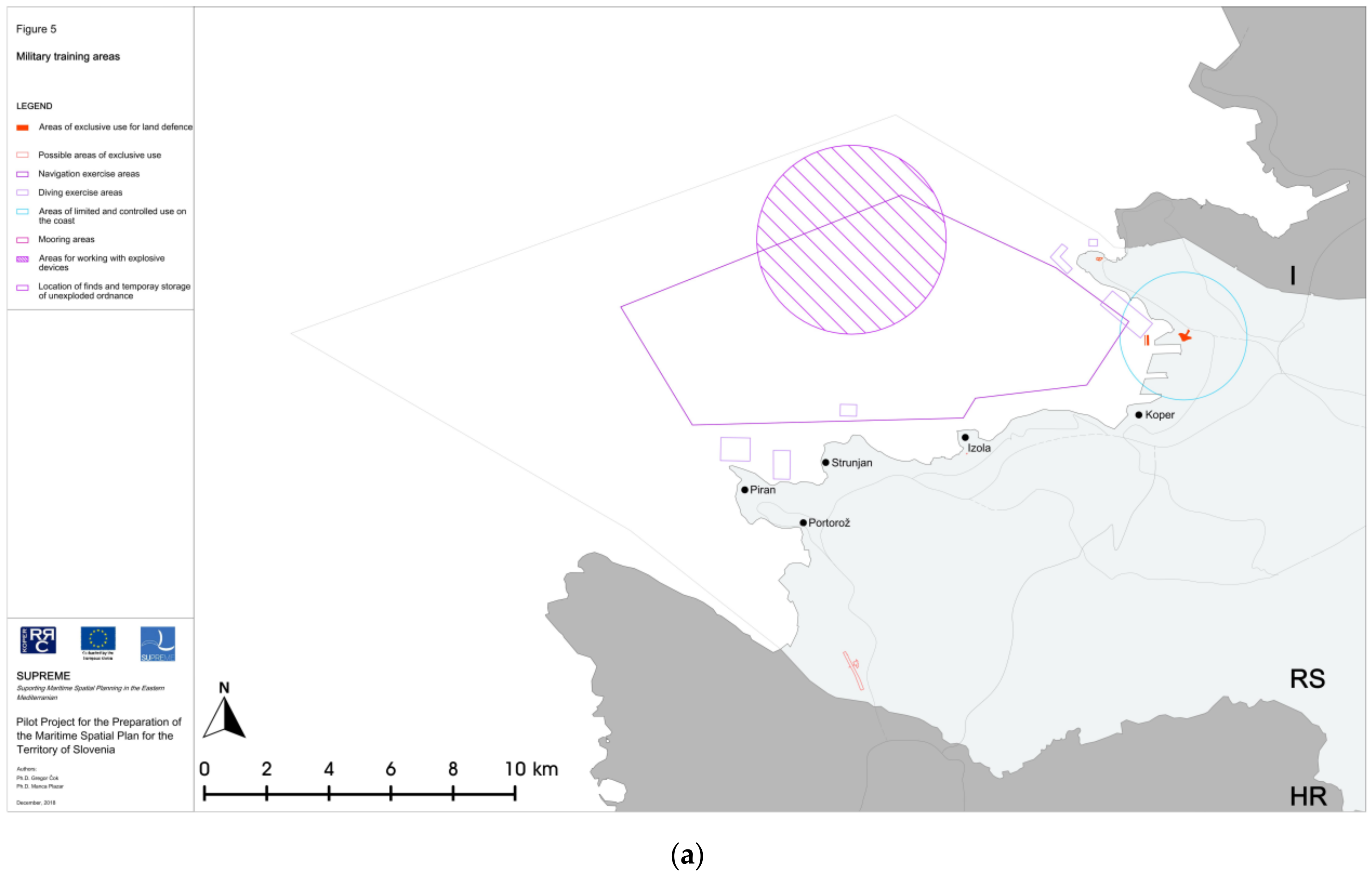
| Defense (military training areas) | - | - | - | - | - | + | + |
| Nature protection (protected areas) | + | + | + | + | + | + | + |
| Exploitation of raw materials | + | + | + | - | + | + | + |
| Scientific research | o | - | - | - | o | + | + |
| Submarine cables and pipelines | - | - | - | + | - | + | + |
| Tourism (tourism infrastructure) | + | + | + | + | + | + | + |
| Cultural heritage (underwater and coastal heritage) | + | + | + | + | + | + | + |
| Urban development (local land–sea interests) | + | + | + | + | + | + | - |
| Identification and application of protocols and tools for the balancing of sea/land interests | *** | *** | *** | ** | ** | *** | *** |
| Administrative Authorities for the Sea and Land | Camp Slovenia | Plancoast | Shape | Adriplan | Adratic+ | Supreme | Portodimare |
|---|---|---|---|---|---|---|---|
| Definition of the water area as a specific spatial planning unit | + | + | o | + | o | + | o |
| Definition of the coastal zone as a specific spatial planning unit | + | + | + | - | + | + | - |
| Definition of land–sea administrative responsibilities (or proposal of revision of the existing) | + | o | + | - | + | + | - |
| International Aspect | Camp Slovenia | Plancoast | Shape | Adriplan | Adratic+ | Supreme | Portodimare |
|---|---|---|---|---|---|---|---|
| Thematic meetings with international participation | *** | ** | ** | ** | * | ** | ** |
| Focus workshops with international participation (coordination) | *** | * | ** | * | * | * | * |
| Public presentations of project results with international participation | *** | ** | * | * | * | * | * |
| Project partner/institution | Camp Slovenia | Plancoast | Shape | Adriplan | Adriatic+ | Supreme | Portodimare |
|---|---|---|---|---|---|---|---|
| 1. Local level (municipality) | 9 | 1 | 0 | 1 | 1 | 0 | 0 |
| 2. Regional level institution | 1 | 6 | 8 | 9 | 3 | 1 | 5 |
| 3. National level (ministry) | 6 | 2 | 1 | 0 | 0 | 3 | 0 |
| 4. Sectoral agency | 4 | 1 | 2 | 0 | 0 | 0 | 2 |
| 5. Non-governmental organization | 1 | 1 | 0 | 0 | 1 | 0 | 0 |
| 6. Research institution | 3 | 3 | 0 | 6 | 3 | 6 | 3 |
| 7. Enterprise (professional) | 0 | 1 | 0 | 1 | 0 | 0 | 0 |
| 8. International organization (UNEP-MAP) | 6 | 1 | 1 | 0 | 0 | 2 | 1 |
| TOTAL number of partners | 30 | 16 | 12 | 17 | 8 | 12 | 11 |
| Portodimare Project Partners | Institution Name and Country |
|---|---|
| Regional level institution | Emilia-Romagna Region, Directorate General for Territory and Environment Protection (IT) |
| Abruzzo Region, Service for Maritime Works and Marine Water (IT) | |
| Apulia Region Department of Civil Protection (IT) | |
| Veneto Region, Environment Directorate—Integrated Water Service and Water Protection Unit (IT) | |
| Regional Development Centre Koper (SLO) | |
| Research institution | CORILA—Consortium for Managing Research Activities in the Venice Lagoon (IT) |
| Hellenic Centre for Marine Research, Institute of Marine Biological Resources and Inland Waters (GRE) | |
| Institute for Physical Planning, Region of Istria (CRO) | |
| Sectoral Agency | Public Enterprise for Coastal Zone Management of Montenegro (MN) |
| Centre for Economic, Technological and Environmental Development Sarajevo (BIH) | |
| International organization | Priority Actions Program Regional Activity Centre (CRO) |
| Databases and Analytical Tools | Camp Slovenia | Plancoast | Shape | Adriplan | Adratic+ | Supreme | Portodimare |
|---|---|---|---|---|---|---|---|
| Database formed for the needs of project implementation | + | + | + | + | o | + | + |
| Geoportal formed (as a project module), publicly available database | o | + | + | + | o | + | + |
| Formed analytical tools (as a project module), publicly available for the purpose of carrying out analyses and spatial solutions | + | - | - | + | + | + | + |
| Level of Contribution | Basic Elements | Detailed Elements |
|---|---|---|
| Procedural Contribution | Establishment of MSP | Development of planning process stages |
| Mobilization of stakeholders and decision-makers | ||
| Implementation of MSP in legislation and practice | ||
| International aspect | ||
| Methodological Contribution | Phases of plan preparation Working methods | Identification of interests (land-sea) |
| Identification of stakeholders and their mobilization | ||
| Balancing of interests | ||
| Development of databases and analytical tools | ||
| Structural Contribution | Design of project content Concrete and partial results | Starting points and objectives of the plan |
| Sectoral fields | ||
| Plan of the maritime uses and activities | ||
| Design for the ICZM coastal zone | ||
| Plan implementation measures | ||
| Financial Contribution | Expert bases Spatial design solutions | Services and products (partially or fully applicable in the draft plan) already paid for |
| Contribution in Terms of Time | Expert bases Spatial design solutions | Services and products (partially or fully applicable in the draft plan) already produced |
Publisher’s Note: MDPI stays neutral with regard to jurisdictional claims in published maps and institutional affiliations. |
© 2021 by the authors. Licensee MDPI, Basel, Switzerland. This article is an open access article distributed under the terms and conditions of the Creative Commons Attribution (CC BY) license (http://creativecommons.org/licenses/by/4.0/).
Share and Cite
Čok, G.; Mezek, S.; Urh, V.; Repe, B. Contribution of International Projects to the Development of Maritime Spatial Planning Structural Elements in the Northern Adriatic: The Experience of Slovenia. Water 2021, 13, 754. https://doi.org/10.3390/w13060754
Čok G, Mezek S, Urh V, Repe B. Contribution of International Projects to the Development of Maritime Spatial Planning Structural Elements in the Northern Adriatic: The Experience of Slovenia. Water. 2021; 13(6):754. https://doi.org/10.3390/w13060754
Chicago/Turabian StyleČok, Gregor, Slavko Mezek, Vane Urh, and Blaž Repe. 2021. "Contribution of International Projects to the Development of Maritime Spatial Planning Structural Elements in the Northern Adriatic: The Experience of Slovenia" Water 13, no. 6: 754. https://doi.org/10.3390/w13060754