
Medieval Relict Beaver Ponds in the Polish Plain: Studies from the Tuchola Forest


Department of Landscape History Research, Institute of Geography, Kazimierz Wielki University, Kościeleckich Square 8, 85-033 Bydgoszcz, Poland
*
Author to whom correspondence should be addressed.
Water 2021, 13(6), 777; https://doi.org/10.3390/w13060777
Submission received: 3 December 2020
/
Revised: 10 March 2021
/
Accepted: 10 March 2021
/
Published: 12 March 2021
(This article belongs to the Special Issue Urban Ecohydrology along the Urban Watershed Continuum: Engineered, Socioecological, and Nature-Based Perspectives)
Abstract
:Beavers have lived in the territory of Poland since the beginning of the Holocene, as testified by bone remains found in archaeological sites of different ages. The area inhabited by these animals has experienced continuing transformations of terrain relief, geological structure, hydrology and plant cover. In Poland, beavers are partially protected and their population has spread in virtually every part of the country (except in the highest mountain ranges). The authors of this paper wish to present the results of field works carried out since 2006 in the Tuchola Forest (Polish Plain). This paper aims to identify the potential sediments of relict beaver ponds and their sedimentological features. The studies are also backed up with a description of radiocarbon dating of samples. The results indicate that beavers used to live in the Tuchola Forest in the Middle Ages, as shown by the radiocarbon dates and sequences of mineral–organic deposits found in exposures and geological boreholes. The spatial distribution of organic and mineral deposits in wider sections of river valleys can be explained by the avulsion of the riverbed downstream of the pond and by the distribution of ponds in the Gołyjonka valley. The discovery of relict beaver pond sediments suggests that the activity of these mammals in the Middle Ages played a major part in shaping the landscape of the valley. The results of studies clearly indicate that analyses of the valley sediment facies of small watercourses should take into account the role beavers played in the past in shaping the landscape of the analysed valley. This highlights the insufficiency of studies concerning the activity of beavers in river valleys.
1. Introduction
The area of the Polish Plain is situated in a temperate forest zone. Beavers appeared in this territory immediately after the last deglaciation when the formation of a forest biome commenced [1,2,3,4]. The best documented period in the history of Holocene beaver colonisation of the territory of Poland is the Middle Ages. Zooarchaeological sources, toponymic materials and written records are available for that period [5,6]. It was a period of early planned wildlife management and protection of beaver habitats.
In the 11th century, King Bolesław Chrobry imposed a ban on beaver hunts on the royal territories. However, due to the large demand for beaver skins and castoreum, a decline in the population of beavers in Poland was noted from the 13th century. An official document offering protection to beavers was the Statutes of Lithuania issued in 1529. The Statutes contained provisions protecting beaver lodges and imposed penalties for violation of the rules. However, it did not specify the number of beavers that could be caught by hunters. Due to the early introduction of protective measures and preservation of natural beaver habitats in Poland, a small number of beavers survived in Poland until the 20th century, in contrast to beaver populations in other places in Europe [7].
As a result of the reconstruction of the beaver population in Poland started in 1946, their number now exceeds 100,000 [8]. The appearance of beavers throughout Poland, including in urbanised areas [9], gave rise to vigorous research among experts in different fields. The scale and manner of impact of beavers on the environment was documented anew [10,11,12,13,14,15,16,17]. Attention was paid to the role of beavers in maintaining a large water storage capacity in river catchment basins [18,19]. Many authors [20,21,22,23,24,25,26] described the scale of changes in contemporary terrain features within the area colonised by beavers and the role of beaver ponds in retaining mineral matter in the bottoms of river valleys. These observations point to the considerable role that beavers must have played in shaping the relief features of small river valleys in the Holocene.
Studies of the Holocene history of river valleys rely to a great extent on knowing how much matter transported by rivers was retained in beaver ponds. At a very early stage, [27,28] noticed a huge share of beaver pond sediments in forming river alluvia.
D. Butler and G.P. Malanson [29], in their studies carried out in the Glacier National Park in Montana, reported that billions of cubic metres of water accumulated in millions of beaver ponds that could have existed in the past. According to [30], in order to recognise relict sediments on flood plains as deriving from beaver ponds, a broader spectrum of corresponding data is needed referring to geomorphological and sedimentological studies carried out in various geographical regions. However, detailed documentation of Holocene relict beaver ponds is still too meagre.
The underlying studies regarding Holocene sediments of relict beaver ponds include the work by [31]. These authors, based on comprehensive studies in Yellowstone National Park, showed that beaver ponds were active throughout the Holocene. Apart from the abovementioned work, other studies exist giving evidence of the accumulation of sediments in beaver ponds. They provide information about wood sticks with beaver teeth marks found in different regions of the world [32,33,34,35,36,37]. The abovementioned wood with beaver cuts was discovered in organic and mineral deposits. Since beavers used to live and have been living in various locations around the world, contemporary analyses of mineral and organic deposits carried out in the polar zone (north Canada) indicate that the activity of beavers contributed to the accumulation of organic deposit in beaver ponds as early as 50,000 years ago [38]. Observations of contemporary activity of beavers in the environment also prompt the use of various research methods, including non-invasive ones. Relict beaver dams and also sediments from relict beaver ponds were documented based on ground-penetrating radar testing [39]. Wood sticks of varying age, bearing beaver teeth marks, were also found in sediment studies [40].
In Poland, studies on the evolution of river valleys in various landscapes of the Vistula and the Oder basins have continued for more than 40 years [41,42,43,44,45,46,47,48,49,50,51,52,53,54,55,56,57,58,59,60]. A summary of Polish studies compared with the achievements of researchers from Central and Eastern Europe was presented by [61]. The processes of erosion and sedimentation occurring in river valleys in the Late Glacial period and in the Holocene were associated with climate changes and starting from the Subboreal also with intensified anthropopressure. Basin sediments were predominantly interpreted as flood sediments. The exception was deposits from mill and fish ponds. Few studies carried out in valleys in Poland documented the presence of beaver pond sediments within Holocene alluvia [4,22,62]. This status of studies is due to serious difficulties in exploring those sediments. The results of studies carried out in small river valleys in the Tuchola Forest indicate that it is necessary to verify the hypotheses on the origin of numerous deposits accumulated on alluvial plains in the Holocene and popularize claims formulated by many researchers about the considerable share of relict beaver pond sediments in materials building the bottoms of river valleys [27,28,29,30,31].
This paper aims to provide an outline of studies carried out so far in the area of the Tuchola Forest (Polish Plain) that were oriented at exploring relict beaver ponds. Sequences of mineral and organic deposits were analysed in the exposures and boreholes in valleys inhabited or abandoned by beavers. The following results form part of a broader study covering sediments of older Holocene ponds as well. Since more recent sediments are more easily available for study (they are deposited at small depths and are better preserved), we have a larger volume of materials for the Middle Ages than for older periods of the Holocene. Investigation for the presence of relict beaver ponds in older periods of the Holocene continues, and the preliminary results were mentioned in the work by [4].
2. Materials and Methods
2.1. Methods
In Poland, studies of Holocene beaver pond sediments have constituted quite a recent line of research [4,22,24]. Gross disparities exist between zooarchaeological evidence of the presence of beavers in Poland in the Holocene collected so far [5,6] and historic records [63], and the documentation regarding beaver habitats in the profiles of Holocene flood plain deposits. Such disparities are especially blatant with regard to the Middle Ages (Figure 1, Table S1 in the Supplementary Materials).
The absence of specific criteria for identifying beaver pond sediments among out-of-channel basin sediments was the main reason for failing to include them in classifications of out-of-channel fluvial facies.
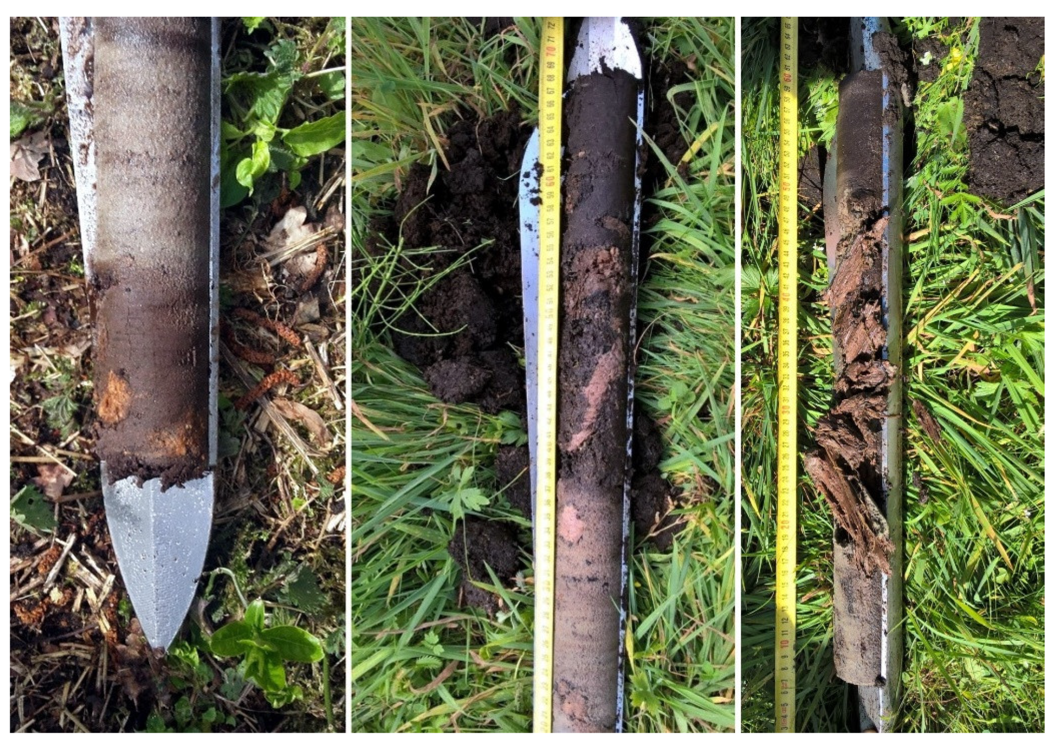
Since 2006, studies have been carried out on selected study sites in the Tuchola Forest investigating the impact of beavers on local habitats, including on water regime, plant cover, terrain relief and sedimentation processes, and the rate of landscape transformation [17,22]. Photographic documentation of changes to the plant cover and terrain relief (beaver paths, tunnels and burrows, landslides) was developed. The surface area of contemporary beaver ponds and beaver dam dimensions were measured. The volume of mineral deposits retained in the ponds was estimated. The sources supplying mineral material to the ponds were identified. Relict beaver pond sediments were documented based on the investigation of exposures and testing of material sampled from Instorf probes produced by Eijkelkamp (Giesbeek, Netherlands). This auger facilitates sampling of 50 cm long undisturbed cores with a diameter of 5 cm and is mainly used for organic deposits sampling. Probing tests were carried out within the peat-covered sections of river valleys. Analyses of beaver pond sediments preserved in the exposures were based on complete structure and texture testing of the mineral fraction and determining the characteristics and age of organic matter.
Because little information is available on identifying beaver pond sediments in river valley sediments, the authors designed their own method for classifying sediments as relict beaver pond facies based on the following criteria:
Structural and texture features typical of sediments from shallow bodies of water. Presence of wood with beaver cuts in sediments found in still bodies of water.
Massive structure and a high share of organic matter are the diagnostic features of sediments found in shallow still bodies of water. Such studies can be carried out in exposures only. Comparison of the results of the analyses of grain-size distribution in contemporary and relict beaver ponds and in contemporary channel (riverbed) sediments shows that, without using other guidelines, the analyses do not make it possible to identify beaver pond sediments among valley bottom sediments [4].
Beaver cuts can be easily identified on wood recovered from exposures. Unfortunately, a predominant portion of Holocene sediments containing wood is deposited below the groundwater table level. Samples of those sediments were obtained for Instorf probe testing, which prevents the identification of beaver cuts. For those sediments, a detailed analysis of macro-remains was useful as it helped identify the presence of allochthonous components dragged by beavers into the pond [17,22].
The sequence of deposits in vertical profiles.
In the vertical profiles in various sections of the wider parts of valleys, an alternating sequence of mineral deposits (river sand), organic–mineral deposits (muds) and organic deposits (peat) was found, followed by mineral deposits, etc. This points to subsequent phases of blocked flow, formation and overgrowth of water reservoirs and the river flow being unblocked again on the study site.
Concentration of wood in sediments tested using Instorf probes.
The analysis aimed at finding relict dams or possibly winter food stores built by beavers. The search for relict accumulations of wood in hydrogenic sediments required dense surveying. Pre-sounding of the valley bottom using a Ground-Penetrating Radar (GPR) was helpful [4,24,39]. Research was conducted with the use of a GPR Detector Duo 250 MHz. Detector Duo made by IDS (Ingegneria dei Sistemi, Pisa, Italy) is a system sending electromagnetic energy as radio waves to check the structure of the soil base. An essential feature of this system is work at frequencies making it possible to identify objects at depths up to 6 m. This detector was used for the first time to identify the concentration of wood in alluvial deposits. The device for detecting wood concentrations in the alluvial layer was tested from the surface to a depth of 2.0 m. The routing signal was sampled and recorded in a digital format. As the ground-penetrating radar moved, subsequent adjoining routes were registered as a graphic record.
In addition, radiocarbon dating results were used, pointing to the presence of mixed wood of varying age in the discovered wood concentrations [4].
Stones in wetland sediments.
Beavers build their dams using wood and other materials they find in the nearest area. Such materials can be mud, turf, bones of large mammals and stones. Some descriptions of dams report the dominance of stones [64,65,66] and dams in which mammoth bones were used as the building material [67]. During the studies carried out in the Tuchola Forest, single stones were found in Holocene reservoir sediments. The stones could have been dragged by beavers in order to reinforce the dam. They could have been introduced into beaver pond sediments either as a result of being lost during transport or after the destruction of the dam.
Considering the abovementioned diagnostic criteria, field surveys were carried out in valley sections presented in Figure 2 and Figure 3. One of the co-authors [17] had previously investigated the geomorphological effects of contemporary beaver colonisation in the selected study area. Samples for laboratory analyses were collected during field surveys. Qualitative analyses of macro-remains were carried out and the content of organic matter was tested for organic deposits. Wood bearing beaver teeth marks (extracted from exposures and Instorf cores from wood debris) and peat were subjected to C14 dating. The content of ash in organic deposits was analysed. Grain-size distribution of the mineral phase and the organic content was analysed in the mineral and organic deposits. The results are given in the description of figure in subpoint 3.1. In special cases, the age of sand samples was determined at the Institute of Physics of the Silesian University of Technology using the OSL (optically stimulated luminescence) method. Technical details of OSL were described by [68,69]. The C14 dating analyses were carried out at the Gliwice Radiocarbon Laboratory, Institute of Physics, Silesian University of Technology (GdS, Gliwice, Poland), using the method described by [70,71,72]. Radiocarbon dating was partially carried out at the Marek Krąpiec Laboratory (MKL, Kraków, Poland). C14 datings were calibrated with the OxCal 4.4 (Oxford Radiocarbon Accelerator Unit, Oxford, UK) [73] programme using the calibration curve IntCal20 [74].
2.2. Study Area
Studies of relict beaver ponds in the Polish Plain were carried out within a section of the Tuchola Forest (Figure 2A,B).
The Tuchola Forest is an extensive forestland situated in the northern part of the Polish Plain in an area mainly built of fluvioglacial sandy outwash sediments from the last glaciation in the Pleistocene. The flat sandy plateau is varied by landforms such as potholes, moraine hills from older stagnant stages and dune hills.
Most of the contemporary valleys are situated in the area of subglacial outflows with potholes formed by dead ice [59,60]. In some wider parts of small valleys in the roof of postglacial fluvial sediments, gyttja and lake chalk remnants are found covered with peat and organic and mineral mud from shallow water reservoirs or bogs. Palynological studies showed that lacustrine sediments formed in that area from at least the beginning of the Holocene [75].
The area of the Tuchola Forest is situated in a temperate climate zone with natural deciduous plants and mixed forest vegetation. The mean temperature ranges here from 6.5 °C to 7.0 °C (3.5 °C in January, and ca. 16.3–17.5 °C in July), and mean precipitation from 560 to 660 mm with predominant levels being recorded in the summer season (350–400 mm).
The primeval wood stand consisting of broadleaved, beechwood and oak forests was a result of intensive anthropogenic transformations that intensified in the 12th and 17th century, and especially in the 19th century, when pines were planted on the edges of the disappearing primeval wood stand.
Beavers settled in the Tuchola Forest with the emergence of the forest biome. The Polish Plain features single Mesolithic sites with the bone remains of Castor fiber [5]. The wood material with beaver cuts found in the alluvia dates back to the last years of the beaver colonisation in the Holocene in the Tuchola Forest [4]. Wood dating shows that beavers used to live in the valleys until the mid-19th century. In 2016, the presence of relict Holocene beaver ponds in the Tuchola Forest was mentioned for the first time [22].
The Holocene alluvia in the territory of the Tuchola Forest were investigated in the valleys of rivers such as the Gołyjonka and Zdrojanka (Figure 2). In the Gołyjonka valley, numerous exposures of relict beaver ponds were found.
3. Results
Studies of the Holocene beaver pond sediments were carried out in small valleys in the Tuchola Forest [4,22]. A representative study area was the area upstream of the Gołyjonka valley.
An upstream section of the valley is a 200 m long V-shaped gorge formed by erosion. Its bottom is up to 10 m wide and its slopes are inclined at an angle of 30–35° (Figure 3). This narrowed section is called the Goły Jon Gorge. The intersected bottom reveals Holocene mineral–organic deposits with wood debris. This is the only place in the valley where sediments from relict beaver ponds could be explored in the exposures.
In the wider sections of the valley, the bottom was a reclaimed area of former swamps. Peat of various origin and varying degree of decomposition as well as peat with interbeddings of sand occur here indigenously to a maximum depth of 5.0–6.0 m. Peat is underlain by gyttja. In wider sections of the valley, where groundwater is found at shallow depths, the studies were carried out based on drilling using Instorf probes.
3.1. Studies in the Goły Jon Gorge
Alongside the Goły Jon Gorge, immediately next to the present-day channel, mineral–organic and organic–mineral pond sediments deposited on riverbed sand and gravel were exposed (Figure 4). In 2015, on an eight-metre-long stretch, a mineral—organic sediment profile was exposed and cleared. The earth works continued in 2017 [4,22]. At present, these sediments make a flood plain that is 10 m wide and 1.5 m to 2.0 m high.
Gorge bottom sections adjoining the wider parts of the valley are filled with peat, sandy peat (loss on ignition from 23% to 86%), highly decomposed peat (loss on ignition 15%) and fine-grained sand (organic C content 1–3.6%). In the remaining area of the gorge, massive dark grey sand occurs with a large fraction of amorphous organic substance containing from 5% to 9% organic C. They show a clear similarity (grain-size distribution and content of organic matter) to sand occurring in the bottom of contemporary beaver ponds. Pieces of wood with beaver teeth marks are found in various locations.
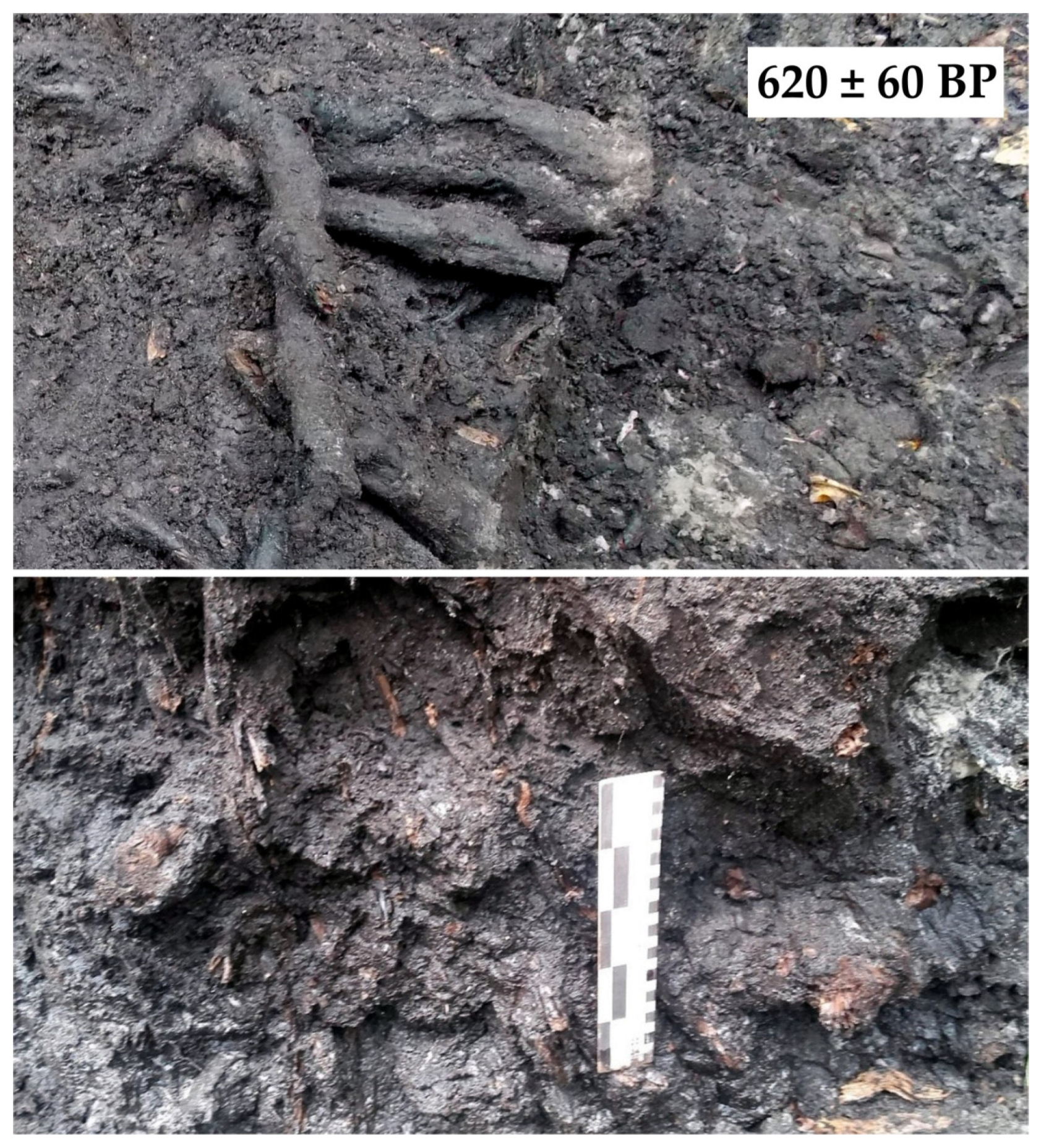
Sediments from the bottom of the gorge consist of two parts. The lower part is riverbed sand containing pieces of wood with beaver cuts. In riverbed sand of the lower part, allogenic wood with beaver cut marks can be found at some points. Two pieces extracted from the same depth were dated as 3220 BP and 1110 BP. The upper element consists of mineral–organic and organic–mineral sediments with plenty of wood detritus. These are sediments found in shallow still bodies of water. In the upper part, the exposure revealed two relict dams (Figure 4). Sand with amorphous organic substance and sand with fine organic detritus is accumulated downstream of the dams, up to dam ceiling level. A piece of wood from the older dam was dated 1450 ± 50 BP (537–668 cal AD). Wood from the more recent dam was dated 620 ± 60 BP (1280–1419 cal AD). In the more recent dam, the distribution of wood was analysed in subsequent horizontal sections (every 15 cm) and in the cross-section (Figure 5). The analysis of the more recent dam demonstrated that only a portion of the structure survived. Near the destroyed relict dam, in the sediments from another relict pond, a stone was found (10 cm wide and 15 cm long).
During the exploration of exposures in the gorge, sediments from five ponds of varying ages were documented. In the sediments from the oldest pond (the deepest lying sediments), an alder tree trunk stuck into its bottom was preserved. It is dated 1550 ± 40 BP (426–596 cal AD) (Table 1), which corresponds to the date of wood from the relict dam built on that pond (1450 ± 50 BP (537–668 cal AD)). The traces of early medieval colonisation were also documented outside the gorge. In the valley suspended over the headwater recess, wood with beaver cuts extracted from sediments of the relict beaver pond was dated 1265 ± 40 BP (663–779 cal AD) [22].
The most recent relict pond (620 ± 60 BP (1280–1419 cal AD)) dates back to the end of the Middle Ages. Radiocarbon dates indicating a medieval sequence of beaver ponds in the Goły Jon Gorge corroborate OSL dating of small portions of riverbed sand separating still water sediments of varying ages (Figure 6 and Figure 7).
3.2. The Gołyjonka Valley. Studies in Wider Parts of the Meltwater Valley
Until the mid-19th century, some parts of the bottom of the Gołyjonka valley were swampy wasteland. Due to recurring land improvement processes, the water table in the bottom of the valley is now 1.0–1.5 m below the ground level. This necessitated geological sounding with Instorf probes. Drilling depth was up to 2.0 m. An exception was single six-metre probes used in the central part of the peat bog in the wider headwaters section of the river Gołyjonka. The structure of the studied organic cover differs from the classic structure of peatland formed by lake overgrowth. The accumulation of peat in wider sections of valleys first started in the central part. The swamp-forming process extended onto the external parts of valleys much later. The classic pattern of evolution of river valley peatland is disturbed by local accumulation of riverbed sand separating peat, highly decomposed peat and lens-shaped accumulations of wood.
These are sequences of sediments formed when channel flows are dammed and are later reactivated in the same place, i.e., fluvial sand–peat–fluvial sand (Figure 8 and Figure 9). The accumulation of wood debris in certain cases was ascribed to the activity of beavers.
3.2.1. Sand Separating Layers of Peat
The following results were obtained during probe testing in wider sections of the Gołyjonka valley:
Out of 47 cores in which sand was found, 13 contained sand on peat deposits. In other cores, sand is deposited in the floor, immediately on lacustrine sediments. The layer of organic mud and peat deposited on riverbed sand is typical of the stage of overgrowth of the body of water formed on the river channel after a dam was built by beavers. Alternating sand–peat–sand sequences discovered in the cores are interpreted as the result of stopping the flow, formation of a beaver pond, its overgrowth and reappearance of a river channel in this place.
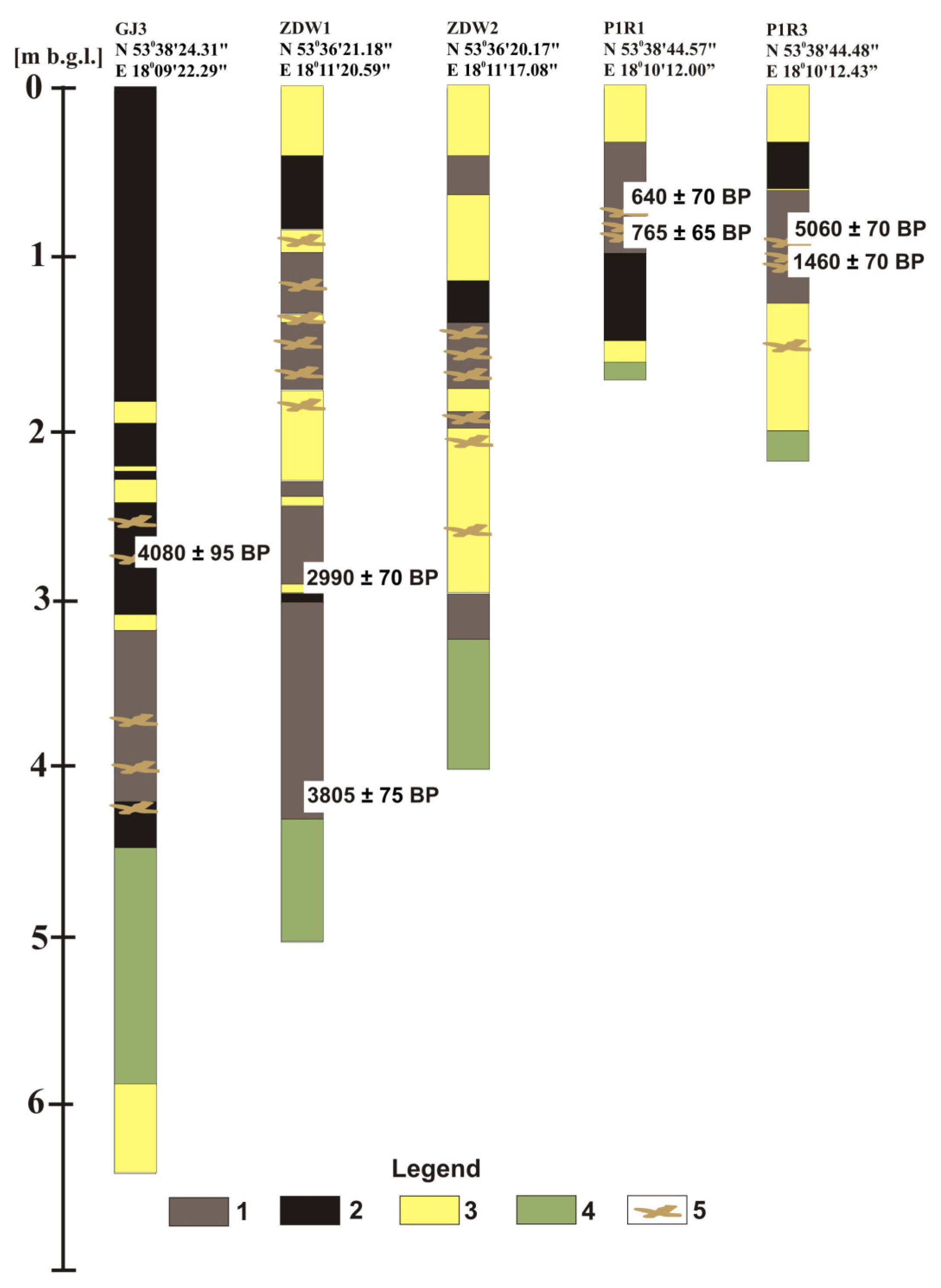
In the outer parts of the valley bottom, the thickness of organic–mineral deposits containing beaver pond sediment sequences does not exceed 2.0 m. The prevailing mass of sediments in the marginal zone formed in the Subatlantic period. The radiocarbon date of a wood sample found at a depth of 1.7 m is 1855 ± 45 BP (70–255 cal AD). Muck samples from a depth of 2.0 m were dated 2420 ± 60 BP (672–397 cal BC). There are reasons to believe that, in the central sections of the valley bottom, this young cover may be inserted into the intersected parts of older covers. This is testified by the date of wood dragged from older deposits into the beaver dam built probably 1500 years ago (allochthonous wood dated 5060 ± 70 BP (3983–3702 cal BC) is deposited in the wood debris 30 cm above wood dated 1460 ± 70 BP (428–674 cal AD) (Figure 9)). Sediments predominant in the analysed two-metre-thick layer are typical of beaver ponds (six radiocarbon datings of wood from pond sediments within the range 640–1550 BP (Figure 9, Table 1)). The radiocarbon dates of formations found at a depth from 0.5 m to 1.0 m were determined in a period from 640 ± 70 BP (1266–1425 cal AD) to 765 ± 65 BP (1156–1322 cal AD) (late Middle Ages) and those at a depth of 1.0–1.5 m from 1290 to 1550 BP (early Middle Ages).
In the central wider sections of valleys, the layer of wetland sediments deposited on lacustrine sediments (gyttja) is slightly thicker than 4.0 m. In ZDW1 core (Figure 9), undistributed sedge peat from a depth of 4.3 m was dated 3805 ± 75 BP (2465–2110 cal BC). In the “headwaters basin” (Figure 9, GJ3 core), the oldest sands testifying that the basin formed part of a river network were older than 4080 ± 95 BP (2895–2451 cal BC) (in a similar wider section of the Zdrojanka valley, sands from the oldest channel flow were older than 2990 ± 70 BP (1410–1042 cal BC)).
In the core reaching a depth of 5.0 m in the wider part of the Zdrojanka valley (Figure 9, ZDW1 core, location shown in Figure 2), the sediments of beaver ponds are accumulated in a 1 m thick layer of highly decomposed peat from ca. 3805 ± 75 BP (2465–2110 cal BC) to ca. 3000 BP. From a depth of about 3.0 m (3000 BP) up to the ceiling, there is a series of alternating peat and sand layers including seven inserts of riverbed sand separating peat from organic–mineral silt. The origin other than that connected with the cycles: beaver pond > filling with organic formations during pond disappearance > cutting of the fill by the river channel > repeated stopping of the flow, is hardly acceptable.
In the central part of the headwaters of the river Gołyjonka, 4.7 m thick layers of peat decomposed to a different degree and deposited on sand were drilled. At a distance of 30 m, another hole was drilled in which alternating sand and peat layers were found up to a depth of 3.65 m (four sandy interbeddings from 5 to 15 cm thick). Wood occurring at a depth of 285 cm was dated 4080 ± 95 BP (2895–2451 cal BC) (Figure 9. GJ3 core). The recurring location of beaver ponds in this place for at least four thousand years and accumulation of the peat cover in the bottom next to them testify to certain preferences of beavers in selecting dam locations and the lack of lateral migration of the river channel.
Dams built on rivers contributed to avulsion and formation of new river channels (Figure 10). Initially, avulsion covered a narrow zone of the valley axis. Only when the central parts of the postglacial depressions were filled with Holocene organic–mineral sediments did the zone in which beaver ponds were formed and the related avulsion extend onto their marginal parts.
3.2.2. Wood in Peat and Sand
Studies carried out in contemporary ponds and in exposed relict ponds in the Goły Jon Gorge revealed an increase in the concentration of wood in the area directly used by beavers [4,22]. Wood accumulated in wetland sediments was initially detected based on anomalies on GPR images of the area. Based on those images, possible wood concentration sites in the settlements were selected for Instorf probing tests. The forest peat–sand–forest peat sequences were associated with relict beaver ponds. Another element that was probably connected with beaver ponds (remnants of dams) was layers of wood debris more than 30 cm thick. The cores in which macro-remains were analysed proved useful for revealing the presence of beavers in wider parts of the valleys and the presence of allochthonous wood was confirmed.
4. Discussion
The material presented in this article is a report from a part of research carried out in the search for relict beaver ponds from the Holocene in the Tuchola Forest. The first stage of research comprised studies of how beaver activity currently affects changes in the components of the environment. Contemporary changes of terrain relief, sedimentation, water storage, plant cover and biodiversity connected with the presence of beavers were analysed [22]. Results obtained at this stage triggered a search for past traces of beaver activity.
The relatively small number of papers dealing with issues connected with beaver activity in the Holocene is mainly due to problems with the selection of methods for correct identification of beaver pond sediments. The likelihood of finding Holocene beaver pond sediments in exposures within the Tuchola Forest is low due to the fact that Holocene sediments are mostly found below the groundwater table level. The effectiveness of studies carried out in cleared exposures with accumulations of wood bearing beaver teeth marks is indisputable. Positive results were obtained during studies carried out in exposures in the Goły Jon Gorge.
The study of the only profile of relict beaver ponds so far in Poland and its comparison with profiles described by other researchers [31] shows that unambiguous sedimentological criteria for identifying the sediments of relict beaver ponds do not exist. Wood with beaver teeth marks found in the exposures is a very valuable material as it makes the beaver origin of pond sediments probable.
Certain classical methods used in river valley sediment studies are fallible. These include structural and texture analysis of sediment features (e.g., grain-size distribution analysis).
Serious problems occur in recognising beaver pond sediments during field surveys in wider sections of valleys filled with peat. Difficulties emerge at the stage of selecting the survey site in a flat area covered with peat. Non-invasive testing methods using Detector Duo were effective in only half. Based on changes in the dry density of sediments and other features, the team of N. Kramer were able to determine the sites for detailed analysis and identify relict beaver dams [39]. During our studies, in places where the ground-penetrating radar detected density disruptions in 50% of the cases, the accumulations of wood debris were recognised as the reason for such disruption (corroborated by Instorf probe testing).
A difficult-to-specify but certainly large number of probes would be required in order to identify sites in a flat peatland with a surface area of a few hectares where, at the most, several-metres-wide beaver dams could have been preserved underground at different depths without a ground-penetrating radar—even one with 50% efficiency.
Studies carried out in peat bogs involved sedimentary facies analysis using sequence stratigraphy. Formations characteristic of an overgrown body of water overlaying the riverbed sand point to a high likelihood that the flow in the stream was dammed and a pond created. The beaver origin of such damming is probable according to accompanying analyses (analysis of macro-remains and radiocarbon dating). Section A of Figure 11 illustrates a situation when the river channel is directed onto the peat surface due to avulsion. Riverbed sand is accumulated on peat (see probe in Figure 8). Stopping of the water flow by a beaver dam leads to the formation of a temporary pond filled with wood detritus and later with peat. Probe testing carried out in the peat bogs showed similar sequences recurring at different depths for a number of probes (Figure 9). To a depth of 2.0 m, the sequences dated back to the Middle Ages. In single probes, older sequences were found at greater depths (from the beginning of the Subboreal period). It is very likely only a matter of time before beaver ponds older than Subboreal in the central parts of peat bogs featuring the thickest wetland formations are documented.
The activity of beavers was manifested in adapting the environment to their needs by building dams which raised the level of water in the watercourse. The internal structure of beaver dams is very complex. Beavers build dams using various materials, e.g., wood, sediments, grass, leaves and stones [64,65,66]. Generally, beavers use anything that is available near their habitat. Beaver dams contain stones which can be the indicators of beaver activity. In the Goły Jon Gorge, in a layer of organic deposits, a stone was found which should be associated with the activity of beavers. The study site is surrounded by an area built of fluvioglacial sediments with prevailing fractions of sand. The drilling found no fraction thicker than medium-grained sand, which suggests that beavers brought this stone from another location.
The flooding of river valleys and formation of peat cover commonly occurring in the Holocene has so far been associated with climate change or anthropopressure. Identifying beaver activity as a factor triggering changes similar to those inspired by the climate or human activity compounds the paleogeographic interpretations of the Holocene evolution of small river valleys in the Polish Plain.
5. Conclusions
The only exposure of relict beaver ponds that has been known in Poland is located in the Gołyjonka valley. It was also the first time when the Holocene valley peat cover was explored in the search for relict beaver ponds. Based on analysis of the sequence of channel deposits and sediments of shallow overgrown ponds and radiocarbon dating of wood bearing beaver teeth marks, it was determined that medieval beaver ponds were present in peat-covered sections of river valleys.
Procedures concerning the use of various indicators useful in identifying beaver pond sediments in alluvial deposits were described. They can be used for carrying out studies in small river valleys in other areas. In exposures, next to structural and texture analyses, the prevailing criterion is the presence of wood bearing beaver teeth marks. In valley peat cover surveys, the fundamental criterion for recognising relict beaver pond sediments is the alternating layers of channel deposits and sediments of shallow still bodies of water. An additional criterion can be the presence of macro-remains of allochthonous wood among wood debris. Stones were hardly ever found in pond sediments.
The oldest beaver ponds found in the Tuchola Forest dated back to the Subboreal period [4]. Documenting older deposits is an open research issue due to the fragmentary nature of material collected so far. The preparation of cores is planned in the central parts of wider sections of the valley where the layer of Holocene sediments is the thickest.
A clear need arises for including beaver pond sediments in the classification of river basin sediments and describing them in detail. However, this requires a larger set of data on variations in their features depending on the environmental conditions in the catchment basins in which such ponds occur.
Documenting the presence of beavers in forest catchments in the Holocene is also significant in terms of evaluating the role of these rodents in mitigating the effect of climate change on the water regime of river basins at that time.
Supplementary Materials
The following are available online at https://www.mdpi.com/2073-4441/13/6/777/s1, Table S1: List of cities and towns names derived from the word “beaver”.
Author Contributions
Conceptualization, Z.Ś. and M.R.; methodology, Z.Ś. and M.R.; software, M.R.; data curation, M.R.; writing—original draft preparation, Z.Ś., M.R. and M.H.; writing—review and editing, M.R. and M.H.; visualization, M.R. All authors have read and agreed to the published version of the manuscript.
Funding
The laboratory analyses (C14 radiocarbon dating) were financed by the National Science Center from the Miniatura 1 project, project number 2017/01/X/ST10/01060. This research and APC were funded by the Project Supporting Maintenance of the Research Potential of the Institute of Geography at the Kazimierz Wielki University (grant number BS/2016/N1).
Institutional Review Board Statement
Not applicable.
Informed Consent Statement
Not applicable.
Data Availability Statement
The data presented in this study are available on the request from the corresponding author.
Acknowledgments
The manuscript has been reviewed by anonymous reviewers and editors, who are gratefully acknowledged for their constructive criticism and suggestions.
Conflicts of Interest
The authors declare no conflict of interest.
References
- Kowalewska-Marszałek, H.; Włodarczyk, P. Wyniki badań powierzchniowych na stanowisku paleolitycznym w Wilczycach, powiat Sandomierz. Sprawozdania Archeologiczne 2002, 54, 21–60. [Google Scholar]
- Fiedorczuk, J.; Bratlund, B.; Kolstrup, E.; Schild, R. Late Magdalenian Feminine Flint Plaquettes from Poland. Antiquity 2007, 81, 97–105. [Google Scholar] [CrossRef]
- Bałaga, K.; Hołub, B.; Kusiak, J.; Łanczont, M.; Mroczek, P.; Zielinski, P.; Komar, M. Próba rekonstrukcji rzeźby terenu i środowiska z okresu funkcjonowania późnomagdlaeńskiego obozowiska w Wilczycach (Wyżyna Sandomierska). Landf. Anal. 2008, 9, 269–271. [Google Scholar]
- Śnieszko, Z.; Rurek, M.; Hojan, M. The Role of Beavers in the Holocene Landscape Evolution of the Small River Valleys (the Tuchola Forest—North European Plain); Kazimierz Wielki Univeristy Press: Bydgoszcz, Poland, 2020; pp. 1–109. ISBN 978-83-8018-344-5. [Google Scholar]
- Abłamowicz, D.; Rurek, M.; Śnieszko, Z. Znaczenie badań skutków obecności bobrów w pradziejach dla lokalnych i regionalnych rekonstrukcji paleogeograficznych. In 3rd Symposium of Environmental Archaeology, Archaeozoological Research in Poland and Middle—East Europe, Data—Methods—Interpretations; Makowiecki, D., Abłamowicz, R., Abłamowicz, D., Smiarowski, K., Makohonienko, M., Eds.; conference edition; Bogucki Wydawnictwo Naukowe: Katowice-Koszęcin, Poland, 2008; pp. 35–36. ISBN 978-83-61320-30-2. [Google Scholar]
- Makowiecki, D.; Wiejacki, J. Bóbr w krajobrazie przyrodniczo kulturowym holocenu w świetle przesłanek archeozoologicznych. In Bobry w Rezerwacie Biosfery Bory Tucholskie. Przeszłość, Teraźniejszość, Perspektywy; Streszczenia referatów, Instytut Geografii UKW: Stara Kiszewa-Bydgoszcz, Poland, 2015; pp. 16–17, not published. [Google Scholar]
- Czech, A. Bóbr. Monografie Przyrodnicze; Wyd. Lubelskiego Klubu Przyrodników: Świebodzin, Poland, 2000; pp. 1–99. ISBN 83-87846-15-5. [Google Scholar]
- Wróbel, M. Population of Eurasian beaver (Castor fiber) in Europe. Short Communication. Glob. Ecol. Conserv. 2020, 23. [Google Scholar] [CrossRef]
- Bereszyński, A.; Homan, E. Występowanie bobra europejskiego (Castor fiber Linnaeus, 1758) w Poznaniu. Nauka Przyroda Technologie 2007, 1, 1–43. [Google Scholar]
- Soja, R. Środowiskowe skutki reintrodukcji bobra (Castor fiber) w doliny rzek Karpackich. In Przewodnik Konferencji “Funkcjonowanie Geosystemów Dolinnych w Warunkach Zmian Klimatu i Narastania Antropopresji Późnego Glacjału i Holocenu”; Wydział Nauk o Ziemi Uniwersytetu Śląskiego: Sosnowiec, Poland, 1996; pp. 45–46. [Google Scholar]
- Witt, A. Wpływ stawów bobrowych na rozwinięcie małych koryt rzecznych w Wielkopolsce północnej. Dorobek i pozycja polskiej geomorfologii u progu XXI wieku. In V Zjazd Geomorfologów Polskich, Streszczenia Referatów; Wydawnictwo UMK: Toruń, Poland, 2000; pp. 142–143. [Google Scholar]
- Kobojek, E. Środowiskowe skutki reintrodukcji bobra (Castor fiber) w dolinie Rawki. Przegląd Geograficzny 2005, 77, 383–396. [Google Scholar]
- Kobojek, E. Wpływ działalności bobrów na lokalne procesy fluwialne w wybranych rzekach równiny łowicko-błońskiej. Acta Universitatis Lodziensis Folia Geographica Physica 2013, 12, 17–22. [Google Scholar]
- Stopka, R. Geomorfologiczne skutki działalności bobra europejskiego Castor fiber w dolinie górnego Sanu. Roczniki Bieszczadzkie 2011, 19, 319–334. [Google Scholar]
- Rurek, M. Zmiany środowiska przyrodniczego związane z obecnością bobra (Castor fiber) w dolinach Gajdówki i Zdrojanki (pd. Bory Tucholskie). Promotio Geographia Bydgostiensia 2012, 5, 153–165. [Google Scholar]
- Rurek, M. Wpływ działalności bobra (Castor fiber L. 1758) na przemiany holoceńskiego krajobrazu w południowej części Borów Tucholskich. Ph.D. Thesis, Biblioteka WNoZ UŚ, Sosnowiec, Poland, 2013; pp. 1–161. [Google Scholar]
- Rurek, M. Lokalne zmiany środowiska przyrodniczego wywołane działalnością bobra europejskiego (Castor fiber L.) w okolicy Trzebcin (powiat tucholski). J. Health Sci. 2013, 3, 247–256. [Google Scholar]
- Grygoruk, M. Metodyka szacowania objętości retencyjnej stawów bobrowych oraz ich oddziaływania na stosunki wodne zlewni leśnych. Studia i Materiały Centrum Edukacji Przyrodniczo-Leśnej Year 10 2008, 2, 162–172. [Google Scholar]
- Grygoruk, M.; Nowak, M. Spatial and temporal variability of channel retention in a lowland temperate forest stream settled by European beaver (Castor fiber). Forests 2014, 5, 2276–2288. [Google Scholar] [CrossRef]
- Szpikowska, G.; Szpikowski, J. Właściwości fizykochemiczne wód rozlewisk bobrowych w dolinie Kłudy (górna Parsęta). Monitoring Środowiska Przyrodniczego 2012, 3, 95–102. [Google Scholar]
- Giriat, D.; Gorczyca, E.; Sobucki, M. Beaver ponds’ impact on fluvial processes (Beskid Niski Mts., SE Poland). Sci. Total Environ. 2016, 544, 339–353. [Google Scholar] [CrossRef] [PubMed]
- Rurek, M.; Śnieszko, Z.; Makohonienko, M. Contemporary and Fossil Beaver Ponds in Small River Valleys on the Area of Bory Tucholskie (North European Plain); [in Polish with English summary]; Kazimierz Wielki University Press: Bydgoszcz, Poland, 2016; pp. 1–136. ISBN 978-83-8018-109-0. [Google Scholar]
- Fajer, M.; Malik, I.; Waga, J.M.; Wistuba, M.; Woskowicz-Ślęzak, B. Współczesne wykorzystanie przez bobra europejskiego Castor fiber antropogenicznie przekształconych dolin rzecznych (przykłady z Równiny Opolskiej i Wyżyny Woźnicko-Wieluńskiej). Contemporary adaptation of anthropogenically- transformed river valleys by European beavers Castor fiber (examples from Poland’s Opole Plain and Woźniki-Wieluń Upland). Przegląd Geograficzny 2017, 89, 467–489. [Google Scholar] [CrossRef] [Green Version]
- Śnieszko, Z.; Rurek, M.; Rzętała, M. Significance of relief-forming activities by Castor fiber L. for the evolution of Holocene floodplains of small river valleys (results of studies conducted in Poland). In Proceedings of the 17th International Multidisciplinary Scientific GeoConference (SGEM 2017), Albena, Bulgaria, 29 June–5 July 2017; Volume 17, pp. 523–529. [Google Scholar] [CrossRef]
- Gorczyca, E.; Krzemień, K.; Sobucki, M.; Jarzyna, K. Can beaver impact promote river renaturalization? The example of the Raba River, southern Poland. Sci. Total Environ. 2018, 615, 1048–1060. [Google Scholar] [CrossRef] [PubMed]
- Szpikowski, J.; Szpikowska, G. Akumulacja osadów w rozlewiskach bobrowych w świetle oceny wielkości denudacji mechanicznej zlewni młodoglacjalnej (Kłuda, Pomorze Zachodnie). In Geneza, Litologia i Stratygrafia Utworów Czwartorzędowych; Kostrzewski, A., Stach, A., Majewski, M., Eds.; Wydawnictwo UAM w Poznaniu: Poznań, Poland, 2018; Volume 7, pp. 197–204. ISBN 978-83-936793-0-0. [Google Scholar]
- Ruedemann, R.; Schoonmaker, W.J. Beaver-dams as geologic agents. Science 1938, 88, 523–525. [Google Scholar] [CrossRef]
- Ives, R.L. The beaver–meadow complex. J. Geomorphol. 1942, 5, 191–203. [Google Scholar]
- Butler, D.R.; Malanson, G.P. The geomorphic influences of beaver dams and failures of beaver dams. Geomorphology 2005, 71, 48–60. [Google Scholar] [CrossRef]
- Hajic, E.R.; Walz, G.R. Evidence of prehistoric beaver activity in the Des Plaines River valley, Illinois. Tech. Pap. 2000, 8, 3–11. [Google Scholar]
- Persico, L.; Meyer, G. Natural and historical variability in fluvial processes Beaver activity, and climate in the Greater Yellowstone Ecosystem. Earth Surf. Process. Landf. 2013, 38, 726–750. [Google Scholar] [CrossRef]
- Garrison, G.C. Pollen stratigraphy and age of an early postglacial beaver site near Columbus, Ohio. Ohio J. Sci. 1967, 7, 96–105. [Google Scholar]
- Aalto, M.J.; Hirvas, H.; Niemelä, J. An interglacial beaver dam deposit at Vimpeli, Ostrobothnia, Finland. Geol. Surv. Finland 1989, 348, 1–34. [Google Scholar]
- Wells, C.E.; Hodgkinson, D.; Huckerby, E. Evidence for the possible role of beaver (Castor fiber) in the prehistoric ontogenesis of a mire in north-west England, UK. Holocene 2000, 10, 503–508. [Google Scholar] [CrossRef]
- Robinson, S.; Beaudoin, A.B.; Froese, D.G.; Doubt, J.; Clague, J.J. Plant Macrofossils Associated with an Early Holocene Beaver Dam in Interior Alaska. Arctic 2007, 60, 430–438. [Google Scholar] [CrossRef] [Green Version]
- Yansa, C.H.; Jacobs, P.M. Pleistocene-age-giant beaver (Castoroides Ohioensis) and extant beaver (Castor Canadiensis) environments of southern Wisconsin. Geol. Soc. Am. Abstr. Program. 2009, 41, 1–257. [Google Scholar]
- De Visscher, M.; Nyssen, J.; Pontzeele, J.; Billi, P.; Frankl, A. Spatio-temporal sedimentation patterns in beaver ponds along the Chevral river, Ardennes, Belgium. Hydrol. Process 2014, 28, 1602–1615. [Google Scholar] [CrossRef] [Green Version]
- Mitchel, W.T.; Rybczynski, N.; Schröder-Adams, C.; Hamilton, P.B.; Smith, R.; Douglas, M. Stratigraphic and Paleoenvironmental Reconstruction of a Mid-Pliocene Fossil Site in the High Arctic (Ellesmere Island, Nunavut): Evidence of an Ancient Peatland with Beaver Activity. ARCTIC 2016, 69, 185–204. [Google Scholar] [CrossRef]
- Kramer, N.; Wohl, E.E.; Harry, D.L. Using ground penetrating radar to ‘unearth’ buried beaver dams. Geology 2012, 40, 43–46. [Google Scholar] [CrossRef] [Green Version]
- James, C.D.; Lanman, R.B. Novel physical evidence that beaver historically were native to the Sierra Nevada. California Fish Game 2012, 98, 129–132. [Google Scholar]
- Kozarski, S.; Rotnicki, K. Problemy późnowurmskiego i holoceńskiego rozwoju den dolinnych na Niżu Polskim. Prace Komisji Geograficzno-Geologicznej PTPN 1978, 19, 1–57. [Google Scholar]
- Starkel, L. (Ed.) Evolution of the Vistula River Valley During the Last 15000 Years; Geographical Studies; Ossolineum: Wrocław, Poland, 1982; Volume SI1, pp. 1–169. [Google Scholar]
- Starkel, L. (Ed.) Evolution of the Vistula River Valley During the Last 15000 Years; Geographical Studies; Ossolineum: Wrocław, Poland, 1982; Volume SI4, pp. 1–252. [Google Scholar]
- Starkel, L. (Ed.) Evolution of the Vistula River Valley During the Last 15000 Years; Geographical Studies; Ossolineum: Wrocław, Poland, 1990; Volume SI5, pp. 1–220. [Google Scholar]
- Starkel, L. (Ed.) Evolution of the Vistula River Valley During the Last 15000 Years; Geographical Studies; Ossolineum: Wrocław, Poland, 1991; Volume SI6, pp. 1–154. [Google Scholar]
- Starkel, L. (Ed.) Evolution of the Vistula River Valley During the Last 15000 Years; Geographical Studies; Ossolineum: Wrocław, Poland, 1995; Volume SI8, pp. 1–156. [Google Scholar]
- Starkel, L. Historia doliny Wisły od ostatniego zlodowacenia do dziś. Monografie IGIPZ PAN 2001, 2, 1–263. [Google Scholar]
- Szumański, A. Paleochannels of large meanders in the river valleys of the Polish Lowland. Quaternary Stud. Poland 1983, 4, 207–216. [Google Scholar]
- Szumański, A. Postglacjalna ewolucja i mechanizm transformacji dna doliny dolnego Sanu. Kwart. AGH, Geologia 1986, 12, 1–92. [Google Scholar]
- Andrzejewski, L. Dolina Zgłowiączki—Jej geneza oraz rozwój w późnym vistulianie i holocenie. Dokumentacja Geograficzna 1984, 3, 1–84. [Google Scholar]
- Śnieszko, Z. Paleogeografia holocenu w dolinie Sancygniówki (Acta Geographica Lodziensia); Zakład Narodowy im. Ossolińskich: Wrocław, Poland, 1985; Volume 51, pp. 1–107. ISBN 83-04018-86-1. [Google Scholar]
- Śnieszko, Z. Ewolucja Obszarów Lessowych Wyżyn Polskich w Czasie Ostatnich 15000 lat; Wydawnictwo Uniwersytetu Śląskiego: Katowice, Poland, 1995; Volume 1496, pp. 1–124. ISBN 83-22606-23-0. [Google Scholar]
- Teisseyre, A.K. Mady dolin sudeckich, cz.I. Ogólna charakterystyka środowiska (na przykładzie zlewni górnego Bobru). Geologica Sudetica 1985, 20, 113–195. [Google Scholar]
- Teisseyre, A.K. Mady dolin sudeckich, cz.II. Wybrane zagadnienia metodologiczne. Geologica Sudetica 1988, 23, 65–101. [Google Scholar]
- Rotnicki, K.; Młynarczyk, Z. Późnovistuliańskie i holoceńskie formy i osady korytowe w dolinie środkowej Prosny i ich paleohydrologiczna interpretacja. Geografia; UAM: Poznań, Poland, 1989; pp. 1–76. ISBN 83-23201-68-4. [Google Scholar]
- Florek, W. Postglacjalny Rozwój Dolin Rzek Środkowej Części Północnego Skłonu Pomorza; WSP: Słupsk, Poland, 1991; pp. 1–238. [Google Scholar]
- Rotnicki, K. Reconstruction of palaeodischarges of meandering and sinuous alluvial rivers and its palaeohydroclimatic implications. In Temperate Palaeohydrology; Starkel, L., Gregory, K.J., Thornes, J.B., Eds.; Willey: Chichester, UK, 1991; pp. 431–471. [Google Scholar]
- Błaszkiewicz, M. Dolina Wierzycy, jej geneza oraz rozwój w późnym plejstocenie i wczesnym holocenie; Dokumentacja Geograficzna; Stanislaw Leszczycki Institute of Geography and Spatial Organization Polish Academy of Science: Warszawa, Poland, 1998; Volume 10, pp. 1–116. ISBN 83-86682-26-4. [Google Scholar]
- Błaszkiewicz, M. Późnoglacjalna i Wczesno Holoceńska Ewolucja Obniżeń Jeziornych na Pojezierzu Kociewskim (Wschodnia część Pomorza); Prace Geograficzne IGIPZ PAN: Warszawa, Poland, 2005; pp. 1–192. ISBN 83-87954-56-X. [Google Scholar]
- Andrzejewski, L.; Krzemień, K.; Zwoliński, Z. Outline of natural and anthropogenic determinants for the evolution of valley and river channel systems in Poland. Landf. Anal. 2018, 37, 17–51. [Google Scholar] [CrossRef]
- Kalicki, T. Zapis Zmian Klimatu Oraz Działalności Człowieka i Ich Rola w Holoceńskiej Ewolucji Dolin Środkowoeuropejskich; Prace Geograficzne IGiPZ PAN: Warszawa, Poland, 2006; pp. 1–348. ISBN 83-87954-58-6. [Google Scholar]
- Abłamowicz, D.; Śnieszko, Z. Zmiany środowiska w okresie subatlantycki w dolinie Czarnej Przemszy w Wojkowicach Kościelnych koło Siewierza (Wyżyna Śląska). Wstępne wyniki badań. In Środowisko—Człowiek—Cywilizacja 2; Romańska, L., Kittel, P., Forysiak, J., Eds.; Bogucki Wydawnictwo Naukowe: Poznań, Poland, 2009; pp. 301–312. [Google Scholar]
- Samsonowicz, A. Łowiectwo w Polsce Piastów i Jagiellonów; Warszawska Firma Wydawnicza s.c.: Warszawa, Poland, 2011; pp. 1–137. ISBN 978-83-61748-86-1. [Google Scholar]
- Dugmore, A.R. The Romance of the Beaver, Being the History of the Beaver in the Western Hemisphere; J.B. Lippincott Company: Philadelphia, PA, USA; William Heinemann: London, UK, 1914. [Google Scholar]
- Jung, T.S.; Staniforth, J.A. Unusual Beaver, Castor canadensis, Dams in Central Yukon. Can. Fld. Nat. 2010, 124, 274–275. [Google Scholar] [CrossRef] [Green Version]
- Müller, G.G.; Watling, J. The engineering in beaver dams. In Proceedings of the River Flow 2016: Eighth International Conference on Fluvial Hydraulics, St. Louis, MO, USA, 12–15 July 2016; pp. 1–7. [Google Scholar]
- Yukon Government. 125.000-Year-Old Beaver Dam Unearthed Near Old Crow, 05-297. 18 November 2005. Available online: http://www.gov.yk.ca/news/2005/05-297.html (accessed on 20 November 2020).
- Poręba, G.; Śnieszko, Z.; Moska, P.; Mroczek, P.; Malik, I. Interpretation of soil erosion a Polish loess area using OSL, 137Cs, 210Pbex, Dendrochonology and micromorphology—Case study: Biedrzykowice site (S Poland). Geochronometria 2019, 46, 57–78. [Google Scholar] [CrossRef] [Green Version]
- Poręba, G.; Śnieszko, Z.; Moska, P.; Mroczek, P. Deposits of Neolithic water soil erosion in the loess region of the Małopolska Upland (S Poland)—A case study of the settlement micro-region in Bronocice. Quaternary Int. 2019, 502, 45–59. [Google Scholar] [CrossRef]
- Pazdur, A.; Fogtman, M.; Michczyński, A.; Pawlyta, J. Precision of 14C dating in Gliwice radiocarbon laboratory. FIRI Programme. Geochronometria 2003, 22, 27–40. [Google Scholar]
- Tudyka, K.; Pazdur, A.; Theodórsson, P.; Michczyński, A.; Pawlyta, J. The Application of ICELS Systems for Radiocarbon Dating. Radiocarbon 2010, 52, 1661–1666. [Google Scholar] [CrossRef] [Green Version]
- Tudyka, K.; Bluszcz, A.; Kozłowska, B.; Pawlyta, J.; Michczyński, A. Low level 14C measurements in freshly prepared benzene samples with simultaneous 214Bi/214Pb pairs counting for routine 222Rn contamination correction. Radiat. Meas. 2015, 74, 6–11. [Google Scholar] [CrossRef]
- Bronk Ramsey, C. Methods for Summarizing Radiocarbon Datasets. Radiocarbon 2017, 59, 1809–1833. [Google Scholar] [CrossRef] [Green Version]
- Reimer, P.; Austin, W.; Bard, E.; Bayliss, A.; Blackwell, P.; Bronk Ramsey, C.; Butzin, M.; Cheng, H.; Edwards, R.; Friedrich, M.; et al. The IntCal20 Northern Hemisphere radiocarbon age calibration curve (0–55 cal kBP). Radiocarbon 2020, 62, 725–757. [Google Scholar] [CrossRef]
- Noryśkiewicz, A. Holoceńska historia lasów okolic Wierzchlasu na podstawie analizy pyłkowej osadów z jeziora Mukrz. In Park Narodowy Bory Tucholskie; Banaszak, J., Tobolski, K., Eds.; Wydawnictwo Homini: Charzykowy, Poland, 2002; pp. 195–204. ISBN 83-916747-3-8. [Google Scholar]
Figure 1.
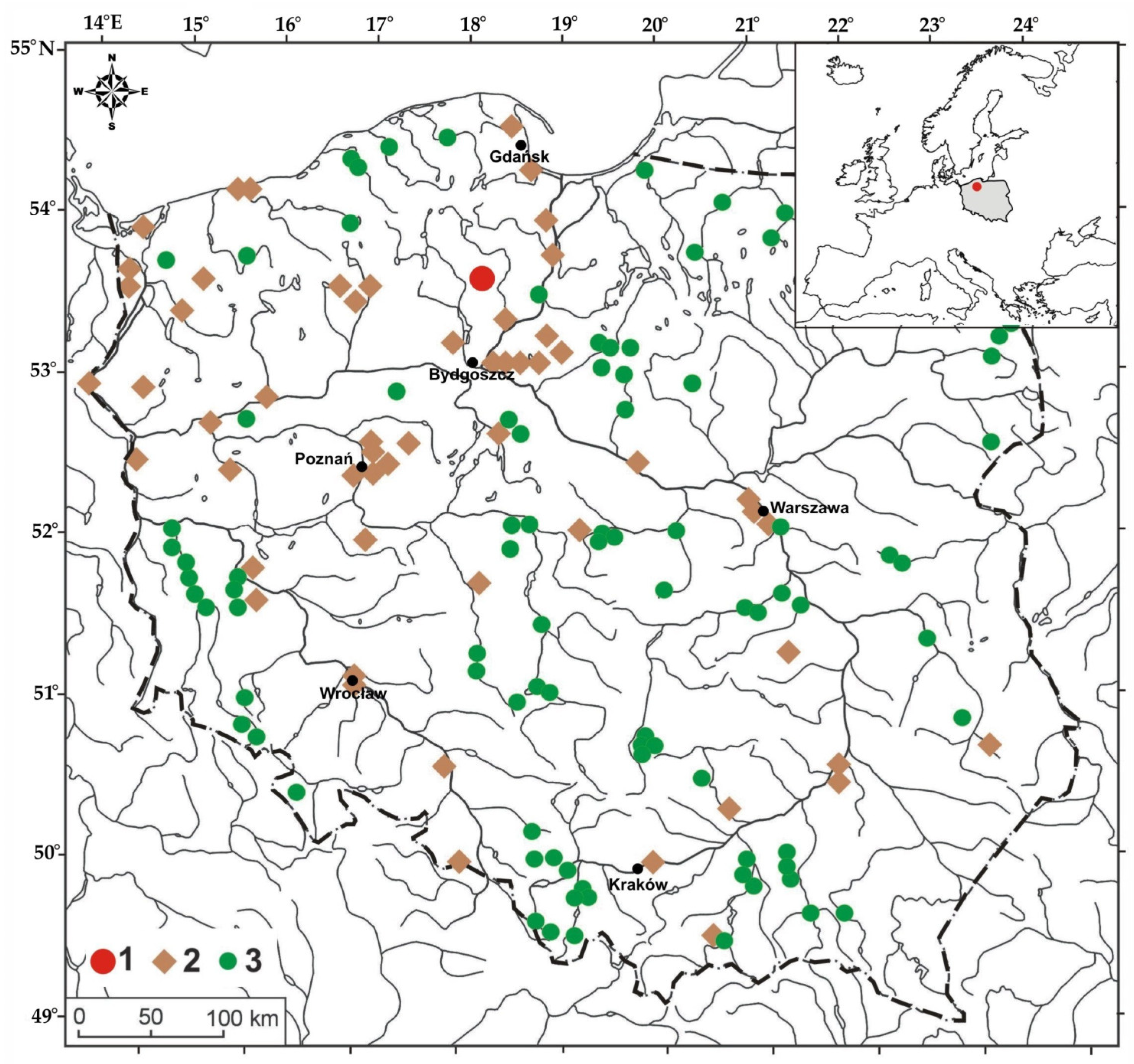
Documentation of the presence of beavers in the Middle Ages in the territory of Poland. 1—medieval beaver pond sediments documenting site, 2—medieval archaeological sites where beaver bone remains were discovered, 3—village names deriving from “beaver” (the geographical coordinates of the villages are given in Table S1 in the Supplementary Materials).
Figure 1.
Documentation of the presence of beavers in the Middle Ages in the territory of Poland. 1—medieval beaver pond sediments documenting site, 2—medieval archaeological sites where beaver bone remains were discovered, 3—village names deriving from “beaver” (the geographical coordinates of the villages are given in Table S1 in the Supplementary Materials).

Figure 2.
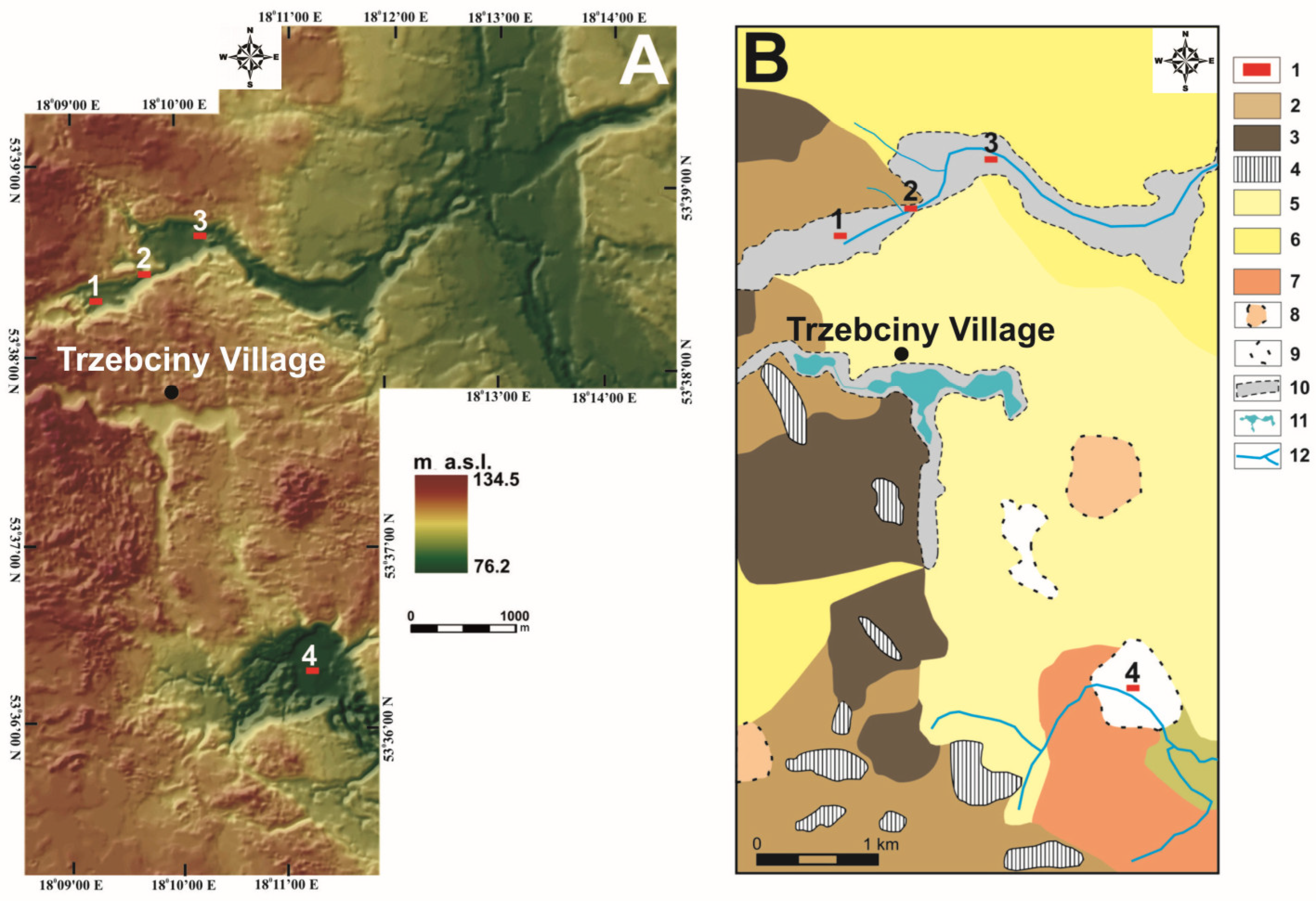
Location of the areas of study of relict beaver ponds dating back to the Middle Ages in the Gołyjonka valley. Places marked with numbers 1, 2, 3 (Goły Jon stream) and 4 (Zdrojanka river valley) indicate the location of 47 drillings. Point 4 in both figures indicates the location of the cores described in the text but located in the Zdrojanka valley (cores: ZDW1 and ZDW2). Source: own study based on topographic maps in the scale of 1:10,000 in the ArcGis 9 programme (ESRI, Redlands, CA, USA). (A)—surface topography of the test sites: 1—Goły Jon stream; 2—Gajdówka river valley; 3—Zdrojanka river valley. (B)—a geomorphological outline of a section of an outwash plain in the Tuchola Forest. 1—test sites; 2—flat moraine plateau; 3—undulated moraine plateau; 4—moraine hills; 5—older outwash plain (Poznań phase); 6—upper level of the more recent outwash plain (Pomeranian phase); 7—lower level of the more recent outwash plain; 8—aeolian sand fields; 9—dead-ice potholes; 10—meltwater valleys; 11—lakes; 12—rivers.
Figure 2.
Location of the areas of study of relict beaver ponds dating back to the Middle Ages in the Gołyjonka valley. Places marked with numbers 1, 2, 3 (Goły Jon stream) and 4 (Zdrojanka river valley) indicate the location of 47 drillings. Point 4 in both figures indicates the location of the cores described in the text but located in the Zdrojanka valley (cores: ZDW1 and ZDW2). Source: own study based on topographic maps in the scale of 1:10,000 in the ArcGis 9 programme (ESRI, Redlands, CA, USA). (A)—surface topography of the test sites: 1—Goły Jon stream; 2—Gajdówka river valley; 3—Zdrojanka river valley. (B)—a geomorphological outline of a section of an outwash plain in the Tuchola Forest. 1—test sites; 2—flat moraine plateau; 3—undulated moraine plateau; 4—moraine hills; 5—older outwash plain (Poznań phase); 6—upper level of the more recent outwash plain (Pomeranian phase); 7—lower level of the more recent outwash plain; 8—aeolian sand fields; 9—dead-ice potholes; 10—meltwater valleys; 11—lakes; 12—rivers.

Figure 3.
The Gołyjonka valley relief showing the location of 45 boreholes. Yellow dots mark the locations of Instorf probe testing. Red dots stand for cores GJ3, P1R1 and P1R3. Source: own study based on Airborne Laser Scanning (ALS) data, described as LIDAR (Light Detection and Ranging), made available by Geoportal 2 (www.geoportal.gov.pl, accessed on 12 November 2020).

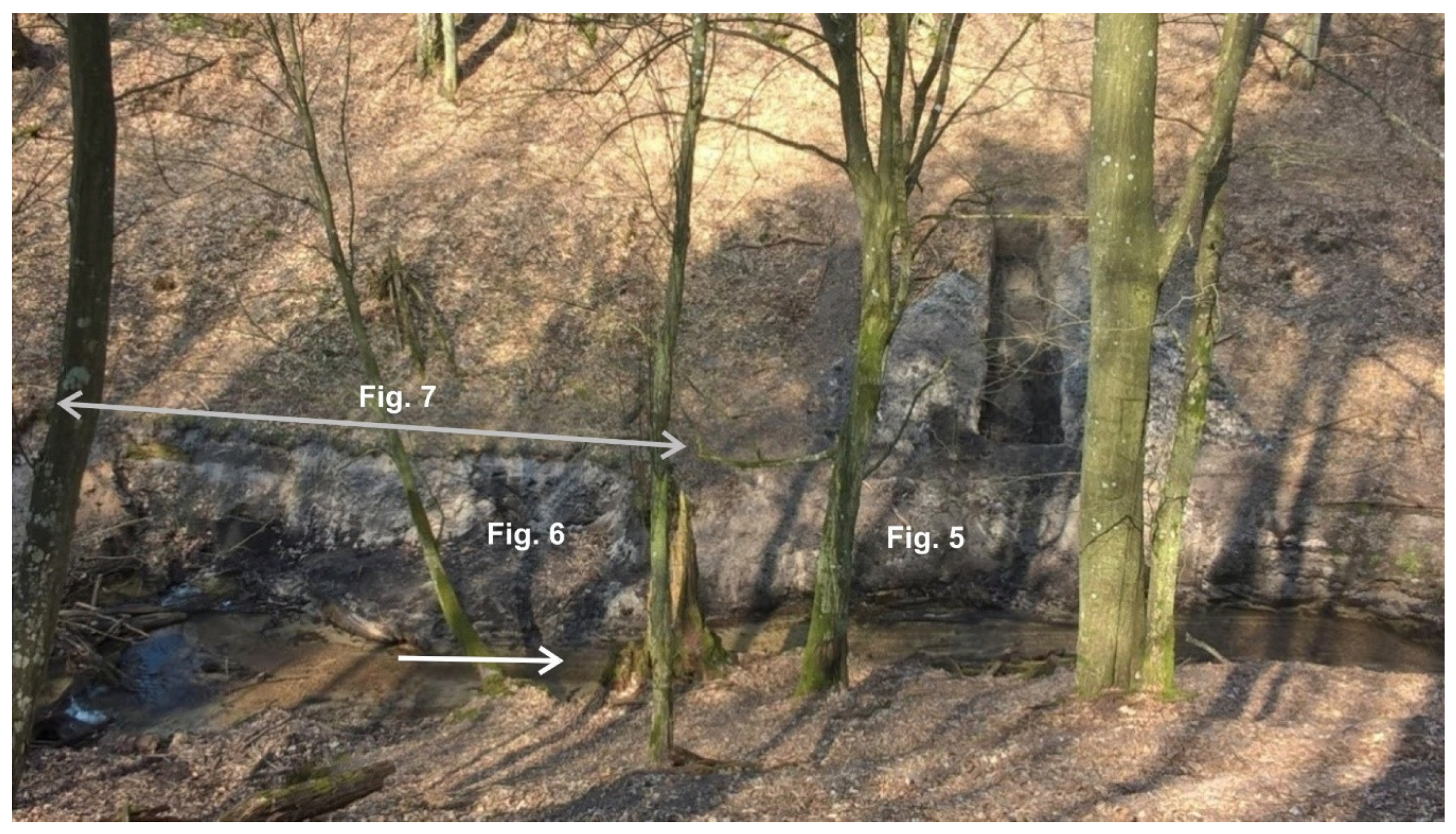
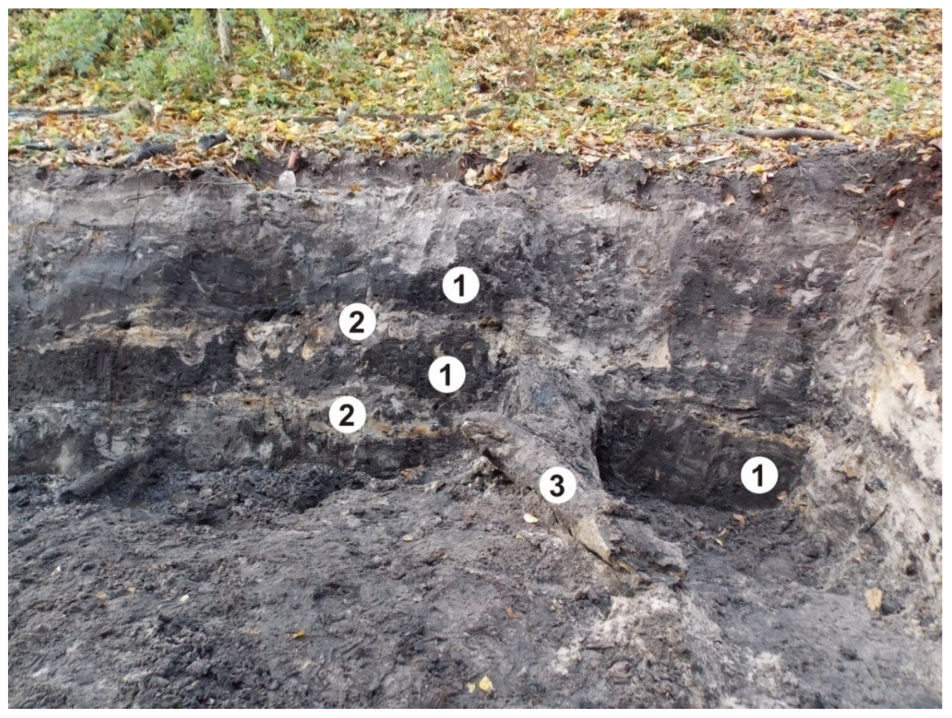
Figure 4.
A view of the exposed relict beaver ponds in 2017. The Figure shows the location of details presented in Figure 5, Figure 6 and Figure 7. The white arrow shows the water flow direction.

Figure 5.
Remnants of a beaver dam. A view from the top (upper part) and from the exposure (lower part). The exact location is shown in Figure 4.
Figure 5.
Remnants of a beaver dam. A view from the top (upper part) and from the exposure (lower part). The exact location is shown in Figure 4.

Figure 6.
Mineral–organic aggradate muds in the fill of relict beaver ponds dating back to the Middle Ages (1), separated by riverbed sands deposited during periods of free flow of water in the watercourse (2) and a “felled tree” (3). Wood detritus visible in deposits. The exact location is shown in Figure 4.

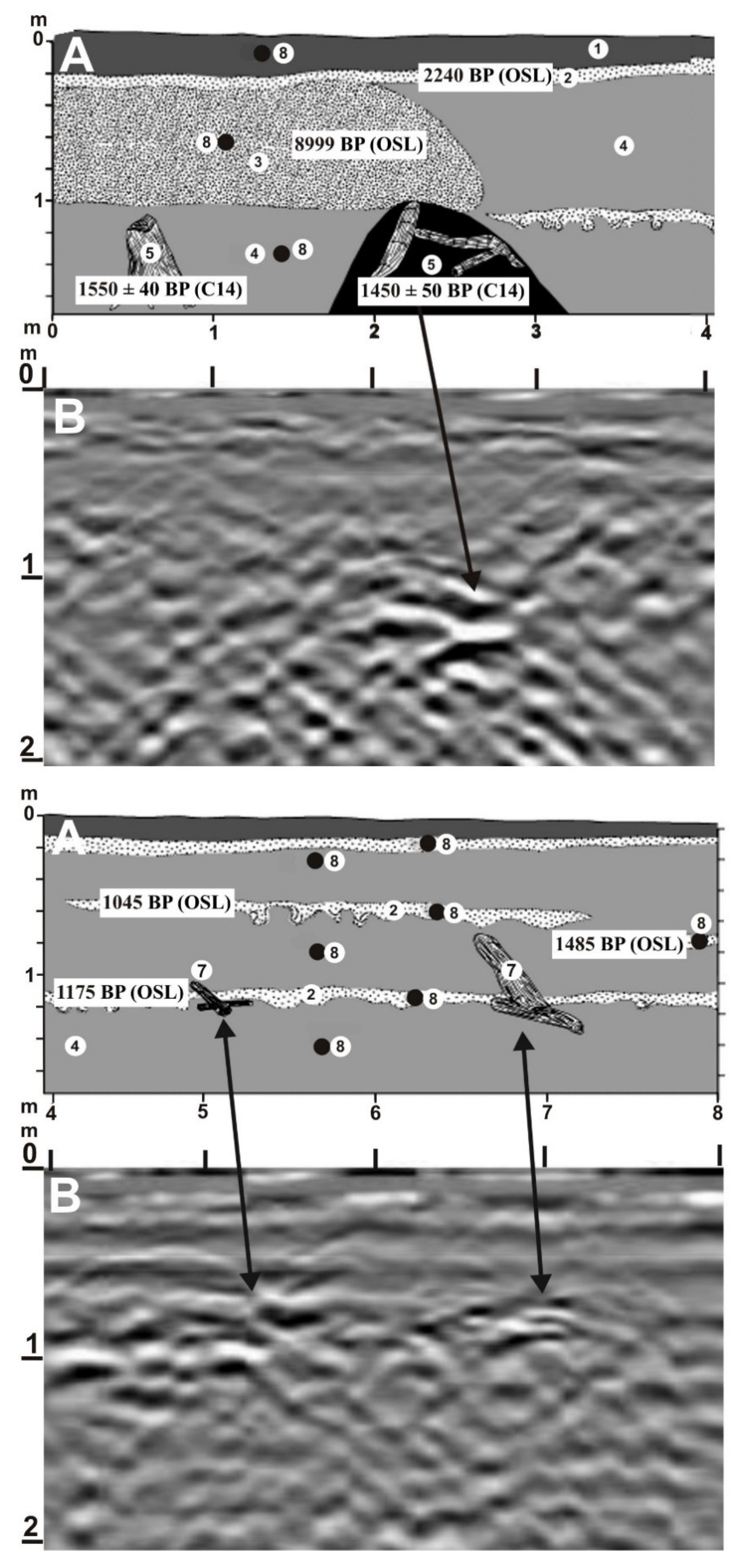
Figure 7.
Cross-section of an exposure recording the medieval stage of settlement of beavers in the Gołyjonka valley. (A)—exposures in the Goły Jon Gorge, (B)—GPR image. Description of the deposits: (1) topsoil (A) horizon on the most recent riverbed sands (organic C content —1.72%). (2) Layered sands, in places strongly deformed by load cast (organic C content 0.47%). Riverbed sands accumulated during periods of disappearance (probably due to the destruction of beaver dams) of still bodies of water (3) Massive sands interbedded with loam in the floor, eroded in the roof sequence (organic C content 1.03%). Fragment of the landslide debris tongue. Colluvial nature of the sands confirmed by OSL testing. (4) Massive mineral–organic dark-grey silt with numerous chunks of wood, including some with beaver teeth marks. Beaver pond sediments (organic C content 4.72%–13.4%). (5) Trunk of an alder tree still rooted in the bottom of a fossil beaver pond. (6) Accumulation of wood and mineral–organic silt into a mound perpendicular to the axis of the valley. Larger chunks of wood laying perpendicular to the valley axis, others arranged randomly. Relict beaver dam. (7) Larger chunks of wood in mineral–organic deposits (smaller wood detritus not indicated in the Figure). (8) Location of sampling for tests (loss on ignition) and OSL dating. The exact location is shown in Figure 4.

Figure 8.
Cores with alternating sand on peat and peat on sand deposits. Location cores—point 3 in Figure 2.
Figure 8.
Cores with alternating sand on peat and peat on sand deposits. Location cores—point 3 in Figure 2.

Figure 9.
Structure of the peat cover in wider sections of the Gołyjonka valley and the Zdrojanka valley. Examples of cores prepared during field surveys. 1—non-decomposed peat; 2—decomposed peat; 3—sand; 4—gyttja; 5—wood in mineral and organic deposits. Non-decomposed organic deposits are represented by different types of peat with wood detritus (moss peat, Sphagnum peat, sedge peat). Decomposed peat organic sediments with different degree of decomposition of the organic matter and with a share of amorphous matter exceeding 50% (black coloured).

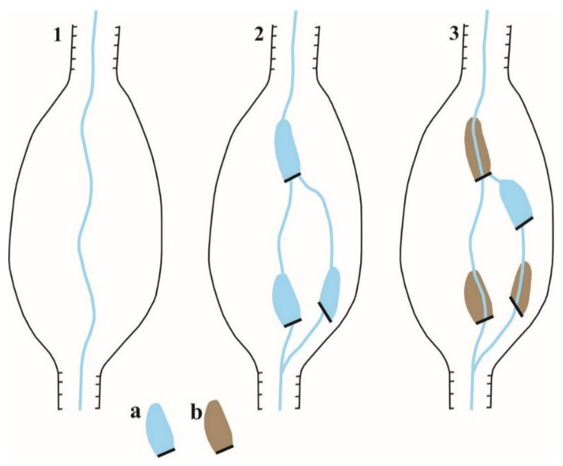
Figure 10.
The scheme of modification of the river network as a result of beaver ponds appearing in the valley: (a) ponds filled with water, (b) ponds filled with sediments and adjoining peat. 1. Bottom with a stream prior to colonisation by beavers. 2. Bottom with active ponds and avulsion of the river. 3. Bottom with overgrown ponds and an active pond.

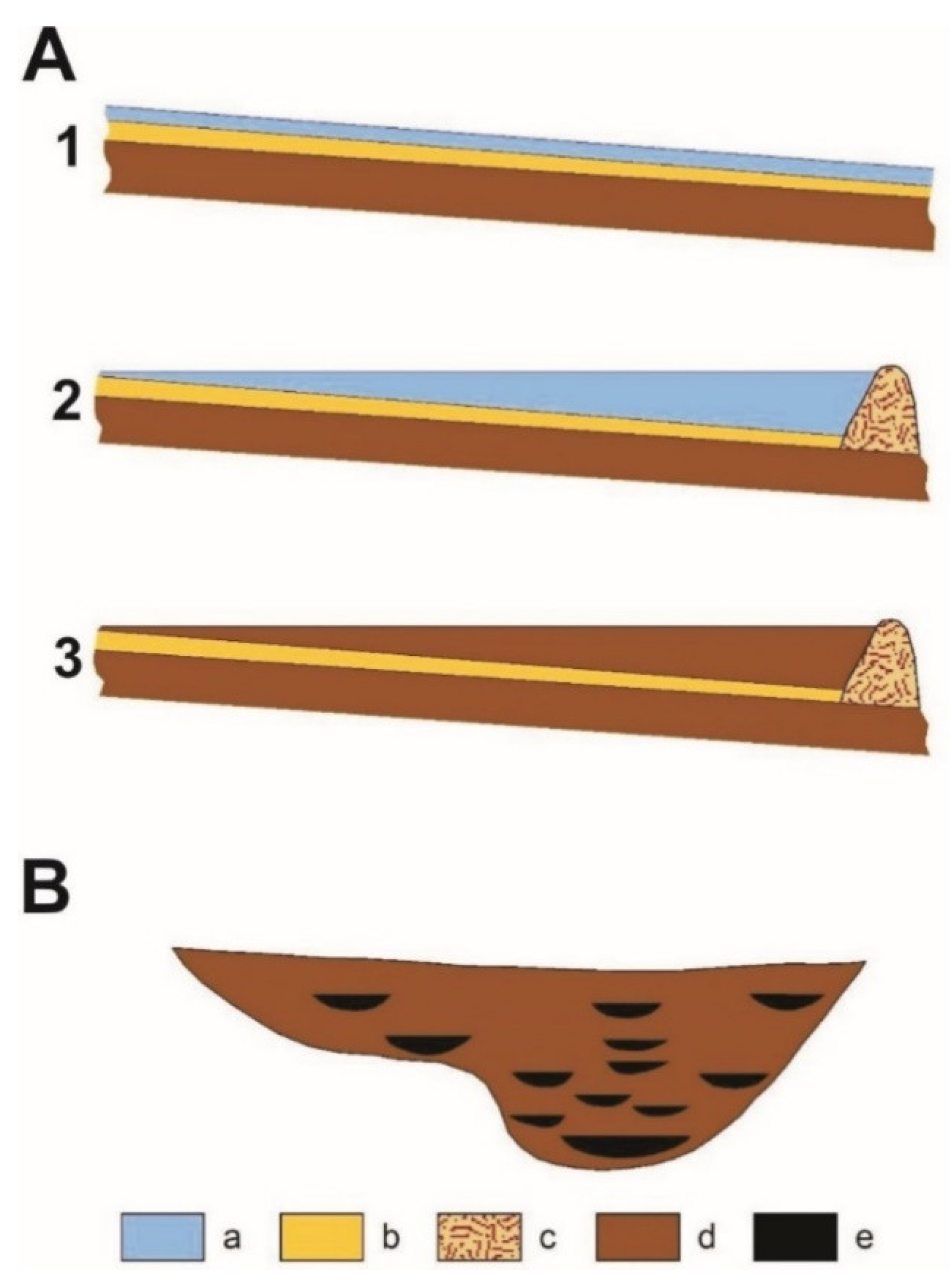
Figure 11.
The scheme of formation of sand–peat sequences in the bottom of the valley. (A)—formation and overgrowth of a beaver pond. 1 - watercourse without dam, 2 - beaver dam on the watercourse, 3 - filling the beaver pond with sediments. (B)—schematic transverse section of the valley with beaver pond sequences. a—water in the stream, pond; b—stream bed sand; c—beaver dam; d—mineral–organic sediments and peat; e—sediments filling beaver ponds.


Table 1.
Medieval age of samples collected for radiocarbon dating in the Gołyjonka valley.
| Valley | Geographical Coordinates of Samples | Laboratory Code of the Sample | Radiocarbon Date | Calibrated Date | Material and Sampling Place | Depth of Deposition in Metres |
|---|---|---|---|---|---|---|
| Goły Jon—suspended valley | 53°38′14.70″ N 18°09′03.22″ E | GdS-1238 | 1265 ± 40 BP | 663–779 cal AD | Wood from sediments | 0.4 |
| Goły Jon—suspended valley | 53°38′14.70″ N 18°09′03.22″ E | GdS-1267 | 1435 ± 45 BP | 556–664 cal AD | Peat | 0.6 |
| Goły Jon—gorge | 53°38′32.02″ N 18°09′46.77″ E | MKL-… | 1110 ± BP | 945–989 cal AD | Wood from sediments | 1.1 |
| Goły Jon—gorge | 53°38′32.27″ N 18°09′48.10″ E | Lic. no. MKL-2618 | 1450 ± 50 BP | 537–668 cal AD | Wood from relict beaver dam | 1.4 |
| Goły Jon—gorge | 53°38′32.27″ N 18°09′48.36″ E | Lic. no. MKL-2619 | 1550 ± 40 BP | 426–596 cal AD | Wood—tree trunk from sediments | 1.4 |
| Goły Jon—gorge | 53°38′32.60″ N 18°09′49.58″ E | Lic. no. MKL-3316 | 1290 ± 35 BP | 657–777 cal AD | Wood from sediments | 1.1 |
| Goły Jon—gorge | 53°38′32.60″ N 18°09′49.58″ E | Lic. no. MKL-3317 | 620 ± 60 BP | 1280–1419 cal AD | Wood from relict dam in another location | 0.6 |
| Goły Jon—wider section 2 | 53°38′44.78″ N 18°10′14.30″ E | GdS-3786 | 640 ± 70 BP | 1266–1425 cal AD | Wood from peat | 0.6 |
| Goły Jon—wider section 2 | 53°38′44.78″ N 18°10′14.30″ E | GdS-3784 | 765 ± 65 BP | 1156–1322 cal AD | Wood from peat | 0.8 |
| Goły Jon—wider section 2 | 53°38′44.86″ N 18°10′14.94″ E | GdS-3795 | 1460 ± 70 BP | 428–674 cal AD | Wood from peat | 1.1 |
Publisher’s Note: MDPI stays neutral with regard to jurisdictional claims in published maps and institutional affiliations. |
© 2021 by the authors. Licensee MDPI, Basel, Switzerland. This article is an open access article distributed under the terms and conditions of the Creative Commons Attribution (CC BY) license (http://creativecommons.org/licenses/by/4.0/).
Share and Cite
MDPI and ACS Style
Śnieszko, Z.; Rurek, M.; Hojan, M. Medieval Relict Beaver Ponds in the Polish Plain: Studies from the Tuchola Forest. Water 2021, 13, 777. https://doi.org/10.3390/w13060777
AMA Style
Śnieszko Z, Rurek M, Hojan M. Medieval Relict Beaver Ponds in the Polish Plain: Studies from the Tuchola Forest. Water. 2021; 13(6):777. https://doi.org/10.3390/w13060777
Chicago/Turabian StyleŚnieszko, Zbigniew, Mirosław Rurek, and Marcin Hojan. 2021. "Medieval Relict Beaver Ponds in the Polish Plain: Studies from the Tuchola Forest" Water 13, no. 6: 777. https://doi.org/10.3390/w13060777
Note that from the first issue of 2016, this journal uses article numbers instead of page numbers. See further details here.