
The Prospects of Evolution of the Baseline Systems in the Arctic


1
National Research University Higher School of Economics, 101000 Moscow, Russia
2
Law firm LTD PKF Factor, 119192 Moscow, Russia
3
Independent Researcher, Sadovaya-Kudrinskaya Street, 28-30, apt. 33, 123001 Moscow, Russia
*
Author to whom correspondence should be addressed.
Water 2021, 13(8), 1082; https://doi.org/10.3390/w13081082
Submission received: 11 February 2021
/
Revised: 28 March 2021
/
Accepted: 31 March 2021
/
Published: 14 April 2021
(This article belongs to the Section Water Resources Management, Policy and Governance)
Abstract
:The article discusses the notion of “baselines” and the legal framework for drawing them, as well as the practice of drawing baselines, primarily by the coastal Arctic states. As a result of analysis, we make a suggestion that the existing system of baselines in the Arctic Ocean seas may evolve on the basis of international legal rules, with due account taken of the practice of applying them, and through the use of such a legal concept as “historic waters.” The article covers the interpretation of the concept of “historic waters” in various sources, indicating how this concept is used by different states to proclaim their rights to adjacent maritime areas on historical grounds. We have drawn on our extensive research and documents identified that may be used by the Russian Federation to expand its “historic waters” on the Arctic coast. At the same time, we have not aimed at making specific proposals on changing the location of the existing baselines or declaring new Arctic water areas “historic waters.” Rather, our objective was to comprehensively study the possibility of preparing such proposals.
1. Introduction
Baselines are one of the essential notions of the international law of the sea. These are the lines used to measure the width of the territorial sea that falls under the coastal state’s sovereignty. The outer boundary of the territorial sea is the coastal state’s maritime boundary. These are also the lines used to measure the width of the exclusive economic zone and continental shelf where the coastal state enjoys broad sovereign rights or jurisdiction. For this reason, the issue of the optimal location of the baselines is crucial for safeguarding the sovereignty, sovereign rights and national security of any coastal state.
By now, a certain system of baselines drawn by the coastal Arctic states has been established in the Arctic Ocean. Its formation took more than one decade. Is it final or are there preconditions for its further evolution? We have set out our understanding of the answer to this question below.
2. Legal Framework for Baselines
One of the key (albeit not the only) international legal instruments governing all types of activities in the seas and oceans is the 1982 UN Convention on the Law of the Sea (the UNCLOS). The UNCLOS does not distinguish the Arctic Ocean in any way, although it significantly differs from all the other oceans. First, for most of the year (or even year-round), it is covered with ice, which greatly hinders navigation and other modes of its economic exploitation. Second, another undeniable peculiarity of the Arctic Ocean is that it is essentially a semi-closed space, as it is closed by the territorial seas of Russia and the U.S. in the east, and by the exclusive economic zones (EEZs) of Norway and Denmark (Greenland) in the west. (Notably, a “semi-closed space” is not a conventional term of art; we are using it here to emphasize one of the important characteristics of the Arctic Ocean only.) Despite these peculiarities, the coastal Arctic states only enjoy the right to take additional measures to fight pollution within their EEZs (UNCLOS, Article 234).
Importantly, as one of the five coastal Arctic states (Russia, Canada, Norway, Denmark and the USA), the USA is not a party to the UNCLOS. This fact, among other things, caused the foreign ministers of these states to recognize, in their declaration adopted at the Arctic Ocean Conference (Ilulissat, Greenland, 27–29 May 2008), that “an extensive international legal framework applies to the Arctic Ocean,” which “provides a solid foundation for responsible management by the five coastal States and other users of this Ocean through national implementation and application of relevant provisions.” [1].
As regards setting baselines, this “extensive international legal framework” may, in our opinion, also include other relevant international legal acts and sources, apart from the UNCLOS (the 1958 Geneva Convention on the Territorial Sea and Contiguous Zone; the judgments of the International Court of Justice, including in the 1951 Fisheries Case (United Kingdom v. Norway). “The Judgment delivered by the Court in this case ended a long controversy between the United Kingdom and Norway which had aroused considerable interest in other maritime States” [2]; the International Law Commission (ILC) Commentary, etc.), treaty and custom rules of international law.
Under the UNCLOS, the term “baseline” comprises two types of baselines: normal and straight baselines.
UNCLOS Article 5 provides that “the normal baseline for measuring the breadth of the territorial sea is the low-water line along the coast as marked on large-scale charts officially recognized by the coastal State.”
It follows from this definition that to establish the normal baselines and mark them on large-scale charts, in case of a long coastline, one needs to carry out an extreme scope of hydrographic and cartographic works related to making or correcting a great many large-scale maps, as well as updating them regularly in view of the natural processes affecting the coastline topography.
Under UNCLOS Article 7, “in localities where the coastline is deeply indented and cut into, or if there is a fringe of islands along the coast in its immediate vicinity, the method of straight baselines joining appropriate points may be employed. […] The drawing of straight baselines must not depart to any appreciable extent from the general direction of the coast, and the sea areas lying within the lines must be sufficiently closely linked to the land domain to be subject to the regime of internal waters.” Under the same UNCLOS Article, straight baselines may also be employed in places where the coastline is highly unstable, such as in river deltas, and, where the method of straight baselines is used, “account may be taken […] of economic interests peculiar to the region concerned, the reality and the importance of which are clearly evidenced by long usage.”
The UNCLOS also allows coastal states to combine normal and straight baselines.
The provisions of UNCLOS Article 7 cited above contain many uncertainties: “deeply indented and cut into,” “immediate vicinity,” “depart to any appreciable extent,” “sufficiently closely linked,” etc. No mathematically accurate definitions of these UNCLOS terms are to be found in either customary or treaty rules of the applicable international law. Hence, these terms may receive different interpretations.
The permissible length of straight baselines for coastal states other than archipelago states is not envisaged in the UNCLOS, except where such lines close the entrance to bays. In that case, UNCLOS Article 10 requires such lines not to exceed 24 nautical miles. Even that limitation, however, does not apply to straight baselines closing the bays that enjoy the status of “historic bays.” Archipelago states are allowed to draw straight baselines of up to 100 nautical miles, where 3% of the total straight baselines may be up to 125 nautical miles.
In 1989, with the financial support of the Government of Japan, the Division for Ocean Affairs and the Law of the Sea of the Office of Legal Affairs within the UN Secretariat made an attempt to address the uncertainties related to straight baselines and to specify the above Convention terms. That attempt did not result in the issuance of the relevant legal recommendations; however, the Division prepared a document entitled “The Law of the Sea. Baselines: An Examination of the Relevant Provisions of the United Nations Convention on the Law of the Sea” [3]. This document is not legally binding but contains certain technical guidelines.
The introduction to the above document, signed by the UN Under-Secretary-General and Special Representative of the Secretary-General for the Law of the Sea, calls it a “manuscript” that “examines all the provisions of the articles in the Convention dealing with baselines and attempts to give guidance on their application without prejudging controversial matters of law” [3]. It is further noted that these guidelines are not exhaustive, since “there exists too great a variety of geographical situations to anticipate and address every problem” [3]. At the same time, the Under-Secretary-General expresses the hope that “this study will… be of assistance to a wide variety of users” [3]. The document confirms that “the legislative procedures for giving effect to the baselines will be based on the constitutional and administrative requirements of each state” [3], that is, on the national (domestic) law of the respective coastal state, along whose coastline the baselines are drawn.
Against the backdrop of these commentaries, we will now examine certain provisions of this manuscript on straight baselines. It gives an example where normal baselines and the lines closing bays and river deltas form a complex topography of the boundaries of the territorial sea. For that case, the manuscript advises employing straight baselines, as a way to simplify such a configuration. It further notes that there are no objective, universally recognized criteria allowing one to define the notion of a “deeply indented coast,” nor are there any criteria for defining the meaning of the term “a fringe of islands along the coast.” The only clear thing is that there should be more than one island in a fringe and it should not be arranged perpendicularly to the coast.
The manuscript entertains two possible situations applicable to the arrangement of a fringe of islands: first, where the islands appear to form a unity with the mainland and appear to be a continuation of the mainland on small-scale maps; and, second, when islands are some distance from the coast, forming a screen which masks a large proportion of the coast from the sea.
The phrase “immediate vicinity” of the fringe of islands, too, has no absolute test. In this regard, the manuscript sets out the following reasoning: “It is generally agreed that with a 12-mile territorial sea, a distance of 24 miles would satisfy the conditions. The distance that has been proposed in the literature as a general rule is 48 miles for islands”, “which could be exceeded in certain circumstances, but this figure is not necessarily agreed upon.”
Here, one must pay special attention to the ICJ judgments in maritime boundary cases. They underscore the importance of the length of the coastline of the coastal state. Thus, when interpreting the applicable rules of the international law in 1982, the ICJ confirmed that it is the “the coast of the territory of the State [that] is the decisive factor for title” to the adjacent maritime areas [4].
The length and configuration of the mainland coast of the Arctic states are vastly different.
3. International Practice of Drawing Baselines
USA. From among the five coastal Arctic states, only the USA practices the approach, according to which the baselines should follow the low-water line. The USA only draws closing straight lines in case of bays, whose geographical characteristics meet the legal test found in Articles (1)–(5) of the 1958 Geneva Convention on the Territorial Sea and Contiguous Zone, which the U.S. is a party of. Similar criteria can be found in Articles (1)–(5) of the UNCLOS.
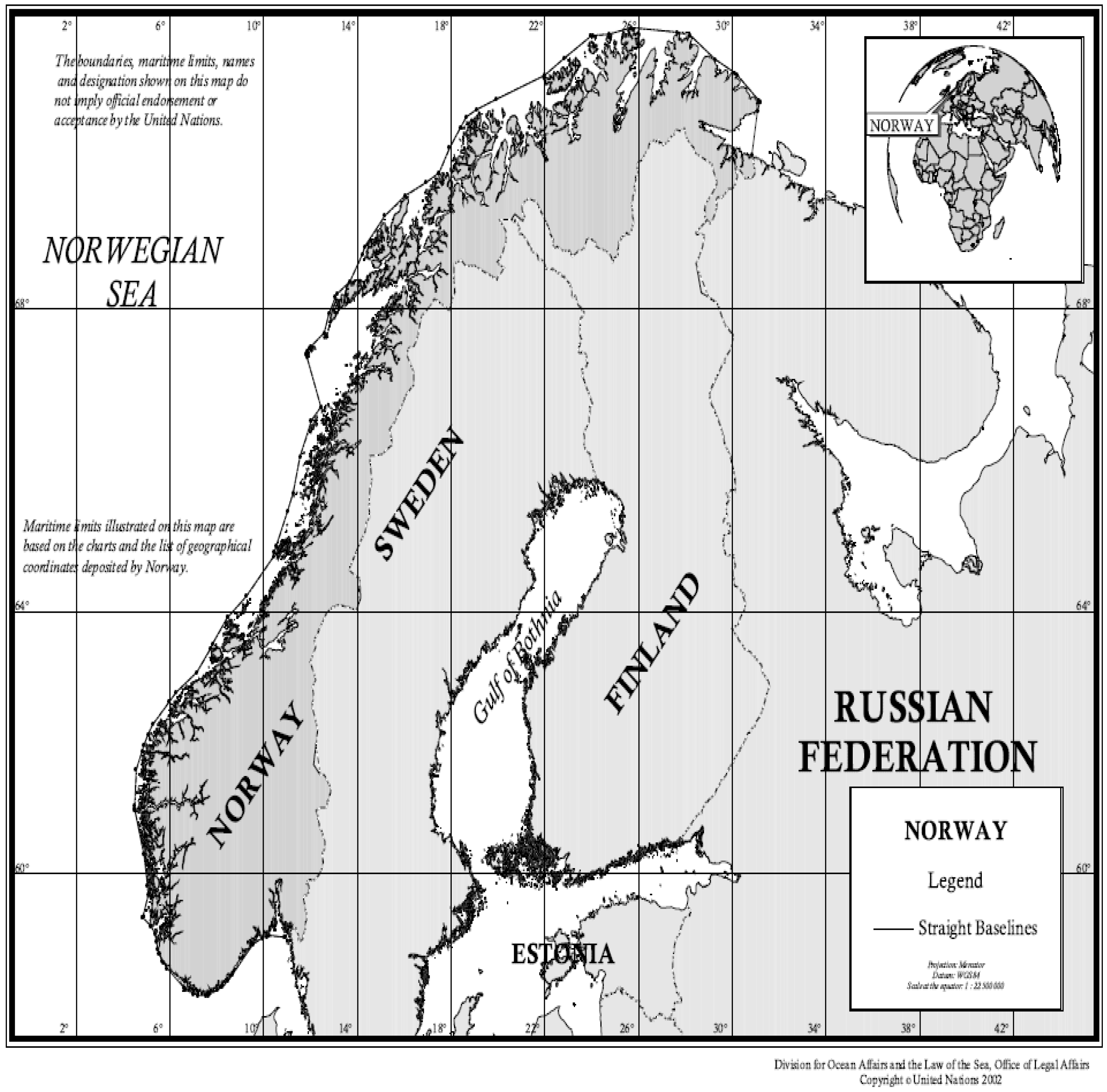
Norway has established straight baselines along its entire mainland coast, and some of them are more than 40 nautical miles long (Figure 1).
Importantly, Norway has not only revised the coordinates of the end points of such baselines on multiple occasions but also changed their configuration so as to materially increase its own state maritime territory.
We should recall that the 1935 “Royal Decree of 12 July 1935, relating to the Baselines for the Norwegian Fishery Zone as regards that part of Norway which is situated to the north of 66°28′8 N Latitude” [5] was the first national law on straight baselines in the world. The 1951 ICJ Judgment (Fisheries (United Kingdom v. Norway). Judgment of 18 December 1951) [6] affecting substantial economic interests not only of Norway and the UK as the litigating states but also of other countries has had a determinative impact on the subsequent development of international law and its codification in this sphere.
In its current legal policy, Norway efficiently relies on the 1951 ICJ Judgment issued in its dispute with the UK to justify the legality of its straight baselines in its relations with foreign states.
Norway has also drawn straight baselines along its Jan Mayen island that is relatively distant from its mainland coast. Although the Jan Mayen island is not characterized by significant indentures in its coastline or by a fringe of islands in its vicinity, Norway issued the Royal Decree of 30 June 1955 [6], drawing straight baselines along the furthest seaward points of that island’s shores.
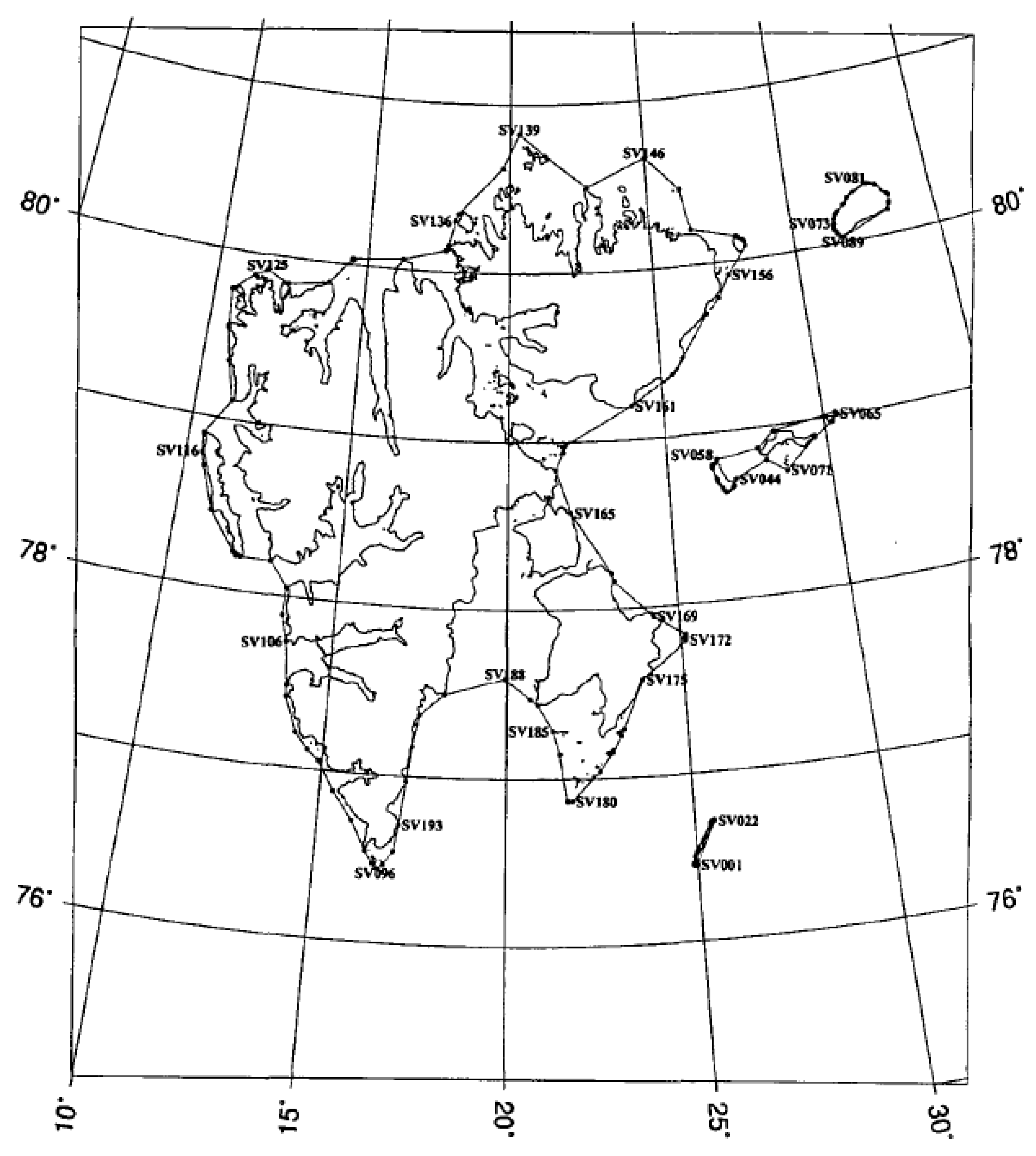
Norway acted with even greater political ambition and legal resourcefulness when it established straight baselines along the islands of the Spitsbergen archipelago (Figure 2).
While Spitsbergen is part of Norway’s state territory, it enjoys a special status by virtue of the 1920 Spitsbergen Treaty, which grants considerable rights to other states on these islands. Norway, however, drew straight baselines around Spitsbergen under the Royal Decree of 25 September 1970 [7] without any consultations with the other state parties to the Treaty. Norway measured the width of the “territorial waters of the localities” of Spitsbergen from the coordinates and the resulting straight baselines set forth in the Royal Decree.
It should be noted that the 1920 Treaty does not refer to Norway’s internal waters or territorial sea around Spitsbergen; rather, the Treaty provides for a new maritime territory, the territorial waters of Spitsbergen, where the nationals of Norway and other contracting states have equal rights.
On 1 June 2001, Norway issued regulations relating to the limits of the Norwegian territorial sea around Svalbard (Royal Decree of I June 2001) [8] that establish new straight baselines around the Spitsbergen archipelago, different from the ones that had been introduced by the 1970 Royal Decree.
Thus, under the Norwegian laws, the Governor of Spitsbergen may prohibit passage of vessels in the waters of the localities of Spitsbergen, if such waters qualify as a national park [9]. The new straight baselines mean, in this context, expanding the waters of the national park.
Denmark mainly uses straight baselines along the coast of Greenland (Figure 3).
Notably, about ¾ of Greenland’s sea coast is in the Arctic.
The main sources underlying Denmark’s legal position on this issue are the Royal Decree of 21 December 1966 on Delimitation of the Territorial Sea (as amended by Decree No. 189 of 19 April 1978), and the Executive Orders of 1976 and 1980 issued in furtherance thereof [10].
The segments legislatively marked along the coast of Greenland total 75 in the south and 82 in the north, practically fully covering the island; straight baselines are drawn along them. The longest straight baselines are up to 65.6, 67.2 and 66.4 nautical miles long (the English names for the relevant places are Disco Bay, Umanak Fjord, Kane Basin) on the western coast; and 67.2 and 80.1 nautical miles in the north, in the vicinity of the Princess Dagmar Peninsula.
Russia (like the majority of other states) has not protested against such straight baselines; that is, in this case, too, the international community acquiesced to Denmark’s establishing, as a coastal state, much longer straight baselines along the coast of Greenland than those unsuccessfully challenged by the UK before the ICJ in 1951.
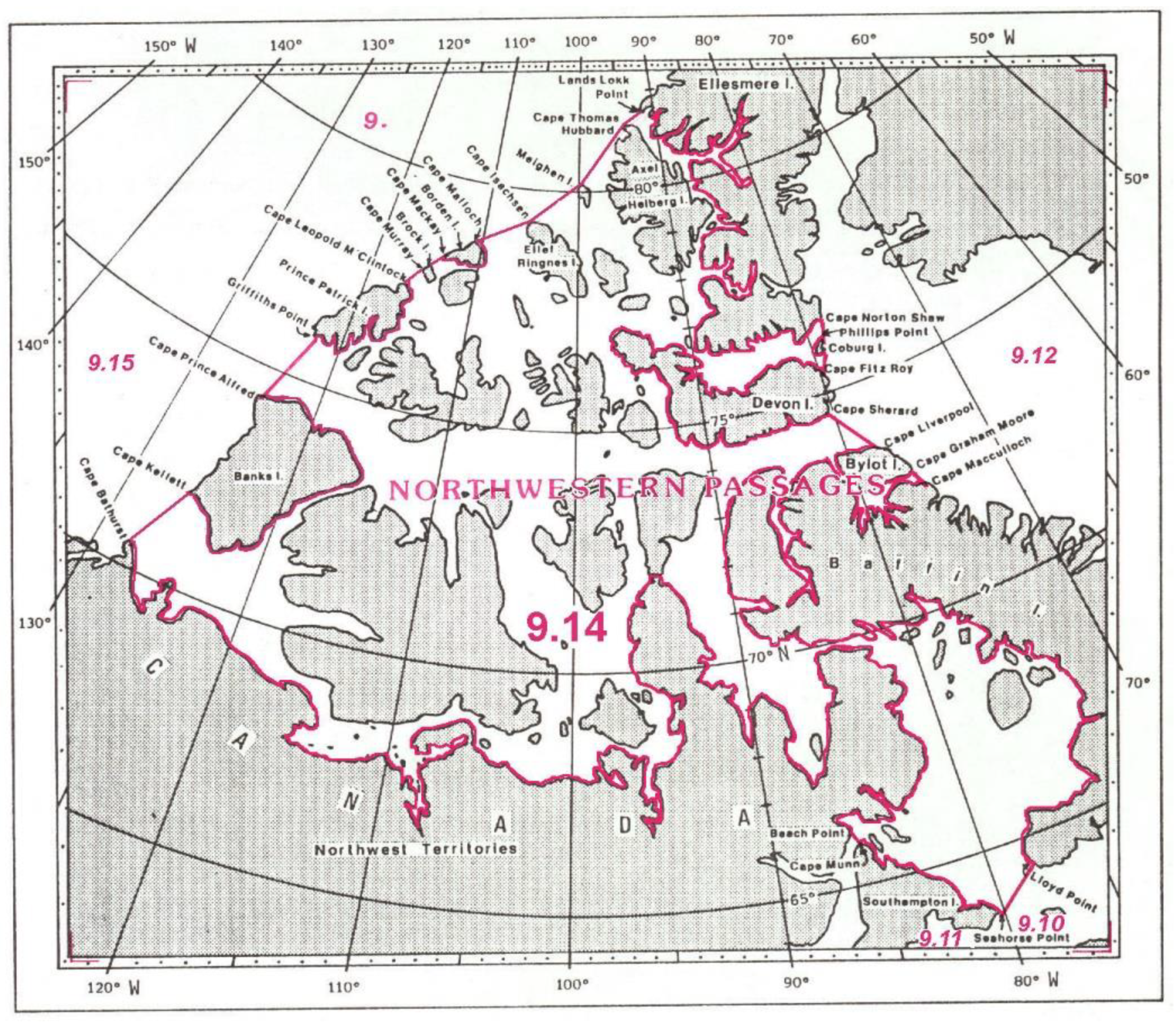
Canada established straight baselines along the perimeter of the Canadian Arctic Archipelago in line with the aforementioned Territorial Sea Geographical Co-ordinates Order of 10 September 1985 [11] (Figure 4).
The Order introduces the term “Area 7” that includes the Canadian Arctic Islands and Mainland, as well as all ice and water territories adjacent thereto. The coastline is divided into 139 segments. The longest straight baselines are up to 99.5 and 92.1 nautical miles long.
Notably, when ratifying the UNCLOS on 7 November 2003, Canada made an Article 310 declaration, reserving its discretion to decide which body will make a decision on the confirmation of Canada’s rights in the Arctic, and following which procedure. Canada also filed a declaration refusing the mandatory procedure for resolving certain disputes under the UNCLOS, with the UN Secretariat. These disputes could concern delimitation, especially when it relates to “historic” bays; the issues of military action; compulsory measures in the exercise of sovereign rights; and the issues involving the UN Security Council.
That Canada’s drawing of straight baselines in the Arctic is not contrary to the rules of international law has been demonstrated by an American international law scholar—contrary to the official position of the U.S. State Department [12]. Thus, the American scholar John Klotz confirmed the legality of Canada’s exercise of special jurisdiction in the “Canadian Arctic.” First, according to him, such special jurisdiction is, in many respects, lawful from the standpoint of the five universally recognized grounds for exercising national jurisdiction (the territorial principle; protection of national interests from threats to the defence of the state; exercising jurisdiction over the state’s own nationals irrespective of their location, or over aliens who have committed crimes against its nationals; protection of “universal” interests, combatting piracy, slavery, etc.) [13]. Second, he opines that exercising special jurisdiction against polluters—according to the existing international environmental law—also constitutes Canada’s duty.
Canada’s government repeatedly stressed that Canada’s extension of its domestic legislative regulation in the regions of its Arctic sector is due not only to its national interests but also the interests of the entire humankind, which will objectively benefit strategically from the preservation of the Arctic ecosystem and environment, especially given that there are no efficient international legal rules for achieving that aim. In his day, the former Canadian prime minister P. Trudeau made the following statement: “… where no law exists, or where law is clearly insufficient, there is no international common law applying to the Arctic seas; we’re saying somebody has to preserve this area for mankind until international law develops” [14].
It is particularly pertinent to note that Canada’s claims on straight baselines in the Arctic regions, where Canada asserts its historic title and defence interests, have never been examined by an international court or arbitral tribunal.
4. Baselines Along Russia’s Arctic Coast
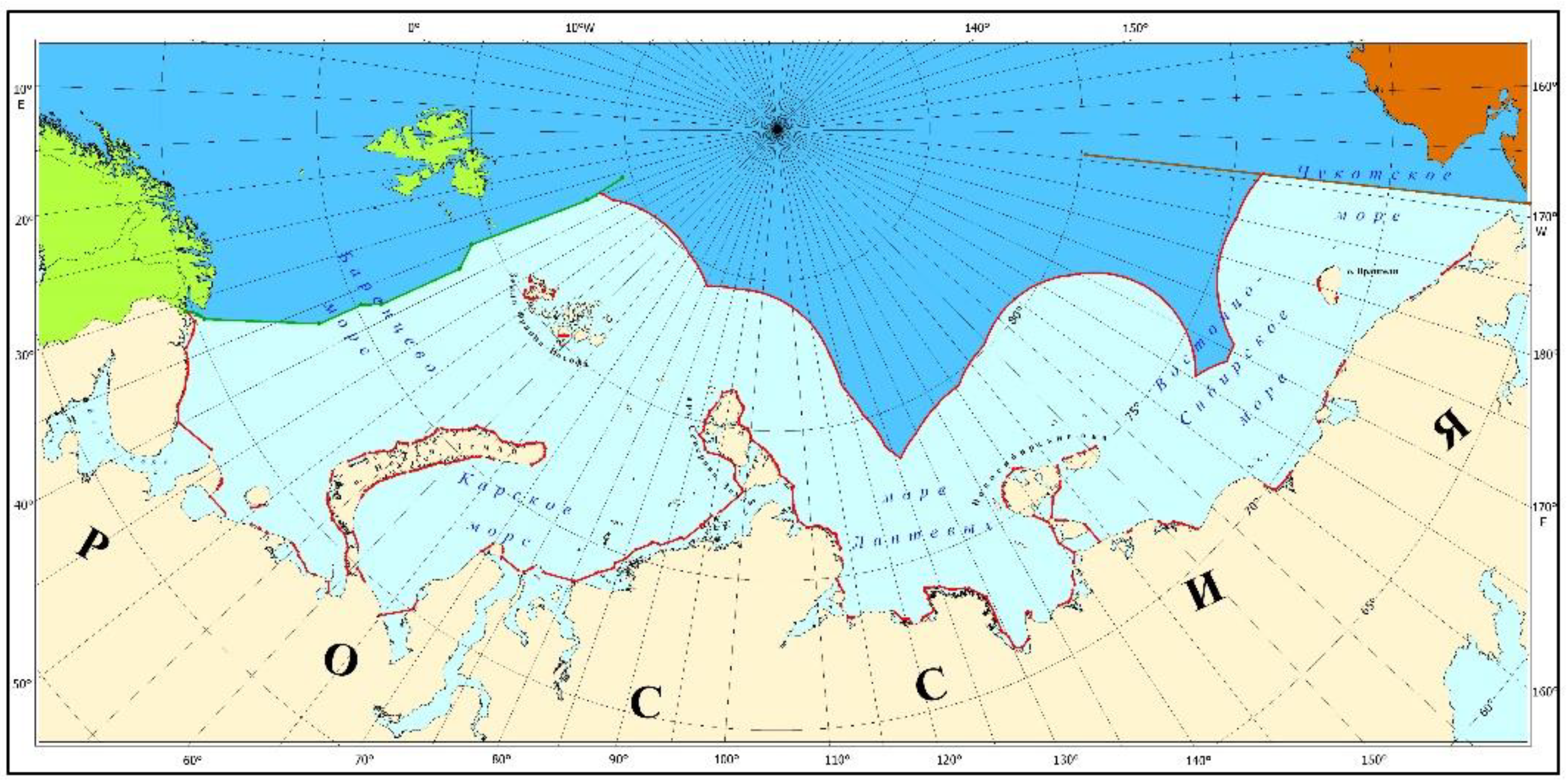
Russia’s effective baselines system has been set forth by the Resolution of the USSR Council of Ministers of 15 January 1985 that approved the “List of Geographical Co-ordinates of the Points Defining the Position of the Baselines for Measuring the Breadth of the Territorial Sea, the Exclusive Economic Zone and the Continental Shelf of the USSR” (the 1985 List) [15]. It uses a combination of straight and normal baselines (Figure 5). The 1985 List specifies the coordinates of the total of 431 reference points in the Arctic Ocean seas.
After the approval of the said 1985 List, there have been further developments. In 1994, the UNCLOS entered into full force and effect, and in 1997, it was ratified and became effective for Russia. In recent decades, a number of states have set new lists of straight baselines along their coasts, often based on contemporary interpretations of the applicable international legal rules, including a new reading of the legal propositions implied in the ICJ judgment of 1951.
It should also be considered that because of the reduction in the area of perennial ice in the Arctic Ocean due to abrasive and other natural processes resulting in the sea advancing to the shore in Russia’s Arctic seas, the configuration of the Russian coastline is undergoing substantial changes as compared to the 1985 situation.
A comparison of the currently available data on the changes of Russia’s coastline in the Arctic with the respective rules of the UNCLOS on baselines reviewed above shows that options are available regarding the future of the baselines along the Russian Arctic coasts. One of the options might be to preserve normal baselines along most of the Arctic coast, as is currently reflected in the Russian legislation. Another option might be to take into account the practice of other Arctic states, such as Canada, Denmark (Greenland) and Norway, and to draw only straight baselines along the Russian Arctic coast. Needless to say, a “median option”—between the first and the second—is also available. In case of the low-water lines, there will be a need to periodically revise positions of baselines due to the highly unstable coastline in the Russian Arctic and hence to conduct a new hydrographic survey to create or correct the required nautical charts. The advantage of the only straight baselines Arctic approach is the similarity to the legal policy of Canada, Denmark and Norway and the practical convenience potential: baselines are drawn between selected points, but they remain unchanged despite the subsequent changes of the “low-water line.”
In addition, for many islands in the Kara, Laptev and East Siberian Seas, no baselines were drawn at all.
That is why the Russian academia has, for a long time, raised concerns regarding the need to revise the 1985 List [16]. This shows that a great number of experts believe that the need to revise the 1985 List is evident. The international law does not limit the coastal state’s right to change the position of its previously approved baselines. Moreover, this right has been exercised by many states, including the Arctic states, namely, Norway and Denmark.
The factors listed below serve as a ground for improving the revision of the baselines system in Russia’s Arctic seas.
1. Even a cursory look at the map of the Arctic Ocean makes it clear that the Arctic coast of the Russian Federation is considerably longer than that of other Arctic states and is estimated at 40 thousand kilometers, including the length of the mainland part of the coast of around 27 thousand kilometers [17]. This is very important, since the ICJ confirmed in 1982 that “the coast of the territory of the State is the decisive factor for title” to the adjacent maritime areas.
2. The coastline of Russia’s Arctic seas is inconstant, since a large portion of the coast is formed out of frozen rock, including subterranean ice. This coast structure facilitates the proliferation of abrasive processes. Abrasion is the most intense on the coast of the Barents Sea in the Nenets Autonomous District, in Franz Joseph Land, in the Kara Sea in the vicinity of the Yamal and Gyda Peninsulas and from the mouth of the Khatanga River in the Laptev Sea to the Chaunskaya Bay in the East Siberian Sea. Thus, for instance, in the Laptev Sea, abrasion may reach 30–55 m annually, which has caused three islands to disappear over the span of several decades [17]. Climate change is expected to massively accelerate abrasion.
3. The configuration of the coast of each of the Arctic states is very specific. Nonetheless, as paradoxical as it may seem, the Arctic coasts of Russia and Norway are in many ways similar. First, there are fringes of islands along a considerable portion of the Russian coast, similarly to the Norwegian coastline. Second, Norway has the Spitsbergen archipelago that is remote from the coast, while Russia, too, has several archipelago islands (Franz Joseph Land, Novaya Zemlya, Severnaya Zemlya, New Siberian Islands). Accordingly, Norway’s practice of drawing baselines is especially relevant for Russia.
4. In a number of cases, international legal rules allow drawing straight baselines instead of normal baselines.
5. Certain islands and island groups in the Kara, Laptev and East Siberian Seas have no established baselines.
6. As demonstrated above, the coastal areas of the Arctic zone of the Russian Federation and the adjacent offshore zones are closely connected economically. The industrial development of these areas and sustaining the life of the settlements located in such areas would be impossible without carriage of the necessary cargo through the adjacent zones, while the biological resources of such zones serve as the key source of sustenance for the indigenous peoples that constitute a rather large share of the local population. Here, the long usage of these areas clearly evidences the reality and importance of the economic interests peculiar to them, as provided in UNCLOS Article 7.
As regards the permissible length of new straight baselines, should the 1985 List be revised, the UNCLOS does not prescribe such a threshold (except for archipelago states). This can be illustrated by Denmark’s (Greenland’s) longest straight baseline of 80.1 nautical miles, and that of Canada of 95.5 nautical miles. One must keep in mind in this regard that the predominant legal approach in the international legal doctrine is that the practice of affected coastal states, the consent (including acquiescence) to this practice by other states and the belief that it is lawful form the relevant international custom that elaborates the general wording of the respective treaty rules. This characterizes the practice of states that draw straight baselines with a significant maximum length, including: 89 nautical miles (Mauritania, Decrees of 21 January 1967 and 3 August 1988); 120 nautical miles (Guinea, Law of 3 June 1964); 131 nautical miles (Colombia, Decree of 12 July 1984); 1618 nautical miles (Vietnam, Declaration on the Baseline of the Territorial Waters of 12 November 1982); 220 nautical miles (Burma (Myanmar), President’s Declaration of 15 November 1968), etc. Such practice of establishing straight baselines in special circumstances has met no opposition on the part of the majority of states.
5. Historic Waters
The notion of “historic waters”. As noted above, the 24-mile limitation for the closing line of a bay does not apply to historic bays (UNCLOS, Article 10(6)). Notably, the international practice (the ICJ judgments, the ILC materials, etc.) also uses a broader term, the “historic waters.” Historic bays (like the historic waters) are delimited by straight closing lines [18].
International treaty law contains no definition for the concepts of “historic bays” or “historic waters” and does not provide for grounds for states to make their claims to such waters. The UN attempts to solve this issue have failed to result in an international treaty. The abovementioned manuscript “The Law of the Sea. Baselines: An Examination of the Relevant Provisions of the United Nations Convention on the Law of the Sea” describes the term “historic bay” as follows: “…This term has not been defined in the Convention. Historic bays are those over which the coastal State has publicly claimed and exercised jurisdiction and this jurisdiction has been accepted by other states. Historic bays need not meet the requirements prescribed in the definition of “bay” contained in article 10.2 ….” [3].
The ICJ’s 1951 judgment in the Anglo-Norwegian Fisheries Case refers to the following definition as the “classic” one: “… By ‘historic waters’ are usually meant waters which are treated as internal waters but which would not have that character were it not for the existence of an historic title. […] [Such a title is formed where a state] has exercised the necessary jurisdiction [over such waters] for a long period without opposition from other States….” [2] In the dispute between El Salvador and Honduras, [19] the ICJ effectively reiterated the same definition of historic waters: “…waters which are treated as internal waters but which would not have that character were it not for the existence of an historic title ….” [19].
S.V. Molodtsov’s treatise “International Law of the Sea” (Mezhdunarodnye otnosheniya, 1987) on this issue supplies the following quote from the English Professor C.J. Colombos: “…By virtue of historic or prescriptive title, or title that rests on the peculiarities of the bay, the coastal state may make a claim to a wider belt of coastal waters if it proves that it has, for a long period, exercised sovereignty over such a bay and that such a claim has been expressly or tacitly recognised by the overwhelming majority of other states ….” [20]. This position is supported by a great number of other international law scholars, such as L.J. Bouchez [21], G. Gidel [22], G. Schotten [23], A. Shukairy [24], A.N. Vylegzhanin [18], A.L. Kolodkin [25] and others.
The use of the notion of “historic waters.” The legislative acts of many states provide for the possibility of declaring the contiguous offshore zones the historic waters and claiming sovereign rights to such waters, the seabed, subsoil and resources in such waters. Historic title to the contiguous maritime territories has been claimed and legislatively stipulated, in particular, by Australia, Argentina, Bulgaria, Canada, the Dominican Republic, El Salvador, France, Honduras, Indonesia, Italy, Japan, Kenya, Libya, Mauritania, Nicaragua, Norway, Panama, Russia, Sri-Lanka, Sweden, Tunisia, the UK, Uruguay, the U.S. and Vietnam.
Norway’s position on this issue appears to be the most legally substantiated and consistent one.
Norway primarily relies on the international customary rules on historic title and straight baselines, without confining the international legal framework underlying its policy to treaty rules, including on baselines.
Accordingly, in the 1930s, Norway took the ambitious step at the time and drew rather long straight baselines that “enclosed” vast maritime territories as Norway’s internal waters [26]. Its key argument was based on international custom, namely, Norway’s own practice and the attitude of other states towards it. The legislative act that was laid at the foundation of Norway’s legal policy on baselines was the Royal Decree of 12 July 1935 [5]. This legislative approach further evolved, as the Decree was superseded by a new legal act, namely, the new Royal Decree adopted on 14 June 2002 (now effective in its 10 October 2003 version) [5] on the coordinates for straight baselines along Norway’s mainland coast.
Norway’s implementation of the 1935 Decree and the other states’ tolerance of such practice have had a massive impact in terms of the international legal implications of such practice. The Royal Decree of 12 July 1935 set forth the geographical coordinates of the points that, when connected, result in straight baselines, with the longest one exceeding 40 nautical miles, which the UK qualified as a violation of the international law. Norway’s position in favor of the legality of its proposed straight baselines method is substantiated as follows. First, Norway invokes special geographical conditions that prevail on the Norwegian coast. Second, it refers to the need to ensure the economic interests of the population of the northernmost part of the country. Third, Norway’s statute—the Decree—rests on historic title, the lack of opposition to Norway’s practice from the majority of states and the need to continue observing the legislative acts in this sphere that existed pre-1935 (the Royal Decrees of 22 February 1812, 16 October 1869, 5 January 1881 and 9 September 1889) [5], as the rationally settled and consistent system of legislative precedents.
Canada has drawn straight baselines around its Arctic archipelago by the 1985 Territorial Sea Geographical Coordinates Order [27]. In doing so, Canada actively relied on the legal rule on historic waters.
The Statement of Canada’s Secretary of State for External Affairs indicates that such straight baselines have defined the “outer boundary of the Canadian historic waters” [28]. As noted above, “waters on the landward side of the baseline of the territorial sea form part of the internal waters of the State” (UNCLOS, Article 8). The same is true for the so-called “historic” waters. Thus, in this case, Canada is “combining” legal arguments—regarding historic waters, historic title and the legality of straight baselines. Taken together, they reinforce Canada’s international legal position.
The 1985 Order was issued in response to the “Polar Sea” expedition undertaken by a U.S. coastal vessel. The U.S. intended to take the Northwest Passage without Canada’s consent. Before undertaking this voyage, the U.S. requested no authorization from Canada, assuming that the waters surrounding the Canadian archipelago islands fell under the legal regime of free transit passage for vessels flying the flag of any state. Accordingly, the U.S. viewed the Northwest Passage as the natural and international high-latitude way from the Atlantic to the Pacific Ocean and back.
That view, however, found no sympathy from Canada. Represented by its Secretary of State for External Affairs J. Clark, Canada voiced its position on this point on 10 September 1985. His argument was that: (1) Canada has special rights to these maritime territories; (2) they are justified by the considerations of defence; (3) Canada’s national control over navigation via the Northwest Passage has strategic importance for Canada; (4) account must be taken of the threat of the ice melting, opening sea routes into Canada; (5) Canada views all islands and maritime territories between them that comprise the Canadian archipelago and the adjacent territories as “a unity” as a matter of principle; (6) the 1985 Decree-based baselines establish the outer boundary of Canada’s historic internal waters; (7) it is from these baselines that one has to measure the width of Canada’s territorial sea [29].
The U.S. issued an official protest with respect to the 1985 Decree and this Statement of the Canadian Secretary of State, asserting that Canada’s claims were unfounded from the standpoint of international law. It should be noted that the U.S. note of 26 February 1986 is not the only U.S. protest against Canada’s policy of drawing straight baselines in the Arctic. On 1 November 1967, the US argued in their note that Canada’s conduct “is contrary to the established principles of the international Law of the Sea,” and that the US “does not recognize” Canada’s straight baselines and retains its and its nationals’ right to use such waters [30].
Nonetheless, on 11 January 1988, Canada and the U.S. signed the Agreement on Arctic Cooperation [31], that was not to “affect the respective positions” of the two states to the effect that “all navigation by U.S. icebreakers within waters claimed by Canada to be internal will be undertaken with the consent of the Government of Canada.” This should be naturally viewed as Canada’s legal success in promoting its rights in the Arctic and the international legitimacy of Canada’s straight baselines along its Arctic coast.
Drawing straight baselines in the Arctic is one of the components of the legal foundation that Canada relies on for the exercise of its exclusive rights in that region. For the very same purpose, Canada adopted special laws on navigation in the Arctic waters, the relevant normative legal acts on environmental protection. Canada took an additional step when it adopted an act extending the effect of the federal and local laws to the maritime territories adjacent to the coast. That act was later superseded by the 1996 Oceans Act [1].
Thus, the Canadian laws on the establishment of straight baselines are harmoniously tied to the concept of historic title and Canada’s special environmental interests in the Arctic; this approach is supported by the rules of the contemporary international law.
6. Russia’s Historic Title in the Arctic
Russia has, for a long time (several centuries), explored and developed the Arctic coast and the adjacent maritime territories. In the 16th to 17th centuries, the north of Siberia was explored by the Cossacks. From the 18th century on, Russian expeditions, equipped and sponsored by the state at different times, ventured to explore Russia’s northern borders and the adjacent sea basins. An important place among such expeditions belongs to the Great Northern Expedition (1733–1743), which comprised several parties. One took the road from Arkhangelsk to Ob; the second one from Ob to Yenisey; the third one from Lena to Taymyr; the fourth one from Lena to the Bering Strait, etc. The expedition mapped almost all of the northern coast of Asia.
From the 19th to the 20th century, Russian explorers undertook numerous scientific expeditions, discovering new islands and straits, re-making the maps and achieving extraordinary voyages via the Arctic routes. In particular, in 1913, an expedition headed by B.A. Vilkitsky discovered the Severnaya Zemlya archipelago—the last major piece of land discovered on our planet.
Since the 16th century, Russia has made its claims to the northern lands and seas at the level of the state. Thus, Tsar Ivan the Terrible officially denied England’s requests for an exclusive right to trade in the deltas of the northern rivers, stressing that “those places in our land… cover three thousand versts” [32]. A special place among the documents supporting Russia’s title to the territories in the Arctic Ocean is occupied by the Circular Note of the Ministry of Foreign Affairs of Russia of 20 September 1916. By that Note, the Government of the Russian Empire informed foreign states of the inclusion of the lands discovered by the Russian polar expeditions in the Arctic Ocean into its territory. The concluding part of the Note states that: “the Imperial Government takes this occasion to note that it also believes the following territories to be an inherent part of the Empire: namely, the islands Henrietta, Jannetta, Benetta, Herald and Solitude, which, together with the islands New Siberia, Wrangel and others, located in the vicinity of the Empire’s Asian coast, constitute the northward continuation of the Siberian continental platform. The Imperial Government has deemed it unnecessary for this notification to include the islands Novaya Zemlya, Kolguyev, Vaygach and others of various sizes, located in the vicinity of the Empire’s European coast, as their status as the Empire’s territory has been recognised for centuries.” [33].
We should emphasize that the maritime territories adjacent to Russia’s Arctic coast have never been used in the past for economic development by foreign states or for international navigation. On the contrary, they have always served as an important source of marine biological resources for the coastal communities, and primarily for the indigenous peoples, as well as for the entire population of the state. The economy of the Arctic zone of the Russian Federation is inextricably linked to the Northern Sea Route that is used to transport the equipment necessary for the creation of new industrial centers, and to export the finished products, as well as carrying fuel, food and various commodities to provide for and sustain the life of the Arctic settlements. The scale and rate of growth of the volume of marine cargo shipping via the Northern Sea Route are evidenced by the following figures: total cargo transported in 2000 amounted to 1.6 million tons; in 2019, to 26 million tons; and it is expected to increase up to 80 million tons in 2024 [34].
For centuries, the economic and scientific activities in the maritime regions adjacent to Russia’s northern coast have been subject solely and exclusively to the Russian laws. This is confirmed by numerous Russian political and normative legal documents, including:
- Instructions of Tsar Boris Godunov of 1601–1603 on the organization of customs and border services at the northern sea routes [35];
- Decree of Tsar Mikhail Romanov of 23 February 1618 prohibiting foreign vessels to enter the Russian polar waters east of the Arkhangelsk meridian [36];
- Royal Patent of 1623 on the compliance by the Siberian authorities with the royal prohibition of navigation along the maritime roads leading into Siberia [37];
- Decree of Tsar Peter I of 13 August 1704 granting a monopoly for hunting marine animals along the coast and on the islands of the Arctic Ocean to Russian subjects [38];
- Resolution of the Governor-General of East Siberia of 1881 allowing foreign vessels to trade and fish along Russian shores only based on a licence [39];
- Instruction for Russian Cruiser Vessels in Defending the Fishing Operations in the Arctic of 1893 (providing that Russia’s sovereignty extended to all bays, gulfs and roads of the “Russian coast” in the Arctic Ocean) [40];
- Note of the Ministry of Foreign Affairs of the Russian Empire of 20 September 1916 on Russia’s Title to All Lands and Islands That Constitute the Northward Continuation of the Siberian Continental Platform [1];
- Decree of the RSFSR Council of People’s Commissars of 24 May 1921 “On the Protection of Fishing and Hunting Grounds in the Arctic Ocean and the White Sea” [41];
- Notification to all Governments on the USSR’s Title to Islands in the Arctic Ocean. Moscow, 4 November 1924 [42];
- Resolution of the Presidium of the USSR Central Executive Committee of 15 April 1926 “On Declaring the Lands and Islands in the Arctic Ocean the Territory of the USSR” [43];
- Resolution of the USSR Council of Ministers of 16 September 1971 “Matters Related to the Institution of the Administration of the Northern Sea Route with the Ministry of the Navy (approval of the Regulation on the Administration of the Northern Sea Route)” [1];
- Law of the USSR No. 1422-XI of 28 November 1984 “On the Approval of the Decree of the Presidium of the Supreme Soviet of the USSR ‘On the Intensification of Protection of the Environment in the Far North and the Maritime Regions Adjacent to the Northern Coast of the USSR’” [1];
- Rules of Navigation on the Seaways of the Northern Sea Route (approved by the USSR Ministry of the Navy on 14 September 1990) [1];
- Rules of Navigation in the Water Area of the Northern Sea Route (approved by Order No. 7 of the Ministry of Transport of the Russian Federation of 17 January 2013) [1];
- Federal Law No. 525-FZ of 27 December 2018, providing that the Rules of Navigation in the Water Area of the Northern Sea Route shall be approved by the Government of the Russian Federation [44].
These political and legal acts that have been adopted over a long historic period have not been opposed by a single foreign state. Russia has, for many centuries, controlled navigation, fisheries and trade in the waters of the Arctic Ocean along its entire coast. Foreign states have been aware that such waters were under the sovereignty, first, of the Rus, then the Tsarist Russia, the Russian Empire, the USSR and, finally, the Russian Federation and have observed the rules the country prescribed [18].
By the Resolution of the USSR Council of Ministers of 15 January 1985 [45], some polar zones were declared the internal waters of the USSR as the historic waters of the USSR, namely, the White Sea, the Chosha Bay (the Barents Sea) and the Baydarata Bay (the Kara Sea). The increasing economic activity in the maritime regions adjacent to the Russian Arctic coast (such as the exploration and exploitation of the resources of the continental shelf, the manifold increase in cargo transportation along the Northern Sea Route, the development of international cargo shipping) and the climate-related transformation of the environment, however, require more efficient legal protection for these regions that are, among other things, the areas of traditional activities of the indigenous peoples of the north and the primary sources of their sustenance.
Based on the above, we have arrived at the following conclusions.
7. Conclusions
Three coastal Arctic states—Norway, Denmark and Canada—have established only straight baselines along their coasts in the Arctic Ocean, thus securing for themselves, under the international law, the widest possible sovereignty over the adjacent maritime territories. For this reason, one can hardly expect any material changes in the position of the Arctic baselines of those three states.
The U.S. only draws normal baselines, which means that one cannot rule out future adjustments of the low-water line.
The new geographical coordinates for the baselines of the Arctic coast of present-day Russia should not be a “patched-up” version of the 1985 List; such specification should be innovative in terms of re-defining and re-drawing Russia’s baselines along its Arctic coast, smartly reflecting the current balance of global, regional and bilateral levels of determination of maritime boundaries, harmonious with the practices of other Arctic states on drawing straight baselines in the Arctic discussed above. The long history of scientific and economic developments in the Russian Arctic should be taken into account too.
Author Contributions
Conceptualization, B.M. (Boris Morgunov) and I.Z.; data curation, B.M. (Boris Melnikov); formal analysis, I.Z.; investigation, B.M. (Boris Melnikov); methodology, B.M. (Boris Morgunov); supervision, B.M. (Boris Morgunov); writing—original draft, B.M. (Boris Morgunov), I.Z. and B.M. (Boris Melnikov); writing—review and editing, B.M. (Boris Melnikov). All authors have read and agreed to the published version of the manuscript.
Funding
This research received no external funding.
Institutional Review Board Statement
The study was conducted according to the guidelines of the Declaration of Helsinki.
Informed Consent Statement
Informed consent was obtained from all subjects involved in the study.
Data Availability Statement
The data presented in this study are openly available.
Conflicts of Interest
The authors declare no conflict of interest.
References and Notes
- Arkticheskii Region: Problemy Mezhdunarodnogo Sotrudnichestva. Khrestomatiya v 3 Tomakh. Tom 3. Primenimye Pravovye Istochniki (The Arctic Region: Problems of International Cooperation. Textbook in 3 Volumes. Applicable Legal Sources). Ed.-in-Chief I.S. Ivanov, Research Ed. A.N. Vylegzhanin. Moscow. 2013, pp. 206–208. Available online: https://www.arctictoday.com/wp-content/uploads/2018/05/Ilulissat_Declaration.pdf (accessed on 8 April 2021).
- Available online: https://www.icj-cij.org/en/case/5 (accessed on 8 April 2021).
- Available online: https://www.un.org/Depts/los/doalos_publications/publicationstexts/The%20Law%20of%20the%20Sea_Baselines.pdf (accessed on 8 April 2021).
- Continental Shelf (Tunisia/Libyan Arab Jamahiriya), Judgment; I.C.J. Reports; International Court of Justice: The Hague, The Netherlands, 1982; p. 18, 61. Available online: https://www.icj-cij.org/en/case/63 (accessed on 8 April 2021).
- Available online: https://www.un.org/Depts/los/LEGISLATIONANDTREATIES/STATEFILES/NOR.htm (accessed on 8 April 2021).
- Available online: https://www.icj-cij.org/en/case/5/judgments (accessed on 8 April 2021).
- Available online: https://www.un.org/Depts/los/LEGISLATIONANDTREATIES/PDFFILES/NOR_1970_DelimitationDecree.pdf (accessed on 8 April 2021).
- Available online: https://www.un.org/Depts/los/LEGISLATIONANDTREATIES/PDFFILES/NOR_2001_DecreeTS.PDF (accessed on 8 April 2021).
- Current Legal Developments. International Maritime Organization. Int. J. Estuar. Coast. Law 1988, 3, 44. [Google Scholar] [CrossRef]
- Available online: https://www.un.org/Depts/los/LEGISLATIONANDTREATIES/STATEFILES/DNK.htm (accessed on 8 April 2021).
- Available online: https://www.un.org/depts/los/LEGISLATIONANDTREATIES/PDFFILES/CAN_1985_Order.pdf (accessed on 8 April 2021).
- Klotz, J.C. Are Ocean Polluters Subject to Universal Jurisdiction—Canada Breaks the Ice. Int. Lawyer 1972, 6, 706. [Google Scholar]
- George, B.J., Jr. Extraterritorial Application of Penal Legislation, 64 MICH. L. REV. 609 (1966); Cowles D. University of Jurisdiction Over War Crimes //33 CALIF. L. REV. 177 (1945); Carnegie A.R., Jurisdiction Over Violations of the Laws and Customs of War // 39 BRIT. Y.B. INT’L.L. 402 (1963). Available online: https://repository.law.umich.edu/cgi/viewcontent.cgi?article=5502&context=mlr (accessed on 8 April 2021).
- Press conference of Prime Minister Trudeau. Int. Legal Mater. 1970, 9, 601.
- Available online: https://www.un.org/depts/los/LEGISLATIONANDTREATIES/PDFFILES/RUS_1985_Declaration.pdf (accessed on 8 April 2021).
- Available online: http://www.morvesti.ru/themes/1698/55041/ (accessed on 8 April 2021).
- Morgunov, B.A. (Ed.) Diagnosing the State of the Environment of the Arctic Zone of the Russian Federation (Extended Summary); Nauchnyi mir: Moscow, Russia, 2011; p. 44. [Google Scholar]
- Vylegzhanina, A.N. (Ed.) International Legal Qualification of Maritime Regions as Historic Waters (Theory and State Practice); MGIMO University: Moscow, Russia, 2012; pp. 7–22. [Google Scholar]
- Land, Island and Maritime Frontier Dispute (El Salvador/Honduras: Nicaragua Intervening), Judgment of September 11th, 1992. I.C.J. Reports. 1992, p. 351. Available online: https://www.icj-cij.org/en/case/75 (accessed on 8 April 2021).
- Colombos, J. Mezhdunarodnoe Morskoe Pravo (International Law of the Sea); Zaitseva, V.; Kuz’minsky, N., Translators; Progress: Moscow, Russia, 1975; p. 205. [Google Scholar]
- Bouchez, L.J. The Regime of Bays in International Law, Sythoff, Leyden; Cambridge University Press: Cambridge, UK, 1964. [Google Scholar]
- Gidel, G. Le Droit Intermational Public de la mer; Recueil Sirey: Paris, France, 1932; Volume III. [Google Scholar]
- Schotten, G. Der historische Titel im Meeresvoelkerrecht. Bonn. Germany, 1967.
- Shukairy, A. Territorial and Historical Waters in International Law; Research Center Palestine Liberation Organization: Beirut, Lebanon, 1967. [Google Scholar]
- Kolodkin, A.L.; Guczulyak, V.N.; Bobrova, J.V. Mirovoj okean. World Ocean: The international Legal Regime: Main Problems; Statute: Moscow, Russia, 2007. [Google Scholar]
- Vylegzhanin, A.N.; Dudykina, I.P.; Morgunov, B.A. Mezhdunarodno-pravovaya otsenka zarubezhnogo opyta ustanovleniya pryamykh iskhodnykh linii v Arktike (The International Legal Review of Foreign Practices on Drawing Baselines in the Arctic Region). Electron. Suppl. Russ. Jurid. J. 2016, 6, 24–37. [Google Scholar]
- Available online: https://laws-lois.justice.gc.ca/eng/regulations/SOR-85-872/page-1.html (accessed on 8 April 2021).
- Statement of Canadian Secretary of State for External Affairs, Joe Clark, in the Canadian House of Commons Debates. Statement Series 85/49. 1985. Available online: https://www.cpac.ca/en/programs/house-of-commons/episodes/90005506/ (accessed on 8 April 2021).
- Canada, Department of External Affairs, Statements and Speeches, 85/7, “Policy on Canadian Sovereignty,” Joe Clark, House of Commons, Ottawa, 10 September 1985.
- Note Verbale date November 1, 1967; reprinted in Annex 4 to volume I of the Documentary Annexes to the United States Reply in the Gulf of Maine Case before the ICJ, 1983.
- Available online: https://treaties.un.org/doc/publication/unts/volume%201852/volume-1852-i-31529-english.pdf (accessed on 8 April 2021).
- Palamarchuk, P.G. Mezhdunarodno—Pravovoi Rezhim Morei Sovetskogo Sektora Arktiki. Mezhdunarodnoe Pravo i Mezhdunarodnyi Pravoporyadok (The International Legal Regime of the Soviet Arctic Sector. International Law and International Order); Publishing House of the Russian Academy of Sciences: Moscow, Russia, 1981; pp. 111–124. [Google Scholar]
- Pravitel’stvennyi vestnik (Government Review). 1916. No. 212.4(17) October. Available online: https://rusneb.ru/catalog/000200_000018_RU_NLR_BIBL_A_010692486/ (accessed on 8 April 2021).
- Decree of the President of the Russian Federation No. 204 of 7 May 2018 “On the National Goals and Strategic Objectives of the Development of the Russian Federation until 2024” (as amended and supplemented)
- Bashmakov, P.I. Severnyi morskoi put’ [The Northern Sea Route], Leningrad, 1939, Volume XII
- The Northern Issue after the Eastern One. Collect. Artic. 1913, 22–23.
- Russkaya Istoricheskaya Biblioteka (Library of Russian History); Archigraphical Commission: Saint-Petersburg, Russia, 1875; Volume 2, p. 1056.
- Complete Collection of Laws of the Russian Empire, since 1649: [Assembly 1-e: December 12, 1825]—St. Petersburg: In the Printing House of the Second Branch of His Own Imperial Majesty’s Chancery, 1830–1851. p. 264. Available online: https://www.prlib.ru/en/node/358635 (accessed on 8 April 2021).
- Pinkhenson, D.M. Problema Severnogo Morskogo puti v Epokhu Kapitalizma (Problem of the Northern Sea Route in the Era of Capitalism); Morskoi Transport Publishers: Leningrad, Russia, 1962; p. 244. [Google Scholar]
- Central State Archive of the Navy, collection 417, index II, file 14730, folio 110.
- Collected Enactments and Decrees of the Workers’ and Peasants’ Government; Department of Publishing Laws of the Office of the Council People’s Commissars: Moscow, Russia, 1921; pp. 351–352.
- Collected Treaties, Agreements and Conventions Made with Foreign States. No. II. Treaties, Agreements and Conventions, That Became Effective between 1 January 1924 and 1 January 1925; Litizdat N.K.I.D.: Moscow, Russia, 1925; Available online: http://docs.historyrussia.org/ru/nodes/138558#mode/inspect/page/1/zoom/4 (accessed on 8 April 2021).
- Collected Laws and Decrees of the Government of the Union of Soviet Socialist Republics; Office of the Council of People’s Commissars of the USSR: Moscow, Russia, 1926; p. 586.
- Available online: http://www.consultant.ru/document/cons_doc_LAW_314658/ (accessed on 8 April 2021).
- Available online: https://www.lawmix.ru/zakonodatelstvo/257 (accessed on 8 April 2021).
Figure 1.
Baselines along Norway’s mainland.

Figure 2.
Spitsbergen archipelago baselines.

Figure 3.
Greenland (Denmark) baselines.

Figure 4.
Canadian Arctic Archipelago baselines.

Figure 5.
Baselines as per the 1985 List (straight baselines drawn in red).

Publisher’s Note: MDPI stays neutral with regard to jurisdictional claims in published maps and institutional affiliations. |
© 2021 by the authors. Licensee MDPI, Basel, Switzerland. This article is an open access article distributed under the terms and conditions of the Creative Commons Attribution (CC BY) license (https://creativecommons.org/licenses/by/4.0/).
Share and Cite
MDPI and ACS Style
Morgunov, B.; Zhuravleva, I.; Melnikov, B. The Prospects of Evolution of the Baseline Systems in the Arctic. Water 2021, 13, 1082. https://doi.org/10.3390/w13081082
AMA Style
Morgunov B, Zhuravleva I, Melnikov B. The Prospects of Evolution of the Baseline Systems in the Arctic. Water. 2021; 13(8):1082. https://doi.org/10.3390/w13081082
Chicago/Turabian StyleMorgunov, Boris, Inna Zhuravleva, and Boris Melnikov. 2021. "The Prospects of Evolution of the Baseline Systems in the Arctic" Water 13, no. 8: 1082. https://doi.org/10.3390/w13081082
Note that from the first issue of 2016, this journal uses article numbers instead of page numbers. See further details here.