Article

‘Hidden Hot Springs’ as a Source of Groundwater Fluoride and Severe Dental Fluorosis in Malawi

1
Department of Civil & Environmental Engineering, University of Strathclyde, Glasgow G1 1XJ, Scotland, UK
2
Central Water Laboratory, Lilongwe P.O. Box 458, Malawi
3
Smileawi, The Hollies Dental Practice, 143 Alexandra Parade, Dunoon, Argyll PA23 8AW, Scotland, UK
4
Dental School, University of Glasgow, 378 Sauchiehall Street, Glasgow G2 3JZ, Scotland, UK
5
Water Resources and Supply Department, The Ministry of Forestry and Natural Resources, Government of Malawi, Private Bag 390, Lilongwe, Malawi
*
Author to whom correspondence should be addressed.
Water 2021, 13(8), 1106; https://doi.org/10.3390/w13081106
Submission received: 8 March 2021 / Revised: 9 April 2021 / Accepted: 14 April 2021 / Published: 17 April 2021
(This article belongs to the Special Issue Groundwater Vulnerability to Pollution Assessment)

Abstract

:
Hidden hot springs likely impact rural water supplies in Malawi’s Rift Valley with excess dissolved fluoride leading to localised endemic severe dental fluorosis. Predicting their occurrence is a challenge; Malawi’s groundwater data archive is sporadic and incomplete which prevents the application of standard modelling techniques. A creative alternative method to predict hidden hot spring locations was developed using a synthesis of proxy indicators (geological, geochemical, dental) and is shown to be at least 75% effective. An exciting collaboration between geoscientists and dentists allowed corroboration of severe dental fluorosis with hydrogeological vulnerability. Thirteen hidden hot springs were identified based on synthesised proxy indicators. A vulnerability prediction map for the region was developed and is the first of its kind in Malawi. It allows improved groundwater fluoride prediction in Malawi’s rift basin which hosts the majority of hot springs. Moreover, it allows dentists to recognise geological control over community oral health. Collaborative efforts have proven mutually beneficial, allowing both disciplines to conduct targeted research to improve community wellbeing and health and inform policy development in their respective areas. This work contributes globally in developing nations where incomplete groundwater data and vulnerability to groundwater contamination from hydrothermal fluoride exist in tandem.

1. Introduction

Hot springs are known globally for particularly high groundwater fluoride concentrations [1,2,3,4]. The highest concentrations are usually associated with rift valley floors [5]. Hot springs arise from discharge of hydrothermal groundwater at the Earth’s surface and are often associated with pools of steaming hot water, discharging gas bubbles, sulphurous smells, mineral encrustations, and extremophile bacteria. Heating of groundwater occurs where there is a relatively shallow subterranean heat source (magmatic or non-magmatic) which circulates, heats, and transports hydrothermal groundwater to the surface from depth by exploiting planes of weakness in the Earth’s crust (faults and lithological boundaries) as fluid flow conduits. Hot springs are usually located in increased numbers where the Earth’s crust is thinnest, particularly rift valleys where tectonic plates are moving apart (rifting). The East African Rift System (EARS) is an active continental rift valley and a well-documented source of hydrothermal activity [1,6,7,8]. The primary concern herein is the vulnerability of drinking water and potential health impacts of ‘Hidden hot springs’—a term coined to describe the circumstance whereby hydrothermal groundwater from depth fails to discharge directly at ground surface as a spring per se, but rather discharges into groundwater at the sediment base of the rift basin and therefore is buried beneath sediments and hidden from view. As such, hidden hot springs may result in hydrothermal fluoride-rich groundwater mixing with shallow groundwater and contamination of rural community water supply.
While optimal intake of fluoride (0.5–1.5 mg/L) can prevent dental decay, ingestion of excess fluoride concentrations in groundwater can cause severe dental fluorosis, which results from hypo-mineralisation of the enamel caused by exposure to excessive fluoride during tooth development [9]. Dental fluorosis incidence has been shown to correlate strongly with drinking water sources, with hot springs linked to severe dental fluorosis [9,10]. Consistent ingestion of fluoride concentration range 1.5–4 mg/L promotes development of severe dental fluorosis. Concentrations >4 mg/L are linked to skeletal fluorosis [11]. Accordingly, the World Health Organisation (WHO) has set a recommended global standard for fluoride in drinking water of 1.5 mg/L [12]. Malawi’s standard for untreated water delivered from boreholes and shallow wells (in common with some other developing countries struggling to implement this standard) is higher at 6 mg/L [13]. Prolonged and excessive exposure to groundwater fluoride occurs where a regular drinking supply (borehole, well, or spring) is hydraulically connected to a geogenic fluoride contamination source. Hot springs are high-risk supplies and often result in localised endemic severe dental fluorosis [1,9]. Rural Malawians (82% of the population) are particularly at risk due to their reliance on untreated groundwater for domestic supply. Defluorination techniques are expensive and yield poor results [14] meaning they are often not viable options, particularly for rural communities in lesser developed countries.
Dental fluorosis incidence provides a proxy indicator of locally elevated groundwater fluoride. Previous work [15] identified increased incidence of the visible signs of dental fluorosis (non-severe) near water points drilled into lithologies classified as generic geogenic fluoride sources. As expected, even higher health risks were apparent for hot spring supplies. Hot springs in Malawi mostly exceed the 1.5 mg/L WHO guideline with as many as 75% over 4 mg/L [15]. One local study tentatively linked hot springs to severe dental fluorosis cases, however that conclusion was not confirmed by dentists [10]. Unfortunately, Malawi has very few dentists (~36 in 2019 [16]) and published data on dental fluorosis confirmed by dentists is extremely rare. This study sought to overcome that dearth and provide corroborating oral health data substantiating links between groundwater fluoride occurrence in supply and (severe) dental fluorosis incidence. That was achieved through opportunistic collaboration of University of Strathclyde geosystem expertise with Smileawi (a Scottish dental charity operating in Malawi) and the University of Glasgow Dental School, who were running a joint project evaluating oral health of school children across Malawi in June 2019.
The uncertainty of dilution of hidden hot spring concentrations of fluoride prior to reaching water supplies by shallow groundwater mixing, and attendant uncertainty in health risks posed, provides significant rationale. The aim was hence to synthesise multiple proxy indicators to predict hidden hot spring occurrence in the unconsolidated sediments of Malawi’s rift valley, underpinning the development of a hidden hot spring vulnerability prediction map for the region. The primary objective was to identify basic geochemical proxy indicators which could locate hidden hot springs from incomplete archive groundwater quality data. Typical developing world problems of sporadic and incomplete groundwater data exist in Malawi which prevents the application of standard geochemical modelling techniques. An alternative set of basic geochemical proxy indicators of hidden hot spring activity was required so that groundwater data could be screened for hidden hot springs, making the best use of existing data. It should be noted that basic proxy indicators are not intended to replace sampling or modelling, rather they are intended to screen for potential hidden hot spring activity where complete groundwater data are not available. The secondary objective was to work collaboratively (geoscientists and dentists) to identify and to corroborate hidden hot spring locations with medically confirmed incidence of severe dental fluorosis. The collaborative work and sharing of data proved to be substantially effective for both disciplines. Future research implications were significant, providing proxy indicator locations for targeted groundwater sampling by geoscientists, and a national prioritised set of locations for targeted oral health (fluorosis) sampling by dentists.

2. Materials and Methods

2.1. Study Area Setting

Malawi forms the southernmost extent of the EARS (Figure 1) and is characterised as a magma-poor rift segment [17] experiencing no current active volcanism associated with rifting (although it has in the past) and less intense hydrothermal activity than EARS countries further north [6,7,8]. The EARS segment occurs north-south in Malawi, with around 65% of the main rift submerged beneath Lake Malawi in the northern and central parts of the country. The remaining segment occurs onshore in the southern part of the country due to southward shallowing of the Malawi Rift [18]. Hot springs are documented along the western shores of Lake Malawi and in the rift basin sediments on land further south [19,20,21,22,23,24]. Known hot springs there occur near geological faults associated with rifting (Figure 2). Hydro-geochemical compositions suggest most are influenced by mixing of deep hydrothermal groundwater with shallow, cool groundwater [19]. Most hot springs in Malawi are buried beneath unconsolidated basin sediments with tell-tale geochemical signatures reflecting deeper, hidden geological sources [20].
While there is no volcanism in Malawi, active rifting (evidenced by regular earthquakes) still occurs [21] and it is those active rift-related normal faults which control the upwards migration of hydrothermal groundwater from depth to hot springs [24]. Extensional strain is accommodated across both rift margin and intrabasin faults which is regarded significant in that hydrothermal activity is as probable within the rift valley as it is at the margins where the largest faults occur [25]. That was apparent in our previous work [15]—two rift basin hot springs appearing anomalous due to an absence of nearby faults were attributed to a recently discovered intrabasin fault [25], coincident with their location causing local hydrothermal activity. The wider inference being that intrabasin faults hidden beneath sediments may be responsible for hidden hot springs at the sediment base elsewhere, which due to their (hypothesised) hidden locations beneath sediments would require proxy indicators to locate and identify. Malawi additionally hosts two hot springs which are located outside of the rift and not associated with faults. The hot springs (discussed later) appear to be related to adjacent Chilwa Alkaline Province (CAP) intrusions; igneous intrusions associated with the most recent phase of rifting where the intrusion-country rock lithological boundary acts as the vertical transport conduit for hydrothermal groundwater (Figure 2). The CAP intrusions outcrop extensively across southern Malawi and may provide additional (residual) heat to hydrothermal systems in the region [17].
Fluoride occurrence in groundwater arises from dissolution of fluoride-bearing minerals in rocks. Some lithologies contain higher ratios of fluoride-bearing minerals and thus produce groundwater with higher dissolved fluoride concentrations. For example: boreholes drilled into alkaline igneous rocks (granite, syenite) have been shown to pose >60% risk of elevated groundwater fluoride (>1.5 mg/L) in Malawi compared to basement rocks and sediments which pose <20% risk [15,26]. Geogenic fluoride is the dominant fluoride contamination source in Malawi as other sources (anthropogenic, surface water) were previously shown to be negligible [15]. Elevated temperature provides a catalyst for dissolution of fluoride-bearing minerals in the subsurface. Heating of groundwater at depth within rift valleys (Figure 2) therefore provides opportunity for particularly elevated fluoride concentrations recorded in hot springs [1,15,18]. Previous work documented 63 known hot springs nationally for Malawi and mapped them as site-specific locations of relatively obvious high (“excessive”) risk from elevated groundwater fluoride, arising from their vulnerability to geogenic fluoride sources [15]. That contrasts with some anomalously high groundwater fluoride concentrations in supply boreholes found [15] within unconsolidated rift basin sediments, a lithology linked to low groundwater fluoride, which could reasonably be accounted for by hidden hot springs at some localities. It is reasonably questioned too whether some somewhat elevated borehole supply concentrations in the “troublesome 1.5–6 mg/L” window, breaching current WHO guidelines [18] may likewise be due to hidden hot spring component contributions variously diluted in basin sediments by shallow groundwater mixing. This work herein seeks to overcome the recognised deficiency of our previous groundwater vulnerability mapping of fluoride risk [15] and examine the potential for hydraulic connection of supply area to hidden hot spring contributions and population risk from endemic fluorosis.

2.2. Identification of Basic Geochemical Proxy Indicators for Hot Springs Using Model Data

A temperature proxy indicator for hot springs was identified by previous work where all groundwater samples from a study in southern Malawi >32 °C corresponded exclusively to known hot springs [18]. This proxy alone was useful for identifying hot springs which occur above ground, but a hot spring buried beneath sediments may display temperatures below 32 °C due to mixing of hydrothermal water with cooler, shallow groundwater (non-hydrothermal). It is possible that hydrothermal groundwater mixed with shallow groundwater would display higher temperatures than those not connected to a hydrothermal system; however, that would be dependent on the degree of mixing and the initial temperature of the groundwaters involved and may be highly variable. A temperature proxy alone therefore is not sufficient to identify and confirm hidden hot springs beneath Malawi’s Rift Valley sediments, so additional proxy indicators were required to enhance prediction confidence.
Model geochemical data were obtained from existing data collected directly from known hot springs, and non-hydrothermal shallow groundwater in the Malawi Rift Valley. Model data were intended to provide endmembers for both hot springs, and non-hydrothermal shallow groundwater in Malawi. The endmembers were used to identify basic key geochemical proxy indicators exclusive to Malawi hot springs. The bulk of geochemical data was collected by us during the period 2016–2018 (dry season) in Malawi’s rift basin sediments (hot springs: n = 10; non-hydrothermal shallow groundwater: n = 12). Data was augmented by additional (Malawi) hot spring data from literature (n = 16) which had corresponding hydrochemical profiles [23,24]. The combined model data comprised two ‘endmember’ components: a ‘Hot Spring’ data set (n = 26), and a ‘Shallow Groundwater’ data set (n = 12) (Figure 3).

2.3. Identification of Hidden Hot Spring Locations from Archive Groundwater Data

The purpose of identifying proxy indicators for hot springs was to predict locations of possible hidden hot springs beneath rift valley sediments. To achieve this, geochemical data from boreholes and wells were required where hydrochemical profiles were complete enough to sufficiently match any proxy indicators identified from the model data. Previous work in southern Malawi collated an archive data set of groundwater quality data for the region [18]. This data set was used to develop a prediction method for groundwater vulnerability to geogenic fluoride for Malawi [15]. The data set was used within this study (referred to herein as the ‘Archive’ data set), as it contained all geochemical parameters identified from model data to be proxy indicators: fluoride (F), sodium (Na+), calcium (Ca2+) and magnesium (Mg2+), and was extensive, covering a wide variety of locations across the southern region (n = 1026). Piper plots of all data were not possible due to incomplete geochemical data (hence the need for basic geochemical proxy indicators). The geochemical proxy indicators identified from the model data were applied to the archive data to screen for potential hidden hot spring locations. It was expected that variable mixing ratios would be evident in samples suspected to be hidden hot springs due to mixing with shallow groundwater. Geochemically, hidden hot springs were expected to plot between known hot springs and non-hydrothermal shallow groundwater on proxy indicator plots. Proxy indicator matches for some ions were expected, with the exception of fluoride which was expected to be elevated relative to samples not suspected as hidden hot springs. Those data (water points) which matched all four geochemical proxy indicators represented locations for hidden hot springs (identified by geochemical proxy indicators), buried beneath sediments in the Malawi Rift Valley and were subsequently plotted onto a map of geology. Temperature data were not available for the archive data set but for reasons stated previously, it is likely that hidden hot springs may not conform to the temperature proxy identified by our previous work [18].

2.4. Inferring Rift Valley Faults

Additional to the identification of hidden hot spring locations from archive hydrochemical data, faults hidden beneath rift valley sediments were inferred onto a geological map. It was previously hypothesised that mapping of hidden faults may reveal locations that are vulnerable to hot spring activity, and thus would assist in locating undiscovered hydrothermal sources of elevated groundwater fluoride [15]. That was achieved by combining the use of digital elevation data (DEM) in ArcGIS (10.6) (Redlands, California, US) with digitised structural geological data (digitised after others: [25,27]). Vertical exaggeration was applied to the DEM to look for linear changes in elevation (proxy for faults) in rift basin sediments in the southern part of Malawi. Once identified, a comparison was made to existing geological data (known faults) to assess whether it was likely to be a buried fault or continuation of a known rift valley fault. Those which satisfied both criteria were mapped as ‘Inferred Faults’. The term “inferred” was used to describe faults or continuations of known faults which are buried beneath sediments, hidden from view. Additionally, hidden hot spring locations identified from the archive data were cross-checked with locations of inferred faults to provide supporting evidence for hidden hot springs where they coincided (faults being conduits for hydrothermal water). That process was additionally useful by providing supporting evidence for locations of inferred faults where they coincided with known hot springs which occur at the surface.

2.5. Severe Dental Fluorosis Incidence as a Proxy Indicator

A cursory review of dental fluorosis literature was published in our previous work [18] in which only brief mentions of the condition were found in published works, with only one study presenting data for four schools in Machinga District: Mtubwi F.P School, Liwonde L.E.A School, Mmanga F.P. School and Mombe School [10]. A more thorough review of Malawi literature was conducted to update our original review and investigate current understanding and extent of severe dental fluorosis in Malawi. More specifically, an attempted collation of locations with confirmed severe dental fluorosis incidence was necessary to investigate the hypothesis that locations with increased incidence of the condition may present proxy indicator locations for hidden hot springs in the basin sediments of the rift valley [15].
To augment existing severe dental fluorosis data collated from literature in Malawi, our dental team (Smileawi and the University of Glasgow Dental School) collected medical data on severe dental fluorosis incidence during an independent study on oral health in school children in 2019. The study was a cross-sectional pilot survey of child oral health in Malawi. A purposive convenience sample of five schools (four in Mzimba District, one in Dedza District) was selected based on contacts of the charity Smileawi. The Mzimba schools were: Ekwaiweni Primary School, Dunduzu Primary School, Malivenji Primary School, Ekwendeni School for the Blind and the Dedza school was Mua Primary School. The head teachers at the schools agreed to participate. All children who were physically well, between the ages of 4–12 years and attending the schools, were eligible for inclusion.
The team of examiners included three highly experienced UK dentists and six supervised senior dental students from the Universities of Glasgow and Dundee. All examiners had temporary registration with the Medical Council of Malawi and had received training in the method for undertaking the oral examinations, which was based upon the basic dental inspection standardisation procedures of the National Dental Inspection Programme of Scotland [28] and included additional fluorosis detection and assessment of aesthetic concern. Within each school, on the day of survey examination, each child was allocated a survey ID number by the translator, who completed the ‘Child Questionnaire’ with each participant. The questionnaire included items on the socio-demographics of the child and their family, home district area/village, household water supply and oral health related behaviours. Ethical approval for the survey was received from the University of Malawi College of Medicine Research and Ethics Committee (COMREC). Consent for each child to participate was through a ‘negative consent’ process. Parents received a letter and were asked to return the letter to the school if they did not want their child to participate.
Examination followed standardised examination procedures and included charting of dental caries (decayed, missing and filled teeth), recording the presence or absence of dental fluorosis on the upper anterior teeth (central and lateral incisors and canines) and a clinical assessment of whether any fluorosis present was at a severe level relative to a referent colour photographic image of a dentition previously scored as the threshold level of fluorosis of aesthetic concern [29,30]. Photographic images of teeth were recorded to document varying severity of dental fluorosis at the schools visited (shown later). The examination findings were recorded alongside the completed child questionnaire, and data were entered onto a database on the day of the examination visit. All entries were subsequently checked for quality and completeness by a study administrator.

2.6. Groundwater Sampling at Locations Identified by Dental Data

A separate hydro-geochemical sampling campaign was conducted after the dental team survey to collect groundwater samples from supply boreholes at the same schools surveyed by the dental team and those previously identified as endemic fluorosis schools from Malawi literature. Fluoride concentration data were available for the school boreholes in Machinga District, however complete geochemical profiles were not published [10]. Those same locations were sampled for groundwater to acquire geochemical profiles that could be matched with geochemical proxy indicators identified for hot springs. Groundwater from 10 public supply boreholes within 1.25 km from Mua Primary School in Dedza District (including the school borehole) were sampled in response to a high number of severe dental fluorosis cases recorded at the school by the dental survey team. Every water point within 1.25 km of the school (the halfway distance to the next nearest school) was sampled to ensure the groundwater fluoride source causing the observed severe dental fluorosis was sampled. Groundwater samples were collected at school boreholes sampled by the dental team in Mzimba District as a control group. The four Mzimba District schools displayed zero incidence of severe dental fluorosis and were located outside of the rift valley and at least 30 km from the nearest fault so it was expected that the boreholes would not match all four geochemical proxy indicators for hot spring activity and yield low fluoride concentrations.
Samples were analysed for major anion-cation geochemistry and then cross-checked with our geochemical proxy indicators for hot spring correlations. All boreholes were purged for five minutes prior to sampling, duplicate sampled, with one sample from each site preserved for metals. Samples were then analysed in Malawi’s Central Water Laboratory (Water Resources Department within the Ministry of Forestry and Natural Resources) for anions and cations. All samples passed QA/QC protocols with ion charge balance uncertainties < 2%.
A modified Piper plot was developed (using the few data with corresponding complete geochemical profiles) to support the use of basic geochemical proxy indicators. Fluoride is the significant anion in this study, so it replaced chloride on the Piper plot. Fluoride concentrations in mg/L are 1–2 orders of magnitude lower than other ions so they were multiplied by 10 to increase trend visibility on the plot. Five known hot spring samples from the model data had complete geochemical profiles and were included in the Piper plot to represent endmember hydrothermal water. None of the shallow groundwater samples from the model data had complete geochemical profiles, so two highland natural spring samples were included in the piper plot to represent endmember shallow groundwater (recent recharge) in Malawi. Groundwater samples collected for this study were analysed for full ion geochemistry and were included in the Piper plot to investigate mixing trends relative to the endmembers. Hidden hot springs (initially identified using basic geochemical proxy indicators) were expected to plot between both endmembers, reflecting mixing of hydrothermal waters with shallow groundwater at the sediment base. Non-hydrothermal shallow groundwater (not matching all four basic geochemical proxy indicators) were expected to plot toward the natural spring samples. The Piper plot was thus designed to support the effectiveness of basic geochemical proxy indicators using the few data that had corresponding complete geochemical profiles.

2.7. Data Synthesis and Hidden Hot Spring Prediction

A hidden hot spring vulnerability prediction map for the southern part of Malawi was developed in ArcGIS (10.6). The map developed (presented later) displays the result of a synthesis of identified primary and secondary proxy indicators for hot spring activity (Table 1) after application to our archive geochemical and severe dental fluorosis incidence data.

3. Results and Discussion

3.1. Identification of Geochemical Proxy Indicators for Hot Springs

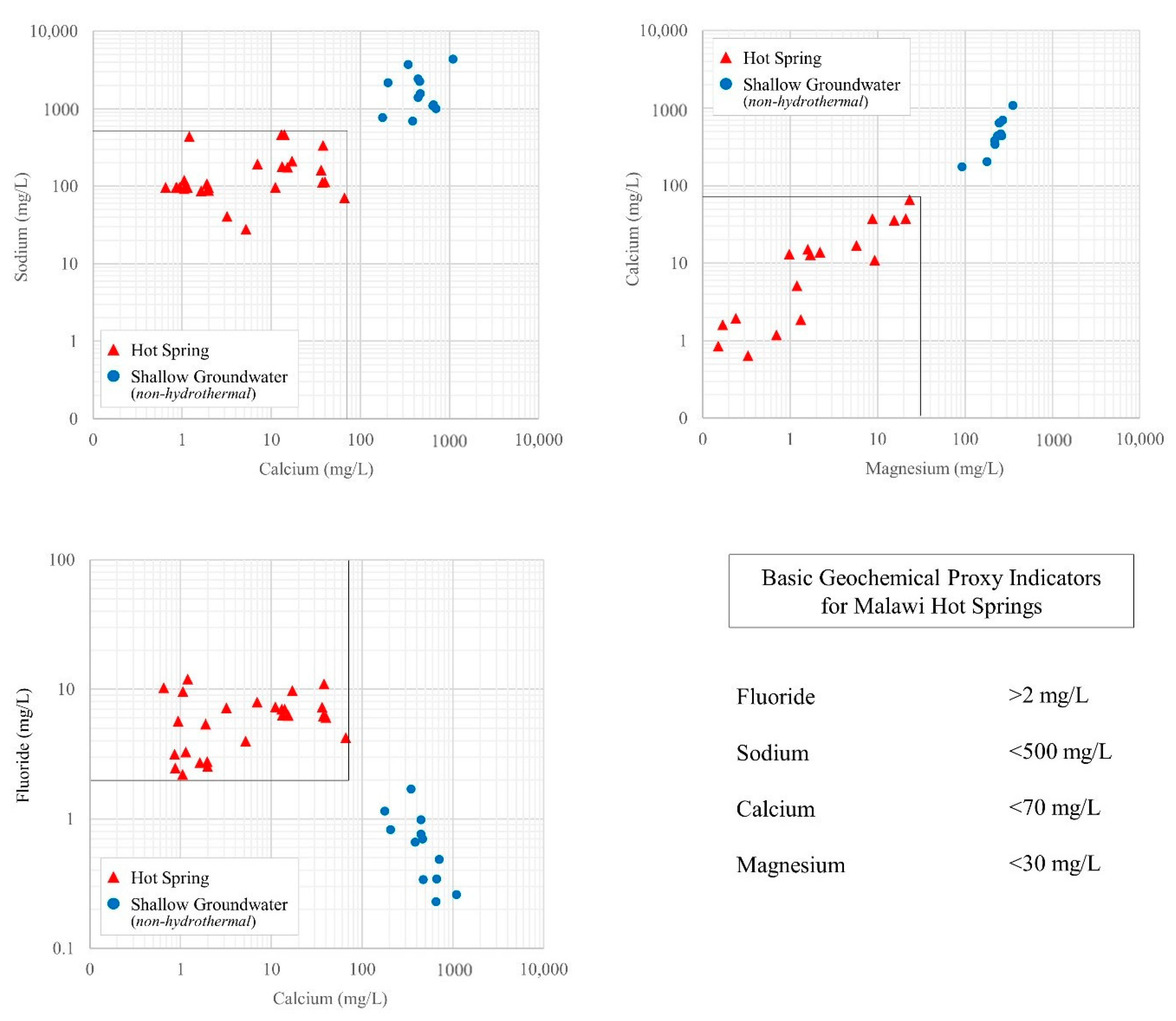
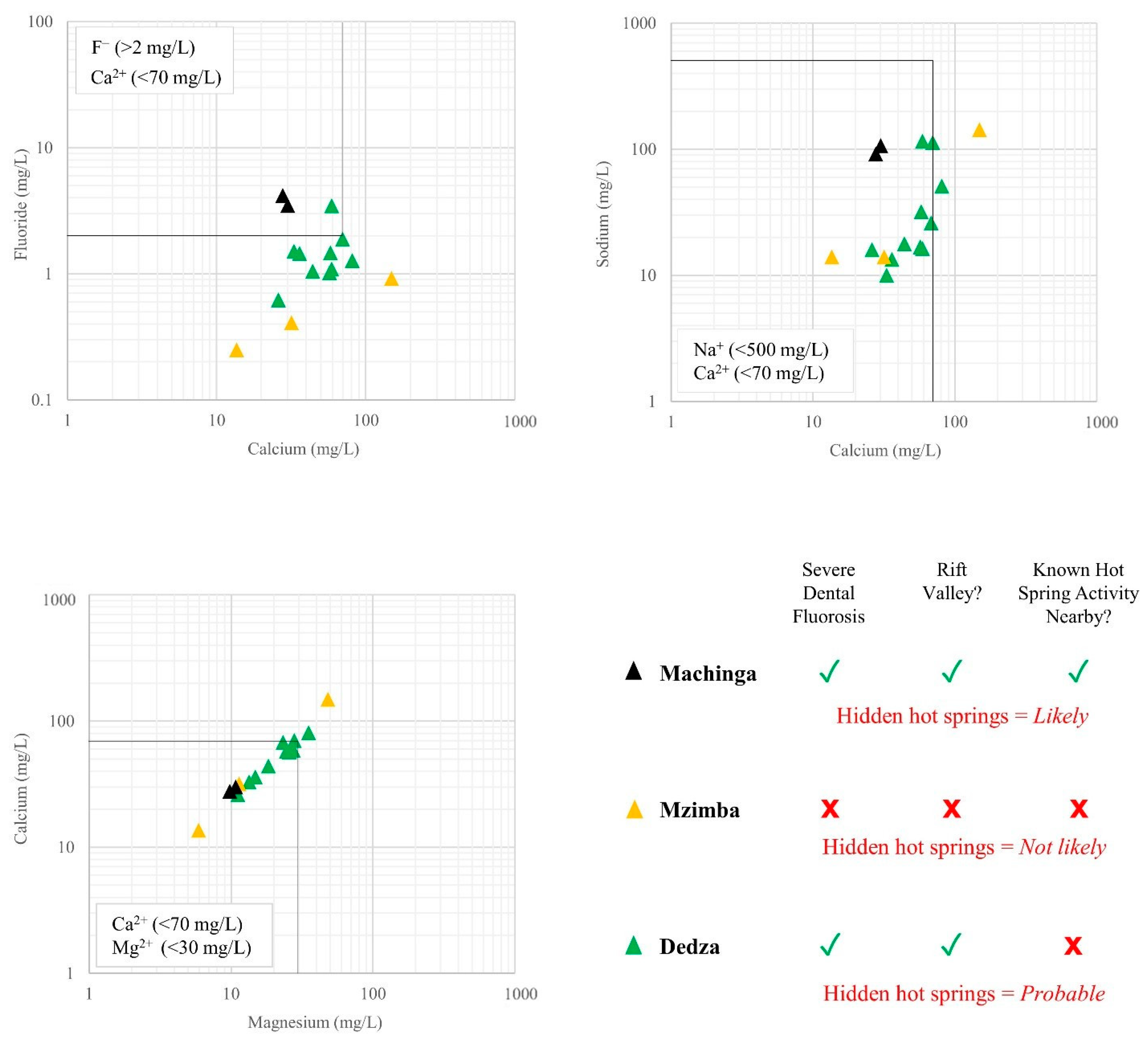
Four basic geochemical proxy indicators for hot spring activity were identified from the model data (F, Na+, Ca2+, Mg2+); each displayed a geochemical signature notably different for hot springs than for shallow (non-hydrothermal) groundwater samples from the same rift basin environment (Figure 4). Na+/Ca2+ and Ca2+/Mg2+ ratios displayed strong increasing linear trends from hot springs towards shallow groundwater samples with distinct groupings of each sample type: all samples displaying <500 mg/L Na+, <70 mg/L Ca2+ and <30 mg/L Mg2+ were hot springs [15,23,24]. Distinct groupings were also visible with the F/Ca2+ ratio where all samples with >2 mg/L F and <70 mg/L Ca2+ were hot springs. There was a significant gap (spanning an order of magnitude) of 108 mg/L between the maximum Ca2+ concentration of hot springs (66 mg/L) and the minimum Ca2+ concentration of non-hydrothermal samples (178 mg/L). The same gap in F concentrations was less significant at only 0.51 mg/L. The F/Ca2+ plot shows a decreasing linear trend in shallow groundwater samples which is expected due to fluorite (CaF2) equilibration occurring in shallow groundwater in Malawi’s rift basin alluvial aquifers, however, the trend is less obvious in hot spring samples, possibly due to oversaturation of fluorite (CaF2) (SI = 0–1) occurring in some hydrothermal waters [18].
Elevated fluoride is the significant proxy indicator; however, elevated fluoride by itself does not suggest hot spring activity. There are many reasons for groundwater samples to match the other three proxy indicators (<500 mg/L Na+, <70 mg/L Ca2+ and <30 mg/L Mg2+); however, when combined with elevated fluoride (>2 mg/L) they are shown represent hidden hot springs (Figure 4). The other three proxy indicators are thus intended to be used in conjunction with elevated fluoride which is why a sample must match all four to be classified as a hidden hot spring. Fluoride concentrations from the model data are significantly higher in hot springs when compared to shallow (non-hydrothermal) groundwater. Only 5% of shallow groundwater samples had fluoride concentrations which exceeded the WHO water quality limit of 1.5 mg/L with a maximum concentration of only 1.7 mg/L. In contrast, 100% of hot spring samples exceeded 1.5 mg/L, with 58% exceeding the current (very high) Malawian standard for untreated drinking water of 6 mg/L and a maximum concentration of 12 mg/L. The median groundwater fluoride concentration in hot springs (5.88 mg/L) is an order of magnitude higher than that of non-hydrothermal samples (Table 2).

3.2. Hidden Hot Spring Locations Identified from Archive Geochemical Data

A total of nine samples from the archive groundwater data set (n = 1026) matched all four geochemical proxy indicators for hot spring activity and were classified as hidden hot springs. Those locations represent drinking water points where groundwater samples from boreholes and wells reflect geochemical signatures identified to be indicative of Malawi hot springs, in contrast to the majority which reflect geochemical signatures identified to be indicative of non-hydrothermal shallow groundwater. Fluoride concentrations from hidden hot springs in the range 2–4.4 mg/L mostly reflect those of endmember hot springs from the model data, the obvious difference being a lack of concentrations exceeding 6 mg/L. That may be attributed to expected mixing trends with shallow groundwater in the unconsolidated rift basin aquifers which may dilute fluoride concentrations, or it may simply be that the hidden hot springs do not produce groundwater fluoride in the higher concentration range (>6 mg/L), as is the case with 40% of known hot springs from the model data (Table 2).
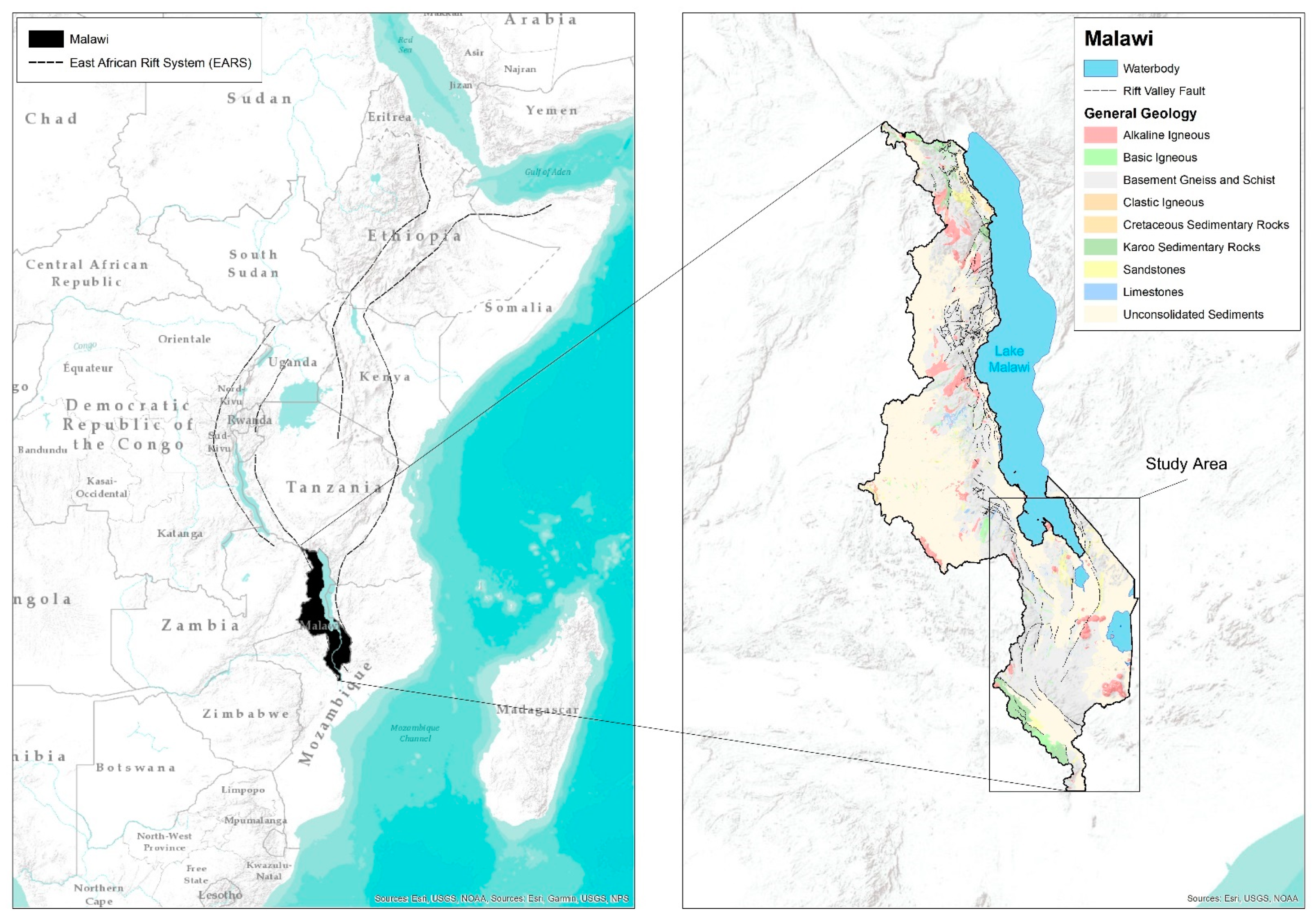
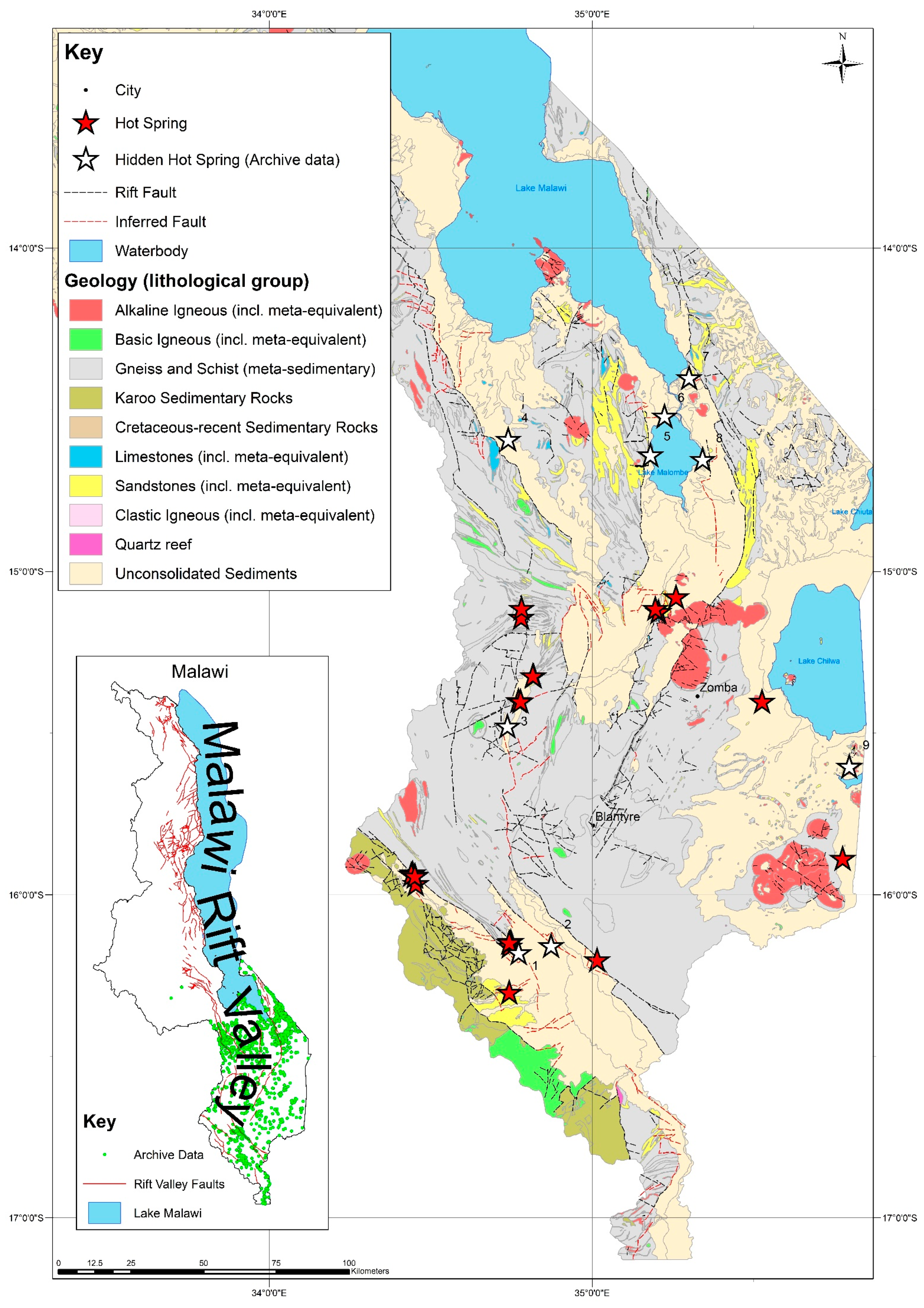
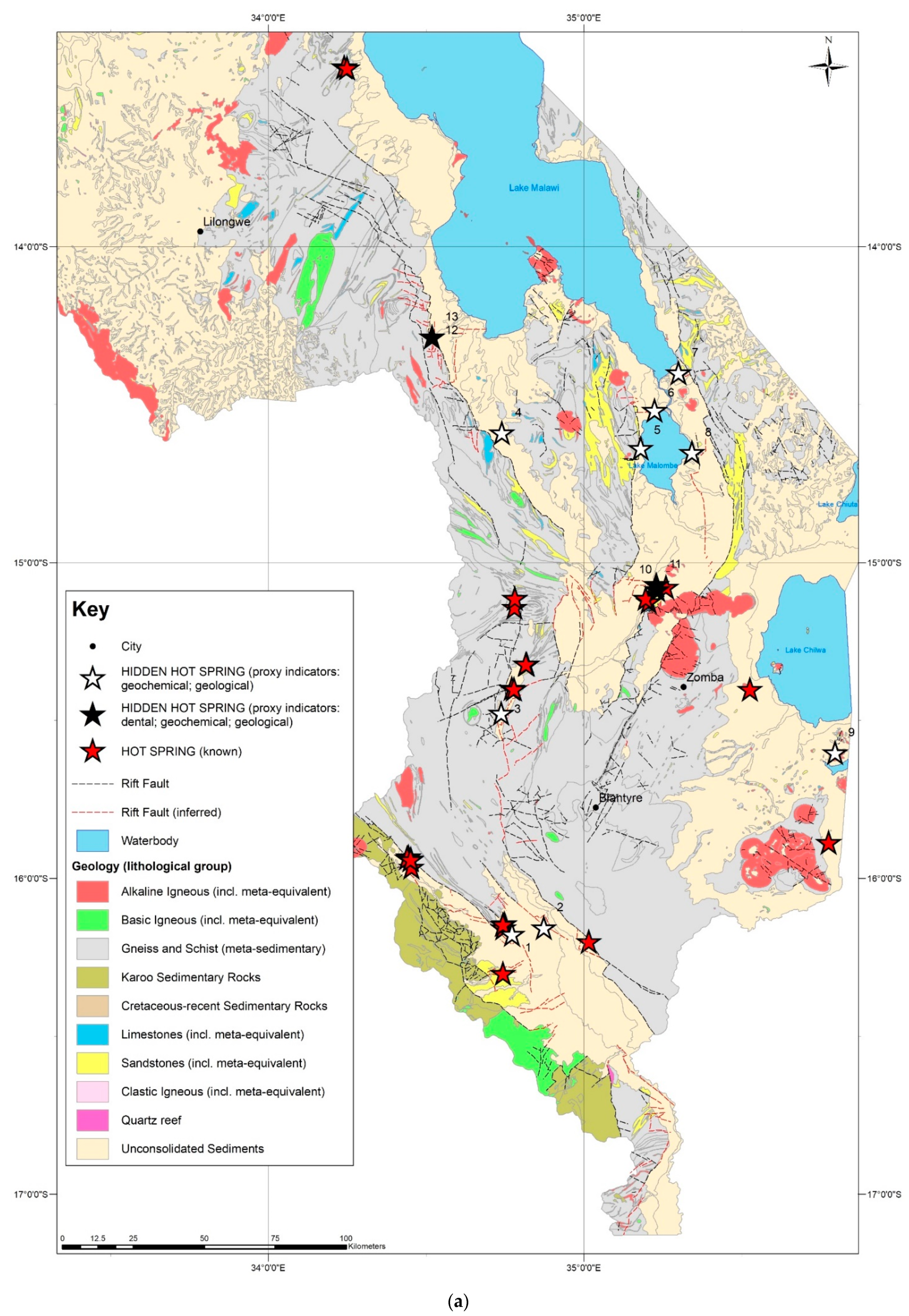
Hidden hot spring locations identified from the archive data by geochemical proxy indicators were plotted onto a map of regional geology and known hot spring locations for the southern part of Malawi (Figure 5). Additional to known faults, the map displays inferred faults in the rift valley as described in Section 2.3. Hidden hot spring locations are numbered 1–9. All (except one) hidden hot springs occur directly adjacent to a known or inferred fault within the rift valley (Figure 5). Three occur in faulted areas where there is known hot spring activity: one in the Middle Shire River Basin (3), ~40 km northwest of Blantyre, and two in the Lower Shire Basin (1,2), ~35–40 km south-southwest of Blantyre City. Five occur in the Upper Shire River Basin: four in a cluster around the shores of Lake Malombe and the southernmost shore of Lake Malawi (5,6,7,8), and one due west immediately proximal to a large rift margin normal fault (4). The only hidden hot spring to occur outside of the rift valley (~60 km southeast of Zomba City) is located in unconsolidated sediments in an area with no faulting immediately adjacent to an alkaline igneous intrusion composed of granite (9). The latter occurs in a region characterised by the occurrence of the Chilwa Alkaline Province (CAP), alkaline igneous intrusions (mostly plutons) associated with the most recent phase of rifting, and contains two known hot springs which are also located immediately adjacent to alkaline intrusions composed of granite and syenite (Figure 5).

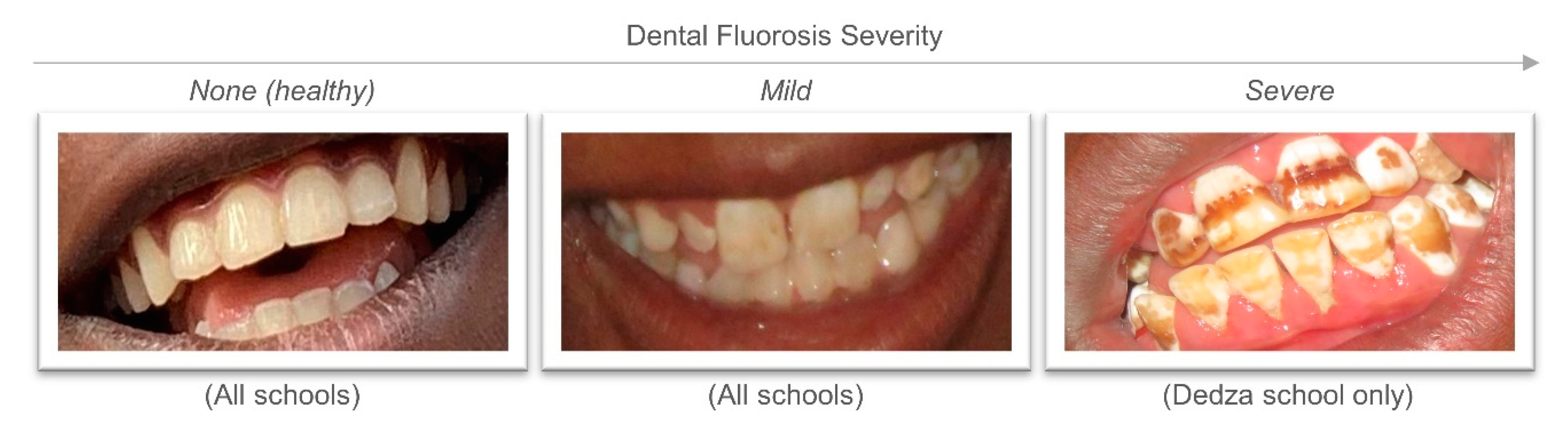
3.3. Severe Dental Fluorosis Incidence as a Proxy Indicator

Malawi literature on dental fluorosis was particularly sparse. The updated review found no new published works presenting dental fluorosis data since the original review [18]. Only one study (the same study identified by our original review) published data on dental fluorosis in school children [10]. The study investigated dental fluorosis at four schools inside the rift valley in Malawi’s Machinga District, two of which reported increased incidence of dental and severe dental fluorosis: Liwonde L.E.A School and Mtubwi Primary School (Figure 6). Pupils who were born or had lived in the area for more than two years were identified, then pupils from that group with dental and severe dental fluorosis were counted (standard 3 and 4 age). A significantly higher proportion of pupils presented signs of severe dental fluorosis at Mtubwi Primary School than at Liwonde L.E.A. School, despite being only 2 km apart. That was attributed to the fact that most households around Liwonde L.E.A. School obtain their drinking water from the Southern Region Water Board (treated surface water and in-piped network), rather than local boreholes, whilst most households around Mtubwi Primary School drink from local boreholes. The boreholes at both schools and those at surrounding villages all tested very high for fluoride concentrations (range: 3.2–10.3 mg/L), leading them to conclude that drinking water was the cause at both locations and classified the areas which included each school and their surrounding villages as “endemic fluorosis areas” [10]. Their data (two school locations with high incidence of severe dental fluorosis) were subsequently incorporated into this study as proxy indicator locations (from dental data—Table 1) for hidden hot springs (Figure 6). No information was presented on the methods of assessing fluorosis. The study was the best (and only) available dental fluorosis study in Malawi, with data, which could be utilised as proxy indicator locations for hidden hot springs.
Four of the schools visited by the dental team were located outside of the rift valley (Mzimba District) in Malawi’s Northern part, one school was located inside the rift valley directly adjacent to a large rift basin margin fault (Dedza District) in the Central part of the country (Figure 6). All school children from schools in Mzimba District exhibited no severe dental fluorosis, with only a small number (1–3% of all children examined) showing signs of mild dental fluorosis (Table 3). In contrast, Mua Primary School in Dedza District (the only school visited within the rift valley) had a much higher proportion of children with dental fluorosis (36% of all children examined) and was the only location where there were children with severe dental fluorosis (Figure 7). With severe dental fluorosis present only at that school (n = 50), it is likely that the location is near (or is within walking distance of) at least one water point with consistently elevated fluoride concentrations (i.e., water point hydraulically connected to a hidden hot spring). The small overall proportion of children with severe dental fluorosis (7% of all children examined) suggested that the fluoride source was likely highly localised, with possibly only one or two water points affecting a small geographical area where people use the source for their regular drinking water supply.

3.4. Groundwater Sampling at Locations Identified by Dental Data

School boreholes are used for drinking water supply at each of the schools sampled. Village boreholes are used for domestic drinking water supply. Two school boreholes from Machinga District and one village borehole from Dedza District (all three locations inside the rift valley) (Figure 6), plotted firmly within all four geochemical proxy indicators for hot spring activity and contained the highest fluoride concentrations of all locations (Figure 8). The remaining nine borehole samples from Dedza District (Mua Primary School and surrounding village boreholes) did not plot within all four proxy indicators. Eight samples plotted within proxy indicators for Ca2+, Na+, and Mg2+, but not for F; one which plotted very close to the F proxy indicator (1.88 mg/L), therefore, may represent a possible hidden hot spring sample which has been diluted. One sample did not plot within any proxy indicator. All except one sample from Dedza contained fluoride concentrations well below the WHO guideline standard of 1.5 mg/L (Figure 8). Two samples from Mzimba District plotted within all geochemical proxy indicators for hot spring activity except fluoride, with an upper concentration of only 0.92 mg/L F (Figure 8) which is well within the WHO guideline standard. The remaining sample from Mzimba District plotted out with all proxy indicators. As stated previously, only samples which match all four geochemical proxy indicators were considered as hidden hot spring locations, therefore only the Machinga District locations (Mtubwi and Liwonde L.E.A. school boreholes) and one Dedza District location (village borehole within 1.25 km of Mua Primary School) were considered as such using basic geochemical proxy indicators.
A more detailed geochemical analysis of the school and village samples was performed via a modified Piper plot (Figure 9) where chloride was replaced by fluoride (×10). As expected, hidden hot spring samples identified by dental, geological, and basic geochemical proxy indicators plot as a mixing between (model) hydrothermal and shallow groundwater endmembers. Hidden hot springs represent hydrothermal water diluted by shallow groundwater at the sediment base which is reflected clearly in the Piper plot. Basic geochemical proxy indicators in the previous section identified one possible hidden hot spring sample which matched all proxy indicators except fluoride (although was close at 1.88 mg/L). That sample plotted within the hidden hot springs cluster on the Piper plot (Figure 9), indicating that basic geochemical proxy indicators were 75% effective at identifying hidden hot springs from those data. However, the borehole is located less than 40 m from the Dedza hidden hot spring identified by basic geochemical proxy indicators and is potentially abstracting groundwater from the same hidden hot spring (albeit more diluted). The sample does, however, reflect a hidden hot spring geochemical profile on the Piper plot so was thus included as a fourth hidden hot spring from those data.
Schools within Mzimba District (our control group) do not occur within the rift valley, are at least 30 km from the nearest fault, have no known hot spring activity nearby, and did not show severe dental fluorosis in any of the children at the schools visited, so it was hypothesised that hidden hot springs at those locations were not likely. Groundwater sampling at those school boreholes confirmed the hypothesis; none of the samples matched all four geochemical proxy indicators for hot spring activity (Figure 8). School locations in Machinga District are located within the rift valley, do have known hot spring activity nearby and a high ratio of severe dental fluorosis in school children was reported [10], so hidden hot spring activity was hypothesised to be likely at that location. Sampling of the school boreholes confirmed that hypothesis: both school borehole groundwater samples matched all four geochemical proxy indicators for hot spring activity (Figure 8). The location of Mua Primary School within Dedza District does not have any known hot spring activity nearby, however the location is within the rift valley (directly proximal to a large active rift fault) and displayed increased incidence of medically confirmed severe dental fluorosis in school children (identified by our dental team). It was thus hypothesised that hidden hot spring activity was probable at that location. Groundwater sampling of the school borehole did not confirm that hypothesis; the groundwater sampled matched three geochemical proxy indicators but displayed a fluoride concentration of only 0.4 mg/L, and therefore did not suggest a hidden hot spring.
Lack of confirmation from groundwater sampling at Mua Primary School in Dedza District triggered a second round of groundwater sampling to widen the search radius and identify the source of groundwater causing severe dental fluorosis observed at the school. The rift valley location and the high incidence of severe dental fluorosis suggested a nearby borehole with groundwater containing consistent elevated fluoride concentration, likely well above 1.5 mg/L (due to the severity of dental fluorosis observed in the children at the school). The small overall proportion of children with severe dental fluorosis at the school (7%) (Table 3) suggested a highly localised source of groundwater fluoride. It was reasonably hypothesised that sampling of groundwater from those boreholes and wells within 1.25 km of the school (1.25 km radius was estimated based on the halfway distance to the next nearest school, assuming all children walk to school in rural Malawi) would yield at least one location with a groundwater geochemical signature identified to be indicative of hot springs. A hidden hot spring, discharging at the sediment base and mixing with shallow groundwater was therefore probable within that radius. The second groundwater sampling round confirmed the hypothesis: from 10 groundwater samples, one collected from a village borehole matched all four geochemical proxy indicators for hot spring activity and displayed a fluoride concentration of 3.46 mg/L (Figure 8).

3.5. Data Synthesis and Hidden Hot Spring Prediction

Results were collated to develop a hidden hot spring vulnerability prediction map of the southern part of Malawi (Figure 10a). Our analysis of severe dental fluorosis data resulted in an additional four hidden hot spring locations being added to the nine already identified from geochemical data. All four hidden hot springs from Machinga and Dedza Districts, originally identified by dental data and subsequently confirmed by geochemical data, were added as point source hidden hot spring locations and were numbered 10, 11, 12 and 13. (Figure 10).
Hidden hot springs 1 and 2 are located within the rift valley in an area with five known hot springs and numerous active rift faults. Hidden hot spring activity is therefore likely at that location. Hidden hot spring 1 occurs within basin sediments along a truncated fault which hosts known hydrothermal activity in the form of three hot springs (Figure 10). That particular location was the most likely candidate for a hidden hot spring due to its close proximity to both the fault and nearby known hot springs. Hidden hot spring 2 was located in the same rift basin sediments as 1 (Lower Shire Basin) immediately adjacent to a large rift fault (Figure 10). Whilst there were no known hot springs along that inferred rift basin normal fault, it was reasonable to assume that there may be hydrothermal discharge hidden beneath basin sediments, evidenced by known hot spring occurrence in the same area. The occurrence of a hidden hot spring (identified from geochemical data) along the same fault provides additional supporting evidence for that hypothesis. Basin sediments are deepest near the northwest-southeast-trending basin margin fault so hydrothermal discharge along faults which are not exposed at the surface would likely discharge in that manner. The known hot spring east of hidden hot spring 2 discharges along the basin margin fault (which is exposed at the surface) explaining why it occurs at the surface at that location, rather than the sediment base.
Hidden hot spring 3 displays a similar situation to 2, where there are known hot springs in the same (much smaller) basin directly related to active faults (Figure 10). Faulting is more complex in that area; the basin which hosts the hot springs and hidden hot spring is a mini fault-controlled rift basin within the larger Malawi Rift basin on its western flank (Figure 10). Proximity to active faults and known hot springs makes hidden hot spring 3 a likely candidate for hydrothermal discharge under those sediments and it is likely that additional water points located within that smaller basin would yield groundwater geochemical profiles indicative of hot springs, including elevated fluoride.
Hidden hot springs 5,6,7 & 8 are located on or immediately adjacent to faults within the rift valley between the eastern basin margin fault and an intra-rift graben to the west (Figure 10). The area around Lake Malombe and the southern extent of Lake Malawi is characterised by an absence of known hot spring activity. It may be that any hot springs in the area are hidden beneath basin sediments mixing with shallow groundwater which would explain the hidden hot spring geochemical profiles for those four water points. Their occurrence along active rift faults (inferred) provides supporting evidence for hidden hot springs at those locations. The fact that faults at those locations had to be inferred due to being buried beneath rift basin sediments supports the hypothesis that the hot springs may also be hidden, discharging at the sediment base.
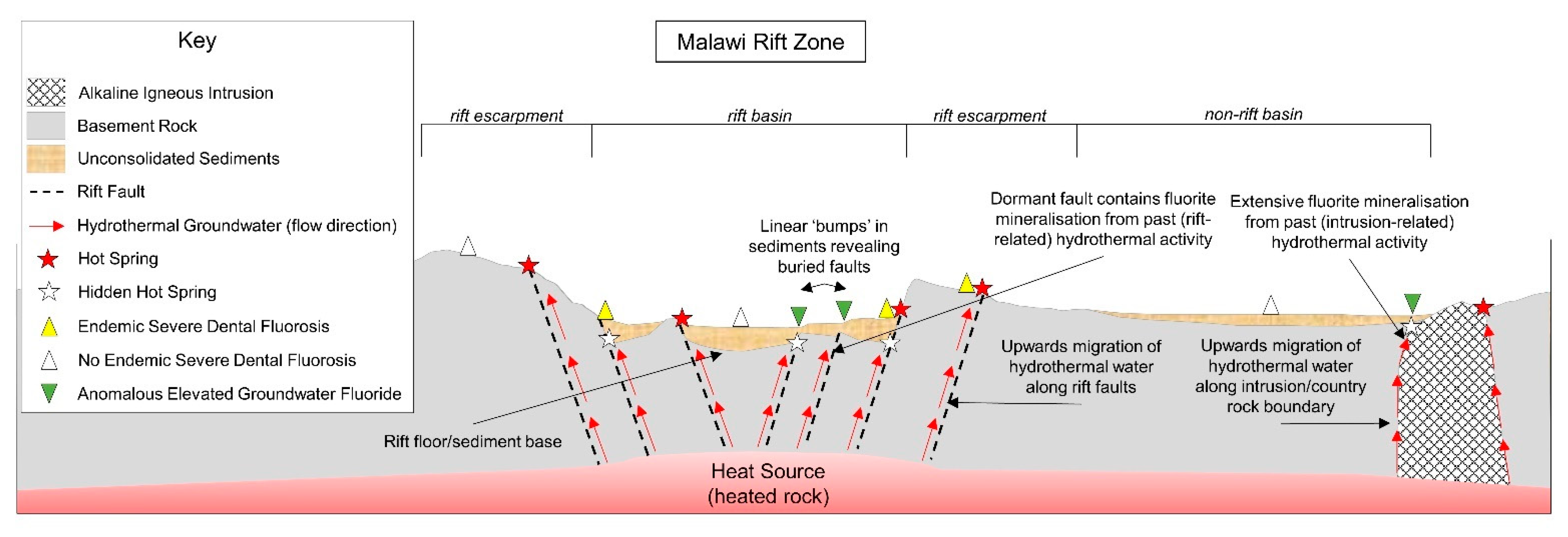
Hidden hot spring 9 is located adjacent to a CAP intrusion (Figure 10). Two other hot springs in that area occur adjacent to CAP intrusions in the same manner, allowing us to reasonably assume that the same process for hydrothermal discharge for those known hot springs is also responsible for the hidden hot spring in the same basin. Due to an absence of faults at this off-rift location the likely vertical transport mechanism for hydrothermal water is a country rock-intrusion lithological boundary in each case (Figure 2). Historical post-emplacement hydrothermal activity is evidenced by fluorite-apatite mineral veins associated with carbonatite cores in the region [32] indicating that there are additional fluid flow conduits (fractures) internally within the CAP intrusions which extend deep enough for hydrothermal fluid to exploit. Residual (decaying) Cretaceous-age heat from emplacement of the CAP intrusions [33] has been suggested as an additional source of hydrothermal heat in the region [17] indicating that hydrothermal activity is as likely within that ‘off-rift’ basin where the CAP intrusions occur, as it is within the rift valley.
Proxy hot springs 10 and 11 represent locations identified initially as possible hidden hot spring locations from severe dental fluorosis incidence data as a proxy indicator, which were later corroborated by geochemical proxy indicators from groundwater quality data collected to support dental data and thus classified as hidden hot springs. They were previously identified as endemic severe dental fluorosis areas using severe dental fluorosis incidence (non-medical observations) with observed elevated groundwater fluoride concentrations from borehole samples. Further study was recommended to determine the geological cause of elevated fluoride [10] which we have since achieved within our study. Sampling groundwater from the school boreholes for complete geochemical profiles (absent from literature) and subsequent cross-checking with our geochemical proxy indicators allowed us to reasonably hypothesise that hidden hot springs, discharging at the sediment base and mixing with shallow groundwater, were the most likely cause of observed elevated groundwater fluoride at those locations, thus explaining the geological cause of locally endemic severe dental fluorosis. Proximity to buried rift valley faults and three known hot springs further supported that hypothesis. The hydrothermal conduit which feeds the hidden hot springs is most likely a fault located ≈400 m west of hidden hot springs 10 and 11 (Figure 10b). It has been shown previously that hot springs discharging beneath sediments (similar to our hidden hot springs) contaminate shallow groundwater with elevated fluoride to a radial extent of 1 km [2]. Fluoride concentration data for the area around hidden hot springs 10 and 11 collected by [10] show elevated fluoride concentrations occurring over an area of ≈16 km2. Either there are multiple hidden hot springs beneath those sediments which are yet to be discovered, or radial hot spring contamination is more extensive in the aquifer, contaminating shallow groundwater over a wider area. Additional groundwater sampling for complete geochemical profiles from boreholes is recommended in the areas surrounding the schools to determine the extent of fluoride contamination from hidden hot springs locally. Hydrogeological investigations to determine hydraulic conductivity, transmissivity and flow direction within the unconsolidated aquifer would further support the development of an integrated conceptual model which may better describe hidden hot spring behaviour. Replacement water supplies are recommended in the interim for hidden hot springs 10 and 11 (school boreholes) as they are used daily by school children for drinking purposes and present an immediate oral health risk.
Hidden hot springs 4, 12 and 13 are located within unconsolidated sediments proximal to an active rift margin fault (hypothesised conduit for hydrothermal groundwater) on the rift valley side (Figure 10). That location makes them prime candidates for hot spring activity, particularly hidden hot springs 12 and 13 which are located directly proximal to the fault (even though there is no known hot spring activity nearby). Sediments are deepest at the basin margin, so it is likely that any hot spring activity along that fault may be buried. Furthermore, hydrothermal heat source along that segment of the Malawi Rift Valley may be depleted relative to locations further south due to an absence of nearby CAP intrusions which provide additional heat source for hydrothermal activity where they occur [17]. A depleted heat source may explain the observed absence of known hot spring activity along that section of the rift. There may be additional faulting beneath sediments at those locations which are not visible at the surface and therefore could not be inferred. Groundwater from hidden hot springs 12 and 13 are delivered via 60 m boreholes fitted with Afridev handpumps. The boreholes are public supply water points and serve around 1000 people for their daily domestic supply. The water points pose an immediate severe dental fluorosis risk and therefore replacement water supply should be acquired for those who rely upon them.
Overall, this study shows at least thirteen hidden hot springs in the southern part of Malawi currently discharging at the sediment base in the rift basin, mixing with shallow groundwater and contaminating drinking water locally with excess dissolved fluoride. Geochemical proxy indicators can be used to screen incomplete groundwater quality data to locate hidden hot springs in the unconsolidated basin sediments of Malawi’s Rift Valley. A Piper plot analysis of model endmember and experimental groundwater data with complete geochemical profiles supported the use of basic geochemical proxy indicators and showed them to be at least 75% effective (i.e., three out of four boreholes) at identifying boreholes connected to hidden hot springs from geochemical data. The remaining borehole is potentially connected to the same hidden hot spring identified at Dedza (Figure 10). If proven, those four boreholes would represent three hidden hot springs which would indicate the method is 100% effective at identifying hidden hot springs. Future analysis of incomplete groundwater data in Malawi should screen geochemical data for proxy indicators of hot spring activity and cross-check with dental data to corroborate. This work has additionally shown that locations with increased incidence of severe dental fluorosis, confirmed by dentists, are simple and useful primary proxy indicators for locating hidden hot spring activity, particularly schools as they represent pupils from a variety of nearby locations. Identification of locations in that manner allows subsequent groundwater sampling efforts investigating the causes of severe dental fluorosis to be targeted. Similarly, dental studies investigating dental fluorosis (mild or severe) can be targeted in areas predicted to have elevated groundwater fluoride levels, such as our previous work predicting generic lithological groundwater fluoride risk zones, site-specific sources of particularly elevated groundwater fluoride (known hot springs) [15], and hidden hot springs identified by this study. Conversely, dental caries preventative interventions may be necessary in areas predicted to have low groundwater fluoride (<0.5 mg/L). The pioneering geoscientist-dentist collaborative efforts have proved to be substantially productive for both disciplines, where data and results significantly enhance the ability for both to target respective sampling work. This work illustrates the substantial benefits of cross-discipline collaborations and project that such efforts will become increasingly important as Malawi works toward achieving Sustainable Development Goal (SDG) targets for drinking water and health within the 2030 deadline.

3.6. Recommendations

This study has shown that the drinking water fluoride standard in Malawi (from boreholes and shallow wells) of 6 mg/L [13] is too high as it is not aligned with observed oral health risks. It is recommended in the first instance that the Malawi fluoride standard is updated to the globally accepted WHO fluoride standard of 1.5 mg/L [12] to mitigate oral health risks posed by hidden hot springs. The update was recommended in our previous work via stepped progression where the standard would reduce initially to 4 mg/L and then to 1.5 mg/L over time [15]. Only two hidden hot springs have fluoride concentrations >4 mg/L and would benefit from the first phase of stepped progression. The remaining 11 would still be considered ‘safe’ until the final phase of stepped progression which would align their fluoride standard with the WHO. Until the fluoride standard is updated, fluoride-contaminated water points such as hidden hot springs will continue to pose significant health concerns where they are used for drinking purposes as they cannot be decommissioned. Each hidden hot spring represents a borehole supply of untreated groundwater and may provide daily domestic water supply for a large number of people; therefore, the need for replacement water supplies for hidden hot springs is immediate. Hot springs are associated with additional geogenic contaminants harmful to human health such as arsenic [34], so updating drinking water standards to align with geogenic health risks is both essential and urgent in Malawi.
Dental sampling to examine oral health risks is recommended at and immediately surrounding the locations identified as hidden hot springs (1–9: Figure 7) for severe dental fluorosis. Those locations were identified solely from groundwater quality data so severe dental fluorosis incidence associated with those water points is probable but remains unknown. It is likely people regularly use those water points for drinking purposes and are particularly vulnerable to the condition due to observed excess fluoride concentrations. This further underpins the need for swift review of the Malawi drinking water fluoride standard [15], followed by decommissioning of the affected water points and acquisition of replacement water supplies where possible.
Investigation of the lateral extent of fluoride contamination of shallow groundwater from hot springs (known or hidden) is recommended for each known hot spring and hidden hot spring location identified by this study. It is likely that contamination extent will vary from source to source, depending on degree of mixing, aquifer porosity/permeability, hydraulic gradient, dilution (with recharging water) and/or discharge rate of hydrothermal groundwater. A geochemical and/or oral health investigation of water points immediately surrounding hot springs and hidden hot springs may identify additional groundwater fluoride contamination sources which pose oral health risks.
PHREEQ geochemical modelling of groundwater evolution within Malawi’s Rift Valley is recommended to better understand mixing behaviour of hydrothermal groundwater with shallow groundwater in the unconsolidated sediments of the rift basin. A regional groundwater quality data set utilised to model groundwater geochemistry in an area with a hidden hot spring(s), may help to better describe the extent of contamination and the plume behaviour of specific hidden hot springs in the unconsolidated aquifers of Malawi’s Rift Valley.
It is recommended that both the Ministry of Health and Population, and the Ministry of Forestry and Natural Resources (responsible for water affairs) in Malawi work more collaboratively so that they each may refine and target national sampling efforts where their interests coincide, specifically updating groundwater standards (for fluoride—a requirement of the SDGs) and oral health (dental fluorosis and dental caries). Working together in this manner will reduce time spent assessing two very different areas of research which we have shown to be intrinsically linked.

4. Conclusions

Hot springs are linked to localised endemic severe dental fluorosis due to particularly elevated fluoride concentrations from hydrothermal groundwater contaminating rural drinking water supplies. We coin the term ‘hidden hot springs’ to describe hot springs which do not occur at the surface as springs per se, but rather are buried beneath the unconsolidated sediments of Malawi’s rift basin discharging hydrothermal water from depth to shallow groundwater. The buried nature of hidden hot springs presented a key challenge to identify. Archive groundwater data were too incomplete for standard geochemical modelling techniques (a common issue in Malawi), so a creative alternative was developed which synthesised multi-faceted proxy indicators for hot spring activity and used them to predict the locations of possible hidden hot springs in the southern part of Malawi. Basic geochemical proxy indicators (fluoride, sodium, calcium, magnesium) identified to be indicative of Malawi hot springs were used to identify nine hidden hot springs from a regional groundwater quality data set. Incidence of severe dental fluorosis was used to predict an additional three hidden hot springs where the condition was observed in school children. Locations were subsequently corroborated with geochemical proxy indicators from groundwater data collected reactively to support dental data which revealed an additional hidden hot spring.
Overall, thirteen hidden hot springs in Malawi were identified which are contaminating rural groundwater supplies with excess fluoride. A hidden hot spring vulnerability prediction map was developed for the region which is the first of its kind in Malawi. This study has shown that collaboration between geoscientists and dentists (an apparently unlikely combination), working together and sharing data in the same geographical areas, can significantly enhance respective research outputs due to the linked nature of both disciplines with respect to fluoride and dental fluorosis. Future geoscientist groundwater sampling for fluoride prediction can be targeted using dental data indicating severe dental fluorosis locations. Dentists on the other hand can better recognise local geological control over observed community oral health and studies investigating fluorosis or dental caries can be targeted using our groundwater fluoride prediction methods.

Author Contributions

Conceptualization, M.J.A.; methodology, M.J.A., N.M., V.M., L.M.D.M., J.B., and D.I.C.; software, M.J.A.; validation, M.J.A., M.O.R., O.L.P., N.M., V.M., A.D.M., L.M.D.M., J.B., D.I.C., P.P., I.M., E.M. and R.M.K.; formal analysis, M.J.A.; investigation, M.J.A., O.L.P., N.M., V.M.; resources, J.B., R.M.K.; data curation, M.J.A., A.D.M.; writing—original draft preparation, M.J.A.; writing—review and editing, M.J.A., M.O.R., O.L.P., N.M., V.M., A.D.M., L.M.D.M., J.B., D.I.C., P.P., I.M., E.M. and R.M.K.; visualization, M.J.A.; supervision, M.O.R., J.B. and R.M.K.; project administration, N.M., V.M., J.B. and R.M.K.; funding acquisition, R.M.K. All authors have read and agreed to the published version of the manuscript.

Funding

This research was funded by the Scottish Government, via the ‘Climate Justice Fund: Water Futures Programme’ under research grant HN-CJF-03 awarded to the University of Strathclyde (R.M. Kalin).

Institutional Review Board Statement

Smileawi/University of Glasgow Dental School Oral Health Survey: The study (Reference P.09/19/2788) was approved by the University of Malawi College of Medicine Research and Ethics Committee (COMREC).

Informed Consent Statement

Informed consent was obtained from all subjects involved in the study. Consent for each child to participate was through a ‘negative consent’ process. Parents received a letter and were asked to return the letter to the school if they did not want their child to participate.

Data Availability Statement

Data available on request due to restrictions. The data presented in this study are available on request from the corresponding author. The data are not publicly available due to institutional ownership restrictions.

Acknowledgments

We gratefully acknowledge Smileawi and the University of Glasgow Dental School for the opportunity to collaborate. We would like to individually acknowledge the final year dental students from the University of Glasgow (Rosanna Grimes, Paula Houston, Martin Laird, Katie Read-Challen and Kirsty Smith) and the University of Dundee (Abigail Gliksten) for their hard work and dedication examining oral health, conducting preliminary testing of school boreholes for groundwater fluoride and analysing data during Malawi field work. We additionally acknowledge essential members of the Smileawi and University of Glasgow team: Conor O’Brien and Daniel O’Brien who assisted with recording data, Heather Lancaster who coordinated the project so that it ran smoothly and Rhona Ferguson for database management support for survey data. We would also like to acknowledge the continued engagement from the Government of Malawi, specifically the Ministry of Forestry and Natural Resources (previously the Ministry of Agriculture, Irrigation and Water Development) for swift data collection and for reviewing and providing detailed feedback on manuscripts.

Conflicts of Interest

The authors declare no conflict of interest.

References

  1. Edmunds, W.M.; Smedley, P.M. Fluoride in natural waters. Essent. Med Geol. 2013, 2, 311–336. [Google Scholar]
  2. Kundu, N.; Panigrahi, M.K.; Sharma, S.P.; Tripathy, S. Delineation of fluoride contaminated groundwater around a hot spring in Nayagarh, Orissa, India using geochemical and resistivity studies. Environ. Geol. 2002, 43, 228–235. [Google Scholar]
  3. Lottermosser, B.G.; Cleverley, J.S. Controls on the genesis of a high fluoride thermal spring: Innot Hot Springs, north Queensland. Aust. J. Earth Sci. 2007, 54. [Google Scholar] [CrossRef]
  4. Sracek, O.; Wanke, H.; Ndakunda, N.N.; Mihaljevic, M.; Buzek, F. Geochemistry and fluoride levels of geothermal springs in Namibia. J. Geochem. Explor. 2015, 148, 96–104. [Google Scholar] [CrossRef]
  5. Haji, M.; Wang, D.; Li, L.; Qin, D.; Guo, Y. Geochemical Evolution of Fluoride and Implication for F Enrichment in Groundwater Example from the Bilate River Basin of Southern Main Ethiopian Rift. Water 2018, 10, 1799. [Google Scholar] [CrossRef] [Green Version]
  6. Ghiglieri, G.; Pittalis, D.; Cerri, G.; Oggiano, G. Hydrogeology and hydrogeochemistry of an alkaline volcanic area: The NE Mt. Meru slope (East African Rift—Northern Tanzania). Hydrol. Earth Syst. Sci. 2012, 16, 529–541. [Google Scholar] [CrossRef] [Green Version]
  7. Nair, K.R.; Manji, F.; Gitonga, J.N. The occurrence and distribution of fluoride in groundwaters of Kenya. East Afr. Med. J. 1984, 61, 503–512. [Google Scholar]
  8. Tekle-Haimanot, R.; Melaku, Z.; Kloos, H.; Reimann, C.; Fantaye, W.; Zerihun, L.; Bjorvatn, K. The geographic distribution of fluoride in surface and groundwater in Ethiopia with an emphasis on the Rift Valley. Sci. Total Environ. 2006, 367, 182–190. [Google Scholar] [CrossRef]
  9. Shitumbanuma, V.; Tembo, F.; Tembo, J.M.; Chilala, S.; Van Ranst, E. Dental fluorosis associated with drinking water from hot springs in Choma district in southern province, Zambia. Environ. Geochem. Health 2007, 29, 51–58. [Google Scholar] [CrossRef]
  10. Sajidu, S.M.; Masumbu, F.F.F.; Fabiano, E.; Ngongondo, C. Drinking water quality and identification of fluoritic areas in Machinga, Malawi. Malawi J. Sci. Technol. 2007, 8, 42–56. [Google Scholar]
  11. Ozsvath, D.L. Fluoride concentrations in a crystalline bedrock aquifer Marathon County, Wisconsin. Environ. Earth Sci. 2006, 50, 132–138. [Google Scholar] [CrossRef]
  12. WHO. Guidelines for Drinking-Water Quality: Fourth Edition Incorporating the First Addendum; World Health Organization: Geneva, Switzerland, 2017. [Google Scholar]
  13. Malawi Bureau of Standards. Borehole and Shallow Well Water—Specification; Malawi Standards Board: Blantyre, Malawi, 2005. [Google Scholar]
  14. Lacson, C.F.Z.; Lu, M.-C.; Huang, Y.-H. Fluoride-containing water: A global perspective and a pursuit to sustainable water defluoridation management -An overview. J. Clean. Prod. 2020, 280. [Google Scholar] [CrossRef]
  15. Addison, M.J.; Rivett, M.O.; Phiri, P.; Mleta, P.; Mblame, E.; Wanangwa, G.; Kalin, R.M. Predicting groundwater vulnerability to geogenic fluoride risk: A screening method for Malawi and an opportunity for national policy redefinition. Water 2020, 12, 3123. [Google Scholar] [CrossRef]
  16. Khamula, O.; Faiti, O. Malawi Hit by Dentists Shortage: First Dental College Opens 2019. Nyasa Times. Available online: https://www.nyasatimes.com/malawi-hit-by-dentists-shortage-first-dental-college-opens-2019/ (accessed on 18 February 2021).
  17. Ninju, E.A.; Kolawole, F.; Atekwana, E.A.; Stamps, D.S.; Atekwana, E.A.; Abdelsalam, M.G.; Mickus, K.L. Terrestrial heat flow in the Malawi Rifted Zone, East Africa: Implications for tectono-thermal inheritance in continental rift basins. J. Volcanol. Geotherm. Res. 2019, 387. [Google Scholar] [CrossRef]
  18. Addison, M.J.; Rivett, M.O.; Robinson, H.; Fraser, A.; Miller, A.V.M.; Phiri, P.; Mleta, P.; Kalin, R.M. Fluoride occurrence in the lower East African Rift System, Southern Malawi. Sci. Total Environ. 2020, 712, 136260. [Google Scholar] [CrossRef] [PubMed]
  19. Dulanya, Z. Geothermal resources of Malawi—An overview. In Proceedings of the 31st Workshop on Geothermal Reservoir Engineering, Stanford University, Stanford, CA, USA, 30 January–1 February 2006. [Google Scholar]
  20. Dulanya, Z.; Morales-Simfors, N.; Sivertun, A. A comparison between silica and cation geothermometry of the Malawi hotsprings. In Proceedings of the World Geothermal Congress 2010, Bali, Indonesia, 25–29 April 2010. [Google Scholar]
  21. Gondwe, K.T.; Allen, A.; Georgsson, L.S.; Chakhala, H.; Tsokonombwe, G. Geothermal Development in Malawi—A Country Update. In Proceedings of the World Geothermal Congress 2015, Melbourne, Australia, 19–25 April 2015. [Google Scholar]
  22. Kaonga, H.; Tsokonombwe, G.; Kamanga, T. Status of geothermal exploration in Malawi. In Proceedings of the Proceedings 5th African Rift Geothermal Conference, Arusha, Tanzania, 29–31 October 2014. [Google Scholar]
  23. Kirkpatrick, I.M. The Thermal Springs of Malawi. XXIII Int. Geol. Congr. 1969, 19, 111–120. [Google Scholar]
  24. Msika, B.J.W.; Kalenga Saka, J.D.; Dulanya, Z. Spatial distribution, chemistry and subsurface temperatures of geothermal springs in Nkhata bay, Malawi. Afr. J. Environ. Sci. Technol. 2014, 8, 464–475. [Google Scholar]
  25. Wedmore, L.N.J.; Biggs, J.; Williams, J.N.; Fagereng, A.; Dulanya, Z.; Mphepo, F.; Mdala, H. Active fault scarps in Southern Malawi and their implications for the distribution of strain in incipient continental rifts. Tectonics 2020, 39. [Google Scholar] [CrossRef] [Green Version]
  26. Addison, M.J.; Rivett, M.O.; Phiri, P.; Mleta, P.; Mblame, E.; Kanjaye, M.; Phiri, O.; Lakudzala, W.; Kalin, R.M. Identifying Groundwater Fluoride Source in a Weathered Basement Aquifer in Central Malawi: Human Health and Policy Implications. Appl. Sci. 2020, 10, 5006. [Google Scholar] [CrossRef]
  27. Cannon, R.T. Geological Atlas of Malawi, 1st ed.; Government of Malawi: Lilongwe, Malawi, 1970.
  28. NDIP. National Dental Inspection Programme. NHS Scotland 2019. Available online: https://ndip.scottishdental.org/ (accessed on 12 December 2020).
  29. Macpherson, L.M.; Conway, D.I.; Gilmour, W.H.; Petersson, L.G.; Stephen, K.W. Photographic assessment of fluorosis in children from naturally fluoridated Kungsbacka and non-fluoridated Halmstad, Sweden. Acta Odontol. Scand. 2007, 65, 149–155. [Google Scholar] [CrossRef]
  30. Conway, D.I.; MacPherson, L.M.; Stephen, K.W.; Gilmour, W.H.; Petersson, L.G. Prevalence of dental fluorosis in children from non-water-fluoridated Halmstad, Sweden: Fluoride toothpaste use in infancy. Acta Odontol. Scand. 2005, 63, 56–63. [Google Scholar] [CrossRef] [PubMed]
  31. Thylstryp, A.; Fejerskov, O. Clinical appearance of dental fluorosis in permanent teeth in relation to histologic changes. Community Dent. Oral Epidemio. 1978, 6, 315–328. [Google Scholar] [CrossRef] [PubMed]
  32. Broom-Fendley, S.; Brady, A.E.; Horstwood, M.S.; Woolley, A.R.; Mtegha, J.; Wall, F.; Dawes, W.; Gunn, G. Geology, geochemistry and geochronology of the Songwe Hill carbonatite, Malawi. J. Afr. Earth Sci. 2017, 134, 10–23. [Google Scholar] [CrossRef] [Green Version]
  33. Eby, G.N.; Roden-Tice, M.; Krueger, H.L.; Ewing, W.; Faxon, E.H.; Woolley, A.R. Geochronology and cooling history of the northern part of the Chilwa Alkaline Province, Malawi. J. Afr. Earth Sci. 1995, 20, 275–288. [Google Scholar] [CrossRef]
  34. Rivett, M.O.; Robinson, H.; Wild, L.; Melville, J.; McGrath, L.; Phiri, P.; Flink, J.; Wanangwa, G.; Mlwta, P.; MacLeod, S. Arsenic occurrence in Malawi groundwater. J. Appl. Sci. Environ. Manag. 2018, 22, 1807. [Google Scholar] [CrossRef] [Green Version]
Figure 1. Left Malawi’s location on the African continent at the southern periphery of the East African Rift System (EARS). Right Topographical map of Malawi with generalised geology and rift-related faulting within the Malawi Rift Valley.
Water 13 01106 g001
Figure 2. Schematic cross-sectional conceptual model of the study area showing mechanisms responsible for hot spring and hidden hot spring occurrences of different types. Image is intended as an idealised example and is not to scale.
Water 13 01106 g002
Figure 3. Map of Malawi showing locations of model hot spring and shallow groundwater data.
Water 13 01106 g003
Figure 4. Basic geochemical proxy indicators for hot spring activity, identified from the model data, collected directly from hot springs and supply boreholes within the Malawi Rift Valley. All shallow groundwater samples were non-hydrothermal and occurred within rift basin sediments.
Water 13 01106 g004
Figure 5. Regional geological map of the southern part of Malawi showing locations of all known hot springs (red stars) and hidden hot springs (white stars) identified from the archive data using geochemical proxy indicators. Hidden hot spring locations are numbered 1–9. Map shows known rift faults (black dashed lines) and inferred rift faults (red dashed lines) which have been projected to display hidden faulting in basement rock buried beneath sediment cover in the rift basin. Inset: Simplified map of Malawi showing the Malawi Rift valley, distribution of rift valley faults, and distribution of archive (groundwater) data points prior to application of proxy indicators (n = 1026).
Water 13 01106 g005
Figure 6. Map of Malawi showing locations of schools sampled during dental surveys for dental fluorosis in children. Four schools in Mzimba District and one school in Dedza District were sampled by our dental team (Smileawi and the University of Glasgow Dental School) in 2019. Two schools in Machinga District were identified from Malawi literature as being endemic severe dental fluorosis areas [10].
Water 13 01106 g006
Figure 7. Examples of photographic images of school children’s anterior teeth from the Smileawi/University of Glasgow dental survey showing increasing severity of dental fluorosis. Severe dental fluorosis was only found at Mua Primary School in Dedza District. Dental fluorosis at mild levels appears as small, white opacities of teeth with minimal concern, however at moderate levels teeth can be mottled and cause aesthetic concern. More severe levels can lead to pitting and staining of enamel with loss of enamel integrity leading to tooth breakdown [31].
Water 13 01106 g007
Figure 8. Geochemical data from school and village boreholes at Mzimba and Dedza, and those schools identified in Malawi literature as endemic fluorosis areas in Machinga District [10]. Black lines indicate geochemical proxy indicators for hot spring activity identified from the model data (Figure 4). lower right: Additional proxy indicators for hot spring activity (Table 1) for each area, with an overall prediction for hidden hot spring occurrence at each location.
Water 13 01106 g008
Figure 9. Piper plot displaying model data from endmember hot springs with complete hydrochemical profiles (n = 5) [23], non-hydrothermal shallow groundwater with complete hydrochemical profiles (n = 2) [26], and experimental data from Machinga, Dedza and Mzimba collected for this study.
Water 13 01106 g009
Figure 10. (a) Hidden hot spring vulnerability prediction map of the southern part of Malawi. Data are plotted onto regional geology to provide geological context to hidden hot spring locations. Hidden hot springs identified from geochemical data only, and those identified from dental data which were subsequently confirmed by geochemical proxy indicators, are displayed separately. (b) Local-scale geological maps showing hidden hot spring locations from (a), scaled to provide more detail on geology, known hot spring locations and rift valley faults (observed and inferred).
Water 13 01106 g010aWater 13 01106 g010b
Table 1. Proxy indicators for hot spring activity considered within this study to locate and identify hidden hot springs in the southern part of Malawi’s unconsolidated rift basin sediments.
Proxy IndicatorQuestionExplanationPotential Issues
GeologicalIs the location within the rift valley? Hot springs in Malawi are caused by heat associated with continental rifting so locations within the rift valley are much more vulnerable to hydrothermal activity.
Dental HealthIs there increased localised incidence of severe dental fluorosis?Dental fluorosis is caused by excess fluoride ingestion, particularly from drinking water. Increased localised incidence of severe dental fluorosis suggests that there is a water source nearby which consistently produces water with particularly elevated fluoride concentrations.
GeochemicalDoes drinking water geochemistry from boreholes and wells match geochemical proxy indicators identified to be indicative of Malawi hot springs?Hot spring groundwater displays distinctly different geochemical signatures to shallow, non-hydrothermal groundwater. A combination of specific dissolved elemental concentrations was shown to be exclusive to Malawi hot springs and can be used as proxy indicators (discussed later).
* Groundwater TemperatureIs local groundwater temperature anomalously elevated?Hot springs are thermal groundwaters and usually reflect higher temperatures (>32 °C) than those of shallow groundwaters in Malawi (22–28 °C).Mixing with shallow groundwater within aquifers may lower hydrothermal groundwater temperatures.
* Known Hydrothermal ActivityIs there known hydrothermal activity nearby?The occurrence of known hydrothermal activity in an area is a reasonable indication that there may be undiscovered hot springs in the same area.Not effective in areas where all hydrothermal activity is hidden beneath rift valley sediments.
* Secondary proxy indicators—subject to issues which may render them ineffective.
Table 2. Summary statistics of groundwater fluoride concentrations from the model data (hot springs and shallow groundwater shown separately), and hidden hot springs identified from the archive groundwater data set.
Data SetnFluoride Concentration (mg/L)
<1.5>1.51.5–6>6Min.Max.MeanMedianStd. Dev.
Model Data
(shallow groundwater)
1294.74%5.26%5.26%0%0.231.700.700.660.38
Model Data
(hot springs)
260%100%42%58%2.2112.005.775.882.81
Archive Groundwater (hidden hot springs)90%100%100%0%2.004.402.762.550.75
Table 3. Number and Percentage of children with dental fluorosis and severe dental fluorosis at each of the schools which were sampled by both dental and groundwater sampling teams. Percentage values for ‘all fluorosis’ and ‘severe fluorosis’ reflect the proportion of the total number of pupils examined at each school in each case.
School NameDistrictNo. of Pupils ExaminedAll FluorosisSevere Fluorosis
n%n%
Ekwaiweni Primary SchoolMzimba7018100
Dunduzu Primary SchoolMzimba6146100
Malivenji Primary SchoolMzimba4628200
Ekwendeni School for the blindMzimba321300
Mua Primary SchoolDedza67924336507
Publisher’s Note: MDPI stays neutral with regard to jurisdictional claims in published maps and institutional affiliations.

