
Integrating Geomorphological Data, Geochronology and Archaeological Evidence for Coastal Landscape Reconstruction, the Case of Ammoudara Beach, Crete


Abstract
:1. Introduction
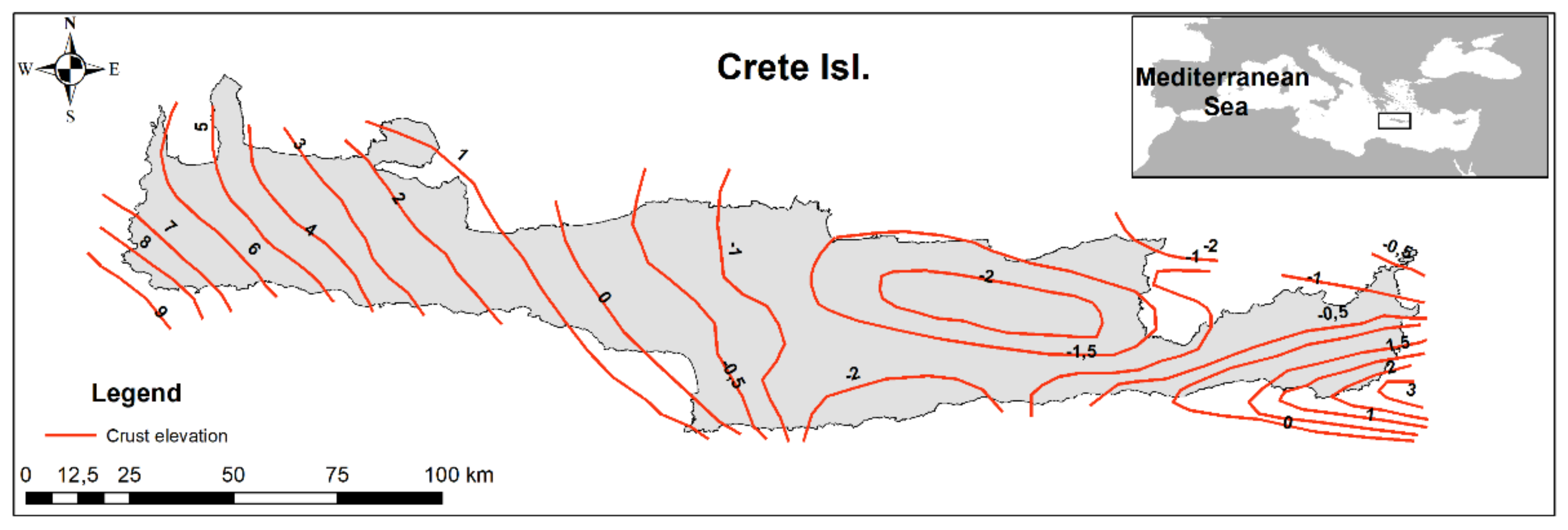
1.1. Tectonics of Crete
1.2. Indicators of Sea Level Changes on Crete
1.3. Beachrocks and Aeolian Deposits
1.4. Coastal Erosion
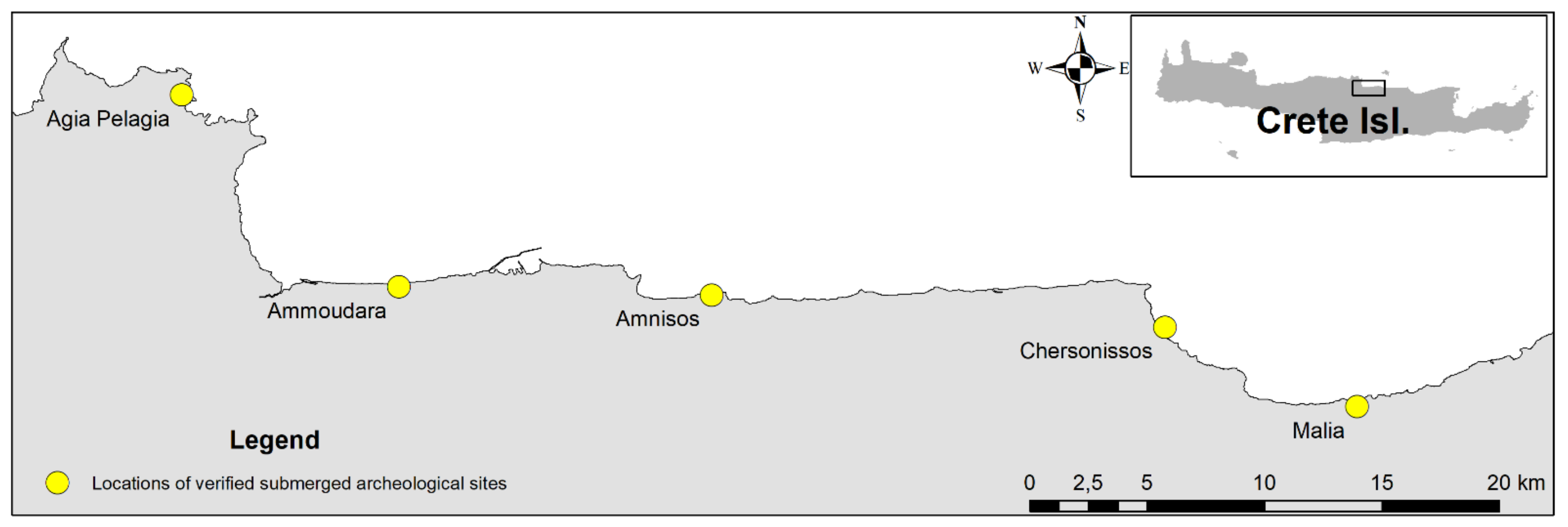
1.5. Archaeological Setting
1.6. Optically Stimulated Luminescence (OSL) Dating
2. Study Area
3. Materials and Methods
3.1. Optically Stimulated Luminescence (OSL)
3.2. OSL Measurements and Equivalent Dose (EDs) Calculations
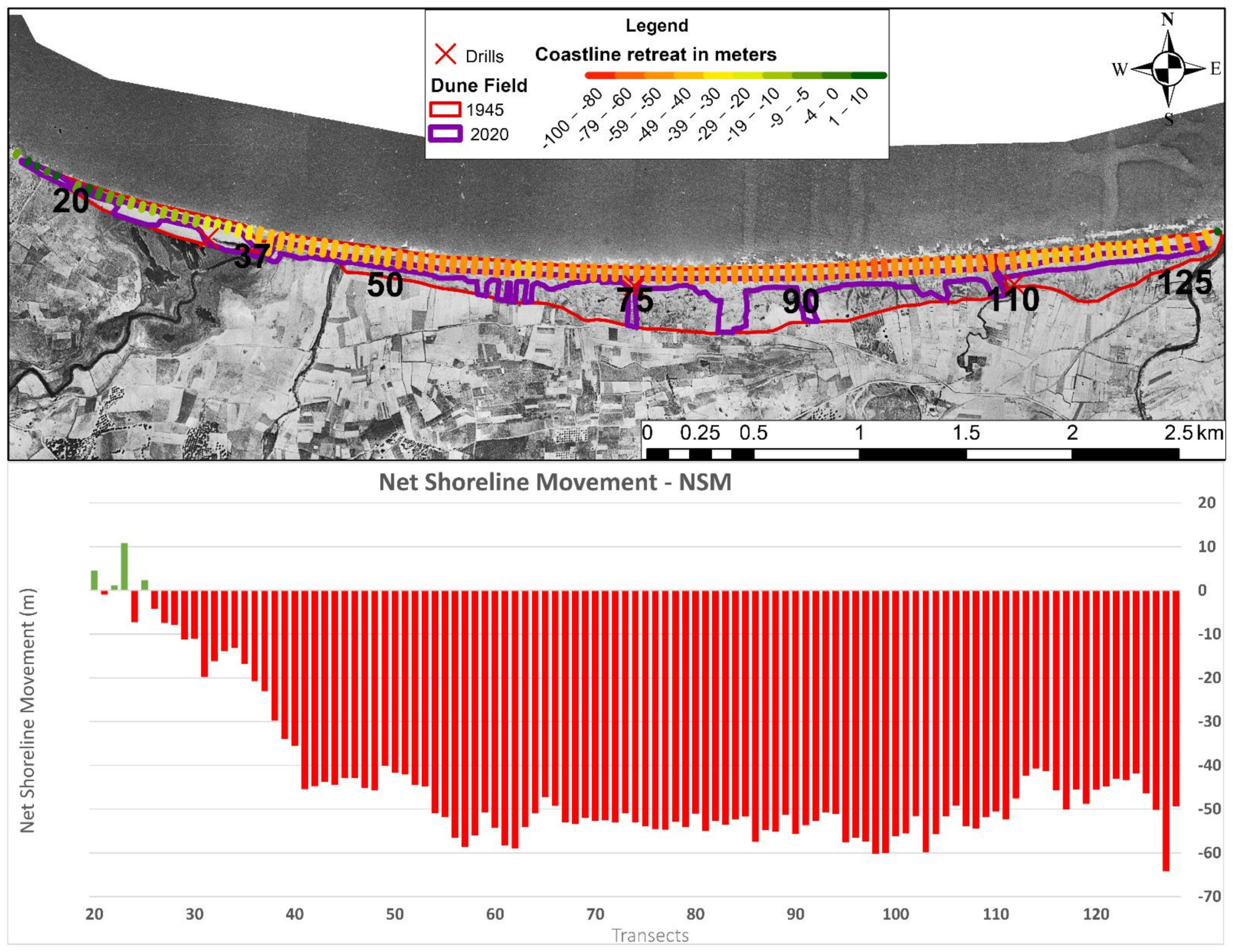
3.3. Coastline Evolution
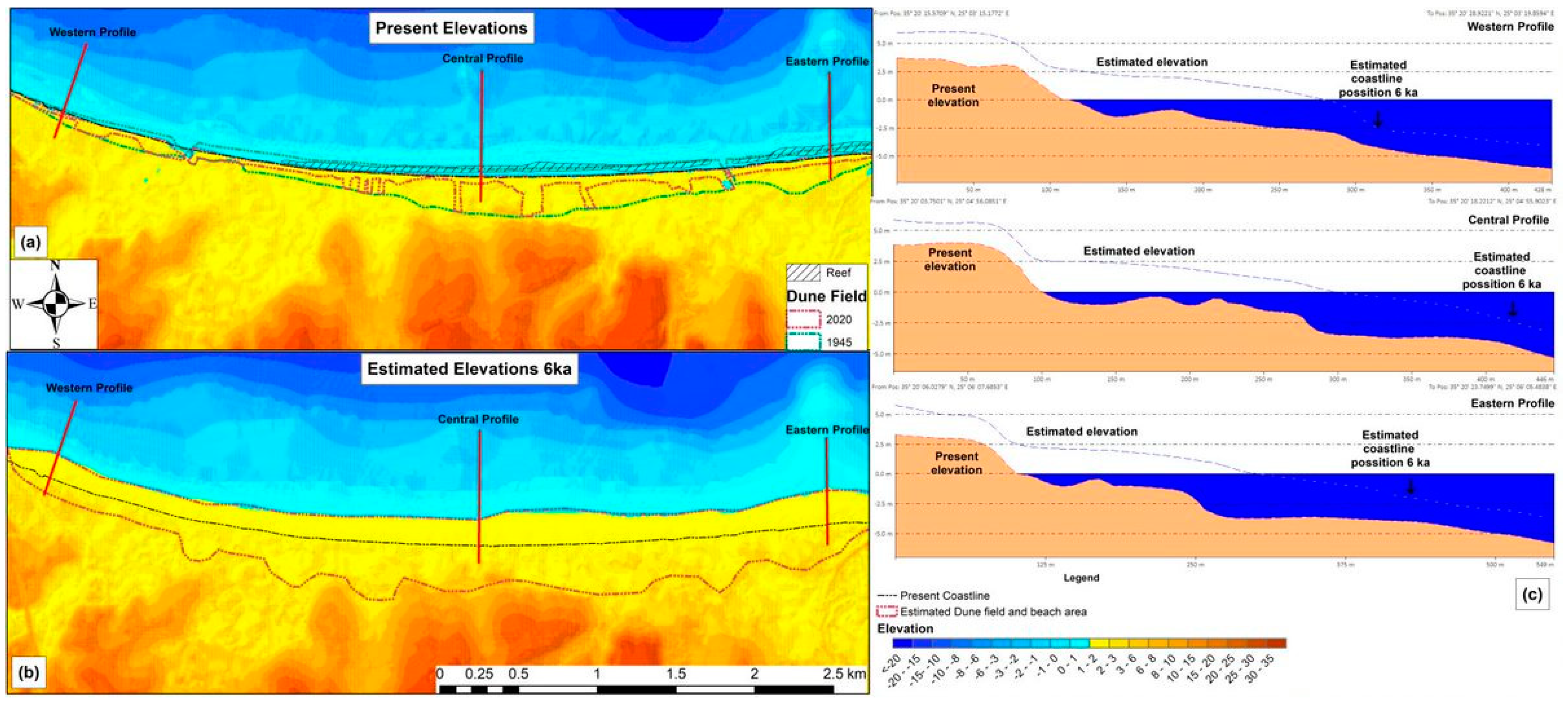
3.4. Terrain Visualisation
4. Results
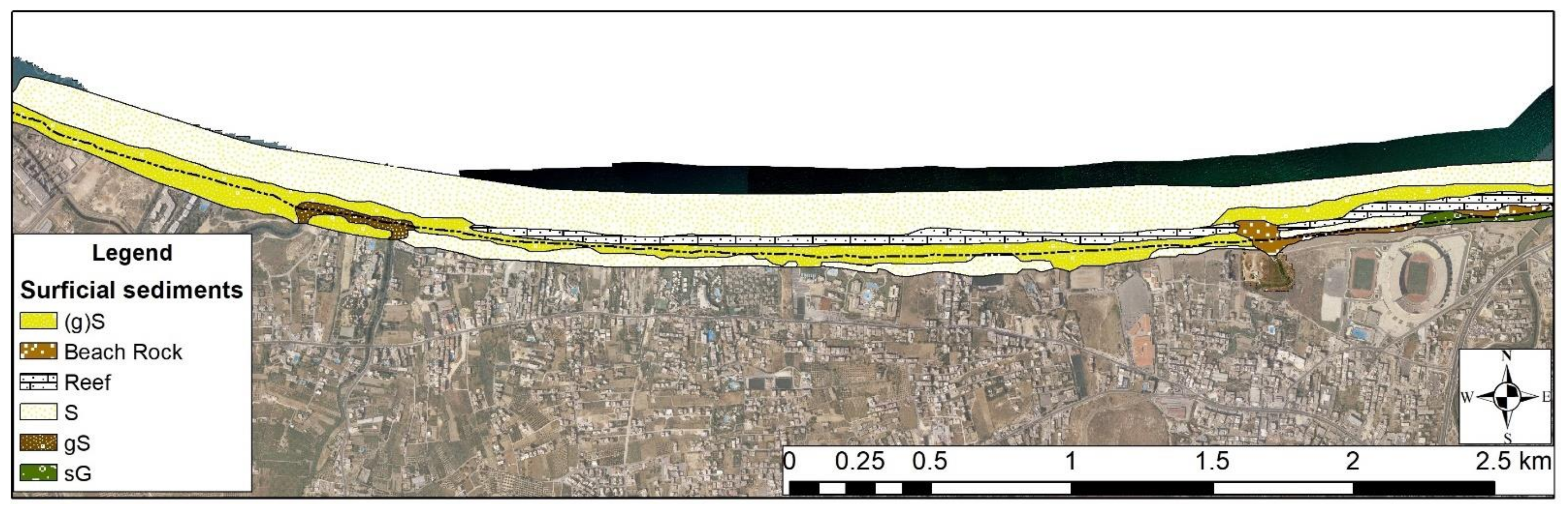
4.1. Textural Characteristics
4.2. Coastal Evolution
4.3. Stratigraphy
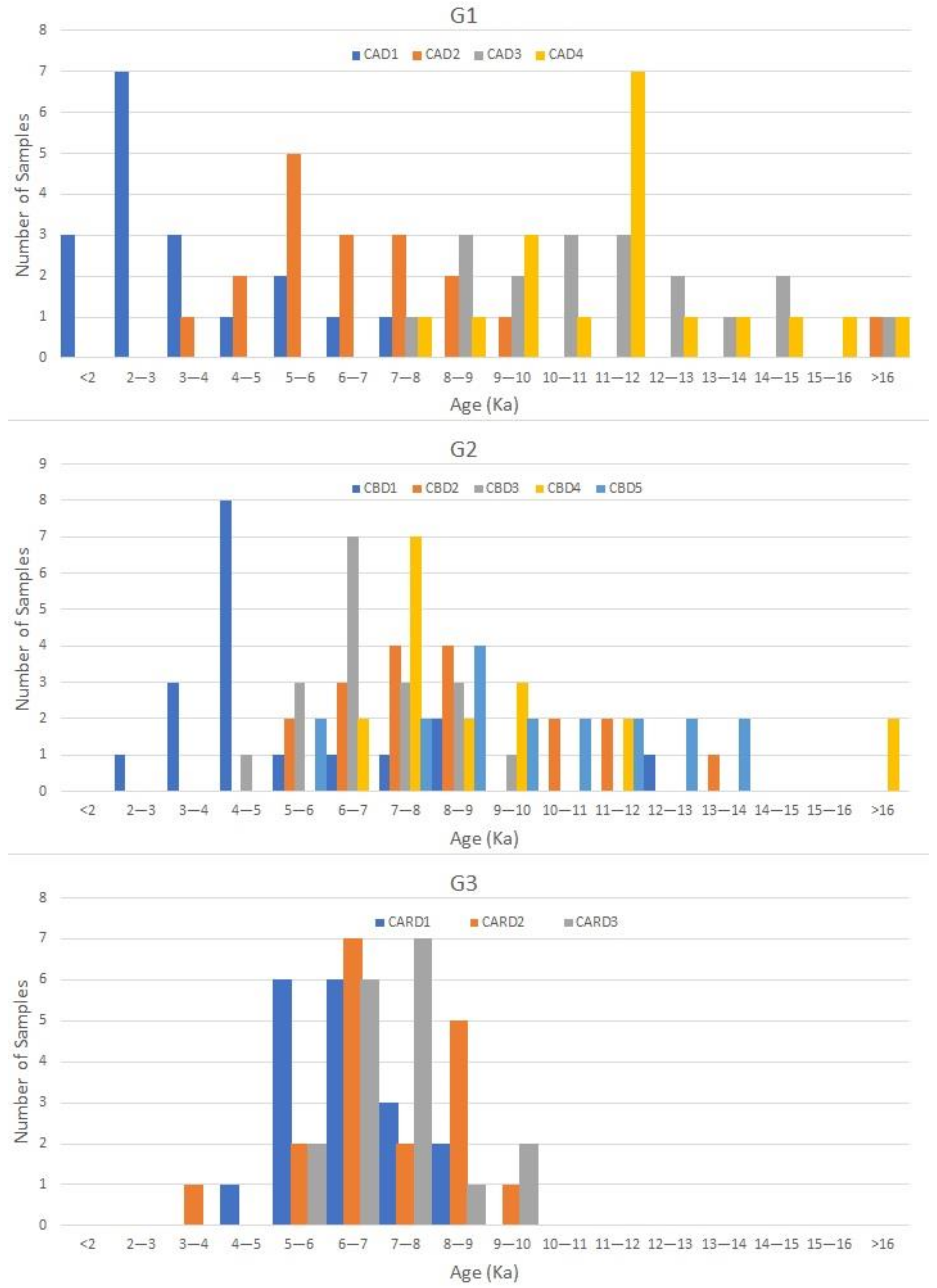
4.3.1. OLS Results
4.3.2. Radioactivity Results
5. Discussion
6. Summary and Conclusions
Author Contributions
Funding
Institutional Review Board Statement
Informed Consent Statement
Acknowledgments
Conflicts of Interest
References
- Walsh, K. (Ed.) Sea-Level Change and Coastal Settlement—Human Engagements with Littoral Environments. In The Archaeology of Mediterranean Landscapes: Human-Environment Interaction from the Neolithic to the Roman Period; Cambridge University Press: Cambridge, UK, 2013; pp. 30–67. [Google Scholar]
- Meulenkamp, J.; Jonkers, A.; Spaak, P.P.; VI Colloquium. Late Miocene to early Pliocene development of Crete. In Proceedings of the VI Colloquium Geology of the Aegean Region, Athens, Greece; 1977; pp. 137–149. [Google Scholar]
- Meulenkamp, J.E.; van der Zwaan, G.J.; van Wamel, W.A. On late miocene to recent vertical motions in the Cretan segment of the Hellenic arc. Tectonophysics 1994, 234, 53–72. [Google Scholar] [CrossRef]
- Angelier, J.; Lybéris, N.; Le Pichon, X.; Barrier, E.; Huchon, P. The tectonic development of the hellenic arc and the sea of crete: A synthesis. Tectonophysics 1982, 86, 159–196. [Google Scholar] [CrossRef]
- Peters, J.M. Neogene and Quaternary Vertical Tectonics in the South Hellenic Arc and Their Effect on Concurrent Sedimentation Processes; Gua: Amsterdam, The Netherlands, 1985; p. 247. [Google Scholar]
- Mourtzas, N. Tectonic Movement of the Coasts of Eastern Crete during the Quaternary. Ph.D. Thesis, Technical University of Athens, Athens, Greece, 1990; 480p. (In Greek). [Google Scholar]
- Kelletat, D. Perspectives in coastal geomorphology of western Crete, Greece. Z. Geomorphol. Suppl. 1996, 102, 1–19. [Google Scholar]
- Peterek, A.; Schwarze, J. Architecture and Late Pliocene to recent evolution of outer-arc basins of the Hellenic subduction zone (south-central Crete, Greece). J. Geodyn. 2004, 38, 19–55. [Google Scholar] [CrossRef]
- Wegmann, K.W. Tectonic Geomorphology above Mediterranean Subduction Zones: Northeastern Apennines of Italy and Crete, Greece; Lehigh University: Bethlehem, PA, USA, 2008. [Google Scholar]
- Tiberti, M.M.; Basili, R.; Vannoli, P. Ups and downs in western Crete (Hellenic subduction zone). Sci. Rep. 2014, 4, 5677. [Google Scholar] [CrossRef] [Green Version]
- Boekschoten, G.J. Some geological observations on the coasts of Crete. Geol. Mijnb. 1963, 42, 241–247. [Google Scholar]
- Hafemann, D. Die Niveauveränderungen an den Küsten Kretas seit dem Altertum; Akad. d. Wiss. ud Literatur; Steiner in Komm.: Wiesbaden, Germany, 1966. [Google Scholar]
- Kelletat, D. Geomorphologische Studien an den Kuesten Kretas. Beitraege zur Regionalen Kuestenmorphologie des Mittelmeerraumes; Vandenhoeck & Ruprecht: Göttingen, German, 1979. [Google Scholar]
- Mourtzas, N.; Kolaiti, E.; Anzidei, M. Vertical land movements and sea level changes along the coast of Crete (Greece) since Late Holocene. Quat. Int. 2016, 401, 43–70. [Google Scholar] [CrossRef]
- Le Pichon, X.; Angelier, J. The Hellenic arc and trench system: A key to the neotectonic evolution of the eastern Mediterranean area. Tectonophysics 1979, 60, 1–42. [Google Scholar] [CrossRef]
- Ten Veen, J.H.; Meijer, P.T. Late Miocene to Recent tectonic evolution of Crete (Greece): Geological observations and model analysis. Tectonophysics 1998, 298, 191–208. [Google Scholar] [CrossRef]
- Fytrolakis, N. The Geological Structure of Crete. Problems, Observations and Conclusions. Habilitation Thesis, National Technical University of Athens, Athens, Greece, 1980; 143p. [Google Scholar]
- Caputo, R.; Catalano, S.; Monaco, C.; Romagnoli, G.; Tortorici, G.; Tortorici, L. Active faulting on the island of Crete (Greece). Geophys. J. Int. 2010, 183, 111–126. [Google Scholar] [CrossRef]
- Caputo, R.; Monaco, C.; Tortorici, L. Multiseismic cycle deformation rates from Holocene normal fault scarps on Crete (Greece). Terra Nova 2006, 18, 181–190. [Google Scholar] [CrossRef]
- Mouslopoulou, V.; Moraetis, D.; Benedetti, L.; Guillou, V.; Bellier, O.; Hristopulos, D. Normal faulting in the forearc of the Hellenic subduction margin: Paleoearthquake history and kinematics of the Spili Fault, Crete, Greece. J. Struct. Geol. 2014, 66, 298–308. [Google Scholar] [CrossRef]
- Flemming, N.C.; Pirazzoli, P.A. Archéologie des côtes de la Crète. Histoire Archéologie Dossiers 1981, 50, 66–81. [Google Scholar]
- McCoy, F.W.; Heiken, G. Tsunami generated by the Late Bronze age eruption of Thera (Santorini), Greece. Pure Appl. Geophys. 2000, 157, 1227–1256. [Google Scholar] [CrossRef]
- Sigurdsson, H.; Carey, S.; Alexandri, M.; Vougioukalakis, G.; Croff, K.; Roman, C.; Sakellariou, D.; Anagnostou, C.; Rousakis, G.; Ioakim, C. Marine investigations of Greece’s Santorini volcanic field. Trans. Am. Geophys. Union 2006, 87, 337–342. [Google Scholar] [CrossRef] [Green Version]
- Bruins, H.J.; MacGillivray, J.A.; Synolakis, C.E.; Benjamini, C.; Keller, J.; Kisch, H.J.; Klügel, A.; Van Der Plicht, J. Geoarchaeological tsunami deposits at Palaikastro (Crete) and the Late Minoan IA eruption of Santorini. J. Archaeol. Sci. 2008, 35, 191–212. [Google Scholar] [CrossRef] [Green Version]
- Flouri, E.T.; Kalligeris, N.; Alexandrakis, G.; Kampanis, N.A.; Synolakis, C.E. Application of a finite difference computational model to the simulation of earthquake generated tsunamis. Appl. Numer. Math. 2013, 67, 111–125. [Google Scholar] [CrossRef]
- Stiros, S.C. The 8.5+ magnitude, AD365 earthquake in Crete: Coastal uplift, topography changes, archaeological and historical signature. Quat. Int. 2010, 216, 54–63. [Google Scholar] [CrossRef]
- Ott, R.F.; Gallen, S.F.; Wegmann, K.W.; Biswas, R.H.; Herman, F.; Willett, S.D. Pleistocene terrace formation, Quaternary rock uplift rates and geodynamics of the Hellenic Subduction Zone revealed from dating of paleoshorelines on Crete, Greece. Earth Planet. Sci. Lett. 2019, 525, 115757. [Google Scholar] [CrossRef]
- Cooper, J.A.G. Beachrock formation in low latitudes: Implications for coastal evolutionary models. Mar. Geol. 1991, 98, 145–154. [Google Scholar] [CrossRef]
- Neumeier, U. Experimental modelling of beachrock cementation under microbial influence. Sediment. Geol. 1999, 126, 35–46. [Google Scholar] [CrossRef]
- Kneale, D.; Viles, H.A. Beach cement: Incipient CaCO3-cemented beachrock development in the upper intertidal zone, North Uist, Scotland. Sediment. Geol. 2000, 132, 165–170. [Google Scholar] [CrossRef]
- Moore, C.H. Intertidal carbonate cementation Grand Cayman, West Indies. J. Sediment. Petrol. 1973, 43, 591–602. [Google Scholar]
- Beier, J.A. Diagenesis of Quaternary Bahamian beachrock: Petrographic and isotopic evidence. J. Sediment. Petrol. 1985, 55, 755–761. [Google Scholar] [CrossRef]
- Chowdhury, S.Q.; Fazlul Haq, A.T.M.; Hasan, K. Beachrock in St. Martin’s Island, Bangladesh: Implication of Sea Level Changes on Beachrock cementation. Mar. Geod. 1997, 20, 89–104. [Google Scholar] [CrossRef]
- Plomaritis, T. Morphology and Geochemistry of the Beachrocks of Sifnos (Greece). Master’s Thesis, University of Southampton, Southampton, UK, 1999. [Google Scholar]
- Holail, H.; Rashed, M. Stable isotopic composition of carbonate-cemented recent beachrock along the Mediterranean and the Red Sea coasts of Egypt. Mar. Geol. 1992, 106, 141–148. [Google Scholar] [CrossRef]
- Tatumi, S.H.; Kowata, E.A.; Gozzi, G.; Kassab, L.R.P.; Suguio, K.; Barreto, A.M.F.; Bezerra, F.H.R. Optical dating results of beachrock, eolic dunes and sediments applied to sea-level changes study. J. Lumin. 2003, 102–103, 562–565. [Google Scholar] [CrossRef]
- Calvet, F.; Cabrera, M.C.; Carracedo, J.C.; Mangas, J.; Perez-Torrado, F.J.; Recio, C.; Trave, A. Beachrocks from the island of La Palma (Canary Islands, Spain). Mar. Geol. 2003, 197, 75–93. [Google Scholar] [CrossRef]
- Font, Y.; Calvet, F. ‘Beachrocks’ Holocenos de la Isla de La Reunion, Oceano Indico. Cuad. Geol. Iber. 1997, 22, 87–102. [Google Scholar]
- Poulos, S.E.; Ghionis, G.; Verykiou, E.; Roussakis, G.; Sakellariou, D.; Karditsa, A.; Alexandrakis, G.; Petrakis, S.; Sifnioti, D.; Panagiotopoulos, I.P.; et al. Hydrodynamic, neotectonic and climatic control of the evolution of a barrier beach in the microtidal environment of the NE Ionian Sea (eastern Mediterranean). Geo Mar. Lett. 2015, 35, 37–52. [Google Scholar] [CrossRef]
- Vousdoukas, M.I.; Velegrakis, A.F.; Plomaritis, T.A. Beachrock occurrence, characteristics, formation mechanisms and impacts. Earth Sci. Rev. 2007, 85, 23–46. [Google Scholar] [CrossRef]
- Hopley, D. Beachrock as a sea-level indicator. In Sea-Level Research: A Manual for the Collection and Evaluation of Data; van der Plassche, O., Ed.; Geo Books: Norwich, UK, 1986; pp. 157–173. [Google Scholar]
- Dermitzakis, M.; Theodoropoulos, D. Study of beach-rocks in the Aegean Sea. Observations on occurrences in SE Crete, Rhodes and Metopi. Ann. Geol. Pays Hell. 1975, 26, 275–305. [Google Scholar]
- Neumeier, U. Le Role de L’Activite Mocrobienne dans la Cementation Precoce des Beachrocks (Sediments Intertidaux). Ph.D. Thesis, University of Geneva, Geneva, Switzerland, 1998. (In French with English Abstract). [Google Scholar]
- Bezerra, F.H.R.; Barreto, A.M.F.; Suguio, K. Holocene sea-level history on the Rio Grande do Norte State coast, Brazil. Mar. Geol. 2003, 196, 73–89. [Google Scholar] [CrossRef]
- Falkenroth, M.; Schneider, B.; Hoffmann, G. Beachrock as sea-level indicator—A case study at the coastline of Oman (Indian Ocean). Quat. Sci. Rev. 2019, 206, 81–98. [Google Scholar] [CrossRef]
- Rovere, A.; Raymo, M.E.; Vacchi, M.; Lorscheid, T.; Stocchi, P.; Gómez-Pujol, L.; Harris, D.L.; Casella, E.; O’Leary, M.J.; Hearty, P.J. The analysis of Last Interglacial (MIS 5e) relative sea-level indicators: Reconstructing sea-level in a warmer world. Earth Sci. Rev. 2016, 159, 404–427. [Google Scholar] [CrossRef] [Green Version]
- Karkani, A.; Evelpidou, N.; Vacchi, M.; Morhange, C.; Tsukamoto, S.; Frechen, M.; Maroukian, H. Tracking shoreline evolution in central Cyclades (Greece) using beachrocks. Mar. Geol. 2017, 388, 25–37. [Google Scholar] [CrossRef]
- Desruelles, S.; Fouache, É.; Ciner, A.; Dalongeville, R.; Pavlopoulos, K.; Kosun, E.; Coquinot, Y.; Potdevin, J.-L. Beachrocks and sea level changes since Middle Holocene: Comparison between the insular group of Mykonos–Delos–Rhenia (Cyclades, Greece) and the southern coast of Turkey. Glob. Planet. Chang. 2009, 66, 19–33. [Google Scholar] [CrossRef]
- Fairbridge, R.W.; Johnson, D.L. Eolianite. In The Encyclopedia of Sedimentology; Fairbridge, R.W., Bourgeois, J., Eds.; Dowden Hutchinson Ross: Stroudsburg, PA, USA, 1978; pp. 279–282. [Google Scholar]
- Bateman, M.D.; Holmes, P.J.; Carr, A.S.; Horton, B.P.; Jaiswal, M.K. Aeolianite and barrier dune construction spanning the last two glacial–interglacial cycles from the southern Cape coast, South Africa. Quat. Sci. Rev. 2004, 23, 1681–1698. [Google Scholar] [CrossRef] [Green Version]
- Jacob, T.; Wahr, J.; Pfeffer, W.T.; Swenson, S. Recent contributions of glaciers and ice caps to sea level rise. Nature 2012, 482, 514–518. [Google Scholar] [CrossRef]
- Mauz, B.; Hijma, M.P.; Amorosi, A.; Porat, N.; Galili, E.; Bloemendal, J. Aeolian beach ridges and their significance for climate and sea level: Concept and insight from the Levant coast (East Mediterranean). Earth Sci. Rev. 2013, 121, 31–54. [Google Scholar] [CrossRef]
- Mauz, B.; Vacchi, M.; Green, A.; Hoffmann, G.; Cooper, A. Beachrock: A tool for reconstructing relative sea level in the far-field. Mar. Geol. 2015, 362, 1–16. [Google Scholar] [CrossRef]
- Hearty, P.J.; Pascal, K. The Stratigraphy and Surficial Geology of New Providence and Surrounding Islands, Bahamas. J. Coast. Res. 1997, 13, 798–812. [Google Scholar]
- Murray-Wallace, C.V.; Bourman, R.P.; Prescott, J.R.; Williams, F.; Price, D.M.; Belperio, A.P. Aminostratigraphy and thermoluminescence dating of coastal aeolianites and the later Quaternary history of a failed delta: The River Murray mouth region, South Australia. Quat. Geochronol. 2010, 5, 28–49. [Google Scholar] [CrossRef]
- Pye, K.; Tsoar, H. Aeolian Sand and Sand Dunes; Springer Science & Business Media: Berlin/Heidelberg, Germany, 2008. [Google Scholar]
- Pye, K.; Tsoar, H. The Formation of Sand Seas and Dune Fields. In Aeolian Sand and Sand Dunes; Springer: Berlin/Heidelberg, Germany, 2009; pp. 141–173. [Google Scholar]
- Andreucci, S.; Clemmensen, L.B.; Murray, A.S.; Pascucci, V. Middle to late Pleistocene coastal deposits of Alghero, northwest Sardinia (Italy): Chronology and evolution. Quat. Int. 2010, 222, 3–16. [Google Scholar] [CrossRef]
- Frechen, M.; Neber, A.; Tsatskin, A.; Boenigk, W.; Ronen, A. Chronology of Pleistocene sedimentary cycles in the Carmel Coastal Plain of Israel. Quat. Int. 2004, 121, 41–52. [Google Scholar] [CrossRef]
- Rodríguez-Vidal, J.; Finlayson, G.; Finlayson, C.; Negro, J.J.; Cáceres, L.M.; Fa, D.A.; Carrión, J.S. Undrowning a lost world—The Marine Isotope Stage 3 landscape of Gibraltar. Geomorphology 2013, 203, 105–114. [Google Scholar] [CrossRef]
- Fornós, J.J.; Clemmensen, L.B.; Gómez-Pujol, L.; Murray, A.S. Late Pleistocene carbonate aeolianites on Mallorca, Western Mediterranean: A luminescence chronology. Quat. Sci. Rev. 2009, 28, 2697–2709. [Google Scholar] [CrossRef]
- Bardají, T.; Goy, J.L.; Zazo, C.; Hillaire-Marcel, C.; Dabrio, C.J.; Cabero, A.; Ghaleb, B.; Silva, P.G.; Lario, J. Sea level and climate changes during OIS 5e in the Western Mediterranean. Geomorphology 2009, 104, 22–37. [Google Scholar] [CrossRef] [Green Version]
- Del Valle Villalonga, L.; Timar-Gabor, A.; Fornós, J.J. Geomorphological Processes and Environmental Interpretation at Espalmador islet (Western Mediterranean). J. Mar. Sci. Eng. 2019, 7, 144. [Google Scholar] [CrossRef] [Green Version]
- Vacher, H.; Hearty, P.; Rowe, M.; Curran, H.; White, B. Stratigraphy of Bermuda: Nomenclature, concepts, and status of multiple systems of classification. Spec. Pap. Geol. Soc. Am. 1995, 300, 271–294. [Google Scholar]
- Boekschoten, G.J. Beachrock at Limani Chersonisos, Crete. Geol. Mijnb. 1962, 41, 3–7. [Google Scholar]
- Gaki-Papanastassiou, K.; Karymbalis, E.; Papanastassiou, D.; Maroukian, H. Quaternary marine terraces as indicators of neotectonic activity of the Ierapetra normal fault SE Crete (Greece). Geomorphology 2009, 104, 38–46. [Google Scholar] [CrossRef]
- Dermitzakis, M.; Michail, C.; Mpasiakos, G.; Tripolitsioutou, F. Contricution to the absolute dating of beachrock by the means of the Thermoluminescence technique. In Proceedings of the 4th National Symposium on Oceanography and Fisheries, Rhodes Island, Greece, 26–29 April 1993; pp. 259–267, (In Greek with English Abstract). [Google Scholar]
- Kelletat, D. Zonality of Modern Coastal Processes and Sea-Level Indicators. Palaeogeogr. Palaeoclimatol. Palaeoecol. 1988, 68, 219–230. [Google Scholar] [CrossRef]
- Mourtzas, N.D. Fish tanks of eastern Crete (Greece) as indicators of the Roman sea level. J. Archaeol. Sci. 2012, 39, 2392–2408. [Google Scholar] [CrossRef]
- Alexandrakis, G.; Karditsa, A.; Poulos, S.; Ghionis, G.; Kampanis, N. An assessment of the vulnerability to erosion of the coastal zone due to a potential rise of sea level: The case of the Hellenic Aegean coast. In Εncyclopedia of Life Support Systems (EOLSS). Developed under the Auspices of the UNESCO; Sydow, A., Ed.; Eolss Publishers: Oxford, UK, 2010; Volume 1. [Google Scholar]
- Alexandrakis, G.; Ghionis, G.; Poulos, S.E.; Kampanis, N.A. Greece. In Coastal Erosion and Protection in Europe; Pranzini, E., Williams, A., Eds.; Routledge: London, UK, 2013; p. 355. [Google Scholar]
- Alexandrakis, G.; Poulos, S.Ε. An holistic approach to beach erosion vulnerability assessment. Sci. Rep. 2014, 4, 6078. [Google Scholar] [CrossRef] [Green Version]
- Hatzidakis, I. Minoikoi tafoi stin Kriti (in Greek). Archaiologikon Delt. 1918, 4, 45–87. [Google Scholar]
- Evans, A.J. The Palace of Minos at Knossos; Macmillan: London, UK, 1928; Volume 2, 232p. [Google Scholar]
- Hadzi-Vallianos, D. Prefecture of Heraklion, Gazi—Ammoudara. Archaiologikon Delt. 1979, 34, 384–385. [Google Scholar]
- Athanasaki, K. A coastal Neopalatial settlement in Ammoudara Heraklion: A preliminary approach. In Archaeological Work in Crete, Proceedings of the Third Meeting; University of Crete: Rethymnon, Greece, 2015; pp. 271–280. [Google Scholar]
- Murray, A.S.; Clemmensen, L.B. Luminescence dating of Holocene aeolian sand movement, Thy, Denmark. Quat. Sci. Rev. 2001, 20, 751–754. [Google Scholar] [CrossRef]
- Banerjee, D.; Murray, A.S.; Botter-Jensen, L.; Lang, A. Equivalent dose estimation using a single aliquot of polymineral fine grains. Radiat. Meas. 2001, 33, 73–94. [Google Scholar] [CrossRef]
- Roberts, R.G.; Galbraith, R.; Yoshida, H.; Laslett, G.; Olley, J.M. Distinguishing dose populations in sediment mixtures: A test of single-grain optical dating procedures using mixtures of laboratory-dosed quartz. Radiat. Meas. 2000, 32, 459–465. [Google Scholar] [CrossRef]
- Kitis, G.; Polymeris, G.; Pagonis, V.; Tsirliganis, N. Anomalous fading of OSL signals originating from very deep traps in Durango apatite. Radiat. Meas. 2013, 49, 73–81. [Google Scholar] [CrossRef]
- Duller, G.A.T. Recent developments in luminescence dating of Quaternary sediments. Prog. Phys. Geogr. Earth Environ. 1996, 20, 127–145. [Google Scholar] [CrossRef]
- Jain, C.; Singhal, D.; Sharma, M. Adsorption of zinc on bed sediment of River Hindon: Adsorption models and kinetics. J. Hazard. Mater. 2004, 114, 231–239. [Google Scholar] [CrossRef] [PubMed]
- Porat, N.; Amit, R.; Enzel, Y.; Zilberman, E.; Avni, Y.; Ginat, H.; Gluck, D. Abandonment ages of alluvial landforms in the hyperarid Negev determined by luminescence dating. J. Arid Environ. 2010, 74, 861–869. [Google Scholar] [CrossRef]
- Bowman, D.; Korjenkov, A.; Porat, N. Late-Pleistocene seismites from Lake Issyk-Kul, the tien shan range, Kyrghyzstan. Sediment. Geol. 2004, 163, 211–228. [Google Scholar] [CrossRef]
- Choi, J.H.; Murray, A.S.; Cheong, C.S.; Hong, D.G.; Chang, H.W. The resolution of stratigraphic inconsistency in the luminescence ages of marine terrace sediments from Korea. Quat. Sci. Rev. 2003, 22, 1201–1206. [Google Scholar] [CrossRef]
- Huntley, D.J.; Godfrey-Smith, D.I.; Thewalt, M.L.W. Optical dating of sediments. Nature 1985, 313, 105–107. [Google Scholar] [CrossRef]
- Jacob, J.; Gama, C.; Salgado, R.; Liu, J.T.; Silva, A. Shadowing Effects on Beach Morphodynamics during Storm Events on Tróia-Sines Embayed Coast, Southwest Portugal. J. Coast. Res. 2009, 73–77. [Google Scholar] [CrossRef]
- Madsen, A.T.; Murray, A.S. Optically stimulated luminescence dating of young sediments: A review. Geomorphology 2009, 109, 3–16. [Google Scholar] [CrossRef]
- Tsakalos, E.; Athanassas, C.; Tsipas, P.; Triantaphyllou, M.; Geraga, M.; Papatheodorou, G.; Filippaki, E.; Christodoulakis, J.; Kazantzaki, M. Luminescence geochronology and paleoenvironmental implications of coastal deposits of southeast Cyprus. Archaeol. Anthropol. Sci. 2018, 10, 41–60. [Google Scholar] [CrossRef]
- Nian, X.M.; Zhang, W.G.; Qiu, F.Y.; Qin, J.T.; Wang, Z.H.; Sun, Q.L.; Chen, J.; Chen, Z.Y.; Liu, N.K. Luminescence characteristics of quartz from Holocene delta deposits of the Yangtze River and their provenance implications. Quat. Geochronol. 2019, 49, 131–137. [Google Scholar] [CrossRef]
- Roberts, R.; Bird, M.; Olley, J.; Galbraith, R.; Lawson, E.; Laslett, G.; Yoshida, H.; Jones, R.; Fullagar, R.; Jacobsen, G.; et al. Optical and radiocarbon dating at Jinmium rock shelter in northern Australia. Nature 1998, 393, 358–362. [Google Scholar] [CrossRef]
- Bristow, C.S.; Duller, G.A.T.; Lancaster, N. Age and dynamics of linear dunes in the Namib Desert. Geology 2007, 35, 555–558. [Google Scholar] [CrossRef]
- Costas, S.; Ferreira, O.; Plomaritis, T.A.; Leorri, E. Coastal barrier stratigraphy for Holocene high-resolution sea-level reconstruction. Sci. Rep. 2016, 6, 38726. [Google Scholar] [CrossRef] [Green Version]
- Tamura, T.; Oliver, T.S.N.; Cunningham, A.C.; Woodroffe, C.D. Recurrence of Extreme Coastal Erosion in SE Australia beyond Historical Timescales Inferred from Beach Ridge Morphostratigraphy. Geophys. Res. Lett. 2019, 46, 4705–4714. [Google Scholar] [CrossRef] [Green Version]
- Wang, F.; Zhang, W.G.; Nian, X.M.; Ge, C.; Zhao, X.Q.; Cheng, Q.Z.; Chen, J.; Hutchinson, S.M. Refining the late-Holocene coastline and delta development of the northern Yangtze River delta: Combining historical archives and OSL dating. Holocene 2019, 29, 1439–1449. [Google Scholar] [CrossRef]
- Fassoulas, C. The tectonic development of a Neogene basin at the leading edge of the active European margin: The Heraklion basin, Crete, Greece. J. Geodyn. 2001, 31, 49–70. [Google Scholar] [CrossRef]
- Tsimplis, M.N. Tidal oscillations in the Aegean and Ionian Seas. Estuar. Coast. Shelf Sci. 1994, 39, 201–208. [Google Scholar] [CrossRef]
- Soukissian, T.; Hatzinaki, M.; Korres, G.; Papadopoulos, A.; Kallos, G.; Anadranistakis, E. Wind and Wave Atlas of the Hellenic Seas; Hellenic Centre for Marine Research Publ.: Athens, Greece, 2007. [Google Scholar]
- Alexandrakis, G.; Ghionis, G.; Poulos, S. The Effect of Beach Rock Formation on the Morphological Evolution of a Beach. The Case Study of an Eastern Mediterranean Beach: Ammoudara, Greece. J. Coast. Res. 2013, 69 (Suppl. 1), 47–59. [Google Scholar] [CrossRef]
- Folk, R.L. Petrology of the Sedimentary Rocks; Hemphill Publishing Company: Austin, TX, USA, 1980; 182p. [Google Scholar]
- Murray, A.S.; Wintle, A.G. Luminescence dating of quartz using an improved single-aliquot regenerative-dose protocol. Radiat. Meas. 2000, 32, 57–73. [Google Scholar] [CrossRef]
- Aitken, M.J. Thermoluminescence Dating; Academic Press: London, UK, 1985. [Google Scholar]
- Himmelstoss, E.A.; Henderson, R.E.; Kratzmann, M.G.; Farris, A.S. Digital Shoreline Analysis System (DSAS) Version 5.0 User Guide; Open-File Report 2018–1179; U.S. Geological Survey: Reston, VA, USA, 2018. [Google Scholar]
- Alexandrakis, G.; Athanasaki, K.; Kampanis, N. Towards a GIS reconstruction of the Ammoudara coastal landscape, integrating archaeological evidence and geomorphological data. In Proceedings of the 2nd Conference on Computer Applications and Quantitative Methods in Archaeology Greek Chapter, Athens, Greece, 22–23 December 2016; pp. 45–50. [Google Scholar]
- Pareschi, M.T.; Favalli, M.; Boschi, E. Impact of the Minoan tsunami of Santorini: Simulated scenarios in the eastern Mediterranean. Geophys. Res. Lett. 2006, 33, L18607. [Google Scholar] [CrossRef]
- Ashmore, W. Social archaeologies of landscape. In A Companion to Social Archaeology; Blackwell Publishing Ltd.: Hoboken, NJ, USA, 2004; pp. 255–271. [Google Scholar]
- Solomon, S. Climate Change 2007: The Physical Science Basis: Contribution of Working Group I to the Fourth Assessment Report of the Intergovernmental Panel On Climate Change. Cambridge University Press: Cambridge, UK, 2007; 987p. [Google Scholar]
- Papazachos, V. The Earthquakes of Greece; Editions Ziti: Thessaloniki, Greece, 1997. [Google Scholar]
- Di Vita, A. Archaeologists and earthquakes: The case of 365 A.D. Ann. Geophys. 1995, 38, 5–6. [Google Scholar]
- Di Vita, A. Earthquakes and civil life at Gortyn (Crete) in the period between Justinian and Constant II (6–7th century AD). Archaeoseismology 1996, 7, 45–50. [Google Scholar]
- Spyropoulos, P.J.A.D. Chronicle of the Earthquakes of Greece from Antiquity until Today; Ziti Publications: Thessaloniki, Greece, 1997. [Google Scholar]
- Ambraseys, N. Earthquakes in the Mediterranean and Middle East: A Multidisciplinary Study of Seismicity up to 1900; Cambridge University Press: Cambridge, UK, 2009. [Google Scholar]
- Papadopoulos, G. A Seismic History of Crete; Ocelotos Publications: Athens, Greece, 2011; Volume 65. [Google Scholar]
- Guidoboni, E.; Comastri, A. The large earthquake of 8 August 1303 in Crete: Seismic scenario and tsunami in the Mediterranean area. J. Seismol. 1997, 1, 55–72. [Google Scholar] [CrossRef]
- Pirazzoli, P.; Evelpidou, N. Tidal notches: A sea-level indicator of uncertain archival trustworthiness. Palaeogeogr. Palaeoclimatol. Palaeoecol. 2013, 369, 377–384. [Google Scholar] [CrossRef]
- Auriemma, R.; Solinas, E. Archaeological remains as sea level change markers: A review. Quat. Int. 2009, 206, 134–146. [Google Scholar] [CrossRef]
- Scicchitano, G.; Lo Presti, V.; Spampinato, C.; Gasparo Morticelli, M.; Antonioli, F.; Auriemma, R.; Ferranti, L.; Monaco, C. Millstones as indicators of relative sea-level changes in northern Sicily and southern Calabria coastlines, Italy. Quat. Int. 2011, 232, 92–104. [Google Scholar] [CrossRef] [Green Version]
- Leatham, J.; Hood, S. Sub-Marine Exploration in Crete, 1955. Annu. Br. Sch. Athens 1959, 53, 263–280. [Google Scholar] [CrossRef]
- Epting, M. Geologie der östlichen Talea Ori, Kreta. Diploma Thesis, The University of Freiburg, Freiburg im Breisgau, Germany, 1969. [Google Scholar]
- Shaw, J.W. Minoan Architecture: Materials and Techniques; Bottega d’Erasmo Università di Catania, Centro di Archeologia Cretese: Catania, Italy, 2009. [Google Scholar]
- Guest-Papamanoli, A. Les carrières de grès dunaire à Malia. Bull. Corresp. Hell. 1989, 113, 113–122. [Google Scholar] [CrossRef]
- Mouslopoulou, V.; Begg, J.; Nicol, A.; Oncken, O.; Prior, C. Formation of Late Quaternary paleoshorelines in Crete, Eastern Mediterranean. Earth Planet. Sci. Lett. 2015, 431, 294–307. [Google Scholar] [CrossRef]
- Tian, S.; Sun, J.; Lü, L.; Cao, M.; Zhang, Z.; Lü, T. Optically stimulated luminescence dating of late Quaternary loess deposits in the coastal region of North China: Provenance and paleoclimatic implications. Quat. Sci. Rev. 2019, 218, 160–177. [Google Scholar] [CrossRef]
- Lima, K.C.; Perez Filho, A. Evolução Geomorfológica de Planícies Costeiras no Holoceno. Mercator (Fortaleza) 2020, 19, e19010. [Google Scholar] [CrossRef]
- Mattei, G.; Aucelli, P.P.C.; Caporizzo, C.; Rizzo, A.; Pappone, G. New Geomorphological and Historical Elements on Morpho-Evolutive Trends and Relative Sea-Level Changes of Naples Coast in the Last 6000 Years. Water 2020, 12, 2651. [Google Scholar] [CrossRef]
- Bueno, L.; Feathers, J.; Blasis, P. The formation process of a paleoindian open-air site in Central Brazil: Integrating lithic analysis, radiocarbon and luminescence dating. J. Archaeol. Sci. 2013, 40, 190–203. [Google Scholar] [CrossRef]
- Sommerville, A.A.; Hansom, J.D.; Housley, R.A.; Sanderson, D.C.W. Optically stimulated luminescence (OSL) dating of coastal aeolian sand accumulation in Sanday, Orkney Islands, Scotland. Holocene 2016, 17, 627–637. [Google Scholar] [CrossRef]
- Sommerville, A.A.; Hansom, J.; Sanderson, D.C.W.; Housley, R. Optically stimulated luminescence dating of large storm events in Northern Scotland. Quat. Sci. Rev. 2003, 22, 1085–1092. [Google Scholar] [CrossRef]
- Bateman, M.D.; Boulter, C.H.; Carr, A.; Frederick, C.; Peter, D.; Wilder, M. Preserving the palaeoenvironmental record in Drylands: Bioturbation and its significance for luminescence-derived chronologies. Sediment. Geol. 2007, 195, 5–19. [Google Scholar] [CrossRef] [Green Version]
- Schokker, J.; Cleveringa, P.; Murray, A. Palaeoenvironmental reconstruction and OSL dating of terrestrial Eemian deposits in the southeastern Netherlands. J. Quat. Sci. 2004, 19, 193–202. [Google Scholar] [CrossRef]
- Dörschner, N.; Reimann, T.; Wenske, D.; Lüthgens, C.; Tsukamoto, S.; Frechen, M.; Böse, M. Reconstruction of the Holocene coastal development at Fulong Beach in north-eastern Taiwan using optically stimulated luminescence (OSL) dating. Quat. Int. 2012, 263, 3–13. [Google Scholar] [CrossRef]
- Shtienberg, G.; Dix, J.K.; Roskin, J.; Waldmann, N.; Bookman, R.; Bialik, O.M.; Porat, N.; Taha, N.; Sivan, D. New perspectives on coastal landscape reconstruction during the Late Quaternary: A test case from central Israel. Palaeogeogr. Palaeoclimatol. Palaeoecol. 2017, 468, 503–519. [Google Scholar] [CrossRef]
- Dalrymple, R.A.; Kirby, J.T.; Hwang, P.A. Wave diffraction due to areas of energy dissipation. J. Waterw. Port Coast. Ocean Eng. 1984, 110, 67–79. [Google Scholar] [CrossRef]


| Date | Type | Scale | Pixel Size | Source |
|---|---|---|---|---|
| 17/09/1945 | Aerial photo | 1:42,000 | 3 m | HMGS |
| 1968 | Aerial photo | 1:15,000 | 1 m | HMGS |
| 23/07/1998 | Aerial photo | 1:10,000 | 1 m | HMGS |
| 2005 | Orthophoto | 1:15,000 | 0.6 m | Ktimatologio S.A. |
| 14/06/2009 | Satellite image | - | 0.5 m | Google Earth (maxar technologies) |
| 20/06/2010 | Aerial photo | 1:30,000 | 1.5 m | HMGS |
| 2011 | Orthophoto | 1:15,000 | 0.6 m | Ktimatologio S.A. |
| 06/11/2012 | Satellite image | - | 0.2 m | Google Earth (maxar technologies) |
| 29/04/2013 | Satellite image | - | 0.5 m | Google Earth |
| 27/06/2016 | Satellite image | - | 0.2 m | Google Earth (CNES/Airbus) |
| 28/06/2017 | Satellite image | - | 0.3 m | Google Earth |
| 24/03/2019 | Satellite image | - | 0.2 m | Google Earth (CNES/Airbus) |
| Transects | 1945–1998 | 1998–2002 | 2002–2009 | 2009–2015 | 2015–2020 | 1945–2020 |
|---|---|---|---|---|---|---|
| 20 | 0.0 | −1.9 | 3.4 | −3.3 | −4 | −3.4 |
| 37 | −17.8 | −11.0 | 3.6 | 14.7 | −12.4 | −23.1 |
| 50 | −33.0 | −15.8 | 15.2 | −7.3 | −0.6 | −41.4 |
| 75 | −40.9 | −8.7 | 0.6 | −0.3 | −4.7 | −53.9 |
| 90 | −49.2 | −10.2 | 3.3 | −2.9 | 3.3 | −55.6 |
| 110 | −53.7 | −7.2 | 2.6 | −3.5 | 11.2 | −50.5 |
| 125 | −42.4 | −7.4 | −2.5 | −3.9 | 9.8 | −31.45 |
| No | Lat | Lon | Altitude | Distance from the Coastline | Depth |
|---|---|---|---|---|---|
| G1 | 35°20′15.62″ N | 25°6′7.79″ E | 2.45 m | 67.5 m | 10 m |
| G2 | 35°20′14.73″ N | 25°4′53.74″ E | 2.33 m | 55 m | 10 m |
| G2′ | 35°20′14.40″ N | 25°04′53.57″ E | 2.37 m | 51 m | 8 m |
| G3 | 35°20′22.75″ N | 25°3′33.88″ E | 2,62 m | 76.6 m | 10 m |
| G1 | G2 | G3 | |||||||||||
|---|---|---|---|---|---|---|---|---|---|---|---|---|---|
| Sample Code | G1CA D1 | G1CAD2 | G1CAD3 | G1CA D4 | G2CBD1 | G2CBD2 | G2CBD3 | G2CBD4 | G2CB D5 | G3CARD1 | G3CARD2 | G3CARD3 | |
| Equivalent Dose (Gy) | Mean ± 1sd (N = 18) | 3.4 ± 1.8 | 9.2 ± 3.9 | 9.9 ± 2.7 | 10.4 ± 3.3 | 3.7 ± 1.6 | 6.5 ± 1.7 | 5.6 ± 1.1 | 7.0 ± 2.3 | 6.9 ± 1.8 | 5.2 ± 1.7 | 8.0 ± 3.9 | 6.3 ± 1.0 |
| Sample Code | Recycling Ratio | Recuperation (%) | Dose Recovery Ratio | |
|---|---|---|---|---|
| G1 | G1CAD1 | 1.06 ± 0.09 | 3.89 ± 3.29 | 0.93 ± 0.17 |
| G1CAD2 | 1.04 ± 0.10 | 2.18 ± 1.58 | 0.96 ± 0.13 | |
| G1CAD3 | 1.02 ± 0.25 | 6.97 ± 6.02 | 0.91 ± 0.21 | |
| G1CAD4 | 0.98 ± 0.13 | 2.15 ± 2.44 | 0.98 ± 0.19 | |
| G2 | G2CBD1 | 1.08 ± 0.09 | 5.24 ± 5.88 | 0.92 ± 0.15 |
| G2CBD2 | 1.11 ± 0.11 | 1.54 ± 3.35 | 0.94 ± 0.24 | |
| G2CBD3 | 1.08 ± 0.10 | 3.08 ± 2.72 | 0.97 ± 0.17 | |
| G2CBD4 | 1.01 ± 0.14 | 0.67 ± 2.97 | 0.91 ± 0.13 | |
| G2CBD5 | 1.01 ± 0.14 | 2.88 ± 5.41 | 0.95 ± 0.19 | |
| G3 | G3CARD1 | 1.06 ± 0.05 | 2.76 ± 2.27 | 0.95 ± 0.14 |
| G3CARD2 | 1.02 ± 0.10 | 2.12 ± 2.00 | 0.93 ± 0.11 | |
| G3CARD3 | 1.04 ± 0.05 | 2.92 ± 1.68 | 0.98 ± 0.19 |
| Isotope | 238U | 235U | 232TH | 40K | 87RB | Total | ||
|---|---|---|---|---|---|---|---|---|
| G1 | G1CAD1 | Radioactivity (Bq/kg) | 17.5 ± 1 | 1.52 ± 0.59 | 11.9 ± 0.9 | 185.9 ± 7.9 | ||
| Dose rate (Gy/ka) | 0.337 ± 0.022 | 0.012 ± 0.005 | 0.175 ± 0.013 | 0.494 ± 0.021 | 0.019 | 1.037 ± 0.033 | ||
| G1CAD2 | Radioactivity (Bq/kg) | 18.4 ± 1.1 | 0.87 ± 0.63 | 15.7 ± 1 | 232.1 ± 8.5 | |||
| Dose rate (Gy/ka) | 0.341 ± 0.022 | 0.007 ± 0.005 | 0.25 ± 0.016 | 0.668 ± 0.025 | 0.019 | 1.285 ± 0.037 | ||
| G1CAD3 | Radioactivity (Bq/kg) | 14 ± 0.8 | 0.91 ± 0.44 | 9.3 ± 0.7 | 141.8 ± 5.9 | |||
| Dose rate (Gy/ka) | 0.274 ± 0.018 | 0.008 ± 0.004 | 0.148 ± 0.011 | 0.41 ± 0.017 | 0.019 | 0.860 ± 0.027 | ||
| G1CAD4 | Radioactivity (Bq/kg) | 14.6 ± 0.9 | 0.66 ± 0.33 | 9.4 ± 0.7 | 133.8 ± 6.9 | |||
| Dose rate (Gy/ka) | 0.283 ± 0.019 | 0.006 ± 0.003 | 0.156 ± 0.012 | 0.402 ± 0.021 | 0.019 | 0.866 ± 0.031 | ||
| G2 | G2CBD1 | Radioactivity (Bq/kg) | 12.8 ± 0.7 | 0.97 ± 0.36 | 6.8 ± 0.5 | 104.9 ± 4.5 | ||
| Dose rate (Gy/ka) | 0.244 ± 0.015 | 0.008 ± 0.003 | 0.106 ± 0.008 | 0.297 ± 0.013 | 0.019 | 0.675 ± 0.021 | ||
| G2CBD2 | Radioactivity (Bq/kg) | 13.8 ± 0.8 | 1.17 ± 0.51 | 7.8 ± 0.6 | 117.9 ± 6.6 | |||
| Dose rate (Gy/ka) | 0.272 ± 0.018 | 0.01 ± 0.004 | 0.127 ± 0.01 | 0.344 ± 0.019 | 0.019 | 0.771 ± 0.028 | ||
| G2CBD3 | Radioactivity (Bq/kg) | 9.9 ± 0.7 | 0.37 ± 0.29 | 8.9 ± 0.6 | 168.1 ± 11.2 | |||
| Dose rate (Gy/ka) | 0.176 ± 0.013 | 0.003 ± 0.002 | 0.14 ± 0.01 | 0.477 ± 0.032 | 0.019 | 0.815 ± 0.036 | ||
| G2CBD4 | Radioactivity (Bq/kg) | 11.3 ± 0.7 | 0.36 ± 0.3 | 8 ± 0.6 | 146.9 ± 6.6 | |||
| Dose rate (Gy/ka) | 0.212 ±0.015 | 0.003 ± 0.002 | 0.125 ± 0.01 | 0.413 ± 0.019 | 0.019 | 0.772 ± 0.026 | ||
| G2CBD5 | Radioactivity (Bq/kg) | 11 ± 0.7 | 0.41 ± 0.29 | 8.1 ± 0.6 | 148.6 ± 16.1 | |||
| Dose rate (Gy/ka) | 0.189 ± 0.014 | 0.003 ± 0.002 | 0.117 ± 0.009 | 0.389 ± 0.042 | 0.019 | 0.717 ± 0.045 | ||
| G3 | G3CARD1 | Radioactivity (Bq/kg) | 16.6 ± 0.9 | 1.07 ± 0.56 | 8 ± 0.6 | 136.8 ± 6.7 | ||
| Dose rate (Gy/ka) | 0.243 ± 0.016 | 0.008 ± 0.004 | 0.114 ± 0.009 | 0.355 ± 0.017 | 0.019 | 0.739 ± 0.026 | ||
| G3CARD2 | Radioactivity (Bq/kg) | 16.7 ± 0.9 | 0.84 ± 0.42 | 11.3 ± 0.8 | 190.7 ± 7.2 | |||
| Dose rate (Gy/ka) | 0.301 ± 0.019 | 0.007 ± 0.004 | 0.181 ± 0.012 | 0.55 ± 0.021 | 0.019 | 1.058 ± 0.031 | ||
| G3CARD3 | Radioactivity (Bq/kg) | 13.2 ± 0.8 | 0.68 ± 0.46 | 9.3 ± 0.7 | 155.7 ± 6.4 | |||
| Dose rate (Gy/ka) | 0.255 ± 0.017 | 0.006 ± 0.004 | 0.151 ± 0.011 | 0.457 ± 0.019 | 0.019 | 0.887 ± 0.028 | ||
| Sample Code | Equivalent Dose (GY) | Dose Rates (GY/KA) | Ages (Y) | Min–Max (Y) | Moisture (%) | |
|---|---|---|---|---|---|---|
| G1 | G1CAD1 | 3.4 ± 1.8 | 1.037 ± 0.033 | 3300 ± 1750 | 1500–7400 | 21.280 |
| G1CAD2 | 9.2 ± 3.9 | 1.285 ± 0.037 | 7150 ± 3050 | 3600–17,550 | 13.120 | |
| G1CAD3 | 9.9 ± 2.7 | 0.860 ± 0.027 | 11,500 ± 3150 | 7800–21,000 | 12.523 | |
| G1CAD4 | 10.4 ± 3.3 | 0.866 ± 0.031 | 12,050 ± 3800 | 7900–25,300 | 8.893 | |
| G2 | G2CBD1 | 3.7 ± 1.6 | 0.675 ± 0.021 | 5500 ± 2400 | 2400–12,900 | 14.591 |
| G2CBD2 | 5.6 ± 1.1 | 0.815 ± 0.036 | 6850 ± 1300 | 4450–9500 | 14.519 | |
| G2CBD3 | 6.5 ± 1.7 | 0.771 ± 0.028 | 8450 ± 2150 | 5300–13,050 | 11.732 | |
| G2CBD4 | 7.0 ± 2.3 | 0.772 ± 0.026 | 9100 ± 2950 | 6150–16,450 | 15.477 | |
| G2CBD5 | 6.9 ± 1.8 | 0.717 ± 0.045 | 9650 ± 2500 | 5250–13,850 | 22.991 | |
| G3 | G3CARD1 | 5.2 ± 1.7 | 0.739 ± 0.026 | 6550 ± 1100 | 4850–8800 | 23.923 |
| G3CARD2 | 8.0 ± 3.9 | 1.058 ± 0.031 | 6900 ± 1350 | 3800–9400 | 12.839 | |
| G3CARD3 | 6.3 ± 1.0 | 0.887 ± 0.028 | 7150 ± 1150 | 5600–9500 | 11.221 |
| OSL | G1 | G2 | G3 | ||||||||||
|---|---|---|---|---|---|---|---|---|---|---|---|---|---|
| Age (Y)N | CAD1 | CAD2 | CAD3 | CAD4 | CBD1 | CBD2 | CBD3 | CBD4 | CBD5 | CARD1 | CARD2 | CARD3 | |
| 1 | 1511 | 3604 | 7781 | 7892 | 2377 | 5313 | 4447 | 6170 | 5246 | 4854 | 3808 | 5586 | |
| 2 | 1551 | 4862 | 8010 | 8666 | 3505 | 5671 | 5070 | 6702 | 5632 | 5416 | 5251 | 5638 | |
| 3 | 1796 | 4886 | 8506 | 9271 | 3842 | 6728 | 5816 | 7009 | 7083 | 5457 | 5681 | 6080 | |
| 4 | 2072 | 5014 | 8775 | 9345 | 4000 | 6873 | 5939 | 7054 | 7547 | 5675 | 6153 | 6153 | |
| 5 | 2167 | 5671 | 9312 | 9980 | 4114 | 6878 | 6258 | 7064 | 8322 | 5757 | 6176 | 6205 | |
| 6 | 2192 | 5738 | 9913 | 10,644 | 4340 | 7102 | 6355 | 7123 | 8659 | 5776 | 6309 | 6217 | |
| 7 | 2195 | 5830 | 10,219 | 11,085 | 4495 | 7107 | 6362 | 7618 | 8762 | 5982 | 6361 | 6333 | |
| 8 | 2211 | 5888 | 10,344 | 11,101 | 4527 | 7461 | 6433 | 7878 | 8960 | 6098 | 6406 | 6630 | |
| 9 | 2373 | 6316 | 10,969 | 11,250 | 4562 | 7901 | 6443 | 7948 | 9083 | 6237 | 6506 | 7023 | |
| 10 | 2709 | 6647 | 11,319 | 11,336 | 4637 | 8065 | 6446 | 8282 | 9265 | 6694 | 6855 | 7273 | |
| 11 | 3069 | 6943 | 11,440 | 11,367 | 4933 | 8493 | 6816 | 8969 | 10,100 | 6710 | 7002 | 7456 | |
| 12 | 3397 | 7233 | 11,463 | 11,979 | 4988 | 8612 | 7071 | 9009 | 10,264 | 6765 | 7123 | 7487 | |
| 13 | 3689 | 7260 | 12,293 | 11,998 | 5749 | 8831 | 7082 | 9113 | 11,037 | 6891 | 8080 | 7775 | |
| 14 | 4144 | 7854 | 12,718 | 12,655 | 6670 | 10,016 | 7286 | 9284 | 11,380 | 7194 | 8247 | 7825 | |
| 15 | 5191 | 8376 | 13,543 | 13,949 | 7180 | 10,232 | 8410 | 11,092 | 12,131 | 7789 | 8319 | 7965 | |
| 16 | 5202 | 8832 | 14,363 | 14,390 | 8048 | 11,706 | 8478 | 11,095 | 12,743 | 7792 | 8392 | 8266 | |
| 17 | 6410 | 9786 | 14,877 | 15,033 | 8203 | 11,899 | 8878 | 16,066 | 13,644 | 8281 | 8448 | 9137 | |
| 18 | 7425 | 17,558 | 20,977 | 25,282 | 12,904 | 13,062 | 9492 | 16,427 | 13,835 | 8799 | 9401 | 9516 | |
| Sample Code | 18 | 12 | ||
|---|---|---|---|---|
| G1 | G1CAD1 | Average ± 1sd (y) | 3300 ± 1750 | 2950 ± 1000 |
| Relative error (%) | 53.0 | 33.9 | ||
| G1CAD2 | Average ± 1sd (y) | 7150 ± 3050 | 6550 ± 1000 | |
| Relative error (%) | 42.7 | 15.3 | ||
| G1CAD3 | Average ± 1sd (y) | 11,500 ± 3150 | 11,050 ± 1400 | |
| Relative error (%) | 27.4 | 12.7 | ||
| G1CAD4 | Average ± 1sd (y) | 12,050 ± 3800 | 11,400 ± 1200 | |
| Relative error (%) | 31.5 | 10.5 | ||
| G2 | G2CBD1 | Average ± 1sd (y) | 5500 ± 2400 | 5000 ± 1000 |
| Relative error (%) | 43.6 | 20.0 | ||
| G2CBD2 | Average ± 1sd (y) | 6850 ± 1300 | 6750 ± 650 | |
| Relative error (%) | 19.0 | 9.6 | ||
| G2CBD3 | Average ± 1sd (y) | 8450 ± 2150 | 8150 ± 1150 | |
| Relative error (%) | 25.4 | 14.1 | ||
| G2CBD4 | Average ± 1sd (y) | 9100 ± 2950 | 8350 ± 1200 | |
| Relative error (%) | 32.4 | 14.4 | ||
| G2CBD5 | Average ± 1sd (y) | 9650 ± 2500 | 9650 ± 1350 | |
| Relative error (%) | 25.9 | 14.0 | ||
| G3 | G3CARD1 | Average ± 1sd (y) | 6550 ± 1100 | 6450 ± 650 |
| Relative error (%) | 16.8 | 10.1 | ||
| G3CARD2 | Average ± 1sd (y) | 6900 ± 1350 | 6950 ± 800 | |
| Relative error (%) | 19.6 | 11.5 | ||
| G3CARD3 | Average ± 1sd (y) | 7150 ± 1150 | 7050 ± 700 | |
| Relative error (%) | 16.1 | 9.9 |
Publisher’s Note: MDPI stays neutral with regard to jurisdictional claims in published maps and institutional affiliations. |
© 2021 by the authors. Licensee MDPI, Basel, Switzerland. This article is an open access article distributed under the terms and conditions of the Creative Commons Attribution (CC BY) license (https://creativecommons.org/licenses/by/4.0/).
Share and Cite
Alexandrakis, G.; Petrakis, S.; Kampanis, N.A. Integrating Geomorphological Data, Geochronology and Archaeological Evidence for Coastal Landscape Reconstruction, the Case of Ammoudara Beach, Crete. Water 2021, 13, 1269. https://doi.org/10.3390/w13091269
Alexandrakis G, Petrakis S, Kampanis NA. Integrating Geomorphological Data, Geochronology and Archaeological Evidence for Coastal Landscape Reconstruction, the Case of Ammoudara Beach, Crete. Water. 2021; 13(9):1269. https://doi.org/10.3390/w13091269
Chicago/Turabian StyleAlexandrakis, George, Stelios Petrakis, and Nikolaos A. Kampanis. 2021. "Integrating Geomorphological Data, Geochronology and Archaeological Evidence for Coastal Landscape Reconstruction, the Case of Ammoudara Beach, Crete" Water 13, no. 9: 1269. https://doi.org/10.3390/w13091269