
Anthropogenic Transformations in the Mouth Area of Tributaries as Factors of Negative Impact on Lake Baikal

Abstract
:1. Introduction
2. Materials and Methods
2.1. Study Area
2.2. Field Studies
2.3. Laboratory Analyzes
2.4. Ecological Status Assessment
3. Results and Discussion
3.1. Soils
3.2. Vegetation
3.3. Snow and Surface Water
3.4. Environmental State
4. Conclusions
Supplementary Materials
Author Contributions
Funding
Institutional Review Board Statement
Informed Consent Statement
Data Availability Statement
Conflicts of Interest
References
- Lake Baikal—Documents—UNESCO World Heritage Centre. Available online: http://whc.unesco.org/en/list/754/documents/ (accessed on 1 February 2021).
- The Federal Law of Russia No. 94-FZ Dated 01.05.1999 “On the protection of Lake Baikal” (with Amendments as of 28.06.2014). Available online: http://pravo.gov.ru/proxy/ips/?docbody=&nd=102059482 (accessed on 1 February 2021).
- Timoshkin, O.A.; Samsonov, D.P.; Yamamuro, M.; Moore, M.V.; Belykh, O.I.; Malnik, V.V.; Sakirko, M.V.; Shirokaya, A.A.; Bondarenko, N.A.; Domysheva, V.M.; et al. Rapid ecological change in the coastal zone of Lake Baikal (East Siberia): Is the site of the world’s greatest freshwater biodiversity in danger. J. Great Lakes Res. 2016, 42, 487–497. [Google Scholar] [CrossRef] [Green Version]
- Khanaev, I.V.; Kravtsova, L.S.; Maikova, O.O.; Bukshuk, N.A.; Sakirko, M.V.; Kulakova, N.V.; Tatyana, V.; Butina, T.V.; Nebesnykh, I.A.; Belikov, S.I. Current state of the sponge fauna (Porifera: Lubomirskiidae) of Lake Baikal: Sponge disease and the problem of conserva-tion of diversity. J. Great Lakes Res. 2018, 44, 77–85. [Google Scholar] [CrossRef]
- Timoshkin, O.A. Coastal zone of the world’s great lakes as a target field for interdisciplinary research and ecosystem monitoring: Lake Baikal (East Siberia). Limnol. Freshw. Biol. 2018, 1, 81–97. [Google Scholar] [CrossRef]
- Vorobyeva, I.B.; Vlasova, N.V.; Belozertseva, I.A.; Gagarinova, O.V. Tourism on the south-west coast of lake Baikal as a factor of aggravating environmental problems. Serv. Tour. Curr. Chall. 2019, 13, 70–78. [Google Scholar] [CrossRef]
- Evstropyeva, O.V.; Bibaeva, A.Y.; Sanzheev, E.D. Modeling tourist flows at the regional and local levels. Experience of implementation in the Central ecological zone of the Baikal natural territory. Serv. Tour. Curr. Chall. 2019, 13, 85–97. [Google Scholar] [CrossRef]
- Znamenskaya, T.I.; Vanteeva, Y.V.; Solodyankina, S.V. Digression of vegetation and soils of coastal landscapes of Lake Baikal through the examples of attractive tourism areas. Serv. Tour. Curr. Chall. 2018, 12, 75–86. [Google Scholar] [CrossRef]
- Vorobiev, N.V.; Vorobiev, A.N. Local Population and Recreational Development of the Irkutsk Baikal Region. Serv. Tour. Curr. Chall. 2019, 11, 41–51. [Google Scholar] [CrossRef]
- State Water Register. Long-Term Data on the Regime and Resources of Land Surface Waters; Gidrometeoizdat: Leningrad, Russia, 1986; Volume 1, Issue 14, p. 363. [Google Scholar]
- Online Database of the State Monitoring of Bodies of Water (Russian acronym AIS GMVO). Available online: https://gmvo.skniivh.ru/ (accessed on 1 February 2021).
- Evstropyeva, O.V.; Shekhovtsova, T.N. Typological Approach to the Assessment and Regulation of Recreational Stress on the Social Environment on the Example of the Coast of Lake Baikal. Bull. Natl. Acad. Tour. 2020, 1, 59–63. [Google Scholar]
- Alekin, O.A.; Semenov, A.D.; Skopintseva, B.A. Guide to the Chemical Analysis of Land Water; Gidrometeoizdat: Leningrad, Russia, 1973; p. 269. [Google Scholar]
- Vorob’eva, L.A. (Ed.) Theory and Practice of Soil Chemical Analysis; GEOS: Moscow, Russia, 2006; p. 400. [Google Scholar]
- GOST 2874-82. Drinking Water. Hygienic Requirements and Quality Control (1982). Available online: http://gostvoda.ru/d/677526/d14-gost-2874-82 (accessed on 1 February 2021).
- Arinushkina, E.V. Manual on Soil Chemical Analysis; Moscow University: Moscow, Russia, 1970. [Google Scholar]
- Shpeyzer, G.M.; Mineeva, L.A. Guide to the Chemical Analysis of Waters: Methodical Grant, Irkutsk State University: Irkutsk, 2006: 55. Available online: http://window.edu.ru/catalog/pdf2txt/170/37170/14182?p_page=1 (accessed on 1 February 2021).
- MIC. The Maximum Indicative Concentrations of Chemicals in the Soil. Hygienic Standards of GN 2.1.7.2042-06, 2006. Federal Center of Hygiene and Epidemiology of Rospotrebnadzor, Moscow. Available online: https://files.stroyinf.ru/Data2/1/4293850/4293850511.htm (accessed on 1 February 2021).
- MPC. The Maximum Permissible Concentrations of Chemicals in the Soil: Hygienic Standards of GN 2.1.7.2041-06, 2006. Federal Center of Hygiene and Epidemiology of Rospotrebnadzor, Moscow. Available online: https://ohranatruda.ru/upload/iblock/c0a/4293850511.pdf (accessed on 1 February 2021).
- Hygienic Standards GN 2.1.5.2280-07. Threshold Level Values (TLV) of Chemical Substances in Water of Water Bodies of Domestic Drinking and Cultural and Domestic Water Use. Available online: https://files.stroyinf.ru/Data1/51/51955/ (accessed on 28 August 2020).
- Hygienic Standards GN 2.2.5.1315-03. Threshold Level Values (TLV) of Chemical Substances in Water of Water Bodies of Domestic Drinking and Cultural and Domestic Water Use. Available online: http://docs.cntd.ru/document/901862249 (accessed on 28 August 2020).
- Hygienic Standards GN 2.1.7.2041-06. Threshold Level Values (TLV) of Chemicals in Soil. Available online: http://docs.cntd.ru/document/901966754 (accessed on 28 August 2020).
- Hygienic Standards GN 2.1.7.2042-06. Approximately Permissible Concentrations (APC) of Chemicals in Soil. Available online: http://docs.cntd.ru/document/901966752 (accessed on 28 August 2020).
- SanPiN 42-123-4089-86. Threshold Level Values of Heavy Metals and Arsenic in Food Raw Materials and Food Products, 1986. Available online: https://www.dokipedia.ru/document/5182275 (accessed on 28 August 2020).
- Antipov, A.N.; Plyusnin, V.M.; Bazhenova, O.I.; Bardash, A.V. Environmentally Oriented Land Use Planning in the Baikal Region. Baikal Natural Territory; Publishing house of the V.B. Sochava Institute of Geography SB RAS: Irkutsk, Russia, 2002; p. 103. Available online: https://www.elibrary.ru/item.asp?Id=21748752 (accessed on 21 January 2021).
- Antipov, A.N.; Kravchenko, V.V.; Semenov, Y.M. Landscape Planning: Tools and Application Experience; Publishing house of the V.B. Sochava Institute of Geography SB RAS: Irkutsk, Russia, 2005; p. 165. Available online: https://www.studmed.ru/antipov-a-n-kravchenko-v-v-semenov-yu-m-i-dr-landshaftnoe-planirovanie-instrumenty-i-opyt-primeneniya_4eaba4da104.html (accessed on 21 January 2021).
- Technogenic Substance Flowin Landscapes and the State of Ecosystems; Nauka: Moscow, Russia, 1981; p. 256.
- Methodology Criteria for Assessing the Ecological Situation of Territories to Identify Zones of an Ecological Emergency and Zones of Ecological Disaster (Adopted by the Ministry of Natural Resources of the Russian Federation on 30 November 1992). Available online: https://sudact.ru/law/metodika-kriterii-otsenki-ekologicheskoi-obstanovki-territorii-dlia/ (accessed on 18 March 2021).
- Belozertseva, I.A.; Ubugunov, L.L.; Badmaev, N.B.; Ubugunov, V.L.; Dorzhgotov, D.; Batkhishig, O.; Ubugunova, V.I.; Gyninova, A.B.; Balsanova, L.D.; Gonchikov, B.N. Map “Soils of the Lake Baikal Basin”, Sc. 1: 2500000, IG SO RAN: Irkutsk, 2015. Available online: https://www.elibrary.ru/item.asp?id=24268326 (accessed on 21 January 2021).
- Kuzmin, V.A. Central Zone Soils in the Baikal Natural Territory: Ecological and Geochemical Approach; IG SO RAN: Irkutsk, Russia, 2002; p. 166. Available online: https://books.google.ru/books/about (accessed on 18 March 2021).
- Water Code of the Russian Federation, Dated 03.06.2006 N 74-FZ (as Amended on 28.11.2015) (as Amended and Supplemented, Entered into Force on 01.01.2016). Available online: http://www.consultant.ru/document/cons_doc_LAW_60683/ (accessed on 1 February 2021).
- Kuzmin, V.A. Soil Cover. In Soil-Geographical Zoning, Atlas of the Irkutsk Region; Publishing house of the V.B. Sochava Institute of Geography SB RAS: Irkutsk, Russia, 2004; pp. 40–41. [Google Scholar]
- Vorobyeva, G.A. Soil as a Chronicle of Natural Events in the Baikal Region: Problems of Evolution and Classification of Soils; IGU: Irkutsk, Russia, 2010; p. 205. [Google Scholar]
- Grebenshikova, V.I.; Lustenberg, E.E.; Kitayev, N.A.; Lomonosov, I.S. Geochemistry of the Baikal Environment (Baikal Geoecological Test Site); GEO: Novosibirsk, Russia, 2008; p. 232. [Google Scholar]
- Antipov, A.N. (Ed.) Atlas of the Irkutsk Region; Roskartografiya: Moscow, Russia, 2004; p. 90. Available online: https://www.elibrary.ru/item.asp?id=22858229 (accessed on 1 February 2021).
- The Ecological Atlas of the Baikal Basin; IG SB RAS: Irkutsk, Russia, 2015; Available online: https://elibrary.ru/download/elibrary_25207934_58673226.pdf (accessed on 1 February 2021).
- Alekseenko, V.A.; Alekseenko, L.P. Geochemical Barriers; Logos: Moscow, Russia, 2003; Available online: https://www.studmed.ru/alekseenko-va-alekseenko-lp-geohimicheskie-barery_3d51ce3bb91.html (accessed on 1 February 2021).
- Davydova, N.D. Landscape-Geochemical Barriers and Their Classification. Geogr. Nat. Resour. 2005, 4, 24–30. [Google Scholar]
- Ubugunov, V.L.; Ubugunova, V.I.; Tsyrempilov, E.G. Soils and Landforms of the Barguzin Hollow (in Russian); BNT SO RAN: Ulan-Ude, Russia, 2016; p. 209. Available online: https://www.researchgate.net/publication/305780625_Soils_and_landforms_of_the_Barguzin_Hollow (accessed on 1 February 2021).
- Ubugunov, L.L.; Ubugunova, V.I.; Belozertseva, I.A.; Gyninova, A.B.; Sorokovoi, A.A.; Ubugunov, V.L. Soil Stability, Ecological Atlas of the Lake Baikal Basin; Map Sc 1: 5 000 000, V.B.; Sochava Institute of Geography SB RAS: Irkutsk, Russia, 2015; p. 40. Available online: https://elibrary.ru/download/elibrary_25207934_33392312.pdf (accessed on 1 February 2021).
- Nechaeva, E.G.; Belozertseva, I.A.; Naprasnikova, E.V.; Vorobyeva, I.B.; Davydova, N.D.; Dubynina, S.S.; Vlasova, N.V. Monitoring and Forecasting of the Material-Dynamic State of the Geosystems of the Siberian Regions; Nauka: Novosibirsk, Russia, 2010; p. 315. ISBN 978-5-02-023315-7. Available online: http://elibrary.ru/full_text.asp?id=21683301 (accessed on 1 February 2021).
- Vlasova, N.V. Environmental problems in the development of the northern territories of the Irkutsk region. Geogr. Nat. Resour. 2015, 4, 127–134. Available online: http://www.izdatgeo.ru/pdf/gipr/2015-4/127.pdf (accessed on 1 February 2021).
- Nechaeva, E.G.; Davydova, N.D.; Shchetnikov, A.I.; Vorobyeva, I.B.; Naprasnikova, E.V.; Kuzmin, V.A. Trends of Landscape-Geochemical Processes in the Geosystems of Southern Siberia; Nauka: Novosibirsk, Russia, 2004; p. 184. Available online: http://elibrary.ru/full_text.asp?id=21783852 (accessed on 1 February 2021).
- Davydova, N.D.; Znamenskaya, T.I. Technogenic Matter in Steppe Landscapes; Academic Publishing House GEO: Novosibirsk, Russia, 2018; p. 147. [Google Scholar] [CrossRef]
- Znamenskaya, T.I.; Vanteeva, J.V.; Solodyankina, S.V. Factors of the Development of Water Erosion in the Zone of Recreation Activity in the Ol’khon Region. Eurasian Soil Sci. 2018, 51, 228–235. [Google Scholar] [CrossRef]
- Belozertseva, I.A.; Vorobyeva, I.B.; Vlasova, N.V.; Gagarinova, O.V.; Yanchuk, M.S.; Lopatina, D.N. The Ecological State of the Coast of Lake Baikal and its Impact on the Pollution of the Lake. Success Mod. Nat. Sci. 2018, 11, 85–95. [Google Scholar] [CrossRef]
- Gagarinova, O.V. Resistance of Natural Waters within the Lake Baikal Basin to Anthropogenic Impacts. Geogr. Nat. Resour. 2015, 96, 40–47. [Google Scholar] [CrossRef]
- Zabortseva, T.I. Deficiencies and prospects of the environmental protection infrastructure in tourism and recreational development (the central ecological zone of the Baikal natural territory). Serv. Tour. Curr. Chall. 2018, 12, 52–63. [Google Scholar] [CrossRef]


| River, Locality | Catchment Area, km2 | Average Long-Term Water Flow, m3/c | ||
|---|---|---|---|---|
| Annual | Maximum | Minimum | ||
| Goloustanya–vil. Bol. Goloustnoe | 2260 | 9.57 | 74.7 | 2.08 |
| Sarma–vil. Sarma | 787 | 4.81 | 74.1 | 0.12 |
| Kika -vil. Khaim | 2010 | 24.8 | 168 | 4.17 |
| Barguzin–vil. Barguzin | 19,800 | 123.0 | 1110 | 11.5 |
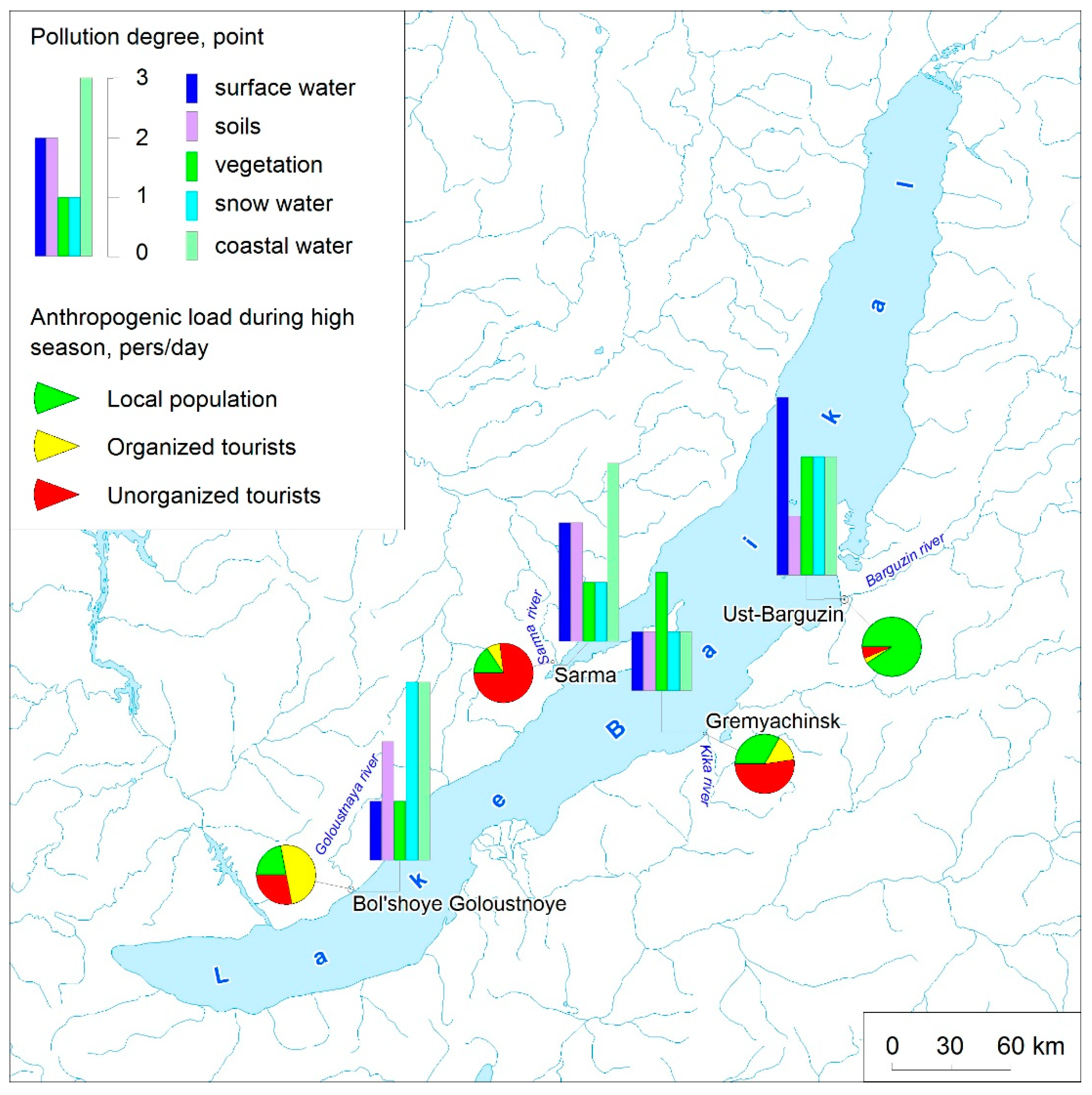
| Mouth Area | River Water | Soils | Vegetation | Snow Water | Lake Water | Mouth Area, Taken as a Whole | ||||||
|---|---|---|---|---|---|---|---|---|---|---|---|---|
| the MPC Exceedance Frequency, Times | Points | the MPC Exceedance Frequency, Times | Points | the MPC Exceedance Frequency, Times | Points | the MPC Exceedance Frequency, Times | Points | the MPC Exceedance Frequency, Times | Points | Contami nation | Points | |
| Goloustanya | <1 | 1 | 1.2–3.8 | 2 | <1 | 1 | >5 | 3 | 1–7 | 3 | High | 10 |
| Sarma | 3–5 | 2 | 1.2–4 | 2 | <1 | 1 | <1 | 1 | <1 | 1 | Medium | 7 |
| Barguzin | 1.6–77 | 3 | <1 | 1 | 1–3.5 | 2 | 3–5 | 2 | 1–10 | 3 | High | 1 |
| Kika | 1–2 | 1 | <1 | 1 | 1–2 | 2 | <1 | 1 | <1 | 1 | Medium | 6 |
| Mouth Area | Surface Water (Self-Purification) | Floodplain–Channel Complex | Soils | Vegetation | Natural Mouth Area, Taken as a Whole |
|---|---|---|---|---|---|
| Goloustanya | Low | Low | Medium | Medium | Medium |
| Sarma | Low | Low | Low | Medium | Low |
| Barguzin | Medium | Medium | Medium | Medium | Medium |
| Kika | Low | Medium | Low | Low | Low |
| Mouth Area | Landscapes | Local Population and Tourists in High Season, Per/Day * | Integral Indicator of Ecological State | |
|---|---|---|---|---|
| Stability | Contamination | |||
| Goloustanya–vil. Bol. Goloustnoe | Medium | High | 2000–3000 | Critical |
| Sarma–vil. Sarma | Low | Medium | 100–1000 | Environmental stress |
| Barguzin–vil. Ust’-Barguzin | Medium | High | 7000–8000 | Critical |
| Kika–vil. Gremyachinsk | Low | Medium | 2000–3000 | Environmental stress |
Publisher’s Note: MDPI stays neutral with regard to jurisdictional claims in published maps and institutional affiliations. |
© 2021 by the authors. Licensee MDPI, Basel, Switzerland. This article is an open access article distributed under the terms and conditions of the Creative Commons Attribution (CC BY) license (https://creativecommons.org/licenses/by/4.0/).
Share and Cite
Gagarinova, O.V.; Belozertseva, I.A.; Vorobyeva, I.B.; Vlasova, N.V.; Emelyanova, N.V.; Sorokovoi, A.A. Anthropogenic Transformations in the Mouth Area of Tributaries as Factors of Negative Impact on Lake Baikal. Water 2021, 13, 1295. https://doi.org/10.3390/w13091295
Gagarinova OV, Belozertseva IA, Vorobyeva IB, Vlasova NV, Emelyanova NV, Sorokovoi AA. Anthropogenic Transformations in the Mouth Area of Tributaries as Factors of Negative Impact on Lake Baikal. Water. 2021; 13(9):1295. https://doi.org/10.3390/w13091295
Chicago/Turabian StyleGagarinova, Olga V., Irina A. Belozertseva, Irina B. Vorobyeva, Natalia V. Vlasova, Natalia V. Emelyanova, and Andrei A. Sorokovoi. 2021. "Anthropogenic Transformations in the Mouth Area of Tributaries as Factors of Negative Impact on Lake Baikal" Water 13, no. 9: 1295. https://doi.org/10.3390/w13091295