
Adaptation Strategies for Flooding Risk from Rainfall Events in Southeast Spain: Case Studies from the Bajo Segura, Alicante


Abstract
:1. Introduction
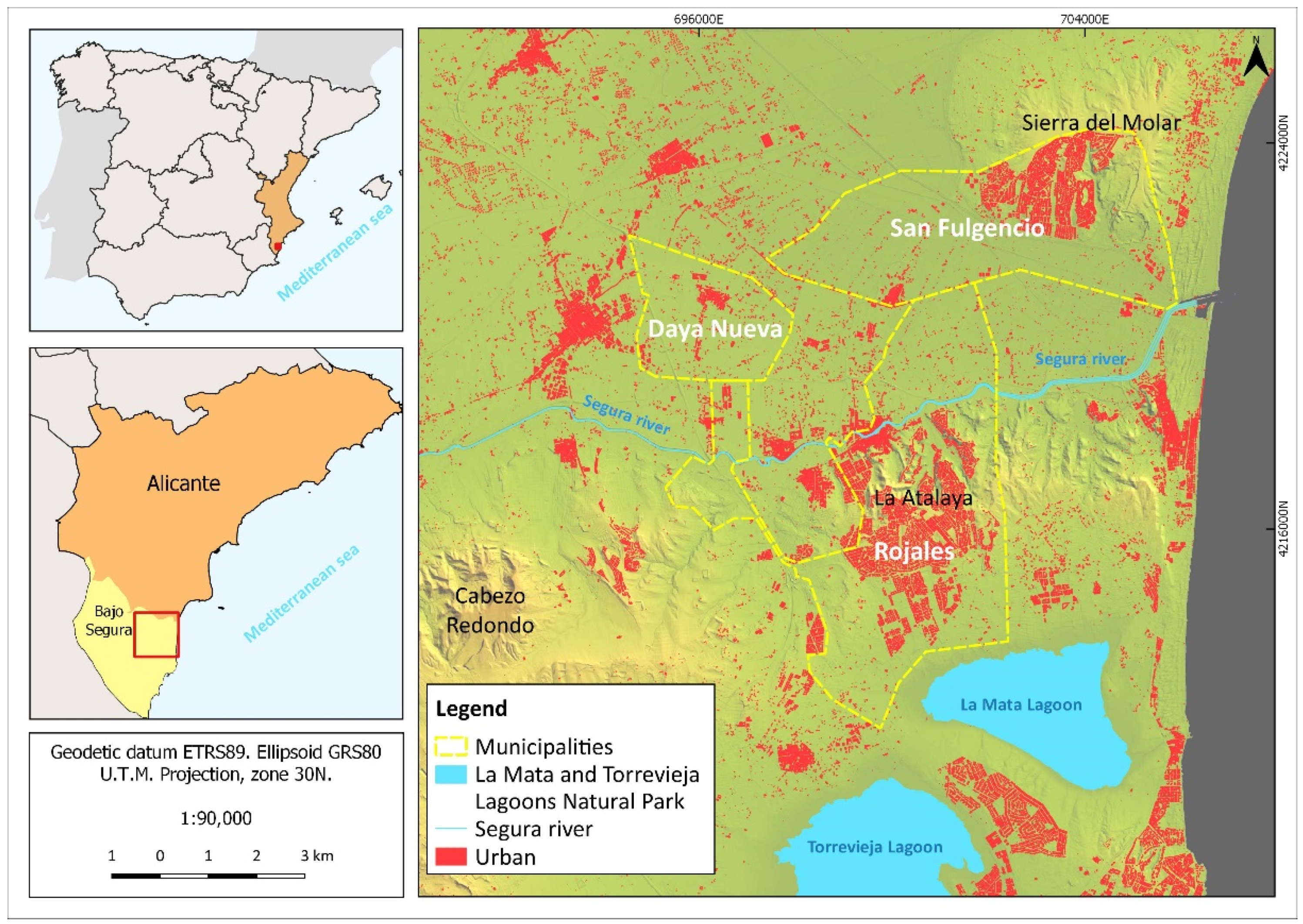
2. Study Area
3. Methodology
4. Results
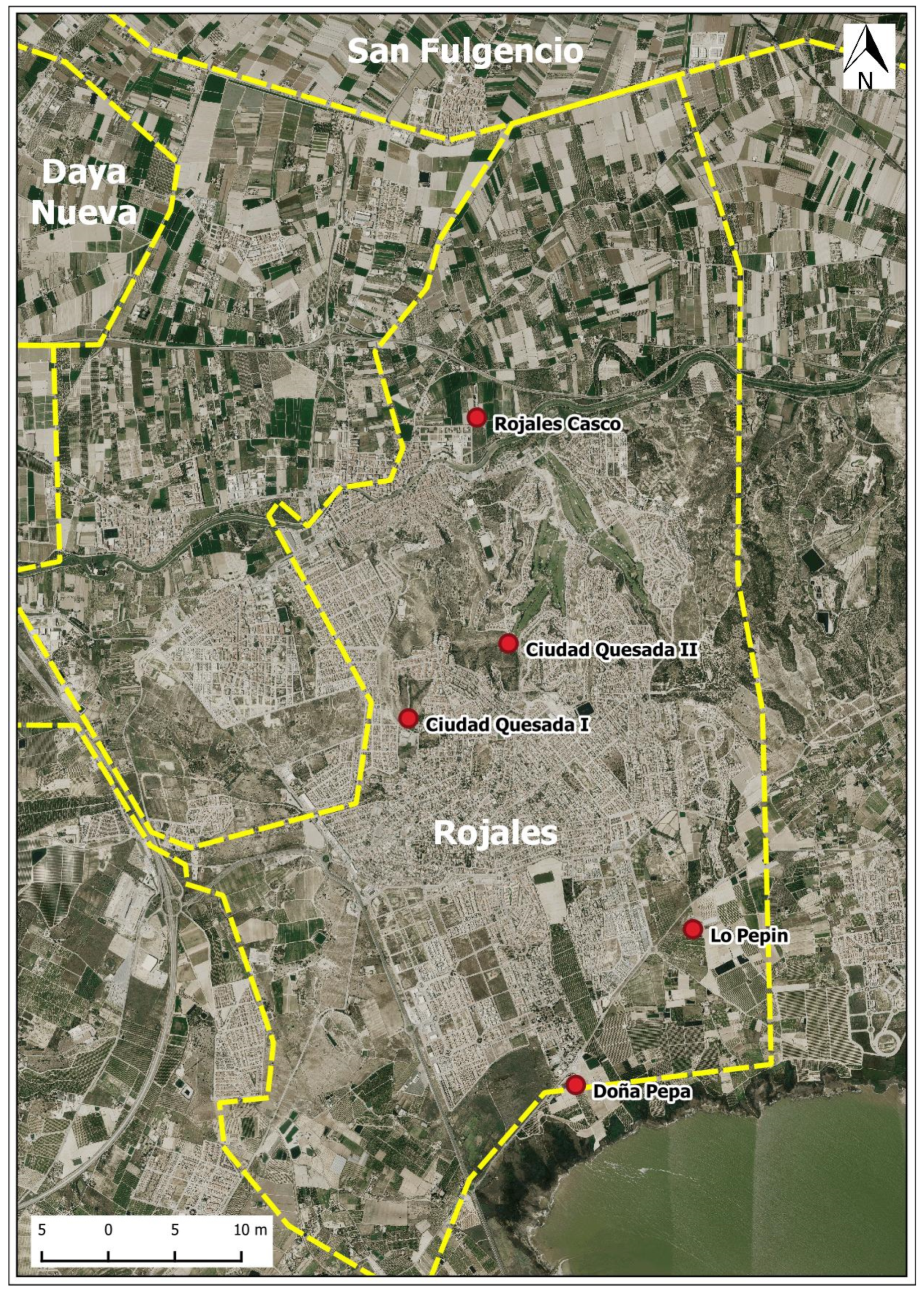
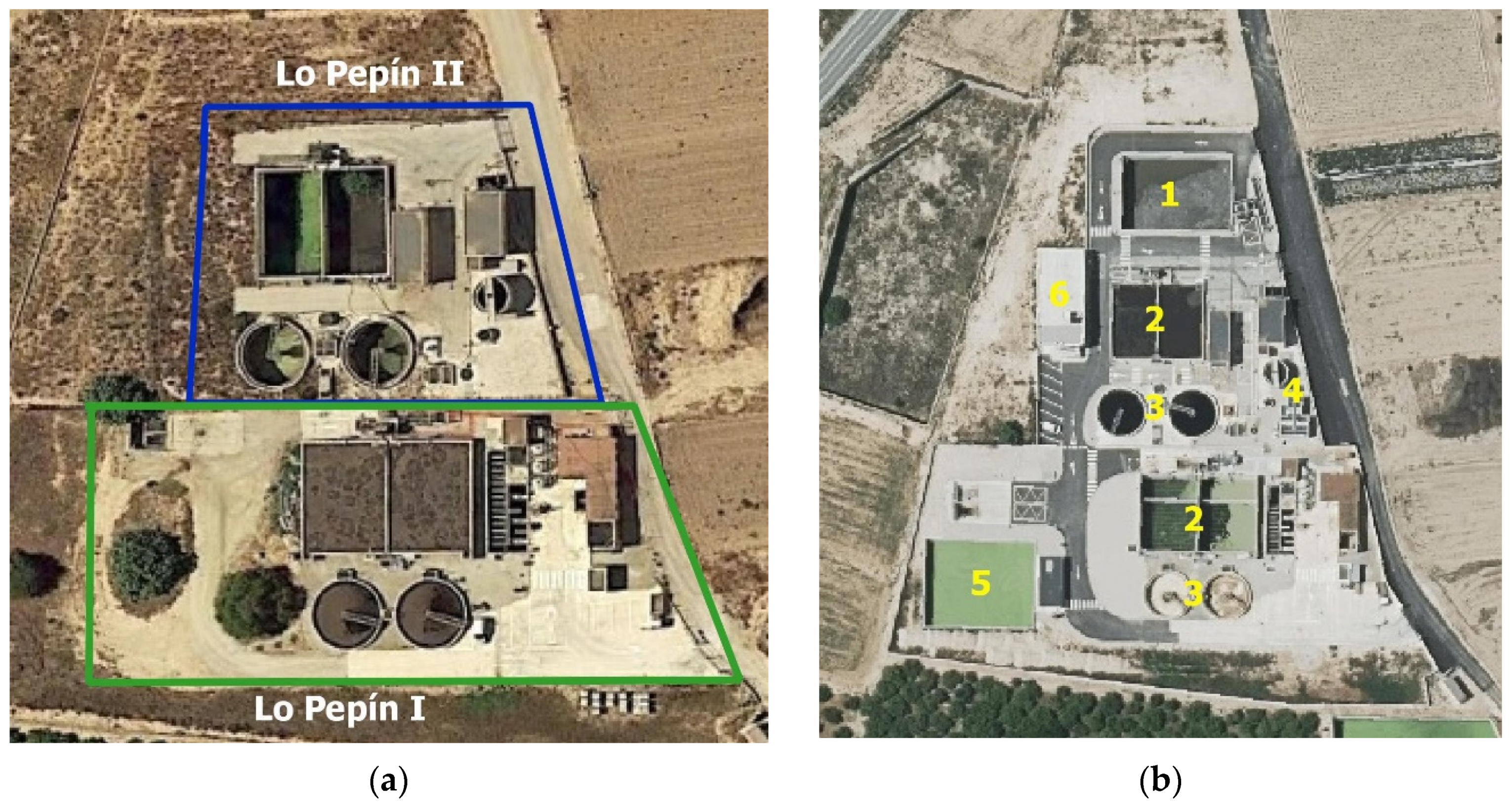
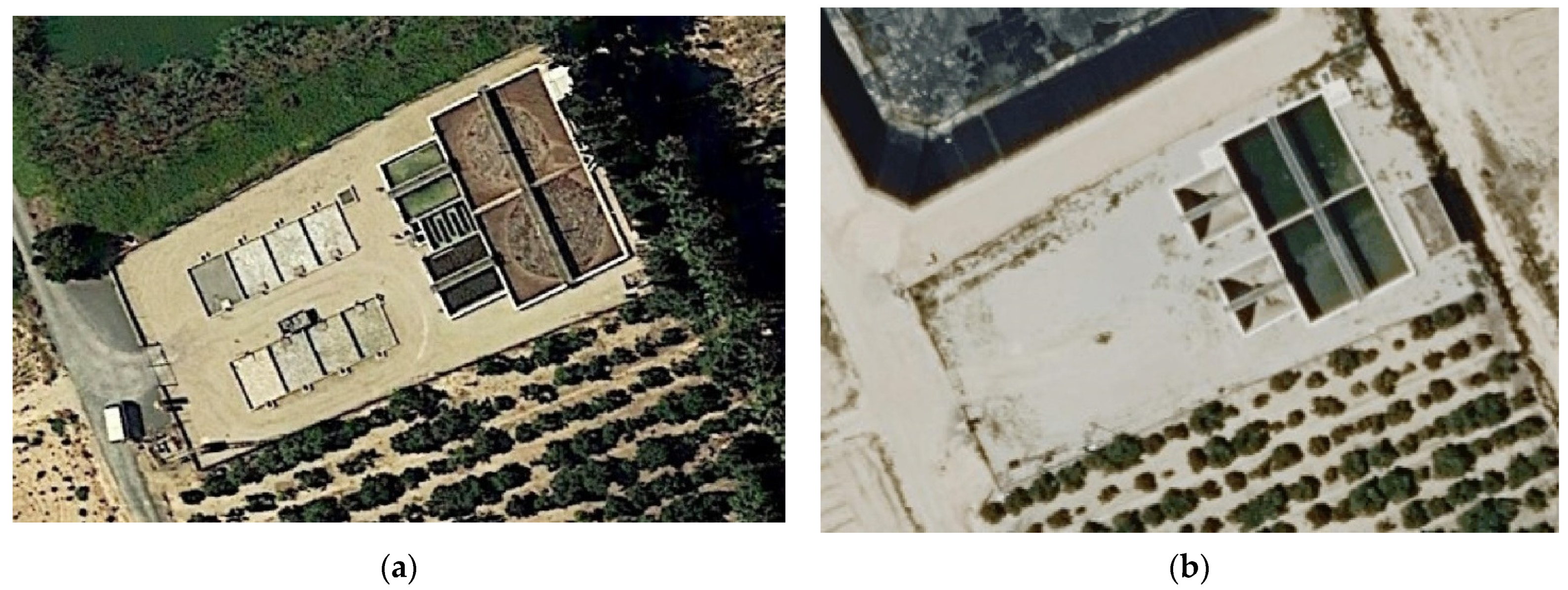
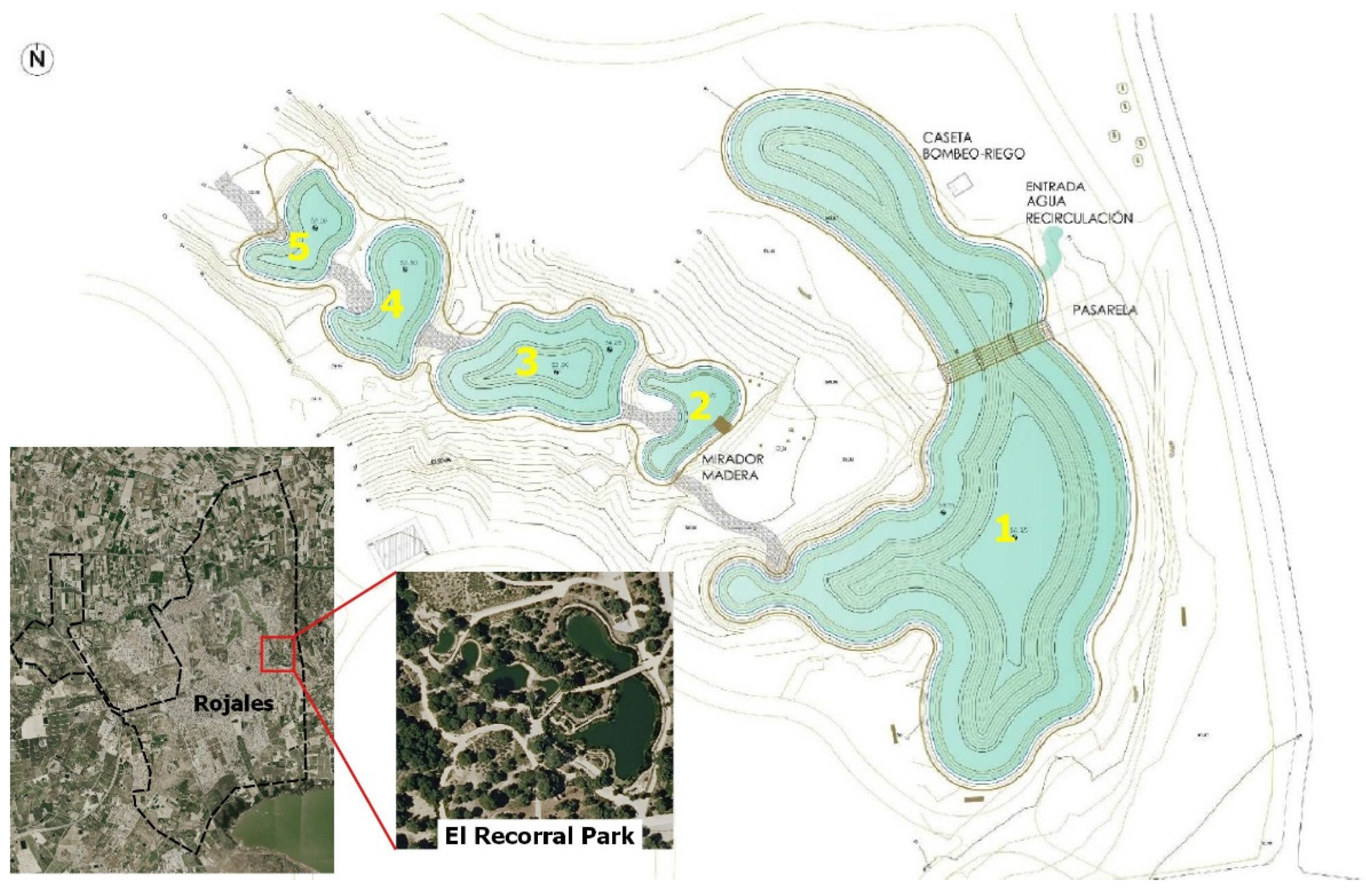
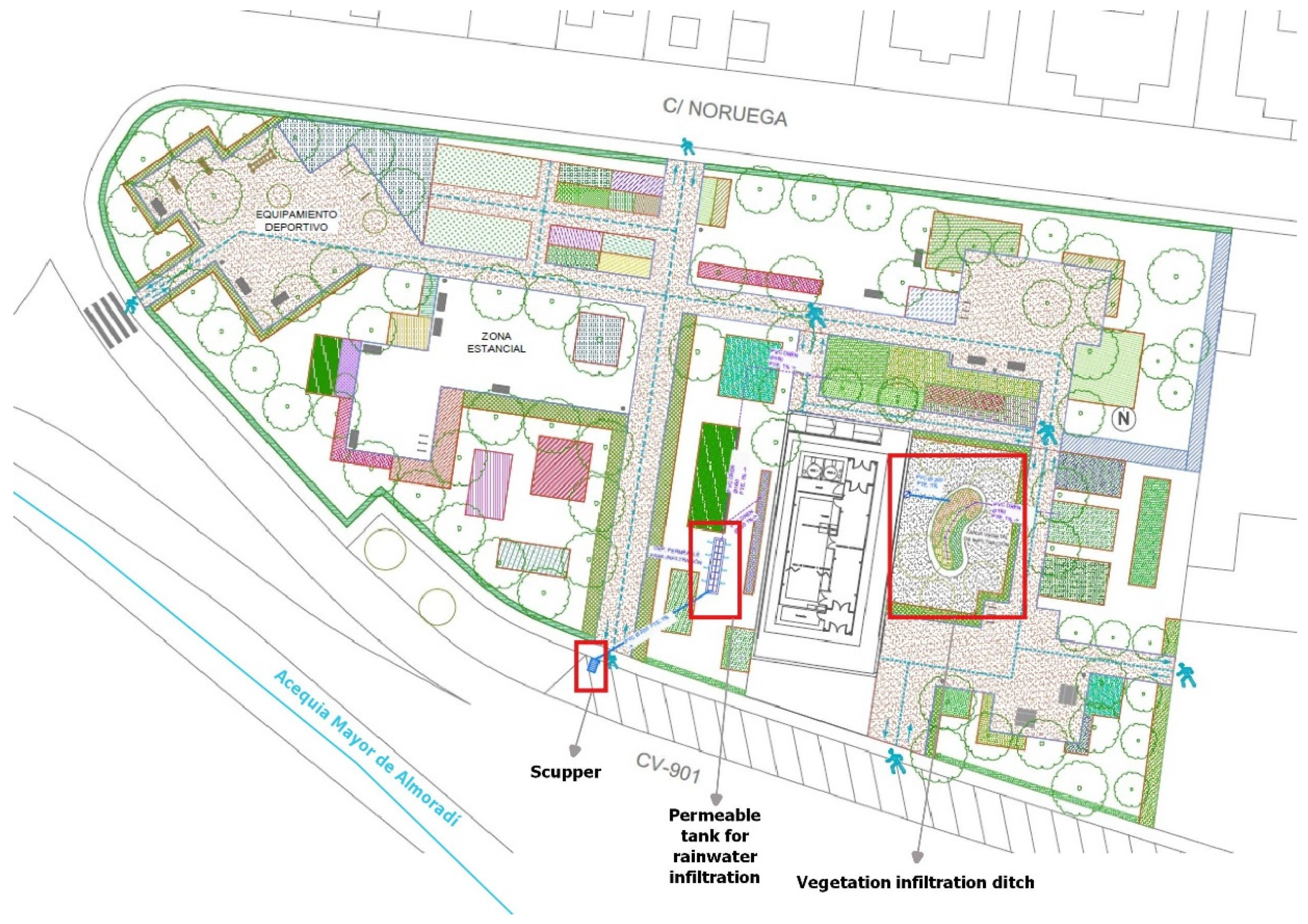
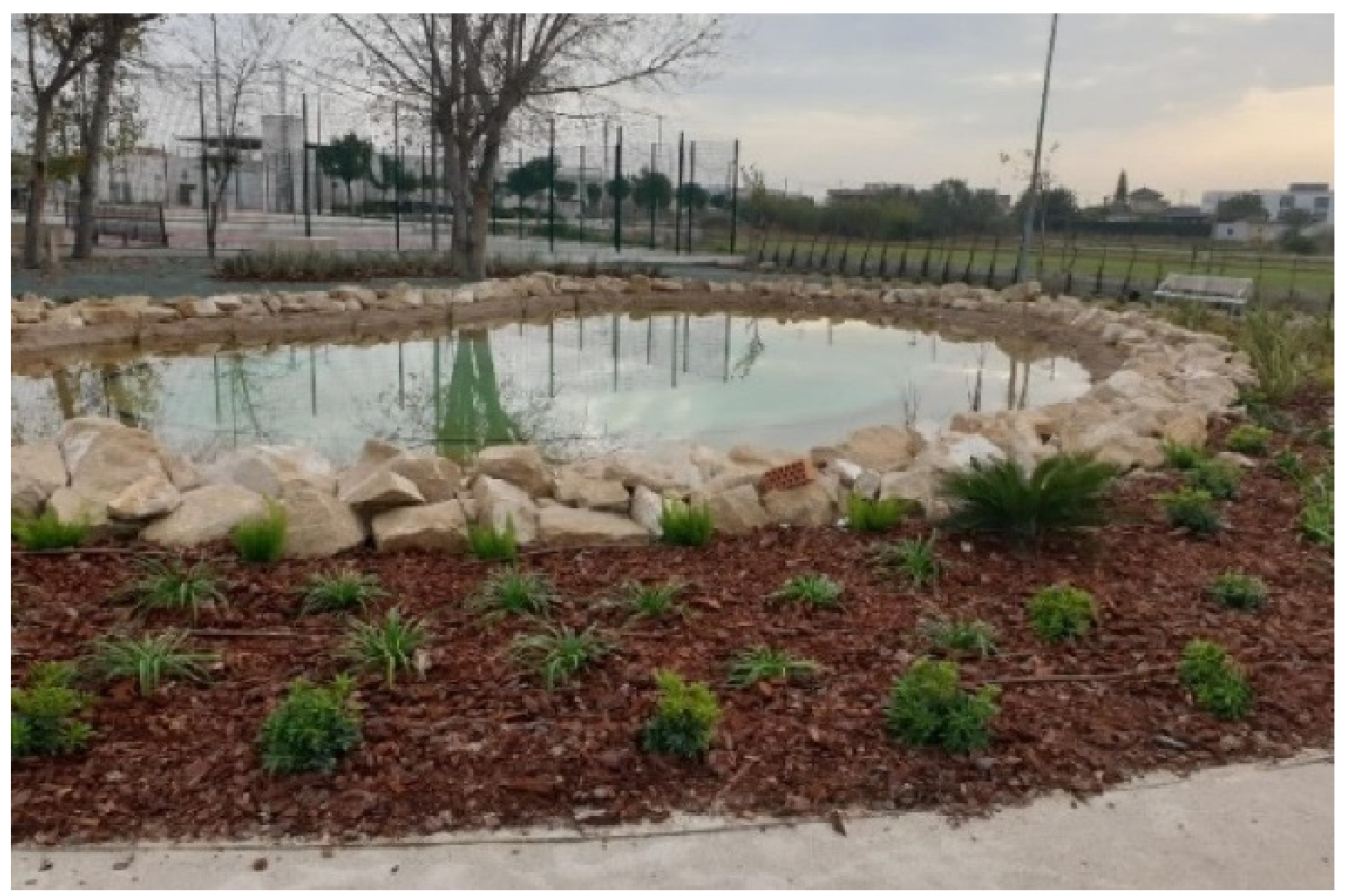
4.1. Rojales
4.2. Daya Nueva
4.3. San Fulgencio
5. Discussion
6. Conclusions
Author Contributions
Funding
Institutional Review Board Statement
Informed Consent Statement
Data Availability Statement
Acknowledgments
Conflicts of Interest
References
- Intergovernmental Panel on Climate Change (IPCC). Cambio Climático 2014: Informe de Síntesis. Contribución de los Grupos de Trabajo I, II y III al Quinto Informe de Evaluación del Grupo Intergubernamental de Expertos Sobre el Cambio; IPCC: Ginebra, Switzerland, 2014. [Google Scholar]
- Intergovernmental Panel on Climate Change (IPCC). Global Warming of 1.5 °C—An IPCC Special Report on the Impacts of Global Warming of 1.5 °C Above Pre-Industrial Levels and Related Global Greenhouse Gas Emission Pathways, in the Context of Strengthening the Global Response to the Threat of Climate Change; IPCC: París, France, 2018. [Google Scholar]
- Intergovernmental Panel on Climate Change (IPCC). Climate Change and Land: An IPCC Special Report on Climate Change, Desertification, Land Degradation, Sustainable Land Management, Food Security, and Greenhouse Gas Fluxes in Terrestrial Ecosystems; IPCC: Geneva, Switzerland, 2019. [Google Scholar]
- Olcina Cantos, J. Incremento de episodios de inundación por lluvias de intensidad horaria en el sector central del litoral Mediterráneo Español: Análisis de tendencias en Alicante. Sémata: Cienc. Sociais Humanid. 2017, 29, 143–163. [Google Scholar] [CrossRef] [Green Version]
- Olcina Cantos, J.; Biener Camacho, S. Evidencias del proceso de calentamiento térmico planetario en el litoral mediterráneo español. In Spanish Contribution to 34th IGC. Istanbul 2020 Spanish Committee of the International Geographical Union. Spain, Bridge between Continents, 1st ed.; Comité Español de la Unión Geográfica Internacional (UGI); Centro Nacional de Información Geográfica: Madrid, Spain, 2020; pp. 155–166. [Google Scholar] [CrossRef]
- Olcina Cantos, J.; Vera-Rebollo, J.F. Adaptación del sector turístico al cambio climático en España. La importancia de las acciones a escala local y en empresas turísticas. An. Geogr. Univ. Complut. 2016, 36, 321–352. [Google Scholar] [CrossRef] [Green Version]
- Olcina Cantos, J.; Campos Rosique, A.; Casals del Busto, I.; Ayanz López-Cuervo, J.; Rodríguez Mateos, M.; Martínez Puentes, M. Resiliencia en el ciclo urbano del agua. Extremos pluviométricos y adaptación al cambio climático en el ámbito Mediterráneo. Aquae Pap. 2018, 8, 1–193. Available online: http://rua.ua.es/dspace/handle/10045/76370 (accessed on 30 November 2021).
- Eckstein, D.; Künzel, V.; Schäfer, L. Global Climate Risk Index 2021. Who Suffers Most from Extreme Weather Events? Weather-Related Loss Events in 2019 and 2000 to 2019; Germanwatch: Berlin, Germany, 2021; p. 49. Available online: https://germanwatch.org/es/19777 (accessed on 14 October 2021).
- Shen, G.; Hwang, S.N. Spatial–Temporal snapshots of global natural disaster impacts Revealed from EM-DAT for 1900–2015. Geomat. Nat. Hazards Risk 2019, 10, 912–934. [Google Scholar] [CrossRef] [Green Version]
- Pérez Morales, A.; Gil Guirado, S.; Olcina Cantos, J. Housing bubbles and the increase of flood exposure. Failures in flood risk management on the Spanish south-eastern coast (1975–2013). Flood Risk Manag. 2015, 11, 1–12. [Google Scholar] [CrossRef]
- Olcina Cantos, J.; Hernández Hernández, M.; Rico Amorós, A.M.; Martínez Ibarra, E. Increased risk of flooding on the coast of Alicante (Region of Valencia, Spain). Nat. Hazards Earth Syst. Sci. 2010, 10, 2229–2234. [Google Scholar] [CrossRef] [Green Version]
- Gil-Guirado, S.; Pérez-Morales, A.; López-Martínez, F. SMC-Flood database: A high-resolution press database on flood cases for the Spanish Mediterranean coast (1960–2015). Nat. Hazards Earth Syst. Sci. 2019, 19, 1955–1971. [Google Scholar] [CrossRef] [Green Version]
- European Spatial Planning Observation Network (ESPON). The Spatial Effects and Management of Natural and Technological Hazards in Europe. 2006. Available online: https://www.espon.eu/sites/default/files/attachments/Final%20Report%20Main%20Report.pdf (accessed on 17 November 2021).
- Jato-Espino, D.; Sillanpää, N.; Andrés-Doménech, I.; Rodriguez-Hernandez, J. Flood risk assessment in urban catchments using multiple regression analysis. J. Water Resour. Plan. Manag. 2018, 144, 04017085. [Google Scholar] [CrossRef] [Green Version]
- Woods-Ballard, B.; Wilson, S.; Udale-Clarke, H.; Illman, S.; Scott, T.; Ashley, R.; Kellagher, R. The SuDS Manual, 5th ed.; CIRIA: London, UK, 2015. [Google Scholar]
- Perales-Momparler, S.; Andrés-Doménech, I.; Hernández-Crespo, C.; Vallés-Morán, F.; Martín, M.; Escuder-Bueno, I.; Andreu, J. The role of monitoring sustainable drainage systems for promoting transition towards regenerative urban built environments: A case study in the Valencian region, Spain. J. Clean. Prod. 2017, 163, S113–S124. [Google Scholar] [CrossRef]
- Eguibar, M.Á.; Porta-García, R.; Torrijo, F.J.; Garzón-Roca, J. Flood Hazards in Flat Coastal Areas of the Eastern Iberian Peninsula: A Case Study in Oliva (Valencia, Spain). Water 2021, 13, 2975. [Google Scholar] [CrossRef]
- Fundación Nueva Cultura del Agua (FNCA). Fundación Nueva Cultura del Agua. Available online: https://fnca.eu/en/ (accessed on 2 July 2021).
- European Communities. Directive 2000/60/EC of the European Parliament and of the Council of 23 October 2000 establishing a framework for Community action in the field of water policy. Off. J. Eur. Communities 2000, 43, 1–75. Available online: http://data.europa.eu/eli/dir/2000/60/oj (accessed on 1 April 2021).
- Castro-Fresno, D.; Andrés-Valeri, V.C.; Sañudo-Fontaneda, L.A.; Rodriguez-Hernandez, J. Sustainable drainage practices in Spain, specially focused on pervious pavements. Water 2013, 5, 67–93. [Google Scholar] [CrossRef]
- España. Ministerio de la Presidencia. Real Decreto 903/2010, de 9 de Julio, de Evaluación y Gestión de Riesgos de Inundación. Boletín Estado 2010, 171, 61954–61967. Available online: https://www.boe.es/eli/es/rd/2010/07/09/903 (accessed on 1 April 2021).
- España. Ministerio de Agricultura y Pesca, A. y M. A. Real Decreto 638/2016, de 9 de diciembre, por el que se modifica el Reglamento del Dominio Público Hidráulico aprobado por el Real Decreto 849/1986, de 11 de abril, el Reglamento de Planificación Hidrológica, aprobado por el Real Decreto 907/2007, de 6 de. Boletín Estado 2016, 314, 91133–91175. [Google Scholar]
- de Agricultura, M.; Ambiente, A.Y.M. Manual Nacional de Recomendaciones para el Diseño de Tanques de Tormenta; MAGRAMA: Madrid, Spain, 2014; Available online: https://www.aeas.es/images/publicaciones/manuales/Manual_Tanques_Tormenta_MAGRAMA.pdf (accessed on 27 March 2021).
- Pérez Zabaleta, A.; Gracia de Rentería, P.; Ballestero Olza, M.; Pérez Foguet, A.; Ezbakhe, F.; Guerra-Librero Castilla, A. Análisis de las Necesidades de Inversión en Renovación de las Infraestructuras del Ciclo Urbano del Agua, 1st ed.; Universidad Nacional de Educación a Distancia (UNED) y Fundación Aguae: Madrid, Spain, 2019. [Google Scholar] [CrossRef]
- Arahuetes, A.; Olcina Cantos, J. The potential of sustainable urban drainage systems (SuDS) as an adaptive strategy to climate change in the Spanish Mediterranean. Int. J. Environ. Stud. 2019, 76, 764–779. [Google Scholar] [CrossRef]
- Fernández Rodríguez, H.; Trapote Jaume, A.; Fernández Mejuto, M. Sistemas Urbanos de Drenaje Sostenible. Tipos y objetivos. In Riesgo de inundación en España: Análisis y Soluciones para la Generación de Territorios Resilientes, 1st ed.; López Ortiz, M.I., Melgarejo Moreno, J., Eds.; Alicante, Universidad de Alicante: Orihuela, Spain, 2020; pp. 773–786. [Google Scholar]
- Fresno, D.C.; Bayón, J.R.; Hernández, J.R.; Muñoz, F.B. Sistemas Urbanos de Drenaje Sostenible (SUDS). Interciencia 2005, 30, 1–25. Available online: http://www.redalyc.org/articulo.oa?id=33910403 (accessed on 30 November 2021).
- Morote Seguido, Á.F.; Hernández Hernández, M. El uso de aguas pluviales y de tormenta en la ciudad de Alicante. De riesgo a recurso hídrico alternativo. In XV Coloquio Ibérico de Geografía. Retos y tendencias de la Geografía Ibérica. Murcia, España, 7–9 Novimebre 2016; García Marín, R., Alonso Sarría, F., Belmonte Serrato, F., Moreno Muñoz, D., Eds.; Universidad de Murcia y Asociación de Geógrafos Españoles: Murcia, Spain, 2016; pp. 1008–1015. [Google Scholar]
- Morote Seguido, Á.F.; Hernández Hernández, M. El uso de aguas pluviales en la ciudad de Alicante. De viejas ideas a nuevos enfoques. Pap. Geogr. 2017, 1, 7–25. [Google Scholar] [CrossRef]
- Perales Momparler, S. Sistemas Urbanos de Drenaje Sostenible (SUDS)—Expo Zaragoza 2008—Agua Y Serv—De Abastecimiento Y Saneam. 2008. Available online: http://www.zaragoza.mobi/contenidos/medioambiente/cajaAzul/33S8-P3-SaraPeralesACC.pdf (accessed on 28 March 2021).
- Andrés-Doménech, I.; Hernández-Crespo, C.; Martín, M.; Andrés-Valeri, V.C. Characterization of wash-off from urban impervious surfaces and SuDS design criteria for source control under semi-arid conditions. Sci. Total Environ. 2018, 612, 1320–1328. [Google Scholar] [CrossRef] [PubMed]
- Perales-Momparler, S.; Hernández-Crespo, C.; Vallés-Morán, F.; Martín, M.; Andrés-Doménech, I.; Andreu Álvarez, J.; Jefferies, C. SuDS efficiency during the start-up period under Mediterranean climatic conditions. Clean Soil Air Water 2014, 42, 178–186. [Google Scholar] [CrossRef] [Green Version]
- Perales Momparler, S.; Andrés-Doménech, I. Los sistemas urbanos de drenaje sostenible: Una alternativa a la gestión del agua de lluvia. Retema Rev. Técnica Medio Ambiente 2008, 21, 92–104. [Google Scholar]
- Trapote Jaume, A. Influencia de los Sistemas Urbanos de Drenaje Sostenible (SUDS) en el diseño de colectores y en el riesgo de inundación. In Riesgo de Inundación en España: Análisis y Soluciones para la Generación de Territorios Resilientes, 1st ed.; López Ortiz, M.I., Melgarejo Moreno, J., Eds.; Universidad de Alicante: Orihuela, Spain, 2020; pp. 787–797. [Google Scholar]
- Perales, S.; Andrés, I.; Escalante, E.; Los Sistemas Urbanos de Drenaje Sostenible (SUDS) en la Hidrogeología Urbana. IX Simposio de Hidrogeología; AEH-IGME: Elche, Spain, 2008; pp. 1–12. Available online: https://www.researchgate.net/publication/265057760_Los_sistemas_urbanos_de_drenaje_sostenible_SUDS_en_la_hidrogeologia_urbana (accessed on 27 March 2021).
- Soto-Fernández, R.; Perales-Momparler, S. El camino del agua en el paisaje urbano, barrio de Bon Pastor, Barcelona. In Proceedings of the V Water Engineering Conference, A Coruña, Spain, 24–26 October 2017; pp. 1–9. [Google Scholar]
- Andrés-Doménech, I. Una apuesta decidida por el drenaje urbano sostenible. El Econ. 2017, 46, 20–21. [Google Scholar]
- Generalitat Valenciana. Plan Vega Renhace. Una Estrategia Integral para la Resiliencia de la Comarca de la Vega Baja del Segura; Generalitat Valenciana: Valencia, Spain, 2020; Available online: http://www.presidencia.gva.es/es/web/vega-renhace (accessed on 1 April 2021).
- García de Consuegra Priego, M.E. Experiencias y propuestas para aumentar la resiliencia urbana frente a inundaciones. In Riesgo de Inundación en España: Análisis y Soluciones para la Generación de Territorios Resilientes; López Ortiz, M.I., Melgarejo Moreno, J., Eds.; Universidad de Alicante: Orihuela, Spain, 2020; pp. 569–589. Available online: http://hdl.handle.net/10045/109017 (accessed on 30 November 2021).
- KWR. B-WaterSmart European Project. European Commision, Horizon 2020. 2021. Available online: https://www.kwrwater.nl/en/projecten/b-watersmart/ (accessed on 14 November 2021).
- Instituto Geográfico Nacional (IGN). Nomenclátor Geográfico de Municipios y Entidades de Población. Available online: http://centrodedescargas.cnig.es/CentroDescargas/catalogo.do?Serie=NGMEN (accessed on 20 December 2021).
- Morote, Á.F.; Hernández, M. Población extranjera y turismo residencial en el litoral de Alicante (1960–2011): Repercusiones territoriales. Eure 2016, 42, 55–76. [Google Scholar] [CrossRef] [Green Version]
- Ministerio de Hacienda y Función Pública. Portal de la Dirección General de Catastro: Estadísticas Catastrales. Catastro Inmobiliario Urbano. Available online: http://www.catastro.minhap.gob.es/esp/estadistica_2.asp (accessed on 20 December 2021).
- Hidraqua Gestión Integral de Aguas de Levante, S.A. Proyecto Básico para la Reutilización y Autorización de Vertido del Agua Depurada en la Cuenca sur del T.M. de Rojales; Hidraqua y Ayuntamiento de Rojales: Rojales, Spain, 2016; p. 111. [Google Scholar]
- Ministerio de Medio Ambiente. RESOLUCIÓN de 25 de mayo de 1998, de la Secretaría de Estado de Aguas y Costas, por la que se declaran las «zona sensible» en las cuencas hidrográficas intercomunitarias. Boletín Estado 1998, 155, 34635–34636. [Google Scholar]
- Gobierno de España. Ministerio de la Presidencia. Real Decreto 1620/2007, de 7 de diciembre, por el que se establece el régimen jurídico de la reutilización de las aguas depuradas. Boletín Estado 2007, 294, 50639–50661. [Google Scholar]
- Diario Información. San Fulgencio Regará con Agua Regenerada. 2017. Available online: https://www.informacion.es/vega-baja/2017/09/26/san-fulgencio-regara-agua-regenerada-5879270.html (accessed on 13 January 2021).
- De Graaf, R.; Van der Brugge, F. Transforming water infrastructure by linking water management and urban renewal in Rotterdam. Technol. Forecast. Soc. Change 2010, 77, 1282–1291. [Google Scholar] [CrossRef]
- Olcina, J.; Vera, J.F. Climate change and tourism policy in Spain: Giagnosis in the Spanish Mediterranean. Cuad. Tur. 2016, 38, 565–571. [Google Scholar] [CrossRef]
- Olcina, J.; Miró Pérez, J.J. Actividad Turística y Cambio Climático en la Comunidad Valenciana; Universidad de Alicante: Alicante, Spain; Instituto Universitario de Investigaciones Turísticas: Alicante, Spain; Agència Valenciana del Turisme: Valencia, Spain, 2017; p. 130. [Google Scholar]
- Amelung, B. The Rotterdam Climate Change Adaptarion Strategy. In Cambio Climático en el Mediterráneo. Procesos, Riesgos y Políticas, 1st ed.; Romero, J., Olcina, J., Eds.; Tirant Humanidades: Valencia, Spain, 2021; pp. 303–309. [Google Scholar]
- Hernández Hernández, M.; Saurí Pujol, D.; Moltó Mantero, E. Las aguas pluviales y de tormenta: Del abandono de un recurso hídrico con finalidad agrícola a su implantación como recurso no convencional en ámbitos urbanos. In Paisaje, Cultura Territorial y Vivencia de la Geografía. Libro Homenaje al Profesor Alfredo Morales Gil, 1st ed.; Vera, J.F., Olcina Cantos, J., Hernández, M., Eds.; Alicante, Servicio de Publicaciones de la Universidad de Alicante: Alicante, Spain, 2016; pp. 1099–1120. [Google Scholar] [CrossRef] [Green Version]
- Casal-Campos, A.; Jefferies, C.; Perales Momparler, S. Selecting SUDS in the Valencia Region of Spain. Water Pract. Technol. 2012, 7, 1. [Google Scholar] [CrossRef]
- Perales Momparler, C.S. A Regenerative Urban Stormwater Management Methodology. The Role of SUDS Construction and Monitoring. In the Transition of a Mediterranean City. Ph.D. Thesis, Universitat Politècnica de València, Valencia, Spain, 2015. [Google Scholar]
- Rosselló-Geli, J.; Grimalt-Gelabert, M. Mapping of the Flood Distribution in an Urban Environment: The Case of Palma (Mallorca, Spain) in the First Two Decades of the 21st Century. Earth 2021, 2, 960–971. [Google Scholar] [CrossRef]
- Domènech, L.; Vallès, M. Local regulations on alternative water sources: Greywater and rainwater use in the Metropolitan Region of Barcelona. Investig. Geográficas 2014, 61, 87–96. [Google Scholar] [CrossRef] [Green Version]
- Domènech, L.; Saurí, D. A comparative appraisal of the use of rainwater harvesting in single and multi-family buildings of the Metropolitan Area of Barcelona (Spain): Social experience, drinking water savings and economic costs. J. Clean. Prod. 2011, 19, 598–608. [Google Scholar] [CrossRef]
- Villar-Navascués, R.; Pérez-Morales, A.; Gil-Guirado, S. Evaluación del potencial de captación de aguas pluviales en tejados en Alicante. In Tecnologías de la Información Geográfica: Perspectivas Multidisciplinares en la Sociedad del Conocimiento, 1st ed.; López García, M.J., Carmona, P., Saom, J., Albertos, J.M., Eds.; Valencia, Universidad de València: Valencia, Spain, 2018; pp. 433–443. [Google Scholar]
- Villar Navascués, R.; Pérez Morales, A.; Gil Guirado, S. Assessment of rainwater harvesting potential from roof catchments through clustering analysis. Water 2020, 12, 2623. [Google Scholar] [CrossRef]
- European Commission. Towards an EU Research and Innovation Policy Agenda for Nature-Based Solutions and Re-Naturing Cities. Final Report of the Horizon 2020 Expert Group on Nature-Based Solutions and Re-Naturing Cities (Fill Version); European Commission: Brussels, Belgium, 2015. [Google Scholar] [CrossRef]
- Yin, J.; Gou, S.; Gu, L.; Zeng, Z.; Liu, D.; Chen, J.; Shen, Y.; Xu, C. Does the Hook Structure Constrain Future Flood Intensification Under Anthropogenic Climate Warming? Water Resour. Res. 2021, 57, 125878. [Google Scholar] [CrossRef]
- Yin, J.; Guo, S.; Gentine, P.; Sullivan, S.C.; Gu, L.; He, S.; Chen, J.; Liu, P. Blending multi-satellite, atmospheric reanalysis and gauge precipitation products to facilitate hydrological modelling. J. Hydrol. 2021, 593, 125878. [Google Scholar] [CrossRef]


| Measure | Location | Construction Date | Management |
|---|---|---|---|
| El Recorral Park | Rojales | May 2019 | Hidraqua Gestión Integral de Aguas de Levante SA |
| Remodelling of Lo Pepín WWTP | Rojales | November 2019 | |
| Combined sewer system storm overflow tank Doña Pepa | Rojales | January 2021 | |
| Europa Park | Daya Nueva | November 2020 | |
| Floodable Pond | San Fulgencio | December 2019 |
| Treated Water in the Southern Basin of the Municipality of Rojales WWTP | |
|---|---|
| Treated Water (m3/day) | |
| Lo Pepín | 921 |
| Doña Pepa | 223 |
| Ciudad Quesada II | 85 |
| Total (m3/day) | 1229 |
| Total (m3/year) | 448,585 |
| USES (m3/year) | |
| La Marquesa Golf Course | 275,000 |
| Irrigation | 17,710 |
| Irrigation Association | 23,395 |
| Total | 320,395 |
| Surplus treated water without reuse | 128,480 |
Publisher’s Note: MDPI stays neutral with regard to jurisdictional claims in published maps and institutional affiliations. |
© 2022 by the authors. Licensee MDPI, Basel, Switzerland. This article is an open access article distributed under the terms and conditions of the Creative Commons Attribution (CC BY) license (https://creativecommons.org/licenses/by/4.0/).
Share and Cite
Sánchez-Almodóvar, E.; Olcina-Cantos, J.; Martí-Talavera, J. Adaptation Strategies for Flooding Risk from Rainfall Events in Southeast Spain: Case Studies from the Bajo Segura, Alicante. Water 2022, 14, 146. https://doi.org/10.3390/w14020146
Sánchez-Almodóvar E, Olcina-Cantos J, Martí-Talavera J. Adaptation Strategies for Flooding Risk from Rainfall Events in Southeast Spain: Case Studies from the Bajo Segura, Alicante. Water. 2022; 14(2):146. https://doi.org/10.3390/w14020146
Chicago/Turabian StyleSánchez-Almodóvar, Esther, Jorge Olcina-Cantos, and Javier Martí-Talavera. 2022. "Adaptation Strategies for Flooding Risk from Rainfall Events in Southeast Spain: Case Studies from the Bajo Segura, Alicante" Water 14, no. 2: 146. https://doi.org/10.3390/w14020146