
Peat Thickness Changes at the “Wołosate” Raised Bog in the Western Bieszczady Mountains

1
Department of Land Reclamation and Environmental Development, University of Agriculture in Krakow, 31-120 Krakow, Poland
2
Department of Land Surveying, University of Agriculture in Krakow, 31-120 Krakow, Poland
*
Author to whom correspondence should be addressed.
Water 2022, 14(22), 3659; https://doi.org/10.3390/w14223659
Submission received: 11 September 2022
/
Revised: 4 November 2022
/
Accepted: 11 November 2022
/
Published: 13 November 2022
(This article belongs to the Special Issue Peatlands under Changing Environment)
Abstract
:The study aims to present and analyze the rate of changes that occur in the area of Wołosate bog dome as a result of human pressure, which has been especially intense the period between 1967–2016. Additionally, the work presents current stratigraphic cross-section of the peat deposit, and illustrates and interprets the course of the peat accumulation process, that depends on hydrological conditions. The described study had been conducted on the area of “Wołosate” raised bog (nature reserve) in Western Bieszczady Mountains. From the analysis of data obtained from precise satellite surveys, it can be concluded that over 49 years, the average thickness of peat in the characteristic levelling-stratigraphic cross-section decreased by 27.2%. The most significant changes (34.3%) took place up until 1988, as during that period, the stream valley of Wołosatka river had been drained. The results of the discussed study indicate one more circumstance. In later period (1988–2016), following the restoration measures, a 35 cm acrotelm layer of Sphagnum peat (Eusphagneti) with a living layer of peat moss which happened to form itself on the western side of the peatland (along a section of approx. 50 m).
1. Introduction
Despite significant efforts that have been taken by numerous scientists around the world, during the previous century, plans to prevent the degradation of peatlands did not succeed. The main cause of degradation was draining peatlands in order to introduce land use changes. However, as in time it turned out that degradation of these ecosystems is a cause of about 5–10% of whole annual carbon dioxide emissions, the restoration of disturbed and degraded peatlands became one of the priorities worldwide [1,2,3]. As reported by Loisel and Galleo-Sala [2], both duration as well as intensity of drainage impact the characteristics that may in the end be decisive with regards to whether the renovation would turn out a success or not. Although restoration may not always make it possible for the degraded land to return to a state in which all ecosystem services are retrieved, we need to take steps to support peatland restoration. One of several ways to restore peatlands is to re-irrigate them quickly [4,5].
As all services and functions of peatland ecosystems cannot be easily restored, it should also be remembered to protect intact peatlands. This is particularly important due to crucial role of peat bogs in mitigating climate change and extreme weather phenomena [6,7,8].
In Poland, despite the significant impact of human pressure on the natural environment, some peatlands of a high valorization degree have been still preserved in their natural or near-natural state. According to Tobolski [9], “they can be referred to as a multi-thematic phenomenon distinguished by its outstanding cognitive value, which serves a major environmental and creative role”. This group includes, for example, a raised bog complex in the Orawa and Nowy Targ Valley [10,11], and some raised bogs in the Western Bieszczady Mountains [12,13,14].
Due to the impact of human pressure, peatlands’ area and thickness decrease over the years and, therefore, they are being a subject to the process of decline. With a view to this, research into magnitude and rate of peatland decline is highly purposeful and advisable, as its results motivate to restore and protect these wetlands of significant natural value. The disappearance of peatlands due to drainage (decession) is mainly caused by three factors: settlement (the so-called compression), peat shrinkage, and the organic matter oxidation [15,16,17]. Findings and the literature on the subject matter have been extensively presented in numerous publications by e.g., Ilnicki [18,19]; Ilnicki and Szajdak [20]; Lipka [21,22]; Lipka et al. [23,24,25]; Egglesman [26]; Okruszko [27]; Kasimir-Klemedtsson [28]; Deverel et al. [29], Waddington [30], Hutchinson [31] and Glina at al. [32]. All of these publications unanimously indicated that the peatland disappearance was mainly due to their drainage.
The main aim of the study was to analyze the changes caused by human pressure during the period 1967–2016 in the dome cross-section of the “Wołosate” raised bog located in Western Bieszczady Mountains. Moreover, it was to present the peat deposit stratigraphy on the background of the hydrological conditions at the time when individual peat species were being formed.
2. Materials and Methods
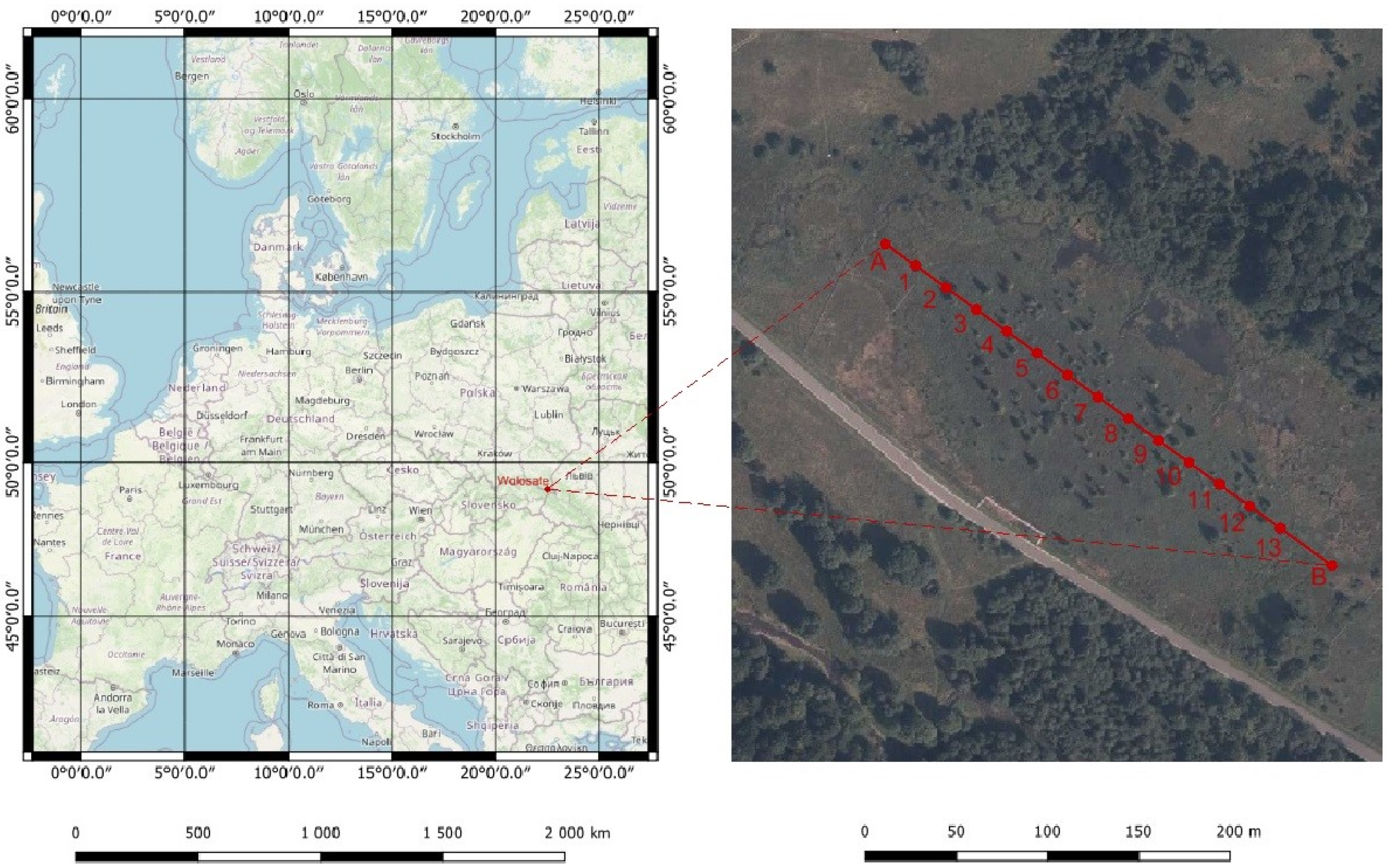
The current area of the peatland reserve is 4.0 ha (from 1959 to 1991, a site of approx. 2.0 ha was a strict nature reserve). Since 1991, the bog in its entirety has been under active protection in the Bieszczady National Park. The location of the “Wołosate” raised bog is shown on a topographic map and an orthophotomap (Figure 1).
A mention of this natural object found its place in a publication by Lisowski [33], while preliminary research for the purposes of record and reference was conducted by Skirgiełło and Rudnicka [34] as well as Marek and Pałczyński [35]. Detailed (stratigraphic and floristic) research in the field of peat science can be found in the works of Lipka and Godziemba-Czyż [36], Lipka [12], Malec [13], Chambers et.al. [37], Chimner et.al [38]. Information on the active protection provided by the Bieszczady National Park was published by Kucharzyk and Szary [39]. It has to be underlined that between 1958 and 1959, rills in the form of exposed patches of peat and significant field hollows were found on the peatland dome surface. Moreover, several drainage ditches were dug through the dome [35]. Studies conducted later [36] found no such irregularities. It is important to note that between 1970 and 1980, the stream valley of the river Wołosatka underwent far-reaching transformations caused by human interference. During this period in Poland, environmental awareness were put aside. As a result of the activities of the Agricultural and Industrial Conglomerate “Igloopol”, the area was dewatered, often with deep open ditches, and drained. In many forested areas, trees were felled, stumps were eliminated from post-agricultural areas using explosives, etc. [13,40]. Even though the bog dome was not completely destroyed, the changes in hydrographic conditions certainly had an adverse effect on the peatland water management. Since 1991, the Bieszczady National Park has been taking steps in order to restore the object. In order to provide that between the dome and the neighboring slope two drainage ponds were organized in order to improve local hydrological conditions. The “Wołosate” nature reserve (4.0 ha) is a raised bog with a characteristically uplifted dome (geographical coordinates: 49°04′49′′ N, 22°39′31′′ E). In terms of water supply, the peatland currently has the soligenous and ombrogenic type of hydrological feeding [11]. It was formed on a high right-side meadow terrace of the Wołosatka stream (680 m ASL), comprised of gravel and pebbles with sand, covered with a clay layer from 0.05 m to 0.30 m thick [11,12,41]. The peatland deposit is mainly composed of bog peat of the Sphagnum type (Ombro-Sphagnoni), cottongrass and Sphagnum species (Eriophoro-Sphagneti), [3]. The formation of the Holocene peat deposit “Wołosate” in stratigraphic terms against the background of hydrological conditions was presented by Lipka and Zając [11].
In 1967, six control wells were established to measure the groundwater level at different times of the year on the research transaction of the Wołosate peat bogs [36]. The average annual level of groundwater at the top of the peat-bog dome was 0.10m, while in the lower parts it reached 0.21 m. At the times of remaining research periods, the average groundwater level was, respectively: 0.28 m (0.10 m–0.48 m)in 1980, 0.35 m (0.12 m–0.57 m) in 1988, 0.21 m (0.00 m–0.42 m) 2016.
A study on the rate of increase in the peatland acrotelm layer was also conducted by Malec [13], who employed the Borggreve’s dendrological method described by Korczagin [42]. The study demonstrated that the annual increments in the acrotelm layer on the “Wołosate” bog were the lowest (3.16–3.90 mm per annum) compared to the Bieszczady Mountain peatlands located in the San River valley (3.99–5.55 mm per annum). A floristic study [43] demonstrated that almost the entire area of the peatland is covered with sphagnous swamp (Sphagnum magellanici), while in the central part of the dome, there occurs a patch of continental marsh species (Ledo-Sphagnum magellanici).
A palynological study on the “Wołosate” bog was also conducted by Ralska-Jasiewiczowa [44,45]. In the process of peat formation, the occurrence of a short phase of marsh spruce and wet leafy forest with Almus glutinosa, followed by the formation of a raised bog, can be observed.
All studies into the rate of peat subsidence on the „Wołosate” bog applied the most up-to-date, precise survey technique. In 1967, the classical angular and linear measurement method was employed. At the same time, the basic, characteristic levelling and stratigraphic cross-section was established [31]. Along the longitudinal cross-section, 12 control points were set out at fixed distances of 20 m, using a precise theodolite and measuring tapes. The last 13th point was set at a distance of 25 m from the point no. 12. Thus, the total length of the tested cross-section was 245 m. Later, the points underwent permanent anchoring in the mineral substrate with appropriate rods. The rods were installed in previously drilled holes, pre-prepared with an “Instore corer”, and then widened with an Edelman soil auger with a diameter ϕ of 10 cm. Values for grand level in the set-out control points were determined based on direct levelling surveys by the geometric technical levelling method with increased accuracy. Referring and controlling the surveys took place in relation to the temporary benchmark located at the abutment of a permanent, reinforced concrete culvert under the regional road No. 897, and directly adjacent to the object under study. In this way, the sub-millimetre accuracy (4–5 mm) of the determined measuring point elevations was obtained.
Subsequent surveys in the years 1980 and 1988 were also carried out by classical land surveying methods. To determine the elevations of the control points (No. 1–13), researchers used geometric levelling method on the examined cross-section in these periods; this lead to obtaining an accuracy of 3–5 mm. The last survey was carried out in 2016 using a modern GNSS (Global Navigation Satellite Systems) satellite technique by the method of kinematic measurements in real time. To this end, a multi-functional active geodetic network established in Poland in the form of ASG-EUPOS system was used. The network is, at the same time, part of the European continental EPN (EUREF Permanent GNSS Network) network and the global IGS (International GNSS Service) network. This approach has offered access to the European Terrestrial Reference System 1989 (ETRS89) which is a standard precise GNSS coordinate system for the whole of Europe. At the same time, ETRS89 provides the basis for geolocation data throughout Europe, both at the national and international level.
The measurements on “Wołosate” raised bog used a multi-system GNSS (GPS + GLONASS + Galileo + BeiDou) receiver, and Trimble R10 satellite set with TSC3 controller. This set, using a support system in the form of terrestrial satellite network ASG-EUPOS, ensured an accuracy of 1 cm in the 3D coordinated determination on the studied object, in the global spatial reference system WGS84 (Word Geodetic System 84). Then, the obtained survey results (WGS84) were transformed to the systems currently valid in Poland i.e., flat coordinate system PL-ETRF2000 and normal height system PL-KRON86.
In this case, elevations of the control points (no. 1–13) on the tested cross-section were determined using the satellite leveling method with an accuracy of 5–6 mm. It has to be taken into consideration that the conducting classical measurements carried out using the geometric levelling method required a lot of hard work in the years 1967–1988. Each time, in order to determine elevations of the controlled points a levelling line from the reference mark had to be established, and one measuring team consisted of at least 3 people. On the contrary, the modern method of satellite levelling applied in 2016 allowed for quick determination of elevations of checkpoints in real time with one GNSS receiver.
Each time, the elevations of the control points on the cross-section were referred to as the level with partially decomposed organic matter in the acrotelm layer.
Taking into account the effect of precipitation on the so-called “pulsation” of the peatland acrotelm layer, monthly lists of precipitation volume observations in the years 1967, 1980, 1988, and 2016, were analyzed, from the meteorological station in Stuposiany located 20 km from the test object. The amount of precipitation in the periods preceding the topographical surveys of the control points ranged from 0.7 to 0.9 mm, therefore they were similar and fell within the precipitation norm as very weak (the classification of daily precipitation according to Olechnowicz-Bobrowska, [46] was adopted). On the other hand, the sum of annual precipitation in the analyzed years was: 1967–950 mm, 1980–1336 mm, 1988–963 mm, 2016–1109 mm and the average annual temperature has increased by 2.23 °C from 7.08 °C in 1967 to 9.31 °C in 2016 [47]. In view of the above, for all study periods, the measurements of the elevation of control points on the cross-section of peatland dome area could disregard the values arising from the pulsation factor. Based on the carried-out measurement, current levelling and stratigraphic cross-section of the bog dome was prepared. To determine the hydrological conditions of the “Wołosate” peat deposit formation, the so-called dynamic curve of the stratigraphic profile i.e., a method proposed by Lipka & Zając [3] was used. A current measurement of the surface area of the bog dome was also made.
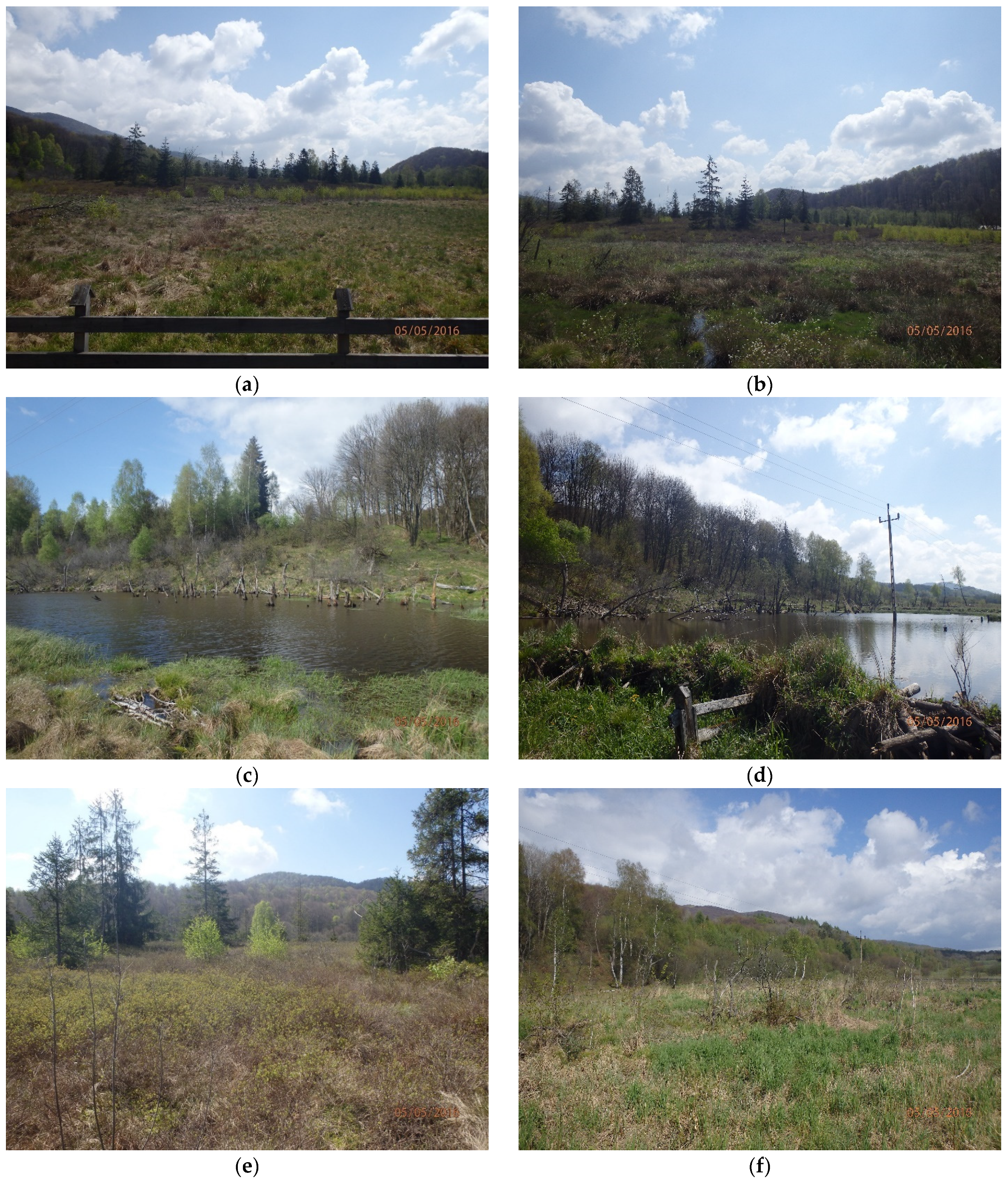
The paper also includes selected photos from the photographic documentation, which present the current condition of the “Wołosate” bog, and the effects of the measures taken as part of its protection provided by the Bieszczady National Park (Figure 2).
The condition of the spruce trees was determined using the four-point Roloff scale, established on the basis of growth phases assessed according to changes in the shape of the tree crown following the growth of branches and their dieback and then breaking off. To assess the vitality of spruces, the bioindication method (degree of defoliation) was applied [48]. The assessment criterion adopted was the percentage of loss in the tree assimilation apparatus (0—to 10 % loss in assimilative apparatus; 1—11–25%; 2—26–60%; 3—over 60 %). In order to objectify and standardize the assessment of degree of crown dieback and defoliation, sets of photos depicting individual degrees of vitality were used [49,50]. The used methodology is in line with the method of studying the impact of anthropogenic pressure on forests, adopted in the United Nations Environment Program.
3. Study Results and Discussion
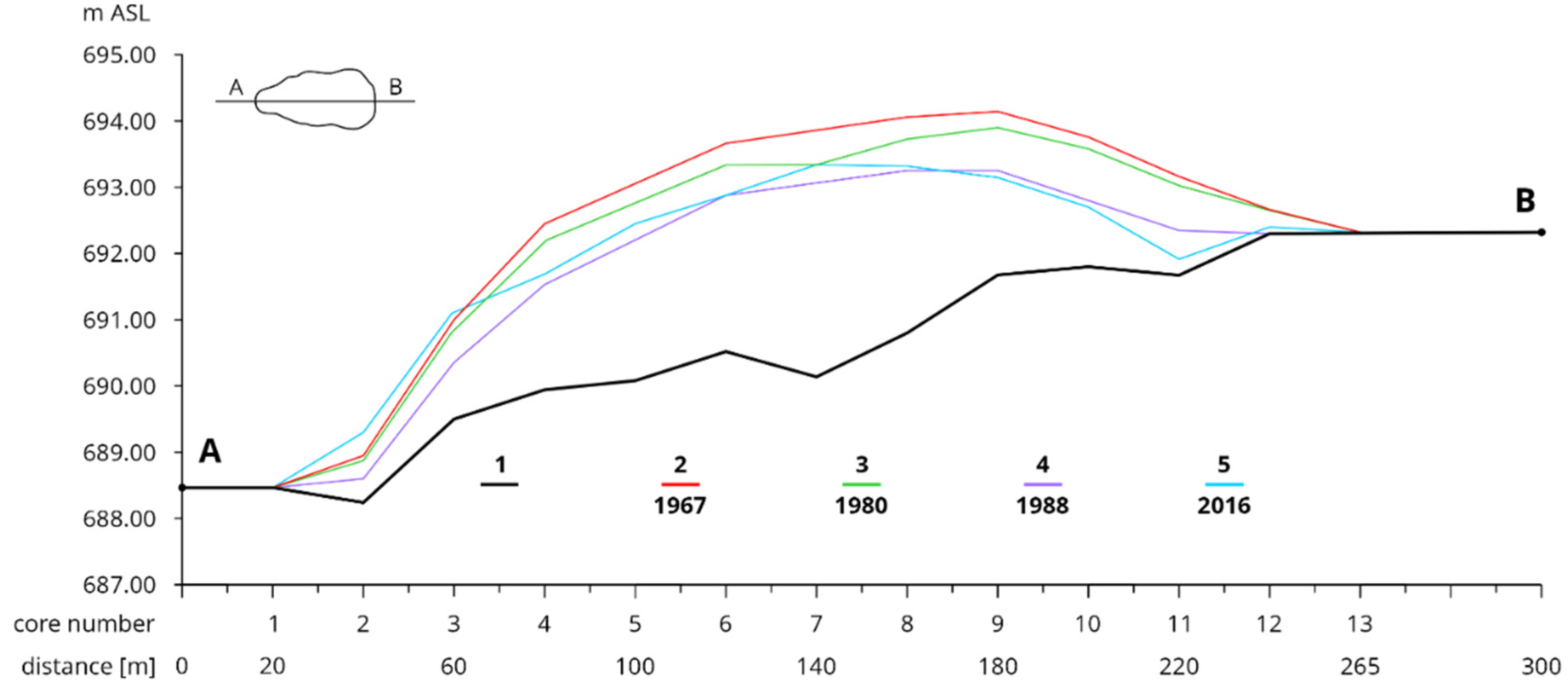
The study demonstrated that the peatland dome has been successively lowering. The data on peat thickness at measuring points on the characteristic stratigraphic A-B transect of the bog dome (a study period of 1967–2016) are presented in Table 1.
The change in the average peat thickness on the A-B transect (Table 1 and Figure 3, in relation to the beginning of the studied period in 1967, is, respectively: 1980 (−10.6%), 1988 (−34.3%), 2016 (−27.2%). Detailed analyses of the data for individual analyzed periods showed that in the years was recorded:
- ▪
- 1967–1980 the average lowering of the peatland area was −0.9 cm/year,
- ▪
- 1980–1988 the average lowering of the peatland surface was −6.5 cm/year,
- ▪
- 1988–2016, the average increase in the peatland surface by +0.6 cm/year.
It follows that the greatest lowering of the peatland surface occurred in 1980–1988 by −6.5 cm/year. Such a rapid subsidence of the peatland surface was caused by the fact that 21 years earlier, the drainage of the entire Wołosatka stream valley had started. However, at the beginning of the 1990s, the Bieszczady National Park began the process of renaturation of the Wołosatka stream valley. As a result, the degradation process of the Wołosate bog was stopped, mainly in its western part, where at the core control points (core number 2–5) an increase in peat thickness from 17 to 78 cm was noted. Changes in peat thickness throughout the analyzed period of 49 years (1967–2016) are also graphically presented on the transect of the peat dome (Figure 3).
It is evident that compared to 1967, changes in the average peat thickness are unfavourable. A higher transect layer can only be observed on the western side, over a length of approx. 50 m. A similar situation occurs on a section of approx. 130 m (the western side) but only in relation to 1988. It can be assumed that this is the effect of restoration measures taken by the Bieszczady National Park.
On the other hand, radically adverse changes took place on the studied transect (along a length of approx. 75 m, on its eastern side); this is illustrated by Table 1 and Figure 3.
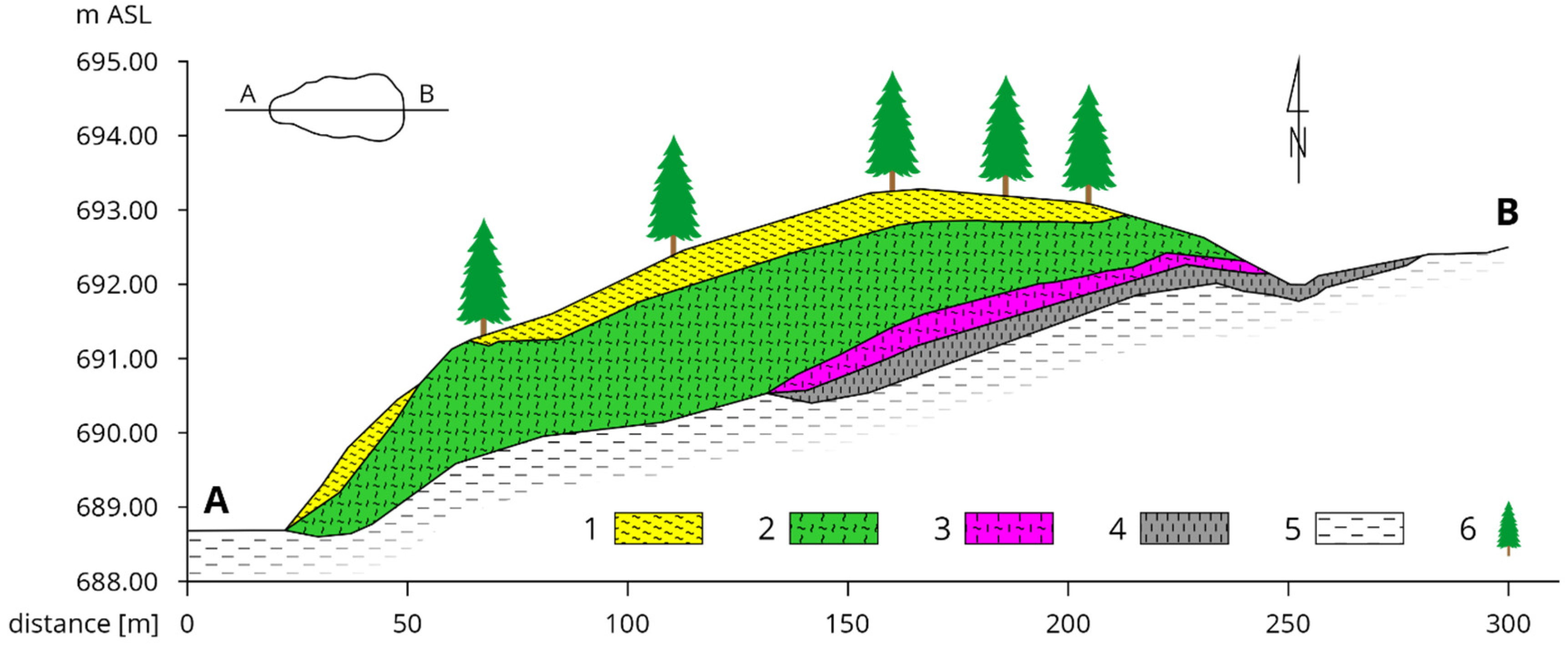
Figure 4 presents characteristic stratigraphic cross-section through “Wołosate” raised bog, developed on the basis of research in 2016 supplemented with data from the works of [12,36].
The dominant factor that affects the stratigraphic structure of peat deposits is the hydrographic conditions, and this changed during the analyzed period. The average annual level of groundwater at the top of the peat dome was 0.10m, while in the lower parts it was 0.21m. In the remaining research periods, the average groundwater level was, respectively: 0.28 m (0.10 m–0.48 m) in 1980, 0.35 m (0.12 m–0.57 m) in 1988, 0.21 m (0.00 m–0.42 m) in 2016.
According to the classification proposed by Lipka and Zając [11], the course of the dynamic curve of the characteristic core transect shows that the Holocene “Wołosate” raised bog was mainly formed under the water management conditions of the ombrogenic nature, along with a progressive rise in the groundwater level, with periodic oscillations of its position. This aquatic environment promoted the accumulation of cottongrass and Sphagnum peat (Eriophoro-Sphagneti), which is the dominant species in the studied peat deposit.
The uppermost layer of the “Wołosate” raised bog dome is mainly comprised of Sphagnum peat (Eusphagneti), which was developing in an ombrogenic aquatic environment but already with a lowering groundwater level. At the same time, the characteristic hummock-hollow complex developed.
On the other hand, on the eastern side, two peat species were distinguished on the clay substrate in the bottom layer (Figure 4). Peat, with a considerable decomposition degree (R > 60%), of the woody type (most probably of the fen peat), as remains of wood and bark (Alnus glutinasa) were found, and of the Sphagnum and sedge (Sphagno-Cariceti) type. In this case, the initial phase of peat formation was affected by short-term river flooding, the permanent groundwater inflow, and the underground flow.
Studies on the vegetation cover carried out on the fen have shown that Ledo-Sphagnetum magellanici occurs in the central part of the fen dome. The moss layer with numerous sphagnum species is very well developed: Sphagnum magellanicum, Sphagnum rubellum, and brown moss, Aulacomnium palustre. The Ledum palustre marsh can also be found. There are also species suitable for the bog forest, such as Vaccinium uliginosum, Vaccinium myrtillus and Picea abies [43,51]. The average age of trees along the A-B transect is about 30 years. The youngest tree is 15 years old, and the scariest tree is 68 years old. The oldest trees occur mainly in the central part of the peat dome. The tallest trees are about 12 m tall and their vitality is 1/2, while the shorter trees (about 1.5 m) have a vitality of 1. Thus, the vitality of young trees decreases.
4. Conclusions
- The conducted research showed that in the years 1967–2016 (over 49 years), the “Wołosate” bog dome was subject to flattening and deformation. The average thickness of peat deposit in the transect under study decreased by 27.2%, while over a period of 21 years i.e., until 1988, decreased by 34.3%. It can therefore be stated that such significant disappearance was mainly contributed to by the human pressure, as the hydrographic conditions changed radically due to the drainage of the Wołosatka stream valley, which resulted in a disturbance of the peatland’s hydrological system.
- The analysis of changes in the profile of the examined transect shows that during the 28 years, i.e., in the years 1988–2016, in the central and western zones of the bog (drilling points: 8, 7, 5, 4, 3, 2), there was an increase in the acrotelm with the Sphagnum layer from 8 to 78 cm. Thus, the peat thickness in the entirely examined A-B transect increased by an average of 15.5 cm. It can be assumed that this is the effect of restoration treatments carried out in this area by the Bieszczady National Park since 1991.
- On the other hand, a further progressive decrease in thickness of the bog on the eastern side (core points no.: 9, 10, 11) indicates that the so-called closed hydrological system of the raised bog fails to function properly. During the last analyzed period (1988–2016), a further decrease from minus 10 cm to minus 45 cm occurred on that area. A reason for this may be the current natural terrain of Wołosatka river valley (lower topographic gradient from the ponds to the eastern sites). It will be visible after some time whether further restoration measures implemented in this area yield adequate results.
- The stratigraphy of the peat deposit under study shows that almost the entire dome interior is filled with bog peat of the Sphagnum type (Ombro-Sphagnioni), the cottongrass and Sphagnum subtype (Eriophoro-Sphagneti), therefore, the accumulation of organic matter during the peat deposit formation took place in the ombrogenic water environment along with the progressive groundwater level rise and periodic oscillations of its position.
- National parks, landscape parks, nature reserves, and ecological sites are the reflection of striving for a return to nature. Numerous peatlands in the Western Bieszczady Mountains in Poland are still preserved in a near-natural condition. It is therefore essential to implement all restoration measures possible where necessary, in order to protect these unique ecosystems. Future work should include comprehensive floristic, hydrological, and peat-science studies, on peatlands in the Bieszczady Mountains in the restoration aspect. This mainly applies to the “Wołosate” bog as it is the most endangered.
Author Contributions
Conceptualization, K.L. and Z.S.; methodology, Z.S.; validation, Z.S.; resources, K.L. and M.S.; data curation, Z.S. and M.S.; writing—original draft preparation, K.L. and M.S.; writing—review and editing, Z.S. and M.S.; visualization, Z.S. and M.S. All authors have read and agreed to the published version of the manuscript.
Funding
This research was created as part of the statutory research of the Department of Land Surveying, University of Agriculture in Kraków, No. 030003-D018.
Institutional Review Board Statement
Not applicable.
Informed Consent Statement
Not applicable.
Data Availability Statement
Not applicable.
Conflicts of Interest
The authors declare no conflict of interest.
References
- Poulin, M.; Andersen, R.; Rochefort, L. A new approach for tracking vegetation change after restoration: A case study with peatlands. Restor. Ecol. 2013, 21, 363–371. [Google Scholar] [CrossRef]
- Wilkinson, S.L.; Moore, P.A.; Flannigan, M.D.; Wotton, B.M.; Waddington, J.M. Did enhanced afforestation cause high severity peat burn in the Fort McMurray Horse River wildfire? Environ. Res. Lett. 2018, 13, 014018. [Google Scholar] [CrossRef]
- Loisel, J.; Gallego-Sala, A. Ecological resilience of restored peatlands to climate change. Commun. Earth Environ. 2022, 3, 208. [Google Scholar] [CrossRef]
- Holden, J.; Evans, M.G.; Burt, T.P.; Horton, M. Impact of land drainage on peatland hydrology. J. Environ. Qual. 2006, 35, 1764–1778. [Google Scholar] [CrossRef]
- Koebsch, F.; Gottschalk, P.; Beyer, F.; Wille, C.; Jurasinski, G.; Sachs, T. The impact of occasional drought periods on vegetation spread and greenhouse gas exchange in rewetted fens. Philos. Transac. R. Soc. B 2020, 375, 1367–1377. [Google Scholar] [CrossRef] [PubMed]
- Gallego-Sala, A.V.; Prentice, I.C. Blanket peat biome endangered by climate change. Nat. Clim. Chang. 2013, 3, 152–155. [Google Scholar] [CrossRef]
- Glenk, K.; Faccioli, M.; Martin-Ortega, J.; Schulze, C.; Potts, J. The opportunity cost of delaying climate action: Peatland restoration and resilience to climate change. Glob. Environ. Chang. 2021, 70, 102323. [Google Scholar] [CrossRef]
- Page, S.E.; Baird, A.J. Peatlands and global change: Response and resilience. Annu. Rev. Environ. Resour. 2016, 41, 35–57. [Google Scholar] [CrossRef]
- Tobolski, K. Torfowiska na przykładzie Ziemi Swieckiej [Peatlands, based on the Example of Świecie Land]; Towarzystwo Przyjaciół Dolnej Wisły: Świecie, Poland, 2003; p. 255. [Google Scholar]
- Zając, E. Proces Samoregeneracji Terenów Poeksploatacyjnych na Torfowiskach w Kotlinie Orawsko-Nowotarskiej [The Process of Post-Mining Area Self-Recovery on Peatlands in the Orawa-Nowy Targ Valley]. Ph.D. Thesis, Department of Soil Reclamation and Peatland Protection, University of Agriculture in Kraków, Kraków, Poland, 2003. [Google Scholar]
- Lipka, K.; Zając, E. Hydrological conditions of peatland formation based on a dynamic curve of a biogenic sediment sequence—A new proposal. J. Water Land Dev. 2018, 37, 75–85. [Google Scholar] [CrossRef]
- Lipka, K. Stratigraphy of peatlands in the Western Bieszczady Mountains. Torfoznawstwo w badaniach naukowych i praktyce [Peat science in scientific research and practice]. IMUZ Falenty 1995, 34, 89–102. [Google Scholar]
- Malec, M. Dynamika Wzrostu Torfowisk wysokich w Bieszczadach Zachodnich [The Dynamics of Raised Bog Increase in the Western Bieszczady Mountains]. Ph.D. Thesis, Department of Soil Reclamation and Peatland Protection, University of Agriculture in Kraków, Kraków, Poland, 2006. [Google Scholar]
- Drewnik, M.; Rajwa-Kuligiewicz, A.; Stolarczyk, M.; Kucharczyk, S.; Żelazny, M. Intra-annual groundwater levels and water temperature patterns in raised bogs affected by human impact in mountain areas in Poland. Sci. Total Environ. 2018, 624, 991–1003. [Google Scholar] [CrossRef] [PubMed]
- Lachacz, A.; Nitkiewicz, M.; Kalisz, B. Water repellency of post-boggy soils with a various content of organic matter. Bilogia 2009, 64, 634–638. [Google Scholar] [CrossRef]
- Holden, J.; Chapman, P.J.; Labadz, J.C. Artificial drainage of peatlands: Hydrological and hydrochemical process and wetland restoration. Prog. Phys. Geogr. 2004, 28, 95–123. [Google Scholar] [CrossRef] [Green Version]
- Ketcheson, S.J.; Price, J.S.; Carey, S.K.; Petrone, R.M.; Mendoza, C.A.; Devito, K.J. Constructing fen peatlands in post-mining oil sands landscapes: Challenges and opportunities from a hydrological perspective. Earth-Sci. Rev. 2016, 161, 130–139. [Google Scholar] [CrossRef]
- Ilnicki, P. Regeneracja torfowisk wysokich [Regeneration of raised bogs]. Biul. Inf. „Torf”/Inf. Bull. “Peat” 1967, 4, 13–26. [Google Scholar]
- Ilnicki, P. Torfowiska i Torf [Peatlands and Peat]; Agricultural Academy in Poznań: Poznań, Poland, 2002; p. 606. ISBN 83-7160-243-X. [Google Scholar]
- Ilnicki, P.; Szajdak, L.W. Zanikanie Torfowisk [The Disappearance of Peatlands]; Poznan Society of Friends of Sciences: Poznań, Poland, 2016; p. 312. ISBN 978-83-7654-374-1. [Google Scholar]
- Lipka, K. Zanikanie torfowisk dawno zmeliorowanych w okolicach Rudnika nad Sanem, Leżajska i Przeworska [The disappearance of previously drainaged peatlands in the vicinity of Rudnik nad Sanem, Leżajsk, and Przeworsk]. Rocz. Nauk. Rol./Ann. Agric. Sci. 1978, 79, 95–127. [Google Scholar]
- Lipka, K. Torfowiska w dorzeczu Wisły jako element środowiska przyrodniczego [Peatlands in the Vistula River basin as a component of the natural environment]. Zesz. Nauk. AR W Krakowie/Sci. J. Agric. Univ. Krakow 2000, 255, 148. [Google Scholar]
- Lipka, K.; Zając, E.; Wdowik, W. Wpływ użytkowania na zanikanie gleb torfowo-murszowych w dolinie rzeki Mrowli koło Rzeszowa [The effect of land use on the disappearance of peat and muck soils in the Mrowla River valley n. Rzeszów]. Zesz. Probl. Postępów Nauk. Rol./Adv. Probl. Issues Agric. Sci. 2005, 507, 349–355. (In Polish) [Google Scholar]
- Lipka, K.; Stabryła, J. Wielofunkcyjność Mokradeł w Polsce i Świecie [Multifunctionality of Marshy Grounds in Poland and Worldwide]. In Wybrane Problemy Ochrony Mokradeł [Selected Issues of Marshy Ground Protection]; University of Warmia and Mazury in Olsztyn, Faculty of Environmental Management and Agriculture: Olsztyn, Poland, 2012; pp. 7–16. [Google Scholar]
- Lipka, K.; Zając, E.; Hlotov, V.; Siejka, Z. Disappearance rate of peatland in Dublany near Lviv (Ukraine) drained in 19th century. Mires Peats 2017, 19, 1–15. [Google Scholar]
- Eggelsmann, R.F. Subsidence of Peatland cost by Drainage Evaporation and Oxidation. In Proceedings of the Third International Symposium on Land Subsidence, Venice, Italy, 19–25 March 1984; Johunson, A., Carbognin, L.I., Ubertini, L., Eds.; JAHS Publication No 151. Institute of Hydrology: Oxfordshire, UK, 1986; pp. 497–505. [Google Scholar]
- Okruszko, H. Wyniki wieloletniego doświadczenia dotyczącego wpływu użytkowania na glebę torfową [Results of a multi-annual experiment on the effects of land use on peat soil]. Wiadomości [IMUZ] 1991, 16, 87–107. (In Polish) [Google Scholar]
- Kasimir-Klemedtsson, A.; Klemedtsson, L.; Berglund, K.; Martikainen, P.; Silvola, J.; Oenema, O. Greenhouse gas emissions from farmed organic soils: A review. Sail Use Manag. 1997, 13, 245–250. [Google Scholar] [CrossRef]
- Deverel, S.J.; Ingram, T.; Leighton, D. Present-day oxidative subsidence of organic soils and mitigation in the Sacramento-San Joaquin Delta, California, USA. Hydrogeol. J. 2016, 24, 569–586. [Google Scholar] [CrossRef] [PubMed] [Green Version]
- Waddington, J.; Rochefort, L.; Campeau, S. Sphagnum production and decomposition in a restored cutover peatland. Wetl. Ecol. Manag. 2003, 11, 85–95. [Google Scholar] [CrossRef]
- Hutchinson, J.N. The record of peat wastage in the East Anglian Fenlands at Holme Post, 1848–1978 AD. J. Ecol. 1980, 68, 229–249. [Google Scholar] [CrossRef]
- Glina, B.; Bogacz, A.; Gulyás, M.; Zawieja, B.; Gajeski, P.; Kaczmarek, Z. The effect of long-term forestry drainage on the current state of peatland soils: A case study from Central Sudetes, SW Poland. Mires Peats 2016, 18, 1–11. [Google Scholar] [CrossRef]
- Lisowski, S. Mchy Bieszczadów Zachodnich [Mosses of the Western Bieszczady Mountains]; Polska Akademia Nauk [Polish Academy of Sciences]: Poznań, Poland, 1956; Volume 93. [Google Scholar]
- Skirgiełło, A.; Rudnicka, W. Dokumentacja Geologiczna torfowiska Ustrzyki Górne (Badania Wstępne). [Geological Documentation of the Ustrzyki Górne Bog (Preliminary Research)]; Zakład Systematyki i Geografii Roślin. Uniwersytet Warszawski [Department of Plant Systematics and Geography, University of Warsaw]: Warsaw, Poland, 1960. [Google Scholar]
- Marek, S.; Pałczyński, A. Torfowiska wysokie w Bieszczadach Zachodnich [Raised bogs in the Western Bieszczady Mountains]. Zesz. Probl. Postępów Nauk. Rol./Probl. J. Adv. Agric. Sci. 1962, 34, 253-3. [Google Scholar]
- Lipka, K.; Godziemba-Czyż, W. Torfowiska i młaki potoku Wołosatka w Bieszczadach Zachodnich [Peatlands and flush mires of the Wołosatka stream in the Western Bieszczady Mountains]. Zesz. Nauk. WSR/Sci. J. Agric. Univ. Kraków 1970, 59, 3–23. [Google Scholar]
- Chambers, F.M.; Beilman, D.W.; Yu, Z. Methods for determining peat humification and for quantifying peat bulk density, organic matter and carbon content for palaeostudies of climate and peatland carbon dynamics. Mires Peats 2011, 7, 1–10. [Google Scholar]
- Chimner, R.A.; Pypker, T.G.; Hribljan, J.A.; Moore, P.A.; Waddington, J.M. Multi-decadal Changes in Water Table Levels Alter Peatland Carbon Cycling. Ecosystems 2016, 20, 1042–1057. [Google Scholar] [CrossRef]
- Kucharzyk, S.; Szary, A. Degradacja i ochrona torfowisk wysokich w Bieszczadzkim Parku Narodowym [Degradation and protection of raised bogs in the Bieszczady National Park]. Rocz. Bieszcz./Res. Educ. Cent. Bieszcz. Natl. Park 2012, 20, 83–97. [Google Scholar]
- Skiba, S. Gleby [Soils]. In Plan Ochrony Bieszczadzkiego Parku Narodowego [The Plan of Protection of the Bieszczady National Park]; Monografie Bieszczadzki, Scientific and Educational Centre of the Bieszczady National Park: Ustrzyki Dolne, Poland, 1996; Volume 2. [Google Scholar]
- Zarzycki, K.; Głowaciński, Z. Bieszczady. Przyroda Polska [Bieszczady. Nature Poland]; Wiedza Powszechna [Common Knowledge]: Warsaw, Poland, 1970; p. 193. [Google Scholar]
- Korczagin, A.A. Oprjedjeljenije wozrasta i dlitjelnosti żizni mchow i pjeczjenocznikow [Determination of the increment and life span of mosses and liverworts]. In Poliewaja Giebotanika; Ławrienko, M., Korczagin, A.A., Eds.; The Russian Academy of Sciences, Institute of Botany: Moscow, Russia, 1960. (In Russian) [Google Scholar]
- Malec, M. Aktualny stan szaty roślinnej trzech wybranych torfowisk wysokich w Bieszczadach Zachodnich. [The current state of plant cover in three selected raised bogs in the Western Bieszczady]. Park. Nar. I Rezerw. Przyrody./Natl. Park. Nat. Reserv. 2007, 26, 33–47. [Google Scholar]
- Ralska-Jasiewiczowa, M. The Forests of the Polish Carpathians in the late Glacial and Holocene; Geomorphology Studies Comatho-Balcamica; Committee on Geographical Sciences, Polish Academy of Sciences: Krakow, Poland, 1972; Volume 6. [Google Scholar]
- Ralska-Jasiewiczowa, M. Late-Glacial and Holocene vegetation of the Bieszczady Mts [Polish Eastern Carpathians]; Institute of Botany, Polish Academy of Sciences PWN: Warsaw-Krakow, Poland, 1980; pp. 3–58. [Google Scholar]
- Olechnowicz-Bobrowska, B. Częstość dni z opadem w Polsce [The Frequency of Days with Precipitation in Poland]; Prace geograficzne; Instytut Geografii PAN [PASc Institute of Geography] PWN: Warsaw, Poland, 1970; Volume 86, p. 75. [Google Scholar]
- Instytut Meteorologii i Gospodarki Wodnej; Państwowy Intytut Badawczy; IMGW. Klimat Polski [Polish Climate]; Institute of Meteorology and Water Management; State Research Institute: Warsaw, Poland, 2021. [Google Scholar]
- Borecki, T.; Keczyński, A. Atlas Ubytku Aparatu Asymilacyjnego Drzew Leśnych [Loss of assimilation Apparatus in Forest Trees Atlas]; ATUT: Warsaw, Poland, 1992. [Google Scholar]
- Kraj, W.; Szewczyk, G.; Zarek, M.; Wąsik, R.; Bednarz, B. Radial growth response of Pinus sylvestris L. and Fagus sylvatica L. to technological solutions applied in rope climbing parks. Dendrochronologia 2022, 76, 126000. [Google Scholar] [CrossRef]
- Cherubini, P.; Battipaglia, G.; Innes, J. Tree vitality and forest health: Can tree-ring stable isotopes be used as indicators? Curr. Rep. 2021, 7, 69–80. [Google Scholar] [CrossRef]
- Malec, M. Dynamika wzrostu wybranych torfowisk wysokich w Bieszczadach Zachodnich [Growth dynamics of selected raised bogs in the Western Bieszczady]. Park. Nar. I Rezerw. Przyr. /Natl. Park. Nat. Reserves 2007, 26, 49–64. [Google Scholar]
Figure 1.
Location of the “Wołosate” raised bog, A-B—transect of the „Wołosate” bog in the Western Bieszczady Mountain. (https://www.google.com/maps/@52.5319205,19.269814,6z?hl=en, accessed on 3 November 2022).
Figure 1.
Location of the “Wołosate” raised bog, A-B—transect of the „Wołosate” bog in the Western Bieszczady Mountain. (https://www.google.com/maps/@52.5319205,19.269814,6z?hl=en, accessed on 3 November 2022).

Figure 2.
The panorama of the “Wołosate” raised bog in the Bieszczady National Park—(a,b); a flood area on the edge of the “Wołosate” raised bog, created as part of protective tasks performed by the Bieszczady National Park in 2016—(c,d); the effect of the drainage of the „Wołosate” bog ecotonal area—2016—(e,f).

Figure 3.
Changes in the longitudinal transect of the “Wołosate” bog dome in the Western Bieszczady Mountain in the years 1967–2016 (1—mineral substrate, 2—the dome surface on 15 May 1967, 3—the dome surface on 12 June 1980, 4—the dome surface on 26 July 1988, 5—the dome surface on 5 May 2016).
Figure 3.
Changes in the longitudinal transect of the “Wołosate” bog dome in the Western Bieszczady Mountain in the years 1967–2016 (1—mineral substrate, 2—the dome surface on 15 May 1967, 3—the dome surface on 12 June 1980, 4—the dome surface on 26 July 1988, 5—the dome surface on 5 May 2016).

Figure 4.
A characteristic stratigraphic A-B transect through the “Wołosate” raised bog (1—Sphagnum peat growing in tufts (Eusphagneti), 2—cottongrass and Sphagnum peat (Eriophoro-Sphagneti), 3—Sphagnum and sedge peat (Sphagno-Cariceti), 4—woody alder peat (Alneti) with degree of decomposition R > 60%, 5—clayey formation, 6—European spruce Picea abies).


Table 1.
Changes in thickness in the characteristic A-B transect of the “Wołosate” bog dome (Western Bieszczady Mountains) in the years 1967–2016.
Table 1.
Changes in thickness in the characteristic A-B transect of the “Wołosate” bog dome (Western Bieszczady Mountains) in the years 1967–2016.
| Core No | Peat thickness (cm) in Subsequent Years | |||
|---|---|---|---|---|
| 1967 | 1980 | 1988 | 2016 | |
| 1 | 0 | 0 | 0 | 0 |
| 2 | 69 | 62 | 37 | 104 |
| 3 | 150 | 135 | 83 | 161 |
| 4 | 250 | 225 | 159 | 176 |
| 5 | 300 | 270 | 219 | 237 |
| 6 | 315 | 283 | 237 | 236 |
| 7 | 370 | 318 | 289 | 319 |
| 8 | 330 | 297 | 248 | 256 |
| 9 | 250 | 225 | 160 | 150 |
| 10 | 195 | 175 | 88 | 87 |
| 11 | 150 | 135 | 69 | 24 |
| 12 | 40 | 36 | 1 | 10 |
| 13 | 0 | 0 | 0 | 0 |
| Average thickness | 219.9 | 196.5 | 144.5 | 160.0 |
Publisher’s Note: MDPI stays neutral with regard to jurisdictional claims in published maps and institutional affiliations. |
© 2022 by the authors. Licensee MDPI, Basel, Switzerland. This article is an open access article distributed under the terms and conditions of the Creative Commons Attribution (CC BY) license (https://creativecommons.org/licenses/by/4.0/).
Share and Cite
MDPI and ACS Style
Lipka, K.; Siejka, Z.; Siejka, M. Peat Thickness Changes at the “Wołosate” Raised Bog in the Western Bieszczady Mountains. Water 2022, 14, 3659. https://doi.org/10.3390/w14223659
AMA Style
Lipka K, Siejka Z, Siejka M. Peat Thickness Changes at the “Wołosate” Raised Bog in the Western Bieszczady Mountains. Water. 2022; 14(22):3659. https://doi.org/10.3390/w14223659
Chicago/Turabian StyleLipka, Krzysztof, Zbigniew Siejka, and Monika Siejka. 2022. "Peat Thickness Changes at the “Wołosate” Raised Bog in the Western Bieszczady Mountains" Water 14, no. 22: 3659. https://doi.org/10.3390/w14223659
Note that from the first issue of 2016, this journal uses article numbers instead of page numbers. See further details here.