1. Introduction
Loess is easy to soften with water, so loess is prone to hydraulic soil erosion [
1]. The Gully Consolidation and Highland Protection (GCHP) project is a large-scale land remediation project based on the unique geomorphology of the Loess Plateau and with the background of soil erosion. The spatial heterogeneity of soil water in its critical zone has important effects on soil erosion, eco-hydrological processes, water–heat–solute transport, and the storage and transport of carbon [
2,
3,
4,
5]. The GCHP engineering governance model lacks scientific and systematic theoretical support because there is no international precedent for reference. Fully understanding the spatial heterogeneity of soil moisture in the critical zone of the GCHP project is theoretically helpful to clarify the soil and water environmental conditions in the critical zone that can lead to geological disasters, such as landslides and debris flows. It also helps to improve and optimize the prediction accuracy of small-scale-distributed hydrological model parameters. It will help to guide and perfect the environmental governance model systematically and scientifically and provide a reference for the ongoing GCHP project measures.
The issue of the spatial distribution of soil moisture has been studied by scholars in loess areas [
6,
7,
8,
9], as soil moisture is the decisive factor in the ecological environment reconstruction in the Loess Plateau [
10,
11,
12]. With the great efforts of many researchers, a relatively complete academic system has been established for the soil moisture spatial heterogeneity in the Loess Plateau since the 1970s. These studies include influences such as soil moisture spatial heterogeneity and vegetation [
13,
14,
15], terrain [
16,
17,
18], land use [
19,
20,
21], loess texture [
22], and studies on the characteristics of soil moisture differentiation including slope [
4,
16], watershed [
23.
24], region [
25,
26], and depth [
20,
27] at different horizontal and vertical spatial scales of the Loess Plateau. Most of these studies focus on vegetation restoration and eco-hydrological process response in the Loess Plateau [
28,
29]. Since 2014, the Qingyang Municipal Government, Gansu Province has made a special deployment of the GCHP project and formulated an overall plan for the protection and management of the highland [
30,
31]. Since the implementation of the GCHP project, the geological disaster effect caused by soil erosion and the eco-hydrological process in the Loess Plateau has changed greatly. To date, there is no international precedent for focusing on GCHP project management. Therefore, the management mode of the GCHP project, the environmental change in soil and water, the engineering measures, and so on, still need to be improved. The scientific reliability of the GCHP project needs further evaluation, which is still an urgent problem to be solved.
Numerous studies have indicated that every process in the Earth’s critical zone has significant spatiotemporal variability characteristics [
32,
33,
34,
35,
36,
37], i.e., the presence of areas or patches in a watershed with high material transport transformation rates. For example, depressions, gully heads, soil interfaces, inter-river zones, and wetlands in river basins often become critical zones (areas or patches with high material transfer and conversion rates in a watershed) for material migration, because of their special hydrological conditions. There are also significant key regional characteristics in the adverse effect of the GCHP project, which means that some areas and landscapes are critical zones prone to geohazard events. Therefore, the study of the adverse effects of the GCHP project can learn from the theory of key areas in Earth’s key belt and promote the progress and development of engineering geology and hydrogeology research [
38,
39,
40]. In this study, Fengbao gully head has undergone GCHP project landfill treatment (i.e., the loess soils from other places were directly transferred, dumped, and compacted), and material migration and transformation are probable in the gully head treatment area and other surrounding areas, so Fengbao gully head can be regarded as the critical area of the GCHP project.
Previous studies pay more attention to ecological measures, and we find that engineering measures are more important in solving the problem of plateau shrinkage. Water is the main culprit in tableland surface erosion. Understanding soil moisture transport after the implementation of soil and water conservation engineering measures is important for the further improvement of the engineering measures. In order to analyze the soil moisture spatial heterogeneity characteristics in the GCHP critical zone, this paper selects the typical gully of the GCHP project—Fengbao gully in Dongzhi plateau—as the study area. In this paper, the soil moisture at different depths in the critical regions of different gully head landfill areas (the loess soil was directly transferred and dumped from other places) is determined, the spatial heterogeneity characteristics and variation rules were studied, and the main soil moisture control factors were analyzed. In deeply understanding the characteristics and laws of the soil and water in the critical zone of disaster (collapse, landslides, and debris flow), the direction of the treatments which can provide a reference for perfecting the GCHP project management system can then be proposed.
2. Study Area
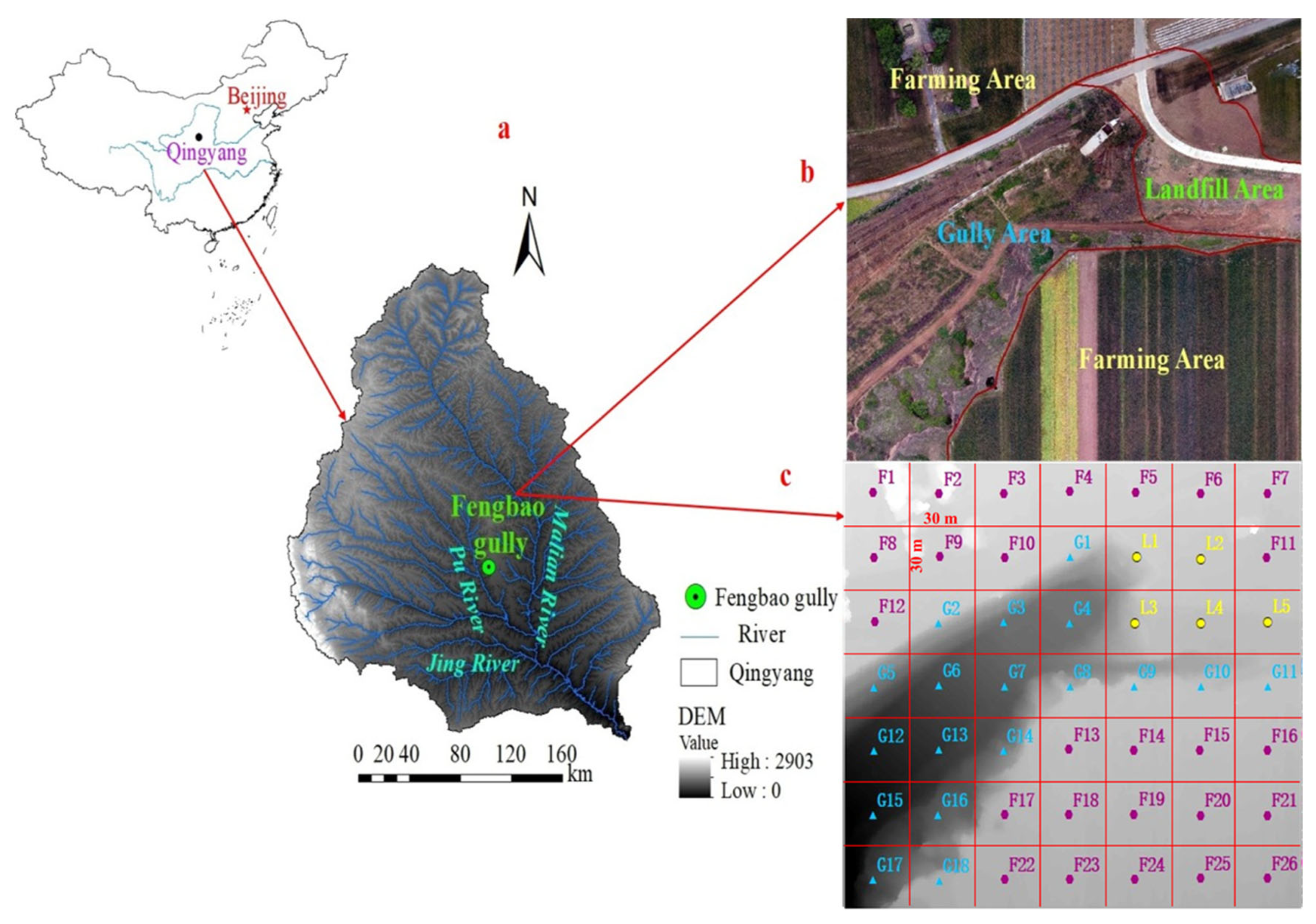
The Dongzhi plateau is located in Qingyang City (107°27′42″–107°52′48″ E, 35°25′55″–35°51′11″ N), eastern Gansu Province which has the largest plateau area, the most complete preservation, and the thickest loess sedimentation in the world (
Figure 1a). It covers a total area of 812 km
2, accounting for 3.3% of the total area of Qingyang City, involving 21 towns. The Fengbao gully is located southwest of Dongzhi Town (Fengbao Village) in Xifeng District, about 500 m south of Fengbao Street. Before the comprehensive control of the GCHP project in the Fengbao gully, after the widening of Dongzhi Street and the existing drainage project that could not meet the drainage requirements, the runoff increased and resulted in serious erosion damage at the gully head. Water erosion cut down the gully at the outlet. There is little vegetation, and the ecology was fragile on the slopes. In 2015, the Qingyang Water Conservation Bureau implemented the GCHP for 37 large highlands in Qingyang City, with a planned area of 3095.87 km
2, and 118 gully heads were rescued under control. Among them, the Fengbao gully head has set concrete protection of 380 m. An area of 2.2 hm
2 of abandoned housing land was reclaimed to the north of the gully head. A volume of 105,800 m
3 of hillside slope was cut, 105,800 m
3 of backfill earthwork was finished, 63,500 m
3 of masonry revetment was laid, and 15,000 trees were planted. Willows were planted in a 1.6 hm
2 area of the gully bottom and 18.5 hm
2 of arbor forests were planted on the slope. The Fengbao gully head area is divided into three parts: gully head landfill, highland farming, and gully area. This study selects the 210 m × 210 m area in the Fengbao gully head area, among which the above three parts were uniformly covered, to study the spatial heterogeneity of soil moisture in the critical zone of the GCHP. The vegetation remained unchanged in the valley area and the highland farmland area beside the tableland, but in the landfill area, the vegetation changed from herbaceous to bare soil before and after the gully head landfill and recovered from bare soil to herbaceous after a period of continuous growth.
3. Method and Data
3.1. Sampling Method
During the sampling period, the vegetation in the gully head landfill area and gully area was herbaceous; the vegetation in the highland farming area was mainly winter wheat. There was no irrigation process in the farming area, and the soil was fertile. The average slope and elevation of the valley were 30.5° and 1353.19 m, respectively. The organic matter, density, porosity, and hydraulic conductivity of soil were 24.01 g/kg, 1.47 g/cm
3, 0.533 and 0.15 m/d, respectively [
41,
42,
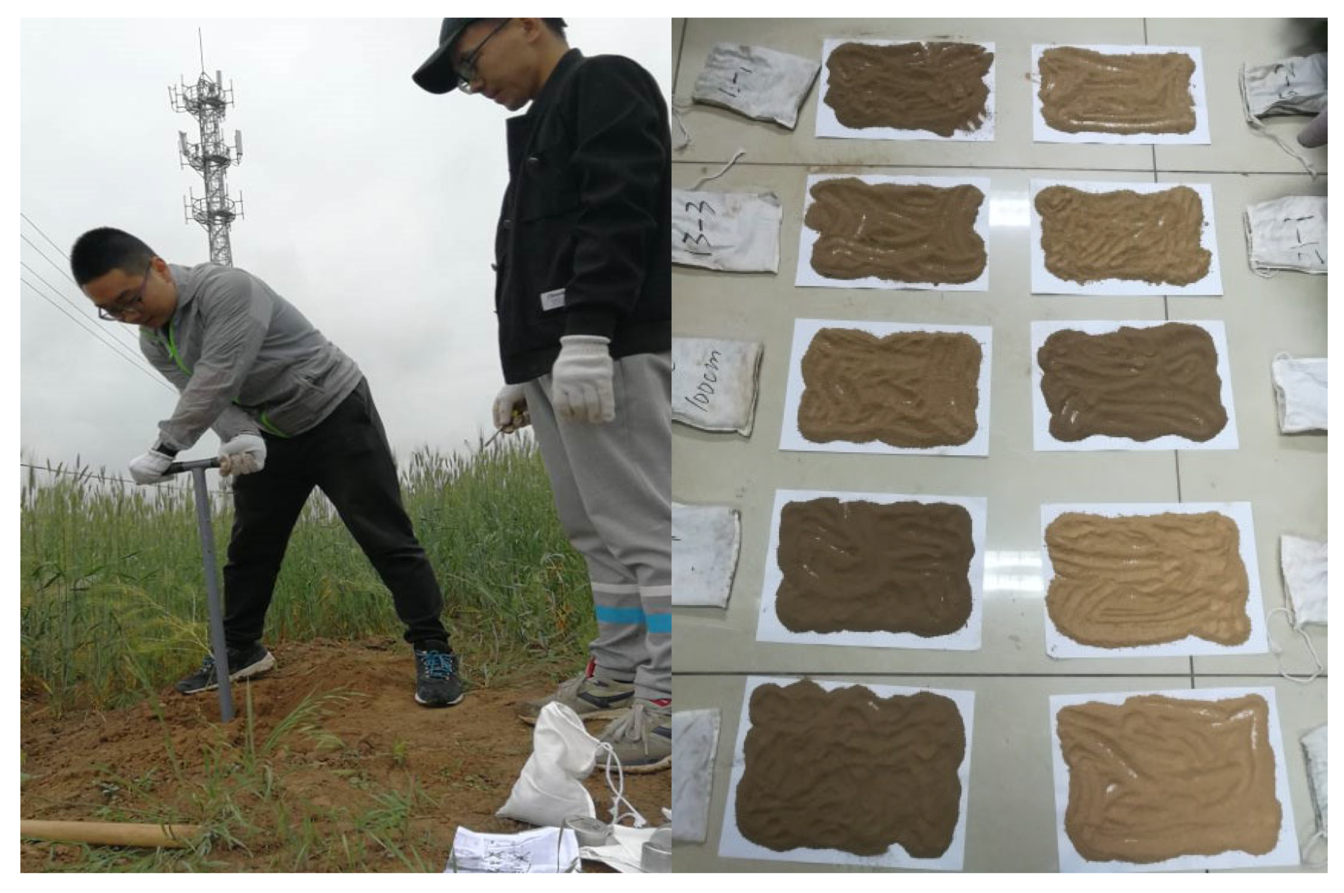
43]. A soil drill with a maximum length of 5 m was used for laboratory manual sampling. Soil samples were weighed in the field, wrapped in cling film and sealed with tape, and placed in an aluminum box before being brought back to the laboratory for statistical and analytical purposes.
In this study, a total of 375 remote sensing images were captured by the drone (Phantom 4 RTK, DJ-Innovations, Xi’an, China) around the Fengbao gully head area in eastern Gansu Province between 11–15 May 2018 (
Figure 1a). Photoscan software (V1.4.5) was used to generate 210 m × 210 m orthophoto image and DEM, and then ArcGIS 10.2 software was used to overlay 30 m × 30 m grid layer on DEM. The center of each grid was determined as the sample point (
Figure 1c). Sampling was conducted at the end of May 2019. Since soil moisture (especially topsoil moisture) is closely related to rainfall, the results obtained from sampling in different seasons (especially before and after the rainy season) may vary significantly. Therefore, the results of this experiment were controlled before the rainy season in order to reduce the influence of seasonal rainfall on the study results. A 5 cm diameter soil drill (DIK-1815, Labcan Scientific, Shanghai, China) was used as the tool. The soil samples were collected from 0 cm (the surface soil) to 200 cm in depth at an interval of 50 cm (sampling was repeated three times at each point to reduce errors). The total number of roots in the 0–50 cm soil layer accounted for more than 90%, while that in the 50–200 cm soil layer was less than 10% (Li et al., 1992). Therefore, we chose a sampling depth of 200 cm. In addition, to determine the physical and chemical properties of the soil in the area, six mixed samples (mixing the soil from different depths at the sampling sites, see
Figure 2) were selected by another random sampling of different areas. Pretreatment (such as an air-drying method) was carried out before testing.
There were 49 sample points in the study area. Sampling points G18, L5 and F26 correspond to and represented 18 gully consolidation landfill sample points, 5 highland farming sample points, and 26 gully area sample points, respectively. Because there were no other interferences around these points (such as plants, channels, and buildings), the soil’s physical and chemical properties in these three areas were analyzed by testing the physical and chemical properties of the representative G18, L5, and F26 sample points.
At present, the GCHP includes all of these three zones (divided from the plane zone). The gully area is formed by natural water erosion and is the foundation of the GCHP project; the gully head area is the key area, namely, the gully head landfill area; the highland farming area is the surrounding natural environment for the implementation of the GCHP project, and it is also the basis for studying whether the GCHP project can continue to play a role.
3.2. Soil Moisture and Particle Size Distribution Determination
The soil moisture measurements were based on a national standard (GB7172-87). The soil particle size distribution was determined using a laser diffraction size analyzer (Mastersizer 2000, Malvern Instruments Limited, Worcestershire, England, UK).
Table 1 shows the main characteristics of the sampling numbers in different areas (gully head landfill, gully area, and highland farming area). Statistical characteristics (including the
t-test and normality test) for the soil moisture data at different depths were conducted using Excel 2010 and SPSS 13.0 (
Table 2). The geospatial analysis was based on regionalized variables and random functions, with semi-covariance functions as the basic tool. This included the statistical analysis of sample data, the rejection of outliers, the calculation of variance functions, the structural analysis of variance functions, the optimal fitting and testing of the theoretical variance function model, and the application of the Kriging interpolation method to generate a soil moisture distribution map for the entire study area by interpolating the soil moisture condition of the unmeasured areas based on the theoretical variance function model.
The different sampling depths reflect the influence depth of the GCHP project (from the longitudinal direction). For example, soil moisture affects the shear strength of the soil at the foot of the slope which can easily induce geological disasters such as collapse, landslide, and mud flow. All of these have a great influence on the sustainability of the GCHP project.
4. Results and Analysis
4.1. Statistical Characteristic Analysis of Soil Moisture Description at Different Depths
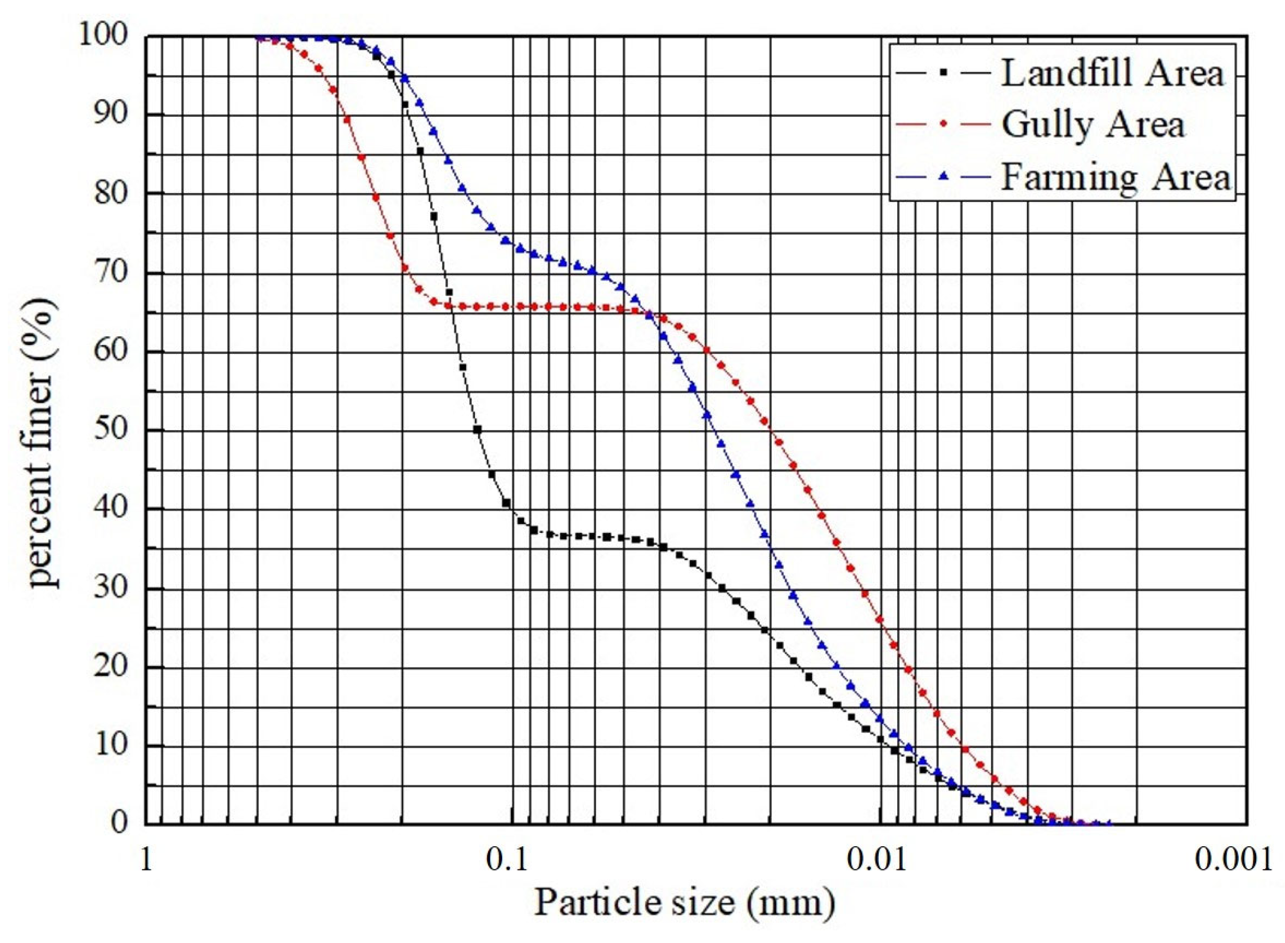
In
Figure 3, the black curve is the soil particle grade distribution curve in the gully head landfill area, the blue curve represents the highland farming area, and the red curve represents the gully area. It can be seen that the sand content is the highest and the silt and clay are low in the gully head landfill area. The difference between the highland farming area and the gully area is not huge, and there is a cross phenomenon at a particle size of around 0.05 mm. The main reason for this phenomenon is that the two areas have less artificial disturbance, which belongs to undisturbed soil. However, the gully landfill area has a great artificial disturbance which generally belongs to the uncompacted backfill soil without any vegetation cover. The studies of Peng et al. [
45] and Feng et al. [
46] both showed that the gully head backfill completely changed the original hydrogeological structure of the construction area and reconstructed the hydrological cycle pattern of the site, and also makes the structure and soil characteristics of the permeable medium completely different from the original loess. Zhuang et al. [
47] found through experiments that sandy soil with high shear strength and high permeability can enhance the effective stress of soil, which is the same as the results of this paper. As for the effect of soil texture on soil moisture, many studies have proved that soil moisture is negatively correlated with sand content, and silt particles are positively correlated with clay grains under the same conditions [
27,
48], which is consistent with the results in this paper.
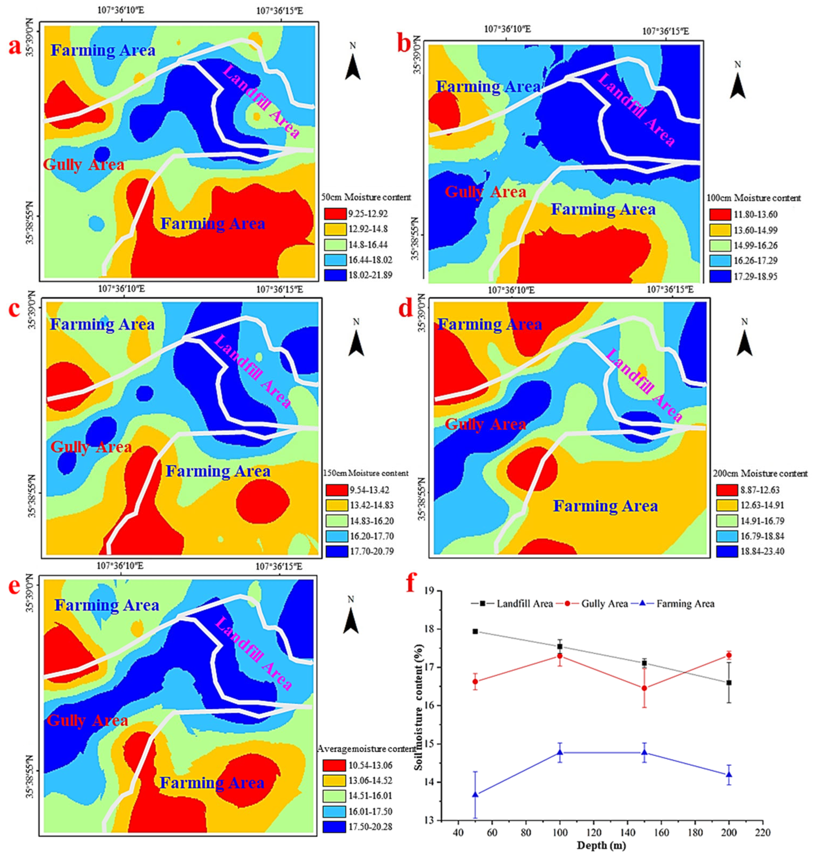
Table 2 shows the basic statistical characteristic values of soil moisture at different sampling depths in the Fengbao gully head landfill area, gully area, and highland farming area. As can be seen from
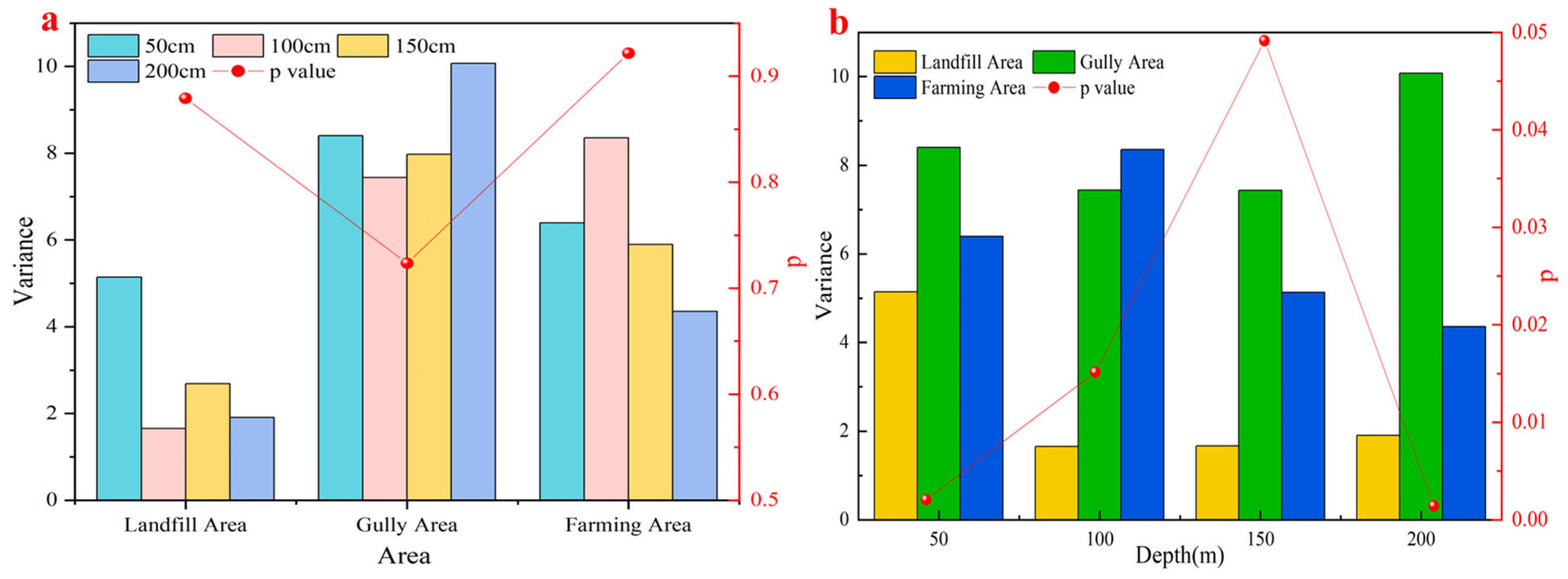
Table 2, the order of average soil moisture in the different areas is gully head landfill area (17.80%) > gully area (16.65%) > highland farming area (14.40%). According to
Figure 4, it can be concluded that there is no significant difference between different depths in the same area since all
p are greater than 0.05. Whereas
p is less than 0.05 between the same depth in different areas, therefore there is a significant difference. The average soil moisture values vary significantly, which may be due to the differences in vegetation, topography, soil texture, and so on (
Figure 3) [
49]. The landfilling area and farmland area are relatively flat, and the terrain of the gully area is relatively low and fluctuates greatly. Compared with undisturbed natural soil, landfilling soil was manually compacted, and the porosity and consolidation degree (structure) are still quite different [
50]. The spatial heterogeneity for soil moisture in the critical area was significantly affected by the differences in vegetation and soil texture in the gully head landfill area, the gully area, and the highland farming area.
According to
Table 2, we can find the regional characteristics of the spatial differentiation in soil moisture. By analyzing this feature, we can find the key weak area of the GCHP project, that is, the areas with a large soil moisture content. The loess soil is very strong when the water content is small, and it will become soft only when the soil moisture is high, to a certain extent (it is a characteristic of loess itself that loess combined with water is soft). The analysis of this feature can point out the direction for the sustainable development of the GCHP project.
4.2. Analysis of the Spatial Distribution of Soil Moisture
The bar graph in
Figure 5 shows the average soil moisture at different depths in different regions in the Fengbao gully head area: gully head landfill area > gully area> highland farming area. The standard errors of soil moisture at 50 cm, 100 cm, 150 cm, and 200 cm depths were 1.79, 1.26, 0.98, and 1.35, respectively. The highest, lowest, and average altitudes of the gully area are 1416.65 m, 1322.34 m, and 1353.19 m, respectively. The main reason is that the gully head landfill area and the gully area are generally located in a low-terrain region of the watershed. Rain runoff is gathered here and the basic soil water content is high. In addition, the soil in the gully head landfill area is backfill composed of compacted soil, and the surface is not covered with any vegetation after landfilling. The natural loess porosity and soil water holding capacity are 0.53 and 19.6%, respectively (Liu and Dong 1997). In the highland farming area, the soil moisture decreases continuously with the sampling depth in the range of 0–200 cm. Compared to the original loess in the gully area, the soil’s physical properties (e.g., porosity) change, and the growth of sporadic shrubs in the gully area can consume soil water. The average soil moisture at each depth in the farming area is significantly lower than that in the gully head landfill and the gully area. The main reason for this is that the sampling period was at the time when the local autumn wheat was about to mature and the wheat in the farming area had a high degree of coverage. The soil moisture in the gully head landfill area increased with an increase in depth from 50–100 cm, and then decreased with an increase in depth in the range from 100–200 cm; The soil moisture in the gully area increased with depth in the range of 50–100 cm, decreased with depth in the range of 100–150 cm, and increased again in the range of 150–200 cm. This was because the Loess Plateau receives strong solar radiation and the surface soil moisture at 50 cm depth is easily affected [
51], which leads to the obvious spatial differentiation in surface soil water. For the gully head treatment area, the depth of 100 cm is usually the maximum depth for normal rainwater infiltration (without a dominant channel); in the gully area, the root system of vegetation mostly existed in the depth range of 100–150 cm [
44], and the vegetation growth consumption of soil water results in the decrease in soil moisture in this range. The soil moisture in the depth range of 150–200 cm may rise again due to the existence of a clay layer (The clay content of the mild clay layer is between 10% and 30%. In the gully area, the soil clay content was 16.81% [
52]); the soil moisture in the highland farming area of the tableland is mainly affected by the vegetation (autumn wheat). Therefore, soil moisture decreases continuously with depth below the surface.
5. Discussion
Hydraulic erosion and the GCHP project are mutually affected. On the one hand, hydraulic erosion exacerbates soil loss; on the other hand, the purpose of the GCHP project is to reduce soil loss. At present, the GCHP project is mainly implemented in the gully head area which is the critical zone of hydraulic erosion. The gully head area is divided into the gully head landfill area, the gully area, and the highland farming area. This study found that the soil moisture in the gully head landfill area, the main flow pathway, is higher than that in other areas. Therefore, this study can provide technical support for a large-scale GCHP project that is being carried out under the background of unique geomorphic characteristics in the Chinese Loess Plateau.
Soil water is concentrated in the gully head landfill area in this subbasin because the GCHP landfill area is located in the gully head area. This is usually the lowest location in the entire watershed, where the rainfall and runoff in the subbasin collect; the aeration zone of water in the soil is also gathered here, which is also often the outlet for groundwater. The soil sand content in the gully head landfill area is larger than in the other two regions. According to the general theory, the soil moisture in soil with a large sand content should decrease under the same conditions. While the soil moisture in this area has increased, this proves that the gully head landfill area is the collecting location of surface runoff, aeration zone water, and groundwater from other lands. Dynamic water is the main inducer of many geological disasters, such as mudslides, collapse, landslides, and so on (Mu et al., 2016; Peng et al., 2008; Peng et al., 2014), so the spatial distribution of soil moisture can indicate the direction of monitoring, prevention, and treatment for the GCHP.
Many studies have been made from the scientific perspective of soil and water conservation in the past, but research on the adverse effects of loess erosion under the background of severe human intervention is still rare. The strength of loess structure is closely related to soil moisture [
53] and loess cohesion will drop sharply because of high soil moisture, which will be easily collapsible. From the aspect that soil moisture and sand content are negatively correlated (correlation coefficient = −0.84), soil moisture is positively correlated with clay content (correlation coefficient = 0.73) under the same conditions, this study being consistent with previous studies (Suo et al., 2017; Wang et al., 2016). The soil moisture results suggest that the GCHP project should strengthen the subsequent management measures of the gully head backfilling to prevent landslides, collapses, and other secondary geological disasters from occurring.
Although the predecessors have done a lot of research work in this field, the research on a multi-spatiotemporal scale is not sufficient. Future research should emphasize the influence of the GCHP under the background of loess erosion at multiple spatial and temporal scales. Particular attention should be paid to the critical zone at the head of the gully, and good drainage measures to reduce soil erosion and secondary geological hazards will be the direction of future research. It is urgent to set up long-term positioning monitoring points in the critical gully head zone to monitor the soil moisture and soil erosion status in real time. Based on the concept of Earth’s critical zone science, the scientific control theories and the technical system of disaster prevention for the GCHP project based on multiple spatiotemporal scales are proposed, which can help the implementation of the “Belt and Road” major strategy in China.
The limitation of this study was that the sampling depth did not reach the bottom of the gully, and the effect of soil water on the GCHP will be better understood if the groundwater level can be reached. Further study, which should focus on improving the estimation accuracy of soil moisture, should use a more advanced soil drill to take soil samples from deeper soil layers.
6. Conclusions
In order to explore the impact of the GCHP project on the soil and water environment in the zones of the gully head landfill area, the soil moisture at 0–200 cm depths in the Fengbao gully head in Xifeng district, Qingyang City and the soil texture in different regions were observed and analyzed. The results showed that:
- (1)
The implementation area of the GCHP project includes the gully head landfill, the gully, and the highland farming area. Soil moisture is heterogeneous in the three regions. In the typical loess highland of the gully–Fengbao gully head area, the average soil moisture at different depths in different areas is shown basically as follows: gully head landfill area> gully area > highland farming area. This characteristic shows that the implementation of the GCHP project has a large impact on the soil and water environment in the gully head landfill area which is located on the flow path, and the soil moisture here is significantly higher than that of the other two areas.
- (2)
The soil sand content in the gully head landfill area is higher than that in the gully area and the highland farming area, while the slit and clay here are lower than in the other two areas. Soil moisture is negatively correlated with sand content, and it is positively correlated with clay and silt particles. The variation in soil moisture in the three regions is obvious. The variation coefficient in depths less than 50 cm was the largest since there are many disturbance factors (such as in highland farming areas) that exist near the ground surface. Compared to the gully and the highland farming area, the mean variation coefficient (9.52%) was the smallest in the gully head landfill area. This was because there was usually no vegetation cover on the surface of the backfill soil in the gully head area, and so the influencing factors were mainly related to the soil texture.
Soil moisture that is too high can reduce the shear strength of loess and induce secondary geological disasters. Therefore, it is suggested that the vegetation coverage in the gully head area should be improved after backfilling in the later stage of the GCHP project. It is helpful to reduce the development of secondary geological disasters.
Author Contributions
Conceptualization, A.H. and Z.Z.; methodology, A.H. and J.P.; software, Z.Z. and P.L.; investigation, A.H., Z.Z., P.L. and C.Z.; resources, A.H. and J.P.; data curation, Z.Z. and P.L.; writing—original draft preparation, A.H. and Z.Z.; writing—review and editing, M.E.-S.A.; project administration, C.Z. and J.P.; funding acquisition, A.H. All authors have read and agreed to the published version of the manuscript.
Funding
This research was funded by the National Natural Science Foundation of China [Grants No. 41790444 and 41877232]; High-tech research cultivation project CHD [Grants No. 300102299201 and 300102299302]; National Key R&D Program of China [2018YFE0103800]; Key R & D projects of Shaanxi Province [Grants No. 2020SF-424]; International Collaborative Research of Disaster Prevention Research Institute of Kyoto University [2019W-02]; Excellent projects for science and technology activities of overseas staff in Shaanxi Province [2018038]; Key Laboratory Open Project Fund of State Key Laboratory of Loess and Quaternary Geology, Institute of Earth Environment, CAS [Grants No. SKLLQG1909).
Conflicts of Interest
The authors declare no conflict of interest.
References
- Li, Y.R.; Shi, W.H.; Aydin, A.; Beroya-Eitner, M.A.; Gao, G.H. Loess genesis and worldwide distribution. Earth-Sci. Rev. 2020, 201, 102947. [Google Scholar] [CrossRef]
- Lei, Z.; Hu, H.; Yang, S. A Review of Soil Water Research. Adv. Water Sci. 1999, 10, 311–318, (In Chinese with English Abstract). [Google Scholar]
- Liu, G.B.; Li, M.; Shangguan, Z.P.; Mu, X.M.; Xie, Y.S.; Li, Z.B.; Hang, Y.L.; Zhang, W.H.; Hou, Q.C. Current status and comprehensive control strategies of soil erosion for loess region in the Northwestern China. Sci. Soil Water Conserv. 2008, 6, 16–21. [Google Scholar]
- Wang, Y.; Zhang, X.; Cong, W.; Wei, Q. Spatial variability of soil moisture on slope-land under different land uses on the Loess Plateau. J. Agric. Eng. 2006, 22, 65–71, (In Chinese with English Abstract). [Google Scholar]
- Yao, W.Y.; Li, Z.B.; Kang, L.L. Ecological and Environmental Effects of soil Erosion Control on the Loess Plateau; Science Press: Beijing, China, 2005. [Google Scholar]
- Qiao, J.; Zhu, Y.; Jia, X.; Huang, L.; Shao, M.A. Factors that Influence the Vertical Distribution of Soil Water Content in the Critical Zone on the Loess Plateau, China. Vadose Zone J. 2018, 17, 1–7. [Google Scholar] [CrossRef]
- Wang, Y.; Liu, Z. Vertical distribution and influencing factors of soil water content within 21-m profile on the Chinese Loess Plateau. Geoderma 2013, 193, 300–310. [Google Scholar] [CrossRef]
- Yu, Y.; Wei, W.; Chen, L.; Feng, T.; Daryanto, S.; Wang, L. Land preparation and vegetation type jointly determine soil conditions after long-term land stabilization measures in a typical hilly catchment, Loess Plateau of China. J. Soils Sediments 2017, 17, 144–156. [Google Scholar] [CrossRef]
- Zhao, W.; Fang, X.; Daryanto, S.; Zhang, X. Factors influencing soil moisture in the Loess Plateau, China: A review. Earth Environ. Sci. Trans. R. Soc. Edinb. 2019, 109, 501–509. [Google Scholar] [CrossRef]
- Huo, A.; Huang, Z.; Cheng, Y.; Van Liew, M.W. Comparison of two different approaches for sensitivity analysis in Heihe River basin (China). Water Supply 2020, 20, 319–327. [Google Scholar] [CrossRef]
- Liu, D.; An, Z.; Yuan, B. Eolian process and dust mantle(loess) in China. Quat. Sci. 1985, 6, 113–125, (In Chinese with English Abstract). [Google Scholar]
- Liu, D.; Sun, J.; Wu, W. The History, Current Situation and Future of Chinese Loess Research—A Discussion Combining Facts and Stories. Quat. Sci. 2001, 21, 185–207, (In Chinese with English Abstract). [Google Scholar]
- Hu, L.; Shao, M.; Yang, W. Relationship between vegetation spatial collocations and soil moisture spatial heterogeneities in the Loess Plateau area. Acta Prataculturae Sin. 2004, 13, 14–20, (In Chinese with English Abstract). [Google Scholar]
- Liu, Z.; Wang, Y. Study on Transpiration Water Consumption of Artificial Chinese Pine Forest and Water Dynamic Characteristics. Bull. Soil Water Conserv. 1990, 6, 78–84, (In Chinese with English Abstract). [Google Scholar]
- Wang, M.; Li, H. Study on Transpiration Status and Soil Moisture Dynamics of Caragana korshinskii Kom. Bull. Soil Water Conserv. 1990, 6, 85–90, (In Chinese with English Abstract). [Google Scholar]
- Hu, W.; Shao, M.; Wang, Q. Study on spatial variability of soil moisture on the recultivated slope-land on the Loess Plateau. Adv. Water Sci. 2006, 17, 74–81, (In Chinese with English Abstract). [Google Scholar]
- Li, Y.; Shao, M.; Zhang, X. Spatial distribution of soil moisture and available phosphorus content on eroded solping land. J. Soil Water Conserv. 2001, 15, 41–44, (In Chinese with English Abstract). [Google Scholar]
- Xu, X.; Liu, W.; Gao, P.; Wu, X. The discussion on soil moisture distributional diversity in hilly Loess Plateau region. Ecol. Environ. Sci. 2003, 12, 52–55, (In Chinese with English Abstract). [Google Scholar]
- Li, X.; Lei, T.; Wang, W. Spatial variability and fractal dimension of soil property in field. Agric. Res. Arid Areas 2000, 18, 61–65, (In Chinese with English Abstract). [Google Scholar]
- Wang, Y.; Shao, M.; Liu, Z. Spatial variability of soil moisture at a regional scale in the Loess Plateau. Adv. Water Sci. 2012, 23, 310–316, (In Chinese with English Abstract). [Google Scholar]
- Zhu, S.; Ding, Y.; Xue, T. Study on Spatial Variability and Timporal Stability of Soil Moisture in Agro-forestry. Res. Soil WaterConserv. 2000, 7, 46–48, (In Chinese with English Abstract). [Google Scholar]
- Jiao, R.; Zhao, Y.; Si, B.; Lan, Z.; Zhang, J. Effects of conversion of cropland to forest measures on deep soil moisture in Loess Plateau. Agric. Res. Arid Areas 2017, 35, 135, (In Chinese with English Abstract). [Google Scholar]
- Mu, D.; Luo, P.; Lyu, J.; Zhou, M.; Huo, A.; Duan, W.; Nover, D.; He, B.; Zhao, X. Impact of temporal rainfall patterns on flash floods in Hue City, Vietnam. J. Flood Risk Manag. 2020, 14, e12668. [Google Scholar] [CrossRef]
- Zhang, X.; Feng, X.; Zhao, C. GIS-assisted Modeling of Temporal and Spatial Distribution of Soil Water Content in Loess Plateau—A Case Study in Anjiagou Catchment. J. Nat. Resour. 2005, 20, 132–139. [Google Scholar]
- Jia, X.; Shao, M.; Zhang, C.; Zhao, C. Variation and simulation of soil water content within different soil depths along the south-north transect of the Loess Plateau. Adv. Water Sci. 2016, 27, 520–528. [Google Scholar]
- Zhang, Y.; Luo, P.; Zhao, S.; Kang, S.; Wang, P.; Zhou, M.; Lyu, J. Control and Remediation Methods for Eutrophic Lakes in Recent 30 years. Water Sci. Technol. 2020, 81, 1099–1113. [Google Scholar] [CrossRef] [PubMed]
- Wang, Y.; Shao, M.; Hu, W.; Lin, H.; Huang, H. Spatial Variations of Soil Water Content in the Critical Zone of the Chinese Loess Plateau. Earth Environ. 2016, 44, 391–397, (In Chinese with English Abstract). [Google Scholar]
- Luo, P.; Kang, S.; Apip; Zhou, M.; Lyu, J.; Aisyah, S.; Binaya, M.; Regmi, R.K.; Nover, D. Water quality trend assessment in Jakarta: A rapidly growing Asian megacity. PLoS ONE 2019, 14, e0219009. [Google Scholar] [CrossRef] [Green Version]
- Luo, P.; Sun, Y.; Wang, S.; Wang, S.; Lyu, J.; Zhou, M.; Nakagami, K.; Takara, K.; Nover, D. Historical Assessment and Future Sustainability Challenges of Egyptian Water Resources Management. J. Clean. Prod. 2020, 263, 121154. [Google Scholar] [CrossRef]
- Huo, A.; Peng, J.; Chen, X.; Deng, L.; Wang, G.; Cheng, Y. Groundwater storage and depletion trends in the Loess areas of China. Environ. Earth Sci. 2016, 75, 1167. [Google Scholar] [CrossRef]
- Huo, A.; Peng, J.; Cheng, Y.; Zheng, X.; Wen, Y. Temporal Characteristics of the Rainfall Induced Landslides in the Chinese Loess Plateau (China): IEREK Interdisciplinary Series for Sustainable Development. In Conference of the Arabian Journal of Geosciences; Springer: Cham, Switzerland, 2019; pp. 425–427. [Google Scholar] [CrossRef]
- Brantley, S.L.; McDowell, W.H.; Dietrich, W.E.; White, T.S. Designing a network of critical zone observatories to explore the living skin of the terrestrial Earth. Earth Surf. Dyn. Discuss 2017, 5, 841–860. [Google Scholar] [CrossRef] [Green Version]
- Bryan, R.B. The influence of some soil conditioners on soil properties: Laboratory tests on Kenyan soil samples. Soil Technol. 1992, 5, 225–247. [Google Scholar] [CrossRef]
- Guo, L.; Lin, H. Critical Zone Research and Observatories: Current Status and Future Perspectives. Vadose Zone J. 2016, 15, 1–14. [Google Scholar] [CrossRef] [Green Version]
- Riebe, C.S.; Hahm, W.J.; Brantley, S.L. State of Science: Controls on deep critical zone architecture: A historical reviewand four testable hypotheses. Earth Surf. Process Landf. 2017, 42, 128–156. [Google Scholar] [CrossRef]
- Huo, A.D.; Dang, J.; Song, J.X.; Chen, X.H.; Mao, H.R. Simulation modeling for water governance in basins based on surface water and groundwater. Agric. Water Manag. 2016, 174, 22–29. [Google Scholar] [CrossRef]
- White, T.; Brantley, S.; Banwart, S.; Chorover, J.; Dietrich, W.; Derry, L.; Lohse, K.; Anderson, S.; Aufdendkampe, A.; Bales, R.; et al. Chapter 2—The Role of Critical Zone Observatories in Critical Zone Science. Dev. Earth Surf. Process. 2015, 19, 15–78. [Google Scholar]
- Huo, A.; Wang, X.; Liang, Y.; Jiang, C.; Zheng, X. Integrated numerical model for irrigated area water resources management. J. Water Clim. Chang. 2019, 11, 980–991. [Google Scholar] [CrossRef]
- Huo, A.; Yang, L.; Peng, J.; Cheng, Y.; Jiang, C. Spatial characteristics of the rainfall induced landslides in the Chinese Loess Plateau. Hum. Ecol. RiskAssess. Int. J. 2020, 26, 2462–2477. [Google Scholar] [CrossRef]
- Liu, G.B.; Shangguan, Z.P.; Yao, W.Y.; Yang, Q.K.; Zhao, M.J.; Dang, X.H.; Guo, M.H.; Wang, G.L.; Wang, B. Ecological Effects of Soil Conservation in Loess Plateau. Bull. Chin. Acad. Sci. 2017, 32, 11–19. [Google Scholar]
- Li, R.; Yang, W.Z.; Li, B.C. Research and Future Prospects for the Loess Plateau of China; Science Press: Beijing, China, 2008. [Google Scholar]
- Wei, Y.T.; Hou, Y.J.; Li, B. Analysis on the change of the amount of loess diving resources in Dongzhi Plateau. Gansu Sci. Technol. 2009, 25, 31–33. [Google Scholar]
- Zheng, F.L.; Gao, X.T.; Xiao, P.Q. Research on the process of slope erosion-deposition-transport on loess Plateau. Soil Water Conserv. China 2002, 7, 31. [Google Scholar]
- Fang, X.; Zhao, W.; Wang, L.; Feng, Q.; Ding, J.; Liu, Y.; Zhang, X. Variations of deep soil moisture under different vegetation types and influencing factors in a watershed of the Loess Plateau, China. Hydrol. Earth Syst. Sci. 2016, 20, 3309–3323. [Google Scholar] [CrossRef]
- Peng, J.; Qi, S.; Williams, A.; Dijkstra, T.A. Preface to the special issue on “Loess engineering properties and loess geohazards”. Eng. Geol. 2018, 236, 1–3. [Google Scholar] [CrossRef] [Green Version]
- Feng, L.; Zhang, S.; Jin, Z.; Zhang, M.; Sun, P.; Jia, J.; Chu, G.; Hu, W. The critical mechanics of the initiation of loess flow failure and implications for landslides. Eng. Geol. 2021, 288, 106165. [Google Scholar] [CrossRef]
- Zhuang, J.; Peng, J.; Zhu, Y. Study of the effects of clay content on loess slope failure mode and loess strength. Bull. Eng. Geol. Environ. 2021, 80, 1999–2009. [Google Scholar] [CrossRef]
- Suo, L.; Huang, M.; Duan, L.; Zhang, Y. Zonal pattern of soil moisture and its influencing factors under different land use types on the Loess Plateau. Acta Ecol. Sin. 2017, 37, 2045–2053, (In Chinese with English Abstract). [Google Scholar]
- Chen, H.; Shao, M.; Wang, K. Desiccation of deep soil layer and soil water cycle characteristics on the Loess Plateau. J. Ecol. 2005, 25, 2491–2498, (In Chinese with English Abstract). [Google Scholar]
- Yan, Y.; Bao, P.; Huang, Z. Comparison of slope stability between loess backfill and natural loess. Surv. Sci. Technol. 2014, S1, 45–47+89, (In Chinese with English Abstract). [Google Scholar]
- Qiao, J.; Zhu, Y.; Jia, X.; Huang, L.; Shao, M. Spatial variability of soil water for the entire profilein the critical zone of the Loess Plateau. Adv. Water Sci. 2017, 28, 515–522, (In Chinese with English Abstract). [Google Scholar]
- Mu, X.Y. Soil Fertility Survey in Dongzhi Plateau. Gansu Agric. Sci. Technol. 1982, 12, 7–9. [Google Scholar]
- Zhang, B.; Wang, L.; Yuan, H. The Quantitative Analysis of Effects of Soil Moisture upon the Loess Structure Strength. J. Northwest A F Univ. (Nat. Sci.) 1994, 1, 54–60, (In Chinese with English Abstract). [Google Scholar]
| Publisher’s Note: MDPI stays neutral with regard to jurisdictional claims in published maps and institutional affiliations. |
© 2022 by the authors. Licensee MDPI, Basel, Switzerland. This article is an open access article distributed under the terms and conditions of the Creative Commons Attribution (CC BY) license (https://creativecommons.org/licenses/by/4.0/).


 ,
, 


