
Holocene Paleoenvironmental Evolution of a Semi-Enclosed Shallow Aegean Basin: A Combination of Seismic Stratigraphy and Sediment Core Proxies
 ,
,  , , ,
, , ,
Abstract
:
1. Introduction
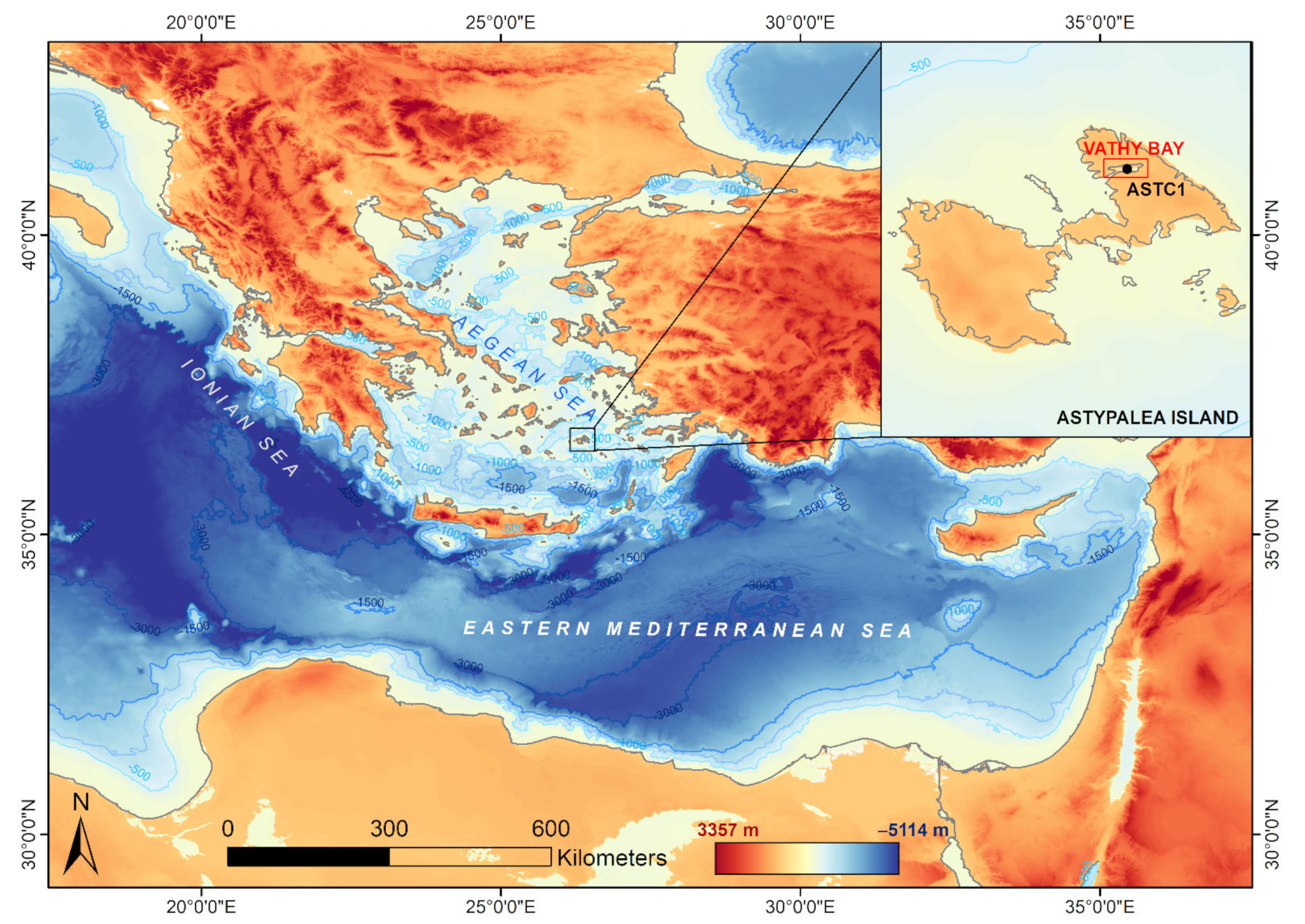
Regional Setting
2. Materials and Methods
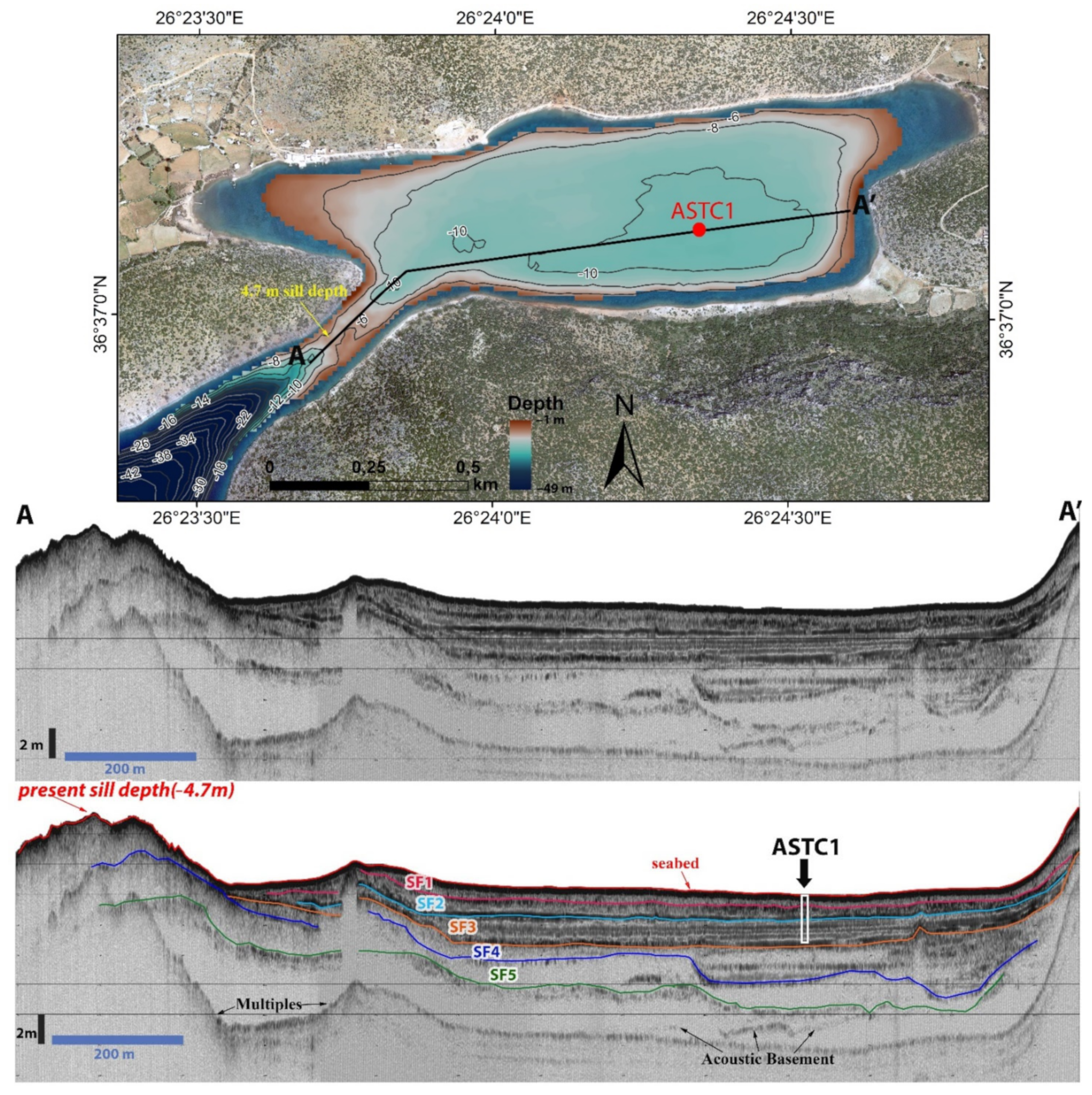
2.1. High-Resolution Seismic Data
2.2. Sedimentological and Geochemical Analyses
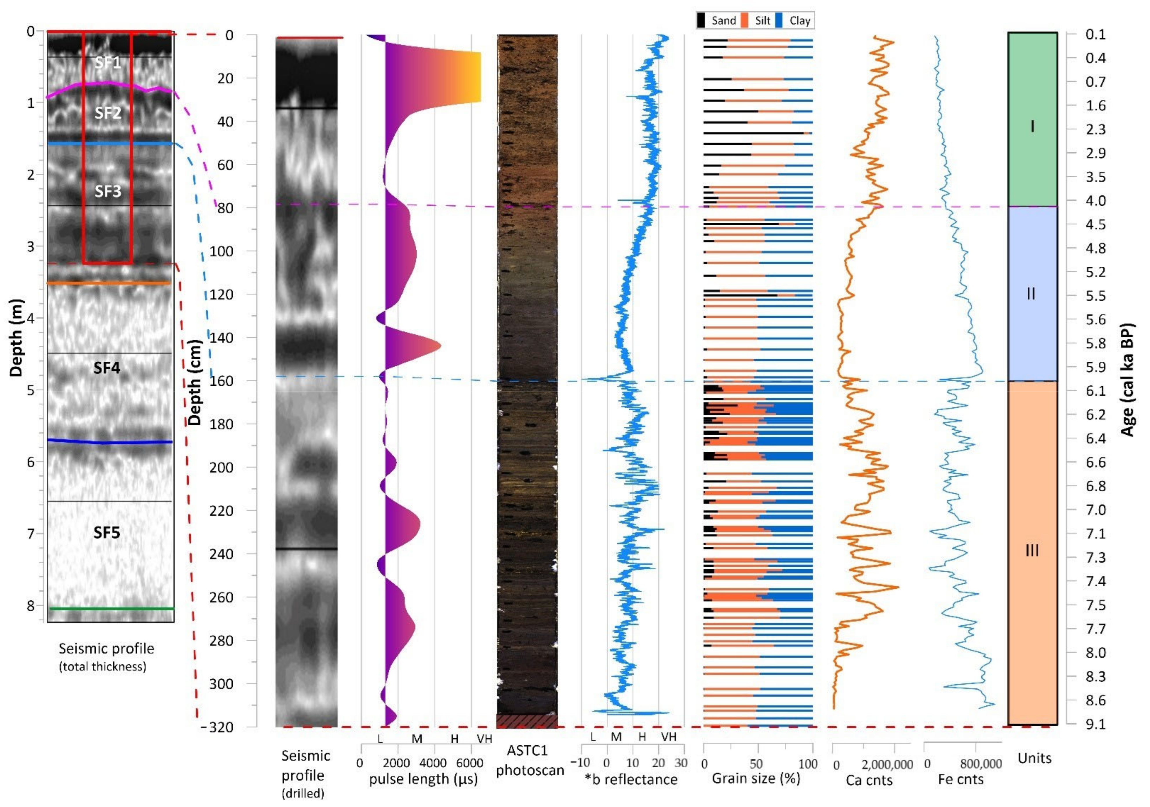
3. Results
3.1. High-Resolution Seismic Data
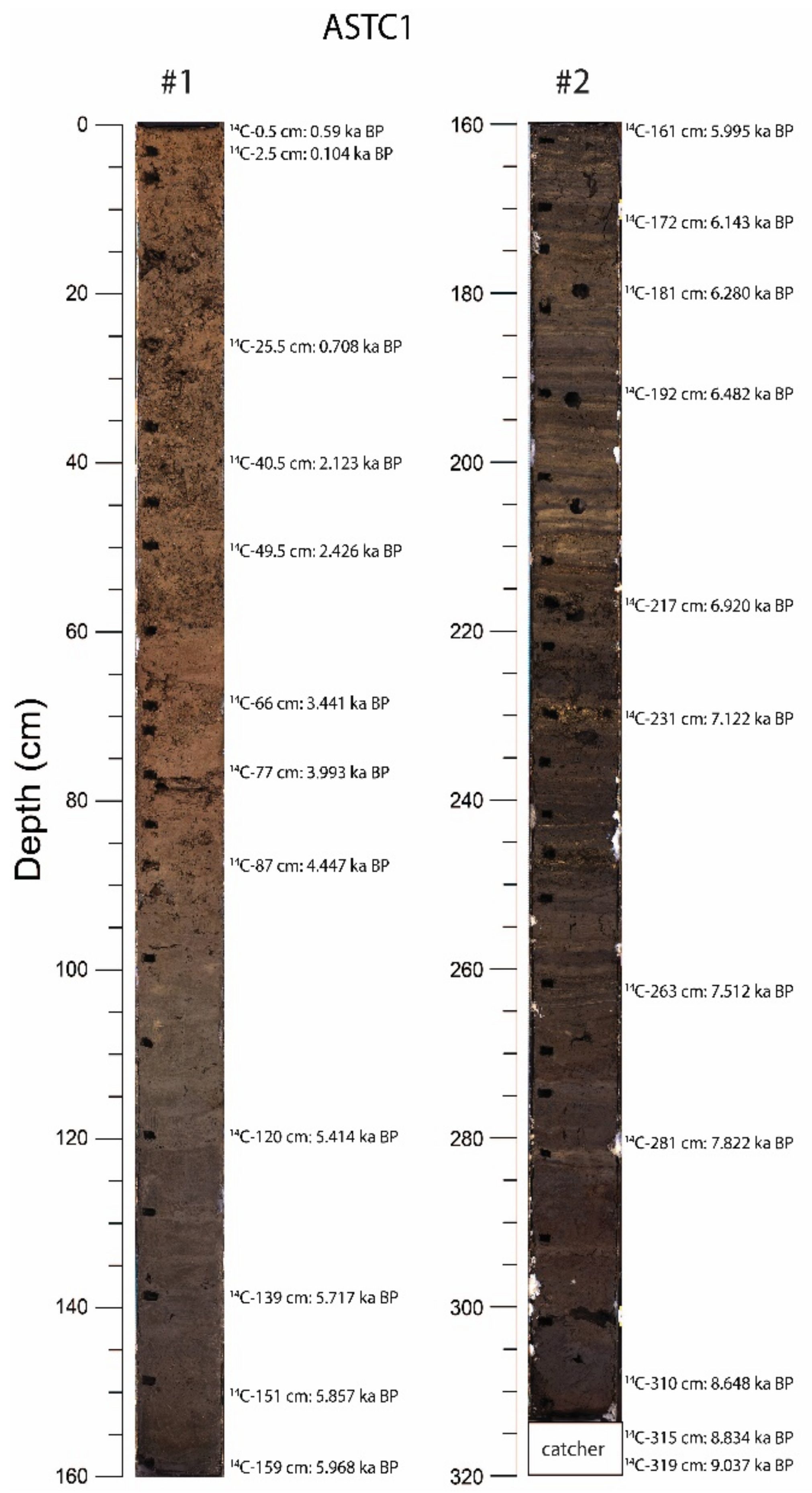
3.2. Core Chronology
3.3. Sedimentary Units
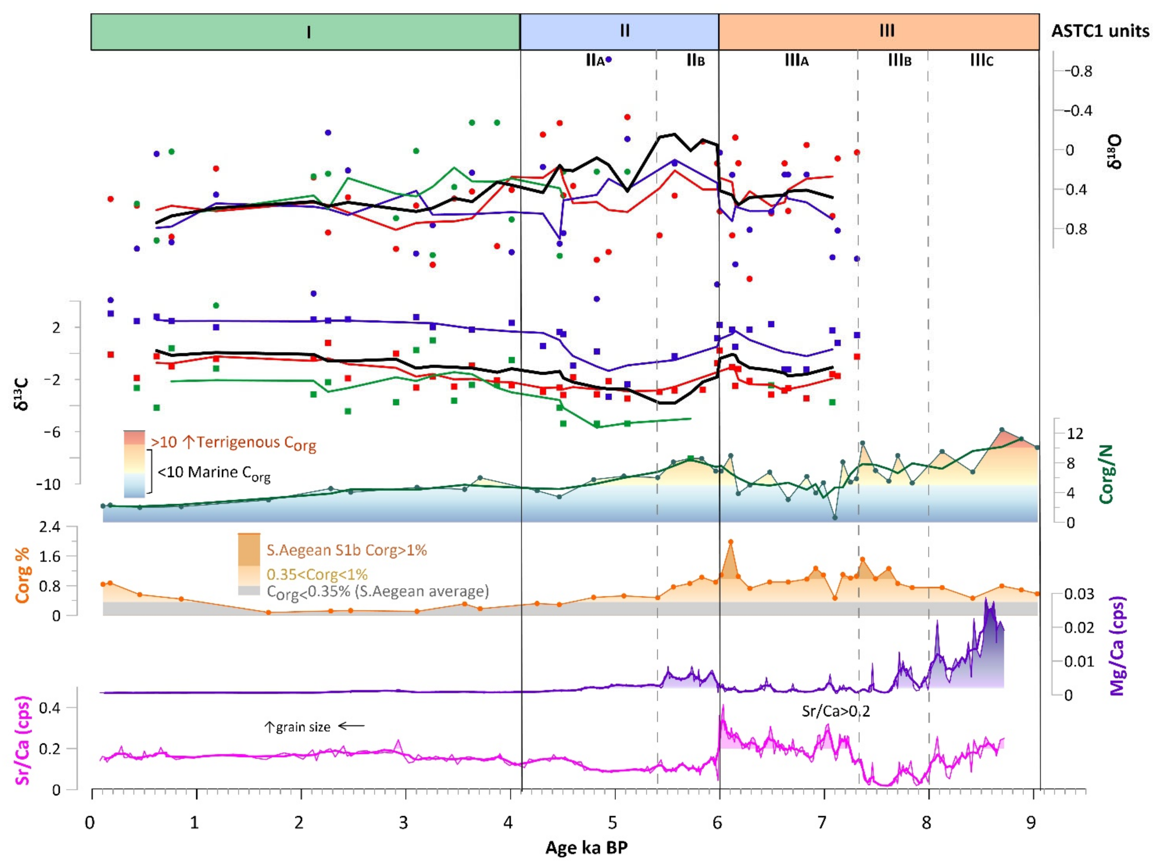
3.4. Carbonate Precipitates
3.5. Organic Carbon Accumulation and Source
3.6. Mollusks and Foraminifera
3.7. Stable Isotopes
4. Discussion
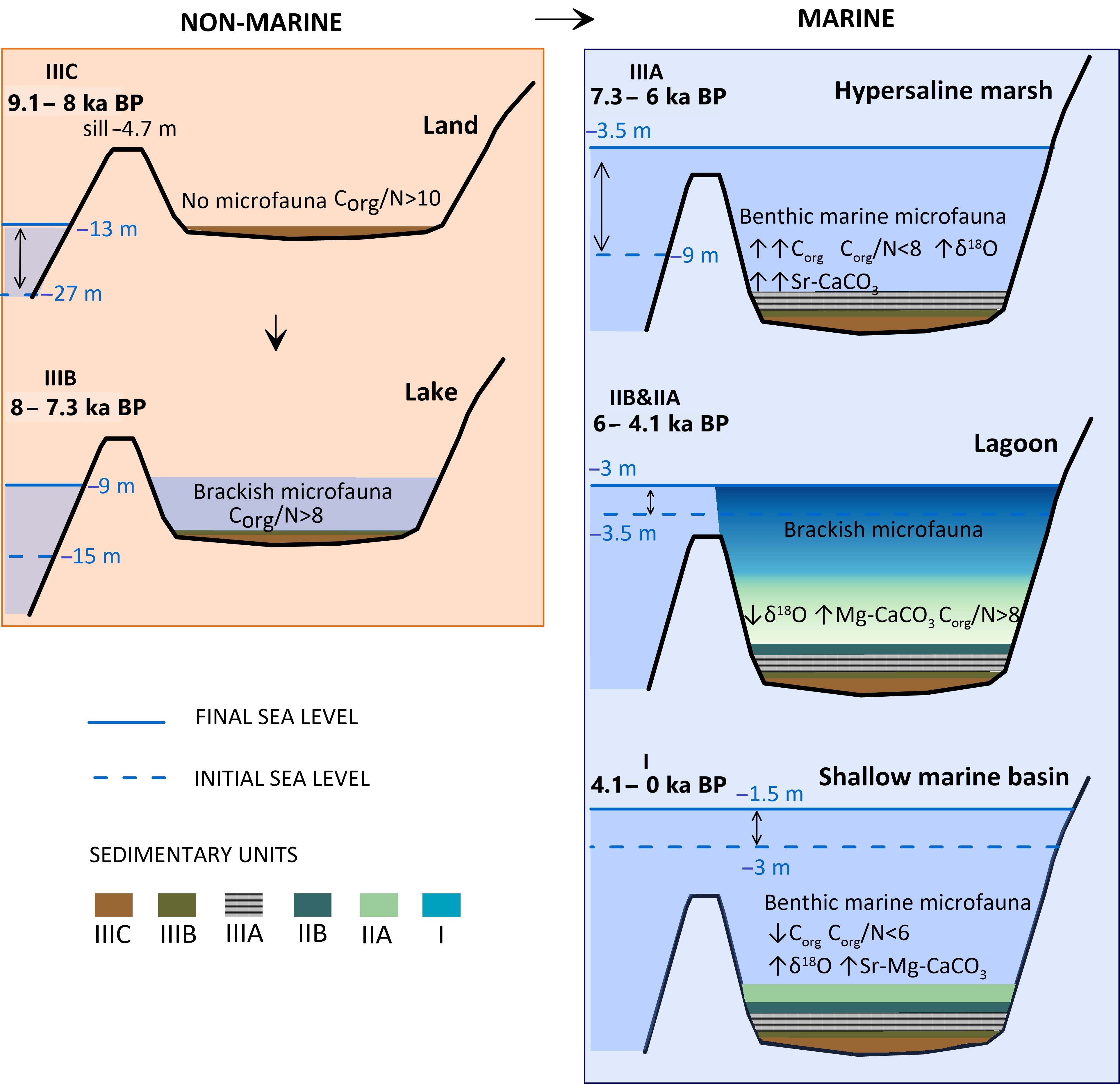
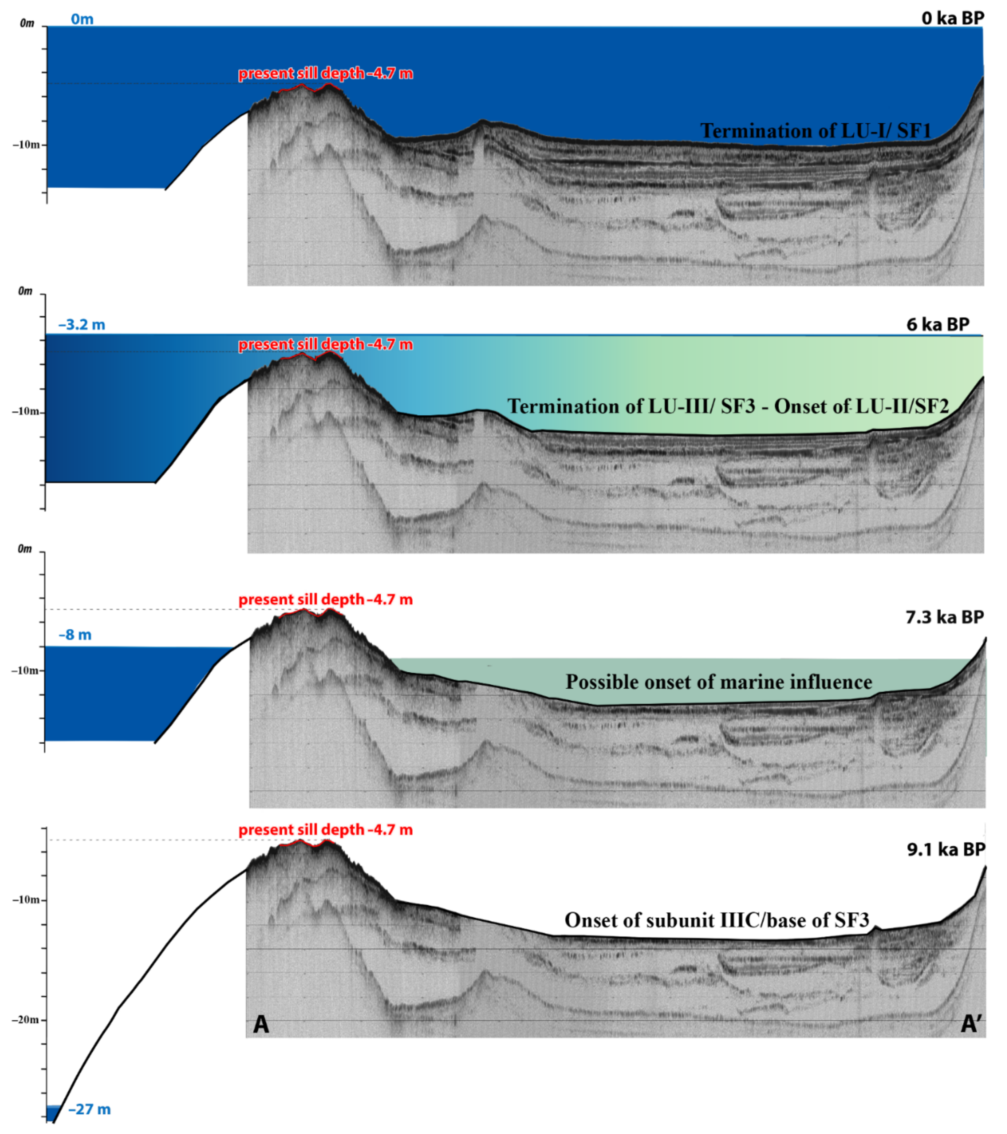
4.1. Palaeoenvironmental Evolution
4.2. Global Sea Level and Flooding of the Bay
4.3. Climate Evolution and Human Inhabitation
5. Conclusions
- The cross-correlation of the seismic and sediment core data presents a causal link and suggests that the basin experienced three major environmental stages during the Holocene recorded as seismic facies (SF1-3) on the profiles and lithological units (LU I-III) in the sedimentary deposits.
- The transition gradually developed through several intermediate environmental stages, as shown by this study, also providing important information on the climatic pattern of the Eastern Mediterranean region. The topography of the Vathy bay forms a natural well-protected area favoring the inhabitation of prehistoric humans. Since Neolithic times, the area has also offered freshwater sources, while the establishment of a series of water bodies contributed to the further exploitation of the associated ecosystems.
- The environmental conditions changed gradually from completely isolated to the present shallow marine in the last 9.1 ka due to the post-glacial sea level rise.
- The onset of the marine influence, according to our findings, is placed at around 7.3 ka when the global mean sea level was at −8 m, ~3 m lower than the basin’s sill. Relative arid outbreaks were pointed out within the 7.3–6 ka BP interval, which favored Sr-rich carbonate precipitation in the basin, and a general aridification or less precipitation trend as of 4.1 ka BP till present.
- Wetter conditions were instead implied for the 9.1–7.3 ka and 6–5.4 ka intervals, which coupled with the general humid conditions in the Eastern Mediterranean at those times.
Supplementary Materials
Author Contributions
Funding
Institutional Review Board Statement
Informed Consent Statement
Data Availability Statement
Acknowledgments
Conflicts of Interest
References
- Rohling, E.J.; Mayewski, P.; Abu-Zied, R.; Casford, J.; Hayes, A. Holocene Atmosphere-Ocean Interactions: Records from Greenland and the Aegean Sea. Clim. Dyn. 2002, 18, 587–594. [Google Scholar] [CrossRef]
- Rohling, E.J.; Marino, G.; Grant, K.M.; Mayewski, P.A.; Weninger, B. A Model for Archaeologically Relevant Holocene Climate Impacts in the Aegean-Levantine Region (Easternmost Mediterranean). Quat. Sci. Rev. 2019, 208, 38–53. [Google Scholar] [CrossRef] [Green Version]
- Rossignol-Strick, M.; Nesteroff, W.; Olive, P.; Vergnaud-Grazzini, C. After the Deluge: Mediterranean Stagnation and Sapropel Formation. Nature 1982, 295, 105–110. [Google Scholar] [CrossRef]
- Emeis, K.C.; Schulz, H.; Struck, U.; Rossignol-Strick, M.; Erlenkeuser, H.; Howell, M.W.; Kroon, D.; Mackensen, A.; Ishizuka, S.; Oba, T.; et al. Eastern Mediterranean Surface Water Temperatures and Δ18O Composition during Deposition of Sapropels in the Late Quaternary. Paleoceanography 2003, 18. [Google Scholar] [CrossRef] [Green Version]
- Rohling, E.J.; Marino, G.; Grant, K.M. Mediterranean Climate and Oceanography, and the Periodic Development of Anoxic Events (Sapropels). Earth-Sci. Rev. 2015, 143, 62–97. [Google Scholar] [CrossRef]
- Hennekam, R.; Jilbert, T.; Schnetger, B.; De Lange, G.J. Solar Forcing of Nile Discharge and Sapropel S1 Formation in the Early to Middle Holocene Eastern Mediterranean. Paleoceanography 2014, 29, 343–356. [Google Scholar] [CrossRef]
- Kidd, R.B.; Cita, M.B.; Ryan, W.B.F. Stratigraphy of Eastern Mediterranean Sapropel Sequences Recovered during DSDP Leg 42A and Their Paleoenvironmental Significance; Government Printing Office: Washington, DC, USA, 1978; Volume 42. [Google Scholar] [CrossRef]
- Shaw, H.F.; Evans, G. The Nature, Distribution and Origin of a Sapropelic Layer in Sediments of the Silicia Basin, Northeastern Mediterranean. Mar. Geol. 1984, 61, 1–12. [Google Scholar] [CrossRef]
- Rohling, E.J.; Gieskes, W.W.C. Late Quaternary Changes in Mediterranean Intermediate Water Density and Formation Rate. Paleoceanography 1989, 4, 531–545. [Google Scholar] [CrossRef]
- Jorissen, F.J.; Asioli, A.; Borsetti, A.M.; Capotondi, L.; de Visser, J.P.; Hilgen, F.J.; Rohling, E.J.; van der Borg, K.; Vergnaud Grazzini, C.; Zachariasse, W.J. Late Quaternary Central Mediterranean Biochronology. Mar. Micropaleontol. 1993, 21, 169–189. [Google Scholar] [CrossRef]
- Rohling, E.J.; de Stigter, H.C.; Vergnaud-Grazzini, C.; Zaalberg, R. Temporary Repopulation by Low-Oxygen Tolerant Benthic Foraminifera within an Upper Pliocene Sapropel: Evidence for the Role of Oxygen Depletion in the Formation of Sapropels. Mar. Micropaleontol. 1993, 22, 207–219. [Google Scholar] [CrossRef]
- Kapsimalis, V.; Drakopoulou, P.; Kapsimalis, V.; Pavlopoulos, K.; Panagiotopoulos, I.; Drakopoulou, P.; Vandarakis, D.; Sakelariou, D.; Anagnostou, C. Geoarchaeological Challenges in the Cyclades Continental Shelf (Aegean Sea). Z. Für Geomorphol. 2009, 53 (Suppl. S1), 169–190. [Google Scholar] [CrossRef]
- Benjamin, J.; Rovere, A.; Fontana, A.; Furlani, S.; Vacchi, M.; Inglis, R.H.; Galili, E.; Antonioli, F.; Sivan, D.; Miko, S.; et al. Late Quaternary Sea-Level Changes and Early Human Societies in the Central and Eastern Mediterranean Basin: An Interdisciplinary Review. Quat. Int. 2017, 449, 29–57. [Google Scholar] [CrossRef] [Green Version]
- Flemming, N.C.; Harff, J.; Moura, D.; Burgess, A.; Bailey, G.N. Submerged Landscapes of the European Continental Shelf: Quaternary Paleoenvironments; Wiley: Hoboken, NJ, USA, 2017; ISBN 9781118922132. [Google Scholar]
- Simaiakis, S.M.; Rijsdijk, K.F.; Koene, E.F.M.; Norder, S.J.; Van Boxel, J.H.; Stocchi, P.; Hammoud, C.; Kougioumoutzis, K.; Georgopoulou, E.; Van Loon, E.; et al. Geographic Changes in the Aegean Sea since the Last Glacial Maximum: Postulating Biogeographic Effects of Sea-Level Rise on Islands. Palaeogeogr. Palaeoclimatol. Palaeoecol. 2017, 471, 108–119. [Google Scholar] [CrossRef]
- Brunović, D.; Miko, S.; Hasan, O.; Papatheodorou, G.; Ilijanić, N.; Miserocchi, S.; Correggiari, A.; Geraga, M. Late Pleistocene and Holocene Paleoenvironmental Reconstruction of a Drowned Karst Isolation Basin (Lošinj Channel, NE Adriatic Sea). Palaeogeogr. Palaeoclimatol. Palaeoecol. 2020, 544, 109587. [Google Scholar] [CrossRef]
- Geraga, M.; Tsaila-Monopolis, S.; Ioakim, C.; Papatheodorou, G.; Ferentinos, G. Evaluation of Palaeoenvironmental Changes during the Last 18,000 Years in the Myrtoon Basin, SW Aegean Sea. Palaeogeogr. Palaeoclimatol. Palaeoecol. 2000, 156, 1–17. [Google Scholar] [CrossRef]
- Geraga, M.; Tsaila-Monopolis, S.; Ioakim, C.; Papatheodorou, G.; Ferentinos, G. Short-Term Climate Changes in the Southern Aegean Sea over the Last 48,000 Years. Palaeogeogr. Palaeoclimatol. Palaeoecol. 2005, 220, 311–332. [Google Scholar] [CrossRef]
- Geraga, M.; Ioakim, C.; Lykousis, V.; Tsaila-monopolis, S.; Mylona, G. The High-Resolution Palaeoclimatic and Palaeoceanographic History of the Last 24,000 Years in the Central Aegean Sea, Greece. Palaeogeogr. Palaeoclimatol. Palaeoecol. 2010, 287, 101–115. [Google Scholar] [CrossRef]
- Kouli, K.; Gogou, A.; Bouloubassi, I.; Triantaphyllou, M.V.; Ioakim, C.; Katsouras, G.; Roussakis, G.; Lykousis, V. Late Postglacial Paleoenvironmental Change in the Northeastern Mediterranean Region: Combined Palynological and Molecular Biomarker Evidence. Quat. Int. 2012, 261, 118–127. [Google Scholar] [CrossRef]
- Triantaphyllou, M.V.; Gogou, A.; Dimiza, M.D.; Kostopoulou, S.; Parinos, C.; Roussakis, G.; Geraga, M.; Bouloubassi, I.; Fleitmann, D.; Zervakis, V.; et al. Holocene Climatic Optimum Centennial-Scale Paleoceanography in the NE Aegean (Mediterranean Sea). Geo-Mar. Lett. 2016, 36, 51–66. [Google Scholar] [CrossRef]
- Sondi, I.; Mikac, N.; Vdović, N.; Ivanić, M.; Furdek, M.; Škapin, S.D. Geochemistry of Recent Aragonite-Rich Sediments in Mediterranean Karstic Marine Lakes: Trace Elements as Pollution and Palaeoredox Proxies and Indicators of Authigenic Mineral Formation. Chemosphere 2017, 168, 786–797. [Google Scholar] [CrossRef]
- Lambeck, K.; Rouby, H.; Purcell, A.; Sun, Y.; Sambridge, M. Sea Level and Global Ice Volumes from the Last Glacial Maximum to the Holocene. Proc. Natl. Acad. Sci. USA 2014, 111, 15296–15303. [Google Scholar] [CrossRef] [PubMed] [Green Version]
- Lambeck, K.; Purcell, A. Sea-Level Change in the Mediterranean Sea since the LGM: Model Predictions for Tectonically Stable Areas. Quat. Sci. Rev. 2005, 24, 1969–1988. [Google Scholar] [CrossRef]
- Sivan, D.; Wdowinski, S.; Lambeck, K.; Galili, E.; Raban, A. Holocene Sea-Level Changes along the Mediterranean Coast of Israel, Based on Archaeological Observations and Numerical Model. Palaeogeogr. Palaeoclimatol. Palaeoecol. 2001, 167, 101–117. [Google Scholar] [CrossRef]
- Perdue, E.M.; Koprivnjak, J.-F. Using the C/N Ratio to Estimate Terrigenous Inputs of Organic Matter to Aquatic Environments. Estuar. Coast. Shelf Sci. 2007, 73, 65–72. [Google Scholar] [CrossRef]
- Desruelles, S.; Fouache, É.; Ciner, A.; Dalongeville, R.; Pavlopoulos, K.; Kosun, E.; Coquinot, Y.; Potdevin, J.L. Beachrocks and Sea Level Changes since Middle Holocene: Comparison between the Insular Group of Mykonos-Delos-Rhenia (Cyclades, Greece) and the Southern Coast of Turkey. Glob. Planet. Chang. 2009, 66, 19–33. [Google Scholar] [CrossRef]
- Pavlopoulos, K.; Theodorakopoulou, K. Relative Sea-Level Changes in Aegean Coastal Areas during Holocene: A Geoarchaeological View. J. Earth Sci. 2010, 21, 244–246. [Google Scholar]
- Evelpidou, N.; Pavlopoulos, K.; Vassilopoulos, A.; Triantaphyllou, M.; Vouvalidis, K.; Syrides, G. Yria (Western Naxos Island, Greece): Sea Level Changes in Upper Holocene and Palaeogeographical Reconstruction. Geodin. Acta 2010, 23, 233–240. [Google Scholar] [CrossRef] [Green Version]
- Emmanouilidis, A.; Unkel, I.; Seguin, J.; Keklikoglou, K.; Gianni, E.; Avramidis, P. Application of Non-Destructive Techniques on a Varve Sediment Record from Vouliagmeni Coastal Lake, Eastern Gulf of Corinth, Greece. Appl. Sci. 2020, 10, 8273. [Google Scholar] [CrossRef]
- Vött, A. Relative Sea Level Changes and Regional Tectonic Evolution of Seven Coastal Areas in NW Greece since the Mid-Holocene. Quat. Sci. Rev. 2007, 26, 894–919. [Google Scholar] [CrossRef]
- Sergiou, S.; Geraga, M.; Rohling, E.J.; Rodríguez-Sanz, L.; Hadjisolomou, E.; Paraschos, F.; Sakellariou, D.; Bailey, G. Influences of Sea Level Changes and the South Asian Monsoon on Southern Red Sea Oceanography over the Last 30 Ka. Quat. Res. 2022, 1–19. [Google Scholar] [CrossRef]
- Triantaphyllou, M.V.; Gogou, A.; Bouloubassi, I.; Dimiza, M.; Kouli, K.; Rousakis, G.; Kotthoff, U.; Emeis, K.C.; Papanikolaou, M.; Athanasiou, M.; et al. Evidence for a Warm and Humid Mid-Holocene Episode in the Aegean and Northern Levantine Seas (Greece, NE Mediterranean). Reg. Environ. Chang. 2014, 14, 1697–1712. [Google Scholar] [CrossRef]
- Haghani, S.; Leroy, S.A.G.; Wesselingh, F.P.; Rose, N.L. Rapid Evolution of Coastal Lagoons in Response to Human Interference under Rapid Sea Level Change: A South Caspian Sea Case Study. Quat. Int. 2016, 408, 93–112. [Google Scholar] [CrossRef] [Green Version]
- Koutsodendris, A.; Brauer, A.; Zacharias, I.; Putyrskaya, V.; Klemt, E.; Sangiorgi, F.; Pross, J. Ecosystem Response to Human- and Climate-Induced Environmental Stress on an Anoxic Coastal Lagoon (Etoliko, Greece) since 1930 AD. J. Paleolimnol. 2015, 53, 255–270. [Google Scholar] [CrossRef]
- Papazachos, B.C. Seismicity of the Aegean and Surrounding Area. Tectonophysics 1990, 178, 287–308. [Google Scholar] [CrossRef]
- Zweng, M.M.; Reagan, J.R.; Seidov, D.; Boyer, T.P.; Locarnini, R.A.; Garcia, H.E.; Mishonov, A.V.; Baranova, O.K.; Weathers, K.W.; Paver, C.R.; et al. World Ocean Atlas 2018, Volume 2: Salinity; NOAA Atlas NESDIS 82; A. Mishonov, Technical Editor: Silver Spring, MD, USA, 2019; p. 50. [Google Scholar]
- Vlachopoulos, A. Excavation at vathy of astypalea island. In Proceedings of the Athenian Archaeological Society, Athens, Greece, 16 January 2016; pp. 328–356. [Google Scholar]
- Berger, J.-F.; Lespez, L.; Kuzucuoğlu, C.; Glais, A.; Hourani, F.; Barra, A.; Guilaine, J. Interactions between Climate Change and Human Activities during the Early to Mid-Holocene in the Eastern Mediterranean Basins. Clim. Past 2016, 12, 1847–1877. [Google Scholar] [CrossRef] [Green Version]
- Bailey, G.N.; Flemming, N.C. Archaeology of the Continental Shelf: Marine Resources, Submerged Landscapes and Underwater Archaeology. Quat. Sci. Rev. 2008, 27, 2153–2165. [Google Scholar] [CrossRef] [Green Version]
- Theocharis, A.; Balopoulos, E.; Kioroglou, S.; Kontoyiannis, H.; Iona, A. A Synthesis of the Circulation and Hydrography of the South Aegean Sea and the Straits of the Cretan Arc (March 1994–January 1995). Prog. Oceanogr. 1999, 44, 469–509. [Google Scholar] [CrossRef]
- Zervakis, V.; Georgopoulos, D.; Drakopoulos, P.G. The Role of the North Aegean in Triggering the Recent Eastern Mediterranean Climatic Changes. J. Geophys. Res. Ocean. 2000, 105, 26103–26116. [Google Scholar] [CrossRef]
- Lykousis, V.; Chronis, G.; Tselepides, A.; Price, N.B.; Theocharis, A.; Siokou-Frangou, I.; Van Wambeke, F.; Danovaro, R.; Stavrakakis, S.; Duineveld, G.; et al. Major Outputs of the Recent Multidisciplinary Biogeochemical Researches Undertaken in the Aegean Sea. J. Mar. Syst. 2002, 33–34, 313–334. [Google Scholar] [CrossRef]
- Poulos, E.; Ghionis, G.; Maroukian, H. Geomorphology Sea-Level Rise Trends in the Attico—Cycladic Region (Aegean Sea) during the Last 5000 Years. Geomorphology 2009, 107, 10–17. [Google Scholar] [CrossRef]
- Stavrakakis, S.; Chronis, G.; Tselepides, A.; Heussner, S.; Monaco, A.; Abassi, A. Downward Fluxes of Settling Particles in the Deep Cretan Sea (NE Mediterranean). Prog. Oceanogr. 2000, 46, 217–240. [Google Scholar] [CrossRef]
- Lykousis, V. Submarine Slope Instabilities in the Hellenic Arc Region, Northeastern Mediterranean Sea. Mar. Geotechnol. 1991, 10, 83–96. [Google Scholar] [CrossRef]
- Piper, D.J.W.; Perissoratis, C. Late Quaternary Sedimentation on the North Aegean Continental Margin, Greece 1. Am. Assoc. Pet. Geol. Bull. 1991, 75, 46–61. [Google Scholar] [CrossRef]
- Perissoratis, C.; Conispoliatis, N. The Impacts of Sea-Level Changes during Latest Pleistocene and Holocene Times on the Morphology of the Ionian and Aegean Seas (SE Alpine Europe). Mar. Geol. 2003, 196, 145–156. [Google Scholar] [CrossRef]
- Pavlides, S.; Caputo, R. Magnitude versus Faults’ Surface Parameters: Quantitative Relationships from the Aegean Region. Tectonophysics 2004, 380, 159–188. [Google Scholar] [CrossRef]
- Lykousis, V.; Karageorgis, A.P.; Chronis, G.T. Delta Progradation and Sediment Fluxes since the Last Glacial in the Thermaikos Gulf and the Sporades Basin, NW Aegean Sea, Greece. Mar. Geol. 2005, 222–223, 381–397. [Google Scholar] [CrossRef]
- Lykousis, V.Ã. Sea-Level Changes and Shelf Break Prograding Sequences during the Last 400 Ka in the Aegean Margins: Subsidence Rates and Palaeogeographic Implications. Cont. Shelf Res. 2009, 29, 2037–2044. [Google Scholar] [CrossRef]
- Tsampouraki-Kraounaki, K.; Sakellariou, D.; Rousakis, G.; Morfis, I.; Panagiotopoulos, I.; Livanos, I.; Manta, K.; Paraschos, F.; Papatheodorou, G. The Santorini-Amorgos Shear Zone: Evidence for Dextral Transtension in the South Aegean Back-Arc Region, Greece. Geosciences 2021, 11, 216. [Google Scholar] [CrossRef]
- Nomikou, P.; Hübscher, C.; Papanikolaou, D.; Farangitakis, G.P.; Ruhnau, M.; Lampridou, D. Expanding Extension, Subsidence and Lateral Segmentation within the Santorini-Amorgos Basins during Quaternary: Implications for the 1956 Amorgos Events, Central-South Aegean Sea, Greece. Tectonophysics 2018, 722, 138–153. [Google Scholar] [CrossRef]
- Blott, S.J.; Pye, K. GRADISTAT: A grain size distribution and statistics package for the analysis of unconsolidated sediments. Tech. Commun. 2001, 1248, 1237–1248. [Google Scholar] [CrossRef]
- van Santvoort, P.J.M.; de Lange, G.J.; Thomson, J.; Cussen, H.; Wilson, T.R.S.; Krom, M.D.; Ströhle, K. Active Post-Depositional Oxidation of the Most Recent Sapropel (S1) in Sediments of the Eastern Mediterranean Sea. Geochim. Cosmochim. Acta 1996, 60, 4007–4024. [Google Scholar] [CrossRef]
- Nagao, S.; Nakashima, S. The Factors Controlling Vertical Color Variations of North Atlantic Madeira Abyssal Plain Sediments. Mar. Geol. 1992, 109, 83–94. [Google Scholar] [CrossRef]
- Wu, L.; Wang, R.; Krijgsman, W.; Chen, Z.; Xiao, W.; Ge, S.; Wu, J. Deciphering Color Reflectance Data of a 520-Kyr Sediment Core From the Southern Ocean: Method Application and Paleoenvironmental Implications. Geochem. Geophys. Geosyst. 2019, 20, 2808–2826. [Google Scholar] [CrossRef] [Green Version]
- Giosan, L.; Flood, R.D.; Aller, R.C. Paleoceanographic Significance of Sediment Color on Western North Atlantic Drifts: I. Origin of Color. Mar. Geol. 2002, 189, 25–41. [Google Scholar] [CrossRef]
- Weltje, G.J.; Bloemsma, M.R.; Tjallingii, R.; Heslop, D.; Röhl, U.; Croudace, I.W.; Croudace, I.W. Prediction of Geochemical Composition from XRF Core Scanner Data: A New Multivariate Approach Including Automatic Selection of Calibration Samples and Quantification of Uncertainties; Developments in Paleoenvironmental Research Book Series; Springer: Berlin/Heidelberg, Germany, 2015; Volume 17, pp. 507–534. [Google Scholar] [CrossRef]
- Heslop, D.; Dillon, M. Unmixing Magnetic Remanence Curves without a Priori Knowledge. Geophys. J. Int. 2007, 170, 556–566. [Google Scholar] [CrossRef] [Green Version]
- Ji, S.; Xingqi, L.; Sumin, W.; Matsumoto, R. Palaeoclimatic Changes in the Qinghai Lake Area during the Last 18,000 Years. Quat. Int. 2005, 136, 131–140. [Google Scholar] [CrossRef]
- Rein, B.; Sirocko, F. In-Situ Reflectance Spectroscopy—Analysing Techniques for High-Resolution Pigment Logging in Sediment Cores. Int. J. Earth Sci. 2002, 91, 950–954. [Google Scholar] [CrossRef]
- Heaton, T.J.; Köhler, P.; Butzin, M.; Bard, E.; Reimer, R.W.; Austin, W.E.N.; Bronk Ramsey, C.; Grootes, P.M.; Hughen, K.A.; Kromer, B.; et al. Marine20—The Marine Radiocarbon Age Calibration Curve (0–55,000 Cal BP). Radiocarbon 2020, 62, 779–820. [Google Scholar] [CrossRef]
- Marino, G.; Rohling, E.J.; Sangiorgi, F.; Hayes, A.; Casford, J.L.; Lotter, A.F.; Kucera, M.; Brinkhuis, H. Early and Middle Holocene in the Aegean Sea: Interplay between High and Low Latitude Climate Variability. Quat. Sci. Rev. 2009, 28, 3246–3262. [Google Scholar] [CrossRef]
- Blaauw, M.; Christen, J.A. Flexible Paleoclimate Age-Depth Models Using an Autoregressive Gamma Process. Bayesian Anal. 2011, 6, 457–474. [Google Scholar] [CrossRef]
- Mook, W.G.; van der Plicht, J. Reporting 14C Activities and Concentrations. Radiocarbon 1999, 41, 227–239. [Google Scholar] [CrossRef] [Green Version]
- Kinsman, D.J.J. Interpretation of Sr (Super +2) Concentrations in Carbonate Minerals and Rocks. J. Sediment. Res. 1969, 39, 486–508. [Google Scholar] [CrossRef]
- Rothwell, R.G.; Hoogakker, B.; Thomson, J.; Croudace, I.W.; Frenz, M. Turbidite Emplacement on the Southern Balearic Abyssal Plain (Western Mediterranean Sea) during Marine Isotope Stages 1–3: An Application of ITRAX XRF Scanning of Sediment Cores to Lithostratigraphic Analysis. Geol. Soc. London Spec. Publ. 2006, 267, 79–98. [Google Scholar] [CrossRef]
- Wilkinson, B.H.; Given, R.K. Secular Variation in Abiotic Marine Carbonates: Constraints on Phanerozoic Atmospheric Carbon Dioxide Contents and Oceanic Mg/Ca Ratios. J. Geol. 1986, 94, 321–333. [Google Scholar] [CrossRef]
- Kelts, K.; Hsü, K.J. Freshwater Carbonate Sedimentation. In Lakes; Springer: New York, NY, USA, 1978; pp. 295–323. [Google Scholar] [CrossRef]
- Bayon, G.; Pierre, C.; Etoubleau, J.; Voisset, M.; Cauquil, E.; Marsset, T.; Sultan, N.; Le Drezen, E.; Fouquet, Y. Sr/Ca and Mg/Ca Ratios in Niger Delta Sediments: Implications for Authigenic Carbonate Genesis in Cold Seep Environments. Mar. Geol. 2007, 241, 93–109. [Google Scholar] [CrossRef] [Green Version]
- De Choudens-Sánchez, V.; Gonzalez, L.A. Calcite and Aragonite Precipitation Under Controlled Instantaneous Supersaturation: Elucidating the Role of CaCO3 Saturation State and Mg/Ca Ratio on Calcium Carbonate Polymorphism. J. Sediment. Res. 2009, 79, 363–376. [Google Scholar] [CrossRef]
- Sondi, I.; Juračić, M. Whiting Events and the Formation of Aragonite in Mediterranean Karstic Marine Lakes: New Evidence on Its Biologically Induced Inorganic Origin. Sedimentology 2010, 57, 85–95. [Google Scholar] [CrossRef]
- Meyers, P.A. Lacustrine Organic Geochemistry—An Overview of Indicators of Organic Matter Sources and Diagenesis in Lake Sediments. Org. Geochem. 1993, 20, 867–900. [Google Scholar] [CrossRef]
- Meyers, P.A. Preservation of Elemental and Isotopic Source Identification of Sedimentary Organic Matter. Chem. Geol. 1994, 114, 289–302. [Google Scholar] [CrossRef] [Green Version]
- Fuksi, T.; Tomašových, A.; Gallmetzer, I.; Haselmair, A.; Zuschin, M. 20th Century Increase in Body Size of a Hypoxia-Tolerant Bivalve Documented by Sediment Cores from the Northern Adriatic Sea (Gulf of Trieste). Mar. Pollut. Bull. 2018, 135, 361–375. [Google Scholar] [CrossRef]
- Leontarakis, P.K.; Xatzianastasiou, L.I.; Theodorou, J.A. Biological Aspects of the Lagoon Cockle, Cerastoderma Glaucum (Poiret 1879), in a Coastal Lagoon in Keramoti, Greece in the Northeastern Mediterranean. J. Shellfish Res. 2008, 27, 1171–1175. [Google Scholar] [CrossRef]
- Debenay, J.-P.; Payri, C.E. Epiphytic foraminiferal assemblages on macroalgae in reefal environments of new caledonia. J. Foraminifer. Res. 2010, 40, 36–60. [Google Scholar] [CrossRef]
- Barmawidjaja, D.M.; Van der Zwaan, G.J.; Jorissen, F.J.; Puskaric, S. 150 Years of Eutrophication in the Northern Adriatic Sea: Evidence from a Benthic Foraminiferal Record. Mar. Geol. 1995, 122, 367–384. [Google Scholar] [CrossRef]
- Faber, W.W. Distribution and Substrate Preference of Peneroplis Planatus and P. Arientinus from the Halophia Meadow near Wadi Taba, Eilat, Israel. J. Foraminifer. Res. 1991, 21, 218–221. [Google Scholar] [CrossRef]
- Frontalini, F.; Coccioni, R. Benthic Foraminifera as Bioindicators of Pollution: A Review of Italian Research over the Last Three Decades. Rev. Micropaléontol. 2011, 54, 115–127. [Google Scholar] [CrossRef]
- Jorissen, F.; Nardelli, M.P.; Almogi-Labin, A.; Barras, C.; Bergamin, L.; Bicchi, E.; El Kateb, A.; Ferraro, L.; McGann, M.; Morigi, C.; et al. Developing Foram-AMBI for Biomonitoring in the Mediterranean: Species Assignments to Ecological Categories. Mar. Micropaleontol. 2018, 140, 33–45. [Google Scholar] [CrossRef] [Green Version]
- Dimiza, M.D.; Triantaphyllou, M.V.; Koukousioura, O.; Hallock, P.; Simboura, N.; Karageorgis, A.P.; Papathanasiou, E. The Foram Stress Index: A New Tool for Environmental Assessment of Soft-Bottom Environments Using Benthic Foraminifera. A Case Study from the Saronikos Gulf, Greece, Eastern Mediterranean. Ecol. Indic. 2016, 60, 611–621. [Google Scholar] [CrossRef]
- Khanaqa, P.A.; Karim, K.H.; Thiel, V. Characeae-Derived Carbonate Deposits in Lake Ganau, Kurdistan Region, Iraq. Facies 2013, 59, 653–662. [Google Scholar] [CrossRef]
- Murray, J.W. Ecology and Applications of Benthic Foraminifera; Cambridge University Press: Cambridge, UK, 2006; ISBN 0521828392. [Google Scholar]
- Scourse, J.D.; Kennedy, H.; Scott, G.A.; Austin, W.E.N. Stable Isotopic Analyses of Modern Benthic Foraminifera from Seasonally Stratified Shelf Seas: Disequilibria and the “Seasonal Effect”. Holocene 2004, 14, 747–758. [Google Scholar] [CrossRef] [Green Version]
- Austin, W.E.N.; Scourse, J.D. Evolution of Seasonal Stratification in the Celtic Sea during the Holocene. J. Geol. Soc. London 1997, 154, 249–256. [Google Scholar] [CrossRef]
- Scourse, J.D.; Austin, W.E.N.; Long, B.T.; Assinder, D.J.; Huws, D. Holocene Evolution of Seasonal Stratification in the Celtic Sea: Refined Age Model, Mixing Depths and Foraminiferal Stratigraphy. Mar. Geol. 2002, 191, 119–145. [Google Scholar] [CrossRef]
- Woods, M.A.; Wilkinson, I.P.; Leng, M.J.; Riding, J.B.; Vane, C.H.; Lopes dos Santos, R.A.; Kender, S.; De Schepper, S.; Hennissen, J.A.I.; Ward, S.L.; et al. Tracking Holocene Palaeostratification and Productivity Changes in the Western Irish Sea: A Multi-Proxy Record. Palaeogeogr. Palaeoclimatol. Palaeoecol. 2019, 532, 109231. [Google Scholar] [CrossRef]
- Grossman, E.L. Carbon Isotopic Fractionation in Live Benthic Foraminifera—Comparison with Inorganic Precipitate Studies. Geochim. Cosmochim. Acta 1984, 48, 1505–1512. [Google Scholar] [CrossRef]
- McCorkle, D.C.; Keigwin, L.D.; Corliss, B.H.; Emerson, S.R. The Influence of Microhabitats on the Carbon Isotopic Composition of Deep-Sea Benthic Foraminifera. Paleoceanography 1990, 5, 161–185. [Google Scholar] [CrossRef]
- McCorkle, D.C.; Corliss, B.H.; Farnham, C.A. Vertical Distributions and Stable Isotopic Compositions of Live (Stained) Benthic Foraminifera from the North Carolina and California Continental Margins. Deep Sea Res. Part I Oceanogr. Res. Pap. 1997, 44, 983–1024. [Google Scholar] [CrossRef]
- Rathburn, A.E.; Corliss, B.H.; Tappa, K.D.; Lohmann, K.C. Comparisons of the Ecology and Stable Isotopic Compositions of Living (Stained) Benthic Foraminifera from the Sulu and South China Seas. Deep Sea Res. Part I Oceanogr. Res. Pap. 1996, 43, 1617–1646. [Google Scholar] [CrossRef]
- Mackensen, A.; Wollenburg, J.; Licari, L. Methane Venting Documented by Lowest Hitherto Reported δ 13 C of Live Epibenthic Foraminifer Fontbotia Wuellerstorfi. In Proceedings of the AGU Fall Meeting Abstracts, San Francisco, CA, USA, 13–17 December 2004; Volume 2004, pp. PP23B–1437. [Google Scholar]
- Fontanier, C.; Mackensen, A.; Jorissen, F.J.; Anschutz, P.; Licari, L.; Griveaud, C. Stable Oxygen and Carbon Isotopes of Live Benthic Foraminifera from the Bay of Biscay: Microhabitat Impact and Seasonal Variability. Mar. Micropaleontol. 2006, 58, 159–183. [Google Scholar] [CrossRef]
- Schmiedl, G.; Pfeilsticker, M.; Hemleben, C.; Mackensen, A. Environmental and Biological Effects on the Stable Isotope Composition of Recent Deep-Sea Benthic Foraminifera from the Western Mediterranean Sea. Mar. Micropaleontol. 2004, 51, 129–152. [Google Scholar] [CrossRef]
- Martin, G.; Torn, K.; Blindow, I.; Schubert, H.; Munsterhjelm, R.; Henricson, C. Introduction to Charophytes. In Charophytes of the Baltic Sea; Schubert, H., Blindow, I., Eds.; Gantner Verlag: Starnberg, Gernmany, 2003; Volume 19, pp. 3–14. [Google Scholar]
- Roeser, P.; Franz, S.O.; Litt, T. Aragonite and Calcite Preservation in Sediments from Lake Iznik Related to Bottom Lake Oxygenation and Water Column Depth. Sedimentology 2016, 63, 2253–2277. [Google Scholar] [CrossRef]
- Schemmel, F.; Niedermeyer, E.M.; Koutsodendris, A.; Pross, J.; Fiebig, J.; Mulch, A. Paleohydrological Changes in the Eastern Mediterranean Region during the Early to Mid-Holocene Recorded in Plant Wax n-Alkane Distributions and Δ13C TOC—New Data from Tenaghi Philippon, NE Greece. Org. Geochem. 2017, 110, 100–109. [Google Scholar] [CrossRef]
- Cheng, H.; Sinha, A.; Verheyden, S.; Nader, F.H.; Li, X.L.; Zhang, P.Z.; Yin, J.J.; Yi, L.; Peng, Y.B.; Rao, Z.G.; et al. The Climate Variability in Northern Levant over the Past 20,000 Years. Geophys. Res. Lett. 2015, 42, 8641–8650. [Google Scholar] [CrossRef] [Green Version]
- Ariztegui, D.; Anselmetti, F.S.; Robbiani, J.M.; Bernasconi, S.M.; Brati, E.; Gilli, A.; Lehmann, M.F. Natural and Human-Induced Environmental Change in Southern Albania for the Last 300 Years—Constraints from the Lake Butrint Sedimentary Record. Glob. Planet. Chang. 2010, 71, 183–192. [Google Scholar] [CrossRef] [Green Version]
- Clarke, J.; Brooks, N.; Banning, E.B.; Bar-Matthews, M.; Campbell, S.; Clare, L.; Cremaschi, M.; di Lernia, S.; Drake, N.; Gallinaro, M.; et al. Climatic Changes and Social Transformations in the Near East and North Africa during the ‘Long’ 4th Millennium BC: A Comparative Study of Environmental and Archaeological Evidence. Quat. Sci. Rev. 2016, 136, 96–121. [Google Scholar] [CrossRef]
- Ben Dor, Y.; Neugebauer, I.; Enzel, Y.; Schwab, M.J.; Tjallingii, R.; Erel, Y.; Brauer, A. Varves of the Dead Sea Sedimentary Record. Quat. Sci. Rev. 2019, 215, 173–184. [Google Scholar] [CrossRef]
- Vail, P.R.; Mitchum, R.M., Jr.; Thompson, S., III. Seismic Stratigraphy and Global Changes of Sea Level, Part 3: Relative Changes of Sea Level from Coastal Onlap. In Seismic Stratigraphy—Applications to Hydrocarbon Exploration; Payton, C.E., Ed.; American Association of Petroleum Geologists: Tulsa, OK, USA, 1997; Volume 26. [Google Scholar] [CrossRef]
- Piper, D.J.W.; Perissoratis, C. Quaternary Neotectonics of the South Aegean arc. Mar. Geol. 2003, 198, 259–288. [Google Scholar] [CrossRef]
- Spratt, R.M.; Lisiecki, L.E. A Late Pleistocene Sea Level Stack. Clim. Past 2016, 12, 1079–1092. [Google Scholar] [CrossRef] [Green Version]
- Karkani, A.; Evelpidou, N.; Tzouxanioti, M.; Petropoulos, A.; Gogou, M.; Mloukie, E. Tsunamis in the Greek Region: An Overview of Geological and Geomorphological Evidence. Geosciences 2022, 12, 4. [Google Scholar] [CrossRef]
- De Lange, G.J.; Thomson, J.; Reitz, A.; Slomp, C.P.; Speranza Principato, M.; Erba, E.; Corselli, C. Synchronous Basin-Wide Formation and Redox-Controlled Preservation of a Mediterranean Sapropel. Nat. Geosci. 2008, 1, 606–610. [Google Scholar] [CrossRef]
- Incarbona, A.; Abu-Zied, R.H.; Rohling, E.J.; Ziveri, P. Reventilation Episodes During the Sapropel S1 Deposition in the Eastern Mediterranean Based on Holococcolith Preservation. Paleoceanogr. Paleoclimatol. 2019, 34, 1597–1609. [Google Scholar] [CrossRef]
- López-Merino, L.; Leroy, S.A.G.; Eshel, A.; Epshtein, V.; Belmaker, R.; Bookman, R. Using Palynology to Re-Assess the Dead Sea Laminated Sediments—Indeed Varves? Quat. Sci. Rev. 2016, 140, 49–66. [Google Scholar] [CrossRef]
- Morellón, M.; Anselmetti, F.S.; Ariztegui, D.; Brushulli, B.; Sinopoli, G.; Wagner, B.; Sadori, L.; Gilli, A.; Pambuku, A. Human-Climate Interactions in the Central Mediterranean Region during the Last Millennia: The Laminated Record of Lake Butrint (Albania). Quat. Sci. Rev. 2016, 136, 134–152. [Google Scholar] [CrossRef] [Green Version]
- Perissoratis, C.; Piper, D.J.W. Age, Regional Variation, and Shallowest Occurrence of S1 Sapropel in the Northern Aegean Sea. Geo-Mar. Lett. 1992, 12, 49–53. [Google Scholar] [CrossRef]
- Çaǧatay, M.N.; Eriş, K.; Ryan, W.B.F.; Sancar, Ü.; Polonia, A.; Akçer, S.; Biltekin, D.; Gasperini, L.; Görür, N.; Lericolais, G.; et al. Late Pleistocene–Holocene Evolution of the Northern Shelf of the Sea of Marmara. Mar. Geol. 2009, 265, 87–100. [Google Scholar] [CrossRef]
- Marino, G.; Rohling, E.J.; Rijpstra, W.I.C.; Sangiorgi, F.; Schouten, S.; Damsteé, J.S.S. Aegean Sea as Driver of Hydrographic and Ecological Changes in the Eastern Mediterranean. Geology 2007, 35, 675–678. [Google Scholar] [CrossRef] [Green Version]
- Rohling, E.J.; Cane, T.R.; Cooke, S.; Sprovieri, M.; Bouloubassi, I.; Emeis, K.C.; Schiebel, R.; Kroon, D.; Jorissen, F.J.; Lorre, A.; et al. African Monsoon Variability during the Previous Interglacial Maximum. Earth Planet. Sci. Lett. 2002, 202, 61–75. [Google Scholar] [CrossRef]
- Bar-Matthews, M.; Ayalon, A.; Kaufman, A. Late Quaternary Paleoclimate in the Eastern Mediterranean Region from Stable Isotope Analysis of Speleothems at Soreq Cave, Israel. Quat. Res. 1997, 47, 155–168. [Google Scholar] [CrossRef]
- Frisia, S.; Borsato, A.; Mangini, A.; Spötl, C.; Madonia, G.; Sauro, U. Holocene Climate Variability in Sicily from a Discontinuous Stalagmite Record and the Mesolithic to Neolithic Transition. Quat. Res. 2006, 66, 388–400. [Google Scholar] [CrossRef]
- Bar-Matthews, M.; Ayalon, A.; Kaufman, A. Middle to Late Holocene (6,500 Yr. Period) Paleoclimate in the Eastern Mediterranean Region from Stable Isotopic Composition of Speleothems from Soreq Cave, Israel. In Water, Environment and Society in Times of Climatic Change; Issar, A.S., Brown, N., Eds.; Springer: Dordrecht, The Netherlands, 1998; pp. 203–214. ISBN 978-94-017-3659-6. [Google Scholar]
- Bar-Matthews, M.; Ayalon, A.; Kaufman, A.; Wasserburg, G.J. The Eastern Mediterranean Paleoclimate as a Reflection of Regional Events: Soreq Cave, Israel. Earth Planet. Sci. Lett. 1999, 166, 85–95. [Google Scholar] [CrossRef]
- Grant, K.M.; Rohling, E.J.; Bar-Matthews, M.; Ayalon, A.; Medina-Elizalde, M.; Ramsey, C.B.; Satow, C.; Roberts, A.P. Rapid Coupling between Ice Volume and Polar Temperature over the Past 150,000 Years. Nature 2012, 491, 744–747. [Google Scholar] [CrossRef]
- Griggs, G. 1. Human Settlement of the Coastal Zone. In Coasts in Crisis; University of California Press: Berkeley, CA, USA, 2017; pp. 1–20. [Google Scholar]
- Devillers, B.; Bony, G.; Degeai, J.-P.; Gascò, J.; Lachenal, T.; Bruneton, H.; Yung, F.; Oueslati, H.; Thierry, A. Holocene coastal environmental changes and human occupation of the lower Hérault River, southern France. Quat. Sci. Rev. 2019, 222, 105912. [Google Scholar] [CrossRef]


| Depth (cm) | 14C Age (yr B.P.) | Calendar Age (Cal yr BP) | Material | Lab Code | ||||
|---|---|---|---|---|---|---|---|---|
| 0.5 | 623 | ± | 65 | 59 | ± | 322 | Bulk sediment | BCd1 |
| 2.5 | 418 | ± | 65 | 104 | ± | 350 | Bulk sediment | BCd2 |
| 25 | 1206 | ± | 51 | 708 | ± | 750 | Bulk sediment | BCd3 |
| 40.5 | 3105 | ± | 72 | 2123 | ± | 1169 | Bulk sediment | BCd4 |
| 49 | 2417 | ± | 53 | 2426 | ± | 1083 | Bulk sediment | BCd6 |
| 66 | 3365 | ± | 56 | 3441 | ± | 924 | Bulk sediment | BCd7 |
| 77 | 4185 | ± | 56 | 3993 | ± | 629 | Bulk sediment | BCd9 |
| 87 | 4663 | ± | 57 | 4447 | ± | 638 | Bulk sediment | BCd12 |
| 120 | 5584 | ± | 59 | 5414 | ± | 614 | Bulk sediment | BCd13 |
| 139 | 5810 | ± | 60 | 5717 | ± | 405 | Bulk sediment | BCd16 |
| 151 | 5555 | ± | 60 | 5857 | ± | 344 | Bulk sediment | BCd17 |
| 159 | 5930 | ± | 60 | 5968 | ± | 309 | Ammonia spp. | AMSC14 |
| 161 | 5789 | ± | 60 | 5995 | ± | 309 | Bulk sediment | BCd18 |
| 172 | 5881 | ± | 58 | 6143 | ± | 310 | Bulk sediment | BCd19 |
| 181 | 6047 | ± | 59 | 6280 | ± | 322 | Bulk sediment | BCd20 |
| 192 | 6352 | ± | 84 | 6482 | ± | 374 | Bulk sediment | BCd21 |
| 217 | 6816 | ± | 61 | 6920 | ± | 413 | Bulk sediment | BCd24 |
| 231 | 6949 | ± | 61 | 7122 | ± | 407 | Bulk sediment | BCd25 |
| 263 | 7073 | ± | 62 | 7512 | ± | 473 | Bulk sediment | BCd27 |
| 281 | 7384 | ± | 89 | 7822 | ± | 540 | Bulk sediment | BCd28 |
| 310 | 7825 | ± | 73 | 8648 | ± | 476 | Bulk sediment | BCd30 |
| 315 | 7891 | ± | 65 | 8834 | ± | 421 | Bulk sediment | BCd31 |
| 319 | 8305 | ± | 66 | 9037 | ± | 614 | Bulk sediment | BCd32 |
Publisher’s Note: MDPI stays neutral with regard to jurisdictional claims in published maps and institutional affiliations. |
© 2022 by the authors. Licensee MDPI, Basel, Switzerland. This article is an open access article distributed under the terms and conditions of the Creative Commons Attribution (CC BY) license (https://creativecommons.org/licenses/by/4.0/).
Share and Cite
Noti, A.; Lourens, L.J.; Geraga, M.; Wesselingh, F.P.; Haghipour, N.; Georgiou, N.; Christodoulou, D.; Sergiou, S.; Dimas, X.; Vlachopoulos, A.G.; et al. Holocene Paleoenvironmental Evolution of a Semi-Enclosed Shallow Aegean Basin: A Combination of Seismic Stratigraphy and Sediment Core Proxies. Water 2022, 14, 3688. https://doi.org/10.3390/w14223688
Noti A, Lourens LJ, Geraga M, Wesselingh FP, Haghipour N, Georgiou N, Christodoulou D, Sergiou S, Dimas X, Vlachopoulos AG, et al. Holocene Paleoenvironmental Evolution of a Semi-Enclosed Shallow Aegean Basin: A Combination of Seismic Stratigraphy and Sediment Core Proxies. Water. 2022; 14(22):3688. https://doi.org/10.3390/w14223688
Chicago/Turabian StyleNoti, Alexandra, Lucas J. Lourens, Maria Geraga, Frank P. Wesselingh, Negar Haghipour, Nikos Georgiou, Dimitris Christodoulou, Spyros Sergiou, Xenophon Dimas, Andreas G. Vlachopoulos, and et al. 2022. "Holocene Paleoenvironmental Evolution of a Semi-Enclosed Shallow Aegean Basin: A Combination of Seismic Stratigraphy and Sediment Core Proxies" Water 14, no. 22: 3688. https://doi.org/10.3390/w14223688