Article

Managed Aquifer Recharge as a Low-Regret Measure for Climate Change Adaptation: Insights from Los Arenales, Spain

by
Jose David Henao Casas
1,2,*,
Enrique Fernández Escalante
1,
Rodrigo Calero Gil
1 and
Francisco Ayuga
2,*
1
Department of Integrated Water Resources Management, Tragsa, 28006 Madrid, Spain
2
School of Agricultural, Food and Biosystems Engineering, Universidad Politécnica de Madrid, 28040 Madrid, Spain
*
Authors to whom correspondence should be addressed.
Water 2022, 14(22), 3703; https://doi.org/10.3390/w14223703
Submission received: 23 September 2022 / Revised: 10 November 2022 / Accepted: 11 November 2022 / Published: 16 November 2022
(This article belongs to the Special Issue Managed Aquifer Recharge: A key to Sustainability)

Abstract

:
In view of heightened climate change (CC), adaptation strategies are imperative to diminish the impacts on social and environmental assets. Two approaches are commonly used to formulate adaptation measures, namely bottom-up and top-down, each with inherited limitations. A sound bridge between both approaches is low-regret adaptive measures, which result in win-win scenarios, as they provide solutions to current pressures and contribute to building CC adaptive capacity. Managed aquifer recharge (MAR) is a term that includes a series of techniques that enhance groundwater storage for later use or environmental purposes. MAR is often mentioned in the literature as a CC adaptation measure. Nonetheless, few examples explicitly prove this point. We show through the Los Arenales MAR systems (Central Spain) that MAR is a low-regret CC adaptive measure. We evaluate a series of social and environmental challenges that MAR systems contribute to solving, as well as their attributes that diminish the expected impacts of CC in the study area. MAR in the Los Arenales groundwater body has resulted in an overall increase in groundwater levels; a reduction in groundwater pumping energy and costs and CO2 emissions; restoration of a surface water body; improvement in rural population indexes; and enhanced groundwater demand control and CC adaptive capacity through irrigation communities. To cope with CC, the Los Arenales MAR systems can be operated even if decreasing streamflow precludes the use of river water surpluses; they provide surface storage volume to mitigate flooding; and they decrease the impacts of droughts and water scarcity. This research proves that MAR is a water management tool capable of providing solutions to several pressures simultaneously in the present and future, an attribute particularly useful when dealing with adaptation gaps in developing countries, rural areas, or regions lacking long-term climatic data.

1. Introduction

Climate change (CC) is causing widespread impacts on humans and ecosystems, well beyond the effects of natural climate variability [1]. Even if countries honour their national commitments under the Paris Agreement to reach zero net greenhouse gas emissions by 2050, the average global temperature will likely continue to increase and exceed two Celsius degrees above preindustrial levels by 2100 [2,3]. What is more, two Celsius degrees might be surpassed earlier, considering that the national commitment accomplishments of multiple countries are falling short and CO2 emissions are climbing to record levels [3,4]. Thus, there is an imperative need to adapt to climate change. According to the IPCC [5], adaptation is “the process of adjustment to actual or expected climate and its effects. In human systems, adaptation seeks to moderate or avoid harm or exploit beneficial opportunities”. Adaptation measures are numerous and diverse and can be implemented at all levels, from governments and the private sector to communities and individuals [6].
Typically, there have been two main approaches to formulating adaptation measures. The top-down approach, also known as the biophysical approach [7], is based on predictions utilising coupled ocean–atmosphere general circulation models, with multiple projections of socio-economic development paths to account for the variability of future global scenarios [8,9]. When aimed at determining possible effects on a local scale, this approach entails the downscaling of the results [9], increasing uncertainty and leading to a burdensome number of possible future scenarios and adaptation options [9,10,11,12,13]. The bottom-up or social approach [7] focuses on the well-being of society and seeks to adapt by reducing the vulnerability of social elements to present or recent historical events [14]. It relies on lengthy data series to assess the likelihood of occurrence and magnitude of hazard events, as well as the ensuing environmental and social consequences [14]. This approach is, therefore, more local and linked to social dynamics than the top-down approach [8].
Both approaches might fail to provide adequate solutions when formulating CC adaptation measures in the water sector. On the one hand, the top-down approach implies high uncertainty in future scenarios, especially in the groundwater niche [15,16,17], and often neglects the human factor [18,19]. On the other hand, the bottom-up approach might be short-sighted and insufficient when the severity of extreme events or climate variability surpasses recent experience [9]. A sound way to bridge the dichotomy between the two approaches is the implementation of adaptation measures which bring benefits in the present and the future regardless of the actual effects of CC, respond to multiple pressures simultaneously, and result in win-win scenarios [20,21]. These adaptation measures are known as low-regret and entail little investment risk derived from uncertainty in the future [21]. They yield returns under many future climate scenarios because they also attend to impacts driven by factors other than CC [21,22]. Examples of low-regret measures include early-warning and climate forecast systems and researching drought-resistant crop varieties in areas prone to dry spells. In the realm of water resources, some low-regret measures include rainwater harvesting and increasing irrigation efficiency [23]. Conversely, high-regret measures involve large-scale planning and investment with a low degree of reversibility and high stakes in realising climate change [21]. Examples of high-regret measures include dams and sea-level walls. The IPCC [23] has regarded low-regret measures, flexible solutions, and integrated water resources management (IWRM) as the main pillars towards CC adaptation in the water sector.
Managed aquifer recharge (MAR) involves technologies that increase groundwater storage for environmental purposes or later use [24,25]. These techniques are employed worldwide across a broad spectrum of water-related issues to manage water resources adequately [26]. In recent years, MAR has been included in several research papers and reports as a significant adaptation option in the face of CC [9,16,17,27,28,29,30,31]. For instance, UNESCO elaborates on MAR as a groundwater-based CC adaptation strategy in its recent book, “GROUNDWATER: Making the Invisible Visible” [30]. However, to the authors’ best knowledge, there are no examples that explicitly portray the low-regret character of MAR in the frame of CC adaptation. Furthermore, research concerning the long-term effects of MAR and, therefore, its suitability as a CC adaptation measure is scarce [26,32], and focuses chiefly on top-down approaches relying on long-term projections over hypothetical or trial MAR schemes. On the contrary, there is considerable literature on MAR implementation as a response to present pressures on water resources, which in many cases lacks an outlook on CC scenarios and the fitness of MAR to cope with them. Guyennon et al. [33] and Rupérez-Moreno [34] assessed the impacts of MAR adaptation measures in the Mediterranean agricultural context by evaluating groundwater levels and cost–benefits, respectively, in theoretical MAR systems. Hugman et al. [35] explored the performance of several plausible MAR implementations in reversing seawater intrusion in southern Portugal. Clark et al. [36] analysed the reliability of an Aquifer Storage and Recovery (ASR) water supply system, considering CC scenarios. Fernández-Escalante et al. [37] showed through a series of real-case scenarios the appropriateness of MAR to mitigate the effects of several CC impacts.
This article aims to show that MAR can be employed as a low-regret adaptive measure to confront the adverse effects of CC on water resources. This goal is accomplished by reviewing experience in the Los Arenales groundwater body (LAGB), which comprises three long-term and large-scale operational MAR systems. We show how the Los Arenales MAR systems have helped cope with numerous challenges and discuss the attributes they have that help with adapting to the expected effects of CC in the area. Our methods entail various statistical analyses, the design and appraisal of indicators, and the critical review of previous studies. Some authors refer to adaptation measures that meet present needs and help to cope with climate change as no-regret adaptation options. However, we adopt a conservative approach and refer to them as low-regret. As stated by Wilby et al. [22], “it is unlikely that ‘no regret’ adaptation measures can be identified as there is often an opportunity cost or trade-off associated with most interventions”.

2. Methods

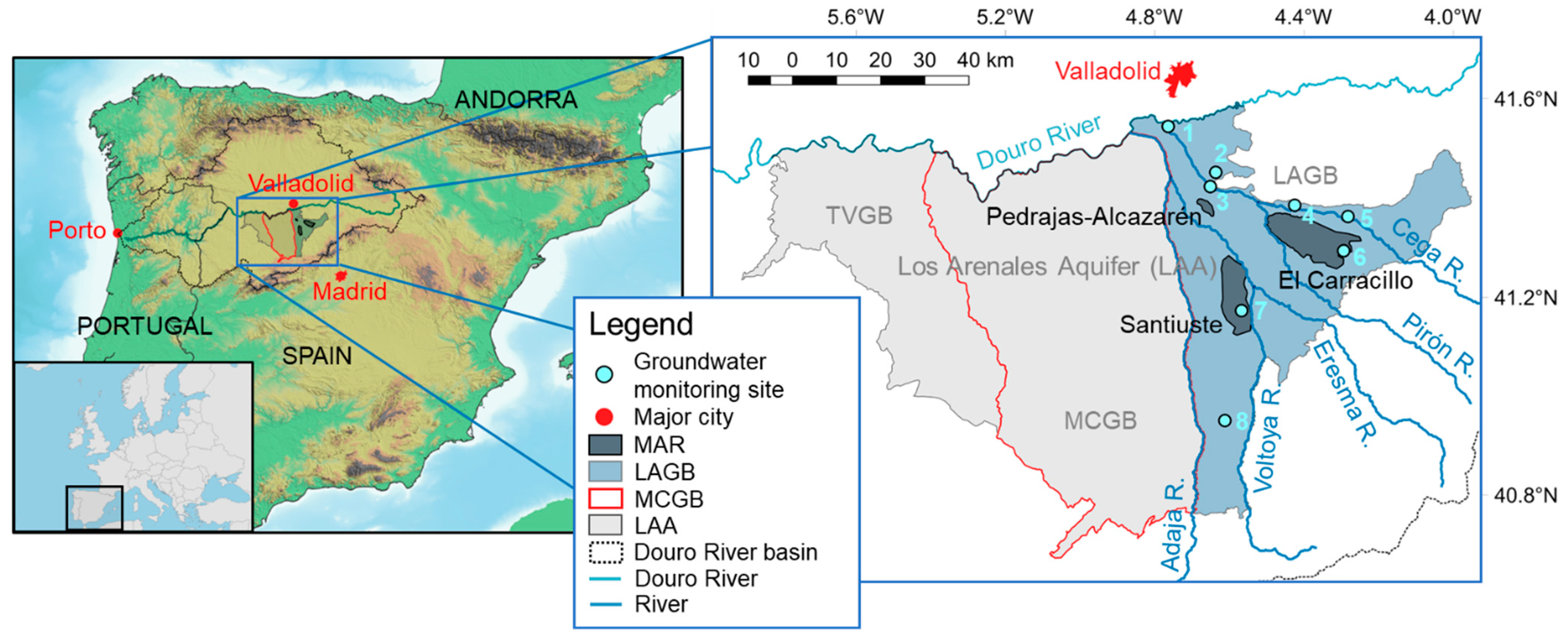
2.1. Los Arenales MAR Systems

The Los Arenales MAR systems consist of a series of small pilot schemes and three major MAR systems, namely, El Carracillo, Santiuste, and Pedrajas-Alcazarén (Figure 1). These systems are located in rural areas in southern Castile and Leon (CyL) (Central Spain). They aim to reverse the decline in groundwater storage in the Los Arenales Aquifer (LAA) and guarantee local irrigation demands. The MAR schemes recharge from river water surpluses predominantly. However, other water sources, such as rooftop runoff and reclaimed wastewater, have also been used, especially in Pedrajas-Alcazarén.
The LAA comprises two aquifer systems. The first system involves quaternary deposits and features shallow and unconfined aquifers. The second system is deeper, confined to semi-confined, and entails permeable lenses of sand and gravel embedded in an impermeable to semi-permeable matrix of silt and clay that allows for hydraulic connection [38]. The primary source of recharge for the shallow aquifer system is precipitation, while the deep system is fed by deep seepage from the shallow system. Fernández Escalante et al. [39] and Henao Casas et al. [38] provide more details about the LAA’s hydrogeology.
Following the European Water Framework Directive [40], the Douro River Basin Agency (CHD), which is the regional water authority, has divided the LAA into three groundwater bodies, namely Los Arenales, Medina del Campo (MCGB), and Tierra del Vino (TVGB) (Figure 1). This subdivision is based on several factors not limited to hydrogeology, including water management, land use pressures, and groundwater contamination and abstraction, among others [41].
Since at least 1972, groundwater levels in the LAA showed a tremendous decline due to massive irrigation abstractions, which in 2002 translated into a total groundwater level drop of 30 m at the municipality of Madrigal de las Altas Torres (located in the central part of MCGB) and 27 m near the municipality of Mojados (Figure 2) (located in northern LA, groundwater monitoring station 1, Figure 1). During the same period, an average drawdown of 1 m year−1 was observed in several parts of the aquifer [42]. In 1995, the LAA was officially declared provisionally over-exploited [42].
This critical situation posed a significant risk to the region’s economy, which is strongly linked to agriculture and irrigation. A farmers’ organisation, which would later become the irrigation community (IC) of El Carracillo, made a plea for the implementation of MAR systems, incentivised by feasibility studies conducted by the Spanish Ministry of Agriculture and the Castile and Leon Board (JCyL), who found favourable conditions for MAR in the southern part of the LAA [43]. The Spanish government met this petition with the Royal-Decree Law 9/1998 [44], which granted water allowances and budgetary resources to deviate water from the Cega and Voltoya rivers (Figure 1) and intentionally recharge it in the El Carracillo and Santiuste regions, respectively. The construction works started in 1999, and the first recharge cycle was conducted in the hydrological year 2002–2003. In 2012, the improvement in groundwater availability observed in Santiuste and El Carracillo and sound technical and hydrogeological conditions led to the development of a new MAR system in the vicinity of the Pedrajas de San Esteban and Alcazarén municipalities, resulting in the Pedrajas–Alcazarén MAR system.

2.2. Approach

We explore through different methodologies and sources of information how MAR has contributed to solving a series of challenges related to water resources at the regional level (Figure 3, left-hand side, blue). We also evaluate the potential impacts of CC in the region and how MAR can contribute to adapting to them (Figure 3, right-hand side, orange). In each subsection of the approach, we briefly introduce the challenge and its relevance, followed by the methodology used to assess the corresponding MAR solution. The subsequent subsections are titled following the categories in black font in the first row of Figure 3 and have a corresponding counterpart in the Results and Discussion (Section 3).

2.2.1. Groundwater Levels

We compute the average annual groundwater level in the LAGB by averaging the available groundwater levels in a given year, using observations from the groundwater monitoring sites of the CHD [45] (Table 1 and Figure 1). Between 1985 and 2001, we obtain groundwater level data from monitoring sites PZ0245004 and PZ0245005. Between 2004 and 2020, we use information from monitoring sites PC0245001, PZ0245004, PZ0245005, PZ0245011, PZ0245013, PZ0245017, PZ0245031, and PZ0245036. We found data gaps in all monitoring sites in the years 2002, 2003, and 2011. Even though there are more groundwater monitoring sites with available observations in the zone, we restricted the selected data to a few stations that had consistently sampled groundwater levels throughout the period analysed.

2.2.2. Energy Cost

We estimate the hypothetical extra cost and CO2 emissions caused by groundwater pumping in the LAGB if MAR was not implemented. We decrease the groundwater levels in each of the wells in the 2021 groundwater abstraction database [46] by 27.4 m, assuming that the decrease observed between 1985 and 2001 (i.e., 1.37 m year−1) continued in the period 2002–2021. Subsequently, we estimate the abstraction cost and energy consumption using an average groundwater pumping efficiency for crop irrigation in Spain (56%) [47,48]. To estimate CO2 emissions, we employ equivalent CO2 emission factors. The computed emissions are increased by 45%, corresponding to the percentage of illegal abstractions in the LAGB concerning legal groundwater rights [49].
We considered two scenarios to estimate energy cost and CO2 emissions. In one of them, 100% of the energy is produced by different energy sources (i.e., energy mix) and delivered by the Spanish electrical grid. In the other scenario, 100% of the energy is generated through diesel. We obtained the average cost of pumping groundwater through the energy mix (EUR 0.00081 m−3 m−1) and diesel (EUR 0.00168 m−3 m−1) in CyL from the Castile and Leon Institute of Agricultural Technology (ITACYL) [50]. We selected CO2 emission factors for diesel and the energy mix of 0.27 [51,52] and 0.25 [53], respectively.

2.2.3. Rural Population

Maintaining life in rural Spain is considered crucial. In the second half of the 20th century, the country experienced a decline of about 40% in rural population, resulting in a loss of economic dynamism [54]. Modernising agriculture through irrigation is considered a key approach to preventing rural exodus [55].
We analyse the development of rural population and irrigation in absolute values and as a share of the total agricultural land use in the study area. We collect the population time series of CyL and the municipalities within the zones benefiting from MAR between 1996 and 2021 from the National Statistics Institute (INE) [56]. We obtain the irrigated land area in the site from the Land Distribution Statistics of the JCyL [57]. We complement this data with land use information from CORINE Land Cover (CLC) [58] and the Spanish Land Occupancy Information System (SIOSE) [59], which allow us to analyse changes in irrigated land between 1990 and 2006 and 2005 and 2014, respectively.

2.2.4. Surface Water Bodies

During the last quarter of the 20th century, groundwater-dependent lakes and wetland bodies shrunk considerably or disappeared in the LAA. This situation was particularly dramatic in the MCGB, where surface water bodies have not recovered [60,61,62]. The reduction of wetlands, streams, and lakes is a consequence of falling piezometric levels predominantly. It results in a decrease in the delivery of ecosystem services in the area, reduced water security, and higher water extraction costs [62,63,64,65,66,67].
We review the experience of restoring La Iglesia Lake in the study area through MAR. La Iglesia Lake represents one of the few occurrences of endorheic soda lakes in Europe and has developed some degree of endemism [68].

2.2.5. Groundwater Governance

One of the major challenges Spain faces concerning groundwater management is the control of illegal abstractions. Since the Spanish Water Act of 1985 (Law 29/1985), water has been considered a public good in Spain. The transition from private ownership to the water allowance model has overflowed the ability of water management authorities to grant water rights and monitor their compliance, resulting in weak territorial control and an ambience that favours unauthorised groundwater extraction [69,70].
We discuss the benefits of ICs on groundwater governance and security in the LAGB and their vital role in decreasing unregulated groundwater consumption. The improvements in water governance discussed are based on workshops conducted with decision agents during the DINA-MAR and MARSOL projects [42,61]. For the sake of contrast, we also draw elements from workshops conducted in MCGB, where an IC has been recently stablished [61,71].

2.2.6. River Flows

According to Representative Concentration Pathway (RCP) 8.5 climate projections by Guerreiro et al. [72] and Cruz-García et al. [73], the Douro River flow is expected to decrease by around 71% in autumn and up to 91% in winter. A similar decrease could occur in the rivers providing water for MAR under the expected decline of precipitation by 5% in the Douro River basin [74].
We estimate the volume of wastewater produced in the LAGB that could be treated and recharged in the Los Arenales MAR systems, potentially replacing river water as the main source in the face of decreasing river flow. We consider two primary sources of wastewater: (i) household and industrial sewage and (ii) stormwater. We estimate the wastewater produced by industry and households in each municipality through Equation (1).
V R = V D   P   D F   ( 1 S L )
where VR is the household and industrial sewage potentially available for reuse, VD is the average drinking water supply per inhabitant per year (170 litres/inhabitant day for urban areas with little commercial activity [75]), P is the population, DF is the discharge factor representing the fraction of drinking water that goes into the sewage system (80% [76]), and SL is the sewage system losses (15%). We estimate the reusable wastewater in the LAGB by adding the individual contributions of the municipalities in the region, computed through Equation (1). We obtain urban agglomerations in the LAGB and their corresponding populations from the 2018 Geographic Information Database of Reference Populations of the National Geographic Institute (IGN) [77].
We estimate stormwater as the product of the average annual precipitation and the urban area, considering paved surfaces such as roads and rooftops. We compute the average annual precipitation in the LAGB using Thiessen polygons [78] and rainfall data between 1985 and 2020 from meteorological stations of the Spanish Meteorological Agency (AEMET) [79] (2444, 2422, 2150H, 2503X, 2117D) and InfoRiego [80], a system for irrigation recommendation by the Spanish Ministry of Agriculture and the JCyL (SG01, SG02, VA102, VA03, VA06, AV01). We use three information sources to obtain urban area, resulting in three estimations of potentially recyclable stormwater: continuous and discontinuous urban fabric area from (i) SIOSE and (ii) CLC for 2014 and 2018, respectively, and (iii) 85% of the urban agglomeration area reported in the Geographic Information Database of Reference Populations by the IGN, assuming that the remaining 15% of the area corresponds to green urban spaces [81].

2.2.7. Droughts

The frequency and impact of drought in the Douro River basin are expected to increase. According to climate model simulations, Guerreiro et al. [82] found that, in most of the models they employed, around 80% of the basin was projected to experience extreme drought by the end of the century. Furthermore, Amblar Francés et al. [74] observed an increase in temperature of between 4 and 6 °C, a lengthening of the dry period by four days, and a decrease in precipitation at 5% by the end of the century relative to the reference interval (1961–1990) under RCP 8.5. These impacts of CC will impact the agricultural sector, which is fundamental for the Douro River basin. For instance, Cerdá et al. [83] identified a likely decrease of 40.5% in olive yield due to the pressure on water resources resulting from the increasing risk of drought.
We highlight some aspects of the work by Henao Casas et al. [38] and Fernández Escalante et al. [37], who proved that MAR in the LAGB contributes to mitigating the impacts of water scarcity and drought.

2.2.8. Floods

Long-duration rainfall, thawing, and high-intensity precipitation are the leading causes of flooding in the Douro River basin [84]. In the study area, floods have occurred with more frequency in the basin of the Cega River (1948, 1961, 1962, 1966, 1970, 1995, 1996, 2013, and 2014 [84,85]), which feeds the El Carracillo MAR system. These flooding events have affected the municipalities of Viana del Cega and Mojados multiple times. Climate change simulations by Amblar Francés et al. [74] predict that these extreme events and the ensuing consequences might be more frequent between 2081 and 2100. Their RCP 8.5 projections show that three basins in Spain will likely experience higher-intensity precipitation, with the Douro River basin at the top, nearing an 8% increase compared to the reference period (1961–1990).
We use Google Earth satellite images and design details of the MAR infrastructure to quantify the total water volume that can be held in the El Carracillo MAR system in case of flooding. For the infiltration channels, we assumed a minimum channel width of 2.5 m and slopes extending three meters horizontally and two vertically [42,86]. We compute volumes considering the maximum ponding depth of 2.5 m recommended by the Spanish Ministry of Agriculture, Fisheries, and Food (MAPA) for these rural structures [86]. We evaluate the estimated volume in the context of the 2013 flood that affected Viana del Cega and Mojados, two municipalities located downstream of the El Carracillo MAR system. We also examine the work by San Sebastián Sauto et al. [87] concerning the potential of decreasing the impacts of floods in the Voltoya River basin by diverting peak flow to infiltration basins and channels of the Santiuste MAR system.

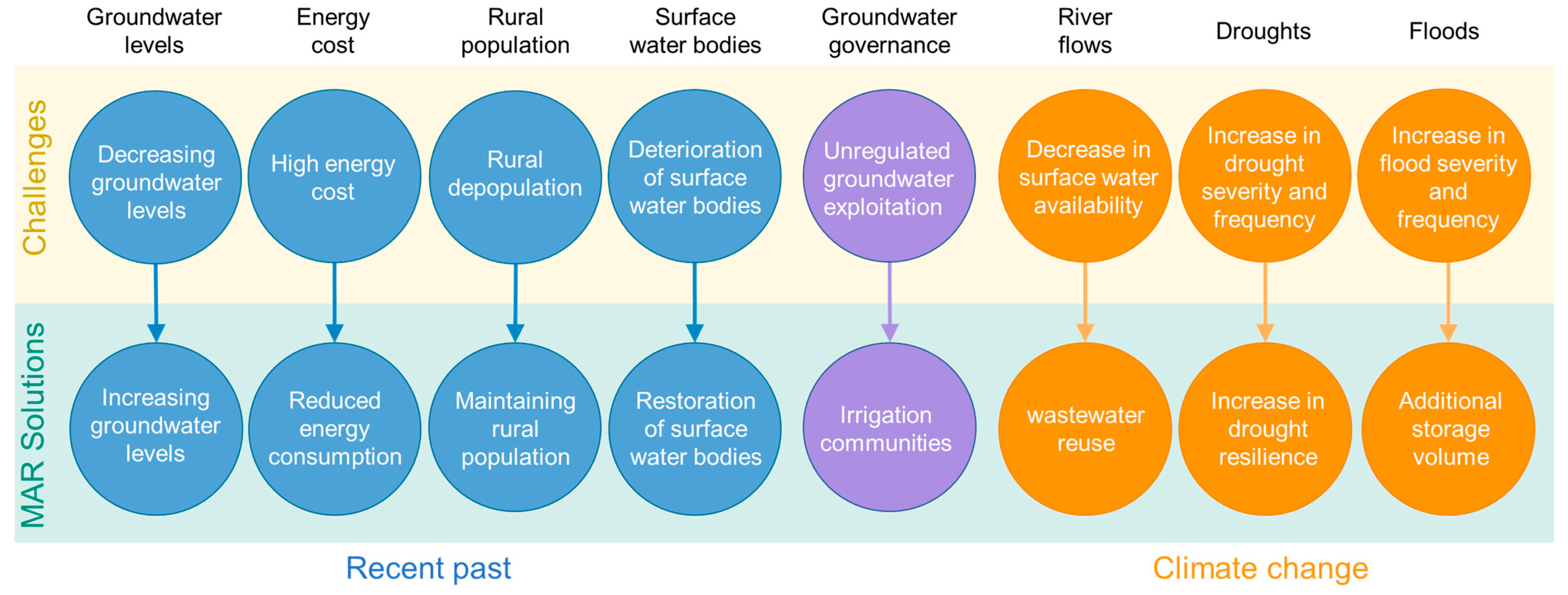
3. Results and Discussion

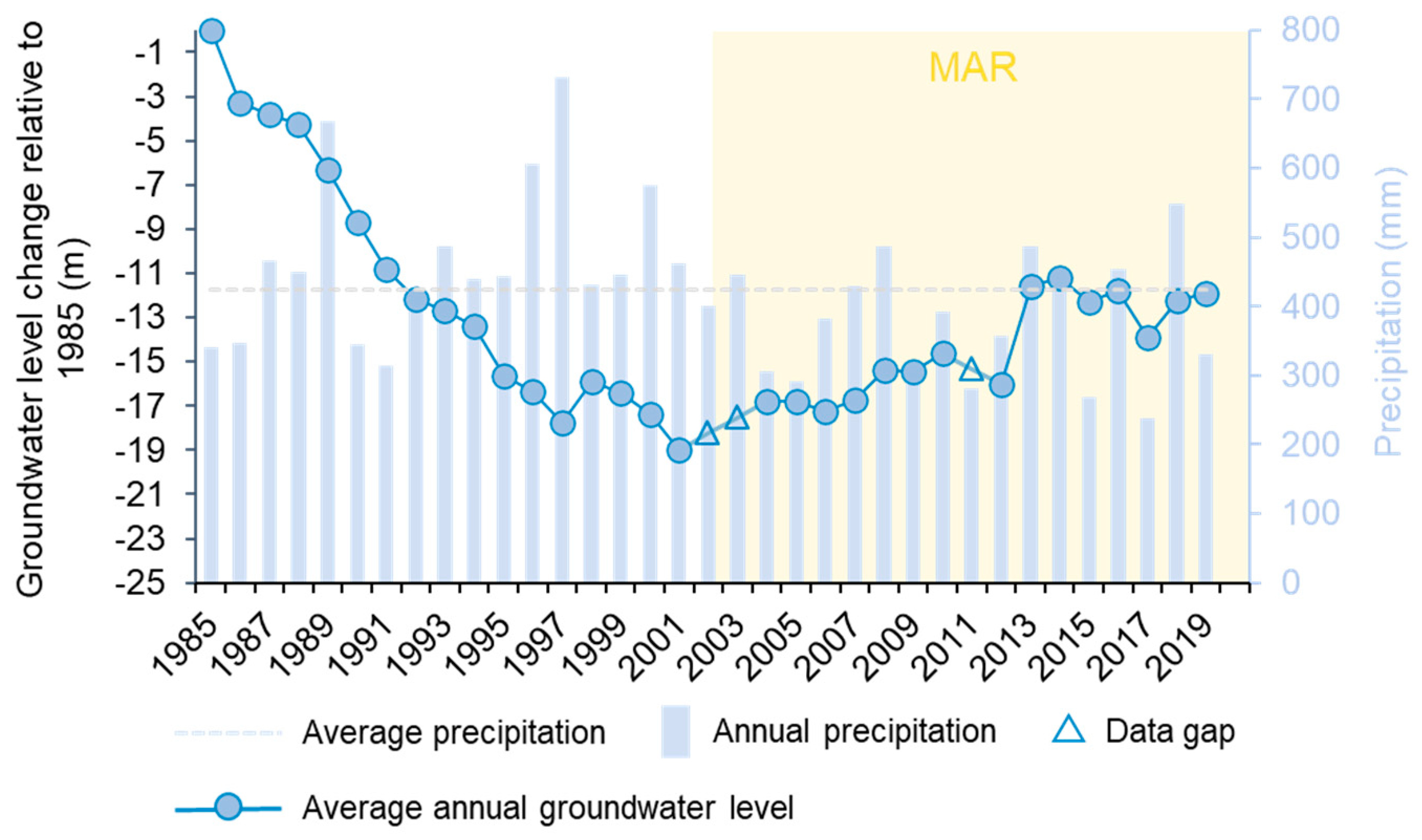
3.1. Groundwater Levels
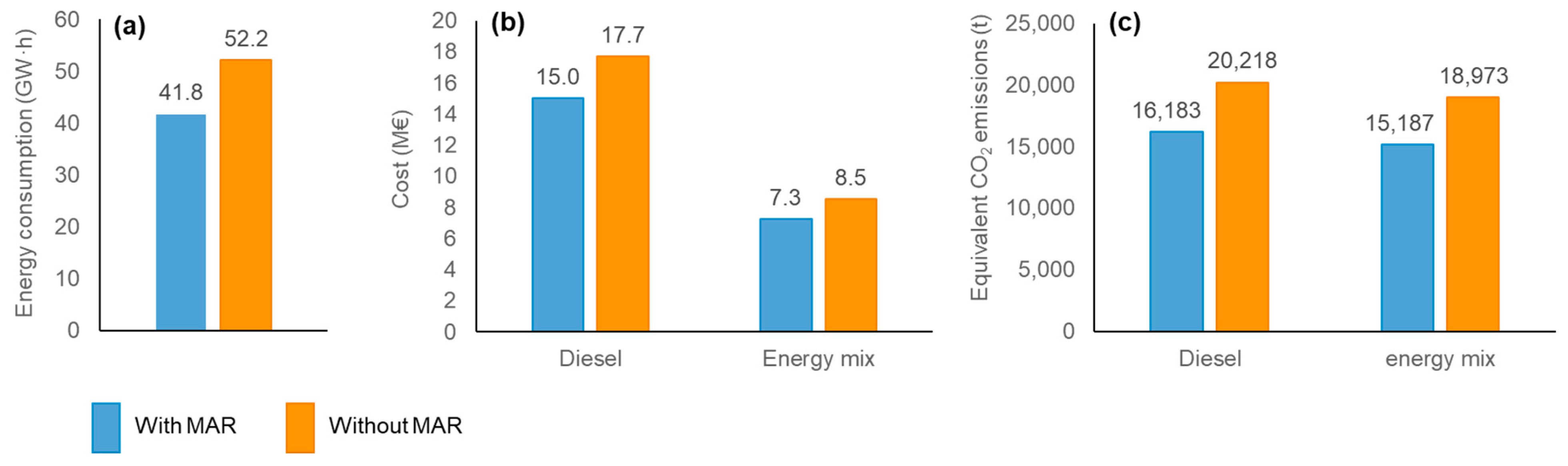
Average annual groundwater levels in the LAGB steadily decreased at −1.37 m year−1 between 1985 and 2001 (Figure 4). At some point between 2001 and 2004, a period that includes the inauguration of the largest MAR systems in the LAGB (Santiuste and El Carracillo), the trend turns positive, and piezometric levels increase at about 0.3 m year−1 on average (Figure 4). Such an increase occurs despite lower average precipitation between 2004 and 2020 (378 mm year−1) compared with precipitation in the previous period, i.e., 1985–2003 (464 mm year−1). Henao Casas et al. [88] proved that MAR is the only measure capable of improving the storage of the LAGB to the extent reflected in Figure 4. The DINA-MAR and MARSOL research projects [55,89] also demonstrated that multiple piezometers in Santiuste have an increasing trend, and farmers show a very favourable perception of MAR in terms of groundwater storage recovery.
The recovery in groundwater levels is the keystone of other MAR benefits that are subsequently explored, including savings in water pumping energy, a decrease in CO2 emissions, an expansion of the irrigated frontier, and the consequent improvements in the living conditions of farmers, among others.

3.2. Energy Cost

If MAR was not implemented, groundwater pumping would result in about 22% higher energy consumption (52.2 GW·h without MAR vs. 41.8 GW·h with MAR) (Figure 5a), farmers would have to spend 16% more economic resources to pump the same water volume either through diesel or the energy mix (Figure 5b), and CO2 emissions would be 22% higher regardless of the energy source (Figure 5c). Villamayor-Tomas [90] found that approximately 70% of the energy consumed in the Spanish irrigation sector comes from the electrical grid. Thus, the total pumping energy cost and CO2 emissions values are closer to the energy mix scenario. Previous studies by Fernández Escalante et al. [37] point out that gravity conveys water to the MAR systems, resulting in additional energy savings by avoiding surface water pumping. The same study also found that an increase of 2.3 m in groundwater levels in El Carracillo saved 12–36% in groundwater pumping energy, cut CO2 emissions by about 11 tonnes, and reduced farmer’ energy bills by EUR 3000 per year.

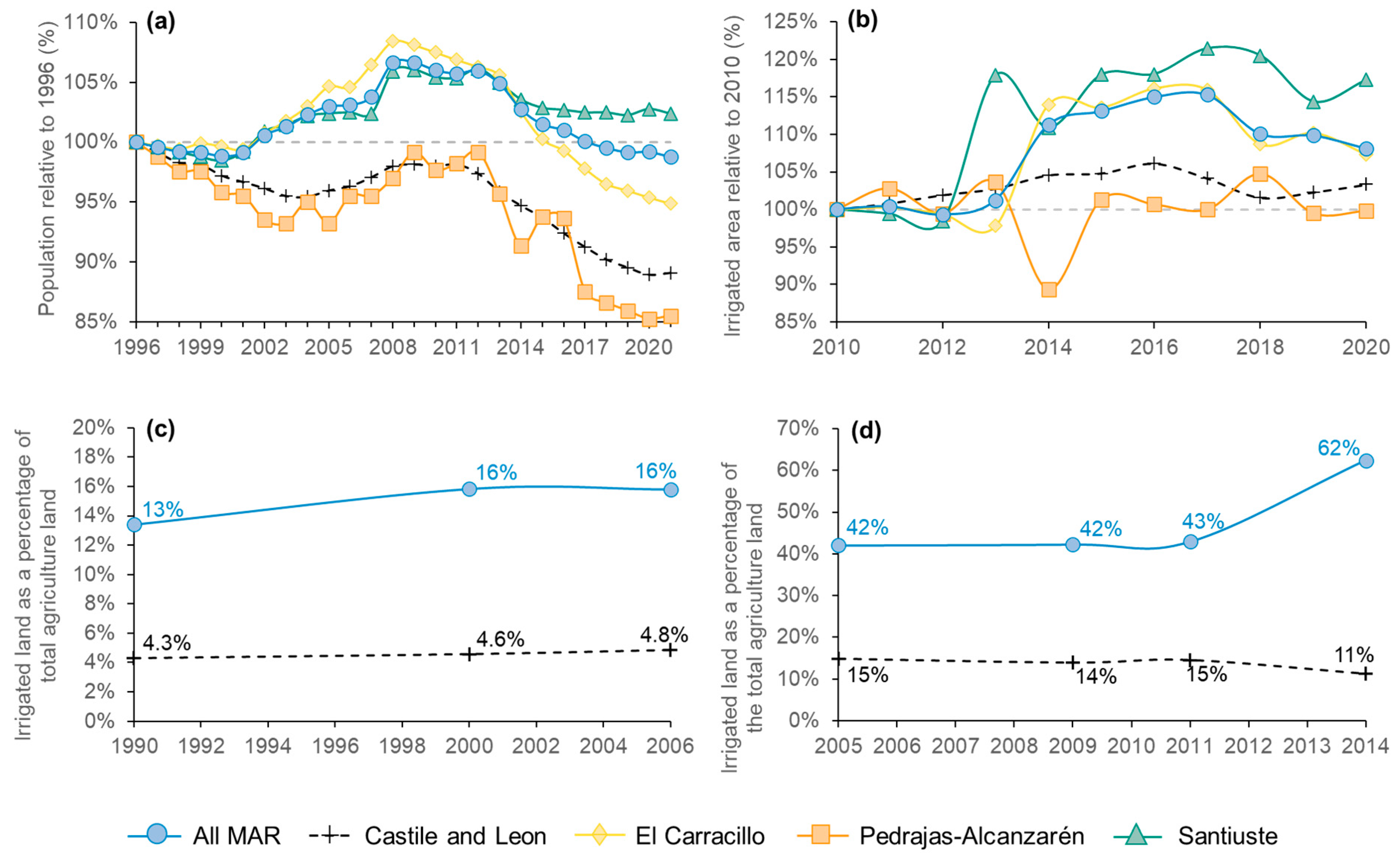
3.3. Rural Population

In areas where MAR is implemented, the population in 2020 was nearly the same as in 1996 (Figure 6a). In contrast, the population in CyL and the Pedrajas-Alcazarén MAR system has an overall decreasing trend between 1996 and 2020, resulting in a population drop of 10 to 15% relative to 1996 (Figure 6a).
The total irrigated land in areas with MAR is at least three times larger than in CyL in the periods 1990–2006 (Figure 6c) and 2005–2014 (Figure 6d). The differences in irrigated land in absolute and percentual values between CLC and SIOSE derive from the different methodologies they entail to categorise land use. This is the main reason we did not merge Figure 6c,d. The curves of irrigated land over time are not temporally correlated to milestones associated with MAR implementation. However, MAR has contributed to sustainably maintaining irrigation, supporting the observed expansions of irrigation in 2000 (3%) and 2014 (19%) (Figure 6c,d) without further detriment to groundwater levels in the area (Figure 4). Furthermore, in regions where MAR implementation has been successful, namely, El Carracillo and Santiuste, the irrigated area has increased by 10–15% in 2022 relative to 2010 (Figure 6b).
The increase in irrigated land directly impacts the local job market and, consequently, the population. According to the JCyL, in CyL, irrigation produces 3.5 times more revenue, results in three times the population, and generates 3.6 times more jobs than rainfed agriculture [54]. Irrigated agriculture also accounts for a sizeable proportion of the commodities used by the local agrifood industry, which specialises in the packaging and transformation of agricultural products, notably vegetables, such as carrots and sugar beets. In El Carracillo, most agribusiness products are exported to the UK, France, and Italy, generating a revenue of around EUR 50 million in 2016. Furthermore, in this region, there are about three times more workers and nearly 2.8 more enterprises per unit area than in CyL, much of it related to the agrifood industry [42]. Based on the above evidence, we believe that the effect of MAR has been to provide irrigation sustainably and consequently contribute to generating economic dynamism and retaining the rural population. The deficient performance of the Pedrajas–Alcazarén MAR system in terms of population and irrigated land is a consequence of a ban on Pirón River water diversion due to administrative conflicts of interest and using little rooftop runoff due to water quality constraints. To date, the system relies almost exclusively on treated wastewater.
Fernández-Escalante and López-Gunn [61] summarised some socio-economic benefits of the Los Arenales MAR systems and compared them with the region of CyL for reference. These benefits include a high-density working-age population (17 inhabitants km−2 in areas with MAR vs. 7.4 inhabitants km−2 in CyL) and a rural population increase (+28% in areas with MAR vs. −6% in CyL).

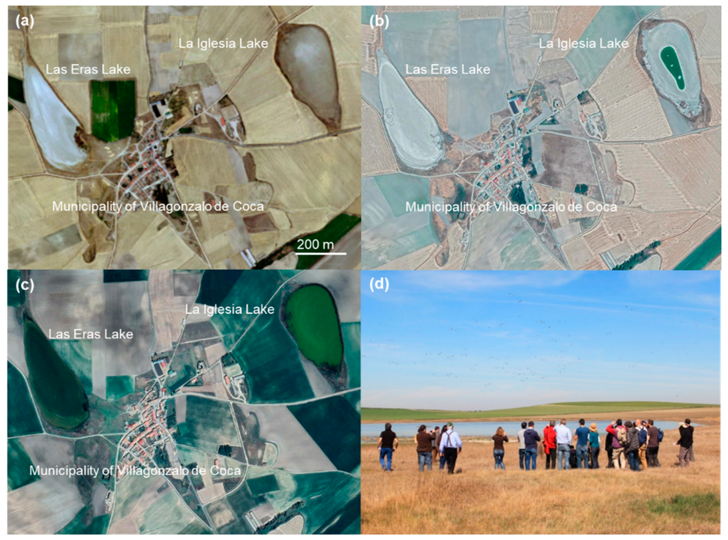
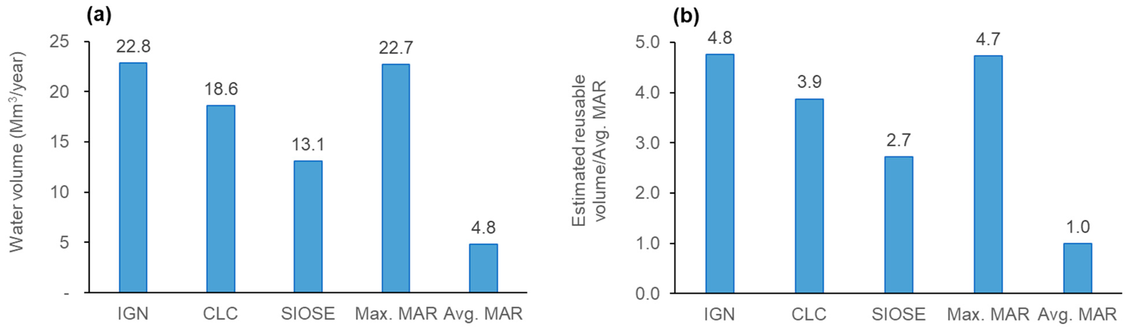
3.4. Surface Water Bodies

Before the decrease in groundwater levels witnessed in the second half of the 20th century and the virtual disappearance of wetlands and lakes bound to the LAA (Figure 7a), La Iglesia Lake was supplied by regional groundwater flow with a long trajectory [39]. High evaporation rates concentrated the basic salts contained in the source water, increasing the pH (>9.5 [91]). To emulate this process and maintain the lake’s dependent ecosystem (Figure 7b), around 5% of the surface water conveyed from the Voltoya River to the MAR system in Santiuste is deviated to La Iglesia Lake [42]. The system’s water spillway maximises the contact between the Voltoya River water and the sediments on the lake beach, ensuring water quality close to the original conditions and the alkaline pH that characterises this water body [89]. During the wettest period of the year, the lake reaches an extension of around 65,000 m2 and a depth < 1m (Figure 7c,d).
Maintaining the lake’s pristine condition is crucial to supporting multiple lifeforms. Studies conducted in Las Eras Lake (Figure 7a–c) have shown the ubiquitous presence of cyanobacteria mats and biogenic sedimentary structures, which serve as a modern analogue to study and reconstruct the paleoenvironment of endorheic soda lakes in the geological past [68,92]. Furthermore, Las Eras Lake supports populations of ostracods, cyanophytes, and the green algae Chara canescens with unique morphological characteristics [93]. Given their proximity, similar environmental and hydrogeological conditions, and the occurrence of bioindicators, La Iglesia Lake likely shares these biological features with Las Eras Lake.
La Iglesia Lake also serves as a refuge for waterfowl. Bird counting conducted in 2007, 2012, and 2015 has shown the presence of at least 25 species. Three of them, namely, the wild duck (Anas platyrhynchos), the black-winged stilt (Himantopus himantopus), and the northern shoveler (Anas clypeata), have been sighted consistently. The latter two species use the lake as a refuge during migration.
The minerals in the lake are truly relevant from a geological standpoint. With high water stage and low temperatures, sodic carbonates precipitate, including natron (Na2CO3·10 H2O) and trona (Na3(HCO3)(CO3)·2H2O), which are rare in Europe [68].
The lake also offers landscape and recreational value for the local population and visitors [42] (Figure 7d). Nonetheless, in years when low ecological flow in the source river precludes MAR (e.g., the hydrological year 2011–2012), the lake is not fed, a drawback expected to be solved by continuously increasing groundwater levels. In addition to La Iglesia Lake, the MAR systems in the LAGB involve five artificial wetlands that improve water quality.

3.5. Groundwater Governance

Following the Spanish Water Act of 1985 (updated in 2001 through the Royal Decree 1/2001 of 20 July), users’ organisations must be formed to establish direct communication and cooperation between regional water authorities and water users under three scenarios: (i) when users benefit from the same water intake or concession (art 81.1); (ii) when an aquifer has been declared over-exploited, or a groundwater body might fail to meet the objectives of the Water Framework Directive [94]; and (iii) for the authorisation of any large-scale river water diversion for artificial recharge.
Users’ organisations are called irrigation communities (ICs) when irrigation is the end use of water allowances and groundwater user communities when nearly 100% of the water granted is extracted from the subsurface. In the LAGB, users’ organisations correspond to both groundwater user communities and irrigation communities. For reasons of tradition, farmers have chosen to set up “irrigation communities” in the study site. Three ICs have been established in the LAGB: the El Carracillo Irrigation Community, the Cubeta de Santiuste Irrigation Community (formally the Cubeta de Santiuste de San Juan Bautista, Villagonzalo de Coca, Ciruelos de Coca, and Villeguillo irrigation community), and the Alcazarén Association of Commoners, which gather 713, 440, and 190 farmers, respectively [61].
Every year, the CHD assesses the water volume conveyed from the river source to the MAR systems and accordingly grants water rights to the ICs. The ICs set rules to distribute these water rights and report to the water authority on water use. This process occurs predominantly via meetings between the CHD and representatives of the IC and between these representatives and the IC members. Concerning finances, the MAR systems in the LAGB were funded by the national government. However, the ICs benefiting from MAR have the legal obligation to operate and maintain the infrastructure for 35 years. IC members pay annual fees to meet these legal obligations and administrative costs. This groundwater allocation scheme constitutes a co-managed institutional arrangement where the state and users share responsibilities. For the particular case of the LAGB, which involves MAR, this scheme has also been called Co-Managed Aquifer Recharge (Co-MAR) [61].
The ICs improve groundwater governance and water security due to the transparency in the water allocation process, the active information exchange among decision agents, and the shift in farmers’ mindset from individual to collective action. Moreover, legally binding ICs to the conservation and performance of MAR infrastructure is crucial for successfully co-managing water resources. We illustrate these dynamics through a simple process diagram based on stakeholder workshops conducted in Los Arenales and Medina del Campo groundwater bodies during the DINA-MAR, MARSOL, and NAIAD projects [42,61,71] (Figure 8a,c). We also show the situation when ICs are not conformed (Figure 8b,d), following the agent-based/system dynamic model by Giordano et al. [71] built to assess the implementation of nature-based solutions in MCGB.
ICs create a platform for assessing and distributing water rights, increasing transparency in the process, and building an environment of trust (Figure 8a). They also ease the bidirectional exchange of information between the water authority and farmers for better decision-making based on factual data. Under such circumstances, farmers are more likely to abide by the water rights assigned, cooperate, and perceive that the CHD has a more robust territorial control, which deters illegal groundwater abstractions (Figure 8a). On the contrary, without ICs, water users see the traditional top-down approach to granting water rights as unfair and not entirely transparent, resulting in a lack of trust in the water authority and the notion that its territorial control is weak (Figure 8b). This ambience promotes individual behaviour, less acceptance of water rights, and ultimately, groundwater overdraft (Figure 8b) [71].
ICs play the additional role of enabling interaction among farmers and increasing their social capital (Figure 8c). Since farmers in the area tend to adopt the predominant cropping behaviour they observe in their communities, they can find innovation and technical support in the ICs to cope with adverse conditions, such as low water availability or unfavourable market prices (Figure 8c). In contrast, farmers with low social capital act as isolated agents and have less chance to discover strategies to grapple with market and environmental difficulties. The lack of innovation sometimes equals maintaining cropping patterns that are not sustainable, which can have an adverse impact on groundwater resources and the environment (Figure 8d) [71].
ICs are an instrument to solve conflicts among farmers [55] and exchange points of view with actors that advocate for a different and sometimes opposite use of water resources, such as environmental protection organisations and downstream water users (e.g., fishermen and hydropower producers). ICs also give voice to members of society not directly involved in water use, which can deliver valuable contributions. These agents, collectively designated by Fernández-Escalante and López-Gunn as “stakehomers” [61], include the local population, NGOs, researchers, and academia [42]. ICs can also collectively negotiate optimal energy supply contracts, decreasing the cost of irrigation [47]. They can ease the penetration of new farming and irrigation technologies that increase yield and water use efficiency and control (e.g., correct sizing of pumps, guidance on the installation of well flow meters, and the optimisation of irrigation systems) [61]. Some ICs are helping to improve groundwater quality by adopting internal rules and supervision mechanisms to reduce agro-chemical inputs in their plots [61].
However, members of the ICs are occasionally unsatisfied with their representatives in the governance scheme. In most cases, this situation has been solved by designating a delegate with a technical background (e.g., an independent agricultural engineer) and no conflict of interest that stands for the collective benefit [95]. Furthermore, some farmers consider the distribution of water rights unfair because everyone pays similar fees but does not receive proportional water allowances. This issue compounds when groundwater users not involved in the ICs benefit from increasing groundwater levels and storage due to MAR. Problems pertaining to the distribution of water and fair IC fees might be circumvented by considering further technical aspects during the water allocation process.
Concerning CC, ICs have also contributed to building adaptive capacity because they constitute an interlocution instrument that can be used to disseminate CC information and implement adaptation and mitigation strategies at the farmer level, such as, for instance, programs for carbon sequestration in soils through agricultural conservation practices.

3.6. River Flows

Our calculations indicate that there is likely 2.9 Mm3 year−1 of wastewater from households and industries in the LAGB. We estimated recyclable stormwater at 19.9 Mm3 year−1, 15.6 Mm3 year−1, and 10.1 Mm3 year−1, using IGN, CLC, and SIOSE urban area information, respectively. The total recyclable water lies between 22.8 Mm3 year−1 and 13.1 Mm3 year−1 (Figure 9a). The potentially reusable wastewater is between 4.8 and 2.7 times the average MAR in the period 2002–2020 (Avg. MAR, Figure 9a,b).
If the actual urban area in the LAGB corresponds to the value reported by the IGN, the estimated reusable water (22.8 Mm3 year−1) could cover the maximum allowed annual diversion of river water for MAR in EL Carracillo (14.2 Mm3 year−1) and Santiuste (8.5 Mm3 year−1) combined (22.7 Mm3 year−1) (Max. MAR, Figure 9a,b). Note that the maximum allowed annual diversions of river water for MAR constitute a limit aiming to respect ecological flow and downstream users. Actual diversion volumes are often <50% of the maximum allowed volumes. Some of the estimated recyclable water might not be harnessed due to water quality issues or logistical, practical, and financial constraints, as well as further losses in the collection system or to evaporation.
Replacing river water surpluses with recycled wastewater entirely or partially could also contribute to increasing water security against drought, which can further deplete available surface water in the area.
There is a need for wastewater treatment in CyL, and a favourable technical and regulatory environment for reuse. In this region, 50% of small villages (>2000 equivalent inhabitants) lack wastewater treatment [96]. This situation breaches the European directive 91/271/ECC [97] (adopted in the Spanish regulation through the 11/1995 Royal Decree [98]), which requires adequate wastewater treatment in nearly all urban agglomerations by 1 January 2006, at the latest. Furthermore, planning wastewater treatment with a focus on reuse in villages lacking this service would align with Spanish and European efforts towards a circular economy, including one of the first regulatory frameworks for wastewater reuse (Spanish Royal Decree 1620/2007 [99]), two national plans for recycling water (The National Water Reuse Plan 2010–2015 and the National Plan for Purification, Sanitation Efficiency, Saving, and Reusing [100]), and the European Directive on Minimum Requirements for Water Reuse [101]. Similarly, Spain has an extensive experience in this regard, as one of the top ten countries in water reuse percentage worldwide and the country with the highest wastewater reuse rate in the European Union [102].

3.7. Droughts

Henao Casas et al. [38] examined the efficacy of MAR in coping with drought in the LAA. They compared the response of LAGB and MCWB to drought by computing parameters on groundwater level time series, which were detrended and consequently free of influence from MAR and other anthropogenic impacts. The parameters computed were derived from the Standardised Groundwater Level Index (SGI) [103], including mean drought duration and magnitude. The LAGB showed less frequent below-average water conditions but a higher propensity to prolonged droughts and, ultimately, a larger water deficit due to dry spells than MCGB. In the absence of significant differences in water management practices between LAGB and MCGB, and in light of faster-recovering groundwater levels in the LAGB, they concluded that MAR contributes to diminishing the impact of drought and water scarcity in the area.
Fernández Escalante et al. [37] proved that MAR in the LAGB helps palliate decreasing soil moisture caused by increasing temperature and below-average precipitation. This effect of MAR was more tangible in areas close to the infiltration infrastructure during recharge cycles and could benefit agricultural land near MAR systems by maintaining high soil moisture beyond the rainy season.

3.8. Floods

The total storage capacity of artificial wetlands, infiltration basins, and infiltration channels in the El Carracillo MAR system is at least 0.33 Mm3. This storage could hold for about 6.5 h the peak flow volume (14.1 m3 s−1) circulating in the Cega River during the 2013 flood that affected Viana de Cega and Mojados. Thus, the system could help to mitigate flooding. Still, its capacity is limited and likely requires the implementation of additional solutions with larger storage volumes (e.g., the adequation of extensive flooding plains or dykes).
The potential water volume that can be held in the El Carracillo system would increase considering underground storage, which is, however, constrained by the onset of waterlogging, which can occur quickly during the rainy season [89,104]. Two critical factors limit the storage of water in the El Carracillo system. The first one is the capacity of the water conveyance pipe from the Cega River. Flooding requires a rapid decrease in river water flow, and 1.3 m3 s−1 is a limited water withdrawal volume compared to the peak flow registered during the 2013 Cega River basin flooding (i.e., 14.1 m3 s−1). Water infiltration rates are also low compared to flood peak flow, and thus, limit the use of underground storage. Increasing the capacity of the El Carracillo MAR system’s water conveyance pipe could augment its efficacy in mitigating floods. However, a more precise appraisal of this potential use requires detailed modelling, economic, and hydrological studies.
San Sebastián Sauto et al. [87] explain that the Santiuste MAR system has two spillways that allow for draining of infiltration channels and agricultural drains to prevent waterlogging and flooding, particularly under high-intensity precipitation events. The same authors suggest that the spillways have the potential to accommodate up to 1 m3 s−1 from the Voltoya river (Figure 1) (which is the water source for MAR) in case of flooding. They also estimated an additional storage capacity in infiltration basins and artificial wetlands of 19,822 m2, which, assuming a maximum ponding depth of 2.5 m (the same water height considered in the calculations for the El Carracillo MAR system), corresponds to 0.05 Mm3.

3.9. General Discussion and Outlook

MAR systems in the LAGB are a good example of low-regret adaptation measures. These systems have resulted in multiple benefits and have increased CC adaptive capacity in the area. Even if the climate does not change, the investment in MAR is justified under the present climate conditions. Although the Los Arenales MAR systems were formulated as a bottom-up approach, they were concerned with CC from the beginning. Along with providing means for irrigation, these systems were also conceived to buffer extreme climatic events [44].
Our research shows that low-regret measures can bridge the gap between adaptation approaches. However, considering current stresses and future climate change scenarios could result in more robust and holistic solutions [8,18,105]. For instance, the MAR system in El Carracillo perhaps fell short of providing a more efficient flood solution through a water conveyance pipe with a larger capacity. Formulating this MAR system in consideration of multiple uses, pressures, and detailed CC scenarios could have helped to refine some design and operational aspects further and probably resulted in an optimal capacity to address flooding events. However, it is possible that preliminary studies also considered these factors [104,106], but detailed information is not available.
Low-regret measures are remarkably competent in developing countries, rural areas, and regions lacking long-term monitoring data that allow projecting climate into the future without significant uncertainty.
Developing countries are more vulnerable to CC and likely to bear the worst consequences [107,108,109]. At the same time, these countries often suffer the so-called “adaptation deficit”, characterised by underinvestment in the infrastructure required to deal with natural climatic variability [14,21]. Developing countries are also undergoing rapid changes, such as population growth and urbanisation, adding to the climate-related stresses above [8]. This ambience is favourable to low-regret solutions, which could help to bridge the adaptation deficit, contribute to solving economic, environmental, and demographic challenges, and simultaneously increase CC adaptive capacity.
In developing and developed countries, rural communities are more vulnerable to CC than their urban counterparts (especially rural communities depending on agriculture) due to factors such as lower per capita income, lower employment rates, lower educational attainment, demographic ageing, reduced access to health, limited access to markets, and reduced landownership, among others [110,111,112]. Low-regret measures, including MAR, can significantly improve some of these conditions, for instance, by enabling irrigation and delivering adaptive capacity simultaneously, as shown in this study.
Despite the visible benefits of low-regret measures, there are instances in which these measures may fall short of tackling the effects of CC, and less reversible and expensive alternatives must be implemented. For instance, in some cases, the need for implementing a sea-level wall or resettling populations in areas of high climatic risk might be well justified, despite the high regret implied in the required investment. In addition, as far as MAR relies predominantly on river water surpluses, multi-year droughts pose a major threat to the viability of the technology and the mid- and long-term operation of the systems. During dry hydrological years, such as 2004–2005, 2007–2008, and 2011–2012, water was not diverted to some of the MAR facilities in the LAGB due to low flows in the source rivers. Furthermore, MAR systems are not a panacea to water-related issues and can work best when accompanied by sound integrated management of water resources and other solutions, including the conjunctive use of groundwater and surface water [113], water demand control [61,88,114], multi-level governance, spaces that create trust among decision agents [61], and water reuse [115], among others.

4. Conclusions

Through a series of indicators and analyses of the Los Arenales MAR systems, we have shown that managed aquifer recharge (MAR) can be framed as a low-regret measure to adapt to climate change (CC), providing solutions to climate-related issues and building adaptive capacity against CC. Additionally, we have demonstrated that low-regret measures have the potential to mitigate climate change via a reduction in CO2 emissions.
In particular, MAR in the Los Arenales groundwater body (LAGB) has helped to: reverse the groundwater level trend around 2003, from −1.37 m year−1 to 0.24m year−1; reduce energy consumption and CO2 emissions by about 22% and pumping costs by 16%; maintain nearly the same population registered in 1996 in areas with MAR, in contrast to a regional drop of about −10%; increase the irrigated agriculture frontier by 10–15% between 2010 and 2022; restore a natural lake that hosts endemic lifeforms and rare minerals, and serves as a refuge to multiple bird species; and create irrigation communities, which establish a direct channel of communication between water authorities and farmers, enhancing water security and building CC adaptive capacity.
In terms of attributes to cope with CC, the Los Arenales MAR systems can further help buffer water resources against water scarcity and dry spells through wastewater recycling under the threat of declining source river flow. To date, wastewater in the region is 2.7–4.8 times the average water withdrawal from river sources for MAR; the Los Arenales MAR system can also contribute to mitigating floods and increase resilience against water scarcity and drought, as proved in this research and previous studies.
Low-regret solutions, such as MAR, are a good compromise between bottom-up and top-down CC adaptation approaches, resulting in win-win scenarios regardless of CC evolution. These adaption solutions are particularly suitable in developing countries and rural areas, which are more vulnerable and are often afflicted by underinvestment in adapting to long-term climate variability.

Author Contributions

Conceptualisation: J.D.H.C., E.F.E. and F.A.; methodology: J.D.H.C.; validation: all; formal analysis: J.D.H.C.; investigation: J.D.H.C.; resources, all; data curation: J.D.H.C. and E.F.E.; writing—original draft preparation: J.D.H.C.; writing—review and editing: all; visualisation: J.D.H.C.; supervision: E.F.E. and F.A.; project administration: R.C.G.; funding acquisition: E.F.E. All authors have read and agreed to the published version of the manuscript.

Funding

The research leading to these results has received funding from the European Union’s Horizon 2020 research and innovation programme under The Marie Skłodowska-Curie grant agreement No. 814066 (Managed Aquifer Recharge Solutions Training Network—MARSoluT) (https://www.marsolut-itn.eu/ (accessed on 10 November 2022)).

Data Availability Statement

Not applicable.

Acknowledgments

Special thanks to the Duero River Basin Agency (CHD), the Castile and Leon Board (JCyL), the Castile and Leon Institute of Agricultural Technology (ITACYL), and the irrigation communities of the Los Arenales groundwater body, who made available the necessary information to develop this research. The authors also thank the three anonymous reviewers whose suggestions significantly improved this article.

Conflicts of Interest

The authors declare no conflict of interest. The funders had no role in the design of the study; in the collection, analyses, or interpretation of data; in the writing of the manuscript; or in the decision to publish the results.

References

  1. IPCC. Summary for Policymakers. In Contribution of Working Group II to the Sixth Assessment Report of the Intergovernmental Panel on Climate Change; Cambridge University Press: Cambridge, UK; New York, NY, USA, 2022; pp. 3–33. [Google Scholar]
  2. Rogelj, J.; den Elzen, M.; Höhne, N.; Fransen, T.; Fekete, H.; Winkler, H.; Schaeffer, R.; Sha, F.; Riahi, K.; Meinshausen, M. Paris Agreement Climate Proposals Need a Boost to Keep Warming Well below 2 °C. Nature 2016, 534, 631–639. [Google Scholar] [CrossRef] [PubMed] [Green Version]
  3. UN. Climate Action. Available online: https://www.un.org/en/climatechange/net-zero-coalition#:~:text=To%20keep%20global%20warming%20to,reach%20net%20zero%20by%202050 (accessed on 8 September 2022).
  4. IEA. Global Energy Review: CO2 Emissions in 2021-Global Emissions Rebound Sharply to Highest Ever Level; International Energy Agency: Paris, France, 2022; p. 14. [Google Scholar]
  5. IPCC. Annex II—Glossary. In Climate Change 2014 Impacts, Adaptation, and Vulnerability; Part A: Global and Sectoral Aspects; Contribution of Working Group II to the Fifth Assessment Report of the Intergovernmental Panel on Climate Change; Field, C.B., Barros, V.R., Dokken, D.J., Mach, K.J., Mastrandrea, M.D., Eds.; Cambridge University Press: Cambridge, UK; New York, NY, USA, 2014; p. 1132. [Google Scholar]
  6. Burton, I. The Growth of Adaptation Capacity: Practice and Policy. In Adapting to Climate Change; Smith, J.B., Bhatti, N., Menzhulin, G.V., Benioff, R., Campos, M., Jallow, B., Rijsberman, F., Budyko, M.I., Dixon, R.K., Eds.; Springer: New York, NY, USA, 1996; pp. 55–67. ISBN 978-1-4613-8473-1. [Google Scholar]
  7. Cutter, S.L. Vulnerability to Environmental Hazards. Prog. Hum. Geogr. 1996, 20, 529–539. [Google Scholar] [CrossRef]
  8. Conway, D.; Nicholls, R.J.; Brown, S.; Tebboth, M.G.L.; Adger, W.N.; Ahmad, B.; Biemans, H.; Crick, F.; Lutz, A.F.; De Campos, R.S.; et al. The Need for Bottom-up Assessments of Climate Risks and Adaptation in Climate-Sensitive Regions. Nat. Clim. Chang. 2019, 9, 503–511. [Google Scholar] [CrossRef] [Green Version]
  9. Wilby, R.L.; Dessai, S. Robust Adaptation to Climate Change. Weather 2010, 65, 180–185. [Google Scholar] [CrossRef] [Green Version]
  10. Schiermeier, Q. Get Practical, Urge Climatologists. Nature 2007, 448, 234–235. [Google Scholar] [CrossRef] [PubMed] [Green Version]
  11. Schneider, S.H. CO2, Climate and Society: A brief overview. In Social Science Research and Climate Change: An Interdisciplinary Appraisal; D. Reidel Publishing Company: Dordrecht, The Netherlands, 1983; pp. 9–15. [Google Scholar]
  12. Smith, K.A.; Wilby, R.L.; Broderick, C.; Prudhomme, C.; Matthews, T.; Harrigan, S.; Murphy, C. Navigating Cascades of Uncertainty—As Easy as ABC? Not Quite… J. Extr. Even. 2018, 5, 1850007. [Google Scholar] [CrossRef] [Green Version]
  13. Stainforth, D.A.; Allen, M.R.; Tredger, E.R.; Smith, L.A. Confidence, Uncertainty and Decision-Support Relevance in Climate Predictions. Philos. Trans. R. Soc. A Math. Phys. Eng. Sci. 2007, 365, 2145–2161. [Google Scholar] [CrossRef] [PubMed]
  14. Dessai, S.; Hulme, M. Does Climate Adaptation Policy Need Probabilities? Clim. Policy 2004, 4, 107–128. [Google Scholar] [CrossRef]
  15. Earman, S.; Dettinger, M. Potential Impacts of Climate Change on Groundwater Resources—A Global Review. J. Water Clim. Chang. 2011, 2, 213–229. [Google Scholar] [CrossRef]
  16. Green, T.R.; Taniguchi, M.; Kooi, H.; Gurdak, J.J.; Allen, D.M.; Hiscock, K.M.; Treidel, H.; Aureli, A. Beneath the Surface of Global Change: Impacts of Climate Change on Groundwater. J. Hydrol. 2011, 405, 532–560. [Google Scholar] [CrossRef]
  17. Taylor, R.G.; Scanlon, B.; Döll, P.; Rodell, M.; van Beek, R.; Wada, Y.; Longuevergne, L.; Leblanc, M.; Famiglietti, J.S.; Edmunds, M.; et al. Ground Water and Climate Change. Nat. Clim Chang. 2013, 3, 322–329. [Google Scholar] [CrossRef] [Green Version]
  18. Bhave, A.G.; Mishra, A.; Raghuwanshi, N.S. A Combined Bottom-up and Top-down Approach for Assessment of Climate Change Adaptation Options. J. Hydrol. 2014, 518, 150–161. [Google Scholar] [CrossRef]
  19. Ford, J.D.; Keskitalo, E.C.H.; Smith, T.; Pearce, T.; Berrang-Ford, L.; Duerden, F.; Smit, B. Case Study and Analogue Methodologies in Climate Change Vulnerability Research: Climate Change Vulnerability Research. Wiley Interdiscip. Rev. Clim. Chang. 2010, 1, 374–392. [Google Scholar] [CrossRef]
  20. Dessai, S.; Hulme, M. Assessing the Robustness of Adaptation Decisions to Climate Change Uncertainties: A Case Study on Water Resources Management in the East of England. Glob. Environ. Chang. 2007, 17, 59–72. [Google Scholar] [CrossRef]
  21. The World Bank. Mainstreaming Adaptation to Climate Change in Agriculture and Natural Resources Management Projects; Guidance Notes; The World Bank-Climate Change Team Environment Department: Washington, DC, USA, 2010; p. 23. [Google Scholar]
  22. Wilby, R.L. Dealing with Uncertainties of Future Climate: The Special Challenge of Semi-Arid Regions. Water Trib. 2008, 11. Available online: http://zaragoza.es/contenidos/medioambiente/cajaAzul/5S1-P3-WilbyACC.pdf (accessed on 10 November 2022).
  23. IPCC. Chapter 3: Freshwater Resources. In Climate Change 2014: Impacts, Adaptation, and Vulnerability; Part A: Global and Sectoral Aspects; Contribution of Working Group II to the Fifth Assessment Report of the Intergovernmental Panel on Climate Change; Cambridge University Press: Cambridge, UK; New York, NY, USA, 2014; pp. 229–269. [Google Scholar]
  24. Dillon, P.; Toze, S.; Page, D.; Vanderzalm, J.; Bekele, E.; Sidhu, J.; Rinck-Pfeiffer, S. Managed Aquifer Recharge: Rediscovering Nature as a Leading Edge Technology. Water Sci. Technol. 2010, 62, 2338–2345. [Google Scholar] [CrossRef]
  25. Gale, I. Strategies for Managed Aquifer Recharge (MAR) in Semi-Arid Areas; UNESCO IHP: Paris, France, 2005; p. 33. [Google Scholar]
  26. Dillon, P.; Stuyfzand, P.; Grischek, T.; Lluria, M.; Pyne, R.D.G.; Jain, R.C.; Bear, J.; Schwarz, J.; Wang, W.; Fernández, E.; et al. Sixty Years of Global Progress in Managed Aquifer Recharge. Hydrogeol. J. 2019, 27, 1–30. [Google Scholar] [CrossRef] [Green Version]
  27. Clifton, C.; Evans, R.; Hayes, S.; Hirji, R.; Puz, G.; Pizarro, C. Water and Climate Change: Impacts on Groundwater Resources and Adaptation Options; World Bank: Washington, DC, USA, 2010. [Google Scholar]
  28. Dragoni, W.; Sukhija, B.S. Climate Change and Groundwater: A Short Review. Geol. Soc. Lond. Spec. Publ. 2008, 288, 1–12. [Google Scholar] [CrossRef]
  29. Stigter, T.Y.; Miller, J.; Chen, J.; Re, V. Groundwater and Climate Change: Threats and Opportunities. Hydrogeol. J. 2022, 1–4. [Google Scholar] [CrossRef]
  30. Taylor, R.; Aureli, A.; Allen, D.; Banks, D.; Villholth, K.; Stigter, T. Groundwater, Aquifers and Climate Change. In Groundwater Making the Invisible Visible; The United Nations world water development report; UNESCO: Paris, France, 2022; ISBN 978-92-3-100507-7. [Google Scholar]
  31. IAH. Climate-Change Adaptation & Groundwater; International Association of Hydrogeologists Strategic Overview Series; International Association of Hydrogeologist: Reading, UK, 2019; p. 6. [Google Scholar]
  32. Wendt, D.E.; Van Loon, A.F.; Scanlon, B.R.; Hannah, D.M. Managed Aquifer Recharge as a Drought Mitigation Strategy in Heavily-Stressed Aquifers. Environ. Res. Lett. 2020, 16, 014046. [Google Scholar] [CrossRef]
  33. Guyennon, N.; Salerno, F.; Portoghese, I.; Romano, E. Climate Change Adaptation in a Mediterranean Semi-Arid Catchment: Testing Managed Aquifer Recharge and Increased Surface Reservoir Capacity. Water 2017, 9, 689. [Google Scholar] [CrossRef]
  34. Rupérez-Moreno, C.; Pérez-Sánchez, J.; Senent-Aparicio, J.; Flores-Asenjo, P.; Paz-Aparicio, C. Cost-Benefit Analysis of the Managed Aquifer Recharge System for Irrigation under Climate Change Conditions in Southern Spain. Water 2017, 9, 343. [Google Scholar] [CrossRef] [Green Version]
  35. Hugman, R.; Stigter, T.; Costa, L.; Monteiro, J.P. Numerical Modelling Assessment of Climate-Change Impacts and Mitigation Measures on the Querença-Silves Coastal Aquifer (Algarve, Portugal). Hydrogeol. J. 2017, 25, 2105–2121. [Google Scholar] [CrossRef]
  36. Clark, R.; González, D.; Dillon, P.; Charles, S.; Cresswell, D.; Naumann, B. Reliability of Water Supply from Stormwater Harvesting and Managed Aquifer Recharge with a Brackish Aquifer in an Urbanising Catchment and Changing Climate. Environ. Model. Softw. 2015, 72, 117–125. [Google Scholar] [CrossRef]
  37. Fernández-Escalante, A.E.; San Sebastian Sauto, J.; Calero Gil, R. Sites and Indicators of MAR as a Successful Tool to Mitigate Climate Change Effects in Spain. Water 2019, 11, 1943. [Google Scholar] [CrossRef] [Green Version]
  38. Henao Casas, J.D.; Fernández Escalante, E.; Ayuga, F. Alleviating Drought and Water Scarcity in the Mediterranean Region through Managed Aquifer Recharge. Hydrogeol. J. 2022, 30, 1685–1699. [Google Scholar] [CrossRef]
  39. Fernández Escalante, E. Recarga Artificial de Acuíferos En Cuencas Fluviales. Aspectos Derivados de La Experiencia En La Cubeta de Santiuste (Segovia) (Artificial Aquifer Recharge in River Basins. Aspects Derived from the Experience in the Santiuste Basin (Segovia)). Ph.D. Thesis, Universidad Complutense de Madrid, Departamento de Geodinámica de la Facultad de Ciencias Geológicas, Madrid, Spain, 2004. [Google Scholar]
  40. European Parliament; Council of the European Union. Directive 2000/60/Ec of the European Parliament and of The Council; European Environment Agency: Copenhague, Denmark, 2000. [Google Scholar]
  41. CHD. Estudio General de La Demarcación Hidrográfica. Tomo II 1a Parte (General Study of the Hydrographic Demarcation. Volume II Part I); Documentos iniciales del plan Hidrológico 2009; Confederación Hidrográfica del Duero: Castilla y León, Spain, 2007; p. 125. [Google Scholar]
  42. Fernández-Escalante, A.E.; Calero Gil, R.; Villanueva Lago, M.; San Sebastian Sauto, J. Managed Aquifer Recharge to Combat Groundwater Overexploitation at the Los Arenales Site, Castilla y León, Spain; MARSOL Demonstrating Managed Aquifer Recharge as a Solution to Water Scarcity and Drought; MARSOL: Madrid, Spain, 2016; p. 70. [Google Scholar]
  43. Comunidad de Regantes El Carracillo. C.R. El Carracillo Historia de La Comunidad de Regantes (C.R. El Carracillo History of the Irrigation Community). Available online: http://www.regantesdelcarracillo.es/historia.htm (accessed on 18 September 2020).
  44. del Estado, J. Real Decreto-Ley 9/1998, de 28 de agosto, por el que se aprueban y declaran de interés General Determinadas Obras Hidráulicas (Royal Decree-Law 9/1998 of 28 August 1998 approving and declaring certain hydraulic works to be of general interest). Boletín Oficial del Estado 1998, BOE-A-1998-20676, 29488–29497. [Google Scholar]
  45. CHD. Red de Control Del Nivel (Level Control Network). Available online: https://www.chduero.es/web/guest/red-de-control-del-nivel (accessed on 19 September 2022).
  46. CHD. Visor MIRAME (MIRAME Viewer). Available online: https://mirame.chduero.es/DMADuero_09/index.faces (accessed on 1 February 2022).
  47. Moreno, M.A.; Ortega, J.F.; Córcoles, J.I.; Martínez, A.; Tarjuelo, J.M. Energy Analysis of Irrigation Delivery Systems: Monitoring and Evaluation of Proposed Measures for Improving Energy Efficiency. Irrig. Sci. 2010, 28, 445–460. [Google Scholar] [CrossRef]
  48. Rocamora, C.; Vera, J.; Abadía, R. Strategy for Efficient Energy Management to Solve Energy Problems in Modernized Irrigation: Analysis of the Spanish Case. Irrig. Sci. 2013, 31, 1139–1158. [Google Scholar] [CrossRef]
  49. Bea Martínez, M.; Fernández Lop, A.; Gil, T.; Seiz Puyuelo, R.; Cols, R. El Robo Del Agua. Cuatro Ejemplos Flagrantes Del Saqueo Hídrico En España; WWF España: Madrid, Spain, 2021; p. 39. [Google Scholar]
  50. ITACYL. Plan de Monitorización de Los Cultivos de Regadío En Castilla y León—Resultados de La Encuesta de Cultivos Con Datos Acumulados de Las Campañas Agrícolas 2011–2018 (Plan for Monitoring Irrigated Crops in Castile and León—Results of the Crop Survey with Accumulated Data from the 2011-2018 Agricultural Campaigns); Instituto Tecnológico y Agrario de Castilla y León: Valladolid, Spain, 2020. [Google Scholar]
  51. IPCC. IPCC Guidelines for National Greenhouse Gas Inventories; Prepared by the National Greenhouse Gas Inventories Programme; IPCC: Geneva, Switzerland, 2006; pp. 10–11. [Google Scholar]
  52. Juhrich, K. CO2 Emissions Factors for Fossil Fuels; German Environment Agency (UBA): Dessau-Roßlau, Germany, 2016. [Google Scholar]
  53. IDEA. Factores de Conversión En El Cálculo de Ahorro de Energía y Reducción de Emisiones de CO2 (Conversion Factors in the Calculation of Energy Savings and CO2 Emission Reductions). Available online: https://sede.idae.gob.es/lang/extras/tramites-servicios/2021/MOVES_Proyectos_Singulares_II/Factores_de_conversion_ahorros_y_emisiones_de_CO2.pdf (accessed on 1 February 2022).
  54. Junta de Castilla y León. Programa de Impulso de La Infraestructura de Interés General—Regadío En Castilla y León (Programme for the Promotion of Infrastructure of General Interest—Irrigation in Castilla y León); Junta de Castilla y León: Valladolid, Spain, 2020; p. 44. [Google Scholar]
  55. Fernández-Escalante, A.E.; Calero Gil, R.; Villanueva Lago, M.; San Sebastian Sauto, J.; De Borja González Herrarte, F. Los Arenales Demonstration Site Characterisation; MARSOL Demonstrating Managed Aquifer Recharge as a Solution to Water Scarcity and Drought; MARSOL: Madrid, Spain, 2015; p. 99. [Google Scholar]
  56. INE. Cifras Oficiales de Población Resultantes de La Revisión Del Padrón Municipal a 1 de Enero (Official Population Figures Resulting from the Revision of the Municipal Census as of 1 January). Available online: https://www.ine.es/dynt3/inebase/es/index.htm?padre=517&capsel=525 (accessed on 1 February 2022).
  57. Junta de Castilla y León. Estadísticas Generales (General Statistics). Available online: https://agriculturaganaderia.jcyl.es/web/es/estadisticas-generales-2020.html (accessed on 1 February 2022).
  58. CLC. CORINE Land Cover. Available online: https://land.copernicus.eu/pan-european/corine-land-cover (accessed on 1 February 2022).
  59. SIOSE. Acerca de SIOSE (About SIOSE). Available online: https://www.siose.es/ (accessed on 1 February 2022).
  60. Fernández-Escalante, A.E.; Calero Gil, R.; de Borja González-Herrarte, F.; San Sebastian Sauto, J.; Del Pozo-Campos, E.; Carvalho, T. MAR Technical Solutions Review and Data Base; MARSOL Demonstrating Managed Aquifer Recharge as a Solution to Water Scarcity and Drought; MARSOL: Madrid, Spain, 2015; p. 171. [Google Scholar]
  61. Fernández-Escalante, A.E.; López-Gunn, E. Co-Managed Aquifer Recharge: Case Studies from Castilla y León (Spain). In The Role of Sound Groundwater Resources Management and Governance to Achieve Water Security (Series III); Global Water Security Issues (GWSI) Series; UNESCO Publishing: Paris, France, 2021. [Google Scholar]
  62. López Gunn, E.; Rica, M.; Zorrilla-Miras, P.; Vay, L.; Mayor, B.; Pagano, A.; Altamirano, M.; Giordano, R. The Natural Assurance Value of Nature-Based Solutions: A Layered Institutional Analysis of Socio Ecological Systems for Long Term Climate Resilient Transformation. Ecol. Econ. 2021, 186, 107053. [Google Scholar] [CrossRef]
  63. Aguilera, H.; Heredia Díaz, J.; Losa Román, A. A Methodology for Simulating Perched Conditions in Multilayer Aquifer Systems with 2D Variably Saturated Flow. Vadose Zone J. 2021, 20, e20152. [Google Scholar] [CrossRef]
  64. Johnston, R.H. Sources of Water Supplying Pumpage from Regional Aquifer Systems of the United States. Hydrogeol. J. 1997, 5, 54–63. [Google Scholar] [CrossRef]
  65. Llamas, M.R.; Garrido, A. Lessons from Intensive Groundwater Use in Spain: Economic and Social Benefits and Conflicts. In The Agricultural Groundwater Revolution: Opportunities and Threats to Development; Giordano, M., Villholth, K.G., Eds.; CABI: Wallingford, UK, 2007; pp. 266–295. ISBN 978-1-84593-172-8. [Google Scholar]
  66. Shah, T.; Roy, A.D.; Qureshi, A.S.; Wang, J. Sustaining Asia’s Groundwater Boom: An Overview of Issues and Evidence. Nat. Resour. Forum 2003, 27, 130–141. [Google Scholar] [CrossRef] [Green Version]
  67. Van Loon, A.F.; Van Lanen, H.A.J. Making the Distinction between Water Scarcity and Drought Using an Observation-Modeling Framework: Distinguishing between water scarcity and drought. Water Resour. Res. 2013, 49, 1483–1502. [Google Scholar] [CrossRef]
  68. Moreno, E.S.; Arroyo, X.; Cabestrero, Ó.; Sorando, J.P.C.; Escalante, A.E.F.; Hijano, C.F.; del Cura, M.Á.G.; García Avilés, J.; González Martín, J.A.; Rodríguez Aranda, J.P.; et al. Procesos de Sedimentación y Biomineralización En La Laguna Alcalina de Las Eras (Humedal Coca-Olmedo) (Sedimentation and Biomineralization Processes in Las Eras Lake (Coca-Olmedo Wetland)). Geogaceta 2013, 53, 97–100. [Google Scholar]
  69. Llamas, M.R.; Custodio, E.; de la Hera, A.; Fornés, J.M. Groundwater in Spain: Increasing Role, Evolution, Present and Future. Environ. Earth Sci. 2015, 73, 2567–2578. [Google Scholar] [CrossRef]
  70. Martínez-Santos, P.; de Stefano, L.; Llamas, M.R.; Martínez-Alfaro, P.E. Wetland Restoration in the Mancha Occidental Aquifer, Spain: A Critical Perspective on Water, Agricultural, and Environmental Policies. Restor. Ecol. 2008, 16, 511–521. [Google Scholar] [CrossRef]
  71. Giordano, R.; Máñez Costa, M.; Pagano, A.; Mayor Rodriguez, B.; Zorrilla-Miras, P.; Gomez, E.; Lopez-Gunn, E. Combining Social Network Analysis and Agent-Based Model for Enabling Nature-Based Solution Implementation: The Case of Medina Del Campo (Spain). Sci. Total Environ. 2021, 801, 149734. [Google Scholar] [CrossRef]
  72. Guerreiro, S.B.; Birkinshaw, S.; Kilsby, C.; Fowler, H.J.; Lewis, E. Dry Getting Drier—The Future of Transnational River Basins in Iberia. J. Hydrol. Reg. Stud. 2017, 12, 238–252. [Google Scholar] [CrossRef]
  73. Cruz-García, R.; Gámiz-Fortis, S.R.; Castro-Díez, Y.; Esteban-Parra, M.J. Climate Change Projections for Winter Streamflow in Douro River. In Clima, Sociedad, Riesgos y Ordenación del Territorio; Servicio de Publicaciones de la UA: Alicante, Spain, 2016; pp. 437–447. ISBN 978-84-16724-19-2. [Google Scholar]
  74. Francés, P.A.; Calle, M.J.C.; Saavedra, A.P.; Calzado, R.P.; Rodríguez Camino, E. Guía de Escenarios Regionalizados de Cambio Climático Sobre España a Partir de Los Resultados Del IPCC-AR5 (Guide to Regionalised Climate Change Scenarios for Spain Based on IPCC-AR5 Results); Ministerio de Agricultura y Pesca, Alimentación y Medio Ambiente—Agencia Estatal Meteorológica: Madrid, Spain, 2017. [Google Scholar]
  75. del Estado, J. Orden MAM/85/2008 de 16 de enero, por el que se establecen los criterios técnicos para la evaluación de los daños al dominio público hidráulico y las normas de muestreo y análisis de los vertidos de aguas residuales (Order MAM/85/2008 of 16 January 2008, establishing the technical criteria for the assessment of damage to the public water domain and the rules for sampling and analysis of wastewater discharges). Boletín Oficial del Estado 2008, BOE-A-2008-1498, 5238–5253. [Google Scholar]
  76. de Miguel, E.O.; Medina, Y.F.; Rodríguez, J.J.S.; Cruz, C.A.; Real Jiménez, Á. Manual Para La Implementación de Sistemas de Depuración En Pequeñas Poblaciones (Manual for the Implementation of Wastewater Treatment Systems in Small Villages); Ministerio de Medio Ambiente y Medio Rural y Marino: Madrid, Spain, 2010; ISBN 978-84-491-1071-9. [Google Scholar]
  77. IGN. Información Geográfica Temática (Thematic Geographic Information). Available online: http://centrodedescargas.cnig.es/CentroDescargas/catalogo.do?Serie=SIOSE# (accessed on 1 February 2022).
  78. Thiessen, A. Precipitation Averages for Large Areas. Mon. Weather Rev. 1911, 39, 6. [Google Scholar] [CrossRef]
  79. Agencia Estatal de Meteorología AEMET. Available online: https://www.aemet.es/es/portada (accessed on 1 February 2022).
  80. Junta de Castilla y León. Listado de Las Estaciones Agrometeorológicas (List of Agrometeorological Stations). Available online: https://www.inforiego.org/opencms/opencms/estaciones/listado/index.html (accessed on 28 October 2022).
  81. Ileon. Las Ciudades de Castilla y León Disponen de 2254 Metros Cuadrados de Zona Verde Por Habitante (The Cities of Castilla y León Have 22.54 Square Metres of Green Space per Inhabitant). Available online: https://ileon.eldiario.es/actualidad/088943/las-ciudades-de-castilla-y-leon-disponen-de-22-54-metros-cuadrados-de-zona-verde-por-habitante (accessed on 1 May 2022).
  82. Guerreiro, S.B.; Kilsby, C.; Fowler, H.J. Assessing the Threat of Future Megadrought in Iberia: Assesing the Threat of Future Megadrought in Iberia. Int. J. Clim. 2017, 37, 5024–5034. [Google Scholar] [CrossRef] [Green Version]
  83. Cerdà, E.; Fernández-Haddad, Z.; Foudi, S.; Galaraga, I.; Martínez, A.; Montoya, Á.; Nortes, D.; Quiroga, S.; Suárez, C. Valoración Económica de Los Efectos Del Cambio Climático En España En El Sector de Recursos Hídricos (Economic Assessment of the Effects of Climate Change in Spain on the Water Resources Sector). 2017. Available online: https://adaptecca.es/sites/default/files/documentos/sintesis_economia_agua_cambio_climatico.pdf (accessed on 10 November 2022).
  84. Rodríguez, C.G.M.; Villazán, M.T.O. Las Inundaciones En Castilla y León (Floods in Castilla y León). Ería 2002, 59, 305–332. [Google Scholar] [CrossRef]
  85. Vicente Moya, R. Delimitación Del Área Inundable En El Municipio de Viana de Cega (Delimitation of the Floodable Area in the Municipality of Viana de Cega). Bachelor’s Thesis, Universidad de Valladolid, Facultad de Filosofía y Letras, Valladolid, Spain, 2014. [Google Scholar]
  86. Fernández-Escalante, A.E.; Calero Gil, R.; Villanueva Lago, M.; San Sebastían Sauto, J.; Martínez Tejero, Ó.; Valiente Blazquéz, J.A.; MARSOL. Appropiate MAR Methodology and Tested Knowhow for the General Rural Development; MARSOL Demonstrating Managed Aquifer Recharge as a Solution to Water Scarcity and Drought; MARSOL: Madrid, Spain, 2016; p. 171. [Google Scholar]
  87. San Sebastían Sauto, J.; Fernández Escalante, E.; González Herrarte, F.B. La Recarga Gestionada En Santiuste: 13 Años de Usos y Servicios Múltiples Para La Comunidad Rural (Managed Recharge in Santiuste: 13 Years Of Multiple Uses and Services for the Rural Community). Tierras de Castilla y León Agricultura 2015, 234, 78–85. [Google Scholar]
  88. Henao Casas, J.D.; Fernández Escalante, E.; Ayuga, F. Increasing Groundwater Storage and Maintaining Irrigation through Managed Aquifer Recharge. Groundw. Sustain. Dev. 2022, 19, 100842. [Google Scholar] [CrossRef]
  89. Fernández Escalante, E. Grupo Tragsa 2002–2012, Una Decada de La Recarga Gestionada. Acuífero de La Cubeta de Santiuste (Castilla y León) (2002-2012, A Decade of Managed Recharge. Cubeta de Santiuste Aquifer (Castilla y León)); Grafinat: Madrid, Spain, 2014; ISBN 84-616-8910-0. [Google Scholar]
  90. Villamayor-Tomas, S. The Water–Energy Nexus in Europe and Spain. In Competition for Water Resources; Elsevier: Amsterdam, The Netherlands, 2017; pp. 105–122. ISBN 978-0-12-803237-4. [Google Scholar]
  91. Velasco, J.L.; Soriano, Ó.; Fernández, J.; Rubio, A. Características Físico-Químicas de Diferentes Masas de Agua: La Cuenca Del Duero (España) (Physico-Chemical Characteristics of Different Water Bodies: The Douro River Basin (Spain)). Ecología 2004, 18, 21–34. [Google Scholar]
  92. Sanz-Moreno, M.E.; del Cura, M.Á.G.; Rodríguez-Aranda, J.P.; Sorando, C.J.P. Tapices Microbianos y Estructuras Sedimentarias Asociadas En Sistemas Deposicionales Evaporíticos de La Mancha: Un Enfoque Actualista (Microbial Mats and Related Sedimentary Structures in Evaporitic Lakes: An Actualistic Perspective into Ancient Sequences). Geotemas 2012, 13, 167–170. [Google Scholar]
  93. Comelles, M. Hallazgo de Dos Poblaciones Sexuales de “Chara Canescens” Desv. & Lois., En España (Discovery of Two Sexual Populations of “Chara Canescens” Desv. & Lois. in Spain). Anales del Jardín Botánico de Madrid 1985, 42, 285AD. [Google Scholar]
  94. Rouillard, J.; Babbitt, C.; Pulido-Velazquez, M.; Rinaudo, J.-D. Transitioning out of Open Access: A Closer Look at Institutions for Management of Groundwater Rights in France, California, and Spain. Water Res. 2021, 57, e2020WR028951. [Google Scholar] [CrossRef]
  95. Escalante, F.E.; Gunn, L.E. Co-Managed Aquifer Recharge (Co-MAR). A Bottom-up Approach for Integrated Water Resources Management Enhancement. Novel Method Employed at Los Arenales Aquifer (Spain) and First Results. In International Symposium on Managed Aquifer Recharge, ISMAR 11 Abstracts Book, Long Beach, California, 2022; IAH Commission on Managing Aquifer Recharge: Reading, UK, 2022; pp. 10–12. [Google Scholar]
  96. Huertas, R.; Marcos, C.; Ibarguren, N.; Ordás, S. Guía Práctica Para La Depuración de Aguas Residuales En Pequeñas Poblaciones (Practical Guide to Wastewater Treatment in Small Settlements); Confederación Hidrográfica del Duero: Valladolid, Mexico, 2013. [Google Scholar]
  97. Council of the European Communities. COUNCIL DIRECTIVE of 21 May 1991 Concerning Urban Waste Water Treatment (9 1/271/EEC). Off. J. Eur. Communities 1991, 30, 13. [Google Scholar]
  98. del Estado, J. REAL DECRETO-LEY 11/1995, de 28 de Diciembre, Por El Que Se Establecen Las Normas Aplicables al Tratamiento de Las Aguas Residuales Urbanas (ROYAL DECREE-LAW 11/1995 of 28 December 1995 Laying down the Rules Applicable to the Treatment of Urban Waste Waters). Boletín Oficial del Estado 1995, BOE-A-1995-27963, 37517–37519. [Google Scholar]
  99. del Estado, J. Real Decreto 1620/2007, de 7 de Diciembre, Por El Que Se Establece El Régimen Jurídico de La Reutilización de Las Aguas Depuradas (Royal Decree 1620/2007, of 7 December, Establishing the Legal Regime for the Reuse of Purified Waters). Boletín Oficial del Estado 2007, BOE-A-2007-21092, 50639–50661. [Google Scholar]
  100. MTERD. Plan Nacional de Depuración, Saneamiento, Eficiencia, Ahorro y Reutilización—Plan DSEAR (National Plan for Purification, Sanitation, Efficiency, Savings and Reuse—DSEAR Plan); Ministerio de la Transición Ecológica y el Reto Demográfico: Madrid, Spain, 2021. [Google Scholar]
  101. European Parliament; Council of the European Union. REGULATION (EU) 2020/741 OF THE EUROPEAN PARLIAMENT AND OF THE COUNCIL of 25 May 2020 on Minimum Requirements for Water Reuse. Off. J. Eur. Union 2020, 177, 24. [Google Scholar]
  102. Jodar-Abellan, A.; López-Ortiz, M.I.; Melgarejo-Moreno, J. Wastewater Treatment and Water Reuse in Spain. Current Situation and Perspectives. Water 2019, 11, 1551. [Google Scholar] [CrossRef] [Green Version]
  103. Bloomfield, J.P.; Marchant, B.P. Analysis of Groundwater Drought Building on the Standardised Precipitation Index Approach. Hydrol. Earth Syst. Sci. 2013, 17, 4769–4787. [Google Scholar] [CrossRef] [Green Version]
  104. López, G.R.; Mendieta, L.F.; Rubio, M.J.; Antequera, M.C.; Martínez, G.G.; Escalante, F.E. Recarga Artificial Del Acuifero de Los Arenales En La Comarca de “El Carracillo” (Segovia) (2° Parte) Hidrologia Subterranea (Artificial Recharge of Los Arenales Aquifer in the Region of “El Carracillo” (Segovia) (2nd Part) Groundwater Hydrology). In Proceedings of the VII Simposio de Hidrogeología, Murcia, Spain, 2 May–1 June 2001; p. 12. [Google Scholar]
  105. Burton, I.; Malone, E.L.; Huq, S. Adaptation Policy Frameworks for Climate Change: Developing Strategies, Policies, and Measures; Lim, B., Spanger-Siegfried, E., Eds.; Cambridge University Press: Cambridge, UK; New York, NY, USA, 2005; ISBN 978-0-521-61760-4. [Google Scholar]
  106. Macías Antequera, C.; Martínez Gamo, R.; Martínez Rubio, J. Estudios Preliminares Para El Diseño de Una Instalación de Recarga Artificial En La Zona Oriental Del Acuífero de “El Carracillo, Segovia” (Preliminary Studies for the Design of an Artificial Recharge Facility in the Eastern Part of the “El Carracillo, Segovia” Aquifer). Boletín Geológico y Minero 2014, 125, 187–202. [Google Scholar]
  107. Bathiany, S.; Dakos, V.; Scheffer, M.; Lenton, T.M. Climate Models Predict Increasing Temperature Variability in Poor Countries. Sci. Adv. 2018, 4, eaar5809. [Google Scholar] [CrossRef] [Green Version]
  108. Harrington, L.J.; Frame, D.J.; Fischer, E.M.; Hawkins, E.; Joshi, M.; Jones, C.D. Poorest Countries Experience Earlier Anthropogenic Emergence of Daily Temperature Extremes. Environ. Res. Lett. 2016, 11, 055007. [Google Scholar] [CrossRef]
  109. Li, Q.; Sun, P.; Li, B.; Mohiuddin, M. Impact of Climate Change on Rural Poverty Vulnerability from an Income Source Perspective: A Study Based on CHIPS2013 and County-Level Temperature Data in China. Int. J. Environ. Res. Public Health 2022, 19, 3328. [Google Scholar] [CrossRef]
  110. Dasgupta, P.; Morton, J.F.; Dodman, D.; Karapinar, B.; Meza, F.; Rivera-Ferre, M.G.; Toure Sarr, A.; Vincent, K.E. Rural Areas. In Climate Change 2014: Impacts, Adaptation, and Vulnerability; Part A: Global and Sectoral Aspects; Contribution of Working Group II to the Fifth Assessment Report of the Intergovernmental Panel on Climate Change; Cambridge University Press: Cambridge, UK; New York, NY, USA, 2014; pp. 613–657. [Google Scholar]
  111. Lal, P.; Alavalapati, J.R.R.; Mercer, E.D. Socio-Economic Impacts of Climate Change on Rural United States. Mitig. Adapt. Strateg. Glob. Chang. 2011, 16, 819–844. [Google Scholar] [CrossRef] [Green Version]
  112. Leichenko, R.; Silva, J.A. Climate Change and Poverty: Vulnerability, Impacts, and Alleviation Strategies. Wiley Interdiscip. Rev. Clim. Chang. 2014, 5, 539–556. [Google Scholar] [CrossRef]
  113. Scanlon, B.R.; Reedy, R.C.; Faunt, C.C.; Pool, D.; Uhlman, K. Enhancing Drought Resilience with Conjunctive Use and Managed Aquifer Recharge in California and Arizona. Environ. Res. Lett. 2016, 11, 035013. [Google Scholar] [CrossRef] [Green Version]
  114. Dillon, P.; Gale, I.; Contreras, S.; Pavelic, P.; Evans, R.; Ward, J. Managing Aquifer Recharge and Discharge to Sustain Irrigation Livelihoods under Water Scarcity and Climate Change. In Improving Integrated Surface and Groundwater Resources Management in a Vulnerable and Changing World, Proceedings of the JS.3 at the Joint IAHS & IAH Convention, Hydsrabad, India, 6–12 September 2009; IAH Publications: Hyderabad, India, 2009; p. 330. [Google Scholar]
  115. Icekson-Tal, N.; Avraham, O.; Sack, J.; Cikurel, H. Water Reuse in Israel—The Dan Region Project: Evaluation of Water Quality and Reliability of Plant’s Operation. Water Supply 2003, 3, 231–237. [Google Scholar] [CrossRef]
Figure 1. Location of Los Arenales Aquifer (LAA), Los Arenales (LAGB), Medina del Campo (MCGB), and Tierra del Vino (TVGB) groundwater bodies and Los Arenales MAR systems: El Carracillo, Pedrajas-Alcazarén, and Santiuste.
Water 14 03703 g001
Figure 2. Measured and average piezometric levels at Mojados groundwater monitoring site (number 3 in Figure 1) and approximate groundwater level drop between 1972 and 2002.
Water 14 03703 g002
Figure 3. Socio-economic challenges related to water resources identified in the study area and their corresponding managed aquifer recharge (MAR) solutions. The top row presents thematic categories in the Approach and Results and Discussion sections. The recent past challenges and MAR solutions are on the left-hand side, in blue. Climate change challenges and their corresponding MAR adaptive solutions are on the right-hand side, in orange. A challenge-MAR solution pair from the recent past with implications for climate change adaptation is presented in the centre, in purple.
Water 14 03703 g003
Figure 4. Average annual groundwater level relative to 1985, annual precipitation, and average precipitation (423 mm) in the Los Arenales groundwater body (LAGB) (2398 km2). The period with managed aquifer recharge (MAR) implementation is shown as a yellow shade in the background.
Water 14 03703 g004
Figure 5. Groundwater pumping energy consumption, cost, and equivalent CO2 emissions in the Los Arenales groundwater body (LAGB) in 2021 for the actual scenario, i.e., with managed aquifer recharge (MAR), and a hypothetical situation without MAR: (a) pumping energy consumption, (b) cost of pumping, and (c) equivalent CO2 emissions generated by groundwater pumping.
Water 14 03703 g005
Figure 6. Population and agricultural land dynamics in the areas with managed aquifer recharge (MAR) and Castile and Leon (CyL): (a) population relative to 1996, (b) irrigated land change relative to 2010, (c) irrigated land as a share of total agriculture between 1990 and 2006 using CORINE Land Cover (CLC), and (d) irrigated land as a share of total agriculture between 2005 and 2014 using the Spanish Land Occupation Information System (SIOSE). All MAR combines the data from El Carracillo, Pedrajas-Alcazarén, and Santiuste.
Water 14 03703 g006
Figure 7. La Iglesia and Las Eras lakes. Situation in (a) 2004, before the restoration works (PNOA 2004 flight); (b) August of 2017, during the driest season of the year (Google Earth); and (c) April of 2021, when the lake reaches its maximum extension (Google Earth). Figure (d) shows a panoramic view of La Iglesia Lake during a MARSOL consortium visit in March 2015.
Water 14 03703 g007
Figure 8. Interaction between farmers and the water authority and the ensuing impacts at various levels when irrigation communities (ICs) are implemented (a) and when they are lacking (b). Interaction among farmers and the subsequent effects at different levels with access to ICs (c) and without this access (d). GW: groundwater.
Water 14 03703 g008
Figure 9. Potential recyclable wastewater: (a) in absolute values, and (b) as a percentage of the average managed aquifer recharge (MAR) volume between 2002 and 2020 (Avg. MAR). Max. MAR refers to the maximum annual allowed diversion of river water for MAR in El Carracillo and Santiuste together. Sources of urban area extension: IGN: National Geographic Institute; CLC: CORINE Land Cover; and SIOSE: Spanish Land Occupation Information System.
Water 14 03703 g009
Table 1. Information from the groundwater monitoring sites where data were obtained to construct the annual average groundwater levels for the Los Arenales groundwater body (LAGB). The geographical location of these sites is shown in Figure 1 using the numbers in the first column (Groundwater Monitoring Site).
Groundwater Monitoring SiteCHD CodeWell Depth (m)Utilisation Period
1PC0245001722003–2020
2PZ02450042171985–2001, 2003–2020
3PZ02450051501985–2001, 2003–2020
4PZ02450113312003–2020
5PZ02450131772003–2020
6PZ02450175642003–2020
7PZ02450314502003–2020
8PZ02450365252003–2020
Publisher’s Note: MDPI stays neutral with regard to jurisdictional claims in published maps and institutional affiliations.

