
Dynamic Self-Adaptive Modeling for Real-Time Flood Control Operation of Multi-Reservoir Systems
by
Jieyu Li
1,
Ping-an Zhong
2,*,
Yuanjian Wang
1,
Yanhui Liu
1,
Jiayun Zheng
1,
Minzhi Yang
3 and
Weifeng Liu
4 1
Yellow River Institute of Hydraulic Research, YRCC, No. 45 Shunhe Road, Zhengzhou 450003, China
2
College of Hydrology and Water Resources, Hohai University, No. 1 Xikang Road, Nanjing 210098, China
3
Power China Huadong Engineering Corporation Limited, No. 201 Gaojiao Road, Hangzhou 311122, China
4
General Institute of Water Resources and Hydropower Planning and Design, Ministry of Water Resources, 2-1 Liupukang Beixiao Street, Beijing 100120, China
*
Author to whom correspondence should be addressed.
Water 2022, 14(22), 3740; https://doi.org/10.3390/w14223740
Submission received: 23 October 2022
/
Revised: 16 November 2022
/
Accepted: 16 November 2022
/
Published: 17 November 2022
(This article belongs to the Section Water Resources Management, Policy and Governance)
Abstract
:In the real-time flood control operation of multi-reservoir systems, it is of great significance to establish a dynamic operating system with high efficiency based on the spatiotemporal variation of flood control situations. This paper proposes a self-adaptive modeling framework for real-time flood control operation of multi-reservoirs based on the cyber–physical system (CPS) theory. Firstly, the random flood samples considering the randomness of both space and magnitude are generated, and then the multi-reservoir real-time flood control hybrid operation (MRFCHO) model is established based on the dynamic identification of effective reservoirs. Then, the CPS theory is introduced to put forward the multi-reservoir real-time flood control hybrid operation cyber–physical system (MRFCHOCPS), which integrates real-time monitoring, control center, database, computation module, and communication network. Finally, the proposed framework is demonstrated in terms of accuracy, efficiency, and adaptability in real-time flood control operations. A case study of the multi-reservoir system upstream of the Lutaizi point in the Huaihe River basin in China reveals that (1) the equivalent qualified rate of the MRFCHO model is 84.9% for random flood samples; (2) the efficiency of solving the MRFCHO model is much higher than the efficiency of solving the MRFCJO model under the premise of ensuring the flood control effect, so it provides a reliable method for the real-time operation of basin-wide floods; (3) the MRFCHOCPS has good adaptability in real-time dynamic modeling and operation of large-scale multi-reservoir systems.
1. Introduction
The real-time optimal operation of multi-reservoirs plays an important role in flood control. It is characterized by high timeliness and high complexity. The high timeliness is reflected in that the decision-makers need to make timely and accurate decisions according to the real-time hydrologic regime. The large scale of the multi-reservoir systems, multiple objectives, dynamic change of decision information, and the interrelated and mutual restraint of various factors make the joint operation of the multi-reservoirs have the characteristics of high complexity. Complexity makes it difficult to satisfy timeliness, and the contradiction between the two has always been a concern in the real-time flood control operation of multi-reservoirs.
At present, many achievements have been made in the study of the real-time flood control operation of multi-reservoir systems, including the following aspects: (1) The research object: The purpose of the flood control joint optimal operation of reservoirs is to use the spatial and storage compensation between reservoirs to make compensation operations, and ensure the safety of reservoirs and downstream flood control points. Meanwhile, ecological, water supply, power generation, and other objects need to be taken into account [1,2,3,4,5]. With the increase in the number of reservoirs and objects, the flood control joint operation model becomes more and more complex, and the difficulty of flood control decision-making also increases significantly [6,7]. (2) Solving algorithms: The model-solving methods include traditional optimization algorithms and intelligent algorithms. Traditional optimization methods, such as Dynamic Programming (DP), face serious dimensional disasters when solving the joint operation model. Therefore, many improved DP algorithms, such as Progressive Optimality Algorithm (POA) and Dynamic Programming Successive Approximations (DPSA), have been derived to reduce dimensional disasters from different angles [8,9]. At present, intelligent algorithms are widely used, such as Genetic Algorithm (GA), Ant Colony Optimization (ACO), Particle Swarm Optimization (PSO), etc., which provide reliable methods for solving large-scale models [10,11,12,13,14]. (3) Intelligent operation technology: Physically-based methods are often limited by the complexity of physical processes and missing data, while intelligent operation models use data-driven modeling methods to avoid this shortcoming of physical models [15]. The intelligent operation model usually obtains training samples based on optimization algorithms, and then uses machine learning algorithms for operation rules extraction, to realize intelligent control [16,17,18]. (4) Flood control decision support system: The flood control decision support system is an indispensable tool for river basin flood management because it can improve the reliability and timeliness of flood control decisions. The system realizes multi-objective decisions and flood risk management through human–computer interaction based on the modularized design of core functions [19,20]. There are many kinds of universal software in the world, such as MIKE, HEC, etc., which can realize flood simulation, real-time dispatch, and flood control decision-making [21].
In the real-time flood control operation of multi-reservoir systems, the flood control situation is dynamically changing, which is reflected in the dynamic change of the storm flood and the flood control capacity of reservoirs. Most of the current research on real-time flood control operation of reservoirs pursues the overall simulation of the system and it is difficult to consider such dynamic variability. With the increase in the number of reservoirs, the increase in the scale of the joint operation model has made the solution more difficult. Moreover, the forecasting information of reservoir inflows, lateral inflows and reservoir water levels is more complicated, making it difficult for the basin decision-makers to consider the complicated decision-making information and make efficient and accurate decisions.
In a large-scale flood control system, the reservoir has a flood control effect only when it is in the rainfall area and has sufficient flood control storage to regulate and store floods. Both the spatial distribution of storms and the spare reservoir storage change with time, which leads to the change in the flood control effect of the reservoir. The reservoir that has significant flood control effects at a certain moment is defined as “effective reservoir”, otherwise is defined as “noneffective reservoir”. Obviously, the effective reservoirs change with time. Effective reservoirs have the necessity for joint operation and other noneffective reservoirs only need to be operated separately. Li et al. [22] proposed a criteria system and established an effective reservoir intelligent reasoning (ERIR) model for effective reservoir identification according to the real-time hydrological regime. Then, Li et al. [23] established a random forest classification (RFC) model for effective reservoir identification.
Based on the effective reservoir identification, it is imperative to flexibly construct a multi-reservoir real-time flood control hybrid operation (MRFCHO) model, in which the effective reservoirs are operated jointly and the noneffective reservoirs are operated separately. Compared with the traditional multi-reservoir real-time flood control joint operation (MRFCJO) model, the structure of the MRFCHO model changes dynamically with the change in rain and flood regime. The number of reservoirs for joint operation is reduced, so the flood control efficiency can be reduced. Given this, establishing an intelligent operation system including a dynamic self-adaptive MRFCHO model to achieve the convenient and coordinated management of the flood control system is a key issue to be solved.
The cyber–physical system (CPS) is a multi-dimensional and complex system that integrates computing, network, and physical environment, which can realize real-time perception, dynamic control, and information services of large-scale distributed heterogeneous systems [24,25]. It has been used in the energy system [26], transportation [27], and water resources allocation systems [28,29]. This paper introduces CPS theory to realize the self-adaptive modeling and real-time flood control hybrid operation of multi-reservoir systems. Firstly, a random flood sample set is generated considering the randomness of both space and magnitude and the MRFCHO model is established. Then, a framework of multi-reservoir flood control hybrid operation cyber–physical system (MRFCHOCPS) that realizes adaptively modeling and operation based on the CPS theory is established. Finally, the accuracy and efficiency of the MRFCHO model are compared with that of the MRFCJO model and the adaptability of MRFCHOCPS is evaluated.
The remainder of this paper is organized as follows. Section 2.1 generates the random flood samples and establishes the MRFCHO model. Section 2.2 proposes the framework of the MRFCHOCPS. Section 2.3 introduces the evaluation method of the MRFCHO model. Section 3 provides a case study and Section 4 provides the results and discussion. Finally, the conclusions are summarized in Section 5.
2. Methodology
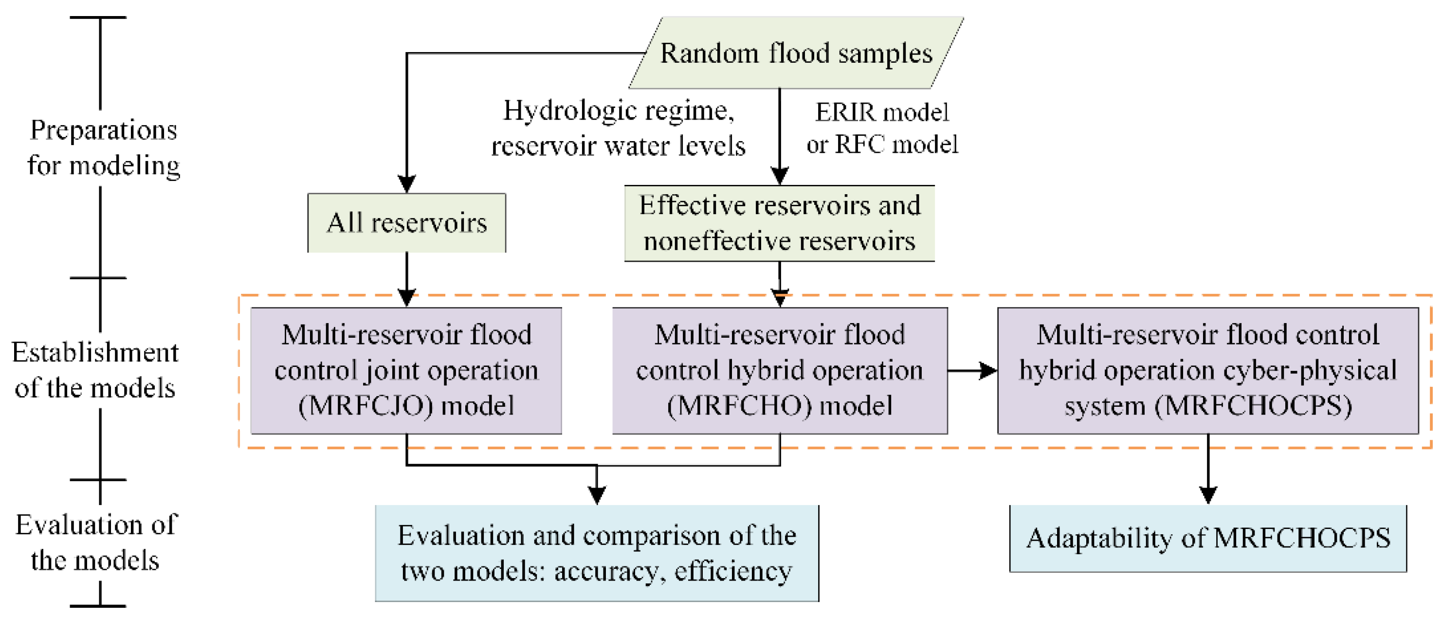
This section first generates random flood samples and establishes the MRFCHO model and the MRFCJO model. After that, the framework of MRFCHOCPS, including the MRFCHO model, is proposed by introducing the CPS theory. Finally, the performance of the MRFCHO model is compared with the MRFCJO model in terms of model accuracy and efficiency, and the adaptability of MRFCHOCPS is evaluated. Flowchart of the proposed dynamic self-adaptive modeling method is shown in Figure 1.
2.1. Generation of Flood Samples and Establishment of Operation Models
2.1.1. Generation of Random Flood Samples
The multi-reservoir system is composed of reservoir and the downstream flood control points. The flood control point is the protected object, e.g., a city. If there are two or more reservoirs upstream of a flood control point, this is the public flood control point. In large-scale basins, the spatial combination of floods is changeable. To verify whether the optimal operation model can adapt to the future real-time flood control operation, random flood samples need to be generated. In a large basin, floods have the characteristics of randomness in space and magnitude. Spatial randomness refers to the possibility that the inflow of a reservoir may occur in other reservoirs or flood control points. This paper adopts the spatial-magnitude double random flood samples generation method proposed by Li et al. [30] to generate representative regional random floods. Suppose the flood control system includes M reservoirs and N flood control points. Z random samples of reservoir inflows and lateral inflows are obtained, denoted as , , , , where is the random flood sample set, is the vth inflow of the ith reservoir, is the vth lateral inflow of the jth flood control point.
2.1.2. Establishment of the Operation Models
In real-time flood control operation, the effective reservoirs change dynamically. The main idea of the MRFCHO model is to divide the reservoirs into a subset of effective reservoirs and a subset of noneffective reservoirs. The effective reservoirs are operated jointly and the noneffective reservoirs are operated separately. The MRFCHO model is described as follows.
The separate optimal operation model is based on the principle of maximum flood peak reduction, and the objective function is as follows:
where, T is the duration of the operation period; is the reservoir outflow at time t.
The joint operation model aims at minimizing the peak discharge at the public flood control point, and the objective function is as follows:
where, is the response flow of the ith reservoir release at time t at the flood control point; is the response flow of lateral inflow between the ith reservoir and its private point at time t at the public flood control point; is the response flow of the lateral inflow between the effective reservoirs and the public flood control point at time t; is the total number of effective reservoirs.
The constraints are as follows.
- (a)
- Water balance equation:
- (b)
- Reservoir release capacity limits:
- (c)
- Reservoir water level limits:
- (d)
- End water level limits:
- (e)
- Reservoir release fluctuation limits:
The MRFCJO model carries out a joint operation to all reservoirs. The objective function is shown in Formula (8), and the constraints are the same as Formulas (3)–(7).
where, M is the number of reservoirs in the flood control system.
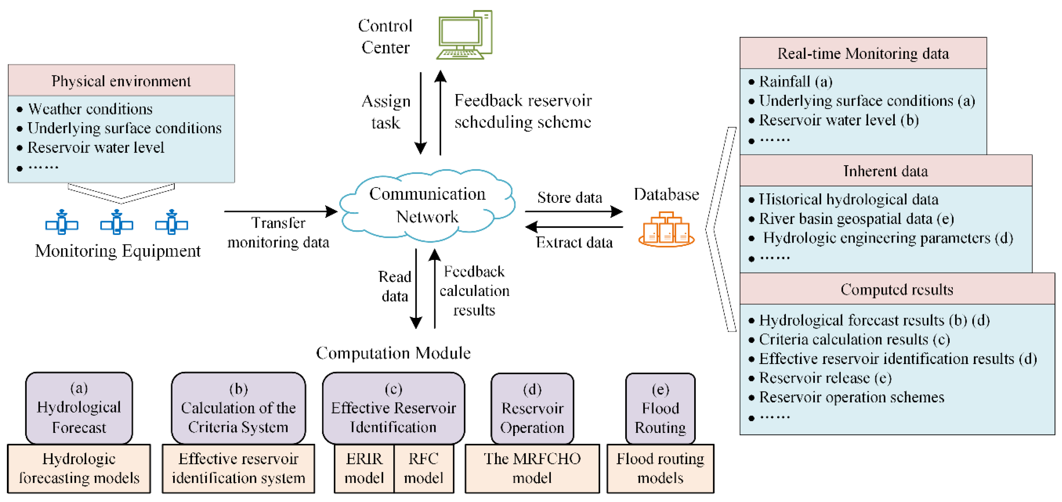
2.2. Establishment of the Multi-Reservoir Flood Control Hybrid Operation Cyber–Physical System
The framework of multi-reservoir flood control hybrid operation cyber–physical system (MRFCHOCPS) is proposed in this section by introducing the cyber–physical system (CPS) theory.
2.2.1. Framework Design of the MRFCHOCPS
CPS is an intelligent system that realizes real-time perception, dynamic coordination control, and information services of large-scale distributed heterogeneous systems through 3C technology, namely, communication, computation, and control [25]. In the CPS, sensors collect information about physical systems and transmit this information in real-time to computers and embedded systems for intelligent control. These network components use computational intelligence to process information and determine appropriate control settings for the physical components of the system.
MRFCHOCPS is specifically designed for real-time flood control operation of large-scale multi-reservoir systems, including five parts: real-time monitoring, control center, database, computation module, and communication network. In the computation module, the reservoir operation is realized by the MRFCHO model. The framework of the MRFCHOCPS is shown in Figure 2.
MRFCHOCPS adopts 3C technology to realize real-time monitoring, dynamic operation, and decision-making of the flood control of the multi-reservoir systems. Communication refers to the transmission of information among monitoring equipment, control center, database, and computation module. Computation refers to realizing the hydrological forecast, effective reservoir identification, real-time operation of the multi-reservoir system and flood evolution through computational models. Control refers to realizing information interaction and closely coordinated control of the monitoring equipment, database, and computing module through self-adaptive control technology.
2.2.2. Functions of Each Component of MRFCHOCPS
In MRFCHOCPS, the information can be interacted and coordinated to ensure real-time perception, reliable communication, high-speed calculation, and precise control of the system. The MRFCHOCPS has characteristics of perceptibility, heterogeneity, integration, autonomy, real-time capability, and reliability. The functions of components of MRFCHOCPS are as follows.
- (1)
- Monitoring equipment
The monitoring equipment monitors changes in the physical environment in real-time and transmits the information to the database for storage through the communication network, and then the information can be called by the calculation module. In this system, the physical environment is composed of many elements such as weather conditions, underlying surface environment, etc. The monitoring information is the input of the computation module and affects the calculation accuracy. Therefore, monitoring equipment is the basis to ensure the reliable operation of MRFCHOCPS.
- (2)
- Database
The database is used for the storage and management of data in MRFCHOCPS and provides support for the real-time intelligent operation system. The database contains three kinds of data: (a) inherent data, such as historical hydrological data, river basin geospatial data, and hydrologic engineering parameters; (b) monitoring data, such as real-time rain, flood, and reservoir water level; and (c) computed results, such as hydrological forecast results, criteria calculation results, effective reservoir identification results, reservoir operation schemes, and flood routing results. Various types of data in the database are organized and structured for information exchange and sharing among each part of the system.
- (3)
- Communication network
The communication network connects the main computing and physical components, mainly responsible for the data transmission and information interaction between various components of the system. Since reservoir flood control operation emphasizes real-time capability, the communication network needs to meet the accuracy and timeliness of communication.
- (4)
- Computation module
The computation module of MRFCHOCPS mainly includes the hydrological forecast model, criteria system calculation, effective reservoir identification model, reservoir operation model, and flood routing model. In practical applications, the most suitable model is selected in the forecasting model library for hydrological forecasting. The criteria for effective reservoir identification can be calculated according to the hydrological forecast results, and then the effective reservoirs can be identified [22]. Based on the subsets of effective reservoirs and noneffective reservoirs, the MRFCHO model is adopted to perform flood control hybrid operation of multi-reservoirs, and then the release of each reservoir is obtained. After that, the flow at each flood control point is obtained by calling the flood routing models. After the above calculation process, a real-time flood control operation is completed.
- (5)
- Control center
The control center of the system determines the control strategy, issues control instructions, and manages and controls the operation status of MRFCHOCPS, including centralized control and distributed control. Due to the continuous expansion of the flood control system, the MRFCHOCPS has a high complexity, and centralized control is difficult to meet the needs of the system for integrated control and management. Therefore, the distributed control platform performs better in a large-scale MRFCHOCPS.
2.3. Evaluation of the MRFCHO Model
The purpose of the establishment of the MRFCHO model in this paper is to improve the solution efficiency of the flood control operation model under the premise of ensuring the flood control effect. Therefore, the performance of the MRFCHO model in real-time flood control operation is evaluated in terms of model accuracy and solving efficiency.
2.3.1. Evaluation of the Model Accuracy
The RFC model is established according to L historical floods [23]. Calculate the criteria of each reservoir for Z floods in the sample set , and then identify the effective reservoirs of Z floods based on the RFC model. The MRFCJO model and the MRFCHO model are applied to the Z floods. The flood hydrograph obtained by the MRFCJO model is , and its peak discharge is ; the flood hydrograph obtained by the MRFCHO model is , and its peak discharge is . Then the relative error of the two models is defined as:
The relative error threshold to measure whether the two models are equivalent is denoted as . If , it is considered that the flood control effect of the MRFCHO model is much lower than that of the MRFCJO model, so the flood control effect of the two models is not equivalent. The effect of the MRFCHO model is measured by the equivalent qualified rate index, which is defined as follows:
where is the number of floods satisfied .
2.3.2. Evaluation of the Model Solving Efficiency
At present, the solution methods of the multi-reservoir optimal operation model include DP and its improved algorithms such as POA, DPSA, etc., as well as intelligent algorithms, such as GA, PSO, etc. Feng et al. [31] studied the time and space complexity of commonly used algorithms for optimal operation multi-reservoirs, and the results show that the space and time complexity of the algorithms will increase exponentially or manyfold with the increase of the number of reservoirs. This paper takes POA and GA as examples to evaluate the dimensionality reduction effect of the MRFCHO model.
Suppose there are M reservoirs for joint operation, T periods, and a total of I iterations. The initial time and the end time have one state variable. The state is fixed at time and time , and at time t, it is discretized into k states for optimization. The number of storage units of POA is and the number of regulating calculations is . The corresponding space complexity is and time complexity is .
Suppose there are M reservoirs for joint operation, T periods. The initial population size of GA is N, the selection probability is , the crossover probability is , and the mutation probability is . The maximum generation I is used as the termination condition. Each individual is regarded as an operation scheme, so the storage space of N individuals is . The number of individuals in one evolution is and the number of calculations is . The storage space of the I round of evolution remains unchanged, and there the total number of calculations is . , so that the maximum amount of calculation is . The corresponding space complexity is and time complexity is .
3. Case Study
3.1. Study Area
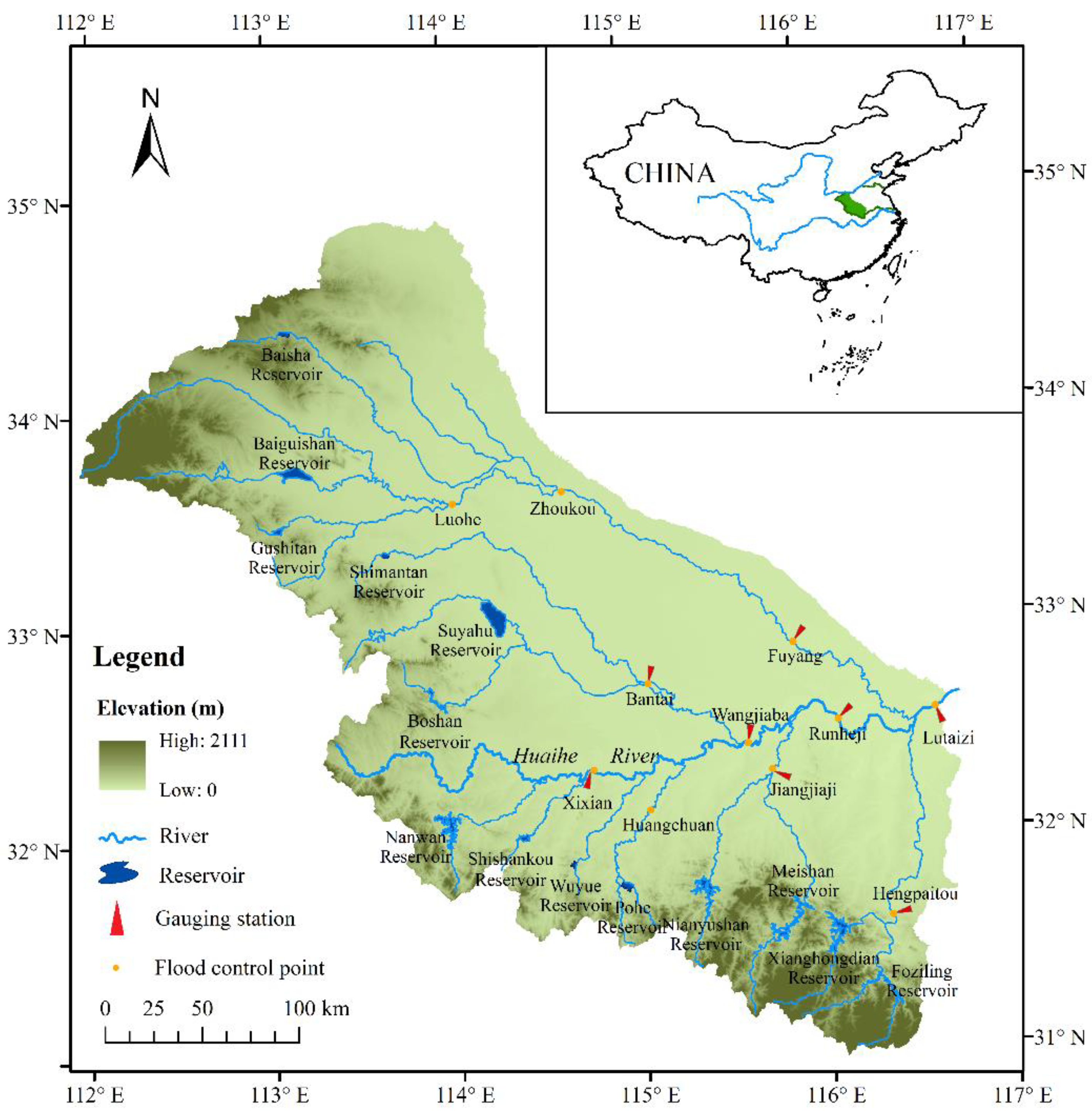
The Huaihe River basin is one of the most severely flooded areas in China. A large-scale flood control engineering system consisting of reservoirs and dikes has been built in this basin. This paper takes the flood control system upstream of the Lutaizi point of Huaihe River Basin as a case study, shown in Figure 3. There are 14 reservoirs and 11 flood control points in the flood control system, and Lutaizi point is a public flood control point of all reservoirs.
3.2. Data
The basin-wide flood which has a large-scale influence has been selected as a typical flood sample. The frequency of this kind of flood is very low. In the Huaihe River basin, since the 14 reservoirs have been put into operation, the basin-wide flood has occurred in 1983, 1991, 1996, 2003, 2005, and 2007. Considering factors such as spatial distribution of storm, flood magnitude, etc., 13 typical floods are selected, which could represent all possible scenarios of floods in the Huaihe River Basin. Each typical flood contains the inflows of 14 reservoirs and the lateral inflows upstream of the 11 flood control points. The duration of the flow data time series is 360 h. The lateral inflows are calculated by subtracting the outflows of the upstream reservoirs from the flow of the flood control point. Table 1 shows the characteristics of typical floods. Then, 1000 random flood samples are generated on the basis of the historical typical floods, denoted as , , , . The study of Li et al. [23] shows that the RFC model has high accuracy and stability in the identification of effective reservoirs. Therefore, the RFC model is established for the identification of effective reservoirs of these random flood samples.
4. Results and Discussion
4.1. Accuracy of the MRFCHO Model
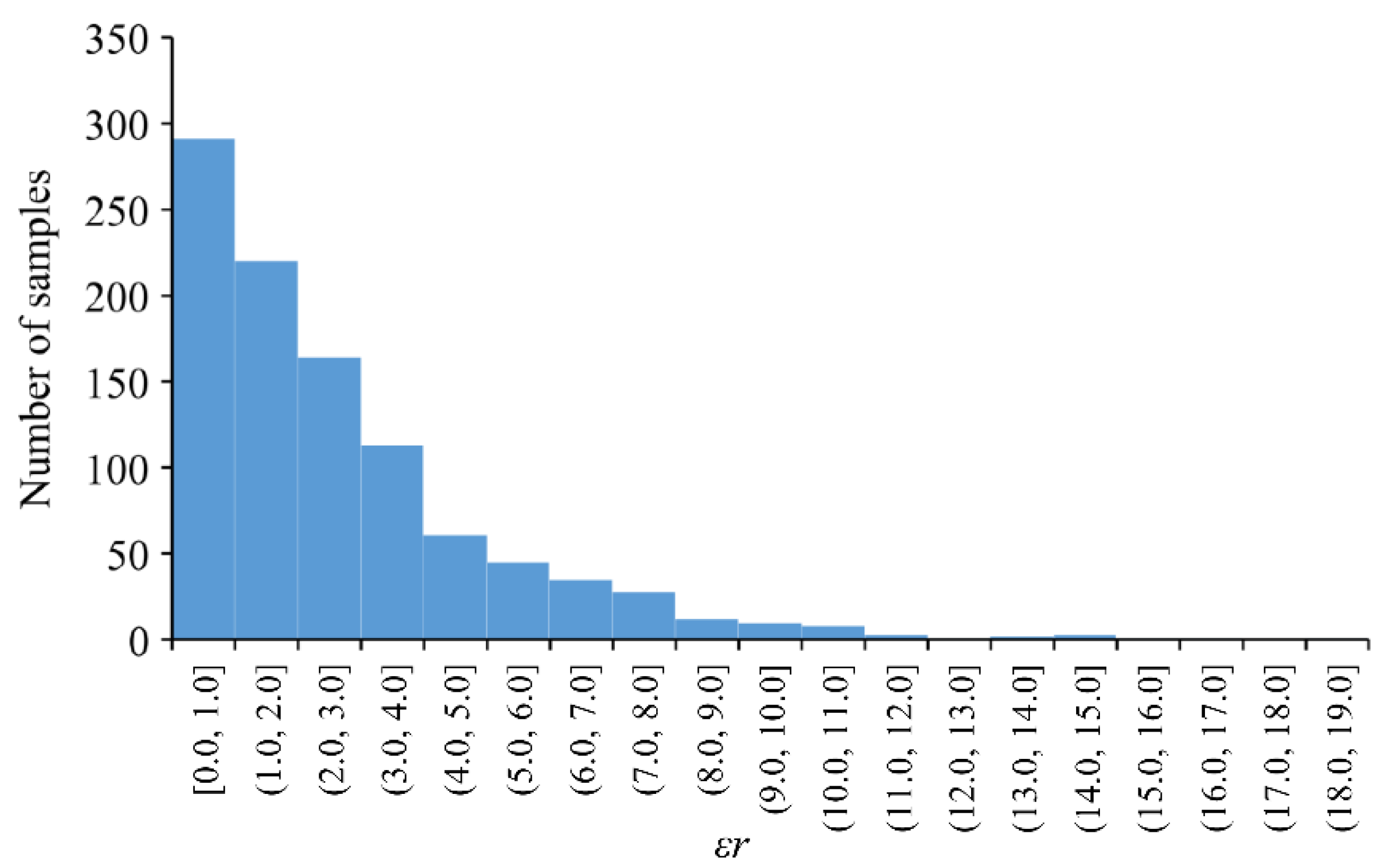
The effective reservoirs of the 1000 random samples are identified based on the RFC model. The initial water level and the end water level of each reservoir are set as the flood limited water level, and the highest water level is set as the design flood level. The flood control operation of the 1000 flood samples is carried out according to the MRFCJO model and the MRFCHO model, respectively. Then, the releases of 14 reservoirs and the flood hydrographs at 11 flood control points are obtained. Calculate the relative error of the flood peak discharges at the Lutaizi point obtained by the two models by Formula (9), and the statistical result of the relative error is shown in Figure 4.
According to China’s hydrological forecast error standard, the water level error should not exceed 20 mm. According to the rating curve of the Lutaizi point, the water level error can be less than 20 mm when the flow error does not exceed 5%. This paper measures the equivalence degree of the two models according to the requirements of runoff forecasting accuracy, so the relative error threshold of the Lutaizi point is taken as 5%. The equivalent qualified rate of the MRFCHO model is calculated by the Formula (10):
It can be seen from the above calculation results that the equivalent qualified rate of the MRFCHO model is 84.9%. The result reflects that in future floods, the probability of the relative error between the MRFCHO model and the MRFCJO model exceeding the threshold is 15.1%.
The equivalent qualified rate of the MRFCHO model in the flood of different magnitude is calculated, as shown in Table 2.
As can be seen from Table 2, with the decrease of flood magnitude, the equivalent qualified rate of the MRFCHO model generally presents a downward trend. When the peak discharge at the Lutaizi point QCm ≥ 7000 m3/s, the equivalent qualified rate is above 90%; when 4000 m3/s ≤ QCm < 7000 m3/s, the equivalent qualified rate is between 80% and 90%; when QCm < 4000 m3/s, the equivalent qualified rate is below 80%. The MRFCHO model is put forward to mitigate the dimension disaster problem of the multi-reservoir flood control operation for the basin-wide flood. It is not necessary to carry out the joint operation of multi-reservoirs for the flood of small magnitude. In the real-time flood control operation, it is better to apply the MRFCHO model to the flood with a large magnitude.
4.2. Solving Efficiency of the MRFCHO Model
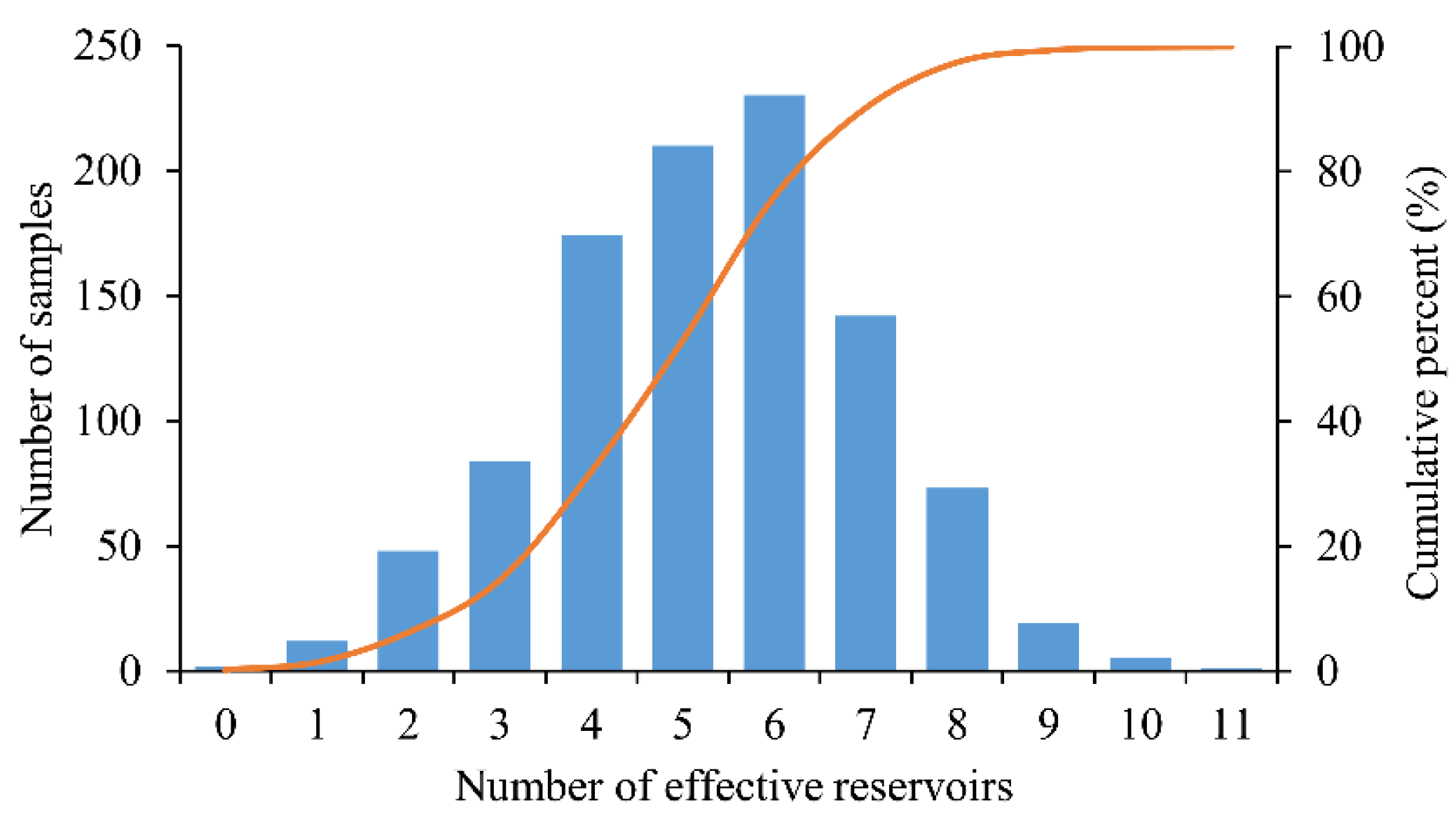
In order to analyze the solving efficiency of the MRFCHO model, the number of effective reservoirs in each flood sample is counted, as shown in Figure 5.
Figure 5 illustrates that the number of effective reservoirs is in the random flood samples less than 11, generally 4–7. The probability that the number of effective reservoirs accounts for less than 50% of all reservoirs is 90.2%. In addition, the probability of six effective reservoirs is the highest, which is 23%. Taking six effective reservoirs as an example, the complexity of POA and GA are shown in Table 3.
Table 3 illustrates that if POA is used, the space and time complexity of the MRFCHO model reduces exponentially compared with the MRFCJO model; and the complexity reduces manyfold if GA is used. Therefore, the MRFCHO model can significantly improve the solution efficiency, and this model is suitable for the real-time flood control operation of large-scale flood control systems.
4.3. Adaptability of MRFCHOCPS
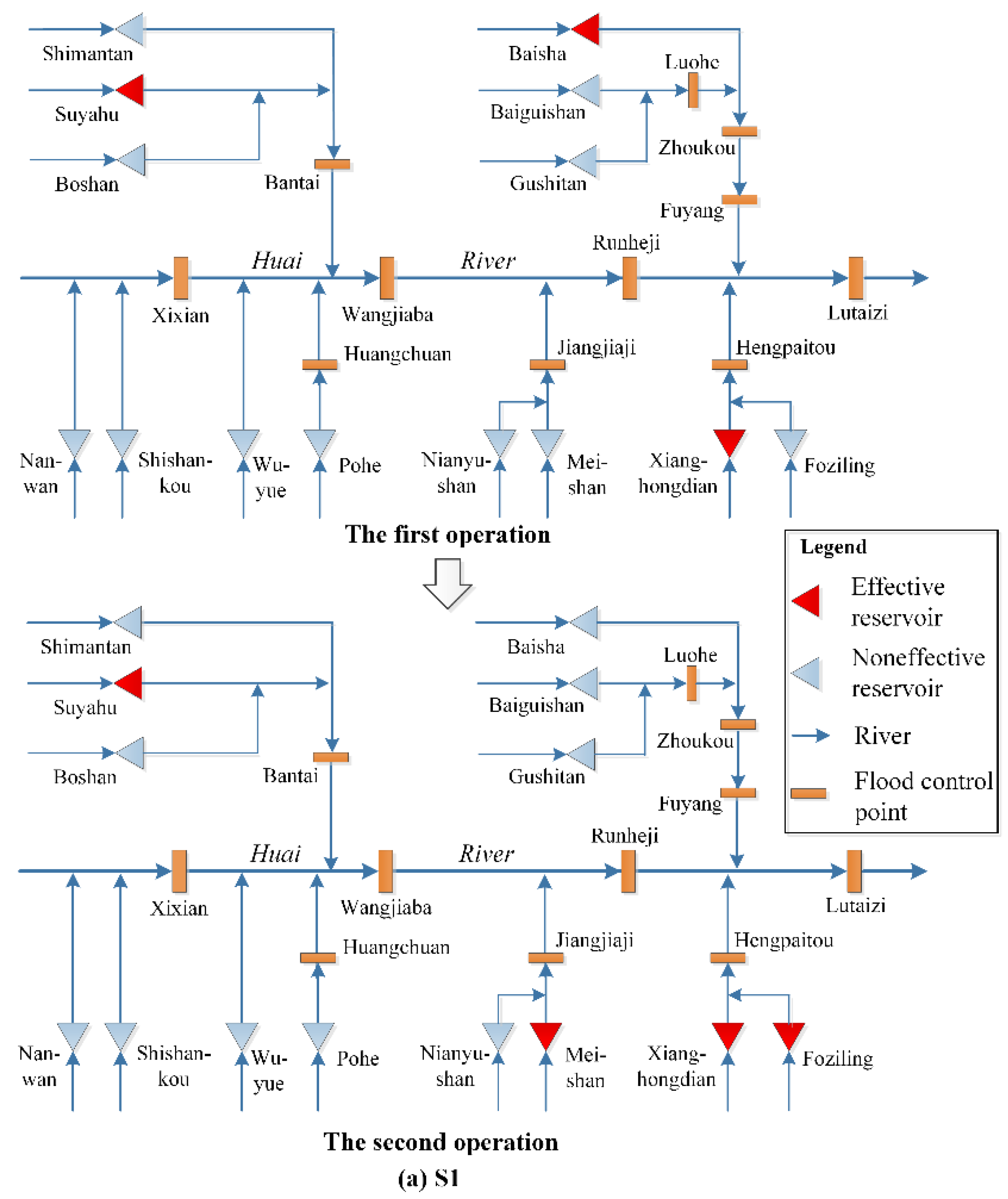
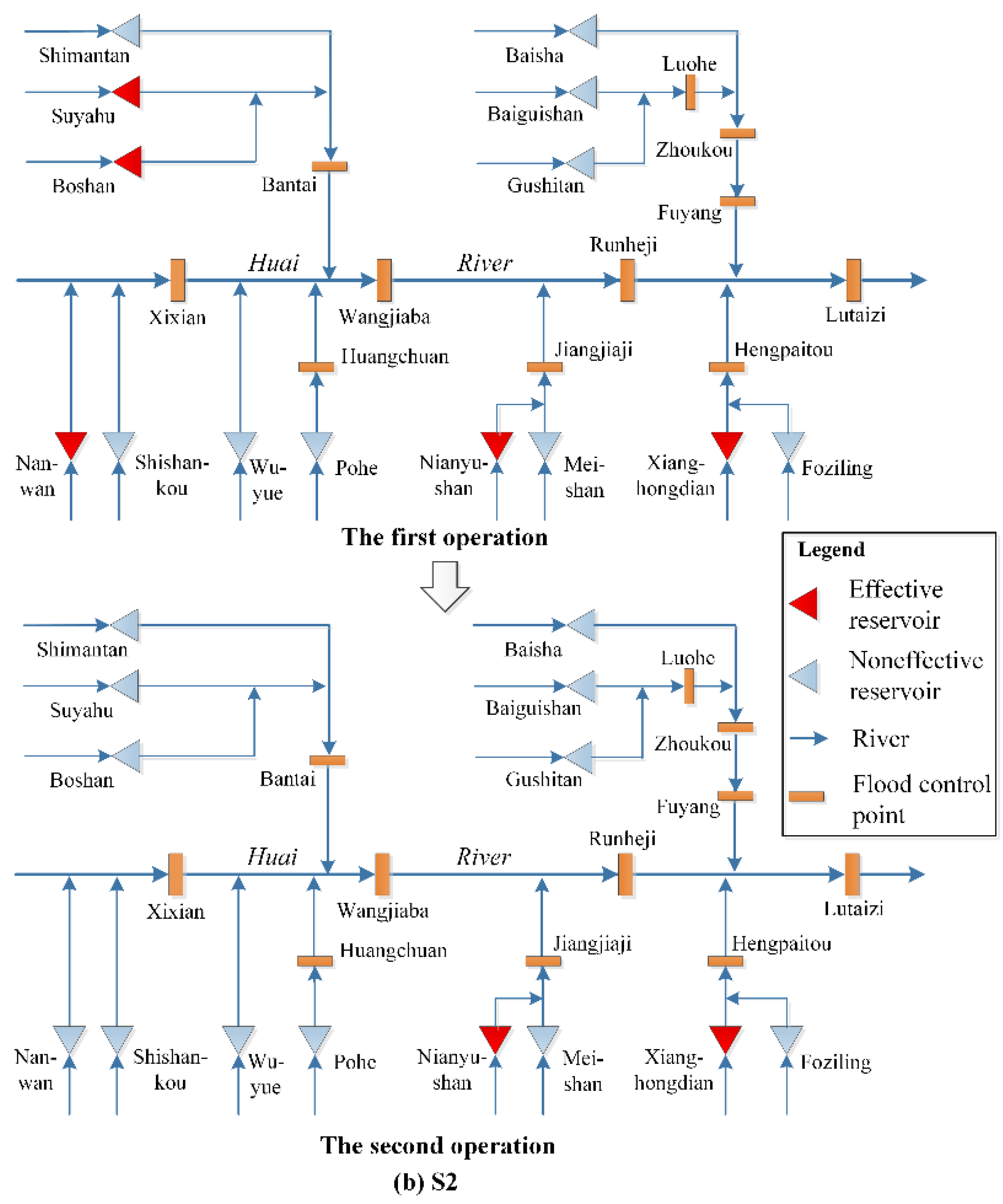
Two random flood samples are selected to assess the adaptability of MRFCHOCPS. Flood sample 1 and sample 2 are denoted as S1 and S2, respectively. In these two floods, implementing two operations at t = 0 and t = 120, and operation horizons are 240 h. Effective reservoirs of S1 and S2 are shown in Figure 6a,b.
In the first operation of S1, the effective reservoirs are Suyahu, Baiguishan, and Xianghongdian. The flood control situation keeps changing over time, and in the second operation of S1, the effective reservoirs are Suyahu, Meishan, Foziling, and Xianghongdian. In the first operation of S2, the effective reservoirs are Boshan, Suyahu, Nanwan, Nianyushan, and Xianghongdian. With the change of flood control situation, there are only two effective reservoirs in the second operation of S2, namely, Nianyushan and Xianghongdian.
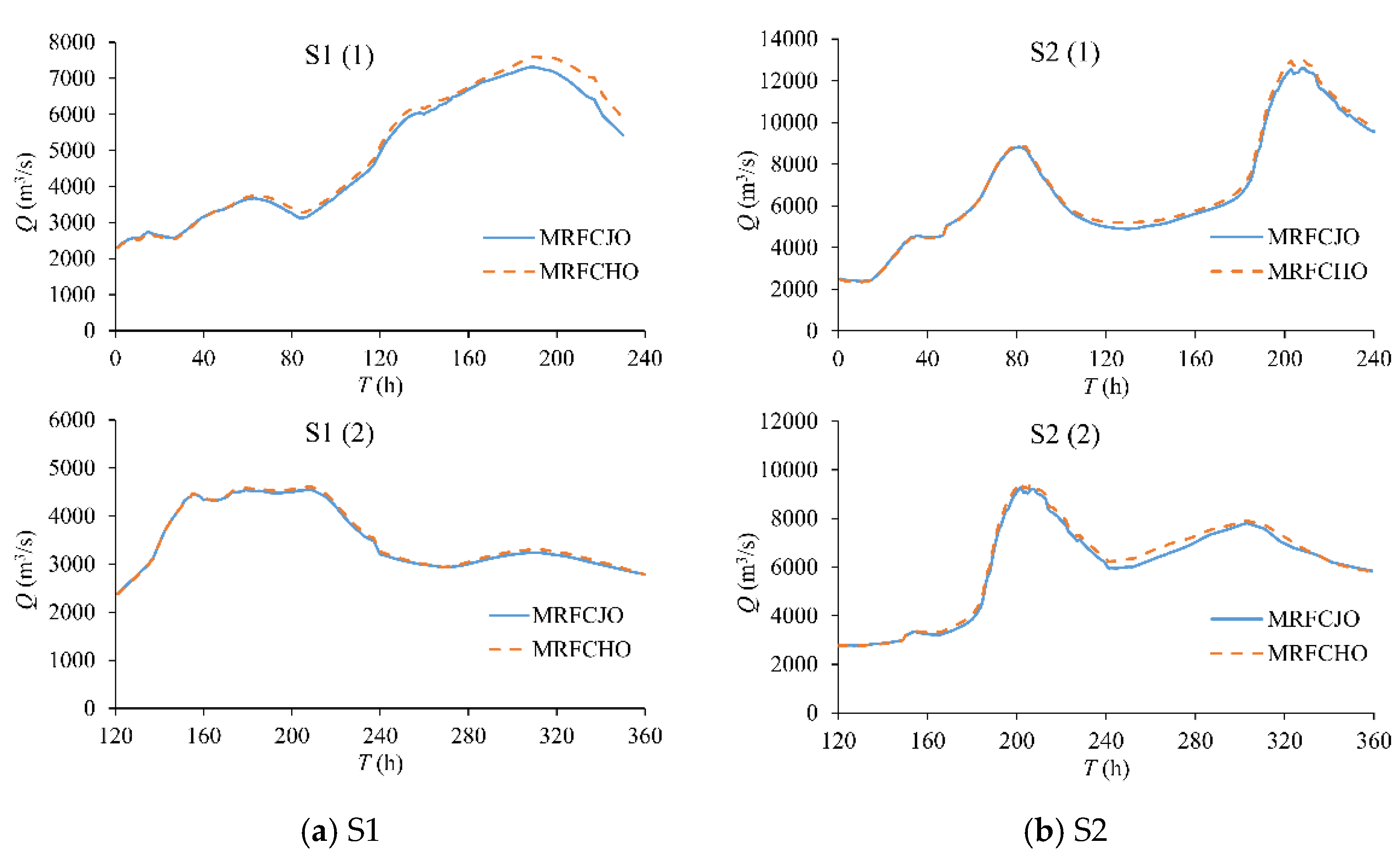
The flood hydrographs at the Lutaizi point of the two operations obtained by the MRFCJO model and the MRFCHO model of S1 are shown in Figure 7a. The flood hydrographs at the Lutaizi point of the two operations obtained by the MRFCJO model and the MRFCHO model of S2 are shown in Figure 7b. The relative errors (εr) of the peak discharge at the Lutaizi point obtained by the MRFCJO model and the MRFCHO model are shown in Table 4.
Table 4 shows that in flood S1, the relative error of the MRFCJO and MRFCHO model is 3.69% for the first operation and 1.54% for the second operation. In flood S2, the relative error is 3.17% for the first operation and 2.27% for the second operation. The MRFCHO model has the equivalent flood control effect to the MRFCJO model because the relative errors are not over the threshold of 5%.
The results illustrate that in real-time flood control operation, the effective reservoir identification sub-module in MRFCHOCPS can identify effective reservoirs according to the information of rain, flood, and reservoir conditions. Then, the MRFCHO model can be established adaptively based on the effective reservoirs and noneffective reservoirs. The MRFCHO model performs well in real-time flood control operations because it has approximately the same flood control effect as the MRFCJO model. Therefore, MRFCHOCPS has better adaptability in real-time dynamic modeling and operation of large-scale multi-reservoir systems to different floods.
5. Conclusions
In the real-time flood control operation of a large multi-reservoir system, not all reservoirs are effective for flood control, and the traditional flood control method is difficult to realize the adaptive combination of effective reservoirs. In this paper, the MRFCHOCPS framework is proposed, which adaptively combines effective reservoirs according to the spatiotemporal variation of flood control situations, establishes a dynamic model and realizes intelligent operation. First, a random flood sample set considering the randomness of both space and magnitude is generated and a MRFCHO model is established. Then, the CPS theory is introduced to put forward the MRFCHOCPS framework. Finally, the accuracy and solving efficiency of the MRFCHO model, as well as the adaptability of the MRFCHOCPS, are evaluated. A case study of the flood control system in upstream of Lutaizi point in the Huaihe River Basin shows that:
- (1)
- Among 1000 random flood samples, the equivalent qualified rate of the MRFCHO model is 84.9%. It shows that in the future real-time flood control operation, it is highly reliable to establish the MRFCHO model for flood control operation on the basis of identifying effective reservoirs.
- (2)
- The operation results of floods with different magnitudes show that the equivalent qualified rate decreases with the decrease of flood magnitude. When the peak discharge of the Lutaizi point is more than 7000 m3/s, the equivalent qualified rate is more than 90%. The MRFCHO model is more suitable for basin-wide floods.
- (3)
- In random flood samples, the number of effective reservoirs is generally 4–7, and the maximum number is not more than 11. Compared with the MRFCJO model, the space and time complexity of the MRFCHO model is reduced drastically.
- (4)
- The solving efficiency of the MRFCHO model is significantly improved compared with that of the MRFCJO model under the premise of ensuring the flood control effect. The MRFCHO model provides a reliable method for the real-time operation of basin-wide floods.
- (5)
- MRFCHOCPS has better adaptability in the real-time operation of large-scale multi-reservoir systems because it can realize the intelligent identification of effective reservoirs and dynamical modeling according to the rain and flood information.
Although this paper verifies the accuracy and efficiency of the MRFCHO model and the adaptability of MRFCHOCPS, there are many uncertainties such as flood forecast errors in real-time operation. The performance of the MRFCHO model under uncertain conditions needs further exploration.
Author Contributions
Methodology, J.L. and P.-a.Z.; software, J.L. and Y.W.; formal analysis, Y.L. and J.Z.; writing—original draft preparation, J.L.; writing—review and editing, M.Y. and W.L.; funding acquisition, J.L., P.-a.Z. and Y.W. All authors have read and agreed to the published version of the manuscript.
Funding
This research was funded by the National Key R&D Program of China, grant number 2021YFC3200404; National Natural Science Foundation of China, grant numbers 52079037 and 42041004; Science and Technology Development Foundation of Yellow River Institute of Hydraulic Research, grant number HKF202201; China Postdoctoral Science Foundation Funded Project, grant number 2021M702313.
Data Availability Statement
Data available on request due to restrictions, e.g., privacy or ethical.
Conflicts of Interest
The authors declare no conflict of interest.
References
- Wang, F.; Valeriano, O.C.S.; Sun, X. Near Real-Time Optimization of Multi-Reservoir during Flood Season in the Fengman Basin of China. Water Resour. Manag. 2013, 27, 4315–4335. [Google Scholar] [CrossRef]
- Donyaii, A.; Sarraf, A.; Ahmadi, H. Application of a New Approach in Optimizing the Operation of the Multi-Objective Reservoir. J. Hydraul. Struct. 2020, 6, 1–20. [Google Scholar]
- Yu, Y.; Zhao, R.; Zhang, J.; Yang, D.; Zhou, T. Multi-objective game theory optimization for balancing economic, social and ecological benefits in the Three Gorges Reservoir operation. Environ. Res. Lett. 2021, 16, 85007. [Google Scholar] [CrossRef]
- Avesani, D.; Zanfei, A.; Di Marco, N.; Galletti, A.; Ravazzolo, F.; Righetti, M.; Majone, B. Short-term hydropower optimization driven by innovative time-adapting econometric model. Appl. Energy 2022, 310, 118510. [Google Scholar] [CrossRef]
- De Ladurantaye, D.; Gendreau, M.; Potvin, J. Optimizing profits from hydroelectricity production. Comput. Oper. Res. 2009, 36, 499–529. [Google Scholar] [CrossRef] [Green Version]
- Ficchì, A.; Raso, L.; Dorchies, D.; Pianosi, F.; Malaterre, P.O.; Van Overloop, P.J.; Jay-Allemand, M. Optimal Operation of the Multireservoir System in the Seine River Basin Using Deterministic and Ensemble Forecasts. J. Water Res. Plan. Manag. 2016, 142, 5015005. [Google Scholar] [CrossRef] [Green Version]
- Zhu, F.; Zhong, P.; Xu, B.; Chen, J.; Sun, Y.; Liu, W.; Li, T. Stochastic multi-criteria decision making based on stepwise weight information for real-time reservoir operation. J. Clean. Prod. 2020, 257, 120554. [Google Scholar] [CrossRef]
- Opan, M. Irrigation-energy management using a DPSA-based optimization model in the Ceyhan Basin of Turkey. J. Hydrol. 2010, 385, 353–360. [Google Scholar] [CrossRef]
- Cheng, C.; Wu, H.; Wu, X.; Shen, J.; Wang, J. Power Generation Scheduling for Integrated Large and Small Hydropower Plant Systems in Southwest China. J. Water Res. Plan. Manag. 2017, 143, 4017021–4017027. [Google Scholar] [CrossRef]
- Zhang, X.; Yu, X.; Qin, H. Optimal operation of multi-reservoir hydropower systems using enhanced comprehensive learning particle swarm optimization. J. Hydro-Environ. Res. 2016, 10, 50–63. [Google Scholar] [CrossRef]
- Ladanu, A.A.; Akanmu, S.; Adeyemo, J. Enhancing Artificial Neural Network with Multi-Objective Evolutionary Algorithm for Optimizing Real Time Reservoir Operations: A Review. Am. J. Water Resour. 2020, 8, 118–127. [Google Scholar]
- Chen, H.; Wang, W.; Chen, X.; Qiu, L. Multi-objective reservoir operation using particle swarm optimization with adaptive random inertia weights. Water Sci. Eng. 2020, 13, 136–144. [Google Scholar] [CrossRef]
- Wang, W.; Jia, B.; Simonovic, S.P.; Wu, S.; Fan, Z.; Ren, L. Comparison of Representative Heuristic Algorithms for Multi-Objective Reservoir Optimal Operation. Water Resour. Manag. 2021, 35, 2741–2762. [Google Scholar] [CrossRef]
- Avesani, D.; Galletti, A.; Piccolroaz, S.; Bellin, A.; Majone, B. A dual-layer MPI continuous large-scale hydrological model including Human Systems. Environ. Modell. Softw. 2021, 139, 105003. [Google Scholar] [CrossRef]
- Yang, S.; Yang, D.; Chen, J.; Zhao, B. Real-time reservoir operation using recurrent neural networks and inflow forecast from a distributed hydrological model. J. Hydrol. 2019, 579, 124229. [Google Scholar] [CrossRef]
- Wei, C.; Hsu, N. Derived operating rules for a reservoir operation system: Comparison of decision trees, neural decision trees and fuzzy decision trees. Water Resour. Res. 2008, 44, W02428. [Google Scholar] [CrossRef]
- Liu, Y.; Qin, H.; Zhang, Z.; Yao, L.; Wang, Y.; Li, J.; Liu, G.; Zhou, J. Deriving reservoir operation rule based on Bayesian deep learning method considering multiple uncertainties. J. Hydrol. 2019, 579, 124207. [Google Scholar] [CrossRef]
- Ahmadi, M.; Bozorg Haddad, O.; Mariño, M.A. Extraction of Flexible Multi-Objective Real-Time Reservoir Operation Rules. Water Resour. Manag. 2014, 28, 131–147. [Google Scholar] [CrossRef]
- Levy, J.K. Multiple criteria decision making and decision support systems for flood risk management. Stoch. Environ. Res. Risk Assess. 2005, 19, 438–447. [Google Scholar] [CrossRef]
- Qi, H.; Altinakar, M.S. A GIS-based decision support system for integrated flood management under uncertainty with two dimensional numerical simulations. Environ. Modell. Softw. 2011, 26, 817–821. [Google Scholar] [CrossRef]
- Che, D.; Mays, L.W. Application of an Optimization/Simulation Model for Real-Time Flood-Control Operation of River-Reservoirs Systems. Water Resour. Manag. 2017, 31, 2285–2297. [Google Scholar] [CrossRef]
- Li, J.; Zhong, P.A.; Yang, M.; Zhu, F.; Chen, J.; Xu, B.; Liu, W. Dynamic and intelligent modeling methods for joint operation of a flood control system. J. Water Res. Plan. Manag. 2019, 145, 0401904410. [Google Scholar] [CrossRef]
- Li, J.; Zhong, P.; Yang, M.; Zhu, F.; Chen, J.; Liu, W.; Xu, S. Intelligent identification of effective reservoirs based on the random forest classification model. J. Hydrol. 2020, 591, 125324. [Google Scholar] [CrossRef]
- Derler, P.; Lee, E.A.; Vincentelli, A.S. Modeling cyber-physical systems. Proc. IEEE 2012, 100, 13–28. [Google Scholar] [CrossRef]
- Kuang, Z.J.; Hu, L.; Zhang, C. Characteristic analyzation of cyber physical systems. Appl. Mech. Mater. 2014, 484–485, 427–430. [Google Scholar] [CrossRef]
- Peng, Y.; Jolfaei, A.; Yu, K. A Novel Real-Time Deterministic Scheduling Mechanism in Industrial Cyber-Physical Systems for Energy Internet. IEEE T. Ind. Inform. 2022, 18, 5670–5680. [Google Scholar] [CrossRef]
- Mohanty, S.P. Advances in transportation cyber-physical system (T-CPS). IEEE Consum. Electron. Mag. 2020, 9, 4–6. [Google Scholar] [CrossRef]
- Wang, Z.; Song, H.; Watkins, D.W.; Ong, K.G.; Xue, P.; Yang, Q.; Shi, X. Cyber-physical systems for water sustainability: Challenges and opportunities. IEEE Commun. Mag. 2015, 53, 216–222. [Google Scholar] [CrossRef] [Green Version]
- Taormina, R.; Galelli, S.; Tippenhauer, N.O.; Salomons, E.; Ostfeld, A. Characterizing cyber-physical attacks on water distribution systems. J. Water Res. Plan. Manag. 2017, 143, 040170095. [Google Scholar] [CrossRef]
- Li, J.; Zhong, P.; Wang, Y.; Yang, M.; Fu, J.; Liu, W.; Xu, B. Risk analysis for the multi-reservoir flood control operation considering model structure and hydrological uncertainties. J. Hydrol. 2022, 612, 128263. [Google Scholar] [CrossRef]
- Feng, Z.K.; Niu, W.J.; Cheng, C.T.; Shen, J.J.; Wu, X.Y. Study on dimension reduction for optimal operation of large-scale hydropower system I: Theoretical analysis. J. Hydraul. Eng. 2017, 48, 146–156. (In Chinese) [Google Scholar]
Figure 1.
Flowchart of the proposed dynamic self-adaptive modeling method.

Figure 2.
The framework of MRFCHOCPS (Labeling of the data in the database corresponds to the models in the computation module, for example, the data labeled (a) are the input to model (a)).
Figure 2.
The framework of MRFCHOCPS (Labeling of the data in the database corresponds to the models in the computation module, for example, the data labeled (a) are the input to model (a)).

Figure 3.
The flood control system in upstream of Lutaizi point of Huaihe River basin.

Figure 4.
Relative error of the peak discharges obtained by the MRFCJO model and the MRFCHO model.

Figure 5.
The number of effective reservoirs in random flood samples.

Figure 6.
Effective reservoirs of (a) S1 and (b) S2.


Figure 7.
Flood hydrographs of (a) S1 and (b) S2 at the Lutaizi point.


Table 1.
The characteristics of typical floods.
| Serial Number | Location of Rainstorm Center | Flood Magnitude |
|---|---|---|
| 1 | centralizing in the whole basin | medium |
| 2 | centralizing in the whole basin | medium |
| 3 | centralizing in the southeast | large |
| 4 | centralizing in the whole basin | large |
| 5 | centralizing in the southeast | large |
| 6 | centralizing in the southeast | medium |
| 7 | centralizing in the southeast | small |
| 8 | centralizing in the southeast | small |
| 9 | centralizing in the upstream of the main stream | medium |
| 10 | centralizing in the southeast | small |
| 11 | centralizing in the whole basin | medium |
| 12 | centralizing in the upstream of the main stream | small |
| 13 | centralizing in the whole basin→centralizing in the southeast | large |
Table 2.
Equivalent Qualified rate in Flood of Different Magnitude.
| Peak Discharge at the Lutaizi Point (m3/s) | Number of Samples | Number of Qualified Samples | Equivalent Qualified Rate (%) | Non-Qualified Rate (%) |
|---|---|---|---|---|
| QCm ≥ 10,000 | 50 | 50 | 100 | 0 |
| 9000 ≤ QCm < 10,000 | 47 | 45 | 95.74 | 4.26 |
| 8000 ≤ QCm < 9000 | 65 | 63 | 96.92 | 3.08 |
| 7000 ≤ QCm < 8000 | 120 | 109 | 90.83 | 9.17 |
| 6000 ≤ QCm < 7000 | 172 | 149 | 86.63 | 13.37 |
| 5000 ≤ QCm < 6000 | 216 | 183 | 84.72 | 15.28 |
| 4000 ≤ QCm < 5000 | 185 | 153 | 82.70 | 17.30 |
| 3000 ≤ QCm < 4000 | 112 | 73 | 65.18 | 34.82 |
| QCm < 3000 | 33 | 24 | 72.73 | 27.27 |
Table 3.
The complexity of POA and GA.
| MRFCHO Model | MRFCJO Model | ||
|---|---|---|---|
| POA | space complexity | O(6k6) | O(14k14) |
| time complexity | O(6ITk6) | O(14ITk14) | |
| GA | space complexity | O(6NT) | O(14NT) |
| time complexity | O(6INT) | O(14INT) |
Table 4.
Relative errors (εr) of the peak discharge at the Lutaizi point.
| MRFCJO | MRFCHO | Relative Error (%) | ||
|---|---|---|---|---|
| S1 | (1) | 7320 | 7590 | 3.69 |
| (2) | 4540 | 4610 | 1.54 | |
| S2 | (1) | 12,600 | 13,000 | 3.17 |
| (2) | 9260 | 9470 | 2.27 |
Publisher’s Note: MDPI stays neutral with regard to jurisdictional claims in published maps and institutional affiliations. |
© 2022 by the authors. Licensee MDPI, Basel, Switzerland. This article is an open access article distributed under the terms and conditions of the Creative Commons Attribution (CC BY) license (https://creativecommons.org/licenses/by/4.0/).
Share and Cite
MDPI and ACS Style
Li, J.; Zhong, P.-a.; Wang, Y.; Liu, Y.; Zheng, J.; Yang, M.; Liu, W. Dynamic Self-Adaptive Modeling for Real-Time Flood Control Operation of Multi-Reservoir Systems. Water 2022, 14, 3740. https://doi.org/10.3390/w14223740
AMA Style
Li J, Zhong P-a, Wang Y, Liu Y, Zheng J, Yang M, Liu W. Dynamic Self-Adaptive Modeling for Real-Time Flood Control Operation of Multi-Reservoir Systems. Water. 2022; 14(22):3740. https://doi.org/10.3390/w14223740
Chicago/Turabian StyleLi, Jieyu, Ping-an Zhong, Yuanjian Wang, Yanhui Liu, Jiayun Zheng, Minzhi Yang, and Weifeng Liu. 2022. "Dynamic Self-Adaptive Modeling for Real-Time Flood Control Operation of Multi-Reservoir Systems" Water 14, no. 22: 3740. https://doi.org/10.3390/w14223740
Note that from the first issue of 2016, this journal uses article numbers instead of page numbers. See further details here.