

The Role of Runoff Attenuation Features (RAFs) in Natural Flood Management

1
School of Engineering, Newcastle University, Newcastle Upon Tyne NE1 7RU, UK
2
James Hutton Institute, Aberdeen AB15 8QH, UK
3
Agri-Food and Biosciences Institute, Belfast BT9 5PX, UK
*
Author to whom correspondence should be addressed.
Water 2022, 14(23), 3807; https://doi.org/10.3390/w14233807
Submission received: 30 September 2022
/
Revised: 16 November 2022
/
Accepted: 18 November 2022
/
Published: 23 November 2022
(This article belongs to the Special Issue Natural Flood Management as an Adaptive Pathway to Climate-Resilient Communities)
Abstract
:Natural Flood Management (NFM) and catchment-based solutions for flood risk management and environmental problems are wide-ranging and complex. Management of fluvial flood risk in the UK is undergoing a fundamental shift, with a change in emphasis from solely working with structural defences to considering catchment-based measures which attenuate flood runoff. At the heart of this change are NFM and nature-based solutions. One key type of intervention is the Runoff Attenuation Feature (RAF): a class of features that targets runoff flow pathways and creates new temporary flow storage (such as ponds and leaky barriers). However, there is currently a lack of evidence for the effectiveness of NFM and RAFs at larger catchment scales and for managing extreme flood events. Nevertheless, there is a strong evidence base to suggest that well-designed RAFs deliver a range of ecosystem services if installed in the correct location. This paper reviews and critiques the role of RAFs and NFM as an interventionist and holistic approach to lowering runoff rates. The link between RAF design types and their relationship to land use and scale is made. Recent novel innovations and attempts to scale up RAFs are discussed. The role of antecedent conditions, groundwater and the change in residence time of processes is highlighted. The uncertainty and complexity of proving NFM effectiveness underpin a view that new thinking in catchment flood management is needed. New research is required, and many questions are raised about RAFs and NFM. The direction of travel is that a positive and proactive NFM community can now embrace the problem. Proof that RAFs and NFM can address flood management is not likely to be resolved without a great deal of further research but confidence that RAFs do beneficial work is growing and an argument for greater amounts of runoff attenuation is made.
1. Introduction
Current and future flood risks are rising due to climate and land use change, with peak runoff flows estimated to increase at a rate of over 5% per decade and 10% of new homes being built in areas of significant flood risk [1,2,3]. Recent studies have highlighted how some 12,000 km2 of UK land is at risk of flooding and 5 million people are at risk [4,5,6]. Climate change and land use scenarios predict that flood risk will increase in frequency and magnitude [7]. As flood risk continues to grow, the reliance solely on traditional structural measures to manage floods is questioned [8,9]. Holistic catchment-based approaches may also be required, and this includes the adoption of non-structural methods [10]. This provides the backdrop to growing interest and investment in Natural Flood Management (NFM) alongside traditional flood defences [11]. NFM is defined as the alteration, restoration or use of landscape features to reduce flood risk [12]. NFM utilises soft engineering methods that seek to emulate natural processes and suggest nature-based solutions as a landscape design concept. Approaches to NFM include increased water retention, for example, using afforestation [13]; the creation of ‘natural’ wetlands and temporarily constructed ponds [14,15,16,17]; altering flow velocities through large woody debris (LWD) and wet woodlands [8]. A subset of these: temporary storage ponds and structures for backing up flow are often referred to as Runoff Attenuation Features (RAFs), a term first used by Wilkinson et al. [18]. This variety of measures is targeted at reducing flooding, however, most of them fulfill multiple objectives, for example, improved biodiversity and carbon sequestration. Enhanced water quality and drought resilience can be considered together in many cases. Managing water quantity and quality together requires the fundamental alteration of the catchment’s annual water balance [19].
Uptake of NFM measures by practitioners remains limited [20,21], partly because there is little evidence demonstrating their effectiveness in reducing flood hazard at scales greater than ~10 km2 [16,17,22]. While wide-ranging reviews of NFM show the positive impacts of NFM at the field scale, the evidence of changes downstream is still lacking [14,23]. However, the absence of evidence is not evidence of absence. For now, the weight of evidence is that flow can be slowed, and multiple objectives could be achieved at a local scale and for smaller return interval storms [24].
Despite the evidence gap, over 4000 NFM assets have been created in the UK with woody, leaky barriers making up 69% of all measures [25,26]. A review of ‘Future Flood Protection’ [6] committed the Environment Agency for England and Wales (EA) to catchment measures as part of future flood risk management schemes. The Scottish Environment Protection Agency (SEPA) NFM handbook [27] supports a similar approach. The Defra 25-year Environment Plan [2] also calls for NFM solutions, and the National Flood and Coastal Erosion Risk Management Strategy for England calls for the use of NFM techniques to improve the resilience of schemes with respect to future climate change scenarios [28]. The use of online and offline ponds has been encouraged, for example, ‘Working with Natural Processes’ (WWNP) [24]. This included a more ‘engineered’ approach to NFM where runoff flow pathways are changed, and new temporary storage is created.
Hydrological and hydraulic modelling can be used as evidence to investigate impacts [28,29]. The focus has been on land cover and land use management changes, with results from several studies suggesting that such interventions may be more effective at reducing flood risk at the smaller catchment scale [29,30]. However, reliable predictions of the impacts of NFM change on catchment scale flooding are hampered by quantifying predictive uncertainty and model validation [23,31,32,33]. On a fundamental scale, Beven [34] argues all model uncertainty must be considered. Model-based evidence underpins many NFM schemes, but without long-term observed flow hydrological measurement for model calibration, many schemes may not progress [35,36].
Many recent reports (many of which are not in peer-reviewed International Scientific Indexing journals literature) have also pressed for better holistic catchment management. Advancing from the WWNP [24] and SEPA NFM handbook [27], the United States Army Corps of Engineers is supporting a wide range of novel approaches to flood management with many case studies, which is entitled ‘Engineering with Nature’ [37]. The UK Natural Environmental Research Council has also funded and completed three years of study into NFM, with a mixture of innovations, data collection and modelling studies [38]. The outputs are both positive and negative, commenting on current NFM approaches and listing many questions about NFM in the future. However, good momentum in NFM research has now been established with new practitioners in academia and the wider industry. Most recently, the UK CIRIA [39] has authored the ‘NFM Guide’, again bringing together evidence and case studies for use by flood management industry practitioners. CIRIA’s manual reflects the state of the practice, without overselling NFM as a proven flood solution, and reviews the current status and the gaps in the evidence.
We argue that it is timely to review the role of RAFs in NFM and add to the evidence an updated summary of good practice, recent innovations and scaling-up issues, but most importantly make a call for new research questions to be addressed. In Lashford et al. [40] a wide range of sustainable catchment-wide flood management terminology and solutions being practised in the UK are discussed, and the broader term for RAFs of ‘runoff pathway management’ is used.
RAFs are soft-engineering interventions designed to reduce runoff rates by slowing flow velocities and creating temporary storage of water during periods of higher flow. Their use hinges on an engineered landscape interventionist approach principally for flood management [41,42], but additional benefits include the improvement of water quality through sediment and phosphorus stripping [43] and ecological enhancement [44]. They provide temporary storage of flood water, disconnecting and altering flow pathways throughout a catchment, and crucially can operate during hazardous high flows [16,18]. The term RAF includes features such as soil bunds that create temporary storage areas and ‘leaky dams’ or leaky barriers that temporarily reduce flow velocities and store flood flow. In general, RAFs mimic the function of traditional flood detention ponds and bunds to control flood high flow while offering additional benefits such as reducing diffuse pollution. Most are relatively small, fitting well into farmed landscapes without negatively impacting too much on farm production and revenues. In 2010, the use of RAFs for flood protection was pioneered in the Belford NFM study in the United Kingdom [18], and since then numerous case studies have developed and expanded RAF design and gathered evidence of their engineering and hydrological performance in space and time through detailed laboratory experiments, fieldwork and full-scale modelling. As RAFs are now well established in research papers, simulation models and government policy documents, it is timely that a critique is made of their design and operation in the landscape and of their contribution to NFM.
This paper investigates and critiques the potential to manage runoff using RAFs. The crucial role of RAF design and scale and the potential role they play in groundwater recharge are discussed. The role of RAFs in NFM is reviewed in particular with regard to scale. It is argued that, despite the uncertainty, the confidence gained from adding RAFs and NFM features to the landscape should not be lost. The ability to innovate and improve NFM should continue and the goal of using RAFs for multiple objectives for better environmental management should be emphasised. If the onus of proof is required a priori in a flooding remediation management plan, then can NFM ever be financially justified if compared with traditional methods relying on “hard” engineering? We pose the questions:
- Is there a middle way that uses NFM and traditional skills together?
- Is a broader environmental set of goals required to address sustainable landscapes?
We review a range of scenarios for various hillslope, channel and floodplain configurations in order to improve RAF design, examine the changes to the surface and subsurface flow pathways and evaluate the implications in space and time on RAF function. Example factors that are currently overlooked in NFM are highlighted, such as slowing and storing flow in subsurface pathways, disconnecting fast overland flow and when to engage floodplains and storage ponds. The key differences between online and offline RAFs are emphasised. The fundamental elements of RAF design function to maximise flood reduction and the role catchment-wide RAF networks play in NFM using a Catchment Systems Engineering approach [19] are discussed. The complementary role of wider NFM measures such as tree planting and soil improvement working in tandem with RAFs are discussed in brief.
All engineered structures that slow or store flow can be described as RAFs. However, the RAFs presented and discussed here are soft-engineered features such as temporary storage ponds, bunds, excavations, swales and leaky barriers. This paper discusses the role of such structures focusing on four specific classes of RAF: leaky barriers, online ponds (including within field overland flow interception bunds and within channel bunds), offline ponds and draw off structures. Recommendations on RAF design and placement are made based on experience and a series of key questions are posed, highlighting several areas where further research is needed. By showing how RAFs alter flow velocities and flow pathways and provide temporary flow storage, the likely impact on flooding can be evaluated.
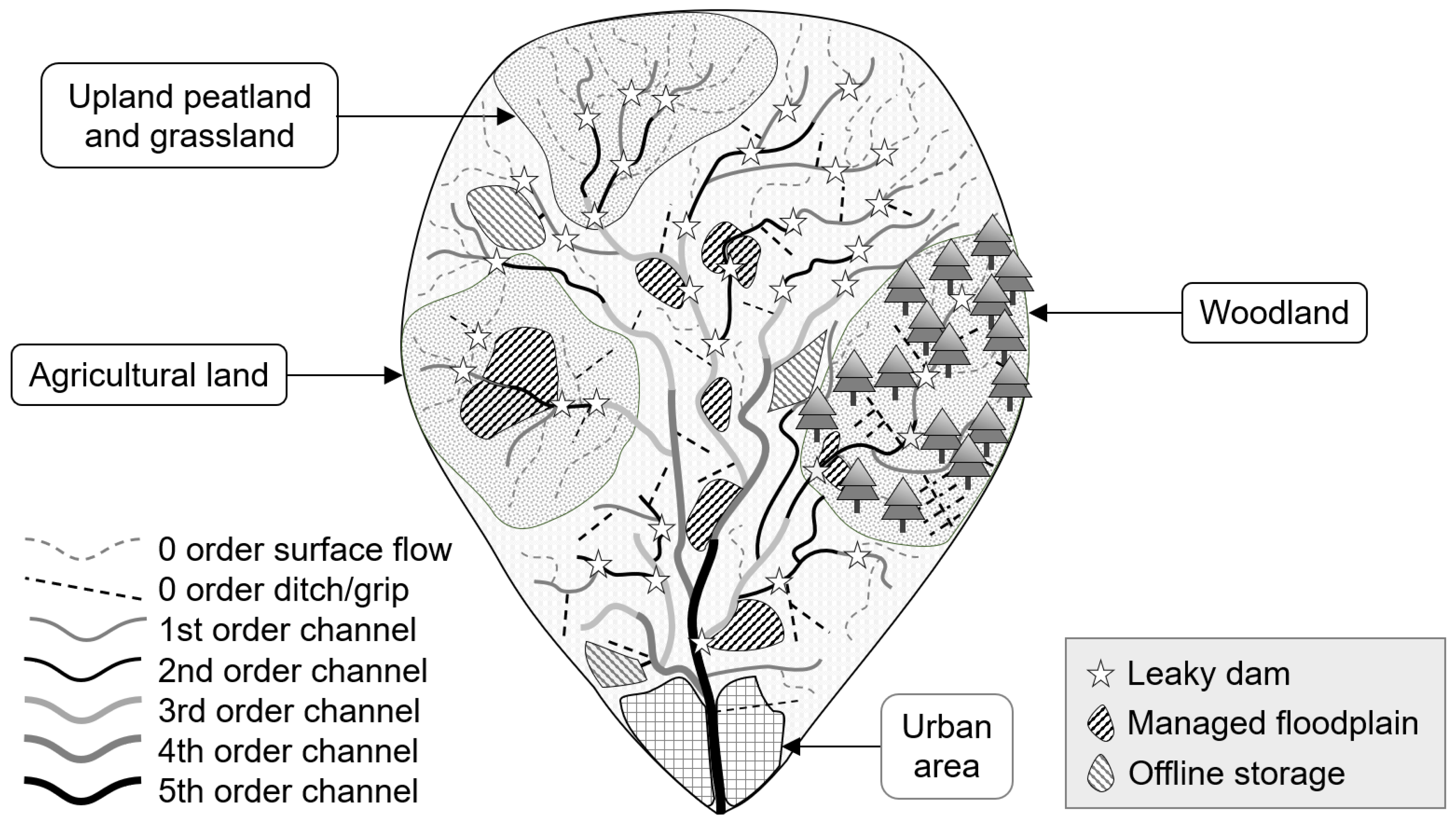
Hewett et al. [19] set out the Catchment Systems Engineering (CSE) approach, highlighting the need for RAFs to play a complementary role to other Nature Based Solutions (NBS) and NFM methods such as afforestation and peat restoration. RAFs need to be deployed throughout a catchment if a landscape scale shift in the water balance is to be achieved (Figure 1). The CSE approach recognises the need to alter RAF design as scale changes. For example, a feature that works well on overland flow in a field is very different from one required in a buffer strip or on a large floodplain. Equally, a RAF must operate and alter velocities and storage during large flood flows if flood peaks are to be significantly reduced. Therefore, structures often need to be significantly larger than many think initially, and dense networks of RAFs are needed for any impact to be apparent at the scale of even a small catchment. Engineering existing wetlands, ditches and buffers can increase flood attenuation capacity. Finally, RAFs should fit into both natural and farmed landscapes without causing great loss of land or food production and RAFs should not inundate land for long durations. In fact, carefully designed RAFs in the right location can encourage new drainage to remove flood flow that can also improve the quality of the farmed land.
2. RAF Types and Best Practice
The wider literature [19,41] covers many types of RAF, but here four main examples are discussed: leaky barrier (LB); online pond (overland flow interception bund and/or channel pond); offline pond and draw off structure.
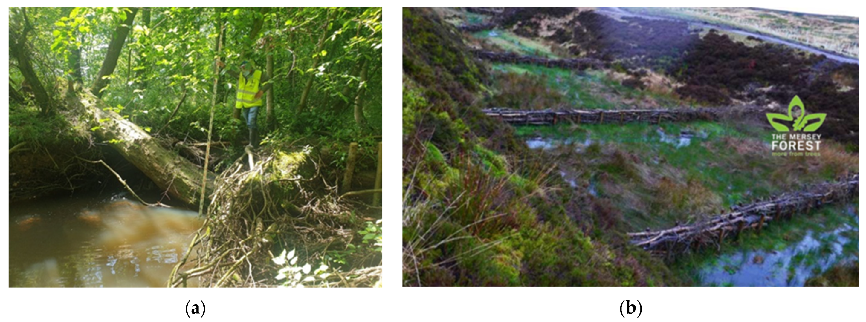
Leaky Barriers (LBs), also commonly described as large woody debris, are a measure being widely implemented in landscapes [38]. They target flow velocities and increase channel roughness. A well-designed leaky barrier will engage the floodplain to its maximum effect and/or feed other RAFs such as ponds, floodplains or natural wetlands.
Figure 2 highlights two well-constructed LBs: these are engineered to reduce flood flows, are quite high above the channel bed (to allow fish passage) and can withstand large flows before overtopping. An important recent innovation in RAF design is a shift to living barriers, with the aim of lengthening feature life and to integrate with any riparian woodland planting [45]. Two key aspects of the design are that the LBs can engage flow back onto the surrounding landscape or floodplain and can also play an important role in altering groundwater pathways, discussed later in this paper. The LB should force flow back into and onto the surrounding floodplain. If water backs up and overtops quickly then the effect in terms of reducing higher flows is diminished. Whilst the precise leakiness is difficult to determine a priori, it is suggested that large networks of barriers (for example having 105 Leaky Barriers in Wilde Brook, Shropshire UK [46]) should be created, as some RAFs will work better than others and they may function optimally at different flow rates. Therefore, the first question we pose is:
- What leakiness pattern is needed in RAFs designs? This is especially pertinent if the barrier is a natural wooden structure.
Whilst this issue is difficult to resolve, it is recommended that more is better, but it is essential to make sure that the engineered structures can operate at flood flow levels without being compromised. Installation experience and expertise are key to getting this right [24].
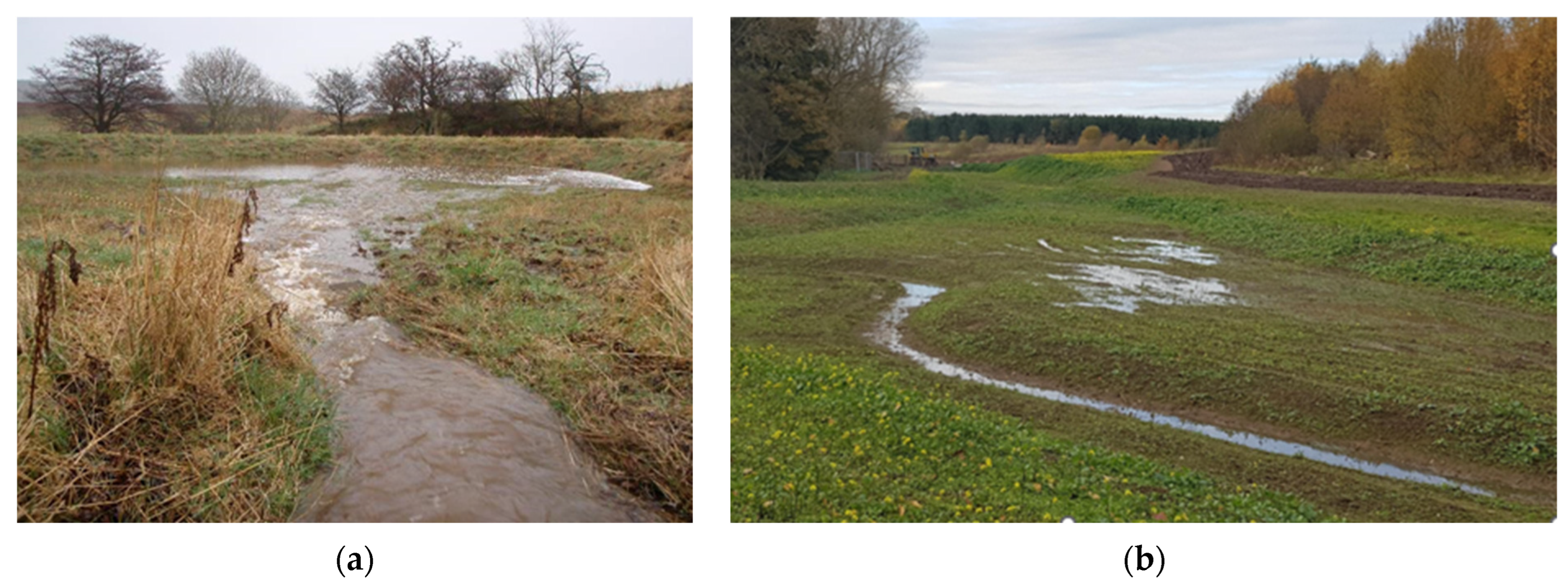
Online Ponds can be situated in fields to target temporary flow pathways or to target flow in ditches or small channels. Overland flow interception bunds and bunds on small channels are good options if circumstances allow. A keen eye, field surveys or a good pond location tool (using GIS analysis techniques) are now offered by many consultants and Non-Governmental Organisations (e.g., Rivers Trusts https://theriverstrust.org/ (accessed on 29 September 2022) and the UK River Restoration Centre, https://www.therrc.co.uk/ (accessed on 29 September 2022)). It is important that site visits and stakeholder meetings should be carried out for all RAF design schemes.
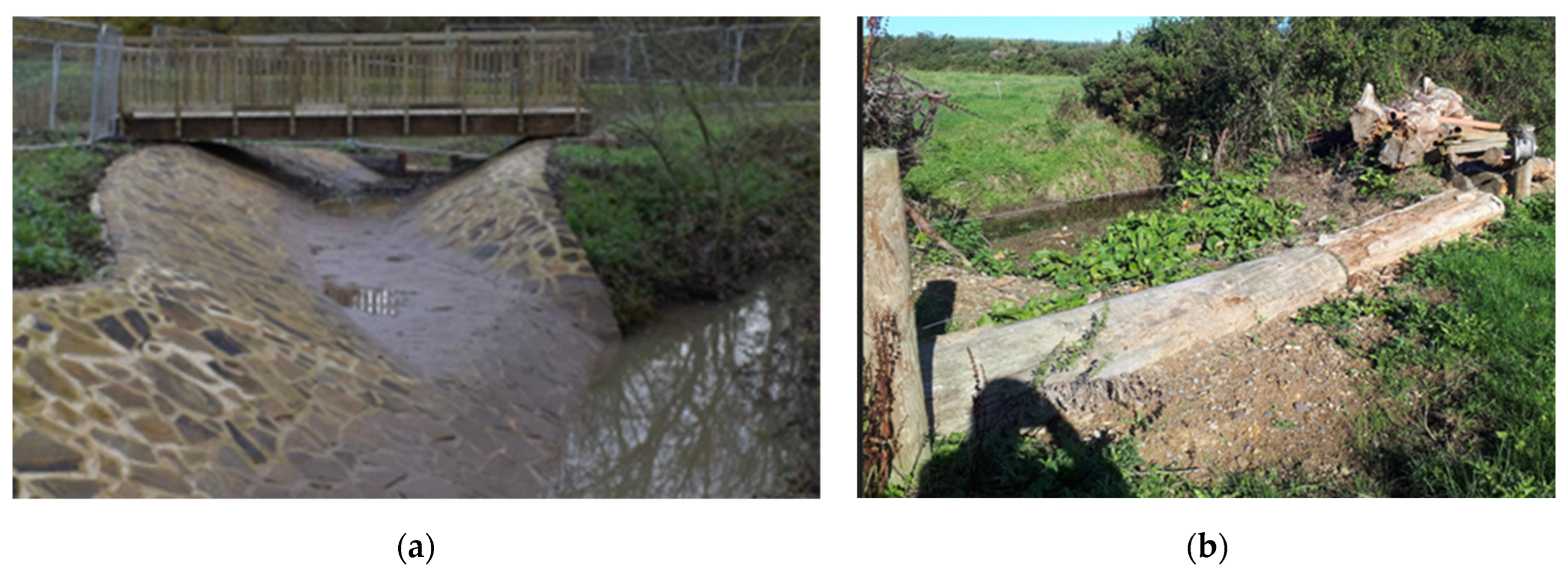
Figure 3 shows two examples of online ponds in Northumberland, UK. On the left-hand side (a) is Belford Burn, showing a within-field bund targeting an overland flow pathway. The barrier was also built as a farm track. The photograph on the right depicts a channel pond at Slatey Sike, near Haltwhistle. Both bunds have a large diameter discharge pipe to let a significant volume of flow pass through and drain the feature quickly after the storm passes. On the right side (b), four ponds were created in sequence, approximately 40 m wide and 1 m deep at the highest point. The organic soil was carefully excavated and reused to make the barriers. The bund width is 10 m wide and the original grass was replaced on the bund immediately after construction. A simple pond design tool can be used with a design storm to estimate the correct pipe diameter.
Online ponds features can be built at any scale, but they are best deployed either within a field; targeting overland flow pathways or in a low-order stream as the degree of construction required needs to be proportional to the impact they will have. The use of local materials and the need for a trained and skilled digger (excavator) driver are required. Ponds should ideally be largely empty after a few hours from the beginning of the storm, and we recommend a drainage time of the order of 12 h. Generally, these features range from 100 to 10,000 m3. Therefore, a key question is [41]:
- How should online ponds be managed and maintained, especially as they start to silt up and become overgrown?
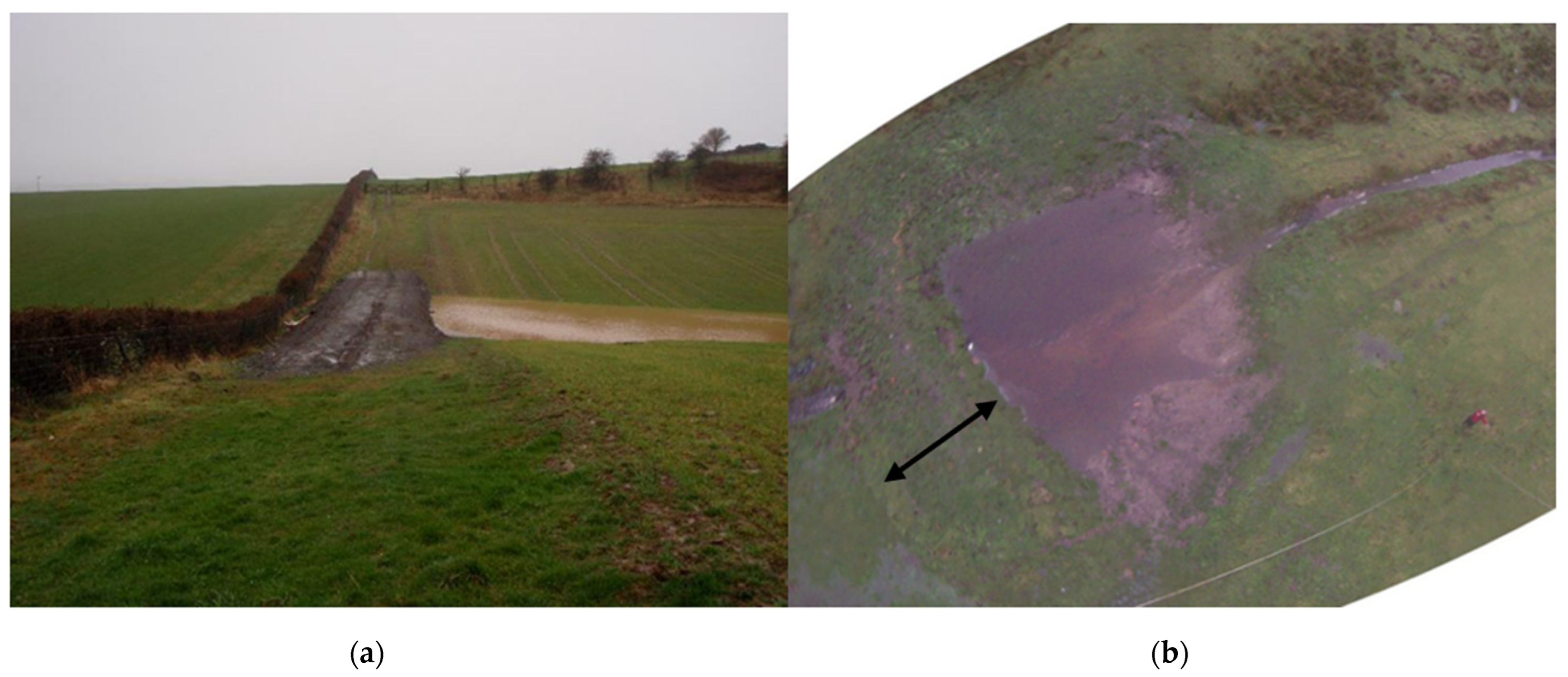
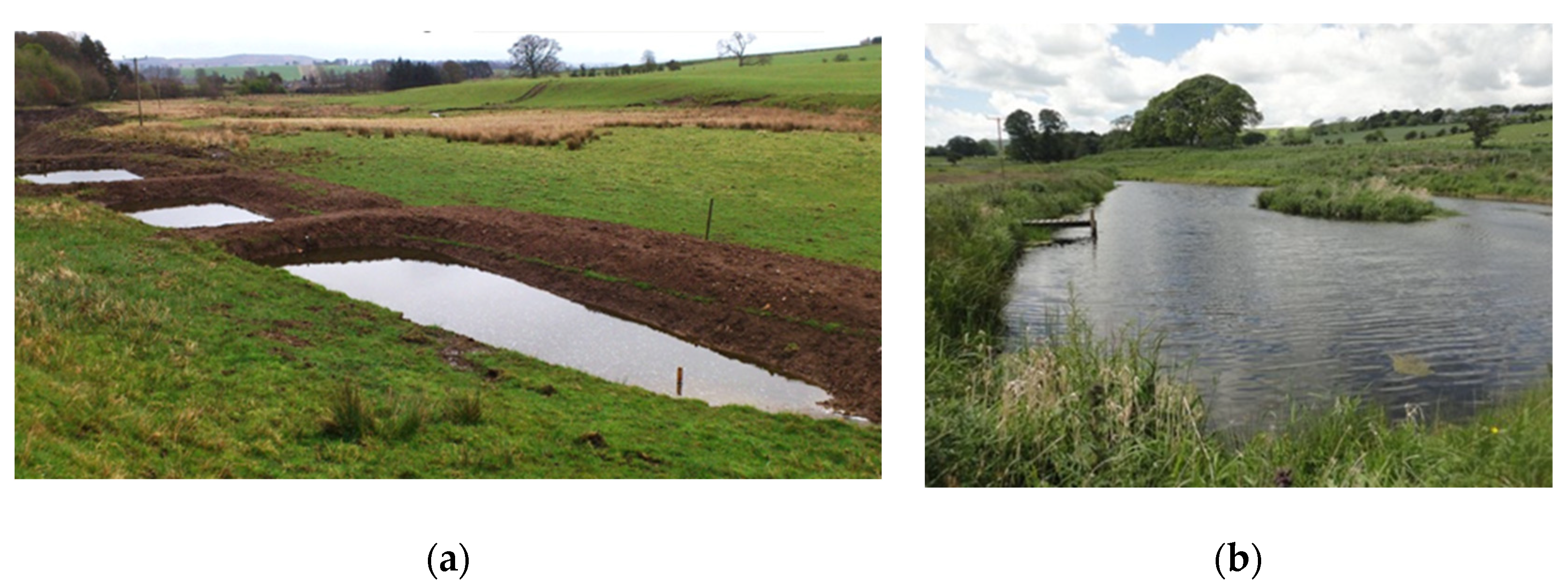
Offline ponds work best when interacting with a small (‘pocket floodplain’) or a large floodplain. They have the greatest potential to reduce flooding as they target the higher flood flows, filling only when the feature is needed. Figure 4, shows two examples of offline ponds. On the left is a small overland flow offline pond (capacity 400 m3), at Belford Burn and, on the right, a large offline pond (which is one of three ponds with a total capacity of 25,000 m3) in Coatham Woods (Co. Durham).
In all cases, a good estimate of peak flows and the local hydraulic conditions is needed if offline ponds are to perform at the optimum [16]. Thus, the key question is:
- How best to estimate the correct flow draw-off level for the pond to fill at its optimum?
This can be done using a design storm (as in Coatham Woods, Figure 4, for which a 1:100-year return interval storm was provided by the local EA team), but considerable uncertainty remains. A feature that allows for some uncertainty is recommended, and expert design knowledge should be used. If the opportunity arises, a scheme can be scaled up and a network of offline ponds designed to hold much larger volumes can be created. This can greatly enhance a larger flood scheme at a relatively low cost.
At Coatham Woods, Arup consultants designed three large ponds with adjustable draw-off structures giving total storage of 25,000 m3, which gave an estimated 10% reduction in peak flow for a 1:100-year design event by using a pond network model [16] combined with the CityCAT hydrodynamic model [47]. In this study, the concept of NFM Plus was introduced, which is intended to capture the transition from RAFs and NFM to more traditional river engineering and flood management methods. These methods deal with larger volumes of storage as opposed to RAFS and NFM measures [41] which are usually smaller than 10,000 m3.
Combinations of RAFs can work well together. For example, a woody leaky barrier can divert flow onto a floodplain containing an offline pond. Hence, one key RAF measure that is often overlooked is the draw off structure. On certain occasions, it is necessary to modify a riverbank and create a swale to convey flow onto a floodplain and into an offline pond or wetland. Alternatively, if too much flow enters the floodplain, a raised structure may be needed to stop the storage area from filling too soon. In all cases, the intake inflow must be controlled, and the use of observed flows plays an essential role in getting the design right. A structure that can be easily raised or lowered is recommended as part of an adaptive engineering approach. Hence, some local knowledge of the floodplain function is beneficial - if the whole floodplain is already inundated to a significant depth, then an RAF is not needed. However, if significant parts of a floodplain are not regularly inundated, then it can be utilised better or the flood depth made significantly deeper. In the case of Coatham Woods, the original channel had been deepened in the past and no water was entering the floodplain, hence the need for the swale draw-off structure. In the County Wexford case, too much flow entered the floodplain and quickly drowned out the offline pond, hence the inlet was raised to its optimum height.
Figure 5, shows two draw off structures. On the left is a cutting into the channel which feeds diverts flow into the offline pond shown in Figure 4a. On the right is a cutting into a bund with a raised structure to allow divert the appropriate amount of floodwater to flow onto the local floodplain [48].
There are several special cases that can be considered as RAFs, for example restored/improved floodplain wetlands and sediment traps. In all cases, they can be classed as RAFs if they are engineered to hold more flow in temporary storage zones or to slow velocities. For wetlands, it is recommended that a series of extra bunds can be added to hold back more flow during storm events. For all cases, the role of groundwater is vital, as discussed below.
We note here that specific wetland types and other sediment traps that perform a similar function are assumed to not perform well when full. However, any feature that spreads flow over the floodplain attenuates flow, especially if there is shallow water flow across rough vegetation. This process should commence earlier in a storm event in wetlands [49]. As higher flow also induces slow subsurface flow across a large domain (and the function of land drains) the question must be asked:
- How effectively can wetlands be used to slow floods if they are augmented with RAFs?
3. Scale and RAFs
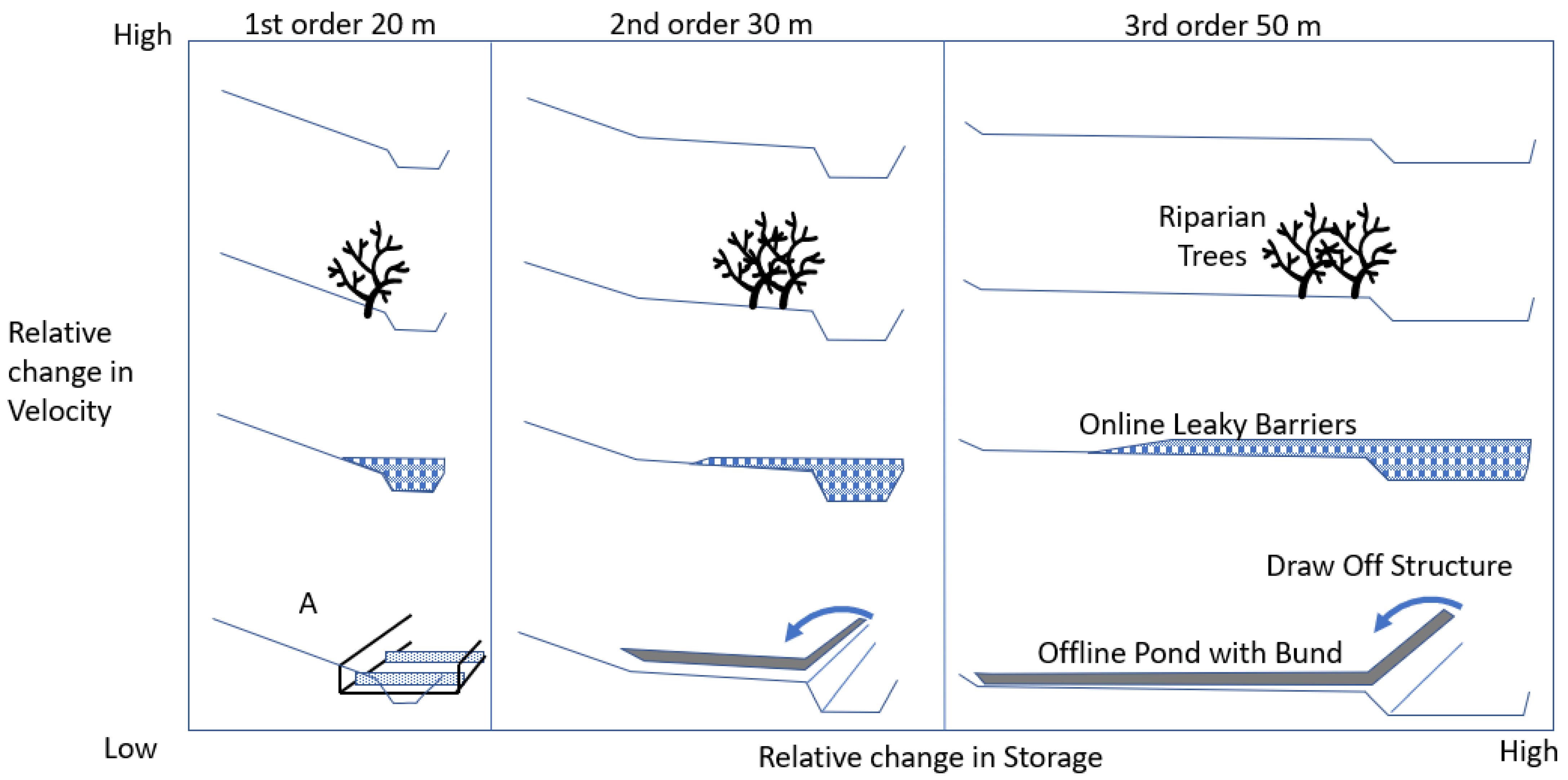
As the discussion above notes, there is a need to situate features in carefully chosen locations, considering the catchment scale and the opportunities offered by floodplains. So, here RAFs are classified according to scale, and key aspects of their function. In Figure 6, a range of conceptualised RAF designs is shown that are tied to scale. The axes are the change in velocity and change in storage relative to the original flow regime. In Quinn et al., [41] it was recommended that once the catchment area exceeds ~3 km2, RAFs crossing the river channel should be avoided as they may cause construction difficulty and are prone to being damaged or destroyed during large events. Further, beyond this scale, there is an increased likelihood of a large enough floodplain that can be utilised offline instead. However, this guideline has caveats. For example, the large woody debris feature shown on the left of Figure 2 operates on a catchment of area ~12 km2. However, this is just one of a series of well-built engineered barriers unlikely to move in floods. Smaller scale features (on the right) can create storage, but usually, the primary goal is to slow velocities and lower the erosive stream power. As the catchment scale increases, the opportunity to identify and use floodplains also increases. Finally, there is a trade-off between larger rural floodplains and the likely increased prevalence of roads, towns and other infrastructure that can complicate implementation needs (i.e., a feature must not be perceived to increase local flood risk or impact on nearby infrastructure). We argue that RAFs (and NFM) should target the lower Strahler stream order of upstream areas, but in the lower higher order systems downstream, NFM plus more traditional flood-engineered solutions are suggested. This raises the question:
- What is the maximum scale for NFM to be effective?
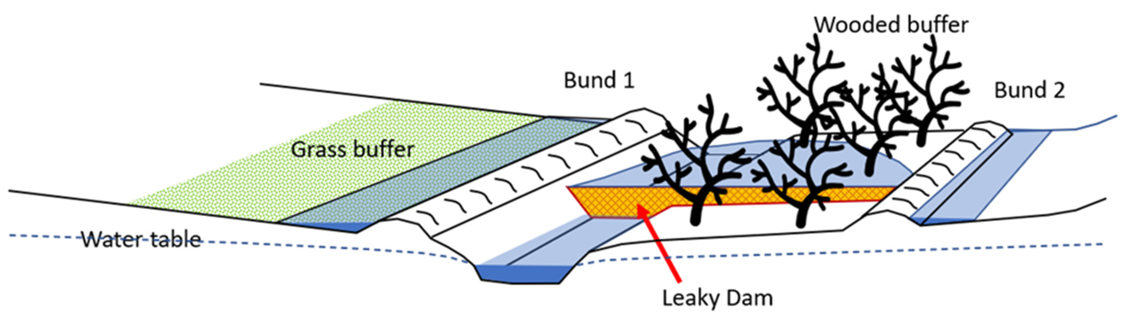
There are also opportunities for RAFs to work with other established land management options, a good example of which is the use of buffer strips, as these are well understood and are supported by a transparent funding structure (e.g., in Agri-Environmental schemes). Farmers are paid by the width of a buffer and the loss of production. Passive buffer zones/strips are here defined as a strip of riparian land that is not cultivated. A passive strip can work to slow flow and pollution, but they are often under-drained or easily overtopped by overland flow. An ‘active’ buffer would be an engineered modification to the buffer strip to perform more tasks, namely slowing and storing flow. Hence, a study by the EA and JHI called “3D Buffers” (sometimes referred to as ‘smart buffers’ or engineered buffers) looked at a wide range of measures that could make better use of buffer zones whilst remaining simple enough for uptake by farmers [50]. Various ways to slow and retain flow were considered, some of which are illustrated in Figure 7. The most preferred suggested intervention was the wooded riparian buffer strip, which can work well across low and high flow regimes. The RAF approach suggests that maximum benefit is gained by adding extra leaky barriers in the channel and backing up water into the buffer zone, to increase the residence time, slow velocities further and induce deep recharge. However, the uptake of these more ‘engineered’ schemes was perceived as less favourable by farmers [50]. Ideally, a farm ditch or small channel that has a buffering scheme highly alters the design to maximise reductions to flow velocities, create some storage and induce sedimentation. Thus, in Figure 7, opportunities to create either a leaky barrier in the ditch or a drain to back up water into the features on the buffer strip should be sought. Equally, the riparian area can be further engineered to store and retain high flows by creating new temporary online overland flow bunds.
4. Multiple Benefits
The multiple objectives of RAFs are important to consider as RAFs can potentially improve water quality, biodiversity and induce drought reduction. Multiple objectives are not fully addressed in detail here as this article is primarily a discussion of RAFs for NFM. However, we recommend that two key questions should always be asked:
- Can RAFs be designed to tackle a wider range of multiple objectives?
- Can sets of complementary RAFs be placed together to tackle a series of multiple objectives including flood reduction?
Many land use interventions such as buffer strips and wetlands can be effective NFM options and can work in tandem with RAFs. Finding opportunities to modify ditches to create sediment traps and provide significant NFM benefits needs to better be explored. If an NBS scheme is installed to improve water quality, there is a great opportunity to design the system to also provide NFM benefits. In the example shown in Figure 8, a farm ditch has been widened to capture sediment. The trap was proposed to protect the larger flood storage zone pond below from silting up over time. The pond thus provides flood protection while the sediment trap protects the pond’s flood storage capacity and aids with improving water quality (notably by capturing fine sediments). The study by Barber [51,52] shows that over 30 storms, an average of 49% of suspended sediment was removed, and 30% of total phosphorus was removed from the flow. In Figure 6, the example ditch marked as “A” is an example of a farm ditch that has been widened and a series of sediment traps installed. This opportunity is discussed further in Adams et al. [43] where agricultural pollution control mitigation is addressed.
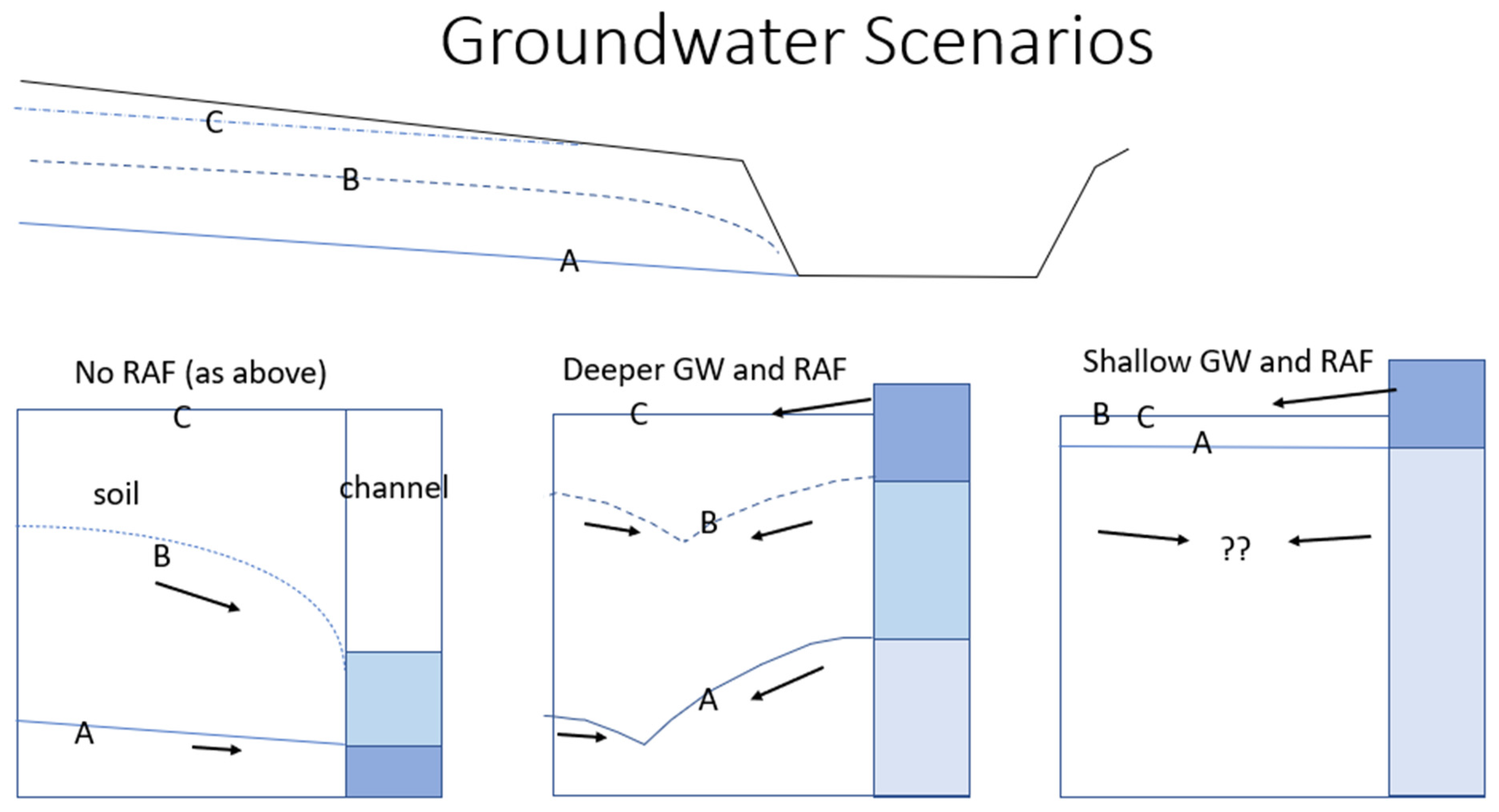
5. Groundwater and Residence Time
The role of NFM and RAFs in drought mitigation is a largely unexplored area of research in the context of UK catchment management. Most situations are complex. However, in Figure 9, a simple conceptual model of hillslope hydrology is shown that reflects some basic proposed groundwater and surface water runoff scenarios, showing:
- (A)
- a deeper water table that forms after a long hillslope and a long drainage period;
- (B)
- shallowing and speeding up the groundwater flow during a storm event;
- (C)
- saturation and the creation of variable source areas after an extensive rainfall period (it could also be a wetland).
The blue colour shades on the right indicate the position of the water level in the channel as a storm occurs. In an unmanaged scenario, on the left, the channel rises due to the rise in the groundwater level (no infiltration excess overland flow is assumed). This process is often referred to as ‘subsurface stormflow’ or ‘interflow’ giving high flow into the channel. Any storage and attenuation of infiltrating water in the soil column occur during the water table rise; however, the assumption is that this is Darcian flow, which means that the flow rate will increase during the storm as the head of water upstream rises and typically the soil’s hydraulic conductivity will increase closer to the top of the soil (leading to a flattening of the water table slope as it rises).
In a managed scenario with a RAF barrier, the deeper groundwater is still expected to rise, but the rise behind the barrier is likely to be more rapid. Hence, the head of water in the channel exceeds that in the soil. Darcian flow would now be expected to occur from the channel into the soil, hence at B, the soil storage is being taken up by the inflow from the channel. Equally, following Darcy’s law, the gradient from the soil toward the channel is lowered and so the flow rate should drop. Together, this situation should lower velocities and use up more soil storage. By the time the soil column is saturated, it might be expected that a well-designed leaky dam at high flow would be discharging some flow onto the hillslope itself. Again, there is a reduced head difference that should be reducing groundwater velocities from the hillslope to the channel across the whole pressurised water table domain. In the last scenario (Figure 9, on the right), there is a special case for a hillslope that is already close to saturation, as in a variable source area or designed wetland. There may be some capacity to store some water prior to the storm. However, the flow in the channel should quickly exceed that of the groundwater flow, and hence the positive head difference reduces groundwater flow velocities and subsurface stormflow should slow.
Further, slow-flowing or ponded water on the surface can keep the Darcian hydraulic gradient low over a larger groundwater domain or even allow infiltration into the soil. Thus, the whole flow regime is now flowing more slowly and attenuating. This would occur whilst the water level in the channel is high due to the presence of a barrier or pond. Similarly, a full pond can suppress local groundwater velocities and optimise storage in the groundwater away from the RAF itself. Given these considerations, based on Darcy’s law and channel dynamics, it is clear that the role of groundwater and the residence time of water held in the RAF needs to be better understood in order to maximise the potential benefits of drought reduction and improved water quality. Norbury et al., at Smithhills [45], show such a change in baseflow after building the RAF (Figure 2b). Longer recharge periods should also have some benefits for drought reduction. This section highlights:
- A better understanding of groundwater and residence times is needed for RAFs and NFM.
6. Scaling Up, Uncertainty and Modelling
The examples shown above, and the many questions raised show that there are still many issues in NFM that need to be addressed. As Figure 1 shows, a critical mass of features is needed to address flood risk. Currently, several elements of RAF design, which are required to guarantee that features run at the optimum performance, are not yet known. Equally, the issue of scaling up RAFs (and NFM generally) to the larger catchment scale needs more research. Better models and empirical evidence are needed. Model outputs need to be based on better robust empirical evidence of flow and a better understanding of RAF functioning, groundwater dynamics and pond status during large events. The tools and evidence used currently, whether they be hydrological rainfall runoff models or two-dimensional hydrodynamics models, are not able to fully address the scaling issue. Beven [34] warns that whilst we have modelling capability, the uncertainty is still too great. However, we argue that we must design and implement NFM schemes, even though we cannot fully determine the downstream impact. The outstanding question is:
- How do we design NFM schemes that address both local scale and larger spatial scale flood events?
In the case of the Belford scheme, UK (50 RAFs in 6 km2), the research concluded that the greater the volume of storage that was created the more confident they were at reducing both the magnitude of peak and delaying the time of peak [16,41]. This leads to the question:
- How much NFM can we afford?
The representation of RAFs within models and the accuracy of a model to pick out a subtle channel and RAF interactions is intractable. However, most of the observations shown in studies reported in WWNP, CIRIA and NERC NFM show that an increasing network of RAFs and NFM will delay the time of peak and reduce the peak flow [38,39,42]. There are few studies, other than at the local scale, where confidence is gained that a network of RAFs can reduce flood risk. Example studies include Belford Burn, Pickering, “Moors for the Future”, and Holnicote, which remain the pioneering studies. More recently, the NERC NFM projects have added significantly more evidence and questions. The question remains:
- Can a dense network of RAFs be simulated accurately?
There is still a need to gain a better understanding of both the hydraulic functioning (especially leakiness dynamics) of RAFs and the nature of groundwater interactions. This can only be done, for example, by using a combination of controlled experiments at the laboratory scale and detailed forensic analysis of flow and water levels for a range of in situ RAFs.
The WWNP [24] study drew a conclusion that NFM will work better in small catchments and small return interval events. This might be seen as a positive but has limited outcomes. However, there is always the option to implement more RAFs and plant more trees and use more NFM measures, but how many and at what scale? In the Belford scheme (6 km2), several 1:100-year events were observed during the detailed study period [16,41] and no extensive flooding occurred in Belford village in that period. So, the conclusion is that an extensive network of RAFs can work for large return interval storms because the events occurred in a small catchment. The key catchment characteristic is that the time of concentration of storms in small rapidly responding catchments is short compared to the duration of the flood-causing event. In essence, the Belford scheme is managing flash flooding, where intensity is the issue and not the flood volume. However, scaling up from the Belford scheme’s scale of 6 km2 large catchment scale to an order of 100 km2 remains problematic.
A final issue to consider is: what ‘design’ storm should be used (in the absence of substantial empirical observations) and where should the maximum flood reduction be targeted? There is a need to determine the role of NFM for flood mitigation if a large downstream conurbation is at risk (in a catchment of area greater than 100 km2). There is still a scaling issue in NFM ‘design’, as small towns and upstream infrastructure also need to be protected. So, should NFM target only scales at 10–20 km2 where it can work best? It is possible to downscale design storms for any location in the catchment or use locally observed floods (if that information is available)? It is worth noting that the design storm for the rivers draining through Carlisle, for example (catchment area ~2200 km2), could have a design duration of 24 h while the design storm for Belford is only 3–4 h duration. Hence, implicitly RAFs and local RAF networks are being designed at the scale where they are deployed. Chappel et al. propose in the QNFM project [38,53] the idea of ‘Intelligent design’ across catchments to capture the scale and variability of locations. This is very similar to the RAF classification scheme proposed here as part of the CSE concept [19], i.e., the nature of the RAFs’ designs should change with scale. Therefore, the design storm must be appropriate to the location of the RAF intervention. RAFs that slow velocities may be appropriate to rapidly responding catchments, while the addition of a large amount of new storage volume may be more appropriate to larger catchments. However, a broader philosophy of slowing flow across the landscape is needed, so that the catchment system is more resilient to climate change and other environmental challenges (as RAFs and NFM provide many other ecosystem services).
7. Conclusions
Whilst some positive steps have been demonstrated with RAFs (and NFM in general), we have raised a series of outstanding issues and questions as a constructive critique of the approach.
The reasoning for RAF implementation goes beyond flooding. We need to manage other environmental issues such as water quality, droughts and biodiversity loss. Thus, the opportunity to enhance or optimise any space given up to the environment should be explored and needs to be better understood. Equally, any NFM schemes should have multiple objectives.
Design innovation is possible, for example using ‘living barriers’ or using a suite of complementary RAFs to achieve multiple objectives. Often it is the individuality of the site and the needs of stakeholders that drive innovation.
The materials used to build RAFs, and the true cost of installation and maintenance regimes have not been addressed here. RAFs are relatively cheap compared to traditional flood management methods and can use cheap local materials. However, above it was suggested that large networks RAFs are needed at larger scales if we are to have confidence that higher flows can be managed. At these scales, extra levels of design and the number of RAFs needed may make the NFM schemes more expensive. One possible approach is to add as many RAFs within the landscape as is possible or affordable. The greater the attenuation capacity in the landscape, the wider the range of environmental benefits that can be achieved.
Uptake of RAFs will depend on imaginative payments, which will require extensive consultation, demonstration activities and policy-making, all of which can act as a barrier to uptake. Co-designed visualisation and communication tools such as those generated by the Decision Support Matrix (DSM) approach [54] can play a significant role in promoting stakeholder engagement and uptake. RAFs, NFM and nature-based solutions must become a normal part of farming, forestry and land management in general if it is to succeed. The role of socio-economic drivers is not covered in detail here, but progress must be made on all fronts [20,21,24].
Landscapes can be made more resilient as currently, channels are vulnerable to fast runoff and pollution with floods, droughts, and water quality issues. All NFM measures should be encouraged together and no one approach should gain supremacy. However, an honest evaluation of RAFs is needed, as it is not known yet if enough RAFs can be created to tackle various large event storms and address possible future climate change scenarios. Several questions have been posed and it is clear that fundamental research is required to address these questions, especially those related to scaling up and to the impact of RAFs at different time scales. However, it is clear that more runoff attenuation is needed across the whole of our upstream catchments to address our pressing environmental issues.
Author Contributions
Conceptualization, P.F.Q., M.E.W., C.J.M.H. and R.A.; methodology, P.F.Q., M.E.W., C.J.M.H. and R.A.; software, P.F.Q., M.E.W., C.J.M.H. and R.A.; validation, P.F.Q., M.E.W., C.J.M.H. and R.A., formal analysis, P.F.Q., M.E.W., C.J.M.H. and R.A., resources, P.F.Q., M.E.W., C.J.M.H. and R.A., data curation, P.F.Q., M.E.W., C.J.M.H. and R.A., writing, P.F.Q., M.E.W., C.J.M.H. and R.A., visualization, P.F.Q., M.E.W., C.J.M.H. and R.A., supervision, P.F.Q., M.E.W., C.J.M.H. and R.A., project administration, P.F.Q., M.E.W., C.J.M.H. and R.A., funding acquisition, P.F.Q., M.E.W., C.J.M.H. and R.A. All authors have read and agreed to the published version of the manuscript.
Funding
The Environment Agency Local Flood Levy and the Northumbria Regional Flood Defence Committee for commissioning and funding the Belford Proactive Flood Solutions project. PQ (lead author) would also like to acknowledge funding from the Environmental Protection Agency (Ireland) research grant (2018-W-LS-20) and the Scottish Government’s Rural and Environment Sciences Analytical Services Division (JHI-D2-2). RA would like to acknowledge funding from DAERA Evidence and Innovation Grant (number 19-4-03) which contributed to this article’s preparation.
Data Availability Statement
This manuscript reviewed accessible literature and no experimental data were used.
Acknowledgments
We would also like to thank Marc Stutter (James Hutton Institute) for assistance on the smarter buffers concept and David Brown (Environment Agency) and Mike Norbury (Mersey Forest Trust) for designing several innovative RAFs.
Conflicts of Interest
The authors declare no conflict of interest.
References
- Putro, B.; Kjeldsen, T.; Hutchins, M.; Miller, J. An empirical investigation of climate and land-use effects on water quantity and quality in two urbanising catchments in the southern United Kingdom. Sci. Total Environ. 2016, 548–549, 164–172. [Google Scholar] [CrossRef] [Green Version]
- HM Government. A Green Future: Our 25-Year Plan to Improve the Environment; OGL Crown Copyright: London, UK, 2018. Available online: https://www.gov.uk/government/publications/25-year-environment-plan (accessed on 21 November 2022).
- Blöschl, G.; Hall, J.; Viglione, A.; Perdigão, R.A.P.; Parajka, J.; Merz, B.; Lun, D.; Arheimer, B.; Aronica, G.T.; Bilibashi, A.; et al. Changing climate both increases and decreases European river floods. Nature 2019, 573, 108–111. [Google Scholar] [CrossRef] [PubMed]
- Hall, J.W.; Dawson, R.J.; Sayers, P.B.; Rosu, C.; Chatterton, J.B.; Deakin, R. A methodology for national-scale flood risk assessment. Proc. Inst. Civ. Eng.-Water Marit. Eng. 2003, 156, 235–247. [Google Scholar] [CrossRef]
- Environment Agency. Flooding in England: A National Assessment of Flood Risk. 2009. Available online: https://www.gov.uk/government/uploads/system/uploads/attachment_data/file/292928/geho0609bqds-e-e.pdf (accessed on 21 November 2022).
- House of Commons. Future Flood Prevention; Environment, Food and Rural Affairs Committee: London, UK, 2016; Second Report of Session 2016-17. HC 115; Available online: https://publications.parliament.uk/pa/cm201617/cmselect/cmenvfru/115/11502.htm (accessed on 21 November 2022).
- Committee on Climate Change. Adaptation Sub-Committee Report: Chapter 2: Flooding Indicators. 2012. Available online: https://www.theccc.org.uk/flooding-indicators/ (accessed on 29 September 2022).
- Kundzewicz, Z.W.; Pińskwar, I.; Brakenridge, G.R. Large floods in Europe, 1985–2009. Hydrol. Sci. J. 2012, 58, 1–7. [Google Scholar] [CrossRef]
- Scholz, M.; Yang, Q. Guidance on variables characterising water bodies including sustainable flood retention basins. Landsc. Urban Plan. 2010, 98, 190–199. [Google Scholar] [CrossRef]
- Pitt, M. The Pitt Review: Lessons Learned from the 2007 Floods; Cabinet Office: London, UK, 2008; Volume 505.
- Lane, S.N. Natural flood management. Wiley Interdisciplinary Reviews. Water 2017, 4, e1211. [Google Scholar]
- POST. Natural Flood Management POSTNOTE 396; Parliamentary Offices of Science and Technology: London, UK, 2011. [Google Scholar]
- Stratford, C.; Miller, J.; House, A.; Old, G.; Acreman, M.; Duenas-Lopez, M.A.; Nisbet, T.; Newman, J.; Burgess-Gamble, L.; Chappell, N.; et al. Do Trees in UK-Relevant River Catchments Influence Fluvial Flood Peaks? A Systematic Review; NERC/Centre for Ecology & Hydrology: Wallingford, UK, 2017. [Google Scholar]
- Evrard, O.; Vandaele, K.; van Wesemael, B.; Bielders, C.L. A grassed waterway and earthen dams to control muddy floods from a cultivated catchment of the Belgian loess belt. Geomorphology 2008, 100, 419–428. [Google Scholar] [CrossRef]
- Metcalfe, P.; Beven, K.; Hankin, B.; Lamb, R. A modelling framework for evaluation of the hydrological impacts of nature-based approaches to flood risk management, with application to in-channel interventions across a 29-km2 scale catchment in the United Kingdom. Hydrol. Process. 2017, 31, 1734–1748. [Google Scholar] [CrossRef] [Green Version]
- Nicholson, A.R.; O’Donnell, G.M.; Wilkinson, M.E.; Quinn, P.F. The potential of runoff attenuation features as a Natural Flood Management approach. J. Flood Risk Manag. 2019, 13, e12565. [Google Scholar] [CrossRef] [Green Version]
- Wilkinson, M.E.; Addy, S.; Quinn, P.F.; Stutter, M. Natural flood management: Small-scale progress and larger-scale challenges. Scott. Geogr. J. 2019, 135, 23–32. [Google Scholar] [CrossRef]
- Wilkinson, M.; Quinn, P.; Welton, P. Runoff management during the September 2008 floods in the Belford catchment, Northumberland. J. Flood Risk Manag. 2010, 3, 285–295. [Google Scholar] [CrossRef]
- Hewett, C.J.M.; Wilkinson, M.E.; Jonczyk, J.; Quinn, P.F. Catchment systems engineering: An holistic approach to catchment management. WIREs Water 2020, 7, e1417. [Google Scholar] [CrossRef]
- Waylen, K.A.; Holstead, K.; Colley, K.; Hopkins, J. Challenges to enabling and implementing Natural Flood Management in Scotland. J. Flood Risk Manag. 2017, 11, S1078–S1089. [Google Scholar] [CrossRef] [Green Version]
- Ferreira, C.S.; Kalantari, Z.; Hartmann, T.; Pereira, P. (Eds.) Nature-Based Solutions for Flood Mitigation: Environmental and Socio-Economic Aspects; Springer: Berlin/Heidelberg, Germany, 2022; Volume 107. [Google Scholar]
- Dadson, S.J.; Hall, J.W.; Murgatroyd, A.; Acreman, M.; Bates, P.; Beven, K.; Heathwaite, A.L.; Holden, J.; Holman, I.; Lane, S.N.; et al. A restatement of the natural science evidence concerning catchment-based ‘natural’ flood management in the UK. Proc. R. Soc. A Math. Phys. Eng. Sci. 2017, 473, 20160706. [Google Scholar] [CrossRef] [PubMed] [Green Version]
- McIntyre, N.; Ballard, C.; Bruen, M.; Bulygina, N.; Buytaert, W.; Cluckie, I.; Dunn, S.; Ehret, U.; Ewen, J.; Gelfan, A.; et al. Modelling the hydrological impacts of rural land use change. Water Policy 2013, 45, 737–754. [Google Scholar] [CrossRef]
- Environment Agency. Working with Natural Processes–Evidence Directory (SC150005); Environment Agency for England and Wales: Bristol, UK, 2017.
- JBA Trust, Lancaster Environment Centre and Lancaster University. Working with Natural Processes. Catalogue of Nature-Based Flood Risk Management Projects in the UK. 2020. Available online: http://naturalprocesses.jbahosting.com/#6/43.918/7.861 (accessed on 21 November 2022).
- DEFRA. NFM Projects Monitoring and Evaluation Tool v2.501. 2021. Available online: https://www.arcgis.com/apps/MapSeries/index.html?appid=5086d50ee3bc49f1bd25b039c7129c1a (accessed on 21 November 2022).
- SEPA. Natural Flood Management Handbook; Scottish Environment Protection Agency: Edinburgh, UK, 2015.
- Environment Agency. National Flood and Coastal Erosion Risk Management Strategy for England; HM Government: London, UK, 2019.
- Bulygina, N.; McIntyre, N.; Wheater, H. Bayesian conditioning of a rainfall-runoff model for predicting flows in ungauged catchments and under land use changes. Water Resour. Res. 2011, 47. [Google Scholar] [CrossRef] [Green Version]
- O’Donnell, G.; Ewen, J.; O’Connell, P. Sensitivity maps for impacts of land management on an extreme flood in the Hodder catchment, UK. Phys. Chem. Earth Parts A/B/C 2011, 36, 630–637. [Google Scholar] [CrossRef]
- O’Connell, P.E.; Ewen, J.; O’Donnell, G.; Quinn, P. Is there a link between agricultural land-use management and flooding? Hydrol. Earth Syst. Sci. 2007, 11, 96–107. [Google Scholar] [CrossRef] [Green Version]
- Hooijer, A.; Klijn, F.; Pedroli, G.B.M.; Van Os, A.G. Towards sustainable flood risk management in the Rhine and Meuse river basins: Synopsis of the findings of IRMA-SPONGE. River Res. Appl. 2004, 20, 343–357. [Google Scholar] [CrossRef]
- DeFries, R.; Eshleman, K.N. Land-use change and hydrologic processes: A major focus for the future. Hydrol. Process. 2004, 18, 2183–2186. [Google Scholar] [CrossRef]
- Beven, K. Environmental Modelling: An Uncertain Future? CRC Press: Boca Raton, FL, USA, 2018. [Google Scholar]
- Ewen, J.; O’Donnell, G.; Burton, A.; O’Connell, E. Errors and uncertainty in physically-based rainfall-runoff modelling of catchment change effects. J. Hydrol. 2006, 330, 641–650. [Google Scholar] [CrossRef]
- Pappenberger, F.; Beven, K.J. Ignorance is bliss: Or seven reasons not to use uncertainty analysis. Water Resour. Res. 2006, 42. [Google Scholar] [CrossRef]
- Engineering with Nature. World ATLAS, US Core of Engineers—ERDC-EL SR-18-8 Hardback File.pdf. 2019. Available online: https://ewn.erdc.dren.mil/?page_id=138 (accessed on 21 November 2022).
- NERC NFM Final Meeting. 2022. Available online: https://research.reading.ac.uk/nerc-nfm/nfm-finale-event-online/ (accessed on 21 November 2022).
- CIRIA. The Natural Flood Management Manual (C802F). 2022. Available online: https://www.ciria.org/ItemDetail?iProductCode=C802F&Category=FREEPUBS&WebsiteKey=a054c7b1-c241-4dd4-9ec1-38afd4a55683 (accessed on 21 November 2022).
- Lashford, C.; Lavers, T.; Reaney, S.; Charlesworth, S.; Burgess-Gamble, L.; Dale, J. Sustainable Catchment-Wide Flood Management: A Review of the Terminology and Application of Sustainable Catchment Flood Management Techniques in the UK. Water 2022, 14, 1204. [Google Scholar] [CrossRef]
- Quinn, P.; O’Donnell, G.; Nicholson, A.; Wilkinson, M.; Owen, G.; Jonczyk, J.; Barber, N.; Hardwick, M.; Davies, G. Potential Use of Runoff Attenuation Features in Small Rural Catchments for Flood Mitigation; Royal Haskoning and Environment Agency Report; Joint Newcastle University: Newcastle upon Tyne, UK, 2013. [Google Scholar]
- Wilkinson, M.; Quinn, P.; Barber, N.; Jonczyk, J. A framework for managing runoff and pollution in the rural landscape using a Catchment Systems Engineering approach. Sci. Total Environ. 2014, 468–469, 1245–1254. [Google Scholar] [CrossRef] [PubMed]
- Adams, R.; Quinn, P.; Barber, N.; Reaney, S. The Role of Attenuation and Land Management in Small Catchments to Remove Sediment and Phosphorus: A Modelling Study of Mitigation Options and Impacts. Water 2018, 10, 1227. [Google Scholar] [CrossRef] [Green Version]
- Allot, T.; Shuttleworth, E.; Evans, M.; Agnew, C.; Pilkington, M.; Spencer, T.; Walker, J. Annex 5: Flood Risk. Restoration of Blanket Bogs. 2015. Available online: https://www.moorsforthefuture.org.uk/__data/assets/pdf_file/0018/91206/Summary.a.pdf (accessed on 21 November 2022).
- Norbury, M.; Phillips, H.; Macdonald, N.; Brown, D.; Boothroyd, R.; Wilson, C.; Quinn, P.; Shaw, D. Quantifying the hydrological implications of pre- and post-installation willowed engineered log jams in the Pennine Uplands, NW England. J. Hydrol. 2021, 603, 126855. [Google Scholar] [CrossRef]
- Shropshire Council. 2022. Available online: https://newsroom.shropshire.gov.uk/2022/05/national-award-innovative-nature-based-approach-corvedale-flooding/ (accessed on 21 November 2022).
- Glenis, V.; Kutija, V.; Kilsby, C. A fully hydrodynamic urban flood modelling system representing buildings, green space and interventions. Environ. Model. Softw. 2018, 109, 272–292. [Google Scholar] [CrossRef] [Green Version]
- SloWaters. 2022. Available online: https://nwrmireland.wordpress.com/slowaters/ (accessed on 21 November 2022).
- Acreman, M.; Holden, J. How Wetlands Affect Floods. Wetlands 2013, 33, 773–786. [Google Scholar] [CrossRef] [Green Version]
- Environment Agency. 3D Buffer Strips: Designed to Deliver More for the Environment; Environment Agency: Bristol, UK, 2020. Available online: https://www.gov.uk/government/publications/3d-buffer-strips-designed-to-deliver-more-for-the-environment (accessed on 21 November 2022).
- Barber, N. Sediment, Nutrient and Runoff Management and Mitigation in Rural Catchments. Ph.D. Thesis, Newcastle University, Newcastle Upon Tyne, UK, 2014. [Google Scholar]
- Barber, N.J.; Quinn, P.F. Mitigating diffuse water pollution from agriculture using soft-engineered runoff attenuation features. Area 2012, 44, 454–462. [Google Scholar] [CrossRef]
- Hankin, B.; Craigen, I.; Chappell, N.A.; Page, T.; Metcalfe, P.; Rose, S. Strategic Investigation of Natural Flood Management in Cumbria; Jeremy Benn Associates: Skipton, UK, 2016; Available online: http://naturalcourse.co.uk/uploads/2017/04/2016s4667-Rivers-Trust-Life-IP-NFM-Opportunities-Technical-Report-v8.0.pdf (accessed on 21 November 2022).
- Hewett, C.J.M.; Quinn, P.F.; Wilkinson, M.E. The Decision Support Matrix (DSM) Approach to Reducing Environmental Risk in Farmed Landscapes. Agric. Water Manag. 2016, 172, 74–82. [Google Scholar] [CrossRef]
Figure 1.
A Catchment Systems Engineering approach to water management adapted from Hewett et al. [19]. Here we assume the catchment is about 10–20 km2.
Figure 1.
A Catchment Systems Engineering approach to water management adapted from Hewett et al. [19]. Here we assume the catchment is about 10–20 km2.

Figure 2.
Large woody/engineered log barriers: (a) Tees Rivers Trust in Coatham Beck, Co. Durham, in collaboration with EA, Forestry Commission, Stockton Borough Council, Arup and Newcastle University; (b) Smithhills, Mersey Forest, Liverpool University and EA [46] (photo by Norbury).
Figure 2.
Large woody/engineered log barriers: (a) Tees Rivers Trust in Coatham Beck, Co. Durham, in collaboration with EA, Forestry Commission, Stockton Borough Council, Arup and Newcastle University; (b) Smithhills, Mersey Forest, Liverpool University and EA [46] (photo by Norbury).

Figure 3.
Online ponds: Overland flow interception at (a) Belford Burn catchment and channel pond. (b) Slatey Sike positioned at 1 km2 along the channel (Tyne Rivers Trust and Newcastle University), the arrow indicates approximately 10 m for the bund width.
Figure 3.
Online ponds: Overland flow interception at (a) Belford Burn catchment and channel pond. (b) Slatey Sike positioned at 1 km2 along the channel (Tyne Rivers Trust and Newcastle University), the arrow indicates approximately 10 m for the bund width.

Figure 4.
Offline ponds at (a) Belford Burn as it is filling and (b) Coatham Woods, Co. Durham, shortly after a storm event.
Figure 4.
Offline ponds at (a) Belford Burn as it is filling and (b) Coatham Woods, Co. Durham, shortly after a storm event.

Figure 5.
Draw off structures at Coatham Woods lowering the bank, Co. Durham (a) and SloWaters Project Co. Wexford, Ireland (b) raising the overflow level [48].
Figure 5.
Draw off structures at Coatham Woods lowering the bank, Co. Durham (a) and SloWaters Project Co. Wexford, Ireland (b) raising the overflow level [48].

Figure 6.
A classification of RAF features. The width of the effective inundation zone increases with scale and Strahler order. Label A is a highly modified widened farm ditch with sediment traps.
Figure 6.
A classification of RAF features. The width of the effective inundation zone increases with scale and Strahler order. Label A is a highly modified widened farm ditch with sediment traps.

Figure 7.
An example of ‘3D buffers’ or ‘Smart Buffers showing both passive and active interventions across the ditch/stream and riparian area, inspired by the 3D buffers project [51]. The choice of vegetation and the positioning of bunds and leaky dams can greatly increase the effectiveness.
Figure 7.
An example of ‘3D buffers’ or ‘Smart Buffers showing both passive and active interventions across the ditch/stream and riparian area, inspired by the 3D buffers project [51]. The choice of vegetation and the positioning of bunds and leaky dams can greatly increase the effectiveness.

Figure 8.
(a) In Netherton Burn (Northumberland), a ditch has been modified to create sediment traps [51] and (b) a permanent pond with 1m of available flood storage. This RAF protects a larger flood storage pond immediately downstream which provided the main RAF storage requirements.
Figure 8.
(a) In Netherton Burn (Northumberland), a ditch has been modified to create sediment traps [51] and (b) a permanent pond with 1m of available flood storage. This RAF protects a larger flood storage pond immediately downstream which provided the main RAF storage requirements.

Figure 9.
Groundwater (GW) dynamics and subsurface flow velocities for several scenarios: A is the groundwater position before the storm vent; B during the storm and C is when groundwater saturation is reached.
Figure 9.
Groundwater (GW) dynamics and subsurface flow velocities for several scenarios: A is the groundwater position before the storm vent; B during the storm and C is when groundwater saturation is reached.

Publisher’s Note: MDPI stays neutral with regard to jurisdictional claims in published maps and institutional affiliations. |
© 2022 by the authors. Licensee MDPI, Basel, Switzerland. This article is an open access article distributed under the terms and conditions of the Creative Commons Attribution (CC BY) license (https://creativecommons.org/licenses/by/4.0/).
Share and Cite
MDPI and ACS Style
Quinn, P.F.; Hewett, C.J.M.; Wilkinson, M.E.; Adams, R. The Role of Runoff Attenuation Features (RAFs) in Natural Flood Management. Water 2022, 14, 3807. https://doi.org/10.3390/w14233807
AMA Style
Quinn PF, Hewett CJM, Wilkinson ME, Adams R. The Role of Runoff Attenuation Features (RAFs) in Natural Flood Management. Water. 2022; 14(23):3807. https://doi.org/10.3390/w14233807
Chicago/Turabian StyleQuinn, Paul Francis, Caspar J. M. Hewett, Mark E. Wilkinson, and Russell Adams. 2022. "The Role of Runoff Attenuation Features (RAFs) in Natural Flood Management" Water 14, no. 23: 3807. https://doi.org/10.3390/w14233807
Note that from the first issue of 2016, this journal uses article numbers instead of page numbers. See further details here.