
A Review of Current Capabilities and Science Gaps in Water Supply Data, Modeling, and Trends for Water Availability Assessments in the Upper Colorado River Basin

 , , , ,
Abstract
:1. Introduction
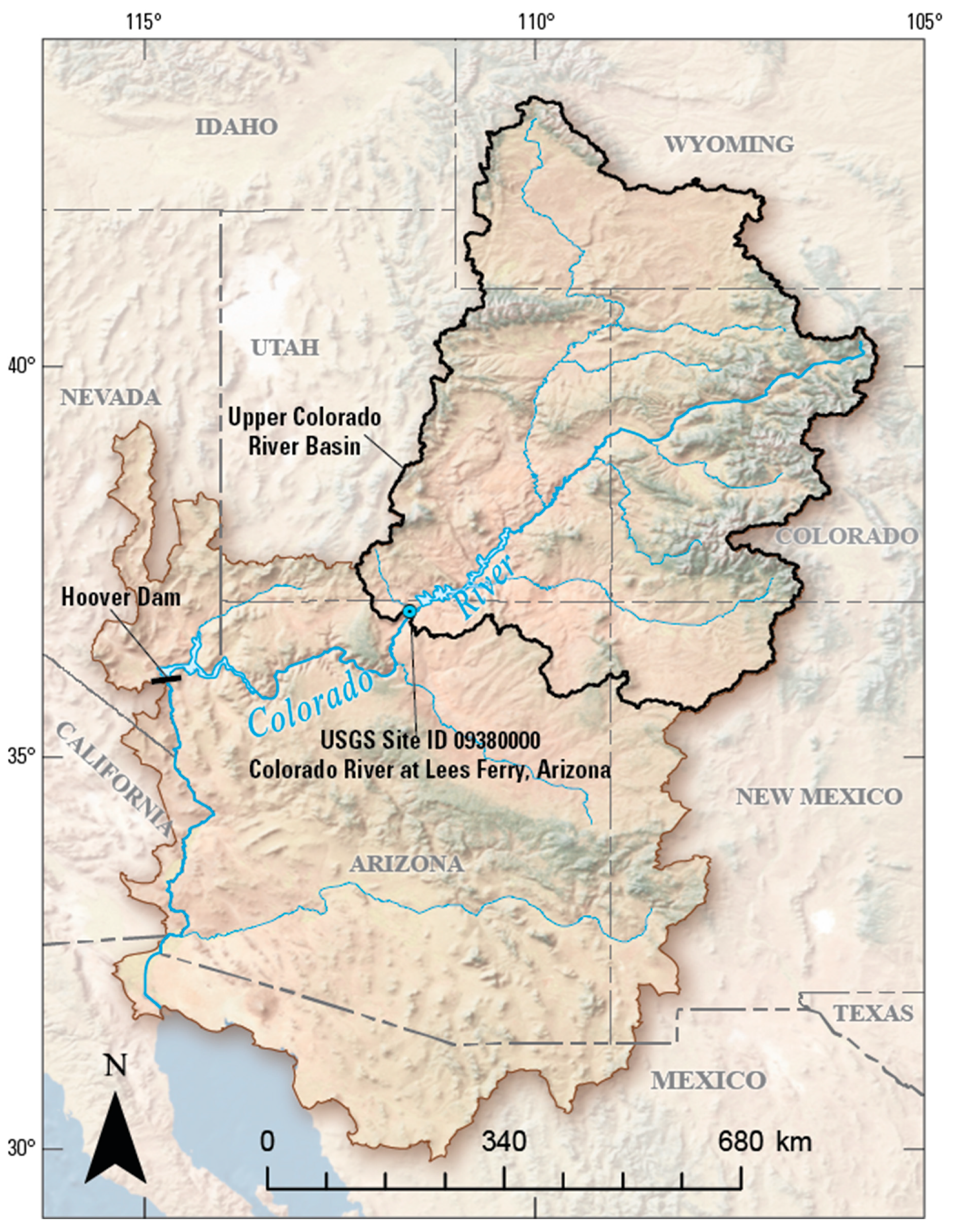
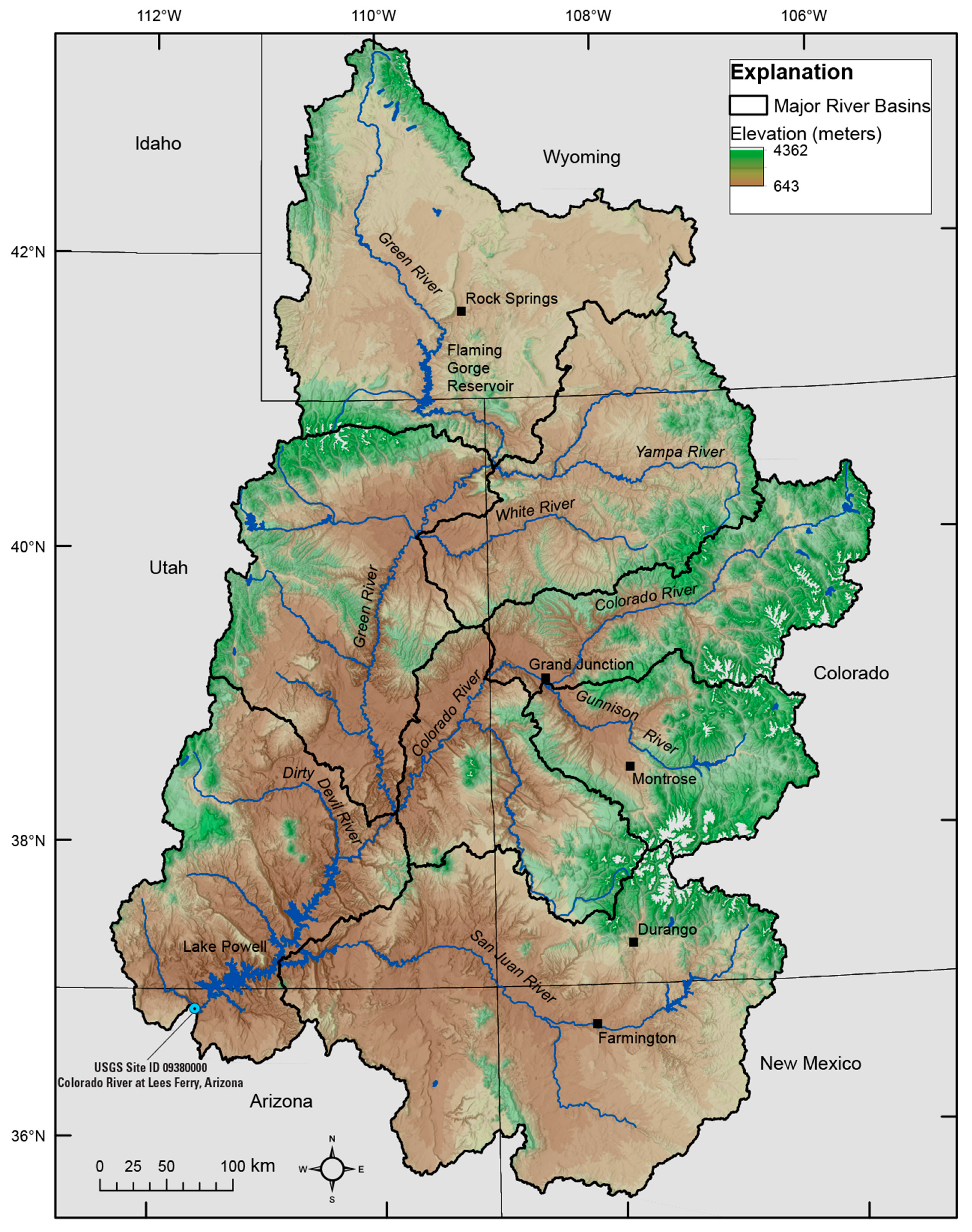
2. Background
UCOL Hydrology, Water Quality, and Water Use
3. Review of Current UCOL Data, Modeling, and Trend Capabilities
3.1. Streamflow
3.1.1. Data
3.1.2. Modeling Capabilities
3.1.3. Trends
3.2. Salinity in Groundwater and Surface Water
3.2.1. Data
3.2.2. Modeling Capabilities
Ground Water
Surface Water
3.2.3. Trends
3.3. Groundwater Levels and Storage
3.3.1. Data
3.3.2. Modeling Capabilities
3.3.3. Trends
3.4. Snow
3.4.1. Data
3.4.2. Modeling Capabilities
3.4.3. Trends
4. Summary and Conclusions
Supplementary Materials
Author Contributions
Funding
Data Availability Statement
Acknowledgments
Conflicts of Interest
References
- Bureau of Reclamation. Colorado River Basin Water Supply and Demand Study; Bureau of Reclamation: Denver, CO, USA, 2012. Available online: https://www.usbr.gov/lc/region/programs/crbstudy/finalreport/studyrpt.html (accessed on 18 July 2022).
- Bureau of Reclamation. The Colorado River Compact of 1922; Bureau of Reclamation: Denver, CO, USA, 1922. Available online: https://www.usbr.gov/lc/region/pao/pdfiles/crcompct.pdf (accessed on 18 July 2022).
- U.S. Geological Survey. “USGS National Water Information: Colorado River at Lees Ferry, AZ”. Available online: https://waterdata.usgs.gov/nwis/inventory?agency_code=USGS&site_no=09380000 (accessed on 18 July 2022).
- U.S. Geological Survey. “USGS Water Data for the Nation” U.S. Geological Survey National Water Information System Database. Available online: https://waterdata.usgs.gov/nwis (accessed on 18 July 2022).
- IBWC. Utilization of Waters of the Colorado and Tijuana Rivers and of the Rio Grande; IBWC: Washington, DC, USA, 1944. Available online: https://www.ibwc.gov/Files/1944Treaty.pdf (accessed on 18 July 2022).
- Bureau of Reclamation. “Colorado River Basin Natural Flow and Salt Data”. Available online: https://www.usbr.gov/lc/region/g4000/NaturalFlow/documentation.html (accessed on 18 July 2022).
- Bureau of Reclamation. “Reclamation Announces 2022 Operating Conditions for Lake Powell and Lake Mead”. Available online: https://www.usbr.gov/newsroom/#/news-release/3950 (accessed on 18 July 2022).
- Colorado River Commission of Nevada. “Drought and Colorado River Declared Shortage”. Available online: http://crc.nv.gov/index.php?p=info&s=drought (accessed on 7 August 2022).
- Bureau of Reclamation. “Interior Department Announces Actions to Protect Colorado River System, Sets 2023 Operating Conditions for Lake Powell and Lake Mead”. Available online: https://www.doi.gov/pressreleases/interior-department-announces-actions-protect-colorado-river-system-sets-2023 (accessed on 24 August 2022).
- Lukas, J.; Payton, E. Colorado River Basin Climate and Hydrology: State of the Science; University of Colorado: Boulder, CO, USA, 2020; Available online: https://scholar.colorado.edu/concern/reports/8w32r663z (accessed on 18 July 2022).
- Miller, M.P.; Susong, D.D.; Shope, C.L.; Heilweil, V.M.; Stolp, B.J. Continuous Estimation of Baseflow in Snowmelt-Dominated Streams and Rivers in the Upper Colorado River Basin: A Chemical Hydrograph Separation Approach. Water Resour. Res. 2014, 50, 6986–6999. [Google Scholar] [CrossRef]
- Miller, M.P.; Buto, S.G.; Susong, D.D.; Rumsey, C.A. The Importance of Base Flow in Sustaining Surface Water Flow in the Upper Colorado River Basin. Water Resour. Res. 2016, 52, 3547–3562. [Google Scholar] [CrossRef]
- Rumsey, C.A.; Miller, M.P.; Schwarz, G.E.; Hirsch, R.M.; Susong, D.D. The Role of Baseflow in Dissolved Solids Delivery to Streams in the Upper Colorado River Basin. Hydrol. Process. 2017, 31, 4705–4718. [Google Scholar] [CrossRef]
- Rumsey, C.A.; Miller, M.P.; Susong, D.D.; Tillman, F.D.; Anning, D.W. Regional Scale Estimates of Baseflow and Factors Influencing Baseflow in the Upper Colorado River Basin. J. Hydrol. Reg. Stud. 2015, 4, 91–107. [Google Scholar] [CrossRef] [Green Version]
- Miller, O.L.; Miller, M.P.; Longley, P.C.; Alder, J.R.; Bearup, L.A.; Pruitt, T.; Jones, D.K.; Putman, A.L.; Rumsey, C.A.; McKinney, T. How Will Baseflow Respond to Climate Change in the Upper Colorado River Basin? Geophys. Res. Lett. 2021, 48, e2021GL095085. [Google Scholar] [CrossRef]
- Winter, T.C.; Harvey, J.W.; Franke, O.L.; Alley, W.M. Ground Water and Surface Water—A Single Resource; U.S. Geological Survey Circular 1139; U.S. Geological Survey: Reston, VA, USA, 1998; 79p. Available online: https://pubs.usgs.gov/circ/1998/1139/report.pdf (accessed on 18 July 2022).
- Anning, D.W.; Bauch, N.J.; Gerner, S.J.; Flynn, M.E.; Hamlin, S.N.; Moore, S.J.; Schaefer, D.H.; Anderholm, S.K.; Spangler, L.E. Dissolved Solids in Basin-Fill Aquifers and Streams in the Southwestern United States; Version 1.1.; U.S. Geological Survey Scientific Investigations Report 2006-5315; U.S. Geological Survey: Reston, VA, USA, 2007. Available online: http://pubs.er.usgs.gov/publication/sir20065315 (accessed on 18 July 2022).
- Kenney, T.A.; Gerner, S.J.; Buto, S.G.; Spangler, L.E. Spatially Referenced Statistical Assessment of Dissolved-Solids Load Sources and Transport in Streams of the Upper Colorado River Basin; U.S. Geological Survey Scientific Investigations Report 2009-5007; U.S. Geological Survey: Reston, VA, USA, 2009. Available online: https://pubs.usgs.gov/sir/2009/5007/ (accessed on 18 July 2022).
- Leib, K.J.; Linard, J.I.; Williams, C.A. Statistical Relations of Salt and Selenium Loads to Geospatial Characteristics of Corresponding Subbasins of the Colorado and Gunnison Rivers in Colorado; U.S. Geological Survey Scientific Investigations Report 2012-5003; U.S. Geological Survey: Reston, VA, USA, 2012. Available online: https://pubs.usgs.gov/sir/2012/5003/ (accessed on 18 July 2022).
- Miller, M.P.; Buto, S.G.; Lambert, P.M.; Rumsey, C.A. Enhanced and Updated Spatially Referenced Statistical Assessment of Dissolved-Solids Load Sources and Transport in Streams of the Upper Colorado River Basin; U.S. Geological Survey Scientific Investigations Report 2017-5009; U.S. Geological Survey: Reston, VA, USA, 2017. [Google Scholar] [CrossRef] [Green Version]
- Colorado River Basin Salinity Control Forum. Colorado River Basin Salinity Control Program Briefing Document; Colorado River Basin Salinity Control Forum: Bountiful, UT, USA, 2013; Available online: http://www.coloradoriversalinity.org/docs/CRBSCP%20Briefing%20Document%202013%20Feb%204.pdf (accessed on 18 July 2022).
- IBWC. Permanent and Definitive Solution to the International Problem of the Salinity of the Colorado River; IBWC: Washington, DC, USA, 1973. Available online: https://www.usbr.gov/lc/region/pao/pdfiles/min242.pdf (accessed on 18 July 2022).
- Tillman, F.D.; Coes, A.L.; Anning, D.W.; Mason, J.P.; Coplen, T.B. Investigation of Recent Decadal-Scale Cyclical Fluctuations in Salinity in the Lower Colorado River. J. Environ. Manag. 2019, 235, 442–452. [Google Scholar] [CrossRef]
- Maupin, M.A.; Ivahnenko, T.I.; Bruce, B. Estimates of Water Use and Trends in the Colorado River Basin, Southwestern United States, 1985–2010; U.S. Geological Survey Scientific Investigations Report 2018-5049; U.S. Geological Survey: Reston, VA, USA, 2018. [Google Scholar] [CrossRef]
- U.S. Geological Survey. “USGS Surface-Water Data for the Nation”. Available online: https://waterdata.usgs.gov/nwis/sw (accessed on 18 July 2022).
- U.S. Geological Survey. “How to Use Next Generation Monitoring Location Pages”. Available online: https://waterdata.usgs.gov/blog/how-to-use-nextgen-pages/ (accessed on 2 October 2022).
- U.S. Geological Survey. “USGS National Water Dashboard”. Available online: https://dashboard.waterdata.usgs.gov/app/nwd/?aoi=default (accessed on 18 July 2022).
- Colorado Department of Natural Resources. “Colorado Department of Natural Resources Decision Support Systems”. Available online: https://dwr.state.co.us/Tools/Stations?Stations=All (accessed on 18 July 2022).
- Wyoming State Engineer’s Office. “Wyoming State Engineer’s Office Web Portal”. Available online: https://seoflow.wyo.gov/ (accessed on 18 July 2022).
- Northern Water. “Northern Water Data Viewer”. Available online: https://data.northernwater.org/applications/public.html?publicuser=Public#waterdata/stationoverview (accessed on 18 July 2022).
- Bureau of Reclamation. “Bureau of Reclamation Upper Colorado Basin Water Operations”. Available online: https://www.usbr.gov/uc/water/ (accessed on 18 July 2022).
- Kakalia, Z.; Varadharajan, C.; Alper, E.; Brodie, E.L.; Burrus, M.; Carroll, R.W.H.; Christianson, D.S.; Dong, W.; Hendrix, V.C.; Henderson, M.; et al. The Colorado East River Community Observatory Data Collection. Hydrol. Process. 2021, 35, e14243. [Google Scholar] [CrossRef]
- U.S. Geological Survey. “USGS Water Basics Glossary”. Available online: https://water.usgs.gov/water-basics_glossary.html (accessed on 3 September 2022).
- Regan, R.S.; Markstrom, S.L.; Hay, L.E.; Viger, R.J.; Norton, P.A.; Driscoll, J.M.; LaFontaine, J.H. Description of the National Hydrologic Model for Use with the Precipitation-Runoff Modeling System (PRMS); U.S. Geological Survey Techniques and Methods, book 6, chap B9; U.S. Geological Survey: Reston, VA, USA, 2018. [Google Scholar] [CrossRef]
- Regan, R.S.; LaFontaine, J.H. Documentation of the Dynamic Parameter, Water-Use, Stream and Lake Flow Routing, and Two Summary Output Modules and Updates to Surface-Depression Storage Simulation and Initial Conditions Specification Options with the Precipitation-Runoff Modeling System (PRMS); U.S. Geological Survey Techniques and Methods, book 6, chap. B8; U.S. Geological Survey: Reston, VA, USA, 2017. [Google Scholar] [CrossRef]
- Markstrom, S.L.; Regan, R.S.; Hay, L.E.; Viger, R.L.; Webb, R.M.T.; Payn, R.A.; LaFontaine, J.H. PRMS-IV, the Precipitation-Runoff Modeling System, Version 4; U.S. Geological Survey Techniques and Methods, book 6, chap. B7; U.S. Geological Survey: Reston, VA, USA, 2015. [Google Scholar] [CrossRef]
- Clark, M.P.; Nijssen, B.; Lundquist, J.D.; Kavetski, D.; Rupp, D.E.; Woods, R.A.; Freer, J.E.; Gutmann, E.D.; Wood, A.W.; Brekke, L.D.; et al. A Unified Approach for Process-based Hydrologic Modeling: 1. Modeling Concept. Water Resour. Res. 2015, 51, 2498–2514. [Google Scholar] [CrossRef]
- Knoben, W.J.M.; Clark, M.P.; Bales, J.; Bennett, A.; Gharari, S.; Marsh, C.B.; Nijssen, B.; Pietroniro, A.; Spiteri, R.J.; Tang, G.; et al. Community Workflows to Advance Reproducibility in Hydrologic Modeling: Separating Model-Agnostic and Model-Specific Configuration Steps in Applications of Large-Domain Hydrologic Models. Earth Space Sci. Open Arch. 2021, 52, e2021WR031753. [Google Scholar] [CrossRef]
- Wood, A.W.; Mizukami, N.; Clark, M.P.; Newman, A.J.; Liu, H.; Sturtevant, J.; Bennett, A.; Llewellyn, D.; Broman, D.; McGuire, M.; et al. A New SUMMA and MizuRoute Hydrologic Modeling Resource for US Water Applications. In Proceedings of the American Geophysical Union Fall Meeting, Chicago, IL, USA, 1–17 December 2020; Available online: https://agu.confex.com/agu/fm20/meetingapp.cgi/Paper/765282 (accessed on 18 July 2022).
- Maxwell, R.M. A Terrain-Following Grid Transform and Preconditioner for Parallel, Large-Scale, Integrated Hydrologic Modeling. Adv. Water Resour. 2013, 53, 109–117. [Google Scholar] [CrossRef]
- Kollet, S.J.; Maxwell, R.M. Integrated Surface–Groundwater Flow Modeling: A Free-Surface Overland Flow Boundary Condition in a Parallel Groundwater Flow Model. Adv. Water Resour. 2006, 29, 945–958. [Google Scholar] [CrossRef] [Green Version]
- Jones, J.E.; Woodward, C.S. Newton–Krylov-Multigrid Solvers for Large-Scale, Highly Heterogeneous, Variably Saturated Flow Problems. Adv. Water Resour. 2001, 24, 763–774. [Google Scholar] [CrossRef] [Green Version]
- Ashby, S.F.; Falgout, R.D. A Parallel Multigrid Preconditioned Conjugate Gradient Algorithm for Groundwater Flow Simulations. Nucl. Sci. Eng. 1996, 124, 145–159. [Google Scholar] [CrossRef]
- Tran, H.; Zhang, J.; Cohard, J.; Condon, L.E.; Maxwell, R.M. Simulating Groundwater-Streamflow Connections in the Upper Colorado River Basin. Groundwater 2020, 58, 392–405. [Google Scholar] [CrossRef] [PubMed]
- Tran, H.; Zhang, J.; O’Neill, M.M.; Ryken, A.; Condon, L.E.; Maxwell, R.M. A Hydrological Simulation Dataset of the Upper Colorado River Basin from 1983 to 2019. Sci. Data 2022, 9, 16. [Google Scholar] [CrossRef]
- Masbruch, M.; Dickinson, J. Quantifying the Contribution of Regional Aquifers to Stream Flow in the Upper Colorado River Basin. In Proceedings of the American Geophysical Union, Fall Meeting, New Orleans, LA, USA, 11–15 December 2017; Available online: https://ui.adsabs.harvard.edu/abs/2017AGUFM.H51G1350M/abstract (accessed on 18 July 2022).
- McCabe, G.J.; Wolock, D.M. The Water-Year Water Balance of the Colorado River Basin. JAWRA J. Am. Water Resour. Assoc. 2020, 56, 724–737. [Google Scholar] [CrossRef]
- McCabe, G.J.; Wolock, D.M. Warming May Create Substantial Water Supply Shortages in the Colorado River Basin. Geophys. Res. Lett. 2007, 34, L22708. [Google Scholar] [CrossRef] [Green Version]
- Milly, P.C.D.; Dunne, K.A. Colorado River Flow Dwindles as Warming-Driven Loss of Reflective Snow Energizes Evaporation. Science 2020, 367, 1252–1255. [Google Scholar] [CrossRef]
- Stern, M. Drought, Wildfire, and Snowpack in the Colorado River Basin: Lessons from the Basin Characterization Model. In Proceedings of the USGS Rocky Mountain Region Seminar, Denver, CO, USA, 25 August 2021. [Google Scholar]
- Schwarz, G.; Hoos, A.B.; Alexander, R.B.; Smith, R.A. The SPARROW Surface Water-Quality Model: Theory, Applications and User Documentation; U.S. Geological Survey Techniques and Methods, 6–B3; U.S. Geological Survey: Reston, VA, USA, 2006. [Google Scholar] [CrossRef] [Green Version]
- Wise, D.R.; Anning, D.W.; Miller, O.L. Spatially Referenced Models of Streamflow and Nitrogen, Phosphorus, and Suspended-Sediment Transport in Streams of the Southwestern United States; U.S. Geological Survey Scientific Investigations Report 2019-5106; U.S. Geological Survey: Reston, VA, USA, 2019. [Google Scholar] [CrossRef]
- Miller, O.L.; Putman, A.L.; Alder, J.; Miller, M.; Jones, D.K.; Wise, D.R. Changing Climate Drives Future Streamflow Declines and Challenges in Meeting Water Demand across the Southwestern United States. J. Hydrol. X 2021, 11, 100074. [Google Scholar] [CrossRef]
- Liang, X.; Lettenmaier, D.P.; Wood, E.F.; Burges, S.J. A Simple Hydrologically Based Model of Land Surface Water and Energy Fluxes for General Circulation Models. J. Geophys. Res. 1994, 99, 14415. [Google Scholar] [CrossRef]
- Christensen, N.S.; Wood, A.W.; Voisin, N.; Lettenmaier, D.P.; Palmer, R.N. The Effects of Climate Change on the Hydrology and Water Resources of the Colorado River Basin. Clim. Chang. 2004, 62, 337–363. [Google Scholar] [CrossRef]
- Vano, J.A.; Lettenmaier, D.P. A Sensitivity-Based Approach to Evaluating Future Changes in Colorado River Discharge. Clim. Chang. 2014, 122, 621–634. [Google Scholar] [CrossRef]
- Bureau of Reclamation. Colorado River Basin Mid-Term Probabilistic Operations Model (MTOM) Technical User Guide for Stakeholders; Bureau of Reclamation: Denver, CO, USA, 2019; Available online: http://www.riversimulator.org/Resources/USBR/FiveYear/2020/References/MTOMstakeholderUserManual2.0.pdf (accessed on 18 July 2022).
- Bureau of Reclamation. “Colorado River System Projections”. Available online: https://www.usbr.gov/lc/region/g4000/riverops/model-info.html (accessed on 18 July 2022).
- Burnash, R.J.C.; Ferral, R.L.; McGuire, R.A. A Generalized Streamflow Simulation System: Conceptual Modeling for Digital Computers; U.S. Department of Commerce, National Weather Service: Sacramento, CA, USA, 1973; Available online: https://books.google.com/books?id=aQJDAAAAIAAJ&pg=PP3#v=onepage&q&f=false (accessed on 18 July 2022).
- Anderson, E.A. A Point Energy and Mass Balance Model of a Snow Cover; U.S. Department of Commerce, National Weather Service: Washington, DC, USA, 1976. Available online: https://repository.library.noaa.gov/view/noaa/6392 (accessed on 18 July 2022).
- U.S. Department of Agriculture. Statistical Techniques Used in the VIPER Water Supply Forecasting Software; U.S. Department of Agriculture: Washington, DC, USA, 2007. Available online: https://directives.sc.egov.usda.gov/OpenNonWebContent.aspx?content=18589.wba (accessed on 18 July 2022).
- Fleming, S.W.; Garen, D.C.; Goodbody, A.G.; McCarthy, C.S.; Landers, L.C. Assessing the New Natural Resources Conservation Service Water Supply Forecast Model for the American West: A Challenging Test of Explainable, Automated, Ensemble Artificial Intelligence. J. Hydrol. (Amst.) 2021, 602, 126782. [Google Scholar] [CrossRef]
- Fleming, S.W.; Goodbody, A.G. A Machine Learning Metasystem for Robust Probabilistic Nonlinear Regression-Based Forecasting of Seasonal Water Availability in the US West. IEEE Access 2019, 7, 119943–119964. [Google Scholar] [CrossRef]
- Yates, D.N.; Miller, K.A.; Wilby, R.L.; Kaatz, L. Decision-Centric Adaptation Appraisal for Water Management across Colorado’s Continental Divide. Clim. Risk Manag. 2015, 10, 35–50. [Google Scholar] [CrossRef] [Green Version]
- Towler, E.; Yates, D. Incorporating Multiyear Temperature Predictions for Water Resources Planning. J. Appl. Meteorol. Climatol. 2021, 60, 171–183. [Google Scholar] [CrossRef]
- Chen, C.; Herr, J.; Weintraub, L. Watershed Analysis Risk Management Framework (WARMF): Update One: A Decision Support System for Watershed Analysis and Total Maximum Daily Load Calculation, Allocation, and Implementation; Electric Power Research Institute: Concord, CA, USA, 2001; Available online: https://www.epri.com/research/products/1005181 (accessed on 18 July 2022).
- Kopytkovskiy, M.; Geza, M.; McCray, J.E. Climate-Change Impacts on Water Resources and Hydropower Potential in the Upper Colorado River Basin. J. Hydrol. Reg. Stud. 2015, 3, 473–493. [Google Scholar] [CrossRef] [Green Version]
- Razavi, S. Deep Learning, Explained: Fundamentals, Explainability, and Bridgeability to Process-Based Modelling. Environ. Model. Softw. 2021, 144, 105159. [Google Scholar] [CrossRef]
- Hsu, K.; Gupta, H.V.; Sorooshian, S. Artificial Neural Network Modeling of the Rainfall-Runoff Process. Water Resour. Res. 1995, 31, 2517–2530. [Google Scholar] [CrossRef]
- Kratzert, F.; Klotz, D.; Herrnegger, M.; Sampson, A.K.; Hochreiter, S.; Nearing, G.S. Toward Improved Predictions in Ungauged Basins: Exploiting the Power of Machine Learning. Water Resour. Res. 2019, 55, 11344–11354. [Google Scholar] [CrossRef] [Green Version]
- Lu, D.; Konapala, G.; Painter, S.L.; Kao, S.-C.; Gangrade, S. Streamflow Simulation in Data-Scarce Basins Using Bayesian and Physics-Informed Machine Learning Models. J. Hydrometeorol. 2021, 22, 1421–1438. [Google Scholar] [CrossRef]
- Nearing, G.S.; Kratzert, F.; Sampson, A.K.; Pelissier, C.S.; Klotz, D.; Frame, J.M.; Prieto, C.; Gupta, H.V. What Role Does Hydrological Science Play in the Age of Machine Learning? Water Resour. Res. 2021, 57, e2020WR028091. [Google Scholar] [CrossRef]
- Zhao, S.; Fu, R.; Zhuang, Y.; Wang, G. Long-Lead Seasonal Prediction of Streamflow over the Upper Colorado River Basin: The Role of the Pacific Sea Surface Temperature and Beyond. J. Clim. 2021, 34, 6855–6873. [Google Scholar] [CrossRef]
- Kalra, A.; Miller, W.P.; Lamb, K.W.; Ahmad, S.; Piechota, T. Using Large-Scale Climatic Patterns for Improving Long Lead Time Streamflow Forecasts for Gunnison and San Juan River Basins. Hydrol. Process. 2013, 27, 1543–1559. [Google Scholar] [CrossRef]
- Kalra, A.; Ahmad, S. Using Oceanic-Atmospheric Oscillations for Long Lead Time Streamflow Forecasting. Water Resour. Res. 2009, 45, W03413. [Google Scholar] [CrossRef]
- Woodson, D.; Rajagopalan, B.; Baker, S.; Smith, R.; Prairie, J.; Towler, E.; Ge, M.; Zagona, E. Stochastic Decadal Projections of Colorado River Streamflow and Reservoir Pool Elevations Conditioned on Temperature Projections. Water Resour. Res. 2021, 57, e2021WR030936. [Google Scholar] [CrossRef]
- Ma, K.; Feng, D.; Lawson, K.; Tsai, W.; Liang, C.; Huang, X.; Sharma, A.; Shen, C. Transferring Hydrologic Data Across Continents–Leveraging Data-Rich Regions to Improve Hydrologic Prediction in Data-Sparse Regions. Water Resour. Res. 2021, 57, e2020WR028600. [Google Scholar] [CrossRef]
- Rudin, C. Stop Explaining Black Box Machine Learning Models for High Stakes Decisions and Use Interpretable Models Instead. Nat. Mach. Intell. 2019, 1, 206–215. [Google Scholar] [CrossRef] [Green Version]
- Chantry, M.; Christensen, H.; Dueben, P.; Palmer, T. Opportunities and Challenges for Machine Learning in Weather and Climate Modelling: Hard, Medium and Soft AI. Philos. Trans. R. Soc. A Math. Phys. Eng. Sci. 2021, 379, 20200083. [Google Scholar] [CrossRef]
- Falcone, J.A.; Carlisle, D.M.; Wolock, D.M.; Meador, M.R. GAGES: A Stream Gage Database for Evaluating Natural and Altered Flow Conditions in the Conterminous United States. Ecology 2010, 91, 621. [Google Scholar] [CrossRef]
- Miller, M.P.; Carlisle, D.M.; Wolock, D.M.; Wieczorek, M. A Database of Natural Monthly Streamflow Estimates from 1950 to 2015 for the Conterminous United States. JAWRA J. Am. Water Resour. Assoc. 2018, 54, 1258–1269. [Google Scholar] [CrossRef] [Green Version]
- Day, N.K. Assessment of Streamflow and Water Quality in the Upper Yampa River Basin, Colorado, 1992–2018; U.S. Geological Survey Scientific Investigations Report 2021–5016; U.S. Geological Survey: Reston, VA, USA, 2021. [Google Scholar] [CrossRef]
- Godsey, S.E.; Kirchner, J.W.; Tague, C.L. Effects of Changes in Winter Snowpacks on Summer Low Flows: Case Studies in the Sierra Nevada, California, USA. Hydrol. Process. 2014, 28, 5048–5064. [Google Scholar] [CrossRef]
- Helsel, D.R.; Hirsch, R.M.; Ryberg, K.R.; Archfield, S.A.; Gilroy, E.J. Statistical Methods in Water Resources; U.S. Geological Survey Techniques and Methods, book 4, chap. A3; U.S. Geological Survey: Reston, VA, USA, 2020. [Google Scholar] [CrossRef]
- Udall, B.; Overpeck, J. The Twenty-First Century Colorado River Hot Drought and Implications for the Future. Water Resour. Res. 2017, 53, 2404–2418. [Google Scholar] [CrossRef] [Green Version]
- Miller, W.P.; Piechota, T.C. Regional Analysis of Trend and Step Changes Observed in Hydroclimatic Variables around the Colorado River Basin. J. Hydrometeorol. 2008, 9, 1020–1034. [Google Scholar] [CrossRef] [Green Version]
- van Steeter, M.M.; Pitlick, J. Geomorphology and Endangered Fish Habitats of the Upper Colorado River: 1. Historic Changes in Streamflow, Sediment Load, and Channel Morphology. Water Resour. Res. 1998, 34, 287–302. [Google Scholar] [CrossRef] [Green Version]
- Clow, D.W. Changes in the Timing of Snowmelt and Streamflow in Colorado: A Response to Recent Warming. J. Clim. 2010, 23, 2293–2306. [Google Scholar] [CrossRef]
- Solander, K.C.; Bennett, K.E.; Middleton, R.S. Shifts in Historical Streamflow Extremes in the Colorado River Basin. J. Hydrol. Reg. Stud. 2017, 12, 363–377. [Google Scholar] [CrossRef]
- McCabe, G.J.; Wolock, D.M.; Pederson, G.T.; Woodhouse, C.A.; McAfee, S. Evidence That Recent Warming Is Reducing Upper Colorado River Flows. Earth Interact. 2017, 21, 1–14. [Google Scholar] [CrossRef] [Green Version]
- Kalra, A.; Sagarika, S.; Pathak, P.; Ahmad, S. Hydro-Climatological Changes in the Colorado River Basin over a Century. Hydrol. Sci. J. 2017, 62, 2280–2296. [Google Scholar] [CrossRef]
- Xiao, M.; Udall, B.; Lettenmaier, D.P. On the Causes of Declining Colorado River Streamflows. Water Resour. Res. 2018, 54, 6739–6756. [Google Scholar] [CrossRef]
- Hoerling, M.; Barsugli, J.; Livneh, B.; Eischeid, J.; Quan, X.; Badger, A. Causes for the Century-Long Decline in Colorado River Flow. J. Clim. 2019, 32, 8181–8203. [Google Scholar] [CrossRef]
- Woodhouse, C.A.; Pederson, G.T.; Morino, K.; McAfee, S.A.; McCabe, G.J. Increasing Influence of Air Temperature on Upper Colorado River Streamflow. Geophys. Res. Lett. 2016, 43, 2174–2181. [Google Scholar] [CrossRef] [Green Version]
- Eurich, A.M. Effects of Flow Modification and Forest Disturbance on Streamflow across Colorado; Colorado State University: Fort Collins, CO, USA, 2020; Available online: https://mountainscholar.org/bitstream/handle/10217/211994/Eurich_colostate_0053N_16095.pdf?sequence=1 (accessed on 18 July 2022).
- National Water Quality Monitoring Council. “Water Quality Portal”. Available online: https://www.waterqualitydata.us/ (accessed on 19 July 2022).
- U.S. Department of Agriculture. “USDA Ag Data Commons”. Available online: https://data.nal.usda.gov/ (accessed on 19 July 2022).
- U.S. Environmental Protection Agency. “Water Quality Data”. Available online: https://www.epa.gov/waterdata/water-quality-data (accessed on 19 July 2022).
- U.S. Geological Survey. “National Hydrography Dataset”. Available online: https://www.usgs.gov/national-hydrography/access-national-hydrography-products (accessed on 8 August 2022).
- Bailey, R.T.; Tasdighi, A.; Park, S.; Tavakoli-Kivi, S.; Abitew, T.; Jeong, J.; Green, C.H.M.; Worqlul, A.W. APEX-MODFLOW: A New Integrated Model to Simulate Hydrological Processes in Watershed Systems. Environ. Model. Softw. 2021, 143, 105093. [Google Scholar] [CrossRef]
- Nauman, T.W.; Ely, C.P.; Miller, M.P.; Duniway, M.C. Salinity Yield Modeling of the Upper Colorado River Basin Using 30-m Resolution Soil Maps and Random Forests. Water Resour. Res. 2019, 55, 4954–4973. [Google Scholar] [CrossRef]
- Tillman, F.D.; Anning, D.; Heilman, J.; Buto, S.; Miller, M. Managing Salinity in Upper Colorado River Basin Streams: Selecting Catchments for Sediment Control Efforts Using Watershed Characteristics and Random Forests Models. Water 2018, 10, 676. [Google Scholar] [CrossRef] [Green Version]
- Bureau of Reclamation. Appendix F: Water Quality Modeling. In Colorado River Interim Guidelines for Lower Basin Shortages and Coordinated Operations for Lake Powell and Lake Mead–Final Environmental Impact Statement; Bureau of Reclamation: Denver, CO, USA, 2007; pp. F1–F22. Available online: https://www.usbr.gov/lc/region/programs/strategies/FEIS/AppF.pdf (accessed on 18 July 2022).
- Colorado River Basin Salinity Control Forum. Water Quality Standards for Salinity, Colorado River System, 2017 Review; Colorado River Basin Salinity Control Forum: Bountiful, UT, USA, 2017; Available online: https://www.coloradoriversalinity.org/docs/2017%20Review%20-%20FINAL.pdf (accessed on 18 July 2022).
- Boyd, R.; Green, C. A Framework for Improving the Effectiveness of the Colorado River Basin Salinity Control Program, 2018–2023; Bureau of Land Management: Denver, CO, USA, 2018. Available online: https://www.blm.gov/sites/blm.gov/files/documents/files/Library_FrameworkImprovingEffectivenessCOBasinSalinityControlProgram_2018-2023.pdf (accessed on 18 July 2022).
- Steglich, E.M.; Williams, J.W. Agricultural Policy/Environmental EXtender Model Users Manual; Texas A&M University: College Station, TX, USA, 2013; Available online: https://epicapex.tamu.edu/media/t2hlccb3/apex0806-user-guide.pdf (accessed on 18 July 2022).
- Tasdighi, A.; Bailey, R.; Jeong, J.; Green, C. Developing an Integrated Surface/Subsurface Watershed Model by Coupling APEX and MODFLOW; 2018. Available online: https://swat.tamu.edu/media/116137/d3-4-ryan-bailey.pdf (accessed on 18 July 2022).
- Bureau of Reclamation. Windy Gap Firming Project Water Resources Technical Report; Bureau of Reclamation: Denver, CO, USA, 2007. Available online: https://www.usbr.gov/gp/ecao/wgfp_eis/water_resources_tech_report.pdf (accessed on 18 July 2022).
- Liebermann, T.D.; Mueller, D.K.; Kircher, J.E.; Choquette, A.F. Characteristics and Trends of Streamflow and Dissolved Solids in the Upper Colorado River Basin, Arizona, Colorado, New Mexico, Utah, and Wyoming; U.S. Geological Survey Water Supply Paper 2358; U.S. Geological Survey: Reston, VA, USA, 1989. [Google Scholar] [CrossRef]
- Butler, D.L. Trend Analysis of Selected Water-Quality Data Associated with Salinity-Control Projects in the Grand Valley, in the Lower Gunnison River Basin, and at Meeker Dome, Western Colorado; U.S. Geological Survey Water-Resources Investigations Report 95-4274; U.S. Geological Survey: Reston, VA, USA, 1996. [Google Scholar] [CrossRef]
- Vaill, J.E.; Butler, D.L. Streamflow and Dissolved-Solids Trends, through 1996, in the Colorado River Basin Upstream from Lake Powell—Colorado, Utah, and Wyoming; U.S. Geological Survey Water-Resources Investigations Report 99-4097; U.S. Geological Survey: Reston, VA, USA, 1999. [Google Scholar] [CrossRef]
- Leib, K.J.; Bauch, N.J. Salinity Trends in the Upper Colorado River Basin Upstream From the Grand Valley Salinity Control Unit, Colorado, 1986-2003; U.S. Geological Survey Scientific Investigations Report 2007–5288; U.S. Geological Survey: Reston, VA, USA, 2008. Available online: https://pubs.usgs.gov/sir/2007/5288/pdf/SIR2007-5288.pdf (accessed on 18 July 2022).
- Bauch, N.J.; Spahr, N.E. Salinity Trends in Surface Waters of the Upper Colorado River Basin, Colorado. J. Environ. Qual. 1998, 27, 640–655. [Google Scholar] [CrossRef]
- Hirsch, R.M.; Moyer, D.L.; Archfield, S.A. Weighted Regressions on Time, Discharge, and Season (WRTDS), with an Application to Chesapeake Bay River Inputs1. JAWRA J. Am. Water Resour. Assoc. 2010, 46, 857–880. [Google Scholar] [CrossRef]
- Rumsey, C.A.; Miller, O.; Hirsch, R.M.; Marston, T.M.; Susong, D.D. Substantial Declines in Salinity Observed Across the Upper Colorado River Basin During the 20th Century, 1929–2019. Water Resour. Res. 2021, 57, e2020WR028581. [Google Scholar] [CrossRef]
- Moody, C.D.; Mueller, D.K. Water Quality of the Colorado River System: Historical Trends in Concentration, Load, and Mass Fraction of Inorganic Solutes; Bureau of Reclamation: Denver, CO, USA, 1984. Available online: https://www.usbr.gov/tsc/techreferences/rec/REC-ERC-84-9.pdf (accessed on 18 July 2022).
- Kircher, J.E.; Dinicola, R.S.; Middelburg, R.F. Trend Analysis of Salt Load and Evaluation of the Frequency of Water-Quality Measurements for the Gunnison, the Colorado, and the Dolores Rivers in Colorado and Utah; U.S. Geological Survey Water-Resources Investigations Report 84-4048; U.S. Geological Survey: Reston, VA, USA, 1984. [Google Scholar] [CrossRef] [Green Version]
- Oelsner, G.P.; Sprague, L.A.; Murphy, J.C.; Zuellig, R.E.; Johnson, H.M.; Ryberg, K.R.; Falcone, J.A.; Stets, E.G.; Vecchia, A.V.; Riskin, M.L.; et al. Water-Quality Trends in the Nation’s Rivers and Streams, 1972–2012—Data Preparation, Statistical Methods, and Trend Results; U.S. Geological Survey Scientific Investigations Report 2017–5006; U.S. Geological Survey: Reston, VA, USA, 2017. [Google Scholar] [CrossRef] [Green Version]
- Thiros, S.A. Estimated Dissolved-Solids Loads and Trends at Selected Streams in and near the Uinta Basin, Utah, Water Years 1989–2013; U.S. Geological Survey Scientific Investigations Report 2017-5004; U.S. Geological Survey: Reston, VA, USA, 2017. [Google Scholar] [CrossRef] [Green Version]
- Schaffrath, K.R. Surface-Water Salinity in the Gunnison River Basin, Colorado, Water Years 1989 through 2007; U.S. Geological Survey Scientific Investigations Report 2012-5128; U.S. Geological Survey: Reston, VA, USA, 2012. Available online: https://pubs.usgs.gov/sir/2012/5128/ (accessed on 18 July 2022).
- Tillman, F.D.; Gangopadhyay, S.; Pruitt, T. Changes in Projected Spatial and Seasonal Groundwater Recharge in the Upper Colorado River Basin. Groundwater 2017, 55, 506–518. [Google Scholar] [CrossRef]
- U.S. Geological Survey. “National Ground-Water Monitoring Network”. Available online: https://cida.usgs.gov/ngwmn/ (accessed on 20 July 2022).
- Arizona Department of Water Resources. “Arizona Groundwater Site Inventory (GWSI)”. Available online: https://azwatermaps.azwater.gov/gwsi (accessed on 20 July 2022).
- Colorado Department of Natural Resources. “Colorado’s Decision Support Systems”. Available online: https://dwr.state.co.us/Tools/GroundWater/WaterLevels (accessed on 20 July 2022).
- Utah Geospatial Resource Center. “Utah State Geographic Information Database”. Available online: https://opendata.gis.utah.gov/search?source=utah%20division%20of%20water%20rights (accessed on 20 July 2022).
- Eychaner, J.H. A Digital Model of Ground-Water Flow in Spanish Valley, Grand and San Juan Counties, Utah; U.S. Geological Survey Open-File Report 77-760; U.S. Geological Survey: Reston, VA, USA, 1977. [Google Scholar] [CrossRef]
- Kernodle, J.M. Hydrogeology and Steady-State Simulation of Ground-Water Flow in the San Juan Basin, New Mexico, Colorado, Arizona, and Utah; U.S. Geological Survey Water-Resources Investigations Report 95-4187; U.S. Geological Survey: Reston, VA, USA, 1996. [Google Scholar] [CrossRef]
- Carroll, R.W.H.; Deems, J.S.; Niswonger, R.; Schumer, R.; Williams, K.H. The Importance of Interflow to Groundwater Recharge in a Snowmelt-Dominated Headwater Basin. Geophys. Res. Lett. 2019, 46, 5899–5908. [Google Scholar] [CrossRef] [Green Version]
- Foster, L.M.; Maxwell, R.M. Sensitivity Analysis of Hydraulic Conductivity and Manning’s n Parameters Lead to New Method to Scale Effective Hydraulic Conductivity across Model Resolutions. Hydrol. Process. 2019, 33, 332–349. [Google Scholar] [CrossRef]
- Maavara, T.; Siirila-Woodburn, E.R.; Maina, F.; Maxwell, R.M.; Sample, J.E.; Chadwick, K.D.; Carroll, R.; Newcomer, M.E.; Dong, W.; Williams, K.H.; et al. Modeling Geogenic and Atmospheric Nitrogen through the East River Watershed, Colorado Rocky Mountains. PLoS ONE 2021, 16, e0247907. [Google Scholar] [CrossRef] [PubMed]
- Tran, H.; Leonarduzzi, E.; De la Fuente, L.; Hull, R.B.; Bansal, V.; Chennault, C.; Gentine, P.; Melchior, P.; Condon, L.E.; Maxwell, R.M. Development of a Deep Learning Emulator for a Distributed Groundwater-Surface Water Model: ParFlow-ML. Water 2021, 13, 3393. [Google Scholar] [CrossRef]
- Xu, Z.; Molins, S.; Dwivedi, D.; Siirila-Woodburn, E.R.; Carroll, R.W.H.; Svyatskiy, D.; Moulton, J.D.; Steefel, C.I. A Reactive Transport Modeling Approach for Understanding Concentration-Discharge in East River, Colorado. In Proceedings of the AGU Fall Meeting Abstracts, Washington, DC, USA, 10–14 December 2018; Volume 2018, p. H13E-08. Available online: https://ui.adsabs.harvard.edu/abs/2018AGUFM.H13E..08X/abstract (accessed on 18 July 2022).
- Rahaman, M.M.; Thakur, B.; Kalra, A.; Ahmad, S. Modeling of GRACE-Derived Groundwater Information in the Colorado River Basin. Hydrology 2019, 6, 19. [Google Scholar] [CrossRef] [Green Version]
- Scanlon, B.R.; Zhang, Z.; Reedy, R.C.; Pool, D.R.; Save, H.; Long, D.; Chen, J.; Wolock, D.M.; Conway, B.D.; Winester, D. Hydrologic Implications of GRACE Satellite Data in the Colorado River Basin. Water Resour. Res. 2015, 51, 9891–9903. [Google Scholar] [CrossRef]
- Castle, S.L.; Thomas, B.F.; Reager, J.T.; Rodell, M.; Swenson, S.C.; Famiglietti, J.S. Groundwater Depletion during Drought Threatens Future Water Security of the Colorado River Basin. Geophys. Res. Lett. 2014, 41, 5904–5911. [Google Scholar] [CrossRef] [Green Version]
- Tillman, F.D.; Leake, S.A. Trends in Groundwater Levels in Wells in the Active Management Areas of Arizona, USA. Hydrogeol. J. 2010, 18, 1515–1524. [Google Scholar] [CrossRef]
- U.S. Department of Agriculture. “Natural Resources Conservation Service Snow Telemetry (SNOTEL) Network”. Available online: https://www.nrcs.usda.gov/wps/portal/wcc/home/aboutUs/monitoringPrograms/automatedSnowMonitoring/#:~:text=Snow%20Telemetry%20(SNOTEL)%20Network,temperature%2C%20and%20other%20climatic%20conditions (accessed on 2 August 2022).
- Ohmura, A. Physical Basis for the Temperature-Based Melt-Index Method. J. Appl. Meteorol. 2001, 40, 753–761. [Google Scholar] [CrossRef]
- Hock, R. Temperature Index Melt Modelling in Mountain Areas. J. Hydrol. (Amst.) 2003, 282, 104–115. [Google Scholar] [CrossRef]
- Kumar, M.; Marks, D.; Dozier, J.; Reba, M.; Winstral, A. Evaluation of Distributed Hydrologic Impacts of Temperature-Index and Energy-Based Snow Models. Adv. Water Resour. 2013, 56, 77–89. [Google Scholar] [CrossRef]
- Etchevers, P.; Martin, E.; Brown, R.; Fierz, C.; Lejeune, Y.; Bazile, E.; Boone, A.; Dai, Y.-J.; Essery, R.; Fernandez, A.; et al. Validation of the Energy Budget of an Alpine Snowpack Simulated by Several Snow Models (Snow MIP Project). Ann. Glaciol. 2004, 38, 150–158. [Google Scholar] [CrossRef] [Green Version]
- Bavera, D.; Bavay, M.; Jonas, T.; Lehning, M.; De Michele, C. A Comparison between Two Statistical and a Physically-Based Model in Snow Water Equivalent Mapping. Adv. Water Resour. 2014, 63, 167–178. [Google Scholar] [CrossRef]
- Carroll, T.; Cline, D.; Olheiser, C.; Rost, A.; Nilsson, A.; Fall, G.; Bovitz, C.; Li, L. NOAA’s National Snow Analyses. In Proceedings of the 74th Annual Meeting of the Western Snow Conference; Las Cruces, NM, USA, 17–20 April 2006. Available online: https://www.nohrsc.noaa.gov/technology/pdf/WSC_2006.pdf (accessed on 18 July 2022).
- Barrett, A.P. National Operational Hydrologic Remote Sensing Center SNOw Data Assimilation System (SNODAS) Products at NSIDC; University of Colorado: Boulder, CO, USA, 2003; Available online: https://nsidc.org/sites/default/files/nsidc_special_report_11.pdf (accessed on 18 July 2022).
- Clow, D.W.; Nanus, L.; Verdin, K.L.; Schmidt, J. Evaluation of SNODAS Snow Depth and Snow Water Equivalent Estimates for the Colorado Rocky Mountains, USA. Hydrol. Process. 2012, 26, 2583–2591. [Google Scholar] [CrossRef]
- Sexstone, G.A.; Driscoll, J.M.; Hay, L.E.; Hammond, J.C.; Barnhart, T.B. Runoff Sensitivity to Snow Depletion Curve Representation within a Continental Scale Hydrologic Model. Hydrol. Process. 2020, 34, hyp.13735. [Google Scholar] [CrossRef]
- Broxton, P.; Zeng, X.; Dawson, N. User Guide: Daily 4 Km Gridded SWE and Snow Depth from Assimilated In-Situ and Modeled Data over the Conterminous US, Version 1; University of Colorado: Boulder, CO, USA, 2019; Available online: https://nsidc.org/sites/default/files/nsidc-0719-v001-userguide_1.pdf (accessed on 18 July 2022).
- Broxton, P.; Zeng, X.; Dawson, N. Daily 4 Km Gridded SWE and Snow Depth from Assimilated In-Situ and Modeled Data over the Conterminous US, Version 1 [Data Set]. Available online: https://nsidc.org/data/nsidc-0719/versions/1 (accessed on 18 July 2022).
- Dawson, N.; Broxton, P.; Zeng, X. A New Snow Density Parameterization for Land Data Initialization. J. Hydrometeorol. 2017, 18, 197–207. [Google Scholar] [CrossRef] [Green Version]
- Woelders, L.; Lukas, J.; Payton, E.; Duncan, B. Snowpack Monitoring in the Rocky Mountain West: A User Guide; University of Colorado: Boulder, CO, USA, 2020; Available online: https://wwa.colorado.edu/sites/default/files/2021-10/Snowpack_Monitoring_in_the_Rocky_Mountain_West_A_User_Guide.pdf (accessed on 18 July 2022).
- Niu, G.-Y.; Yang, Z.-L.; Mitchell, K.E.; Chen, F.; Ek, M.B.; Barlage, M.; Kumar, A.; Manning, K.; Niyogi, D.; Rosero, E.; et al. The Community Noah Land Surface Model with Multiparameterization Options (Noah-MP): 1. Model Description and Evaluation with Local-Scale Measurements. J. Geophys. Res. 2011, 116, D12109. [Google Scholar] [CrossRef] [Green Version]
- Yang, Z.-L.; Niu, G.-Y. The Versatile Integrator of Surface and Atmosphere Processes. Glob. Planet. Chang. 2003, 38, 175–189. [Google Scholar] [CrossRef]
- Niu, G.-Y.; Yang, Z.-L. Effects of Vegetation Canopy Processes on Snow Surface Energy and Mass Balances. J. Geophys. Res. Atmos. 2004, 109, D23111. [Google Scholar] [CrossRef]
- Minder, J.R.; Letcher, T.W.; Skiles, S.M. An Evaluation of High-resolution Regional Climate Model Simulations of Snow Cover and Albedo over the Rocky Mountains, with Implications for the Simulated Snow-albedo Feedback. J. Geophys. Res. Atmos. 2016, 121, 9069–9088. [Google Scholar] [CrossRef]
- Marshall, A.M.; Abatzoglou, J.T.; Link, T.E.; Tennant, C.J. Projected Changes in Interannual Variability of Peak Snowpack Amount and Timing in the Western United States. Geophys. Res. Lett. 2019, 46, 8882–8892. [Google Scholar] [CrossRef] [Green Version]
- Vano, J.A.; Das, T.; Lettenmaier, D.P. Hydrologic Sensitivities of Colorado River Runoff to Changes in Precipitation and Temperature. J. Hydrometeorol. 2012, 13, 932–949. [Google Scholar] [CrossRef] [Green Version]
- Ryken, A.; Bearup, L.A.; Jefferson, J.L.; Constantine, P.; Maxwell, R.M. Sensitivity and Model Reduction of Simulated Snow Processes: Contrasting Observational and Parameter Uncertainty to Improve Prediction. Adv. Water Resour. 2020, 135, 103473. [Google Scholar] [CrossRef]
- Lute, A.C.; Abatzoglou, J.; Link, T. SnowClim v1.0: High-Resolution Snow Model and Data for the Western United States. Geosci. Model Dev. 2022, 15, 5045–5071. [Google Scholar] [CrossRef]
- Anderson, E.A. Snow Accumulation and Ablation Model–SNOW-17; U.S. Department of Commerce, National Weather Service: Washington, DC, USA, 2006. Available online: https://www.weather.gov/media/owp/oh/hrl/docs/22snow17.pdf (accessed on 18 July 2022).
- Anderson, E.A. National Weather Service River Forecast System—Snow Accumulation and Ablation Model; U.S. Department of Commerce, National Weather Service: Washington, DC, USA, 1973. Available online: https://repository.library.noaa.gov/view/noaa/13507 (accessed on 18 July 2022).
- Franz, K.J.; Hogue, T.S.; Sorooshian, S. Operational Snow Modeling: Addressing the Challenges of an Energy Balance Model for National Weather Service Forecasts. J. Hydrol. 2008, 360, 48–66. [Google Scholar] [CrossRef] [Green Version]
- Follum, M.L.; Niemann, J.D.; Fassnacht, S.R. A Comparison of Snowmelt-derived Streamflow from Temperature-index and Modified-temperature-index Snow Models. Hydrol. Process. 2019, 33, 3030–3045. [Google Scholar] [CrossRef]
- Fassnacht, S.R.; Duncan, C.R.; Pfohl, A.K.D.; Webb, R.W.; Derry, J.E.; Sanford, W.E.; Reimanis, D.C.; Doskocil, L.G. Drivers of Dust-Enhanced Snowpack Melt-Out and Streamflow Timing. Hydrology 2022, 9, 47. [Google Scholar] [CrossRef]
- Bryant, A.C.; Painter, T.H.; Deems, J.S.; Bender, S.M. Impact of Dust Radiative Forcing in Snow on Accuracy of Operational Runoff Prediction in the Upper Colorado River Basin. Geophys. Res. Lett. 2013, 40, 3945–3949. [Google Scholar] [CrossRef]
- Slater, A.G.; Barrett, A.P.; Clark, M.P.; Lundquist, J.D.; Raleigh, M.S. Uncertainty in Seasonal Snow Reconstruction: Relative Impacts of Model Forcing and Image Availability. Adv. Water Resour. 2013, 55, 165–177. [Google Scholar] [CrossRef]
- McCabe, G.J.; Markstrom, S.L. A Monthly Water-Balance Model Driven by a Graphical User Interface; U.S. Geological Survey: Reston, VA, USA, 2007. Available online: https://pubs.usgs.gov/of/2007/1088/pdf/of07-1088_508.pdf (accessed on 18 July 2022).
- Fassnacht, S.R.; Dressler, K.A.; Bales, R.C. Snow Water Equivalent Interpolation for the Colorado River Basin from Snow Telemetry (SNOTEL) Data. Water Resour. Res. 2003, 39, 1208. [Google Scholar] [CrossRef] [Green Version]
- Schneider, D.; Molotch, N.P. Real-time Estimation of Snow Water Equivalent in the Upper Colorado River Basin Using MODIS-based SWE Reconstructions and SNOTEL Data. Water Resour. Res. 2016, 52, 7892–7910. [Google Scholar] [CrossRef]
- Lute, A.C.; Luce, C.H. Are Model Transferability and Complexity Antithetical? Insights From Validation of a Variable-Complexity Empirical Snow Model in Space and Time. Water Resour. Res. 2017, 53, 8825–8850. [Google Scholar] [CrossRef]
- Heldmyer, A.; Livneh, B.; Molotch, N.; Rajagopalan, B. Investigating the Relationship Between Peak Snow-Water Equivalent and Snow Timing Indices in the Western United States and Alaska. Water Resour. Res. 2021, 57, e2020WR029395. [Google Scholar] [CrossRef]
- Broxton, P.D.; Dawson, N.; Zeng, X. Linking Snowfall and Snow Accumulation to Generate Spatial Maps of SWE and Snow Depth. Earth Space Sci. 2016, 3, 246–256. [Google Scholar] [CrossRef]
- University of Colorado-Boulder. “Institute of Arctic and Alpine Research Intermountain West SWE Reports”. Available online: https://www.colorado.edu/instaar/research/labs-groups/mountain-hydrology-group/intermountain-west-swe-reports (accessed on 12 September 2022).
- Molotch, N.P. Reconstructing Snow Water Equivalent in the Rio Grande Headwaters Using Remotely Sensed Snow Cover Data and a Spatially Distributed Snowmelt Model. Hydrol. Process. 2009, 23, 1076–1089. [Google Scholar] [CrossRef]
- Guan, B.; Molotch, N.P.; Waliser, D.E.; Jepsen, S.M.; Painter, T.H.; Dozier, J. Snow Water Equivalent in the Sierra Nevada: Blending Snow Sensor Observations with Snowmelt Model Simulations. Water Resour. Res. 2013, 49, 5029–5046. [Google Scholar] [CrossRef]
- Jordan, R.E. A One-Dimensional Temperature Model for a Snow Cover: Technical Documentation for SNTHERM.89; U.S. Army Corps of Engineers, Cold Regions Research and Engineering Laboratory: Hanover, NH, USA, 1991; Available online: http://hdl.handle.net/11681/11677 (accessed on 18 July 2022).
- Landry, C.C.; Buck, K.A.; Raleigh, M.S.; Clark, M.P. Mountain System Monitoring at Senator Beck Basin, San Juan Mountains, Colorado: A New Integrative Data Source to Develop and Evaluate Models of Snow and Hydrologic Processes. Water Resour. Res. 2014, 50, 1773–1788. [Google Scholar] [CrossRef]
- Marks, D.; Domingo, J.; Susone, D.; Link, T.; Garen, D. A Spatially Distributed Energy Balance Snowmelt Model for Application in Mountain Basins. Hydrol. Process. 1999, 13, 1935–1959. [Google Scholar] [CrossRef]
- Painter, T.H.; Barrett, A.P.; Landry, C.C.; Neff, J.C.; Cassidy, M.P.; Lawrence, C.R.; McBride, K.E.; Farmer, G.L. Impact of Disturbed Desert Soils on Duration of Mountain Snow Cover. Geophys. Res. Lett. 2007, 34, L12502. [Google Scholar] [CrossRef] [Green Version]
- Skiles, S.M.; Painter, T.H.; Deems, J.S.; Bryant, A.C.; Landry, C.C. Dust Radiative Forcing in Snow of the Upper Colorado River Basin: 2. Interannual Variability in Radiative Forcing and Snowmelt Rates. Water Resour. Res. 2012, 48, W07522. [Google Scholar] [CrossRef]
- Skiles, S.M.; Painter, T.H.; Belnap, J.; Holland, L.; Reynolds, R.L.; Goldstein, H.L.; Lin, J. Regional Variability in Dust-on-Snow Processes and Impacts in the Upper Colorado River Basin. Hydrol. Process. 2015, 29, 5397–5413. [Google Scholar] [CrossRef]
- Painter, T.H.; Berisford, D.F.; Boardman, J.W.; Bormann, K.J.; Deems, J.S.; Gehrke, F.; Hedrick, A.; Joyce, M.; Laidlaw, R.; Marks, D.; et al. The Airborne Snow Observatory: Fusion of Scanning Lidar, Imaging Spectrometer, and Physically-Based Modeling for Mapping Snow Water Equivalent and Snow Albedo. Remote Sens. Environ. 2016, 184, 139–152. [Google Scholar] [CrossRef] [Green Version]
- Hedrick, A.R.; Marks, D.; Havens, S.; Robertson, M.; Johnson, M.; Sandusky, M.; Marshall, H.; Kormos, P.R.; Bormann, K.J.; Painter, T.H. Direct Insertion of NASA Airborne Snow Observatory-Derived Snow Depth Time Series Into the ISnobal Energy Balance Snow Model. Water Resour. Res. 2018, 54, 8045–8063. [Google Scholar] [CrossRef]
- Meyer, J.; Skiles, S.M.; Horel, J.; Kormos, P.; Hendrick, A.; Trujillo, E. Operational Water Forecast Ability of the ISnobal-HRRR Coupling; an Evaluation to Adapt into Production Environments. Geosci. Model Dev. 2022, preprint. [Google Scholar] [CrossRef]
- Liston, G.E.; Elder, K. A Distributed Snow-Evolution Modeling System (SnowModel). J. Hydrometeorol. 2006, 7, 1259–1276. [Google Scholar] [CrossRef] [Green Version]
- Sexstone, G.A.; Clow, D.W.; Fassnacht, S.R.; Liston, G.E.; Hiemstra, C.A.; Knowles, J.F.; Penn, C.A. Snow Sublimation in Mountain Environments and Its Sensitivity to Forest Disturbance and Climate Warming. Water Resour. Res. 2018, 54, 1191–1211. [Google Scholar] [CrossRef]
- Tarboton, D.; Luce, C. Utah Energy Balance Snow Accumulation and Melt Model (UEB); Utah State University, Utah Water Research Laboratory: Logan, UT, USA, 1996; Available online: https://www.researchgate.net/profile/Charles-Luce/publication/2315384_Utah_Energy_Balance_Snow_Accumulation_and_Melt_Model_UEB/links/0deec5267ccebe3691000000/Utah-Energy-Balance-Snow-Accumulation-and-Melt-Model-UEB.pdf (accessed on 18 July 2022).
- Gichamo, T.Z.; Tarboton, D.G. Ensemble Streamflow Forecasting Using an Energy Balance Snowmelt Model Coupled to a Distributed Hydrologic Model with Assimilation of Snow and Streamflow Observations. Water Resour. Res. 2019, 55, 10813–10838. [Google Scholar] [CrossRef]
- Gichamo, T.Z.; Sazib, N.S.; Tarboton, D.G.; Dash, P. HydroDS: Data Services in Support of Physically Based, Distributed Hydrological Models. Environ. Model. Softw. 2020, 125, 104623. [Google Scholar] [CrossRef]
- Bair, E.H.; Rittger, K.; Skiles, S.M.; Dozier, J. An Examination of Snow Albedo Estimates From MODIS and Their Impact on Snow Water Equivalent Reconstruction. Water Resour. Res. 2019, 55, 7826–7842. [Google Scholar] [CrossRef]
- Martinec, J.; Rango, A.; Roberts, R. Snowmelt Runoff Model (SRM) User’s Manual; New Mexico State University: Las Cruces, NM, USA, 2008; Available online: https://jornada.nmsu.edu/bibliography/08-023.pdf (accessed on 18 July 2022).
- Day, C.A. Modeling Snowmelt Runoff Response to Climate Change in the Animas River Basin, Colorado. J. Geol. Geosci. 2013, 2, 1–5. [Google Scholar] [CrossRef] [Green Version]
- Follum, M.L.; Downer, C.W.; Niemann, J.D.; Roylance, S.M.; Vuyovich, C.M. A Radiation-Derived Temperature-Index Snow Routine for the GSSHA Hydrologic Model. J. Hydrol. 2015, 529, 723–736. [Google Scholar] [CrossRef]
- Molotch, N.P.; Colee, M.T.; Bales, R.C.; Dozier, J. Estimating the Spatial Distribution of Snow Water Equivalent in an Alpine Basin Using Binary Regression Tree Models: The Impact of Digital Elevation Data and Independent Variable Selection. Hydrol. Process. 2005, 19, 1459–1479. [Google Scholar] [CrossRef]
- Meromy, L.; Molotch, N.P.; Link, T.E.; Fassnacht, S.R.; Rice, R. Subgrid Variability of Snow Water Equivalent at Operational Snow Stations in the Western USA. Hydrol. Process. 2013, 27, 2383–2400. [Google Scholar] [CrossRef]
- Mote, P.W.; Li, S.; Lettenmaier, D.P.; Xiao, M.; Engel, R. Dramatic Declines in Snowpack in the Western US. NPJ Clim. Atmos. Sci. 2018, 1, 2. [Google Scholar] [CrossRef]
- Harpold, A.; Brooks, P.; Rajagopal, S.; Heidbuchel, I.; Jardine, A.; Stielstra, C. Changes in Snowpack Accumulation and Ablation in the Intermountain West. Water Resour. Res. 2012, 48, W11501. [Google Scholar] [CrossRef] [Green Version]
- Musselman, K.N.; Clark, M.P.; Liu, C.; Ikeda, K.; Rasmussen, R. Slower Snowmelt in a Warmer World. Nat. Clim. Chang. 2017, 7, 214–219. [Google Scholar] [CrossRef]
- Zeng, X.; Broxton, P.; Dawson, N. Snowpack Change From 1982 to 2016 Over Conterminous United States. Geophys. Res. Lett. 2018, 45, 12940–12947. [Google Scholar] [CrossRef]
- Musselman, K.N.; Addor, N.; Vano, J.A.; Molotch, N.P. Winter Melt Trends Portend Widespread Declines in Snow Water Resources. Nat. Clim. Chang. 2021, 11, 418–424. [Google Scholar] [CrossRef]
- Siler, N.; Proistosescu, C.; Po-Chedley, S. Natural Variability Has Slowed the Decline in Western U.S. Snowpack Since the 1980s. Geophys. Res. Lett. 2019, 46, 346–355. [Google Scholar] [CrossRef] [Green Version]
- Harpold, A.A.; Brooks, P.D. Humidity Determines Snowpack Ablation under a Warming Climate. Proc. Natl. Acad. Sci. USA 2018, 115, 1215–1220. [Google Scholar] [CrossRef] [Green Version]
- Goeking, S.A.; Tarboton, D.G. Forests and Water Yield: A Synthesis of Disturbance Effects on Streamflow and Snowpack in Western Coniferous Forests. J. For. 2020, 118, 172–192. [Google Scholar] [CrossRef] [Green Version]
- Frank, J.M.; Massman, W.J.; Ewers, B.E.; Williams, D.G. Bayesian Analyses of 17 Winters of Water Vapor Fluxes Show Bark Beetles Reduce Sublimation. Water Resour. Res. 2019, 55, 1598–1623. [Google Scholar] [CrossRef]
- Fassnacht, S.R.; Hultstrand, M. Snowpack Variability and Trends at Long-Term Stations in Northern Colorado, USA. Proc. Int. Assoc. Hydrol. Sci. 2015, 371, 131–136. [Google Scholar] [CrossRef] [Green Version]
- Fassnacht, S.; Venable, N.; McGrath, D.; Patterson, G. Sub-Seasonal Snowpack Trends in the Rocky Mountain National Park Area, Colorado, USA. Water 2018, 10, 562. [Google Scholar] [CrossRef]


| Percentage of Reaches | ||
|---|---|---|
| Stream Order 1 | Gaged Reaches | All Reaches |
| 1 | 9.2 | 48.8 |
| 2 | 19.2 | 21.7 |
| 3 | 26.9 | 12.1 |
| 4 | 23.9 | 6.9 |
| 5 | 12.3 | 4.1 |
| 6 | 6.0 | 3.7 |
| 7 | 1.5 | 1.9 |
| 8 | 0.9 | 0.9 |
| Limitations of Existing Trend Assessments | Possible Directions to Expand Trend Assessments | Ways New Approach Could Enhance Understanding of Change and Processes Driving Change |
|---|---|---|
| Limited spatial extent. Existing studies are often limited in the number of sites or spatial extent over which they conduct trend assessments. | Analyze trends at a greater number of sites across the basin representative of different elevations, land uses (e.g., not just reference streams), and subbasins (e.g., Upper Green, Yampa-White, etc). | Trend analyses would include a basin-wide assessment of streamflow, including all sub-basins, tributaries, and reference sites, where possible. Additionally, having trend analyses at a denser spatial resolution will enable a more robust assessment of how and when streamflow changes in different UCOL subbasins. |
| Limited scope. Heavy focus on streamflow conditions most relevant to spring runoff (high and mean flows). | Assess trends in additional metrics including magnitude, duration, and frequency of low-streamflow events and high and mean streamflow events during summer periods. | Summer precipitation (monsoons) are important for moderating water demand for agriculture and urban outdoor use. Likewise, monsoon events and characteristics of low-streamflow are important to ecological functions. |
| Out of date. Current (2000–2021) temperature-driven drought is unprecedented in the gaged record. | Rapidly changing drivers of streamflow declines coupled with water demand exceeding supplies warrants regular updates to trend estimates. | Obtain a better understanding of the relationships among hydroclimatic and water use variables to improve water availability assessments. |
| Limited trend attribution. Heavy emphasis on how hydroclimatic variables influence streamflow to the detriment of other potentially important drivers. | Expand trend attribution investigations to assess the influence of other attributes, including large scale land use change, changes in water use driven by irrigation methods or population increases, and changes in vegetation, to better understand drivers of change. | An enhanced understanding of processes driving streamflow trends will inform resource managers seeking to mitigate the impacts of drivers, where possible, on declining streamflow. |
| Limitations/Gaps in Existing Trend Assessments | Possible Directions to Expand Trend Assessments | Ways New Approach Could Enhance Understanding of Change and Processes Driving Change |
|---|---|---|
| Limited spatial extent. Existing studies are often limited in the number of sites or spatial extent over which they conduct dissolved-solids trend assessments. In many cases, the number of sites where trends were analyzed is less than 20, often excluding sub-basins and tributary streams. | Analyze trends at a greater number of sites across the basin. Dissolved-solids concentrations and streamflow data exist across the basin and could be applied more broadly to assess spatial patterns in trends. | Trend analyses would include a basin-wide assessment of dissolved solids, including all sub-basins, tributaries, and reference sites, where possible. Additionally, having trend analyses at a denser spatial resolution will enable a more robust assessment of how and when dissolved-solids change in different UCOL sub-areas. |
| Most studies report monotonic trends that provide no information about the patterns of dissolved-solids change through time. | Apply state-of-the-science trend evaluation methodology to estimate trend patterns through time. | Understanding the evolving patterns of how dissolved-solids change through time is useful for assessing drivers of change and understanding the changing rates of trends through time [114]. |
| Trend assessments are out of date. | Automate analyses to update trends on an annual or seasonal basis so that trends are current and up-to-date. | A framework for providing up-to-date assessments of trend across the UCOL could help resource managers better understand changing water supplies and changing conditions in ecosystems. It would also provide an opportunity to continuously evaluate current conditions in the context of historical variability and long-term shifts. |
| Many trend assessments apply trend estimation techniques with no descriptive capabilities, limiting the amount of information that can be obtained from collected water quality and streamflow data. | Apply new, state-of-the science tools such as WRTDS to obtain trend outputs that not only identify trends, but describe the nature, rate, magnitude, and significance of dissolved-solids change. | Tools such as WRTDS provide robust estimates of trends that remove the year-to-year influence of streamflow, describe the changing nature of dissolved solids, apply a flexible modeling framework that does not assume the data follow a particular form, and allow water quality and streamflow relationships to evolve through time [114]. |
| Fixed trend periods. Many studies analyze trends between fixed starting/ending dates to meet specific study objectives. With updates to modeling and computing capabilities, trends could be modeled for any combination of trend periods provided adequate data are available. | Provide trends for all possible combinations of trend periods and make data visualization tools that allow for an adjustable time-period selection. | Trends for user-defined periods of interest allow trends to be more versatile and flexible to meet a range of resource manager and data user needs. |
| Limited integration of dissolved-solids trends with other watershed parameters. In some cases, dissolved-solids trends are assessed in conjunction with changes in streamflow and/or major ions, but largely efforts to integrate dissolved-solids trends with other watershed variables is limited. | Integrate dissolved-solids trends with other priority water availability components and across a greater number of sites in the basin. | Integration of trends from multiple watershed variables could help to expand understanding of how water quality, streamflow, groundwater, and reservoir conditions interact and affect dissolved solids in the UCOL, enabling users to begin evaluating change in the system as a whole, not as an assortment of individual components. |
| Most trends are generated on an annual basis. | Assess seasonal/monthly trends in dissolved solids, and/or trends during baseflow-dominated-seasons of the year. | Enhance understanding of seasonal changes in dissolved solids that could inform drivers of change. |
| Trends are not compared to benchmarks. | Put trends in context of benchmarks relevant for a wide variety of water uses (ecosystem, municipal supply, irrigation, industrial uses, etc.). | Obtain a better understanding of whether dissolved solids are trending toward conditions of concern. |
| Limited trend attribution. Several studies compare dissolved-solids trends to periods affected by watershed change (such as reservoir construction, salinity mitigation projects, mining, or other watershed activities), but a comprehensive assessment linking watershed changes to dissolved-solids trends has not been conducted. | Conduct a comprehensive trend attribution investigation to combine patterns of historical change in dissolved solids and watersheds attributes to better understand drivers of change. | An enhanced understanding of watershed processes driving dissolved-solids change will inform:
|
| Limitations of Existing Trend Assessments | Possible Directions to Expand Trend Assessments | Ways New Approach Could Enhance Understanding of Change and Processes Driving Change |
|---|---|---|
| Limited spatial extent. Existing studies use estimated groundwater storage data. | Analyze trends at groundwater wells in the UCOL. | Trend analyses would include a basin-wide assessment of groundwater levels. Assessment of trends in groundwater levels could expand the spatial extent and inform changes in groundwater-surface water interaction. |
| Out of date. Current (2000–2021) temperature-driven drought is unprecedented in the gaged record. | Rapidly changing drivers of groundwater level trends, including hydroclimatic variables and water management operations, warrant regular updates to trend estimates. | Obtain a better understanding of the relationships among drivers to improve water availability assessments. |
| Limited trend attribution. Focus has mostly been on climate data. | Expand trend attribution investigations to assess the influence of anthropogenic factors, including groundwater withdrawals, especially during the recent drought period where groundwater withdrawals likely increased. | An enhanced understanding of processes driving river temperature trends could inform resource managers seeking to mitigate the impacts of drivers, where possible, on changing groundwater levels. |
| Limitations of Existing Trend Assessments | Possible Directions to Expand Trend Assessments | Ways New Approach Could Enhance Understanding of Change and Processes Driving Change |
|---|---|---|
| Limited spatial extent. Existing studies are often conducted at a broad spatial scale. | Analyze trends at a greater number of sites (or area if using raster data) across the basin representative of different elevations, land uses, and subbasins (e.g., Upper Green, Yampa-White, etc). | Trend analyses could include a basin-wide assessment of snowpack and related climate metrics. Additionally, having trend analyses at a denser spatial resolution could enable a more robust assessment of how and when snowpack changes in different UCOL subbasins. |
| Limited scope. Few snowpack metrics assessed at same time in existing studies. | Assess trends in multiple metrics (e.g., related to timing, total, precipitation). | Better understand how spatial variability across the basin, including differences in topography, elevation, and land use, influences trends in snowpack. |
| Limited understanding of how trends in snowpack influence water availability, as influenced by water quality. | Expand trend investigations to assess the influence of changes in snowpack to changes in salinity. | An enhanced understanding of processes driving snowpack trends will inform resource managers seeking to mitigate the impacts of drivers, where possible, on salinity. |
| Limitations of Existing Modeling Capabilities | Possible Directions to Improve Modeling Abilities | Ways Improvements Could Enhance Prediction |
|---|---|---|
| Scaling: large-scale models may be less accurate or neglect important processes at fine spatial scales yet small-scale models don’t provide information over larger areas necessary for basin-wide water availability assessments. | Include processes that are important at small scales in large-scale models as computational abilities improve, explore data-driven and hybrid approaches to prediction at a range of scales. | Improved prediction at a range of spatial scales. |
| Separation between natural and human systems. Many models don’t represent both natural and human processes that affect water availability. | Integrate human systems including reservoirs, water use, diversions, water rights, land cover and use, and other human effects into hydrologic models. | Improve process understanding, relevance to land and water management, and applicability for near-term forecasting, long-term projections, and scenario-testing. |
| Separation between water quantity and water quality modeling. | Integrate water quantity and quality models. | Provide a more comprehensive assessment of water availability for a wider range of water users. |
| Separation between surface and subsurface systems. Although some models consider both, many do not. | Integrate surface and subsurface models. | Provide a more comprehensive assessment of water availability for a wider range of water users. Improve process-understanding and applicability for long-term projections and scenario-testing. |
| Lack of process representation or data on key processes limits applicability of some models. While this may depend on the purpose of the model, lack of, or poor, process representation can reduce prediction accuracy. For data-driven models specifically, it can also reduce explainability. | Depending on the model purpose, add relevant processes or data representing processes. This could include improved representation of snowpack and groundwater-surface water interactions, and related processes. For data-driven models, consider methods to improve explainability. | Improved prediction accuracy, explainability, and relevance to near-term forecasting and long-term projections. |
| Uncertainty about modeling approach. | Test multiple modeling approaches with common datasets to understand the effects of modeling decisions and representations. | Results would indicate how modeling decisions influence predictions and interpretation of results. |
Publisher’s Note: MDPI stays neutral with regard to jurisdictional claims in published maps and institutional affiliations. |
© 2022 by the authors. Licensee MDPI, Basel, Switzerland. This article is an open access article distributed under the terms and conditions of the Creative Commons Attribution (CC BY) license (https://creativecommons.org/licenses/by/4.0/).
Share and Cite
Tillman, F.D.; Day, N.K.; Miller, M.P.; Miller, O.L.; Rumsey, C.A.; Wise, D.R.; Longley, P.C.; McDonnell, M.C. A Review of Current Capabilities and Science Gaps in Water Supply Data, Modeling, and Trends for Water Availability Assessments in the Upper Colorado River Basin. Water 2022, 14, 3813. https://doi.org/10.3390/w14233813
Tillman FD, Day NK, Miller MP, Miller OL, Rumsey CA, Wise DR, Longley PC, McDonnell MC. A Review of Current Capabilities and Science Gaps in Water Supply Data, Modeling, and Trends for Water Availability Assessments in the Upper Colorado River Basin. Water. 2022; 14(23):3813. https://doi.org/10.3390/w14233813
Chicago/Turabian StyleTillman, Fred D, Natalie K. Day, Matthew P. Miller, Olivia L. Miller, Christine A. Rumsey, Daniel R. Wise, Patrick C. Longley, and Morgan C. McDonnell. 2022. "A Review of Current Capabilities and Science Gaps in Water Supply Data, Modeling, and Trends for Water Availability Assessments in the Upper Colorado River Basin" Water 14, no. 23: 3813. https://doi.org/10.3390/w14233813