Article

Hydrological Simulation in a Rift-Bounded Lake System and Implication of Water Abstraction: Central Rift Valley Lakes Basin, Ethiopia

by
Sisay Kebede Balcha
1,2,3,
Adane Abebe Awass
4,
Taye Alemayehu Hulluka
1,3,
Gebiaw T. Ayele
5,* and
Amare Bantider
3
1
Ethiopian Institute of Water Resources, Addis Ababa University, Addis Ababa P.O. Box 1176, Ethiopia
2
College of Agriculture and Environmental Science, Arsi University, Asella P.O. Box 193, Ethiopia
3
Water and Land Recourse Center, Addis Ababa University, Addis Ababa P.O. Box 1176, Ethiopia
4
Institute of Water Technology, Arba Minch University, Arba Minch P.O. Box 21, Ethiopia
5
Australian Rivers Institute, School of Engineering and Built Environment, Griffith University, Brisbane 4111, Australia
*
Author to whom correspondence should be addressed.
Water 2022, 14(23), 3929; https://doi.org/10.3390/w14233929
Submission received: 22 September 2022 / Revised: 19 November 2022 / Accepted: 29 November 2022 / Published: 2 December 2022
(This article belongs to the Section Hydrology)

Abstract

:
The Katar and Meki subbasins play a significant role in supporting the livelihoods of people in the region. However, the subbasins are currently under heavy human pressures, mainly associated with the ever-increasing human population and the subsequent intensification of irrigated agricultural activities. The aims of this study are to quantify the water balance components of the Katar and Meki rivers using the Soil and Water Assessment Tool (SWAT) model and to assess the implication of water abstraction on river hydrology. The Katar and Meki subbasins were discretized into 107 and 87 micro-subbasins, which were then subdivided further into Hydrologic Response Units (HRUs) of 683 and 658, respectively. Hydro-meteorological data from 1997 to 2014 were used for model setup, calibration, and validation. Nash–Sutcliffe Efficiency (NSE), coefficient of determination (R2), and Percent Bias (PBIAS) were used for model performance evaluation. The results of the simulation revealed NSE = 0.68–0.83, R2 = 0.72–0.85, and PBIAS = 1.6–22.7 during calibration and validation. More than 65% of the simulated flow was bracketed with the 95PPU for both subbasins, with the thickness of the 95PPU in the range of 0.90 to 1.41 calibration and 1.15 to 1.31 validation, which indicates that the overall performance of the water balance model can be rated as “very good”. The results of the water balance show that evapotranspiration (ET), surface runoff (Qs), and groundwater discharge (Qgw) were large in the Meki subbasin, while percolation (PERC) and water yield (WYLD) were large in the Katar subbasin. The model estimated 140 and 111 mm of average annual WYLD for the Katar and Meki subbasins, respectively, and the Katar subbasin is a major contributor of water to Lake Ziway. A total volume of 19.41 million cubic meters (MCM) of water is abstracted from Katar and Meki rivers for irrigation and domestic use, which significantly reduces Lake Ziway’s level by 4.5 cm (m). If the current trend of development continues, 149.92 MCM water will be abstracted each year from the lake environment and will reduce the lake level by 1.72 m. It is suspected that the Katar and Meki rivers are likely to cease to exist after a few decades and that Lake Ziway will also dry out.

1. Introduction

Water and land are the most valuable natural resources and are essential for human societies and socioeconomic development [1,2]. Water has now become one of the scarcest resources as the result of rapid population expansion, fast economic development, and mismanagement of water resources; thus, sustainable water resource management has been on the priority list of many national agendas [1]. Competition for water among various water sectors jeopardizes the sustainability of water resources [3,4,5]. This is also true for the Central Rift Valley (CRV) lakes subbasin in Ethiopia, which is being studied. Because of its proximity to major cities in Ethiopia, it is very suitable for irrigated agriculture [4]. However, the CRV subbasin has a very complex hydro-ecology, governed by climate and land use changes, active geogenic processes, and fast socio-economic growth [6,7]. In addition, there are multiple interconnected lake systems, intermittent and terminal streams, and wetlands with distinct hydrological and ecological characteristics. Since CRV is a hydrologically closed subbasin and an internally vulnerable area, minor changes in land and water resources can have far-reaching consequences for ecosystem disruption [1,7,8,9]. Lake Ziway is the only freshwater lake among four lakes in the CRV and it supports the livelihoods of approximately two million people and 1.9 million livestock [3,9]. Katar and Meki are major feeder rivers of Lake Ziway, which originated from the highlands of Arsi and Gurage where an extensively cultivated high rate of deforestation and transported sediment yield into the lake environment [8].
The growing demand for water for irrigation, floriculture, agro-processing industries, and domestic use has caused heavy pressure on Lake Ziway and its feeder rivers [2,10,11]. Additionally, competition between upstream and downstream irrigation water users is escalating and is a source of conflict (personal interview and discussion with water users’ group January 2022). Over-abstraction, poor irrigation management, and the high dependency of the population on water resources to sustain their livelihoods has led to the need for sustainable management of water resources [10]. For example, the size and volume of lakes in Ethiopia are declining due to excessive abstraction of water, including Lake Haramaya and Lake Adele [12,13], Lake Abijata [14], Lake Tana [15], and Lake Cheleleka [16]. The case of Lake Ziway is no different. According to Ref. [5], water abstractions are often carried out without a basic understanding of this complex hydrological and hydrogeological system and the fragile nature of the rift ecosystem. As the studies have shown, without a comprehensive understanding of the hydrology of the subbasin, it is very difficult to effectively and sustainably manage water resources in the subbasin [17].
Model-based assessment can be helpful to simulate natural hydrological processes, to study human-induced effects, and to look at different water resource management scenarios. Previously, the Soil and Water Assessment Tool (SWAT) was used to study the effect of land use and land cover change on the hydrology [12,13,14,15], soil erosion rate and risk assessment [9], rainfall runoff generation [18] and climate change impact and watershed attribute [12,13,19]. There are few studies that have been carried out on the impact of water abstraction and most of them were focused around the lake environment [11,13].
None of these studies has addressed the spatial and temporal variability of the water balance components and effects of water abstraction (mainly irrigation and domestic water use) on the surface hydrology basin scale. The authors of [11] attempted to study the impacts of direct water abstraction from the lake, but their limitation was that they did not include upland water abstraction (irrigation and domestic). The supply of a more accurate explanation regarding the timing of stream flow development, lake level reduction, and precipitation in connection with climate change and prevailing watershed dynamics at the local level could help convey critical information to water resource planners and end users. Keeping this in view, the main objective of this study is to apply the SWAT model to simulate the stream flow of CRV. The specific objectives are: (i) evaluate the performance of the SWAT model in data-scarce and rift-bounded river basins using widely used performance indicators; (ii) generate spatially distributed flows and evaluate the water balance of the Katar and Meki subbasins; (iii) characterize the spatial and temporal variability of water balance components; (iv) assess water resource potential at the sub-catchment scale and evaluate the impacts of water abstraction on the hydrology of the subbasins. Further, the model was used to assess climate change’s impact on the hydrology of the subbasins (part II next paper).

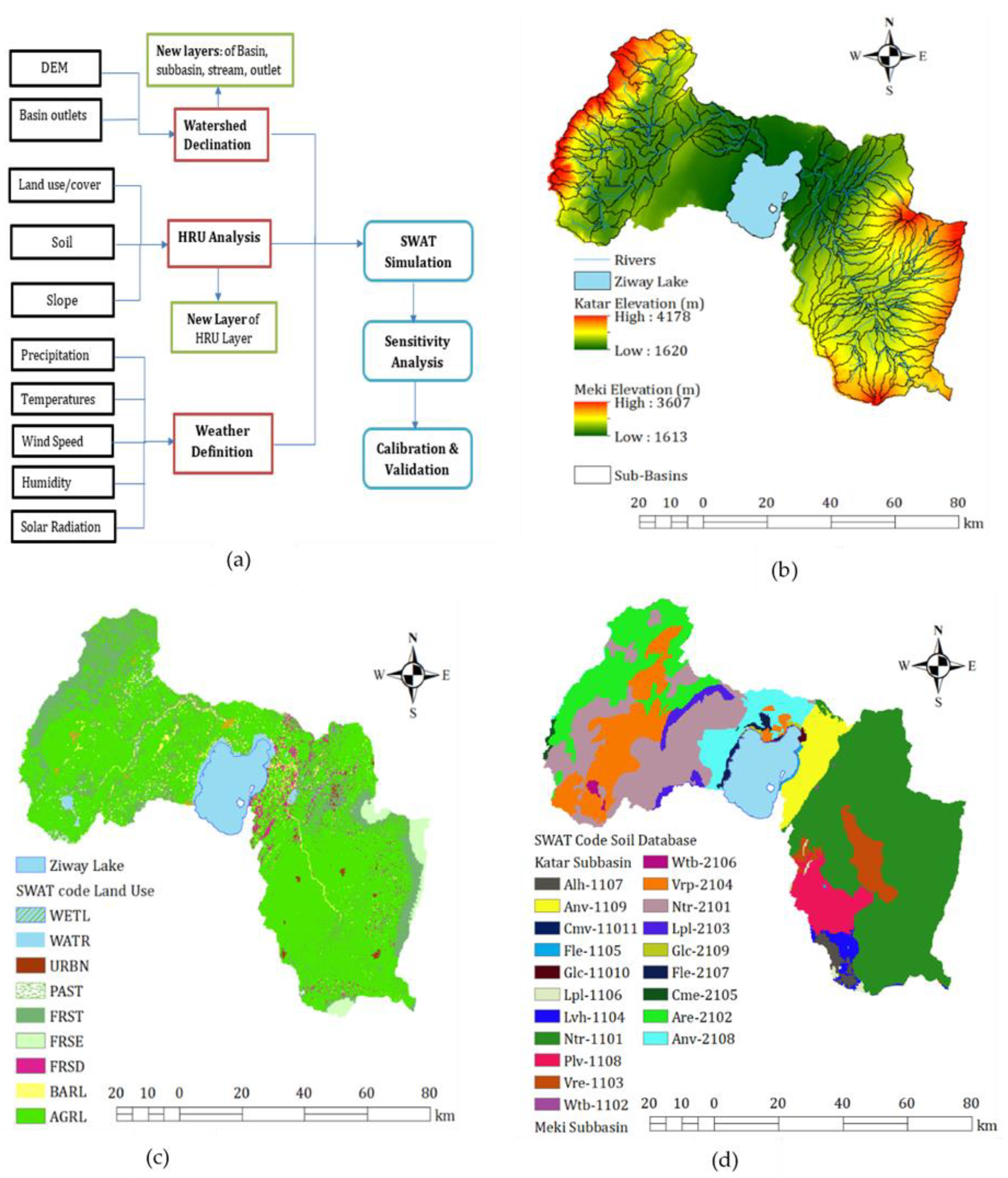
2. Materials and Methods

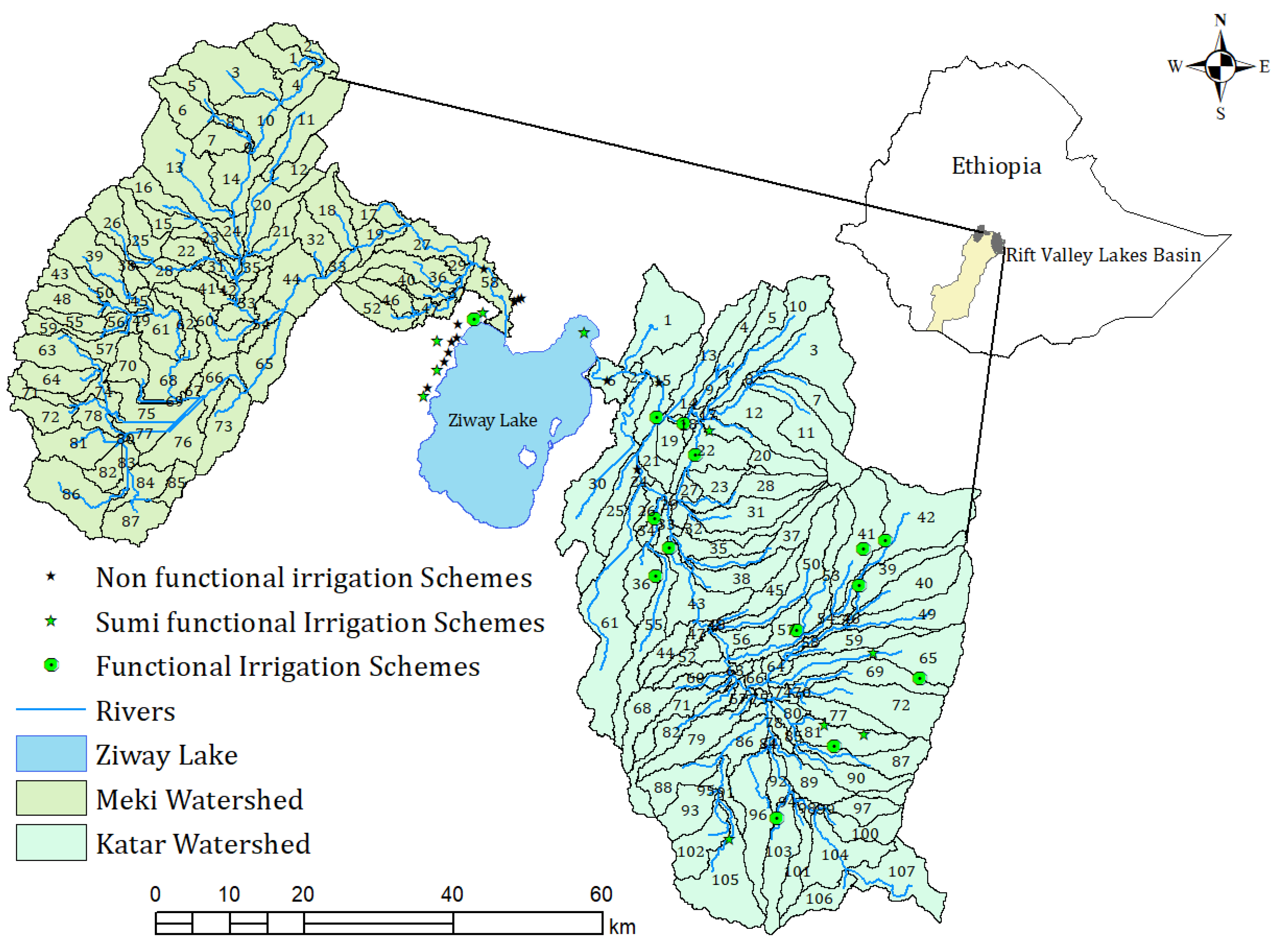
2.1. Description of the Study Area

The Central Rift Valley lakes basin is part of the Central Main Ethiopian Rift system (CMER) [20,21] and it is subdivided into four hydrologically interconnected lakes, namely Ziway, Langano, Shalla, and Abijata. Lake Ziway is the only freshwater among the rest of the lakes and it flows into Lake Abijata through the Bulbula River. Two river systems feed Lake Ziway, namely the Katar and Meki rivers. The Katar subbasin is geographically located between 38.88° and 39.41° E longitude and 7.36° and 8.18° N latitude, with an altitudinal range between 1630 and 4188 m a.m.s.l. Similarly, the Meki subbasin is situated between 38.22° and 39.00° E longitude and 7.83° and 8.46° N latitude, with an elevation range between 1686 and 3614 m a.m.s.l (Figure 1). The subbasins are subdivided into three topographic zones: the highland, the rift escarpment (midland), and the rift (lowland) floor [22]. The altitude ranges from 1600 m above mean sea level (a.m.s.l.) on the rift floor, where Lake Ziway is found, to 4118 a.m.s.l, where the Katar and Meki rivers originate. The average annual precipitation ranges from 749 to 1276 mm and 712 to 1150 mm, respectively, for the Katar and Meki subbasins. Average monthly minimum and maximum temperatures in the subbasins range between 13.4 and 14.2 °C and 27.5 and 28.7 °C, respectively, and between 24 and 27 °C and 27.5 and 30 °C in the highland areas. According to Ref. [23], rainfed agriculture accounts for 76.8% of the area, while irrigated agriculture accounts for less than 3%. Approximately 44% of the existing irrigated area is dependent on surface water abstracted rivers, 31% on Lake Ziway directly, and 25% on groundwater wells.

2.2. Hydrological Model Selection

Hydrologic simulation models have been widely used in recent years to address the challenge of a lack of observed data at the local level for water resource planning and utilization in the river basin [24]. Computer-based hydrological models are an excellent platform for understanding the hydrological processes in the watershed and for estimating or generating time-series data that may be difficult to measure directly in the field [24,25,26]. According to Refs. [27,28], models are simplified representations of the real world. Various hydrological models are developed to investigate the effects of climate changes, land use, and soil properties on hydrology and water resources [25,28]. They are classified into stochastic and deterministic as a function of space and time, lamped and distributed as a function of space [29], event-based and continuous, empirical models, conceptual models, and physically based models [28]. Each model has distinct characteristics and applications or purposes, including those for research, to enhance knowledge and understanding; some are used for simulation and prediction to support the planners and decision makers to take effective measures [28].
Among these models, the Soil and Water Assessment Tool (SWAT) [30] is one of the best hydrological models [31] that has the capability of modeling large-scale watersheds (>100 km2) with high performance, continuous-time simulation, and characterizing watersheds in great detail [32]. The SWAT model divides the catchments into many smaller subbasins and integrates different terrain data such as land use, soil characteristics, topography, precipitation, air temperature, and other physical parameters as inputs. The SWAT model is used in different parts of the world and over 4500 ISI publications are found using the SWAT model [32,33]. The SWAT model has also successfully been used in Ethiopia basins—the Upper Blue Nile basin [34,35,36,37], the Awash basin [38,39], and the Rift Valley lakes basin [40,41,42] to study the hydrology, erosion, and sediment transport process in the watershed.

2.3. SWAT Model Description

The Soil and Water Assessment Tool (SWAT) is a physically semi-distributed model that is computationally highly effective and capable of modeling continuous simulation over a long time [43]. The model was developed to predict the impact of land management practices on water, sediment, and agricultural chemicals in large and intricate watersheds with varying soils, land use, and management [44,45]. The SWAT model divides a given watershed into multiple sub-watersheds, which are then subdivided into further single Hydrologic Response Units (HRUs) of homogeneous land use or management, soil, and slope distributions [46,47]. The SWAT model incorporates various empirical and physical equations to calculate surface runoff, evapotranspiration, infiltration, percolation, and the flow of shallow and deep aquifers from each HRU that finally are routed through channels, ponds, and/or reservoirs and flow into a watershed outlet [44,45,46,47,48]. In general, the SWAT model is represented by the water balance Equation (1).
S W t = S W 0 + i = 1 t ( R d a y + Q s u r f E a W s e e p Q g w )  
where SWt is the final soil water content (mm H2O), SW0 is the initial soil water content on day i (mm H2O), t is the time (days), Rday is the amount of precipitation on day i (mm H2O), Qsurf is the amount of surface runoff on day i (mm H2O), Ea is the amount of evapotranspiration on day i (mm H2O), Wseep is the amount of water entering the vadose zone from the soil profile on day i (mm H2O), and Qgw is the amount of return flow on day i (mm H2O).

2.4. SWAT Model INPUT Parameters

2.4.1. Spatial Data

The Digital Elevation Model (DEM) is the spatial configuration of soil, including its physical and chemical properties, land use designations, and historical ground-based climate information of daily rainfall, temperature (maximum and minimum), solar radiation, relative humidity, and wind speed that are all-important inputs for the SWAT model setup. The Advanced Land Observing Satellite (ALOS) Phased Array L-Band Synthetic Aperture Radar (PALOSAR) Radiometrically Terrain-Corrected DEM with a pixel size of 12.5 m was downloaded from the ALOS website https://search.asf.alaska.edu on 15 July 2021 (Figure 2 Schematic workflow (a), digital elevation model (b), land use land cover (c), and soil type (d). Land use and soil data were obtained from the Water and Land Resource Center (WLRC) (Figure 2c,d); physical soil properties such as maximum soil depth (SOL ZMX), soil texture (% sand, %silt, and %clay), number of layers, and soil color (chroma, hue, and value) were retrieved from the Rift Valley Lakes Basin master plan soil report [49]. Other physical characteristics of the soil were estimated using the pedotransfer function. This function helps to translate data we have into data we need for hydrological modeling [50]. Soil albedo was estimated using Ref. [51] and organic carbon was estimated using Ref. [52]. Saturated hydraulic conductivity, available soil water content, and bulk density of the soil were estimated using SPAW (Soil, Plant, and Water relationship) software [53]. Finally, a specific soil database for the study areas was prepared and appended to the SWAT model user soil database.

2.4.2. Hydro-Climate Data

The Ethiopian National Meteorological Agency (NMA) provided daily precipitation and maximum and minimum temperatures for 16 stations from 1997 to 2014 (Table 1). The data were prescreened for outliers or incorrectly entered values, such as negative rainfall and minimum temperatures that were higher than maximum temperatures. For stations that did not have temperatures (maximum and minimum), the values of the nearest stations were used. Additionally, Climate Hazards Group Infrared Precipitation with Station (CHIRPS) was downloaded from http://climateserv.servirglobal.net/ website accessed on 13 April 2021 for the time between 1997 and 2014 [54]. The spatial correlation between observed and CHIRP datasets is greater than 0.8, which falls in the range of very good over most stations in the study regions and some studies have evaluated the quality of CHIRPS data over data scars areas and concluded that the quality is good [55,56,57].

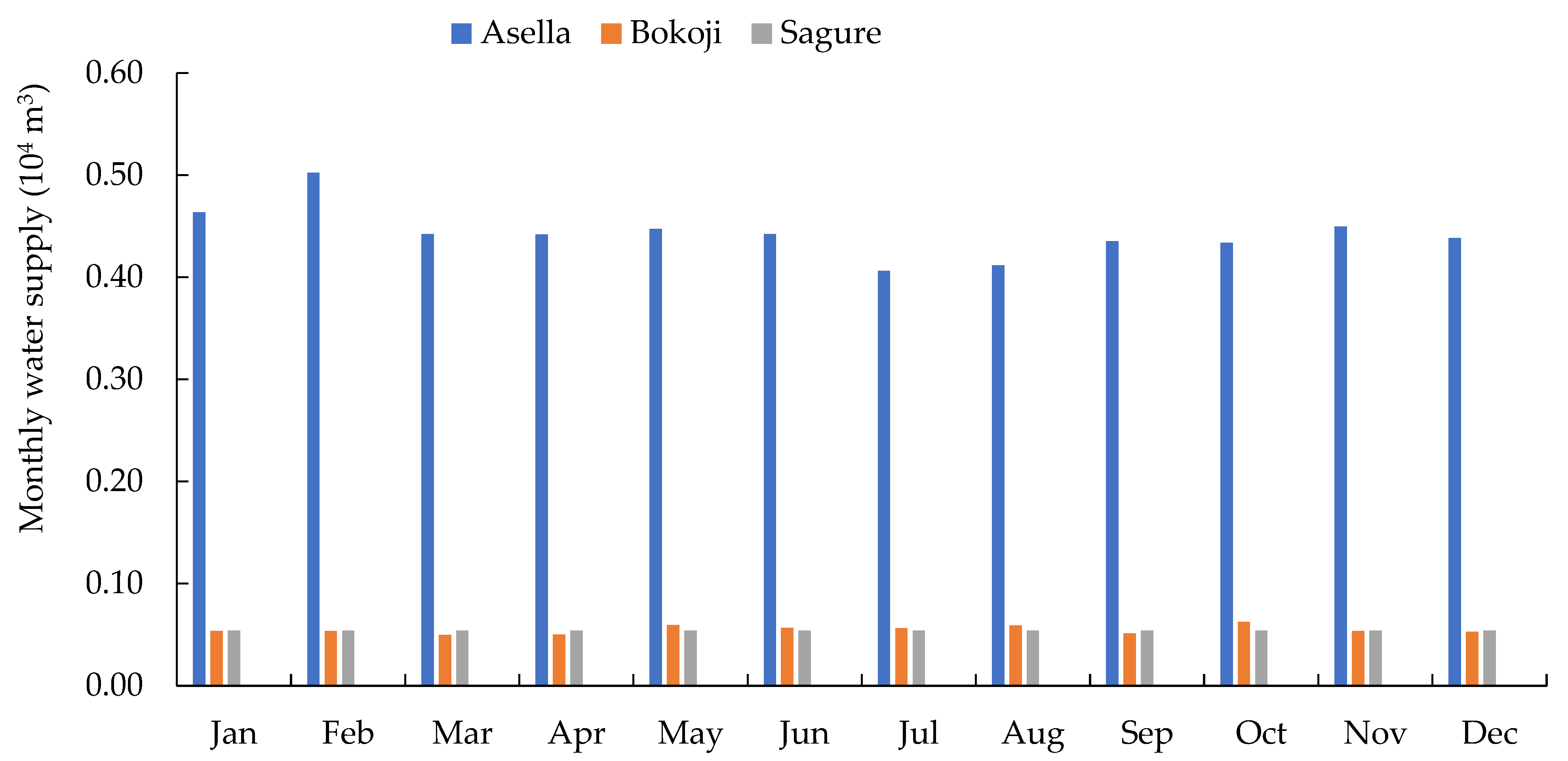
2.4.3. Consumptive Water Use

Irrigation and domestic water demands are the main water abstractions considered in this study. The monthly water supply of major towns such as Asella, Sagure, and Bokoji was collected from the respective water supply offices. Three rounds of field observation and formal discussions were held with farmers to identify field water management practices and irrigation methods, soil type, and the major crops grown. However, there is no information or any design document that shows how much water is diverted from the rich/rivers in all irrigation schemes. Crop and irrigation water requirements for each irrigation scheme were estimated using CRIWAR software, which is free of charge and can be downloaded from www.bos-water.nl accessed on 12 May 2022. CRIWAR uses three approaches to calculate potential evapotranspiration. The modified Hargreaves method was used to estimate actual evapotranspiration (ET), using data from the metrological stations nearest to the irrigation scheme [58,59]. If irrigation is the source of water supply to the plant, the amount of water is estimated by Equations (2) and (3) [59].
E T C = E T K C
I R n = E T C ( P e + G e + W b ) + L R  
where IRn is the net irrigation requirement in mm, Pe is effective dependable rainfall in mm, Ge is groundwater contribution from the water table in mm, Wb is soil water stored at the beginning of irrigation in mm, and LR is the leaching requirement in mm. The gross irrigation requirement (IRg) accounts for conveyance and application losses and is expressed in terms of efficiency (E) and calculated by Equation (4).
I R g = I R n E  

2.5. SWAT Model Parametrization, Calibration, and Uncertainty Analysis

2.5.1. Model Setup and Configuration

The Arc-SWAT model breaks the preprocessing systems into five steps: watershed delineation, Hydrologic Response Unit (HRU) and weather definition, SWAT run, and parametrization (including, sensitivity, calibration, validation, and uncertainty analysis) (Figure 2a). To understand how each section works within the modeling process, it is very important to understand the conceptual framework of each step, the input data types, the methods to prepare them, and how they are integrated into the model. Topographic characteristics (drainage network, slope length, inlet/outlet, and basin and subbasin areas) were produced from DEM (12.5 m grid size). Soil and land-use maps of the study areas and multiple slope classes were used to discretize the watersheds. One-third of the threshold area was adopted for minimum drainage size and a combination of 20% land use, 10% soil, and 10% slope was adopted to discretize multiple HRUs [34]. A standalone macro-excel program was downloaded from swat.tamu.edu accessed on 8 may 2022 to calculate the required weather statistical parameters and to append them to the SWAT model user weather database to calculate the missing values of climate variables.

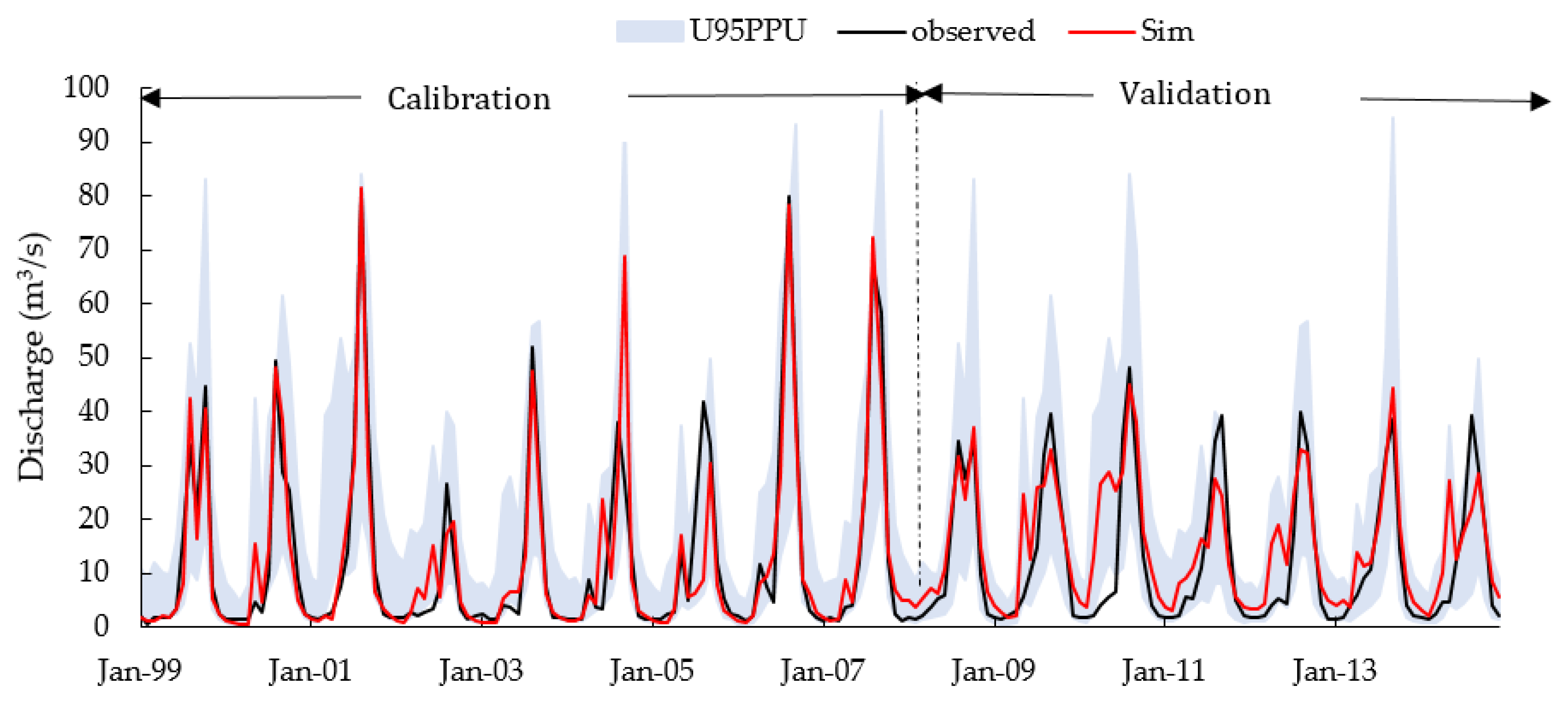
2.5.2. Model Parametrization, Calibration, and Uncertainty Analysis

In hydrological research, uncertainty is summarized into input data uncertainty, model uncertainty, and parameter uncertainty [27]. Any sources of uncertainty are a bottleneck to the accuracy of the hydrological model. Several studies have shown that the ability of hydrological models to produce satisfactory predictions is based on an adequate sensitivity analysis followed by model calibration and uncertainty analysis [60,61,62,63]. The Sequential Uncertainty Fitting Version 2 (SUFI-2) algorithm can map all uncertainties within the 95 Percent of Probability Uncertainty (95PPU) and is used for SWAT model calibration, validation, sensitivity, and uncertainty analysis [64,65]. The assessment of the relative change in model outputs as a consequence of relative changes in model inputs is known as a “sensitivity analysis of a parameter”. To establish the sensitivity of each parameter, global sensitivity analysis (all at once) uses the t-test and p-values. The sensitivity is measured by the t-stat (higher absolute values indicate more sensitivity) and the p-values determine the significance of the sensitivity. A p-value of around zero is more significant and this sort of sensitivity analysis may be done after iterations [66]. Calibration is the process of determining model parameter values by comparing the simulation result to observed or measured data under the same conditions [28].

2.5.3. Model Performance Evaluation

There are different statistical and graphical methods used to evaluate the model’s performance. The most widely used metrics to evaluate the performance of the hydrological model are the Coefficient of Determination (R2), the Nash–Sutcliffe Efficiency (NSE), the Percent Bias (PBIAS), and the Root Mean Square Error Standard Deviation Ratio (RSR) [28]; they are defined as follows.
The Nash–Sutcliffe Efficiency (NSE) is a normalized statistic that determines the relative magnitude of the residual variance (“noise”) compared with the measured data [28,60]. It shows how well it fits the plot of observed versus simulated datasets. The values of NSE range from zero to one, and the more the NSE value approaches one, the better the model performance and vice versa (look Table 2).
The Coefficient of Determination (R2) estimates the combined dispersion between observed and simulated data series [61]. The value ranges from zero to one. This means that a zero value means no correlation at all, whereas a value of one (1) means that the dispersion of the simulation is equal to that of the observation, and a representative value greater than 0.5 is considered acceptable (Table 2).
Percent Bias (PBIAS): This measures the average tendency of the simulated data to be larger or smaller than the observed values. PBIAS is expressed as a percentage. The lower the absolute value of PBIAS, the better the model performs (look in Table 2).
In addition to the above three metrics, the p-factor and the r-factor are used to determine the strength of model simulation and uncertainty assessment. The p-factor is the percentage of measured data bracketed by the 95PPU band and ranges from zero to one, with one indicating complete bracketing of measured data within model prediction uncertainty and zero indicating larger output uncertainty. The r-factor (1-p-factor) represents the observed data that the model could not adequately predict. In other words, the r-factor is the model error. As a result, the SUFI-2 algorithm tries to surround the majority of the observed data (high p-factor, maximum 100 percent) with the smallest possible r-factor value (minimum zero) [67].

3. Result and Discussion

3.1. Curent Irrigation and Urban Water Uses

Agriculture is the main water-use sector. The main purpose of irrigation is to supply the required amount of water to crops to avoid undesirable stress throughout the growing cycle [68]. For this study, 14 active irrigation schemes were identified (11 in Katar and 3 in the Meki subbasins) (Figure 1). Daily consumptive uses of major vegetables (potato, tomato, onion, and cabbage) were estimated by CRIWAR software from mid-December (sowing time) to the first ten days of June (harvesting time). A total volume of 17.4 million cubic meters (MCM) of water is diverted from the Katar and Meki rivers to irrigate 1733.9 hectares (Table 3). The area of each irrigation scheme was obtained from the inventory report performed by Ref. [69]. Similarly, long-term average monthly urban water consumption data were collected from the office of water supply and sewerage of the cities in the watersheds (Figure 3). Asella town is the largest consumer of water. Its sources are the Ashebeka River, which is a tributary of the Katar River. A total volume of 2.01 MCM of water is utilized for urban water consumption. This shows that 19.41 MCM of water is abstracted from the hydrology of the Katar and Meki rivers.

3.2. Subbasin Discretization and HRU Definition

The Katar and Meki watersheds are found in the eastern and western parts of Lake Ziway (Figure 1) and cover a total drainage area of 5573.4 km2 (3368.5 Katar and 2204.9 Meki subbasins). The subbasins were delineated using 12.5 m by 12.5 m DEM and the subbasins were subdivided into 107 and 87 micro-subbasins based on the one-third threshold as per the recommendation given by Ref. [34]. A multiple HRU definition option was selected to define the HRUs, which resulted in 683 and 658 HRUs for the Katar and Meki subbasins, respectively. Consequently, the computed runoff from each subbasin is routed through the Katar and Meki rivers’ network to the watershed outlets and finally the flow enters Lake Ziway.

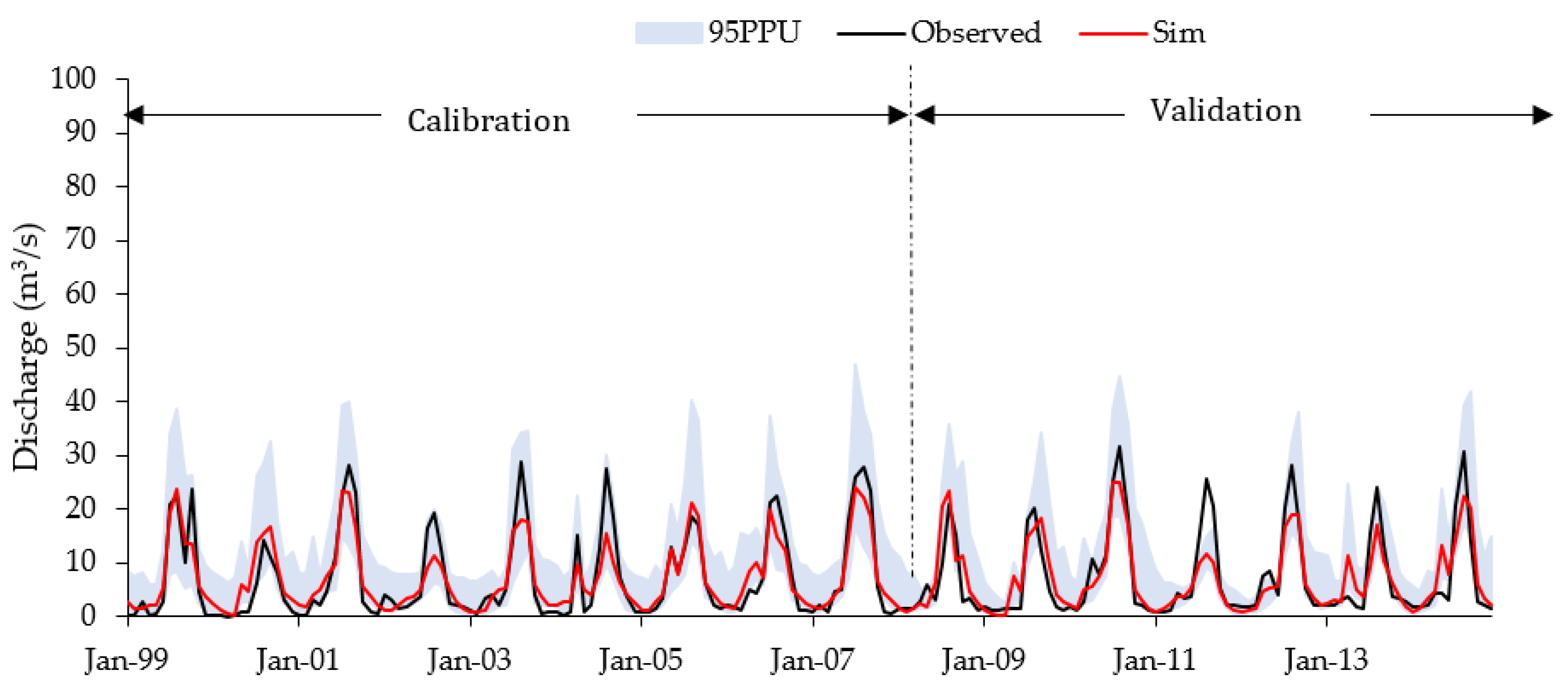
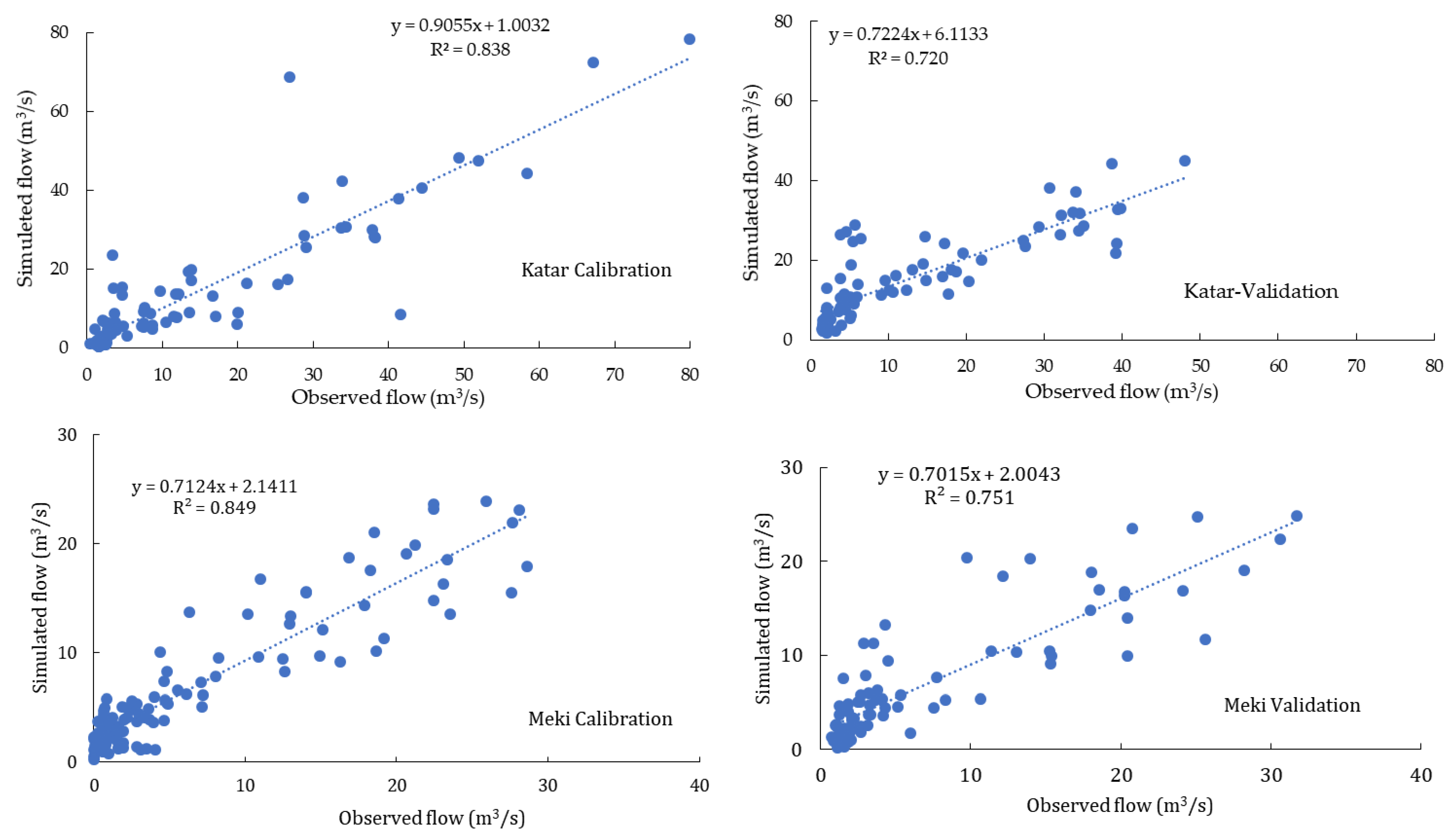
3.3. Sensitivity Analysis, Model Calibration, and Validation

The simulation covered a total period of eighteen (1997–2014) years. Two years (1997–1988) were used for model warm-up, nine years (1999–2007) for calibration, and seven years (2008–2014) for model validation. The algorithm of SUFI-2 is an iterative procedure that does not need more than four iterations. An auto-calibrate was initiated for sixteen flow parameters with 1500 simulations, which were divided into three with 500 simulations each. The relative sensitivity of the parameters was analyzed using the global sensitivity analysis of SWAT-CUP and the parameters were classified orderly from high (1st) to low (16th) based on the t-values (Table 4) and the most sensitive parameters were for the model calibration.

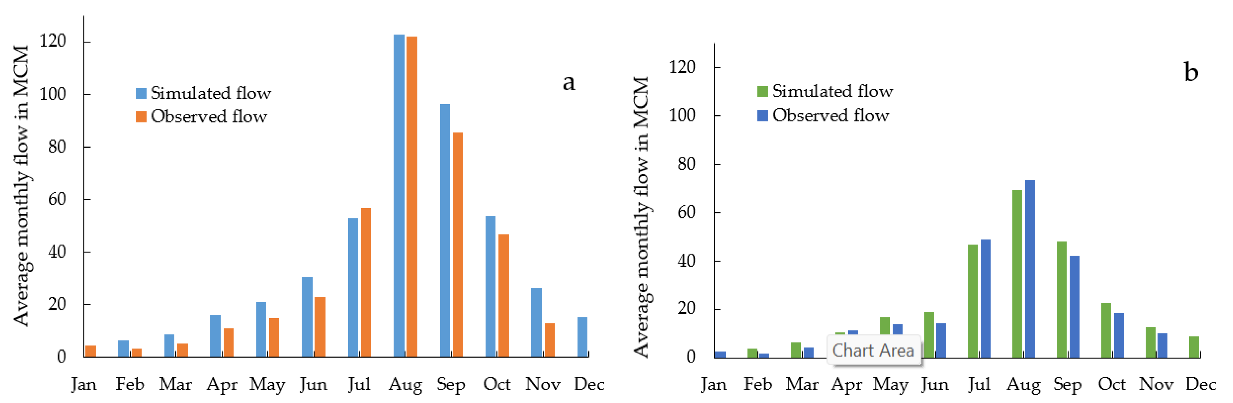
3.4. Model Performance

Figure 4 and Figure 5 show the hydrograph of stream flows (observed and simulated) for the calibration and validation period for the respective subbasin; the model’s metrics’ results are summarized in Table 5. The results were a good agreement with the requirements proposed for stream flow by Ref. [28]. The NSE and R2 were >0.65 during the calibration and validation period for the Katar subbasin, with resulting good results. For the Meki subbasin, the NSE and R2 values were >0.75 during the calibration and validation process, which resulted in very good results. The PBIAS values were <25%, which indicated a satisfactory result and the model underestimated the flow during the calibration and validation of the Katar subbasin. However, the PBIAS values for the Meki subbasin were <10 percent, which means that the estimated flow at the Meki subbasin was more than 65% of the simulated flow bracketed with the 95PPU for both subbasins, with the thickness of 95PPU ranging from 0.90 to 1.41 during the calibration and ranging from 1.15 to 1.31 during the validation processes. This showed that the results were well in agreement with the recommendation proposed by Ref. [62] for measuring the strength of the SWAT model calibration and validation within 95PPU.
Figure 6 depicts the coefficient of determination between observed and simulated data during the calibration and validation period. During the calibration, the coefficient of determination was >0.8 for the Katar and Meki subbasins. However, during the validation, the values were >0.7. R2 denotes the proportion of the variance in measured data that the model explains and its values range from zero to one. The higher values indicate less error variance and values greater than 0.5 are typically considered acceptable [28]. The model performance metrics agreed with the findings of Ref. [9], indicating that the SWAT model accurately described the hydrology of the Katar and Meki subbasins.

3.5. Hydrology of Katar and Meki Subbasins

The hydrology of the Katar and Meki subbasins can be investigated after running a SWAT error check for 1999 to 2014 for both subbasins and after determining the ratio of the water balance component summarized in Table 6. As a result, the ratio of precipitation to stream flow was 0.3 and the base flow to total flow was 0.49 for the Katar subbasin. This indicated that 51% of the runoff flow and base flow had a contribution of 49% of the total stream into Lake Ziway through the Katar subbasin. In addition, the ratio of precipitation to stream flow on the Meki subbasin was 0.29 and the base flow to total flow was found to be 0.61, which indicated 39% of runoff flowing into the Ziway, while 61% of the flow was the base flow contribution. The ratio of percolation to precipitation varied in the range between 0.17 and 0.2 and deep percolation to precipitation was negligible compared with other water balance components for both subbasins. However, the ratio of evapotranspiration (ET) to precipitation was 0.66 for the Katar subbasin and 0.72 for the Meki subbasin, which indicates that a significant amount of precipitation falling on the subbasins was lost in the form of ET. A similar finding was reported by Ref. [69] at the Katar and Meki subbasins.

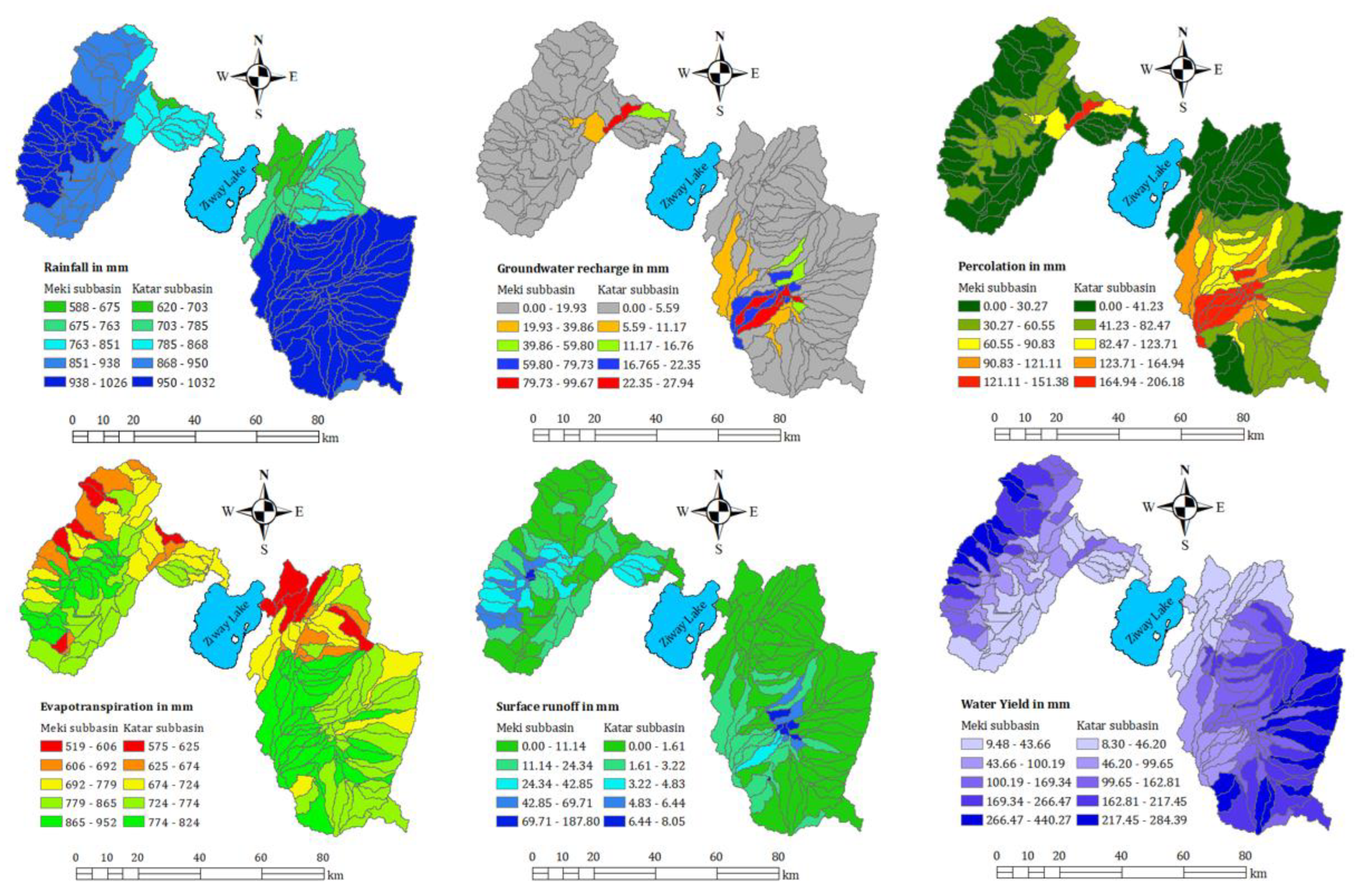
3.6. Spatial Variation of Water Balance Components

The most important water balance components considered in this study are rainfall (P), surface runoff (Qs), evapotranspiration (ET), groundwater discharge (Qgw), soil water (SW), and water yield (WYLD) (Figure 7). The average annual rainfall amount over Katar and Meki subbasins varied in the range between 620 and 1053 mm and 588 and 1026 mm, respectively. The distribution of rainfall amounts is directly associated with altitude, which means, at the highest altitude, the average annual rainfall amount varied in the range between 950 and 1053 mm in most parts of the Katar and Meki subbasins. An insignificant part of the Katar subbasin received an average annual rainfall ranging between 851 and 938 (Figure 7). However, in the Meki subbasin, the average annual rainfall varied in the range between 851 and 938 mm in most mid altitudes. At the low altitude near Lake Ziway, the average annual rainfall varied in the range between 620 and 868 mm (east of the lake) and 763 and 851 mm (west of the lake), respectively, for the Katar and Meki subbasins.
Furthermore, the average annual rate of ET at the subbasin scales varied in the range between 575 and 824 mm and 519 and 952 mm over the Katar and Meki subbasins, respectively. Similar to precipitation, the rate of ET was higher at the high altitude of the subbasins and gradually decreased along the low altitude (near Lake Ziway). Several factors influence the rate of ET, including the availability of moisture, the wind speed, and the type and size of vegetation cover [70]. Agriculture (intensive cultivation) and forest are the dominant land covers at high- and mid-altitudes of the two subbasins [71], where the rate of evapotranspiration is high.
The spatial distribution of annual surface runoff (Qs) varied in the range between 0 and 8 mm for Katar and 0 and 187 mm for the Meki subbasins (Figure 7). The highest surface runoff was generated in the highlands of the Meki subbasin. This might be due to the highest rainfall amount, steep slope, and watershed morphometric characteristics. Relatively, the Katar subbasin generated lower surface runoff than the Meki subbasin (Figure 7). This might be caused due to the difference in land-use type and vegetation and wetlands (Harabata wetland now it has been changed into a permanent lake and the Shetmata wetland) at the upstream of the Abura gauging station of the Katar subbasin. According to Ref. [72] the vegetation is primarily dominated by Afro-alpine at higher elevations (3276–4008 a.m.s.l), Erica (heath dominated) at middle elevations (3202–3985 a.m.s.l), dry evergreen Afromontane vegetation at elevations of 2843–3756 a.m.s.l, and mixed-species tree plantations at lower elevations (3181–3340 a.m.s.l) of the Katar subbasin. However, in the Meki subbasin, Enset is primarily the dominant vegetation type at the high altitude and non-Enset vegetation dominates at the mid and lower altitude [73]. The other important factor is the presence of rodent animals in Mount Chilalo, wherefrom most tributary rivers of Katar River originated [74]. These animals make flow conduits for groundwater recharge and percolation rather than surface runoff generation at high altitudes of high rainfall receiving areas. The morphology of tributary rivers and the watershed characteristics of the Katar subbasin also affect the surface water amount. This requires further study that includes investigating the impacts of wetland, geology, watershed morphometric characteristics, and the existing management of the watershed on the hydrologic components of both subbasins.
The spatial distribution of Qgw varied in the range between 0 and 27 mm at the Katar subbasin and 0 and 99 mm at the Meki subbasin. The spatial variation of groundwater recharge in the eastern and western highlands of the subbasins varied in the range between 0 and 5.59 and 19.93 in the Katar and Meki subbasins, respectively. The groundwater recharge potential is higher where the rift escarpment crosses the subbasins in the middle and southwestern parts of Katar and the Meki subbasins. The SWAT model has a drawback in estimating the spatial distribution of groundwater levels and recharge rates [75] that may require independent groundwater modeling and coupling with the surface water model (such as the SWAT model) to study the interaction. The contribution of the percolation rate to the water balance in the Katar subbasin is higher (varied in the range between 0 and 206 mm) than the Meki subbasin (varied in the range between 0 and 151 mm). Furthermore, water yield (WYLD) is the amount of water contributed to stream flow after all losses from the tributary channels in the HRU. The WYLD varied between 8 and 284 and 9 and 440 mm for the Katar and Meki subbasins, respectively. The spatial distribution of WYLD at the basin scale is shown in Figure 7, which indicates that the eastern and western highlands of the subbasins have the highest contribution of annual water yield. Furthermore, the results showed that the lowest contribution to the water yield came from the southwestern Katar and the southeastern Meki subbasins near Lake Ziway. Figure 7 illustrates the spatial distribution of the water balance component at the basin scale for the entire simulation period.

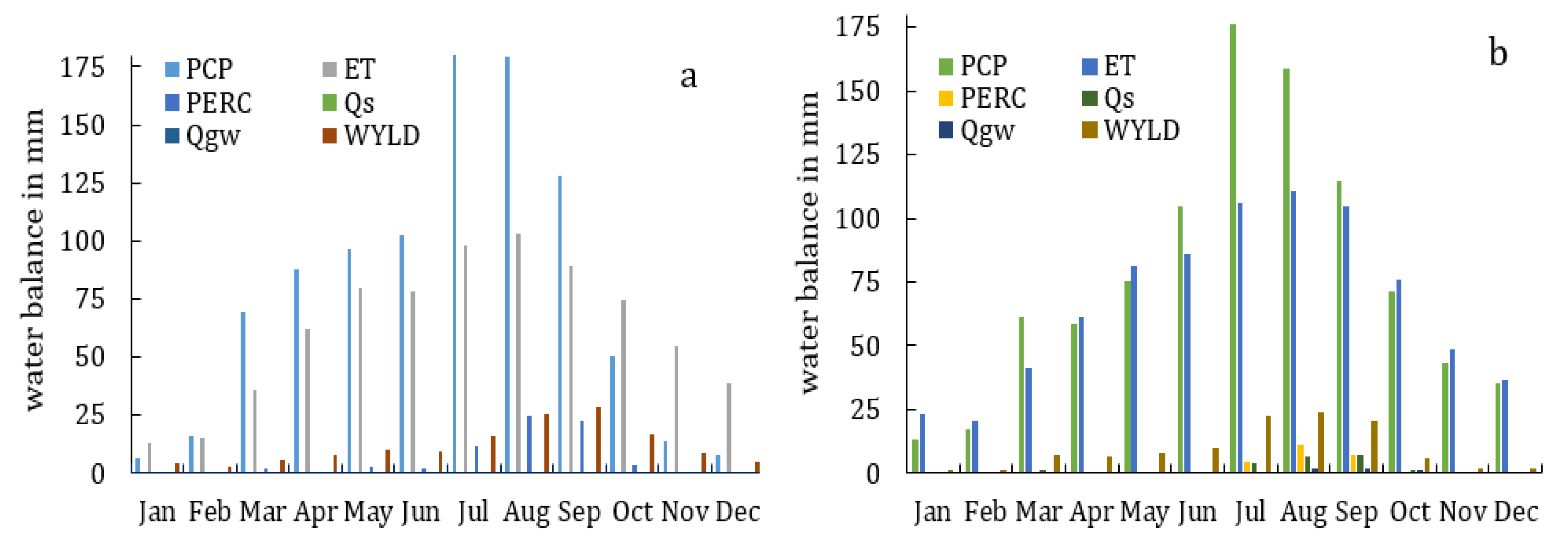
3.7. Temporal Variability of Water Balance

After model calibration and validation, annual, seasonal, and monthly water balance analyses were performed from 1999 to 2014; the summary of the results is given in (Figure 8). From March to September for the Katar subbasin and from April to September for the Meki subbasin, the water balance was positive, which indicates that rainfall exceeded the rate of evapotranspiration. Furthermore, the study has shown that from October to February, the rate of evapotranspiration exceeded the amount of rainfall and the water balance was negative. Table 7 illustrates the model estimate of the average annual water balance components of the Katar and Meki subbasins for the entire simulation period after model calibration. On the other hand, water yield was higher during the wet season in both subbasins following the rainfall amount.

3.8. Trends of Annual and Monthly Discharge of Katar and Meki Subbasins

Figure 9 displays the long-term average monthly observed and simulated flows of the Katar (a) and Meki (b) subbasins. Similar to rainfall, the monthly flow started to increase from June to September, which is the main rainy season of the subbasins. The dry season (low flow) started from December to March, which is the season during which irrigated agriculture started (see Section 3.1 of this work). The average annual estimated flow for the Katar and Meki subbasins is 455.48 (+16% overestimated) and 266.83 (+9.6% overestimated) MCM, respectively. Total annual flow during the wet season (June to September), the Katar subbasin contributed 302 MCM, which is 66.5% of the annual total flow, and the Meki subbasin contributed 205 MCM, which is 68% of the total flow. Furthermore, the study shows that during low flow seasons, such as winter (October to January) and spring (February to May), the Katar subbasin contributed 22.5% and 11% and the Meki subbasin contributed 17.6% and 14.6%, respectively.

3.9. Basin-Scale Availability of Surface Water Potential and Impacts of Increasing Water Demands

In Section 3.1, Table 3 and Figure 3 have been illustrated to show total irrigation water requirement and domestic water use. Furthermore, the surface water potential at the basin scale was assessed for an effective irrigation schedule and the result is displayed in Figure 10. As the results show, there was no deficit of surface water during the effective irrigation time in all schemes considered in this study. The total estimated irrigation water demand was 19.41 MCM, which accounts for 10% of the total flow of the winter and spring seasons. The current morphometric characteristics of Lake Ziway are estimated as an area that varies from 440 to 442.5 km2, a total volume of 1–1.64 billion meter cubes (BMC), and a depth of 2.5–3 m [76]. This ever-increasing water abstraction upstream of the watershed reduces the Lake Ziway level by 4.5 cm, dries up some of the tributary rivers upstream, and escalates the conflict between water users and damage to infrastructure at the Asella water supply every year (physical observation in January 2022). In comparison with the total flow of 722 MCM (455.48 and 266.83 MCM) into Lake Ziway and the future irrigation development plan of 14940 ha around Lake Ziway, the current water abstraction is insignificant [49]. However, studies have shown that any decrease in Lake Ziway’s water level caused by water abstraction would significantly reduce the downstream water level of Lake Abijata. [11,77]. This condition will worsen if current development trends continue and 14,940 ha of land is fully developed, requiring a total of 149.92 MCM for irrigation and significantly lowering the Lake Ziway level by 1.72 m, resulting in the lake’s capacity being lost. Previous research has shown the effects of water abstraction on lake environments [4,6,78]. However, a study was carried out by Ref. [11] on the impacts of direct water abstraction on Lake Ziway and its water level using three development pathways and concluded that Lake Ziway’s water level will decrease because of water resource development in feeding rivers as well as direct pumping from the lake. According to Ref. [2], land and water resources are inextricably linked in the CRV subbasins and any changes in land use will have an impact on the catchment’s hydrological system and available water resources. As a result, future plans should take this into account. For example, the provision of a motor pump each year to the farmers and the development plan and policy direction of dry-season irrigated agriculture to produce wheat intensify the water abstraction on each tributary and lake. The findings of this study show that water resource development will have a significant impact on lake water levels and ecosystem disruptions in the near future.

4. Conclusions

In this study, we evaluated the water balance component of the Katar and Meki subbasins of Lake Ziway using the SWAT hydrological model. The CHIRPS rainfall and observed temperature datasets were used to model setup and irrigation water requirements. Growth and net irrigation water requirements were calculated using CRIWAR software and domestic water data collected from the town municipality office. The SWAT model warmed up for two years (1997–1998), calibrated for nine years (1999–2007), and validated for seven years (2008–2014). Thus, to assess the impact of development interventions on Lake Ziway, this study combines the rainfall–runoff model and the water demand estimation model.
Our results indicate that in the performance SWAT model during calibration, the NSE ranged from 0.68 to 0.83, the R2 ranged from 0.73 to 0.85, and the PBIAS ranged from 1.6 to 17.5. Similarly, during the validation, NSE ranged from 0.67 to 0.75, R2 ranged from 0.72 to 0.75, and PBIAS ranged from 1.9 to 22.7. Furthermore, during the calibration process, the p-factor and the r-factor varied between 0.90 and 1.41. The spatial and temporal distribution of water balance components has been studied in the Katar and Meki subbasins. Annual estimated flows in the Katar and Meki subbasins are 455.48 MCM and 266.83 MCM, respectively. The water balance component of the Meki subbasin is superior to that of the Katar subbasin in many ways. During the wet season (June–September), the Katar subbasin contributes 302 MCM (66.5% of the annual flow), while the Meki subbasin contributes 205 MCM (68% of the annual flow).
Water abstraction for irrigation and domestic uses was estimated at 19.41 MCM from both subbasins, reducing the lake water level by 4.5 cm. This condition will worsen if current development trends continue and 14,940 ha of land is fully developed by irrigation, requiring a total of 149.92 MCM for irrigation and significantly lowering the Lake Ziway level by 1.723 m, resulting in the lake’s capacity being lost. Based on the findings of this study, we propose that future development plans should look for upstream–downstream linkage in order to limit the impacts of water abstraction on the lake level and its ecosystem services. To achieve sustainable water use in the lake environment, all concerned stakeholders must work cooperatively.

Author Contributions

All authors significantly contributed to the development of this manuscript. S.K.B. oversaw the conceptualization, data collection, software, data analysis, investigation, and preparation of the original draft. The manuscript was reviewed, edited, and improved by T.A.H. and G.T.A. The overall research work for this study was overseen by and G.T.A., A.A.A. and A.B. All authors have read and agreed to the published version of the manuscript.

Funding

This work was supported by the Water Security and Sustainable Development Hub, funded by the UK Research and Innovation’s Global Challenges Research Fund (GCRF) (grant number: ES/S008179/1). Gebiaw T. Ayele received funding from Griffith Graduate Research School, the Australian Rivers Institute and School of Engineering, Griffith University, Queensland, Australia.

Institutional Review Board Statement

Not applicable.

Informal Consent Statement

Not applicable.

Data Availability Statement

All datasets, raw or preprocessed, are available upon request from the corresponding author. Permission is required for observed data collected from Ethiopia’s National Meteorology Agency.

Acknowledgments

The authors would like to thank the Global Challenge Research Fund, the Ministry of Water and Energy (MoWE), the National Meteorological Service Agency (NMSA), the Rift Valley Lakes Basin Office, the town’s water supply offices (Asella, Bokoji, and Sagure), the Silte and Arsi (East and West) zones agriculture, and the natural resources offices for providing relevant data. Gebiaw T. Ayele acknowledges Griffith Graduate Research School, the Australian Rivers Institute and School of Engineering, Griffith University, Queensland, Australia.

Conflicts of Interest

The authors declare no conflict of interest.

References

  1. Huang, Y.; Cai, M. Methodologies Guidelines: Vulnerability Assessment of Freshwater Resources; United Nation Eviromental Program: Nairobi, Kenya, 2009. [Google Scholar]
  2. Jansen, H.; Hengsdijk, H.; Dagnachew, L.; Tenalem, A.; Hellegers, P.; Spliethoff, P. Land and Water Resources Assessment in the Ethiopian Central Rift Valley; Alterra-Rapport 1587; Alterra: Wageningen, The Netherlands, 2007; ISSN 1566-7197. [Google Scholar]
  3. Adeba, D.; Kansal, M.L.; Sen, S. Assessment of Water Scarcity and Its Impacts on Sustainable Development in Awash Basin, Ethiopia. Sustain. Water Resour. Manag. 2015, 1, 71–87. [Google Scholar] [CrossRef] [Green Version]
  4. Goshime, D.W.; Haile, A.T.; Rientjes, T.; Absi, R.; Ledésert, B.; Siegfried, T. Implications of Water Abstraction on the Interconnected Central Rift Valley Lakes Sub-Basin of Ethiopia Using WEAP. J. Hydrol. Reg. Stud. 2021, 38, 100969. [Google Scholar] [CrossRef]
  5. Ayenew, T.; Legesse, D. The Changing Face of the Ethiopian Rift Lakes and Their Environs: Call of the Time. Lakes Reserv. Res. Manag. 2007, 12, 149–165. [Google Scholar] [CrossRef]
  6. Desta, H.; Lemma, B.; Stellmacher, T.; Gebremariam, E. Water Use and Management of Lake Ziway and Its Watershed, Ethiopia: The Perception of Experts Vis-À-Vis the Latest State of Research. Environ. Dev. Sustain. 2019, 22, 3621–3640. [Google Scholar] [CrossRef]
  7. Zinabu, G.M.; Elizabeth, K.; Desta, Z. Long-Term Changes in Chemical Features of Waters of Seven Ethiopian Rift-Valley Lakes. Hydrobiologia 2002, 477, 81–91. [Google Scholar] [CrossRef]
  8. Meshesha, D.T.; Tsunekawa, A.; Tsubo, M. Continuing Land Degradation: Cause—Effect In Ethiopia’s Central Rift Valley. Land Degrad. Dev. 2012, 23, 130–143. [Google Scholar] [CrossRef]
  9. Hayal, D.; Brook, L. SWAT Based Hydrological Assessment and Characterization of Lake Ziway Sub-Watersheds, Ethiopia. J. Hydrol. Reg. Stud. 2017, 13, 122–137. [Google Scholar] [CrossRef]
  10. Pascual-Ferrer, J.; Pérez-Foguet, A.; Codony, J.; Raventós, E.; Candela, L. Assessment of Water Resources Management in the Ethiopian Central Rift Valley: Environmental Conservation And Poverty Reduction. Int. J. Water Resour. Dev. 2014, 30, 572–587. [Google Scholar] [CrossRef]
  11. Goshime, D.W.; Haile, A.T.; Absi, R.; Ledésert, B. Impact of Water Resource Development Plan on Water Abstraction and Water Balance of Lake Ziway, Ethiopia. Sustain. Water Resour. Manag. 2021, 7, 17. [Google Scholar] [CrossRef]
  12. Lemma, B. Ecological Changes in Two Ethiopian Lakes Cuased by Contrasting Human Intervation. Limnologica 2003, 53, 44–53. [Google Scholar] [CrossRef]
  13. Alemayehu, T.; Furi, W.; Legesse, D. Impact of Water Overexploitation on Highland Lakes of Eastern Ethiopia. Environ. Geol. 2007, 52, 147–154. [Google Scholar] [CrossRef]
  14. Seyoum, W.M.; Milewski, A.M.; Durham, M.C. Understanding the Relative Impacts of Natural Processes and Human Activities On The Hydrology Of The Central Rift Valley Lakes, East Africa. Hydrol. Process. 2015, 29, 4312–4324. [Google Scholar] [CrossRef]
  15. Alemayehu, T.; Mccartney, M.; Kebede, S. The Water Resource Implications of Planned Development in the Lake Tana Catchment, Ethiopia. Ecohydrol. Hydrobiol. 2010, 10, 211–221. [Google Scholar] [CrossRef]
  16. Assefa, D. Causes And Effects Of Diminishing Water Volume in Lake Chelekleka, Bishoftu, Ethiopia and Strategy for Conservation; Addis Ababa University: Addis Ababa, Ethiopia, 2015. [Google Scholar]
  17. Lorenz, D.L.; Ziegeweid, J.R. Methods to Estimate Historical Daily Streamflow for Ungaged Stream Locations in Minnesota; U.S. Geological Survey Scientific Investigations Report 2015–5181; US Geological Survey: Reston, VA, USA, 2015; p. 18. [CrossRef]
  18. Aliye, M.A.; Aga, A.O.; Tadesse, T.; Yohannes, P. Evaluating the Performance of HEC-HMS and SWAT Hydrological Models in Simulating the Rainfall-Runoff Process for Data Scarce Region of Ethiopian Rift Valley Lake Basin. Open J. Mod. Hydrol. 2020, 10, 105–122. [Google Scholar] [CrossRef]
  19. Chimdesa, G. Climate Change Impacts and Adaptation Actions in Central Rift Valley of ethiopia. J. Nat. Sci. Res. 2016, 6, 84–93. [Google Scholar]
  20. Bonetto, S.M.R.; Caselle, C.; De Luca, D.A.; Lasagna, M. Groundwater Resources In The Main Ethiopian Rift Valley: An Overview For A Sustainable Development. Sustain. 2021, 13, 1347. [Google Scholar] [CrossRef]
  21. Martínek, K.; Verner, K.; Hroch, T.; Megerssa, L.A.; Kopačková, V.; Buriánek, D.; Muluneh, A.; Kalinová, R.; Yakob, M.; Kassa, M. Main Ethiopian Rift Landslides Formed in Contrasting Geological Settings and Climatic Conditions. Nat. Hazards Earth Syst. Sci. 2021, 21, 3465–3487. [Google Scholar] [CrossRef]
  22. Ayenew, T. Numerical Groundwater Flow Modeling of the Central Min Ethiopian Rift Lakes Basin. SINET Ethiop. J. Sci 2001, 24, 167–184. [Google Scholar]
  23. Taye, A.H.; Sisay, K.; Biniyam, Y.; Amare, B.; Adey, N. Review: Groundwater Research in the Ethiopian Rift Valley Lakes Region. Frontiers 2022, 1–18. [Google Scholar]
  24. Devia, G.K.; Ganasri, B.P.; Dwarakish, G.S. A Review on Hydrological Models. Aquat. Procedia 2015, 4, 1001–1007. [Google Scholar] [CrossRef]
  25. Wagener, T.; Wheater, H.S.; Gupta, H.V. Rainfall-Runoff Modelling in Guaged And Ungauged Catchmnets; Imperial College Press: Londan, UK, 2004; ISBN 1860944663. [Google Scholar]
  26. Hosseini, M.; Amin, M.S.M.; Ghafouri, A.M.; Tabatabaei, M.R. Application of Soil and Water Assessment Tools Model for Runoff Estimation. Am. J. Appl. Sci. 2011, 8, 486–494. [Google Scholar] [CrossRef] [Green Version]
  27. Abbaspour, K.C.; Rouholahnejad, E.; Vaghefi, S.; Srinivasan, R.; Yang, H.; Kløve, B. A Continental-Scale Hydrology and Water Quality Model For Europe: Calibration and Uncertainty of A High-Resolution Large-Scale SWAT Model. J. Hydrol. 2015, 524, 733–752. [Google Scholar] [CrossRef]
  28. Moriasi, D.N.; Arnold, J.G.; Van Liew, M.W.; Bingner, R.L.; Harmel, R.D.; Veith, T.L. Model Evaluation Guidline For Systematic Quantification of Accuracy in Wateshed Simulations. Am. Soc. Agric. Biol. Eng. 2007, 50, 885–900. [Google Scholar]
  29. Sorooshian, S.; Hsu, K.-L.; Coppola, E.; Tomassetti, B.; Verdecchia, M.; Visconti, G. General Review of Rainfall-Runoff Modeling: Model Calibration, Data Assimilation and Uncertianity Analysis. In Hydrological Modelling And The Water Cycle: Coupling The Atmospheric And Hydrological Models; Sorooshian, S., Hsu, K.-L., Coppola, E., Tomassetti, B., Verdecchia, V., Visconti, G., Eds.; Springer Science and Business Media B.V.: New York, NY, USA, 2008; pp. 1–24. ISBN 9783540778424. [Google Scholar]
  30. Arnold, J.G.; Srinivasan, R.; Muttiah, R.S.; Williams, J.R. Large Area Hydrologic Modeling and Assessment Part I: Model Development. J. Am. Water Resour. Assoc. 1998, 34, 73–89. [Google Scholar] [CrossRef]
  31. Al-Khafaji, M.S.; Al-Sweiti, F.H. Integrated Impact of Digital Elevation Model and Land Cover Resolutions On Simulated Runoff By SWAT Model. Hydrol. Earth Syst. Sci. 2017, 653, 1–26. [Google Scholar]
  32. Kannan, N.; White, S.; Worrall, F.; Whelan, M. Sensitivity Analysis and Identification of The Best Evapotranspiration And Runoff Options For Hydrological Modelling In SWAT-2000. J. Hydrol. 2007, 332, 456–466. [Google Scholar] [CrossRef]
  33. Tuo, Y.; Duan, Z.; Disse, M.; Chiogna, G. Science of The Total Environment Evaluation of Precipitation Input for SWAT Modeling in Alpine Catchment: A Case Study in the Adige River Basin (Italy). Sci. Total Environ. 2016, 573, 66–82. [Google Scholar] [CrossRef] [Green Version]
  34. Setegn, S.G.; Srinivasan, R.; Dargahi, B. Hydrological Modelling in The Lake Tana Basin, Ethiopia Using SWAT Model. Open Hydrol. J. 2008, 2, 49–62. [Google Scholar] [CrossRef] [Green Version]
  35. Galata, A.W.; Tullu, K.T.; Guder, A.C. Evaluating Watershed Hydrological Responses to Climate Changes at Hangar Watershed, Ethiopia. J. Water Clim. Chang. 2021, 12, 2271–2287. [Google Scholar] [CrossRef]
  36. Dile, Y.; Ayana, E.K.; Tekleab, S.; Gebrehiwot, S.G. Advances In Water Resources Research in the Upper Blue Nile Basin and the Way Forward: A Review. J. Hydrol. 2018, 560, 407–423. [Google Scholar] [CrossRef]
  37. Chakilu, G.G.; Sándor, S.; Zoltán, T.; Phinzi, K. Climate Change and the Response of Streamflow of Watersheds under the High Emission Scenario in Lake Tana Sub-Basin, Upper Blue Nile Basin, Ethiopia. J. Hydrol. Reg. Stud. 2022, 42, 101175. [Google Scholar] [CrossRef]
  38. Tolera, M.B.; Chung, I.M. Integrated Hydrological Analysis of Little Akaki Watershed Using SWAT-MODFLOW. Appl. Sci. 2021, 11, 6011. [Google Scholar] [CrossRef]
  39. Jilo, N.B.; Gebremariam, B.; Harka, A.E.; Woldemariam, G.W.; Behulu, F. Evaluation of The Impacts of Climate Change on Sediment Yield From the Logiya Watershed, Lower Awash Basin, Ethiopia. Hydrology 2019, 6, 25. [Google Scholar] [CrossRef] [Green Version]
  40. Belihu, M.; Tekleab, S.; Abate, B.; Bewket, W. Hydrologic Response to Land Use Land Cover Change in the Upper Gidabo Watershed, Rift Valley Lakes Basin, Ethiopia. Hydroresearch 2020, 3, 85–94. [Google Scholar] [CrossRef]
  41. Aga, A.O.; Chane, B.; Melesse, A.M. Soil Erosion Modelling and Risk Assessment in Data Scarce Rift Valley Lake Regions, Ethiopia. Water 2018, 10, 1684. [Google Scholar] [CrossRef] [Green Version]
  42. Serur, A.B.; Adi, K.A. Multi-Site Calibration of Hydrological Model and The Response of Water Balance Components to Land Use Land Cover Change in A Rift Valley Lake Basin In Ethiopia. Sci. Afr. 2022, 15, e01093. [Google Scholar] [CrossRef]
  43. Arnold, J.G.; Moriasi, D.N.; Gassman, P.W.; Abbaspour, K.C.; White, M.J.; Srinivasan, R.; Santhi, C.; Harmel, R.D.; Van Griensven, A.; Van Liew, M.W.; et al. Swat: Model Use, Calibration and Validation. Am. Soc. Agric. Biol. Eng. 2012, 55, 1491–1508. [Google Scholar]
  44. Neitsch, S.L.; Arnold, J.G.; Kiniry, J.R.; Williams, J.R. Soil & Water Assessment Tool Theoretical Documentation Version 2009; Texas Water Resources Institute Technical Report No. 406; Texas A&M University System: College Station, TX, USA, 2011. [Google Scholar]
  45. Zhang, D.; Chen, X.; Yao, H.; Lin, B. Improved Calibration Scheme of SWAT By Separating Wet and Dry Seasons. Ecol. Modell. 2015, 301, 54–61. [Google Scholar] [CrossRef] [Green Version]
  46. Gassman, P.P.W.; Reyes, M.M.R.; Green, C.C.H.; Arnold, J.J.G. The Soil and Water Assessment Tool: Historical Development, Applications, and Future Research Directions. Am. Soc. Agric. Biol. Eng. 2010, 50, 1211–1250. [Google Scholar] [CrossRef] [Green Version]
  47. Ayele, G.T.; Teshale, E.Z.; Yu, B.; Rutherfurd, I.D.; Jeong, J. Streamflow and sediment yield prediction for watershed prioritization in the Upper Blue Nile River Basin, Ethiopia. Water 2017, 9, 782. [Google Scholar] [CrossRef] [Green Version]
  48. Arnold, J.G.; Kiniry, J.R.; Srinivasan, R.; Williams, J.R.; Haney, E.B.; Neitsch, S.L. Soil and Water Assessment Tool “SWAT” Input/Output Documentation Version 2012; Texas Water Resources Institute: College Station, TX, USA, 2012; ISBN 978-0-387-30858-6.
  49. Halcrow, Rift Valley Lakes Basin Integrated Resources Development Master Plan Project Report Soils and Land Evaluation; Ministry of Water Resource (Mowr)—The Federal Democratic Republic Of Ethiopia: Addis Ababa, Ethiopia, 2007.
  50. Abbaspour, K.C.; Vaghefi, S.A.; Yang, H.; Srinivasan, R. Global Soil, Landuse, Evapotranspiration, Historical and Future Weather Databases for SWAT Applications. Sci. Data 2019, 6, 263. [Google Scholar] [CrossRef] [PubMed] [Green Version]
  51. Wang, K.; Wang, P.; Liu, J.; Sparrow, M.; Haginoya, S.; Zhou, X. Variation of Surface Albedo and Soil Thermal Parameters with Soil Moisture Content at a Semi-Desert Site on the Western Tibetan Plateau. Bound.-Layer Meteorol. 2005, 116, 117–129. [Google Scholar] [CrossRef]
  52. Post, W.M.; Kwon, K.C. Soil Carbon Sequestration and Land-Use Change: Processes and Potential. Glob. Chang. Biol. 2000, 6, 317–327. [Google Scholar] [CrossRef] [Green Version]
  53. Saxton, K.E.; Rawls, W.J. Soil Water Characteristic Estimates by Texture and Organic Matter for Hydrologic Solutions. Soil Sci. Soc. Am. J. 2006, 70, 1569–1578. [Google Scholar] [CrossRef] [Green Version]
  54. Funk, C.; Peterson, P.; Landsfeld, M.; Pedreros, D.; Verdin, J.; Shukla, S.; Husak, G.; Rowland, J.; Harrison, L.; Hoell, A.; et al. The Climate Hazards Infrared Precipitation With Stations—A New Environmental Record For Monitoring Extremes. Sci. Data 2015, 2, 150066. [Google Scholar] [CrossRef]
  55. Nogueira, S.M.C.; Moreira, M.A.; Volpato, M.M.L. Evaluating Precipitation Estimates From Eta, TRMM and CHRIPS Data in the South-Southeast Region Of Minas Gerais State-Brazil. Remote Sens. 2018, 10, 16. [Google Scholar] [CrossRef] [Green Version]
  56. Belay, A.S.; Fenta, A.A.; Yenehun, A.; Nigate, F.; Tilahun, S.A.; Moges, M.M.; Dessie, M.; Adgo, E.; Nyssen, J.; Chen, M.; et al. Evaluation and Application Of Multi-Source Satellite Rainfall Product CHIRPS To Assess Spatio-Temporal Rainfall Variability on Data-Sparse Western Margins of Ethiopian Highlands. Remote Sens. 2019, 11, 2688. [Google Scholar] [CrossRef] [Green Version]
  57. Geleta, C.D.; Deressa, T.A. Evaluation of Climate Hazards Group Infrared Precipitation Station (CHIRPS) Satellite-Based Rainfall Estimates over Finchaa And Neshe Watersheds, Ethiopia. Eng. Rep. 2021, 3, e12338. [Google Scholar] [CrossRef]
  58. Allen, R.G.; Pereira, L.S.; Raes, D.; Smith, M. Crop Evapotranspiration (Guidline for Computing Crop Water Requirements); Water Resources, Development and Management Service–FAO: Rome, Italy, 1998; Volume 56. [Google Scholar]
  59. Savva, A.P.; Frenken, K. Crop Water Requirements And Irrigation Scheduling. Irrigation Manual Module 4; FAO: Rome, Italy, 2002. [Google Scholar]
  60. Nash, J.E.; Sutcliffe, J. V River Flow Forcasting Throgh Conceptual Models Part I A Discussion Of Principles. J. Hydrol. 1970, 10, 282–290. [Google Scholar] [CrossRef]
  61. Krause, P.; Boyle, D.P.; Bäse, F. Advances in Geosciences Comparison of Different Efficiency Criteria for Hydrological Model Assessment. Adv. Geosci. 2005, 5, 89–97. [Google Scholar] [CrossRef] [Green Version]
  62. Abbaspour, K.C.; Vaghefi, S.A.; Srinivasan, R. A Guideline for Successful Calibration and Uncertainty Analysis for Soil and Water Assessment: A Review of Papers from the 2016 International SWAT Conference. Water 2018, 10, 6. [Google Scholar] [CrossRef] [Green Version]
  63. Gourbesville, P.; Caignaert, G. Advances in Hydroinformatics SIMHYDRO 2012—New Frontiers of Simulation; Springer: Singapore, 2012; ISBN 9789814451413. [Google Scholar]
  64. Abbaspour, K.C. SWATCUP-2019 SWAT Calibration and Uncertainty Programs; Eawag, Swiss Federal Institute Of Aquatic Science And Technology: Dübendorf, Switzerland, 2019; p. 100. [Google Scholar]
  65. Song, X.; Zhang, J.; Zhan, C.; Xuan, Y.; Ye, M.; Xu, C. Global Sensitivity Analysis in Hydrological Modeling: Review of Concepts, Methods, Theoretical Framework, And Applications. J. Hydrol. 2015, 523, 739–757. [Google Scholar] [CrossRef] [Green Version]
  66. Khalid, K.; Ali, M.F.; Rahman, N.F.A.; Mispan, M.R.; Haron, S.H.; Othman, Z.; Bachok, M.F. Sensitivity Analysis in Watershed Model Using SUFI-2 Algorithm. Procedia Eng. 2016, 162, 441–447. [Google Scholar] [CrossRef] [Green Version]
  67. Abbaspour, K.C.; Yang, J.; Maximov, I.; Siber, R.; Bogner, K.; Mieleitner, J.; Zobrist, J. Modelling Hydrology and Water Quality in the Pre-Alpine/Alpine Thur Watershed Using SWAT. J. Hydrol. 2007, 333, 413–430. [Google Scholar] [CrossRef]
  68. Bos, M.G.; Keslik, R.A.L.; Allen, R.G.; Molden, D. Water Requirments for Irrigation and the Enviroment; Springer: Dordrecht, Switzerland, 2009; ISBN 978-1-4020-8947-3. [Google Scholar]
  69. Oromia Irrigation Potential Assessment Project List of Identified Scheme Inventary Report; OWWDSE: Addis Ababa, Ethiopia, 2018.
  70. Ashaolu, E.D.; Iroye, K.A. Rainfall and Potential Evapotranspiration Patterns and Their Effects on Climatic Water Balance in the Western Lithoral Hydrological Zone of Nigeria. Ruhuna J. Sci. 2018, 9, 92. [Google Scholar] [CrossRef]
  71. Abraham, T.; Nadew, B. impact Of Land Use Land Cover Dynamics on Water Balance, Lake Ziway Hydrology: Current Research Impact of Land Use Land Cover Dynamics on Water Balance, Lake Ziway. Hydrol. Curr. Res. 2018, 9, 2. [Google Scholar] [CrossRef]
  72. Girma, Z.; Chuyong, G.; Evangelista, P.; Mamo, Y. Vascular Plant Species Composition, Relative Abundance, Distribution, and Threats in Arsi Mountains National Park, Ethiopia. Mt. Res. Dev. 2018, 38, 143–152. [Google Scholar] [CrossRef] [Green Version]
  73. Woldesenbet, A.B.; Wudmatas, S.D.; Denboba, M.A.; Gebremariam, A.G. Enset-Based Land Use Land Cover Change Detection and Its Impact on Soil Erosion In Meki River Watershed, Western Lake Ziway Sub-Basin, Central Rift Valley Of Ethiopia. Environ. Syst. Res. 2020, 9, 37. [Google Scholar] [CrossRef]
  74. Kasso, M.; Bekele, A. Seasonal Population Dynamics of Rodents of Mount Chilalo, Arsi, Ethiopia. SINET Ethiop. J. Sci. 2011, 34, 123–132. [Google Scholar]
  75. Kim, N.W.; Chung, I.M.; Won, Y.S.; Arnold, J.G. Development and Application of the Integrated SWAT—MODFLOW Model. J. Hydrol. 2008, 356, 1–16. [Google Scholar] [CrossRef]
  76. Strategic Plan For IWRM Ziway-Shalla Subbasin; Rift Valley Lakes Basin Office (RVLBO): Addis Ababa, Ethiopia, 2021.
  77. Vallet-Coulomb, C.; Legesse, D.; Gasse, F.; Travi, Y.; Chernet, T. Lake Evaporation Estimates in Tropical Africa (Lake Ziway, Ethiopia). J. Hydrol. 2001, 245, 1–18. [Google Scholar] [CrossRef]
  78. Goshime, D.W.; Absi, R.; Ledésert, B.; Dufour, F.; Haile, A.T. Impact of Water Abstraction on The Water Level of Lake Ziway, Ethiopia. Water Soc. 2019, 67, 67–78. [Google Scholar] [CrossRef]
Figure 1. Location map of the study area and irrigation schemes.
Water 14 03929 g001
Figure 2. Schematic workflow (a), digital elevation model (b), land use land cover (c), and soil type (d).
Water 14 03929 g002
Figure 3. The average domestic water supply of Asella, Bokoji, and Sagure towns (104 M3/day).
Water 14 03929 g003
Figure 4. Stream flow calibration and validation result of Katar subbasin at Abura station (1999–2014).
Water 14 03929 g004
Figure 5. Stream flow calibration and validation result of Meki subbasin near Meki Village station (1999–2014).
Water 14 03929 g005
Figure 6. Monthly correlation of observed and simulated flow during calibration and validation of Katar and Meki subbasins.
Water 14 03929 g006
Figure 7. Spatial variation of water balance components in Katar and Meki subbasins (1999–2014).
Water 14 03929 g007
Figure 8. Temporal variation of water balance (mm) components in Katar (a) and Meki (b) from 1999 to 2014.
Water 14 03929 g008
Figure 9. Monthly long-term average flow of observed vs. simulated Katar (a) and Meki (b) subbasins.
Water 14 03929 g009
Figure 10. Irrigation water demand (orange color) and surface water potential (blue color) at the basin scale of where an irrigation system is developed in 104 cubic meters.
Water 14 03929 g010
Table 1. Weather stations and summary of climate average rainfall (μRF) (mm).
SubbasinsStation NameLatitude (0)Longitude (0)μRFVariables
KatarArata7.9739.05766.46RF, Temp.
Asella7.9539.131053.98RF, Temp.
Dagaga7.4338.841049.89RF, Temp.
Iteya8.1339.331044.65RF, Temp.
Katar Genet7.8339.10801.38RF, Temp.
Kulumsa8.0039.15812.18RF, Temp.
Ogolcho8.0539.00710.68RF, Temp.
Sagure7.7539.15772.68RF, Temp.
MekiAdami Tulu7.8638.70854.70RF, Temp.
Alem Tena8.2938.91840.14RF, Temp.
Bui8.3338.55973.24RF, Temp.
Butajera8.1538.371010.76RF, Temp.
Ejerse Lele8.2438.69862.13RF, Temp.
Koshe8.0138.53760.19RF, Temp.
Meki8.1538.82742.82RF, Temp.
Ziway7.9338.70743.92RF, Temp.
Table 2. Classification of statistical model performance indices.
NSEBIASR2Classification
N S E = i n ( Q m Q s ) 2 i n ( Q m Q m ¯ ) 2 p b i a s = 100 i n ( Q o Q s ) i n Q o R 2 = [ i n ( Q m Q m ¯ ) ( Q s Q s ¯ ) ] 2 i n ( Q m Q m ¯ ) 2 ( Q s Q s ¯ ) 2
0.75 < ENS ≤ 1.00 PBIAS ≤ ±10 0.75 < R2 ≤ 1.00 Very good
0.60 < ENS ≤ 0.75 ±10 < PBIAS ≤ ±15 0.60 < R2 ≤ 0.75 Good
0.36 < ENS ≤ 0.60 ±15 < PBIAS ≤ ±25 0.50 < R2 ≤ 0.60 Satisfactory
0.00 < ENS ≤ 0.36 ±25 < PBIAS ≤ ±50 0.25 < R2 ≤ 0.50 Unsatisfactory
ENS ≤ 0.00 ±50 ≤ PBIAS R2 ≤ 0.25 Inappropriate
Table 3. Average daily water abstraction for irrigation in 10−2 MCB estimated using CRIWAR 3.0 software www.bos-water.nl accessed on 12 May 2022 based on the climate, crop characteristics, and general information of each irrigation site.
Irrigation
Names
SWAT
Subbasins
Area
(ha)
Irrigation Schedule
DecJanFebMarAprMayJun
1Gusha Timela57150.007.1324.4340.6840.9225.5010.390.00
2Katar 1, 2, and 343602.7128.6197.99163.3164.2103.042.720.87
3Arata Chufa18100.004.7416.2427.0827.2517.106.940.00
4Bosha 1 and 222168.287.9727.3145.5645.8528.7711.660.00
5Shelled13170.688.5628.4347.4347.0636.0617.480.50
6Sotira Katar103133.136.3921.8936.3436.3922.719.150.00
7Chemeri8740.001.926.5410.8610.916.842.760.00
8Tita Waji6997.542.4215.0724.4225.9517.467.911.12
9Jewara4238.001.836.2610.3910.396.482.600.00
10Digelu Bora3951.512.458.3713.9714.048.823.570.00
11Amrach4152.572.488.5314.2214.328.973.630.00
12Dodicha5869.003.2911.2218.7018.8211.794.900.09
13Teso Megertu1955.002.608.9314.9014.979.393.910.09
14Melka Kofe235.500.250.901.481.490.930.400.00
Total1733.980.63282.1469.3472.6303.8128.02.67
Table 4. Sensitivity analysis of SWAT parameters for Katar and Meki subbasins.
SWAT Model
Parameter
Katar SubbasinMeki Subbasin
t-StatRankFitted Valuet-StatRankFitted Value
ALPHA_BF.gw6.66610.4702.23080.147
CN2.mgt5.1762−0.11312.8972−0.057
SOL_AWC (…).sol4.64730.84913.6510.534
GWQMN.gw3.3684998.7794.6434833.568
ESCO.hru2.50550.6404.38150.079
GW_REVAP.gw1.82060.1101.033110.031
CH_K2.rte1.62876.5723.089617.307
SURLAG.bsn1.43886.6740.003160.183
CH_N2.rte1.23890.2370.251140.100
RCHRG_DP.gw1.089100.2781.18290.022
SOL_K (…).sol0.987110.8650.594120.000
GW_DELAY.gw0.94512448.5170.0521537.685
OV_N.hru0.7171318.6052.61872.586
EPCO.hru0.607140.83811.5230.358
SLSUBBSN.hru0.510150.0721.097100.001
REVAPMN.gw0.43516399.4810.4961335.457
Table 5. SWAT model performance evaluation for Meki and Katar subbasins.
Performance
Measuring Metrics
Katar SubbasinMeki Subbasin
CalibrationValidationCalibrationValidation
NSE0.680.670.830.75
R20.730.720.850.75
PBIAS−17.5−22.7−1.6−1.9
P-factor 0.810.920.670.69
R-factor 0.901.311.411.15
Table 6. Water balance ratio of Katar and Meki subbasins.
Rations Katar SubbasinMeki Subbasin
Stream flow/precipitation0.30.29
Base flow/total flow0.490.51
Surface runoff/total flow0.510.49
Percolation/precipitation0.170.10
Deep recharge/precipitation0.010.01
ET/precipitation 0.600.67
Table 7. Average annual water balance components of Katar and Meki subbasin (mm).
NamePCPETPERCQsQgwWYLDChange
Katar subbasin939.36743.4570.971.694.03140.00+23.78
Meki subbasin929.11796.0925.3623.266.08111.14+33.82
Publisher’s Note: MDPI stays neutral with regard to jurisdictional claims in published maps and institutional affiliations.

