
Watershed-Scale Shallow Groundwater Anthropogenic Nitrate Source, Loading, and Contamination Assessment in a Typical Wheat Production Region: Case Study in Yiluo River Watershed, Middle of China

Abstract
:1. Introduction
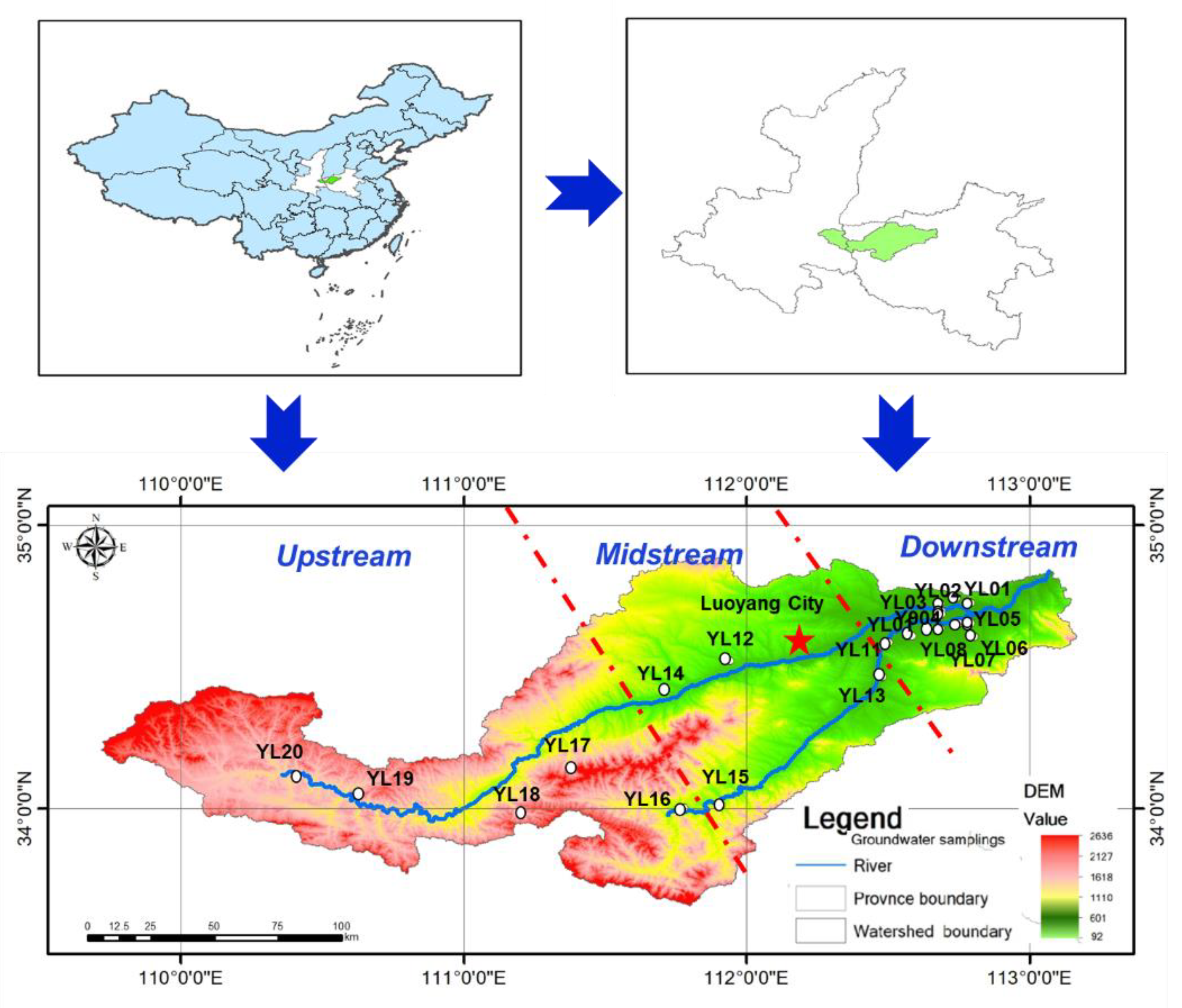
2. Study Area
3. Methodology
3.1. Water Sampling Collection
3.2. Field Measurements and Laboratory Analysis
3.3. Data Analysis
3.3.1. Total Nitrogen Loading
3.3.2. Nitrate Pollution Assessment
4. Results and Discussion
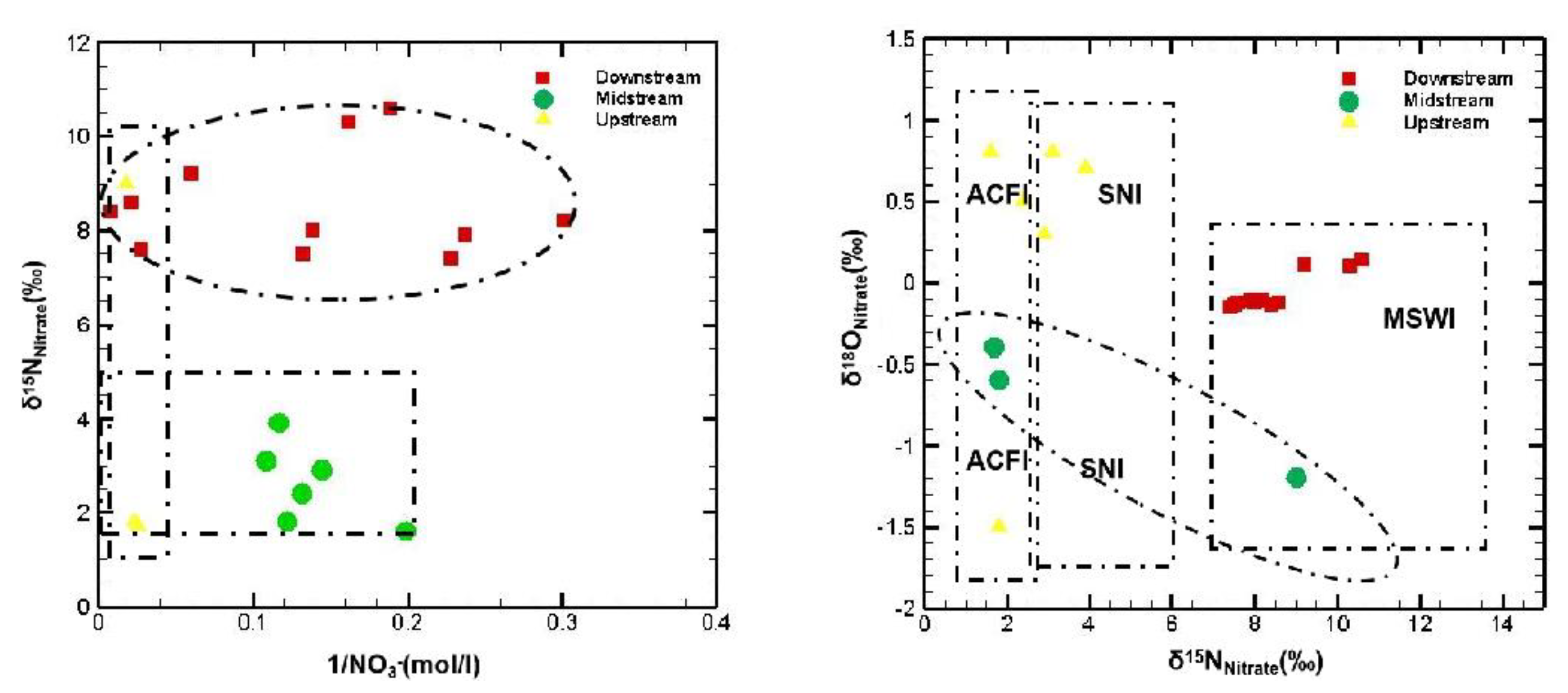
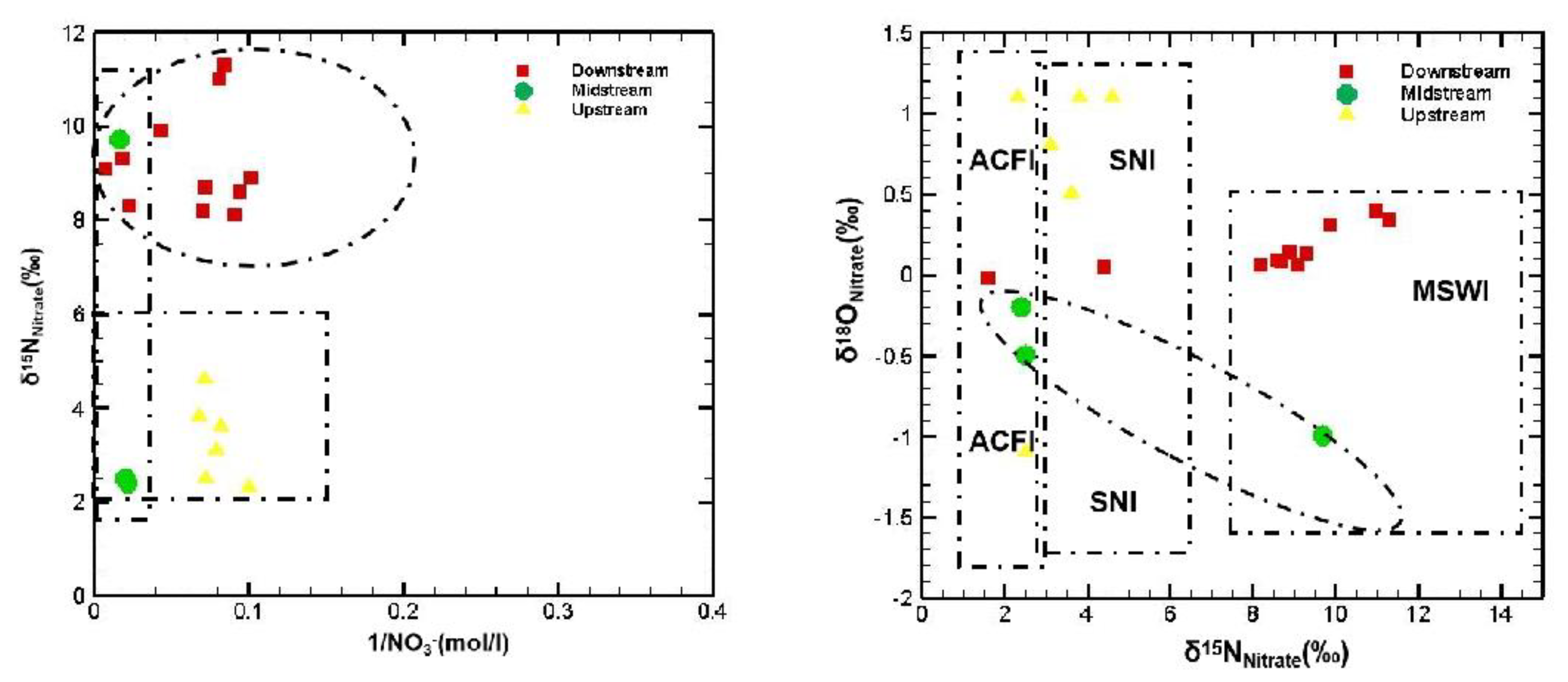
4.1. Nitrogen Pollution Sources and Tracing of Groundwater in the Yiluo River Watershed
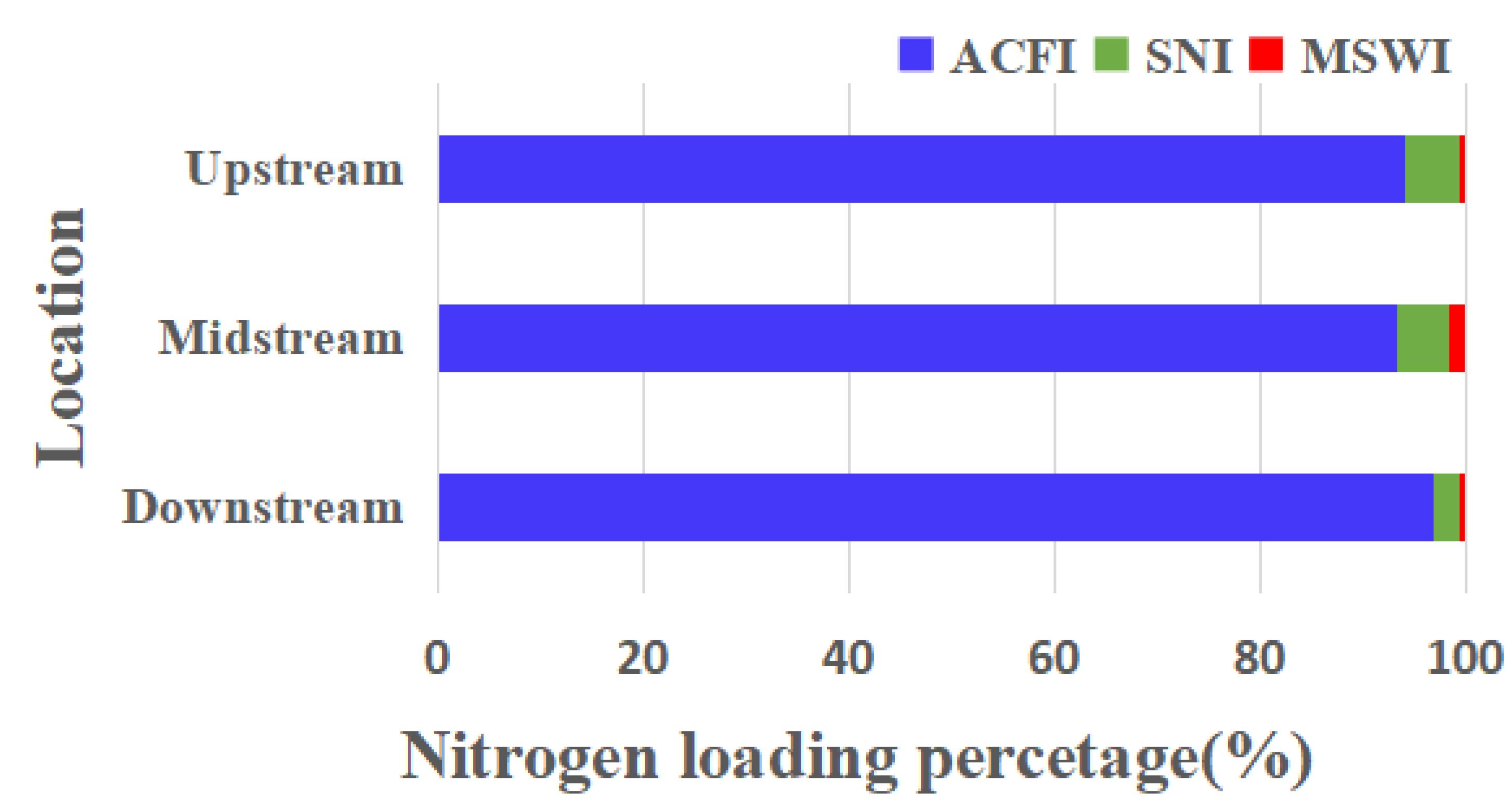
4.2. Groundwater Nitrogen Loading of the Yiluo River Watershed
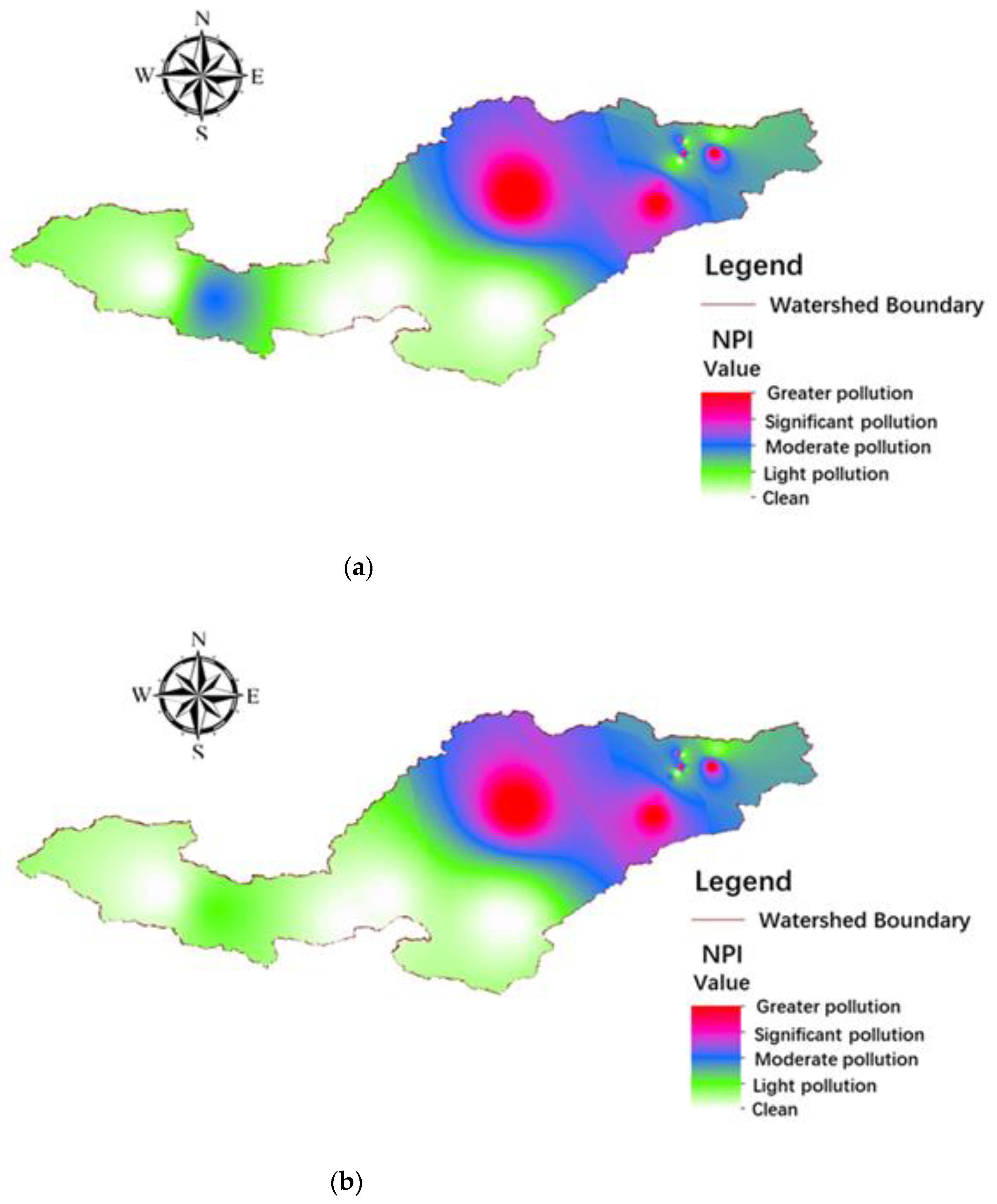
4.3. Nitrite Contamination Assessment of Groundwater in the Yiluo River Watershed
5. Conclusions
Author Contributions
Funding
Institutional Review Board Statement
Informed Consent Statement
Data Availability Statement
Acknowledgments
Conflicts of Interest
References
- Colombani, N.; Salemi, E.; Mastrocicco, M.; Castaldelli, G. Groundwater nitrogen speciation in intensively cultivated lowland areas. In Advances in the Research of Aquatic Environment; Springer: Berlin/Heidelberg, Germany, 2011; pp. 291–298. [Google Scholar]
- Voudouris, K.; Mandrali, P.; Kazakis, N. Preventing groundwater pollution using vulnerability and risk mapping: The case of the Florina Basin, NW Greece. Geosciences 2018, 8, 129. [Google Scholar] [CrossRef] [Green Version]
- Corcoran, S. Nitrate pollution and nitrogen isotope compositions in the Bazile groundwater management area-a water quality study. Creighton, NE. Bachelor’s Thesis, University of Nebraska-Lincoln, Lincoln, NE, USA, 2019. [Google Scholar]
- Wang, X.; Xu, Y.J.; Zhang, L. Watershed scale spatiotemporal nitrogen transport and source tracing using dual isotopes among surface water, sediments and groundwater in the Yiluo River Watershed, Middle of China. Sci. Total Environ. 2022, 833, 155180. [Google Scholar] [CrossRef] [PubMed]
- Somura, H.; Goto, A.; Mizutani, M. Modeling analysis of nitrate nitrogen pollution processes of groundwater in Nasunogahara Basin. Trans. -Jpn. Socirty Irrig. Drain. Reclam. Eng. 2003, 71, 1–10. [Google Scholar]
- Voronin, L.M.; Cauller, S.J. Simulated Groundwater Flow Paths, Travel Time, and Advective Transport of Nitrogen in the Kirkwood-Cohansey Aquifer System. Barnegat Bay–Little Egg Harbor Watershed, New Jersey; US Geological Survey Scientific Investigations Report; US Geological Survey: Reston, VA, USA, 2016.
- Hansen, B.; Thorling, L.; Schullehner, J.; Termansen, M.; Dalgaard, T. Groundwater nitrate response to sustainable nitrogen management. Sci. Rep. 2017, 7, 1–12. [Google Scholar] [CrossRef] [PubMed] [Green Version]
- Ransom, K.M.; Bell, A.M.; Barber, Q.E.; Kourakos, G.; Harter, T. A Bayesian approach to infer nitrogen loading rates from crop and land-use types surrounding private wells in the Central Valley, California. Hydrol. Earth Syst. Sci. 2018, 2, 2739–2758. [Google Scholar] [CrossRef] [Green Version]
- Lee, C.M.; Hamm, S.Y.; Cheong, J.Y.; Kim, K.; Yoon, H.; Kim, M.; Kim, J. Contribution of nitrate-nitrogen concentration in groundwater to stream water in an agricultural head watershed. Environ. Res. 2020, 184, 109313. [Google Scholar]
- Mitsch, W.J.; Day, J.W.; Gilliam, J.W.; Groffman, P.M.; Hey, D.L.; Randall, G.W.; Wang, N. Reducing Nitrogen Loading to the Gulf of Mexico from the Mississippi River Basin: Strategies to Counter a Persistent Ecological Problem: Ecotechnology—The use of natural ecosystems to solve environmental problems—Should be a part of efforts to shrink the zone of hypoxia in the Gulf of Mexico. BioScience 2001, 51, 373–388. [Google Scholar]
- Lloyd, S.; Mollod, G.; LoBlue, C.; Lindberg, M. Modeling nitrogen source loads on the north shore of Long Island. Nat. Conserv. 2016, 3, 1–32. [Google Scholar]
- Young, C.; Tamborski, J.; Bokuniewicz, H. Embayment scale assessment of submarine groundwater discharge nutrient loading and associated land use. Estuar. Coast. Shelf Sci. 2015, 15, 20–30. [Google Scholar]
- Kovač, Z.; Nakić, Z.; Špoljarić, D.; Stanek, D.; Bačani, A. Estimation of nitrate trends in the groundwater of the Zagreb aquifer. Geosciences 2018, 8, 159. [Google Scholar] [CrossRef] [Green Version]
- Sbarbati, C.; Colombani, N.; Mastrocicco, M.; Petitta, M.; Aravena, R. Reactive and mixing processes governing ammonium and nitrate coexistence in a polluted coastal aquifer. Geosciences 2018, 8, 210. [Google Scholar] [CrossRef] [Green Version]
- Zhang, D.; Yang, J.M.; Huang, X.Y.; Liu, S.T.; Zhang, Z.Y. Sources of dissolved heavy metals in river water of the Yiluo River basin based on sulfur isotope of sulfate. China Environ. Sci. 2019, 39, 2549–2559. [Google Scholar]
- Qi, R.S. The main characteristics and genetic analysis of the rainstorm in The Yiluo River basin. J. Henan Norm. Univ. Nat. Sci. Ed. 1983, 1, 43–49. [Google Scholar]
- Du, F. Impact of Landuse on the Hydrology Effective in the Yiluo River Watershed; University of Hehai Publication: Nanjing, China, 2007. [Google Scholar]
- Li, Z.J.; Zhang, P.; Li, X.; Wu, Y.T. The impact of changes of the climate and underlying surface in Yellow River regions on runoff. Am. Water Work. Assoc. 2009, 10, 558–563. [Google Scholar]
- Li, S.; Liu, W.; Gu, S.; Cheng, X.; Xu, Z.; Zhang, Q. Spatio-temporal dynamics of nutrients in the upper Han River basin, China. J. Hazard. Mater. 2009, 162, 1340–1346. [Google Scholar] [CrossRef] [PubMed]
- Liu, S.T.; Zhang, D.; Li, Y.H.; Yang, J.M. Water Sources and Factors Controlling on Hydro-chemical Compositions in the Yiluo River Basin. Environ. Sci. 2020, 41, 1184–1196. [Google Scholar]
- Zhao, S.D.; Kong, D.Z.; Huang, J.W.; Gao, Y. Study on Regional Water Resources Utilization and Ecological Environment Water Demand. Hydroelectr. Sci. Technol. 2019, 2, 49–51. [Google Scholar]
- He, R.M.; Wang, G.Q.; Zhang, J.Y. Impacts of Environmental Change on Runoff in the Yiluo River Basin of the Middle Yellow River. Res. Soil Water Conserv. 2017, 14, 280–297. [Google Scholar]
- Łapiński, D.; Wiater, J.; Szatyłowicz, E. The Content of Heavy Metals in Waste as an Indicator Determining the Possibilities of Their Agricultural Use. J. Ecol. Eng. 2019, 20, 225–230. [Google Scholar] [CrossRef]
- Szatyłowicz, E.; Krasowska, M. Assessment of heavy metals leaching from fly ashes as an indicator of their agricultural use. Desalination Water Treat. 2020, 199, 288–296. [Google Scholar] [CrossRef]
- Zhang, S.K.; Cheng, W.X.; Xu, X.L.; Yang, Y.X. Analysis of water pollution causes and prevention and control measures in Yilu River. Yellow River 2014, 36, 76–79. [Google Scholar]
- Skoczko, I.; Piekutin, J.; Szatyłowicz, E.; Niedźwiecka, M. Removal of boron from groundwater by filtration through selected filter bed materials. Rocz. Ochr. Środowiska 2016, 18, 861–872. [Google Scholar]
- Szatyłowicz, E.; Skoczko, I. Studies on the efficiency of groundwater treatment process with adsorption on activated alumina. J. Ecol. Eng. 2017, 18, 211–218. [Google Scholar] [CrossRef]
- Zhang, D.; Yang, W.; Zhao, J. Tracing nitrate sources of the Yellow River and its tributaries with nitrogen isotope. J. Ecol. Rural Environ. 2012, 28, 622–627. [Google Scholar]
- Mclver, R. Quantifying nitrogen loading and corresponding eutrophication symptoms in 7 bays in eastern New Brunswick, Canada. Master’s Thesis, Dalhousie University, Halifax, NS, Canada, 2015. [Google Scholar]
- Nagel, E.J.; Murphy, G.; Wong, M.C.; Lotze, H.K. Nitrogen Loading Rates for Twenty-One Seagrass Inhabited Bays in Nova Scotia, Canada; Department of Fisheries and Oceans: Nova Scotia, Canada, 2018; p. 37.
- Galloway, J.N.; Dentener, F.J.; Capone, D.G.; Boyer, E.W.; Howarth, R.W.; Seitzinger, S.P. Nitrogen cycles: Past, present, and future. Biogeochemistry 2004, 70, 153–226. [Google Scholar] [CrossRef]
- Zhang, J.; Xu, J.; Tan, X.; Zhang, Q. Nitrogen loadings affect trophic structure in stream food webs on the Tibetan Plateau, China. Sci. Total Environ. 2022, 844, 157018. [Google Scholar] [CrossRef] [PubMed]
- Panneerselvam, B.; Karuppannan, S.; Muniraj, K. Evaluation of drinking and irrigation suitability of groundwater with special emphasizing the health risk posed by nitrate contamination using nitrate pollution index (NPI) and human health risk assessment (HHRA). Hum. Ecol. Risk Assess. 2020, 27, 1324–1348. [Google Scholar] [CrossRef]
- Ogrinc, N.; Tamše, S.; Zavadlav, S.; Vrzel, J.; Jin, L. Evaluation of geochemical processes and nitrate pollution sources at the Ljubljansko polje aquifer (Slovenia): A stable isotope perspective. Sci. Total Environ. 2019, 646, 1588–1600. [Google Scholar] [CrossRef]
- Zhang, Y.; Li, F.; Zhang, Q.; Li, J.; Liu, Q. Tracing nitrate pollution sources and transformation in surface-and ground-waters using environmental isotopes. Sci. Total Environ. 2014, 490, 213–222. [Google Scholar] [CrossRef]
- Chen, J.; Taniguchi, M.; Liu, G.; Miyaoka, K.; Onodera, S.I.; Tokunaga, T.; Fukushima, Y. Nitrate pollution of groundwater in the Yellow River delta, China. Hydrogeol. J. 2007, 15, 1605–1614. [Google Scholar] [CrossRef]
- Hobbie, S.E.; Finlay, J.C.; Janke, B.D.; Nidzgorski, D.A.; Millet, D.B.; Baker, L.A. Contrasting nitrogen and phosphorus budgets in urban watersheds and implications for managing urban water pollution. Proc. Natl. Acad. Sci. USA 2017, 114, 4177–4182. [Google Scholar] [CrossRef] [PubMed] [Green Version]
- Wang, X.; Zhang, G.; Xu, Y.J.; Sun, G. Identifying the regional-scale groundwater-surface water interaction on the Sanjiang Plain, Northeast China. Environ. Sci. Pollut. Res. 2015, 22, 16951–16961. [Google Scholar] [CrossRef] [PubMed]
- Wang, X.; Lu, W.; Xu, Y. The positive impacts of irrigation schedules on rice yield and water consumption: Synergies in Jilin Province, Northeast China. Int. J. Agric. Sustain. 2016, 14, 1–12. [Google Scholar] [CrossRef]


| Pollution Types | TN (kg/year) | 2021–2022 | ||
|---|---|---|---|---|
| Downstream | Midstream | Upstream | ||
| Nonpoint pollution | Agriculture chemical fertilizers input | 3,954,137.26 | 1,977,068.63 | 988,534.32 |
| Point pollution | Manure and sewage waste input | 21,168.60 | 35,306.07 | 7056.20 |
| Nonpoint pollution | Sediment nitrogen input | 109,564.23 | 109,564.23 | 54,436.43 |
| Total | 4,084,870.09 | 2,121,938.93 | 1,050,026.95 | |
| 7,256,835.99 | ||||
| Location | Points | Dry Season | Wet Season | ||||||||
|---|---|---|---|---|---|---|---|---|---|---|---|
| NO3− | Cs | HAV | NPI | Results | NO3− | Cs | HAV | NPI | Results | ||
| (mg/L) | (mg/L) | (mg/L) | (mg/L) | (mg/L) | (mg/L) | ||||||
| Down-stream | YL01 | 36.18 * ± 0.62 | 36.18 * ± 0.62 | 10 | 2.62 | Significant | 37.18 * ± 0.62 | 37.18 * ± 0.62 | 10 | 2.72 | Significant |
| pollution | pollution | ||||||||||
| YL02 | 4.21 * ± 0.06 | 14.21 * ± 0.20 | 10 | 0.42 | Light | 5.21 * ± 0.06 | 15.21 * ± 0.20 | 10 | 0.52 | Light | |
| pollution | pollution | ||||||||||
| YL03 | 7.55 * ± 0.06 | 17.55 * ± 0.22 | 10 | 0.76 | Light | 8.55 * ± 0.07 | 18.55 * ± 0.22 | 10 | 0.86 | Light | |
| pollution | pollution | ||||||||||
| YL04 | 4.38 * ± 0.06 | 4.38 * ± 0.06 | 10 | −0.56 | Clean | 5.38 * ± 0.06 | 5.38 * ± 0.06 | 10 | −0.46 | Clean | |
| YL05 | 7.21 * ± 0.06 | 17.21 * ± 0.22 | 10 | 0.72 | Light | 8.21 * ± 0.07 | 28.21 * ± 0.40 | 10 | 1.82 | Moderate | |
| pollution | pollution | ||||||||||
| YL06 | 3.32 * ± 0.05 | 3.32 * ± 0.05 | 10 | −0.67 | Clean | 5.04 * ± 0.06 | 5.04 * ± 0.06 | 10 | −0.5 | Clean | |
| YL07 | 123.2 * ± 1.76 | 123.2 * ± 1.76 | 10 | 11.32 | Greater | 126.8 * ± 1.76 | 126.8 * ± 1.76 | 10 | 11.68 | Greater | |
| pollution | pollution | ||||||||||
| YL08 | 47.3 * ± 0.70 | 47.3 * ± 0.70 | 10 | 3.73 | Greater | 48.30 * ± 0.70 | 48.30 * ± 0.70 | 10 | 3.83 | Greater | |
| pollution | pollution | ||||||||||
| YL09 | 16.67 * ± 0.20 | 16.67 * ± 0.20 | 10 | 0.67 | Light | 17.67 * ± 0.20 | 17.67 * ± 0.20 | 10 | 0.77 | Light | |
| pollution | pollution | ||||||||||
| YL10 | 6.18 * ± 0.06 | 6.18 * ± 0.06 | 10 | −0.38 | Clean | 7.18 * ± 0.06 | 17.18 * ± 0.20 | 10 | 0.72 | Clean | |
| YL11 | 5.29 * ± 0.06 | 15.29 * ± 0.20 | 10 | 0.53 | Light | 6.29 * ± 0.06 | 16.29 * ± 0.20 | 10 | 0.63 | Light | |
| pollution | pollution | ||||||||||
| Midstream | YL12 | 38.74 * ± 0.62 | 38.74 * ± 0.62 | 10 | 2.87 | Significant | 40.2 * ± 0.63 | 40.2 * ± 0.63 | 10 | 3.02 | Significant |
| pollution | pollution | ||||||||||
| YL13 | 42.61 * ± 0.65 | 42.61 * ± 0.65 | 10 | 3.26 | Greater | 43.61 * ± 0.65 | 43.61 * ± 0.65 | 10 | 3.36 | Greater | |
| pollution | pollution | ||||||||||
| YL14 | 54.59 * ± 0.75 | 54.59 * ± 0.75 | 10 | 4.46 | Greater | 60.21 * ± 0.80 | 60.21 * ± 0.80 | 10 | 5.02 | Greater | |
| pollution | pollution | ||||||||||
| YL15 | 8.22 * ± 0.07 | 8.22 * ± 0.07 | 10 | −0.18 | Clean | 10.2 * ± 0.20 | 10.2 * ± 0.20 | 10 | 0.02 | Clean | |
| Upstream | YL16 | 5.02 * ± 0.06 | 5.02 * ± 0.06 | 10 | −0.5 | Clean | 6.00 * ± 0.06 | 6.00 * ± 0.06 | 10 | −0.4 | Clean |
| YL17 | 5.10 * ± 0.06 | 5.1 * ± 0.06 | 10 | −0.49 | Clean | 6.2 * ± 0.06 | 6.2 * ± 0.06 | 10 | −0.38 | Clean | |
| YL18 | 9.68 * ± 0.20 | 9.68 * ± 0.20 | 10 | −0.03 | Clean | 8.25 * ± 0.07 | 8.25 * ± 0.07 | 10 | −0.18 | Clean | |
| YL19 | 11.74 * ± 0.22 | 21.74 * ± 0.35 | 10 | 1.17 | Moderate | 9.88 * ± 0.20 | 19.88 * ± 0.22 | 10 | 0.99 | Light | |
| pollution | pollution | ||||||||||
| YL20 | 8.27 * ± 0.07 | 8.27 * ± 0.07 | 10 | −0.17 | Clean | 7.22 * ± 0.06 | 7.22 * ± 0.06 | 10 | −0.28 | Clean | |
Publisher’s Note: MDPI stays neutral with regard to jurisdictional claims in published maps and institutional affiliations. |
© 2022 by the authors. Licensee MDPI, Basel, Switzerland. This article is an open access article distributed under the terms and conditions of the Creative Commons Attribution (CC BY) license (https://creativecommons.org/licenses/by/4.0/).
Share and Cite
Wang, X.; Jia, S.; Liu, Z.; Mao, B. Watershed-Scale Shallow Groundwater Anthropogenic Nitrate Source, Loading, and Contamination Assessment in a Typical Wheat Production Region: Case Study in Yiluo River Watershed, Middle of China. Water 2022, 14, 3979. https://doi.org/10.3390/w14233979
Wang X, Jia S, Liu Z, Mao B. Watershed-Scale Shallow Groundwater Anthropogenic Nitrate Source, Loading, and Contamination Assessment in a Typical Wheat Production Region: Case Study in Yiluo River Watershed, Middle of China. Water. 2022; 14(23):3979. https://doi.org/10.3390/w14233979
Chicago/Turabian StyleWang, Xihua, Shunqing Jia, Zejun Liu, and Boyang Mao. 2022. "Watershed-Scale Shallow Groundwater Anthropogenic Nitrate Source, Loading, and Contamination Assessment in a Typical Wheat Production Region: Case Study in Yiluo River Watershed, Middle of China" Water 14, no. 23: 3979. https://doi.org/10.3390/w14233979