

Geomatics-Based Modeling and Hydrochemical Analysis for Groundwater Quality Mapping in the Egyptian Western Desert: A Case Study of El-Dakhla Oasis

 ,
,  ,
,  and
and
Abstract
:1. Introduction
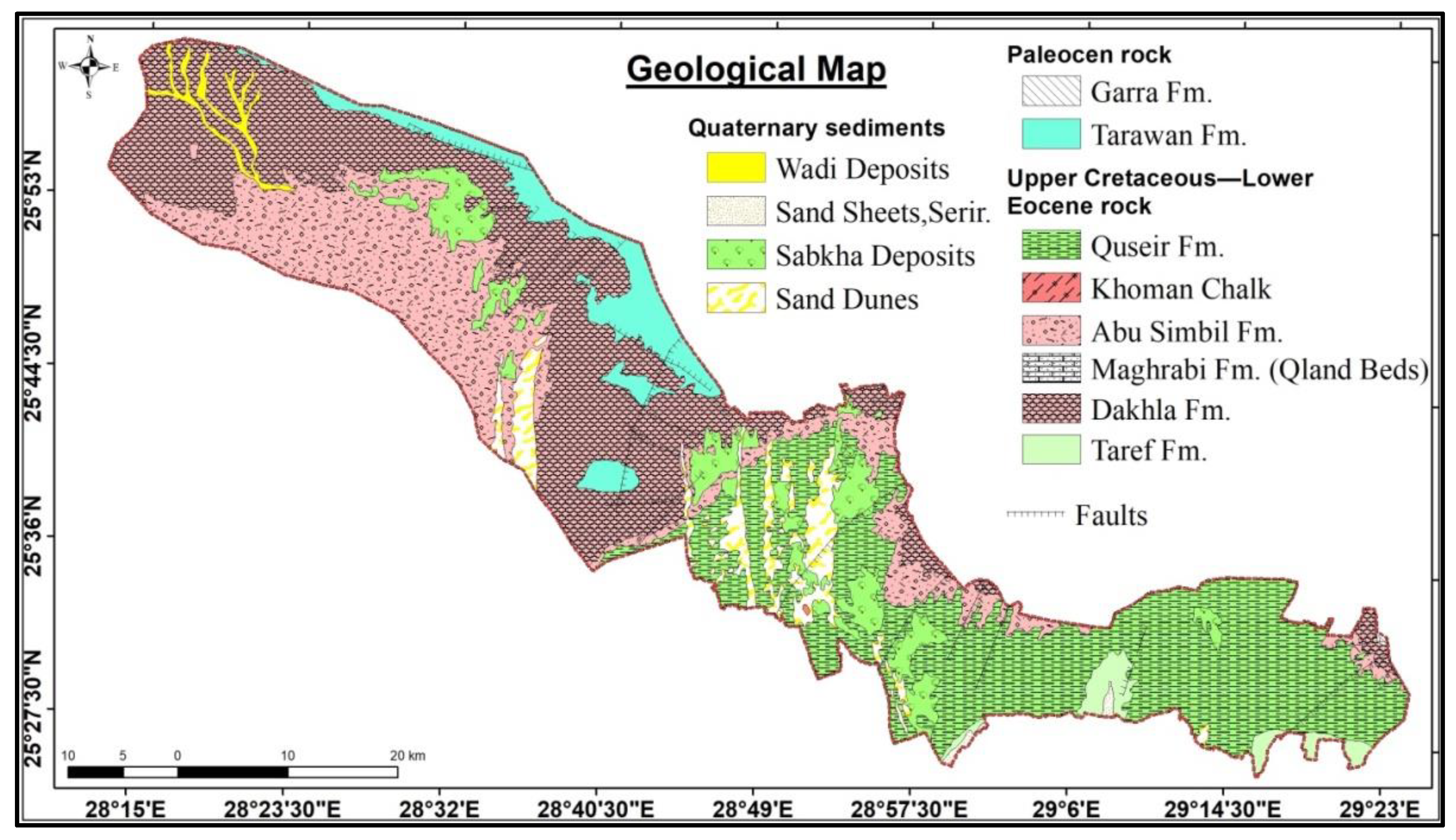
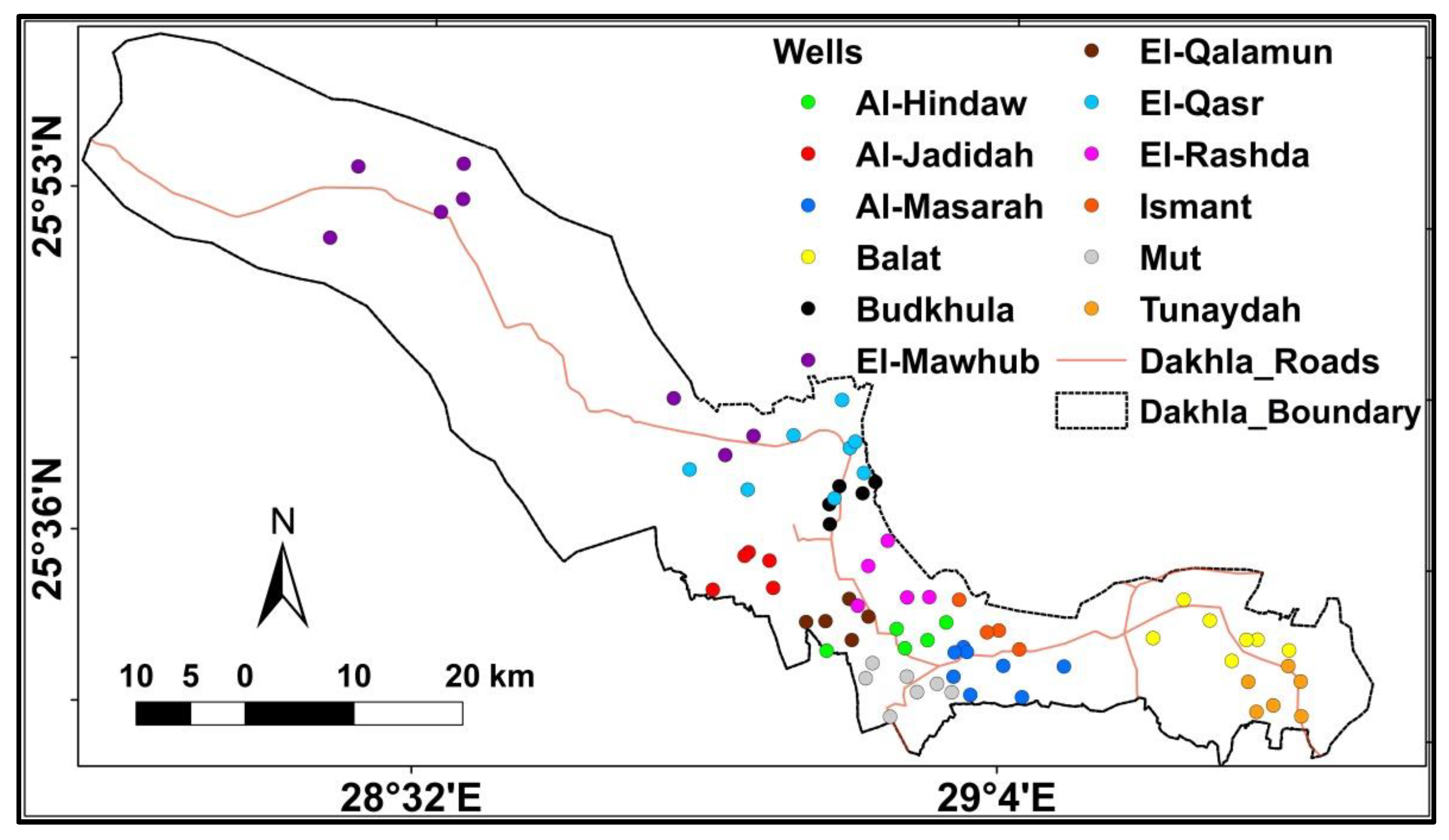
The Study Area
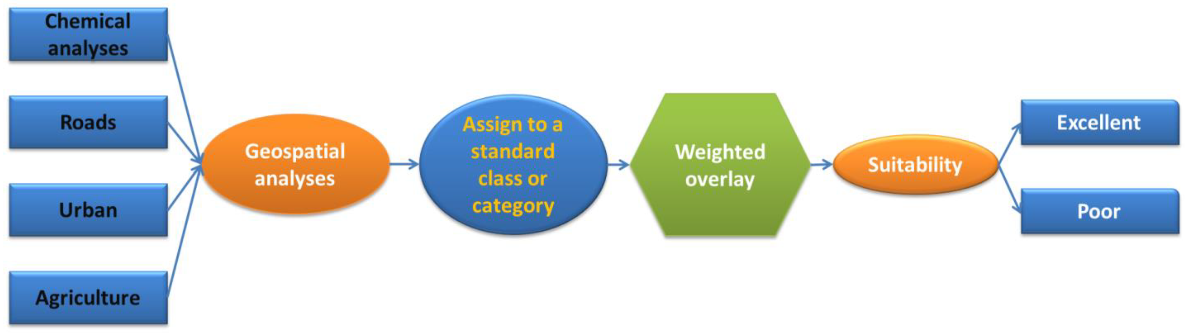
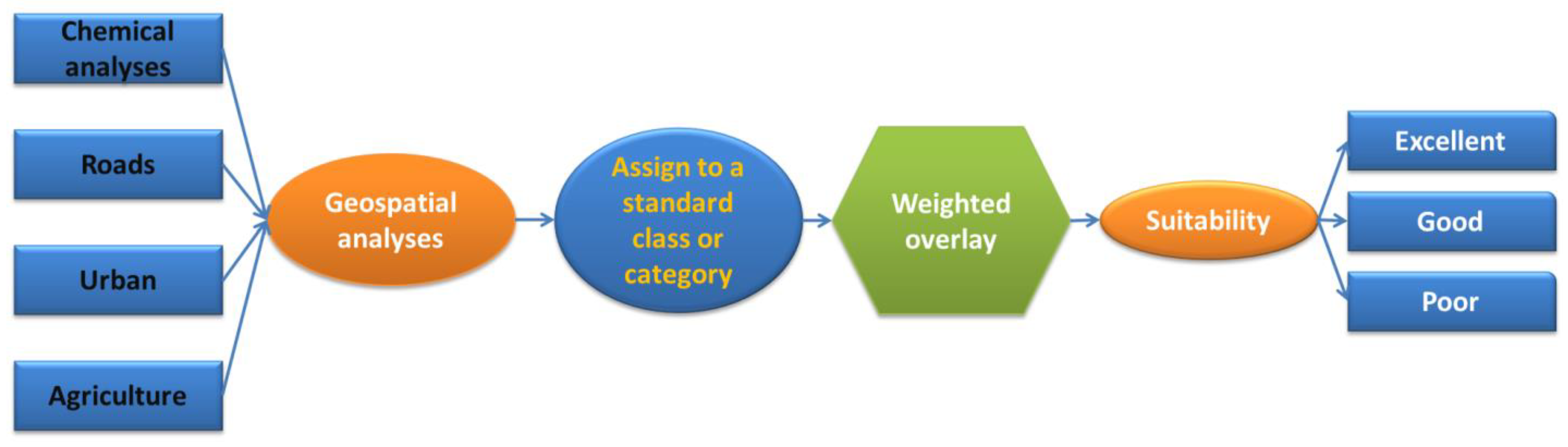
2. Materials and Methods
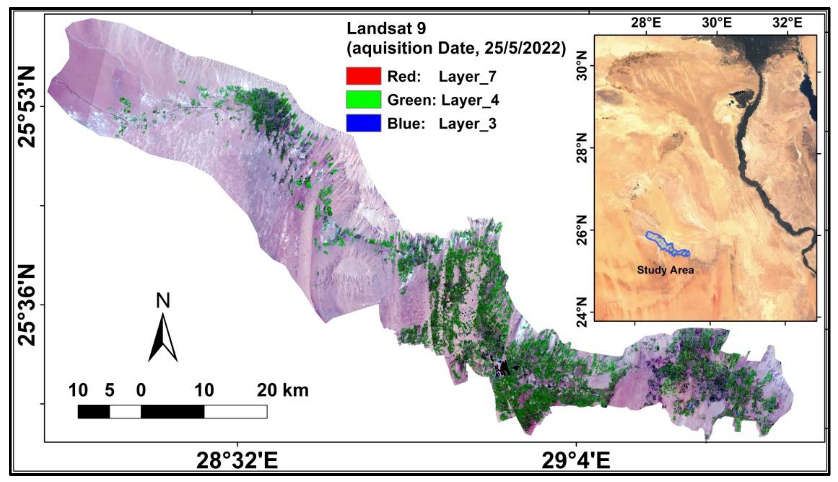
2.1. Data Collection and Processing
2.2. Soil Analysis
3. Results
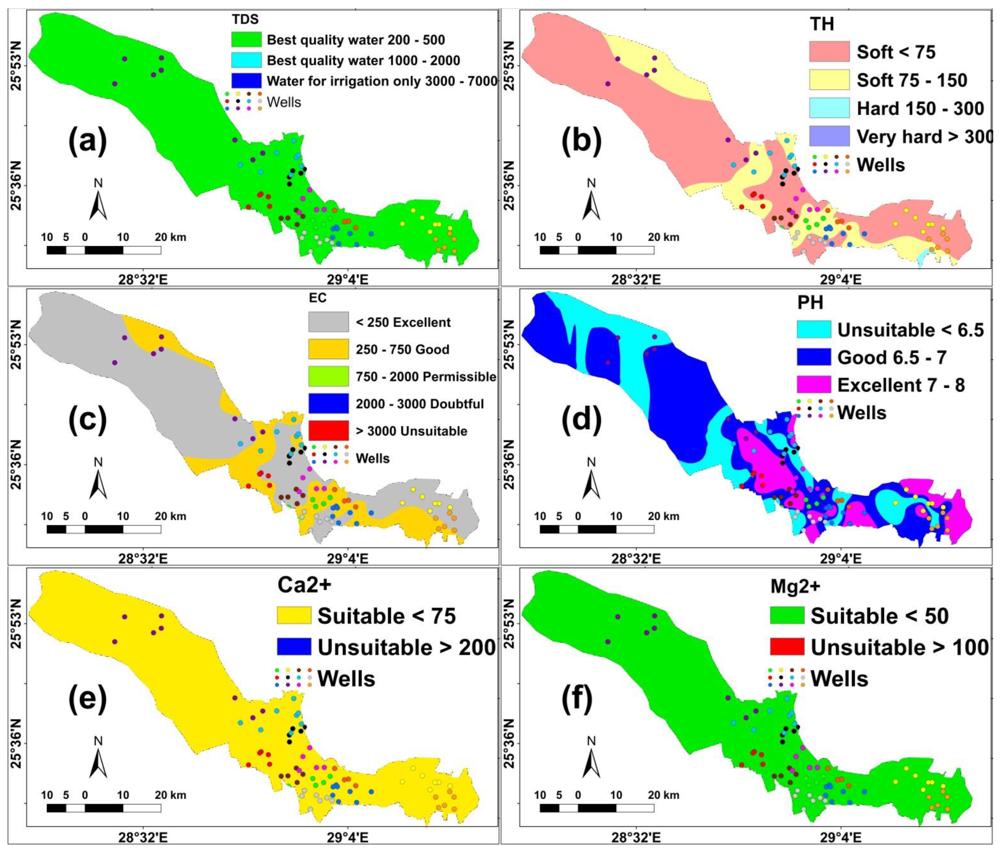
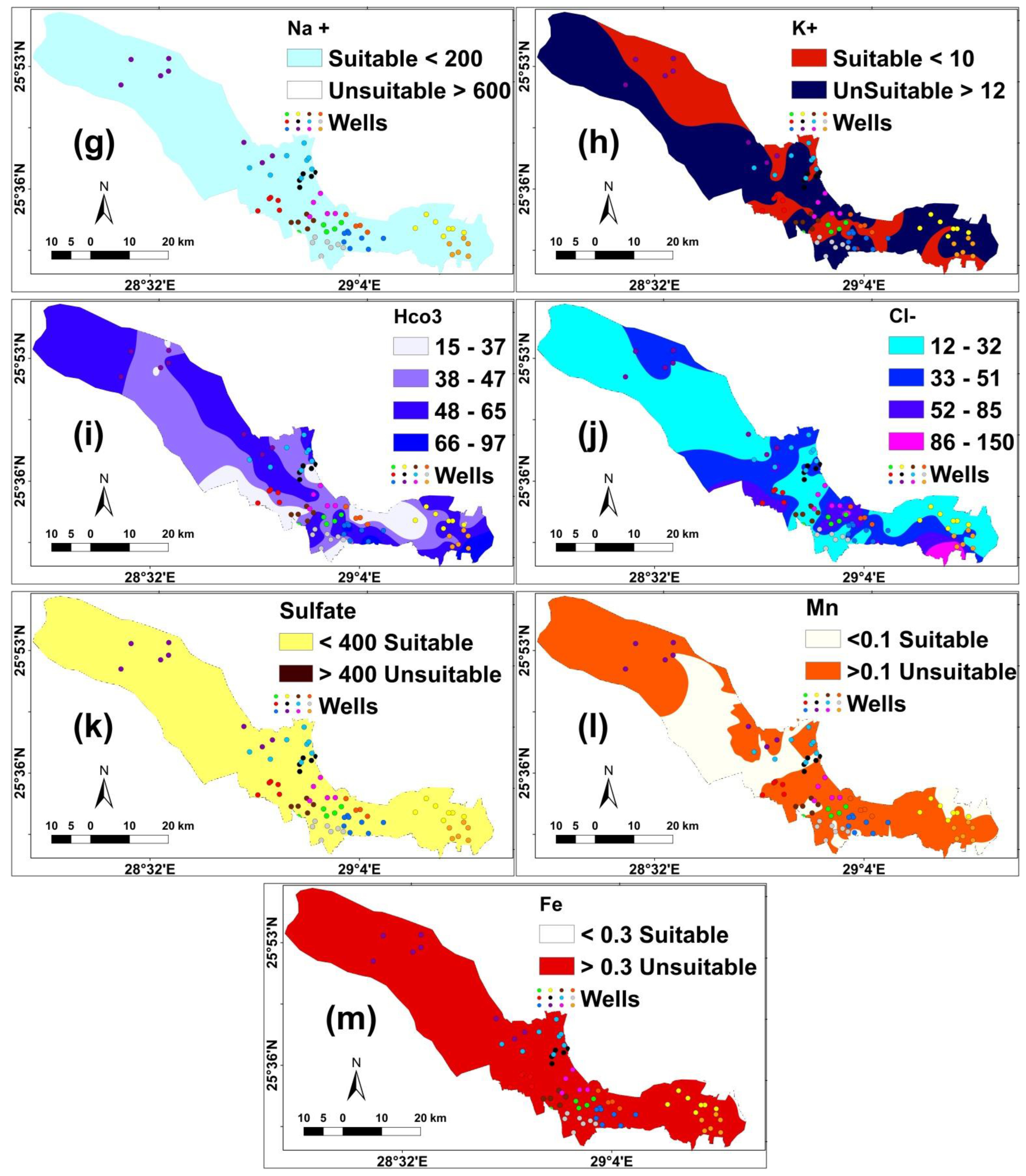
3.1. Hydrochemical Characteristics
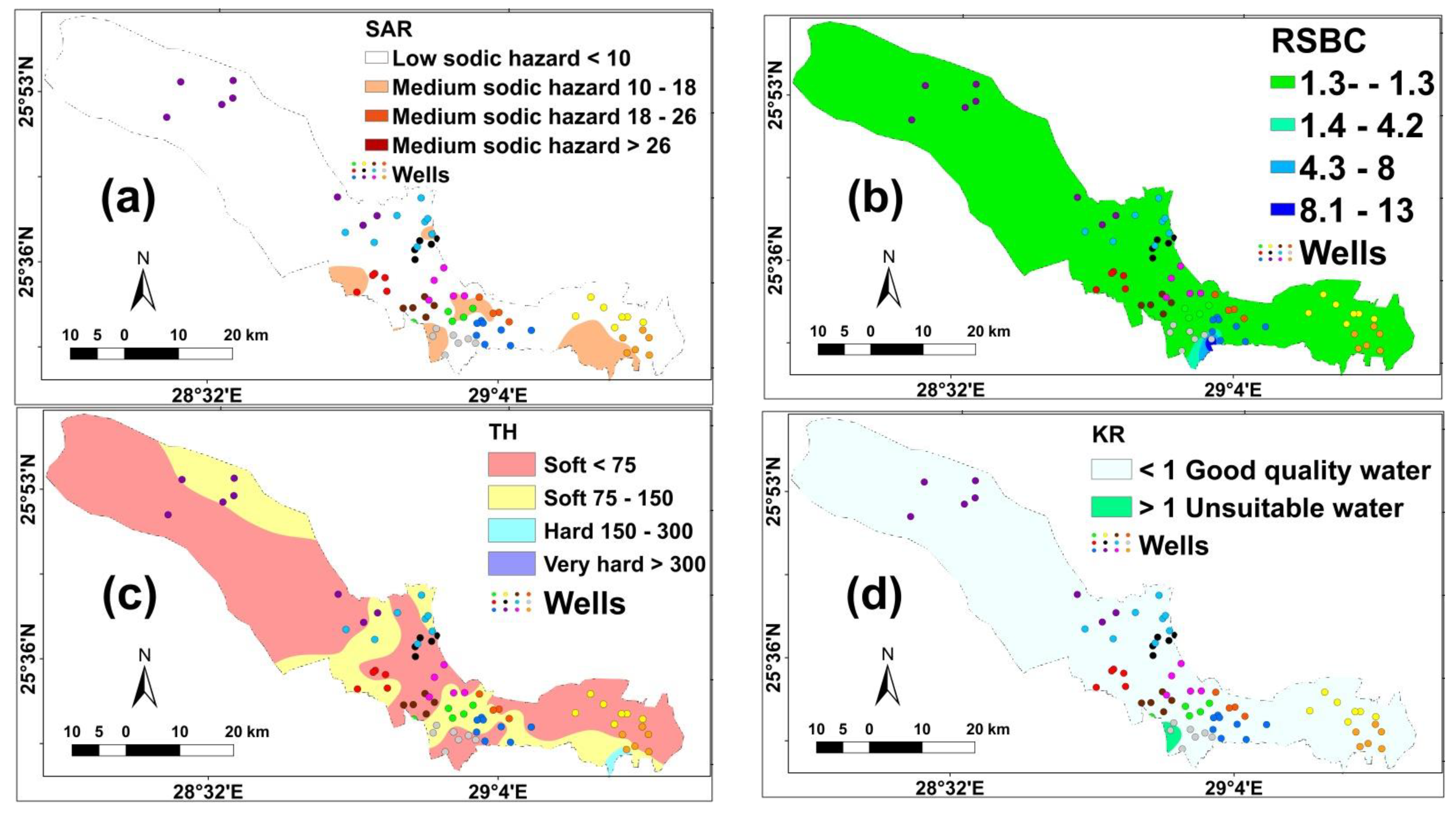
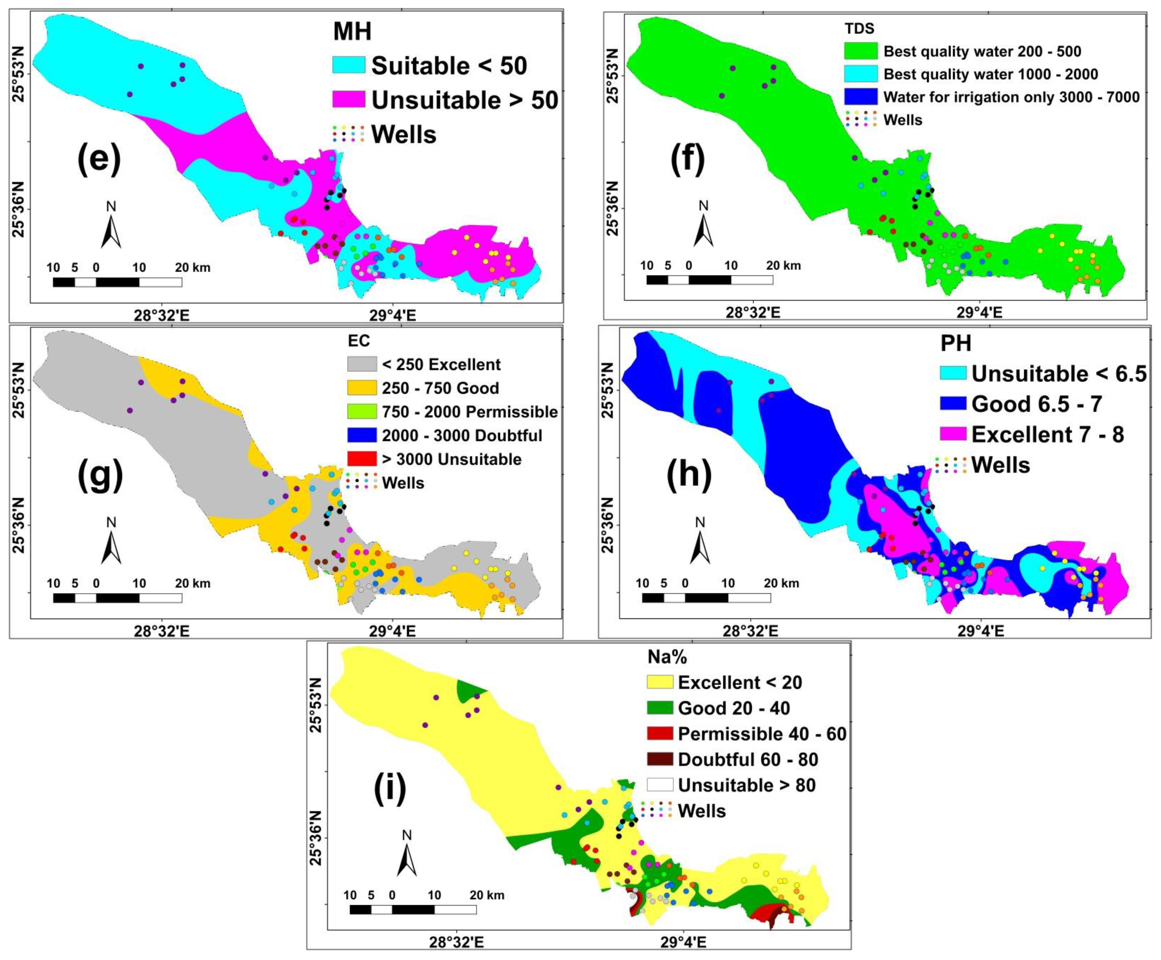
3.2. Health Risks of Water Quality Indices
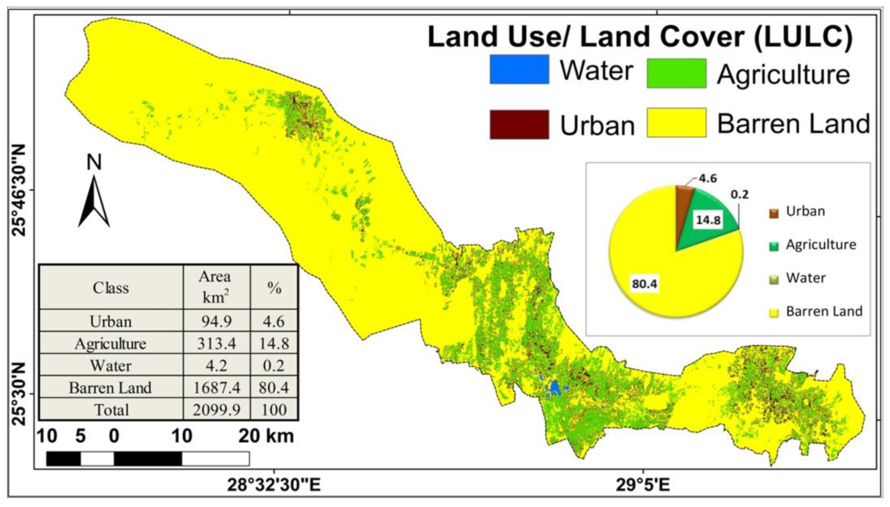
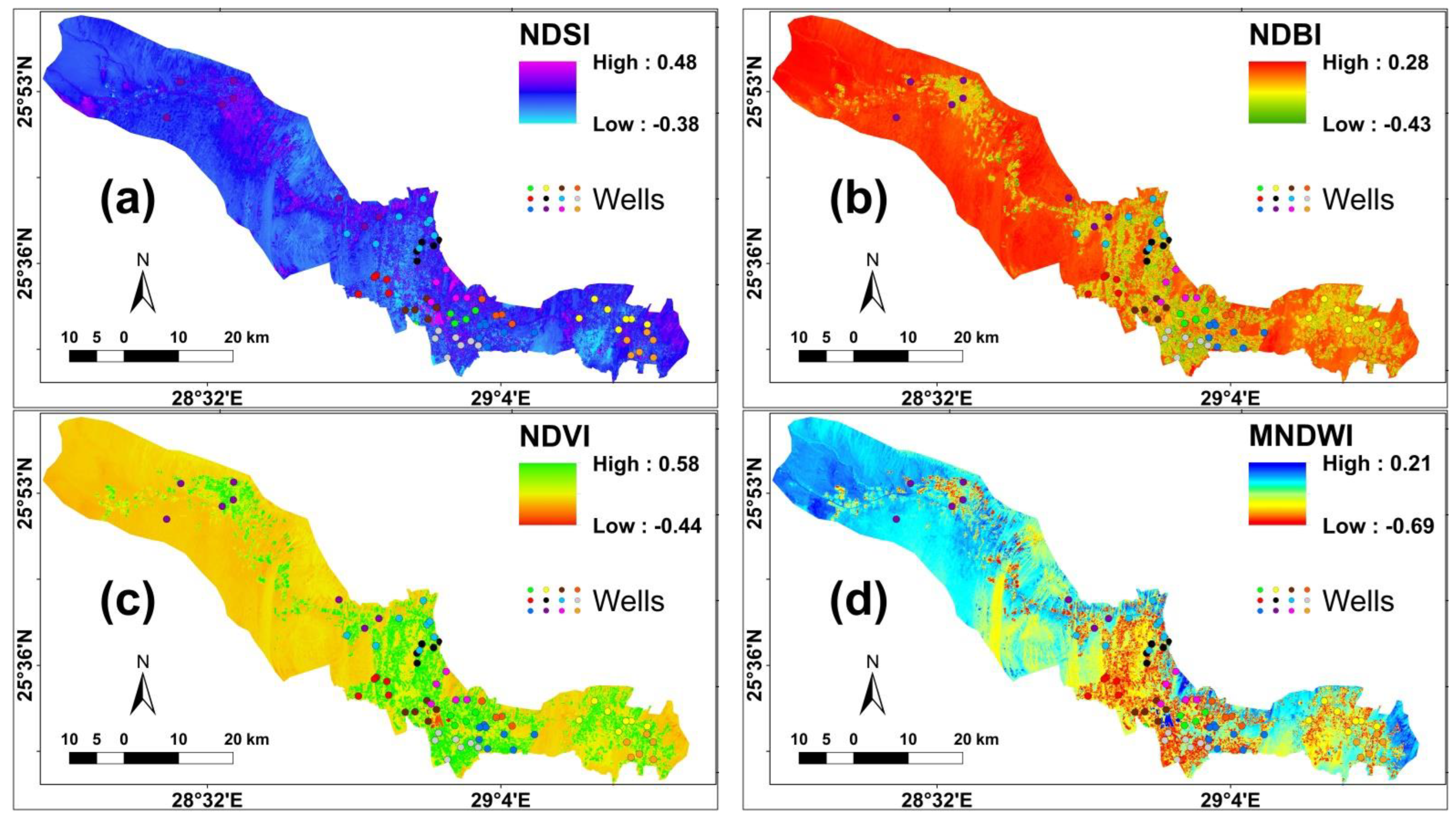
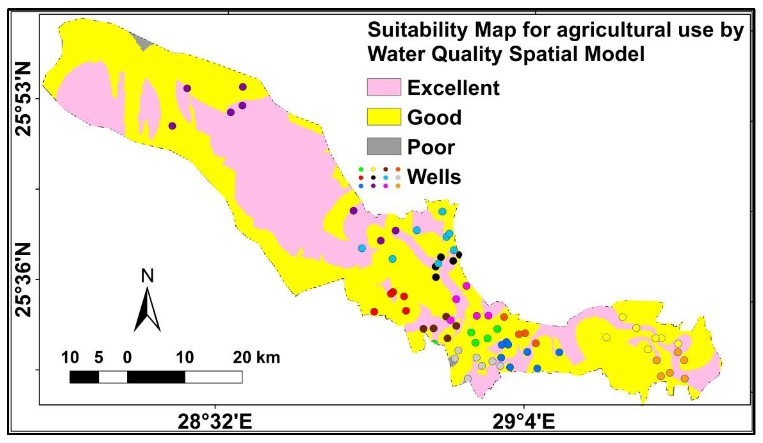
3.3. Land Use/Land Cover (LULC) Map
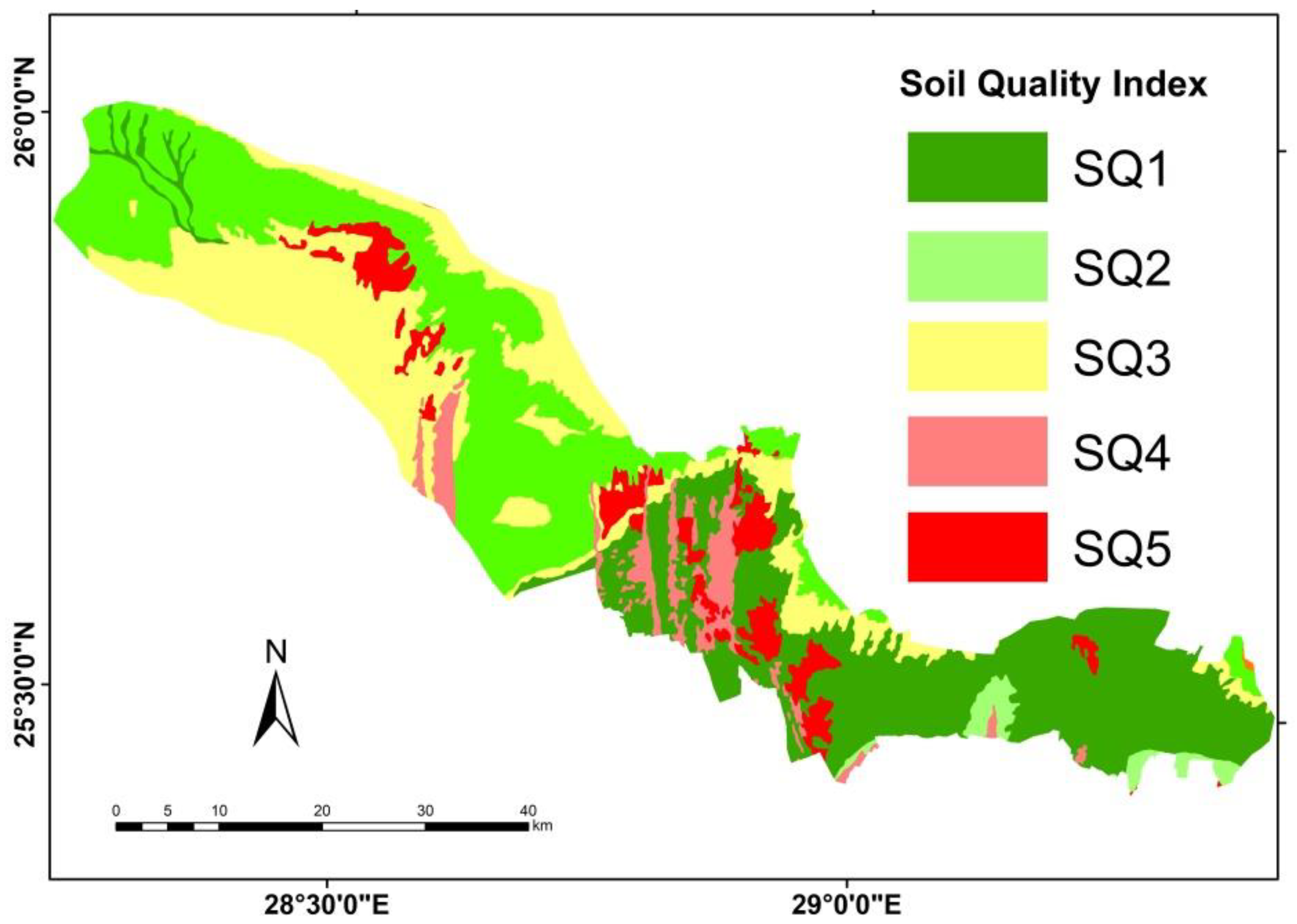
3.4. Soil Sof El-Dakhla Oasis
4. Discussion
4.1. Water Quality Assessment
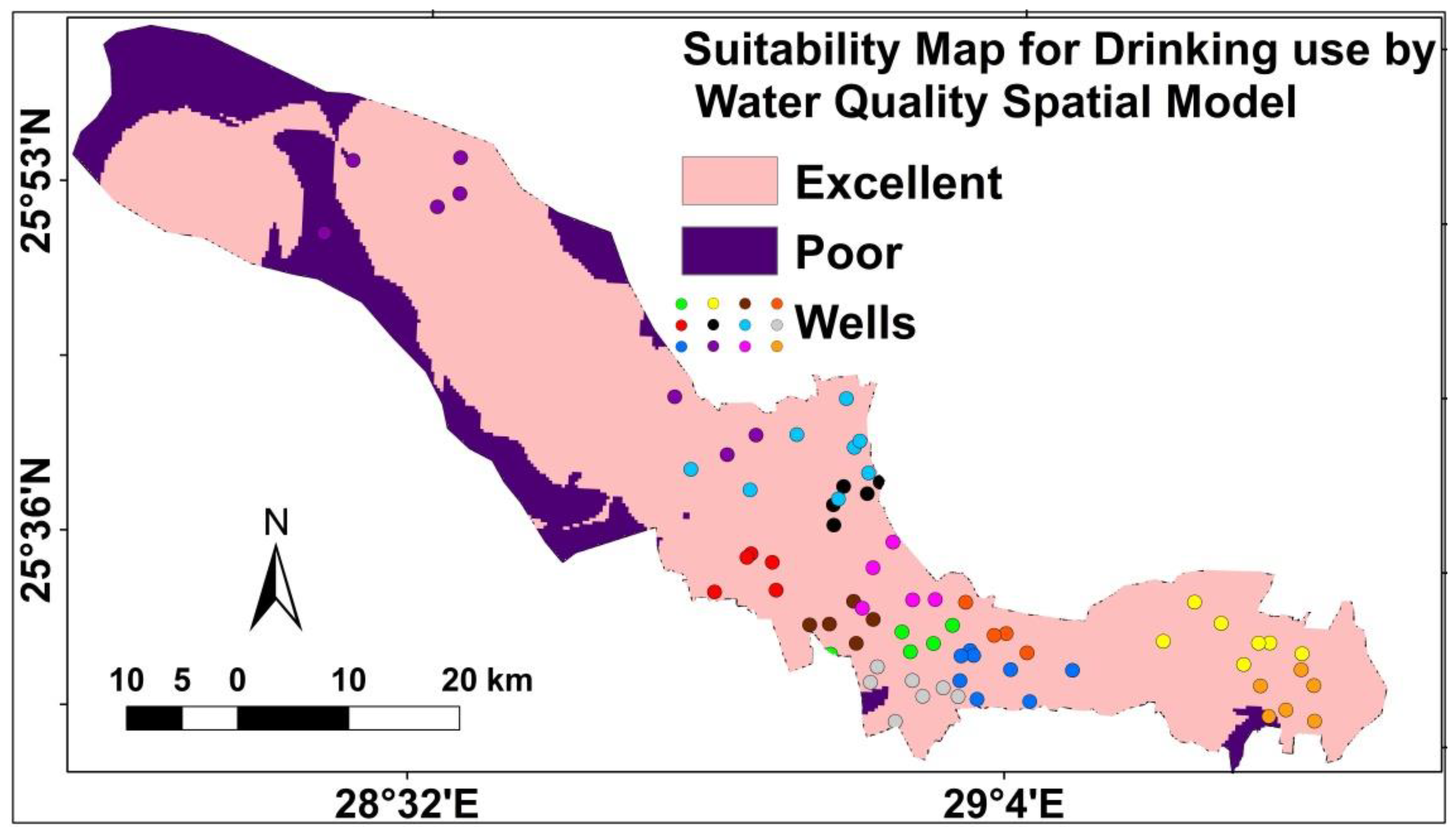
4.1.1. Water Quality Modeling for Drinking
4.1.2. Soil Quality
4.1.3. Water Quality Modeling for Irrigation
5. Conclusions and Recommendations
Author Contributions
Funding
Institutional Review Board Statement
Informed Consent Statement
Data Availability Statement
Acknowledgments
Conflicts of Interest
References
- Zhang, F.; Huang, G.; Hou, Q.; Liu, C.; Zhang, Y.; Zhang, Q. Groundwater quality in the Pearl River Delta after the rapid expansion of industrialization and urbanization: Distributions, main impact indicators, and driving forces. J. Hydrol. 2019, 577, 124004. [Google Scholar] [CrossRef]
- He, S.; Wu, J. Relationships of groundwater quality and associated health risks with land use/land cover patterns: A case study in a loess area, northwest China. Hum. Ecol. Risk Assess. 2019, 25, 354–373. [Google Scholar] [CrossRef]
- He, S.; Li, P.; Wu, J.; Elumalai, V.; Adimalla, N. Groundwater quality under land use/land cover changes: A temporal study from 2005 to 2015 in Xi’an, Northwest China. Hum. Ecol. Risk Assess. 2020, 26, 2771–2797. [Google Scholar] [CrossRef]
- Megahed, H.A.; Farrag, A. Groundwater potentiality and evaluation in the Egyptian Nile Valley: Case study from Assiut governorate using hydrochemical, bacteriological approach, and GIS techniques. Bull. Nat. Res. Cent. 2019, 43, 48. [Google Scholar] [CrossRef] [Green Version]
- Masindi, K.; Abiye, T. Assessment of natural and anthropogenic influences on regional groundwater chemistry in a highly industrialized and urbanized region: A case study of the Vaal River Basin, South Africa. Environ. Earth Sci. 2018, 77, 722. [Google Scholar] [CrossRef]
- Nickson, R.T.; McArthur, J.M.; Shresthn, B.; Kyaw-Myint, T.O.; Lowry, D. Arsenic and other drinking water quality issues, Muzaffargarh District, Pakistan. Appl. Geochem. 2005, 20, 55–68. [Google Scholar] [CrossRef]
- Amiri, V.; Bhattacharya, P.; Nakhaei, M. The hydrogeochemical evaluation of groundwater resources and their suitability for agricultural and industrial uses in an arid area of Iran. Groundw. Sustain. Dev. 2021, 12, 100527. [Google Scholar] [CrossRef]
- Kohlhepp, B.; Lehmann, R.; Seeber, P.; Kusel, K.; Trumbore, S.E.; Totsche, K.U. Aquifer configuration and geostructural links control the groundwater quality in thin-bedded carbonate–siliciclastic alternations of the Hainich CZE, central Germany. Hydrol. Earth Syst. Sci. 2017, 21, 6091–6116. [Google Scholar] [CrossRef] [Green Version]
- Kumar, M.; Ramanathan, A.L.; Mukherjee, A.; Sawlani, R.; Ranjan, S. Delineating sources of groundwater recharge and carbon in Holocene aquifers of the central Gangetic basin using stable isotopic signatures. Isot. Environ. Health Stud. 2019, 55, 254–271. [Google Scholar] [CrossRef]
- Gu, H.; Ma, F.; Guo, J.; Zhao, H.; Lu, R.; Liu, G. A spatial mixing model to assess groundwater dynamics affected by mining in a coastal fractured aquifer, China. Mine Water Environ. 2017, 37, 405–420. [Google Scholar] [CrossRef]
- Farid, H.U.; Mahmood-Khan, Z.; Ali, A.; Mubeen, M.; Anjum, M.N. Site-specific aquifer characterization and identification of potential groundwater areas in Pakistan. Pol. J. Environ. Stud. 2017, 26, 17–27. [Google Scholar] [CrossRef] [PubMed]
- Ali, S.; Shekhar, S.; Chandrasekhar, T.; Yadav, A.K.; Arora, N.K.; Kashyap, C.A.; Bhattacharya, P.; Rai, S.P.; Pande, P.; Chandrasekharam, D. Influence of the water-sediment interaction on the major ions chemistry and fluoride pollution in groundwater of the older Alluvial Plains of Delhi, India. J. Earth Syst. Sci. 2021, 130, 98. [Google Scholar] [CrossRef]
- Wang, Y.; Li, P. Appraisal of shallow groundwater quality with human health risk assessment in different seasons in rural areas of the Guanzhong Plain (China). Environ. Res. 2022, 207, 112210. [Google Scholar] [CrossRef]
- Zhao, H.; Song, F.; Su, F.; Shen, Y.; Li, P. Removal of cadmium from contaminated groundwater using a novel silicon/aluminum nanomaterial: An experimental study. Arch. Environ. Contam. Toxicol. 2021, 80, 234–247. [Google Scholar] [CrossRef]
- Li, Y.; Li, P.; Cui, X.; He, S. Groundwater quality, health risk and major influencing factors in the lower Beiluo River watershed of northwest China. Hum. Ecol. Risk Assess. 2021, 27, 1987–2013. [Google Scholar] [CrossRef]
- Metwaly, M.M.; AbdelRahman, M.A.E.; Abdellatif, B. Heavy metals and micronutrients assessment in soil and groundwater using geospatial analyses under agricultural exploitation in dry areas. Acta Geophys. 2022. [Google Scholar] [CrossRef]
- Darwish, M.H.; Megahed, H.A.; Farrag, A.A.; Sayed, A.G. Geo-Environmental Changes and Their Impact on the Development of the Limestone Plateau, West of Assiut, Egypt. J. Indian Soc. Remote Sens. 2020, 48, 1705–1727. [Google Scholar] [CrossRef]
- Belkhiri, L.; Boudoukha, A.; Mouni, L.; Baouz, T. Application of multivariate statistical methods and inverse geochemical modeling for characterization of groundwater—A case study: Ain Azel plain (Algeria). Geoderma 2010, 159, 390–398. [Google Scholar] [CrossRef]
- Darwish, M.H.; Galal, W.F. Spatiotemporal effects of wastewater ponds from a geoenvironmental perspective in the Kharga region, Egypt. J. Prog. Phys. Geogr. Earth Environ. 2020, 44, 376–397. [Google Scholar] [CrossRef]
- Galal, W.F.; Darwish, M.H. Geoenvironmental assessment of the mut wastewater ponds in the Dakhla Oasis, Egypt. Geocarto Int. 2022, 37, 3293–3311. [Google Scholar] [CrossRef]
- Zhang, M.; Huang, G.; Liu, C.; Zhang, Y.; Chen, Z.; Wang, J. Distributions and origins of nitrate, nitrite, and ammonium in various aquifers in an urbanized coastal area, south China. J. Hydrol. 2020, 582, 124528. [Google Scholar] [CrossRef]
- Gao, S.; Li, C.; Jia, C.; Zhang, H.; Guan, Q.; Wu, X.; Wang, J.; Lv, M. Health risk assessment of groundwater nitrate contamination: A case study of a typical karst hydrogeological unit in East China. Environ. Sci. Pollut. 2020, 27, 9274–9287. [Google Scholar] [CrossRef] [PubMed]
- Adimalla, N.; Taloor, A.K. Hydrogeochemical investigation of groundwater quality in the hard rock terrain of South India using Geographic Information System (GIS) and groundwater quality index (GWQI) techniques. Groundw. Sustain. Dev. 2020, 10, 100288. [Google Scholar] [CrossRef]
- Aminiyan, M.M.; Aitkenhead-Peterson, J.; Aminiyan, F.M. Evaluation of multiple water quality indices for drinking and irrigation purposes for the Karoon River, Iran. Environ. Geochem. Health 2018, 40, 2707–2728. [Google Scholar] [CrossRef]
- Al Maliki, A.A.; Abbass, Z.D.; Hussain, H.M.; Al-Ansari, N. Assessment of the groundwater suitability for irrigation near Al Kufa City and preparing the final water quality maps using spatial distribution tools. Environ. Earth Sci. 2020, 79, 330. [Google Scholar] [CrossRef]
- Chegbeleh, L.P.; Aklika, D.K.; Akurugu, B.A. Hydrochemical characterization and suitability assessment of groundwater quality in the Saboba and Chereponi Districts, Ghana. Hydrology 2020, 7, 53. [Google Scholar] [CrossRef]
- Li, P.; He, X.; Guo, W. Spatial groundwater quality and potential health risks due to nitrate ingestion through drinking water: A case study in Yan’an City on the Loess Plateau of northwest China. Hum. Ecol. Risk Assess. 2019, 25, 11–31. [Google Scholar] [CrossRef]
- Patel, M.P.; Bharat, G.; Akash, P.; Pankaj, P.; Beena, P. Climatic and anthropogenic impact on groundwater quality of agriculture dominated areas of southern and central Gujarat, India. Groundw. Sustain. Dev. 2020, 10, 100306. [Google Scholar] [CrossRef]
- Wu, J.; Li, P.; Wang, D.; Ren, X.; Wei, M. Statistical and multivariate statistical techniques to trace the sources and affecting factors of groundwater pollution in a rapidly growing city on the Chinese Loess Plateau. Hum. Ecol. Risk Assess. 2020, 26, 1603–1621. [Google Scholar] [CrossRef]
- Ali, S.; Fakhri, Y.; Golbini, M.; Thakur, S.K.; Alinejad, A.; Parseh, I.; Shekhar, S.; Bhattacharya, P. Concentration of fluoride in groundwater of India: A systematic review, meta-analysis and risk assessment. Ground. Sustain. Dev. 2019, 9, 100224. [Google Scholar] [CrossRef]
- Yasmin, G.; Islam, D.; Islam, M.T.; Shariot-Ullah, M.; Adham, A.K.M. Evaluation of groundwater quality for irrigation and drinking purposes in Barishal district of Bangladesh. Fundam. Appl. Agric. 2019, 4, 632–641. [Google Scholar] [CrossRef]
- Sarafraz, M.; Ali, S.; Sadani, M.; Heidarinejad, Z.; Bay, A.; Fakhri, Y.; Mousavi, K.A. A global systematic, review-meta analysis and ecological risk assessment of ciprofloxacin in river water. Int. J. Environ. Anal. Chem. 2021, 267, 128904. [Google Scholar] [CrossRef]
- Liu, L.; Wu, J.; He, S.; Wang, L. Occurrence and distribution of groundwater fluoride and manganese in the Weining Plain (China) and their probabilistic health risk quantification. Expos. Health 2021, 14, 263–279. [Google Scholar] [CrossRef]
- Gan, L.; Huang, G.; Pei, L.; Gan, Y.; Liu, C.; Yang, M.; Song, J. Distributions, origins, and health-risk assessment of nitrate in groundwater in typical alluvial-pluvial fans, North China Plain. Environ. Sci. Pollut. Res. 2022, 29, 17031–17048. [Google Scholar] [CrossRef] [PubMed]
- El-Rawy, M.; Ismail, E.; Abdalla, O. Assessment of groundwater quality using GIS, hydrogeochemistry, and factor statistical analysis in Qena governorate, Egypt. Desalin. Water Treat. 2019, 162, 14–29. [Google Scholar] [CrossRef]
- Ismail, E.; El-Rawy, M. Assessment of groundwater quality in West Sohag, Egypt. Desalin. Water Treat. 2018, 123, 101–108. [Google Scholar] [CrossRef]
- Snousy, M.G.; Ismail, E.; Zaki, R. Trace element occurrence and distribution problems in the irrigation water at El-Minia district, north upper Egypt. Arab. J. Geosci. 2019, 12, 582. [Google Scholar] [CrossRef]
- El Baba, M.; Kayastha, P.; Huysmans, M.; De Smedt, F. Evaluation of the groundwater quality using the water quality index and geo-statistical analysis in the Dier al-Balah governorate, Gaza Strip, Palestine. Water 2020, 12, 262. [Google Scholar] [CrossRef] [Green Version]
- Ismail, E.; Zaki, R.; Rapantova, N.; Licbinska, M.; Sharawi, H. Hydrogeochemical characteristics of the groundwater in the quaternary aquifer of western fringes of El-Minia governorate, Egypt using an integration of geochemical modeling and geo-statistical techniques. Desalin. Water Treat. 2020, 189, 134–151. [Google Scholar] [CrossRef]
- Abu Heleika, M.A.; Toney, S.; Ismail, E. Mapping of groundwater opportunities for multi-purpose use in Beni-Suef province, Egypt. Arab. J. Geosci. 2021, 14, 784. [Google Scholar] [CrossRef]
- Abdalazem, A.H.; Gamee, M.A.; Hamdan, A.; Awad, A.A.M.; Mohamed, A.G. Groundwater quality assessment for irrigation in West Edfu region, Aswan, Egypt. Assiut J. Agric. Sci. 2020, 51, 125–149. [Google Scholar] [CrossRef]
- Shamrukh, M.; Abdel-Wahab, A. Riverbank filtration for sustainable water supply: Application to a large-scale facility on the Nile River. Clean Technol. Environ. Policy 2008, 10, 351–358. [Google Scholar] [CrossRef]
- Sefelnasr, A.M.; Omran, A.A.K.; Abdel-Hak, H.A.; El Tahawy, W.S. GIS-based numerical modeling for the groundwater assessment: A case study in the quaternary aquifer, Assiut Governorate, Egypt. Arab. J. Geosci. 2019, 12, 624. [Google Scholar] [CrossRef]
- Gaber, M.E.; Soussa, H.; Fattouh, E. Groundwater quality evaluation for drinking and irrigation uses in Dayrout city Upper Egypt. Ain Shams Eng. J. 2021, 12, 327–340. [Google Scholar] [CrossRef]
- Huang, G.; Song, J.; Han, D.; Liu, R.; Liu, C.; Hou, Q. Assessing natural background levels of geogenic contaminants in groundwater of an urbanized delta through removal of groundwaters impacted by anthropogenic inputs: New insights into driving factors. Sci. Total Environ. 2022, 857, 159527. [Google Scholar] [CrossRef]
- Huang, G.; Han, D.; Song, J.; Li, L.; Pei, L. A sharp contrasting occurrence of iron-rich groundwater in the Pearl River Delta during the past dozen years (2006–2018): The genesis and mitigation effect. Sci. Total Environ. 2022, 829, 154676. [Google Scholar] [CrossRef]
- Huang, G.; Pei, L.; Li, L.; Liu, C. Natural background levels in groundwater in the Pearl River Delta after the rapid expansion of urbanization: A new preselection method. Sci. Total Environ. 2022, 813, 151890. [Google Scholar] [CrossRef]
- Ahn, H.; Chon, H. Assessment of groundwater contamination using geographic information systems. Environ. Geochem. Health 1999, 21, 273–289. [Google Scholar] [CrossRef]
- Levallois, P.; Thériault, M.; Rouffignat, J.; Tessier, S.; Landry, R.; Ayotte, P.; Girard, M.; Gingras, S.; Guavin, D.; Chiasson, C. Groundwater contamination by nitrates associated with intensive potato culture in Québec. Sci. Total Environ. 1998, 217, 91–101. [Google Scholar] [CrossRef]
- Negm, A.M.; Armanuos, A.M. GIS-based spatial distribution of groundwater quality in the Western Nile Delta, Egypt. In The Nile Delta. The Handbook of Environmental Chemistry; Negm, A., Ed.; Springer: Cham, Switzerland, 2016; Volume 55, pp. 89–119. [Google Scholar] [CrossRef]
- El-Zeiny, A.M.; Elbeih, S.F. GIS-Based Evaluation of Groundwater Quality and Suitability in Dakhla Oases, Egypt. Earth Syst. Environ. 2019, 3, 507–523. [Google Scholar] [CrossRef]
- Thorweihe, U.; Heinl, M. Groundwater Resources and Management in SW Egypt. Catena Suppl. Biominer. Process Iron Manganese Berl. Geowiss. 1993, 26, 99–121. [Google Scholar]
- Gad, M.I.; El Sheikh, A.E.; El Osta, M.M. Optimal management for groundwater of Nubian aquifer in El Dakhla depression, Western Desert, Egypt. Int. J. Water Resour. Environ. Eng. 2011, 3, 393–409. [Google Scholar]
- Ghoubachi, S.Y. The Hydrogeological Characteristics of the Nubia Sandstone System Aquifer in the Dakhla Depression, Western Desert, Egypt. Bachelor’s Thesis, Ain Shams University, Cairo, Egypt, 2001; 261p. [Google Scholar]
- Ebraheem, A.M.; Riad, S.; Wycisk, P.; Sefelnasr, A.M. A local-scale groundwater flow model for groundwater resources management in Dakhla Oasis, SW Egypt. Hydrogeol. J. 2004, 12, 714–722. [Google Scholar] [CrossRef]
- UNESCO. UNESCO Geological Map of the Western Desert. In Cooperation with UNDP, EGY/97/011; UNESCO Cairo Office: Cairo, Egypt, 1997. [Google Scholar]
- American Public Health Association (APHA). Standard Methods for the Examination of Water and Wastewater, 22nd ed.; American Public Health Association (APHA): Washington, DC, USA; American Water Works Association: Washington, DC, USA, 2012; p. 1496. ISBN 0875530133. [Google Scholar]
- World Health Organization. WHO Guidelines for Drinking-Water Quality: Fourth Edition Incorporating the First Addendum; World Health Organization: Geneva, Switzerland, 2017.
- Egyptian Higher Committee of Water (EHCW). Egyptian Standards for Drinking and Domestic Water According to the Act 27/1978 in Regulating of the Public Water Supplies; Egyptian Governmental Press: Cairo, Egypt, 2007.
- Ayers, R.S.; Westcot, D.W. Water Quality for Agriculture; FAO Irrigation and Drainage. Paper 29 Rev. 1; Food Agricultural Organisation: Rome, Italy, 1985; p. 185. Available online: https://www.fao.org/3/t0234e/t0234e.pdf (accessed on 10 September 2021).
- Raghunath, H.M. Ground Water, 2nd ed.; Wiley Eastern Ltd.: New Delhi, India, 1987; pp. 344–369. [Google Scholar]
- Wilcox, L.V. Classification and Use of Irrigation Waters; Salinity Lab. Circulation No. 969; U.S. Department of Agriculture: Washington, DC, USA, 1955.
- Doneen, L.D. Notes on Water Quality in Agriculture. Published as a Water Science and Engineering Paper 4001; Department of Water Science and Engineering, University of California: California, CA, USA, 1964. [Google Scholar]
- Richards, L.A. Diagnosis and Improvement of Saline and Alkali Soils. Agriculture Handbook; Department of Agriculture: Washington, DC, USA, 1954; pp. 1–160.
- Kelley, W.P. Permissible composition and concentration of irrigation waters. Trans. Am. Soc. Civil Eng. 1940, 66, 607–613. [Google Scholar] [CrossRef]
- Paliwal, K.V. Effect of gypsum application on the quality of irrigation waters. Madras Agric. J. 1967, 59, 646–647. [Google Scholar]
- Szabolcs, I.; Darab, C. The Influence of Irrigation Water of High Sodium Carbonate Content of Soils. In Proceedings of the 8th International Congress Soil Science Sodics Soils; Szabolics, I., Ed.; Research Institute for Soil Science and Agricultural Chemistry of the Hungarian Academy of Sciences, ISSS Trans II: Tsukuba, Japan, 1964; pp. 803–812. [Google Scholar]
- Todd, D.K. Groundwater Hydrology, 2nd ed.; Wiley: New York, NY, USA, 1980; pp. 1–315. [Google Scholar]
- Piper, C.S. Soil and Plants Analysis; Inter. Science, Inc.: New York, NY, USA, 1950. [Google Scholar]
- Jackson, M.L. Soil Chemical Analysis; Prentice-Hall of India Private Limited: New Delhi, India, 1973. [Google Scholar]
- Richards, L.A. Diagnosis and Improvement of Saline and Alkali Soils; Hand Book, No.60; United States Salinity Laboratory Staff, Department of Agriculture: California, CA, USA, 1954. [Google Scholar]
- Alvarenga, P.; Palma, P.; de Varennes, A.; Cunha-Queda, A.C. A contribution towards the risk assessment of soils from the São Domingos Mine (Portugal): Chemical, microbial and ecotoxicological indicators. Environ. Pollut. 2012, 161, 50–56. [Google Scholar] [CrossRef]
- Nelson, R.E. Carbonate and Gypsum. In Methods of Soil Analysis. Part 2—Chemical and Microbiological Properties, 2nd ed.; Page, A.L., Miller, R.H., Keeney, D.R., Eds.; American Society of Agronomy, Inc.: Madison, WI, USA; Soil Science Society of America, Inc.: Madison, WI, USA, 1982; pp. 181–197. [Google Scholar]
- Hesse, P.R. A Textbook of Soil Chemical Analysis; CBS Publishers & Distributors: Delhi, India, 1998. [Google Scholar]
- Bashour, I.; Sayegh, A. Methods of Analysis for Soil in Arid and Semi-Arid Regions; FAO: Rome, Italy, 2007; p. 119. [Google Scholar]
- Black, C. Methods of Soil Analysis, 2nd ed.; Chemical and Microbiological Properties. Agronomy Series No. 9; American Society of Agronomy, Inc.; Soil Science Society of America, Inc.: Madison, WI, USA, 1982. [Google Scholar]
- Sánchez-Navarro, A.; Gil-Vázquez, J.M.; Delgado-Iniesta, M.J.; Marín-Sanleandro, P.; Blanco-Bernardeau, A.; Ortiz-Silla, R. Establishing an index and identification of limiting parameters for characterizing soil quality in Mediterranean ecosystems. Catena 2015, 131, 35–45. [Google Scholar] [CrossRef]
- Ravindra, K.; Thind, P.S.; Mor, S.; Singh, T.; Mor, S. Evaluation of groundwater contamination in Chandigarh: Source identification and health risk assessment. Environ. Pollut. 2019, 255, 113062. [Google Scholar] [CrossRef]
- Meride, Y.; Ayenew, B. Drinking water quality assessment and its effects on residents health in Wondo genet campus, Ethiopia. Environ. Syst. Res. 2016, 5, 1. [Google Scholar] [CrossRef] [Green Version]
- Prasad, G.; Reshma, A.S.; Ramesh, M.V. Assessment of drinking water quality on public health at Alappuzha district, southern Kerala, India. Mater. Today Proc. 2021, 46, 3030–3036. [Google Scholar] [CrossRef]
- WHO Working Group. Health impact of acidic deposition. Sci. Total Environ. 1986, 52, 157–187. [Google Scholar] [CrossRef] [PubMed]
- Taylor, M.; Elliott, H.A.; Navitsky, L.O. Relationship between total dissolved solids and electrical conductivity in Marcellus hydraulic fracturing fluids. Water Sci. Technol. 2018, 77, 1998–2004. [Google Scholar] [CrossRef] [PubMed]
- Rao, N.S.; Rao, P.S.; Reddy, G.V.; Nagamani, M.; Vidyasagar, G.; Satyanarayana, N.L.V.V. Chemical characteristics of groundwater and assessment of groundwater quality in Varaha River Basin, Visakhapatnam District, Andhra Pradesh, India. Environ. Monit. Assess. 2012, 184, 5189–5214. [Google Scholar] [CrossRef] [PubMed]
- Adimalla, N.; Venkatayogi, S. Mechanism of fluoride enrichment in groundwater of hard rock aquifers in Medak, Telangana state, South India. Environ. Earth Sci. 2017, 76, 45. [Google Scholar] [CrossRef]
- WHO. WHO Chloride in Drinking-Water. In Background Document for Preparation of WHO Guidelines for Drinking-Water Quality; World Health Organization: Geneva, Switzerland, 2003. [Google Scholar]
- Alam, I.; Ur Rehman, J.; Nazir, S.; Nazeer, A.; Akram, M.; Batool, Z.; Ullah, H.; Hameed, A.; Hussain, A.; Tahir, M.B. Health risk assessment in different age-group due to nitrate, fluoride, nitrite and geo-chemical parameters in drinking water in Ahmadpur East, Punjab, Pakistan. Hum. Ecol. Risk Assess. 2021, 27, 1747–1763. [Google Scholar] [CrossRef]
- Sasikaran, S.; Sritharan, K.; Balakumar, S.; Arasaratnam, V. Physical, chemical and microbial analysis of bottled drinking water. Ceylon Med. J. 2012, 57, 111–116. [Google Scholar] [CrossRef] [Green Version]
- WHO. WHO Hardness in Drinking-Water. In Background Document for Development of WHO Guidelines for Drinking-Water Quality; World Health Organization: Geneva, Switzerland, 2011. [Google Scholar]
- Meyers, D. Mortality and water hardness. Lancet 1975, 1, 398–399. [Google Scholar] [CrossRef]
- Fingl, E. Laxatives and cathartics. In Pharmacological Basis of Therapeutics; Gilman, A.G., Ed.; MacMillan Publishing: New York, NY, USA, 1980. [Google Scholar]
- USEPA. Health Effects from Exposure to High Levels of Sulfate in Drinking Water Study; US Environmental Protection Agency, Office of Water: Washington, DC, USA, 1999; EPA 815-R-99-001.
- WHO. WHO Sulfate in Drinking-Water. In Background Document for Preparation of WHO Guidelines for Drinking-Water Quality; World Health Organization: Geneva, Switzerland, 2004. [Google Scholar]
- Joshi, D.M.; Kumar, A.; Agarwal, N. Assessment of the irrigation water quality of River Ganga in Haridwar District India, Rasayan. J. Chem. 2009, 2, 285–292. [Google Scholar]
- Deshmukh, K.K. Assessment of groundwater quality in Sangamner area for sustainable agricultural water use planning. Int. J. Chem. Sci. 2011, 9, 1486–1500. [Google Scholar]
- Deshmukh, A.; Werber, J.R.; Elimelech, M. The critical need for increased selectivity, not increased water permeability, for desalination membranes. Environ. Sci. Technol. Lett. 2016, 3, 112–120. [Google Scholar] [CrossRef]
- Dams, J.; Wodeamlak, S.T.; Batelaan, O. Predicting land-use change and its impact on the groundwater systems of the KleineNete catchment, Belgium. Hydrol. Earth Syst. Sci. 2008, 12, 1369–1385. [Google Scholar] [CrossRef] [Green Version]
- Barringer, T.H.; Dunn, D.; Battaglin, W.A.; Vowinkel, E.F. Problems and methods involved in relating land-use to groundwater quality. J. Am.Water Resour. Ass. 1990, 226, 1–9. [Google Scholar] [CrossRef]
- Tang, Z.; Engel, B.A.; Pijanowski, B.C.; Lim, K.J. Forecasting land-use change and its environmental impact at a watershed scale. J. Environ. Manag. 2005, 76, 35–45. [Google Scholar] [CrossRef] [PubMed]
- Bhaduri, B.; Harbor, J.; Engel, B.; Grove, M. Assessing watershed-scale, long-term hydrologic impacts of land-use change using a GIS-NPS model. Environ. Manag. 2000, 26, 643–658. [Google Scholar] [CrossRef] [PubMed]
- Abu Al Izz, M.S. Landform of Egypt; American University Press: Cairo, Egypt, 1971; p. 281. [Google Scholar]
- Belal, A.B.A.; Mohamed, E.S.S.; Abdellatif, M.A.; AbdelRahman, M.A.E. Soil Conditions of Dakhla Oasis, Western Desert, Egypt. In Sustainable Water Solutions in the Western Desert, Egypt: Dakhla Oasis; Iwasaki, E., Negm, A.M., Elbeih, S.F., Eds.; Earth and Environmental Sciences Library; Springer: Cham, Switzerland, 2021. [Google Scholar] [CrossRef]
- Selmy, S.A.H.; Abd Al-Aziz, S.H.; Jiménez-Ballesta, R.; JesúsGarcía-Navarro, F.; Fadl, M.E. Soil Quality Assessment Using Multivariate Approaches: A Case Study of the Dakhla Oasis Arid Lands. Land 2021, 10, 1074. [Google Scholar] [CrossRef]
- El-Rawy, M.; AbdelRahman, M.; Ismail, E. Integrated Use of Pollution Indices and Geomatics to Assess Soil Contamination and Identify Soil Pollution Source in El-Minia Governorate, Upper Egypt. J. Eng. Sci. Technol. 2020, 15, 2223–2238. [Google Scholar]


| Index | Mathematical Equation | References |
|---|---|---|
| pH | Ayers RS, Westcot DW [60] | |
| EC | WHO [58] | |
| TDS | Raghunath [61] | |
| SAR | SAR = Na+∕√(Ca + Mg)∕2 all ions in meq L−1 | Wilcox [62] |
| (Na%) | Na%= Na+ + K+ / Ca2+ + Mg2+ + Na+ + K+ × 100 | Doneen [63] |
| RSC | RSC = (HCO3− + CO2 3−) _((Ca2+ + Mg2+) all ions in meq L−1 | Richard [64] |
| KR | KR = Na+/(Ca2+ + Mg2+) all ions in meq L−1 | Kelley [65], and Paliwal [66] |
| MH | MAR = Mg2+/Ca2+ + Mg2+ × 100 all ions in meq L−1 | Szabolcs and Darab [67], Raghunath [61] |
| TH | TH = 2.497 Ca2+ + 4.115 Mg2+ ions in meq L−1 | Todd [68] |
| Parameter | Minimum | Maximum | Mean | |
|---|---|---|---|---|
| pH | 3 | 7.7 | 5.4 | |
| EC (μs cm−1) | 168 | 867 | 518 | |
| TDS | (mg L−1) | 101 | 520 | 310.5 |
| Ca2+ | 7.13 | 40.8 | 24 | |
| Mg2+ | 3.4 | 20.9 | 12.15 | |
| Na+ | 8 | 120 | 64 | |
| K+ | 4 | 25 | 14.5 | |
| HCO3− | 15.3 | 91.8 | 54 | |
| Cl− | 20.71 | 94.65 | 57.68 | |
| SO42− | 7.5 | 103.5 | 55.5 | |
| Fe2+ | 0.8 | 9.2 | 5 | |
| Mn2+ | 0.0 | 0.8 | 0.4 | |
| Parameter | Range | Water Class | Maximum Acceptable Concentration World Health Organization Standards (WHO 2017) [43] | Egyptian Maximum Permissible Limits (EHCW 2007) [44] | Groundwater Samples % |
|---|---|---|---|---|---|
| TDS (mg L−1) Davis and Dewiest (1966) [77] | <500 | Desirable for drinking | 500 | 1000 | 98.6% |
| 500–1000 | Permissible for drinking | 1.4% | |||
| >1000 | Unfit for drinking | --------- | |||
| TH Sawyer and McMcartly (1967) [78] | <75 | Soft | 500 | 500 | 59.5% |
| 75–150 | Moderately high | 40.5% | |||
| 150–300 | Hard | ------ | |||
| >300 | Very hard | ------ | |||
| EC (μs cm−1) | <500 | Suitable | 500 | - | 97.3% |
| >500 | Unsuitable | 2.7% | |||
| pH | <6.5 | Excellent | 6.5–8.5 | 6.5–8.5 | 17.6% |
| 6.5–8.5 | Good | 82.4% | |||
| >8.5 | Unsuitable | ------ | |||
| Ca2+ | <75 | Suitable | 75–200 | 75–200 | 96.2% |
| >200 | Unsuitable | 3.8% | |||
| Mg2+ | <50 | Suitable | 50–100 | 50–100 | 98.4% |
| >100 | Unsuitable | 1.6% | |||
| Na+ (mg L−1) | <200 | Suitable | 200–600 | 200–600 | 100% |
| >600 | Unsuitable | 0.0% | |||
| K+ (mg L−1) | <10 | Suitable | 10–12 | 10–12 | 100% |
| >12 | Unsuitable | 0.0% | |||
| HCO3− | <200 | Suitable | 200–500 | 200–500 | 100% |
| >500 | Unsuitable | 0.0% | |||
| Cl− | <250 | Suitable | 250–500 | 250–500 | 100% |
| >500 | Unsuitable | 0.0% | |||
| SO42− (mg L−1) | <400 | Suitable | 400 | 400 | 100% |
| >400 | Unsuitable | 0.0% | |||
| Mn2+ (mg L−1) | <0.1 | Suitable | 0.1 | 0.1 | 13.5% |
| >0.1 | Unsuitable | 86.5% | |||
| Fe2+ (mg L−1) | <0.3 | Suitable | 0.3 | 0.3 | 0.0% |
| >0.3 | Unsuitable | 100% |
| Factor | Weight | Sub-Criteria | Rating | Weight (Rank—Layer No.) +1 | Normalized Weight = Weight/Sum * 100 |
|---|---|---|---|---|---|
| Land use | 0.29 | Agriculture | 1 | 17 | 7 |
| Urban | 1 | 17 | 8 | ||
| Water | 1 | 17 | 7 | ||
| Roads | 1 | 17 | 7 | ||
| Groundwater quality indices for drinking | 0.26 | TDS | 2 | 16 | 6.5 |
| EC | 2 | 16 | 6.5 | ||
| pH | 2 | 16 | 6.5 | ||
| TH | 2 | 16 | 6.5 | ||
| 0.12 | Mn2+ | 3 | 15 | 6 | |
| Fe2+ | 3 | 15 | 6 | ||
| 0.15 | HCO3− | 4 | 14 | 5 | |
| Cl− | 4 | 14 | 5 | ||
| SO42− | 4 | 14 | 5 | ||
| 0.18 | Ca+2 | 5 | 13 | 4.5 | |
| Mg+2 | 5 | 13 | 4.5 | ||
| Na+ | 5 | 13 | 4.5 | ||
| K+ | 5 | 13 | 4.5 | ||
| Sum | 1 | 256 | 100 |
| Parameter | Water Class | Threshold | No. of Samples | Groundwater Samples % |
|---|---|---|---|---|
| SAR (epm) | Low sodic hazard | 0–10 | 74 | 100% |
| Medium sodic hazard | 10–18 | ------- | ----------- | |
| High sodic hazard | 18–26 | -------- | ----------- | |
| Very high sodic hazard | >26 | --------- | ----------- | |
| RSC (epm) | Good | <1.25 | 74 | 100% |
| Doubtful | 1.25–2.5 | ------- | ----------- | |
| Unsuitable | >2.5 | -------- | ----------- | |
| TH | Soft | <75 | 44 | 59.5% |
| Moderately hard | 75–150 | 30 | 40.5% | |
| Hard | 150–300 | -------- | ------------ | |
| Very hard | >300 | --------- | ------------ | |
| KR (epm) | Good quality water | <1 | 73 | 98.6% |
| Unsuitable water | >1 | 1 | 1.4% | |
| MH (epm) | Suitable | <50 | 34 | 46% |
| Unsuitable | >50 | 40 | 54% | |
| TDS (mg/L) | Best quality water | 200–500 | 74 | 100% |
| Water involving a hazard | 1000–2000 | --------- | --------- | |
| Water can be used for irrigation only with leaching and perfect drainage | 3000–7000 | --------- | --------- | |
| EC | Excellent | <250 | 50 | 67.6% |
| Good | 250–750 | 22 | 29.7% | |
| Permissible | 750–2000 | 2 | 2.7% | |
| Doubtful | 2000–3000 | --------- | --------- | |
| Unsuitable | >3000 | --------- | --------- | |
| pH | Excellent | 7–8 | 33 | 44.6% |
| Good | 6.5–7 | 28 | 37.8% | |
| Unsuitable | <6.5 | 13 | 17.6% | |
| Na% (epm) | Excellent | <20 | 52 | 70.3% |
| Good | 20–40 | 20 | 27% | |
| Permissible | 40–60 | --------- | --------- | |
| Doubtful | 60–80% | 1 | 1.4% | |
| Unsuitable | >80% | 1 | 1.4% |
| Factor | Weight | Sub-Criteria | Rating | Weight (Rank—Layer No.) +1 | Normalized Weight = Weight/Sum * 100 |
|---|---|---|---|---|---|
| Land Use | 0.37 | Agriculture | 1 | 13 | 10 |
| Urban | 1 | 13 | 9 | ||
| Water | 1 | 13 | 9 | ||
| Roads | 1 | 13 | 9 | ||
| Groundwater quality indices for irrigation | 0.32 | TDS | 2 | 12 | 8 |
| EC | 2 | 12 | 8 | ||
| pH | 2 | 12 | 8 | ||
| TH | 2 | 12 | 8 | ||
| 0.14 | RSC | 3 | 11 | 7 | |
| SAR | 3 | 11 | 7 | ||
| 0.12 | KR | 4 | 10 | 6 | |
| MH | 4 | 10 | 6 | ||
| 0.05 | Na% | 5 | 9 | 5 | |
| Sum | 1 | 151 | 100 |
Publisher’s Note: MDPI stays neutral with regard to jurisdictional claims in published maps and institutional affiliations. |
© 2022 by the authors. Licensee MDPI, Basel, Switzerland. This article is an open access article distributed under the terms and conditions of the Creative Commons Attribution (CC BY) license (https://creativecommons.org/licenses/by/4.0/).
Share and Cite
Megahed, H.A.; GabAllah, H.M.; AbdelRahman, M.A.E.; D’Antonio, P.; Scopa, A.; Darwish, M.H. Geomatics-Based Modeling and Hydrochemical Analysis for Groundwater Quality Mapping in the Egyptian Western Desert: A Case Study of El-Dakhla Oasis. Water 2022, 14, 4018. https://doi.org/10.3390/w14244018
Megahed HA, GabAllah HM, AbdelRahman MAE, D’Antonio P, Scopa A, Darwish MH. Geomatics-Based Modeling and Hydrochemical Analysis for Groundwater Quality Mapping in the Egyptian Western Desert: A Case Study of El-Dakhla Oasis. Water. 2022; 14(24):4018. https://doi.org/10.3390/w14244018
Chicago/Turabian StyleMegahed, Hanaa A., Hossam M. GabAllah, Mohamed A. E. AbdelRahman, Paola D’Antonio, Antonio Scopa, and Mahmoud H. Darwish. 2022. "Geomatics-Based Modeling and Hydrochemical Analysis for Groundwater Quality Mapping in the Egyptian Western Desert: A Case Study of El-Dakhla Oasis" Water 14, no. 24: 4018. https://doi.org/10.3390/w14244018