Article

Genesis Mechanisms of Geothermal Resources in Mangkang Geothermal Field, Tibet, China: Evidence from Hydrochemical Characteristics of Geothermal Water

1
Institute of Hydrogeology and Environmental Geology, Chinese Academy of Geological Sciences, Shijiazhuang 050061, China
2
Technology Innovation Center for Geothermal & Hot Dry Rock Exploration and Development, Ministry of Natural Resources, Shijiazhuang 050061, China
*
Authors to whom correspondence should be addressed.
Water 2022, 14(24), 4041; https://doi.org/10.3390/w14244041
Submission received: 16 September 2022 / Revised: 2 December 2022 / Accepted: 9 December 2022 / Published: 11 December 2022
(This article belongs to the Special Issue Hydrochemical Characteristics of Geothermal Water)

Abstract

:
The Mangkang geothermal field, distributed in the Mediterranean–Himalayas geothermal belt, hosts abundant hot springs whose geneses remain unclear. To determine the hydrochemical characteristics, reservoir temperature, circulation and recharge depths, and water–rock interactions of the geothermal water in the geothermal field, this study analyzed hydrochemical compositions and isotopes (2H, 3H, and 18O), conducted a PHREEQC simulation, and established a conceptual model to illustrate the genesis of geothermal resources in the Mangkang field. Based on the study of hot springs in Meipu, Qvzika, and Zulongpu villages and Rumei town, the following results are reported: The orifice temperatures of these hot springs vary between 18 °C and 67.5 °C. The hydrochemical composition analysis results indicate that the geothermal water in the hot springs is of hydrochemical type HCO3-Ca·Mg. Moreover, the geothermal water has high HBO2 and Na+ concentrations, suggesting protracted water runoff and strong water–rock interactions during its evolution. According to the mineral–water solubility equilibrium and silica geothermometers, it is estimated that the reservoir temperature of the Zulongpu hot spring is 47 °C and other hot springs have much higher reservoir temperatures of 116–130 °C. As indicated by geothermal gradients, annual temperatures, and reservoir temperatures, the geothermal water in Meipu and Qvzika villages has the greatest circulation depth, up to 3600–4300 m, followed by that in Rumei town (3700–4000 m) and Zulongpu village (~1500 m). The 2H-18O isotopic analysis of the geothermal surface water revealed that the geothermal water originates from meteoric water. The recharge elevation was inferred to be ~4700–4900 m. Moreover, the low 3H values (<1 Tu) suggest that the geothermal water is older than 40 years. The PHREEQC inverse simulation results indicated that the variation in the hydrochemical composition of the geothermal water results from the precipitation of chalcedony and dolomite, the absorption of NaX, and the loss of CaX2 during migration and storage.

1. Introduction

Geothermal resources can provide important supplies of clean and renewable energy [1,2,3,4,5,6,7,8,9,10]. Tibet is famous for its abundant high-temperature hot springs [11,12,13,14,15,16]. More than 600 geothermal spring sites have been found in Tibet [17], including more than 100 springs with temperatures of 86–94 °C. It is noteworthy that the temperature at borehole ZK04 in Yangbajing to the northwest of Lhasa City (Figure 1a) reaches 300 °C at a depth of 1500 m. Similarly, the Yangyi geothermal field to the northwest of Lhasa City has a reservoir temperature of up to 237 °C [15]. The Gudui geothermal field, about 150 km southeast of Lhasa City, is another typical Tibetan high-temperature geothermal field and has a reservoir temperature of 267 °C [18]. Tibet enjoys considerable geothermal resources, especially in its southern and eastern portions. Specifically, the exploitable geothermal resources in Tibet are 1700.77 × 1013 J/a, equivalent to 51.1 × 10⁴ tons of standard coal [13]. The geothermal water in Tibet has been extensively studied.
Most of the geothermal resources in this region, such as the Yadong–Gulu geothermal belt [19], the Cona–Woka geothermal belt [18], and the Zhaxikang geothermal field [20], are located along faults and are controlled by west-east- and north-east-trending active faults. These dominant faults in geothermal fields act as channels for gas and fluid migration from deep regions to the surface. For example, the geothermal resources in the Gudui geothermal field are controlled by tens of multi-stage EW- and NE-trending faults, especially late-stage faults that act as upwelling channels for deep geothermal fluids [21]. In the Zhaxikang geothermal field in southern Tibet, six NE-trending faults are ore-controlling faults with high dip angles (65–70°), along which hot springs are distributed [20]. All these faults were truncated by an early-stage NNW strike fault.
However, previous studies of the geothermal resources in Tibet have mostly focused on the central and southern parts of the region, and the causative mechanisms of the hot springs in the Mangkang geothermal field in the eastern part of Tibet remain unclear. Hot springs are widely distributed in the Mangkang geothermal field along deep regional faults (Figure 1). Previous studies of the Mangkang region focused on the hydrogeochemical and isotopic characteristics of saline springs in Yanjing, Qvzika rather than on geothermal water [12,22,23]. Hydrogeochemical and isotopic composition analyses are widely used to identify geothermal water type, recharge sources, reservoir temperatures, and circulation depth [24,25,26,27]. Based on geological features combined with PHREEQC simulations, the water–rock interaction process during the evolution of geothermal water was revealed [28,29,30].
This study systematically collected samples from the Mangkang geothermal field (Figure 1) and conducted hydrochemical analysis to determine the compositions of the geothermal water and the temperature and depth of corresponding geothermal reservoirs. Moreover, 2H and 18O isotopic composition analyses were carried out to infer the origin of the geothermal water. Based on the results, a PHREEQC model was established to represent the water–rock interaction process during the formation and migration of the geothermal water. Finally, a conceptual genesis model of the Mangkang geothermal field was constructed to illustrate the formation mechanisms of its geothermal water. This study will deepen the understanding of the genesis of geothermal resources in eastern Tibet.

2. Geological Setting

The Tibetan plateau has experienced a sequence of geological process including arc–arc/continent collision and oceanic crust subduction during its long-term evolutionary history [13,31,32]. In brief, the northwards movement of the Indian block attributed to the expansion of the Tethyan Ocean lithosphere since the Mesozoic era led to subsequent intra-continental deformation and the upword movement of the Tibetan plateau [31]. As a result, the plateau was divided into two first-order tectonic units (Figure 1a): Gondwana (Ⅰ) and Pancathaysia (II) by the Gonghu–Nujiang suture zone (F3) [13]. Furthermore, these two first-order units were subdivided into second-order tectonic units according to their internally enclosed blocks. Specifically, Gondwana comprises three second-order tectonic blocks: I1: Indian terrane; I2: Himalayan terrane and I3: Gangdisi–Nianqingtanggula terrane [13]. They are seprated by the Sivarick A-type subduction zone (F1) and Brahmaputra suture zone (F2). Pancathaysia (II) was subdived into four parts: II1: South Qiangtang–Zuokong terrane, II2: Qamdu–Simao terrane, II3: Bayan Har terrane, II4: Dege–Zhongdian terrane. The seperation boudaries between the terranes are the Shuanghu–Lancang suture zone (F4:) and the Yanghu–Jinshajiang suture zone (F5). Moreover, two large-scale collision boundaries are distributed at the north and south edges of the Tibetan plateau (Figure 1a).
The Mangkang geothermal field (the study area) is located in the Nanqiangtang–Zuogong and Changdu–Simao tectonic zones (Figure 1a) [12], which are separated by the Shuanghu–Lancangjiang suture zone. This geothermal field has undergone multiple movements, forming complex folds and fracture zones (Figure 1b). Its complex structural framework plays an important role in the formation, migration, and discharge of geothermal water [23]. Three dominant faults, i.e., Laoran–Nagu (Fm1), Zhuka–Qitangniuchang (Fm2), and Beiligong–Calixueshan (Fm3), are distributed in the geothermal field, as shown in Figure 1b.
The Laoran–Nagu Fault (Fm1) extends through Mangkang county, Xiaochangdu village, and Xiaochangdu Quzika village from north to south, inclining eastward (Figure 1b). This overthrust nappe fault overlies the Jurassic and Cretaceous red beds from east to west, forming a westward reverse syncline in the Mesozoic red beds in the Mangkang area. The hanging wall of the eastern Fm1 consists of Carboniferous limestones, Permian limestones and sandstones, and Triassic andesites. The Zhuka–Qitangniuchang fault (Fm2) runs through the whole area along the Lancang river in the NW direction, with the cross-section dipping southwestward and a dip angle of 35–50°. The footwall of the western F2 consists of the Middle Triassic Bushuai formation of volcanic rocks (mainly consisting of Triassic rhyolite and granodiorites) overlying Mesozoic red beds (Figure 1b and Figure 2). Massive hydrothermal mineralization occurs around this fault, including silicification, pyritization, polymetallic (Cu-Au-Ag-Hg-Pb-Zn) mineralization, and anomalous stream sediment assemblages. The Beiligong–Calixueshan Fault (Fm3) is an important boundary fault in the eastern part of this study area and is a transpressional strike-slip fault [22].
The igneous rocks in the study area mainly comprise Triassic rhyolites, as well as Triassic granodiorites, monzonitic granites, and Permian andesites (Figure 1b and Figure 2). The strata in the study area consist of Cretaceous sandstones, Jurassic sandstones, Permian limestones and sandstones, and Triassic sandstones and limestones. Quaternary sediments have a limited distribution, occasionally presenting along the Laoran–Nagu fault (Fm1). The metamorphic rocks in the study area are dominated by Permian metabasalts, which are distributed to the west side of the Beiligong–Calixueshan fault (Fm3).
The geothermal manifestations in the Mangkang geothermal field include hot springs in Rumei, Meipu, Qvzika, and Zulongpu villages. The occurrence of these springs is controlled by dominant faults (Fm1–Fm3) in the Mangkang geothermal field (Figure 1b). The coordinates of these springs are shown in Table 1. Table 2 shows that the orifice temperatures in the Rumei, Meipu, Qvzika, and Zulongpu villages measured in the field were 43 °C, 49.1 °C, 67.5 °C, and 18.1 °C, respectively.
The Lancang river flows from north to south, with an elevation difference of approximately 2000 m, and its tributaries are seasonal and recharged by snowmelt water [7]. The Heiqu river also flows from north to south. The temperature, pH, Eh, conductivity, and total dissolved solids (TDS) content of the river water measured in the field were 15.3 °C, 8.86, −109 mv, 268 μS/cm, and 134 ppm, respectively. The Zulongpu river, a tributary of the Heiqu, flows into the Heiqu river to the southeast of the Mangkang area, from south to north. The Youqu river flows from west to east in the region.
One cold spring in Zulongpu village was investigated, which occurs in Permian limestones, with a water flux of 2 L/s. The temperature, pH, Eh, conductivity, and TDS content of the spring water were found to be 18.1 °C, 7, 1 mv, 788 μS/cm, and 393 ppm, respectively. Meanwhile, one shallow well in Zulongpu village was surveyed; the well was 0.26 m in depth and 0.7 m in diameter. The temperature, pH, Eh, conductivity, and TDS content of the spring water in the well were 10.8 °C, 7.6, −33 mv, 613 μS/cm, and 306 ppm, respectively.

3. Sampling and Methods

The methodology of this study is presented in Figure 3.
As presented in Figure 1 and Table 1, one set of samples was collected from the geothermal spring water in each of four villages, i.e., Rumei, Meipu, Qvzika, and Zulongpu. Seven additional sets of samples were collected from Zulongpu village, including one set of cold spring water, one set of well water, and five sets of surface water samples.
All geothermal water samples were filtered through 0.45 μm pore membranes and stored in three 250 mL high-density polyethylene bottles, which were rinsed twice using the water to be sampled before sampling took place. For SiO2 analysis, the geothermal water samples were diluted to 10% of their initial concentration using deionized water. For analysis of metallic and cation elements, the samples were acidified to pH 1 using HNO3. No reagent was added to the samples for the inorganic anion analysis. The orifice temperature, pH, Eh, and conductivity (Table 2) were measured on site using a portable waterproof pH/EC/TDS meter (HI991300). Before measurement, parameters including the Eh value were corrected using a standard solution. The pH, Eh, and conductivity corresponding to the orifice temperature were measured in the field (Table 2).
The comprehensive water quality analysis and isotopic analyses (2H, 18O, and 3H) of all the samples were carried out at the Key Laboratory of Groundwater Sciences and Engineering of the Institute of Hydrogeology and Environmental Geology, Chinese Academy of Geological Sciences. The comprehensive analysis was carried out under a temperature of 23 °C and relative humidity of 54%. The detailed methodology made reference to DZ/T0064-1993 Groundwater Test Methods and GB/T8538-2008 Methods for Examination of Drinking Natural Mineral Water. The cation contents were obtained through inductively coupled plasma analyses (ICAP6300) and the anion contents were measured using chromatography (ICS1500). The charge-balance errors were <3%. Wavelength-scanned cavity ring-down spectroscopy (WS-CRDS) technology was employed to determine the δ2H and δ18O isotopic compositions at a temperature of 23 °C and relative humidity of 40%, using a L2130i isotope analyzer. The errors of δ18O and δ2H values were 0.025‰ and 0.1‰, respectively. The 3H isotopic composition was determined using an ultra-low background liquid scintillation spectrometer (Quantulus 1220), with an error of <1 Tu.

4. Results and Discussion

4.1. Water Geochemistry

As shown in Figure 4 and Table 2, the contents of major ions in the geothermal water samples were one or two orders of magnitude higher than those of the surface water. Compared with the samples of surface water and cold spring water, the geothermal water samples were richer in K+ Na+, HCO3, Cl, SO42−, and F and depleted in Mg2+ and Ca2+. The well-water samples were similar to the geothermal water samples, except they were enriched with Mg2+. The enrichment with Mg2+ is probably due to the water–rock interactions between the well water and the Mg-rich minerals (i.e., dolomites) from wall rocks consisting of dolomites and limestones.
The K+, Na+, HCO3, Cl, SO42−, and F concentrations in the geothermal water samples were 5.79–10.55 mg/L, 112.7–431.9 mg/L, 175.8–640.3 mg/L, 2.8–208.7 mg/L, and 1.69–14.26 mg/L, respectively (Table 2). By comparison, the same samples had much lower Mg2+ and Ca2+ concentrations of 0.49–7.95 mg/L and 8.21–50.26 mg/L, respectively. The geothermal water sample from Rumei town (sample RMZWQ001) had the highest TDS content (1299 ppm), about two or three times higher than the other geothermal water samples. The geothermal water sample from Qvzika village had the lowest TDS content of 375 ppm. By contrast, the geothermal water samples collected from Meipu and Zulongpu villages had similar TDS contents (648 and 583 ppm, respectively).
The high TDS content of geothermal water is likely to be related to the dissolution of abundant ions from host rocks, indicating strong water–rock interactions (Table 2). All the geothermal water samples were alkaline. The geothermal water sample from Qvzika village had the highest pH of 8.33 (Table 2), while the water samples from other sites had slightly lower pH values of 7.64–7.82. The surface water and cold spring water from Zulongpu village had relatively high pH (8–8.33). The well-water sample MKDW001 had a comparatively low pH (7.86). Piper diagrams (Piper, 1944) are widely applied to show the relationships between cations (Na+, K+, Ca2+, and Mg2+) and anions (HCO3, Cl, and SO42−). As represented in the Piper diagram (Figure 5), the geothermal water sample from Rumei town had a hydrochemical type of HCO3·Cl-Na, while other geothermal water samples were of HC03-Na type. The samples of surface water and well water from Zulong village were HCO3-Ca·Mg type, and cold spring-water sample MKQ001 was of HCO3-Ca·Na type.
Because water from adjacent stations probably has a hydraulic connection with the groundwater, the ion associations in water can be analyzed to provide an effective assessment of groundwater runoff [33]. Cl is useful candidate to trace the origin of ions because it is stable and difficult to absorb or react with minerals [34]. Linear fitting analysis of ions in the geothermal water was carried out to determine the relationships between Cl and Na+, Ca2+, NO3, H2SiO3, and HBO2 (Figure 6). As presented in Figure 6, neither Ca2+, NO3, H2SiO3, nor HBO2 had any close interrelationship with Cl, indicating that Ca2+, NO3, H2SiO3, and HBO2 likely originated from the dissolution of minerals. Compared to the surface water, the samples of cold spring water lacked HBO2, and the geothermal water samples had a significantly higher HBO2 concentration. Similarly, the geothermal water samples also contained rich quantities of H2SiO3. The dissolution of HBO2 and H2SiO3 in the geothermal water is probably due to the dissolution of silicate from the metamorphic and igneous rocks in the study area, such as metabasalts, metasandstones, andesites, and rhyolites (Figure 1b). These results indicate protracted water runoff and strong water–rock interactions, which are further evidenced by the high Na+ content in the geothermal water samples, with an order of magnitude twice that of the surface water sample (Table 2, Figure 5).
γNa/γCl, γCl/γHCO3, and γCl/γCa ratios provide clues for analyzing the migration and preservation of geothermal water [35,36]. Well-known as a metamorphic coefficient of geothermal water, the γNa/γCl ratio reflects the metamorphic degree of water and the closure degree of reservoirs [37]. As exhibited in Table 3, the geothermal water samples had γNa/γCl ratios in the range of 2.07–56.89 m, much higher than that of seawater (0.85). Therefore, the possibility that the geothermal water originated from seawater can be excluded. Meanwhile, the high γNa/γCl ratio indicates an origin in the form of meteoric water and a burial depth of >1000 m for the geothermal reservoirs. These inferences are consistent with the low γCl/γHCO3 ratio (0.005–0.0326) and γCl/γCa ratio (0.06–5.71), which suggest a high degree of evaporation affecting the geothermal water and a highly hydrodynamic condition, respectively.

4.2. Geothermal Reservoir Temperature

Mineral–water equilibrium geothermometers [33,38,39,40] and chemical geothermometers [27,41,42] are both extensively utilized to estimate geothermal reservoir temperatures. The former function according to the temperature at which the reactions between water and multiple minerals reach equilibrium [43,44], while the latter operate on the basis of the contents of certain chemical indices such as Si, K, Na, Ca, and Li [45,46,47,48,49,50].

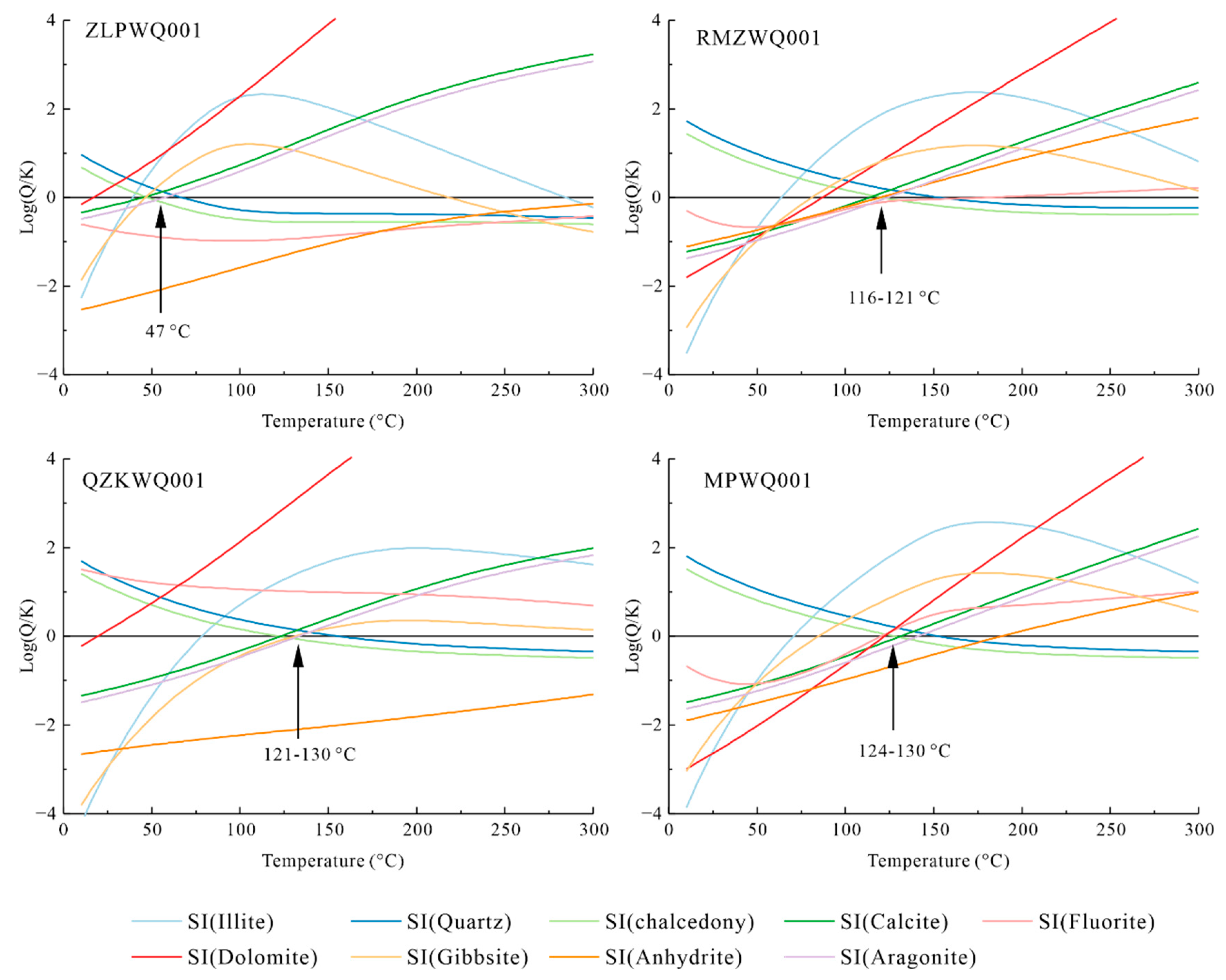
4.2.1. Mineral–Water Equilibrium Geothermometers

PHREEQC software is an effective tool for calculating the saturation degree of minerals in geothermal water with distinct hydrochemical compositions at different temperatures [29]. As demonstrated in Section 2 “Geological Setting” and Figure 1b, this study selected important mineral components of the rocks in the study area, including calcite, chalcedony, quartz, aragonite, anhydrite, fluorite, gibbsite, dolomite, and K-feldspar, to prepare the SI vs. temperature plots. These plots were employed to estimate geothermal reservoir temperature (Figure 7).
For geothermal water sample MPWQ001 from Meipu village, the trendlines of chalcedony, calcite, fluorite, and dolomite roughly intersected at the equilibrium line (EL) corresponding to a narrow temperature range of 123–130 °C, which was the estimated geothermal reservoir temperature in Meipu village. Similarly, for sample QZKWQ001 from Qvzika village, the trendlines of chalcedony, calcite, aragonite, and gibbsite roughly intersected near the EL with a corresponding temperature of 121–130 °C. For geothermal water sample RMWQ001 collected from Rumei town, the trendlines of five minerals chalcedony, calcite, aragonite, anhydrite, and fluorite intersected around the EL corresponding to a temperature range of 116–121 °C. For geothermal sample ZLPWQ001 from Zulongpu, the trendlines of calcite, chalcedony, and gibbsite intersected near the equilibrium line (SI = 0) corresponding to a temperature of 47 °C, which was the estimated reservoir temperature in Zulongpu village. Overall, the reservoir temperatures in Meipu, Qvzika, and Zulongpu villages and Rumei town were 123–130 °C, 121–130 °C, 47 °C, and 116–121 °C, respectively (Table 4).

4.2.2. Chemical Geothermometers

Chemical geothermometers consist of three main classes: (1) silica geothermometers based on the solubility of silica, which is assumed to reach reaction equilibrium with geothermal water [45]; (2) the silica-enthalpy model based on the relationship between enthalpy and silica content of water, a method that can eliminate the impacts of cold water mixing [46,49]. (3) cation geothermometers (K-Na-Ca, K-Na, and Na-Li) based on relationships among the concentrations of Na+, K+, and Ca2+ [47,48].

Silica Geothermometers

Silica geothermometers have been widely used to estimate the water temperatures of geothermal reservoirs [24,27], with quartz and chalcedony geothermometers the most widely used [33,41,52]. The geothermal resources in the study area are of the uplifted-mountain vein type, and the reservoir temperatures are not greater than 180 °C. Therefore, this study used a chalcedony geothermometer to estimate reservoir temperature. The equation for temperature calculation is shown as follows:
T = 1032/(4.52 − logCSi) − 273.15
where T represents the reservoir temperature calculated using the chalcedony geothermometer (unit: °C); CSi is the silica concentration calculated based on SiO2 (unit: mg/kg), corrected based on the pH and the total silica concentration [44].
As shown in Table 4, the reservoir temperatures of QZKWQ001, MPWQ001, RMZWQ001, and ZLPWQ001 were calculated using the chalcedony geothermometer to be 76.5 °C, 71.8 °C, 65.1 °C, and 55.3 °C, respectively. The reservoir temperature of ZLPWQ001 determined using the silica geothermometer was slightly higher than that estimated based on the mineral–water equilibrium geothermometer (Table 4). This occurred probably due to an overestimation of the silica concentration in the geothermal water, which is likely to have arisen from the dissolution of amorphous silica when the geothermal water encountered gel near the surface [51]. For the other geothermal water samples, estimated temperatures based on silica content were significantly low, probably caused by the mixing of cold water when the geothermal water rises. Overall, silica geothermometers are not suitable for estimating reservoir temperatures in this field.

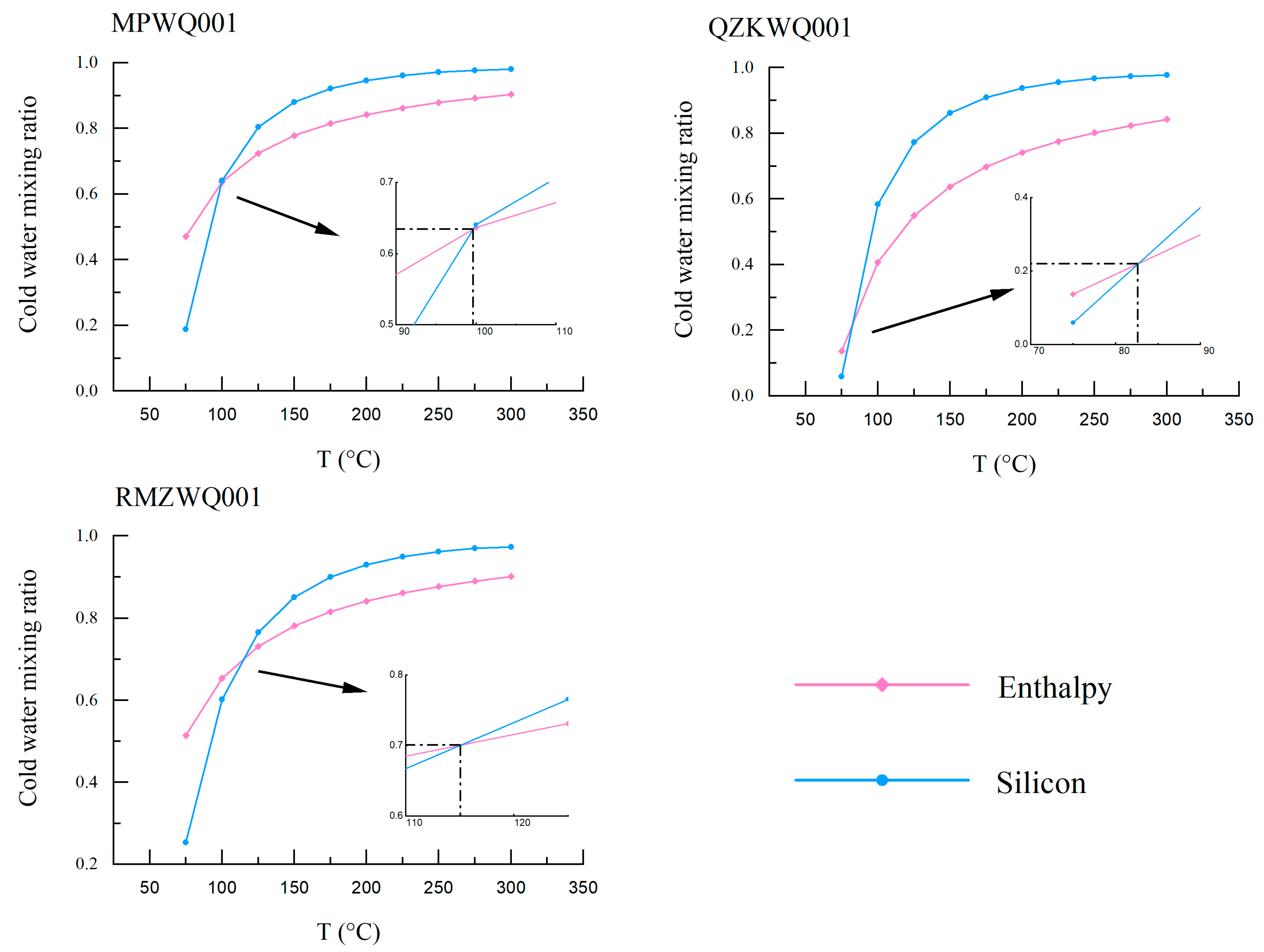
Silica-Enthalpy Model

For geothermal water samples QZKWQ001, MPWQ001, and RMZWQ001, the influence of mixing with cold water could be corrected using the silica-enthalpy model [46,49,53]. The equations are as follows:
Sc·x + Sh·(1 − x) = Ss
SiO2c·x + SiO2h·(1 − x) = SiO2s
where Sc is the enthalpy of cold surface water (cal/g); Sh is the initial enthalpy of geothermal water (cal/g); Ss is the final enthalpy of the mixed spring water (cal/g); SiO2c is the SiO2 content in cold surface water (mg/L); SiO2h is the initial SiO2 content in the geothermal water (mg/L); SiO2s is the final SiO2 concentration of the mixed spring water (mg/L); x is the proportion of the mixed cold surface water.
For coexistence of steam and liquid water, Table 5 shows the relationships between quartz solubilities and the enthalpies of liquid water at specified temperatures and pressures [49,54,55,56]. Quartz solubility is a function of the temperature of liquid water. The corresponding equation is presented:
T = 1309/(5.19 − logC) − 273.15
The surface water sample from Zulongpu had an average temperature of 12.8 °C and an average SiO2 concentration of 2.15 (Figure 1b; Table 2). Figure 8 shows the temperature vs. water-mixing ratio plots of the geothermal samples from the study area, prepared based on Equations (2) and (3). The cold-water mixing ratios of samples RMZWQ001, QZKWQ001, and MPWQ001 were 63%, 22%, and 70%, respectively (Table 4). The reservoir temperatures corresponding to these ratios were 112 °C, 85 °C, and 115 °C, respectively (Table 4). No surface water sample was collected from Qvzika village, and the surface water sample used in the silica-enthalpy model was collected from Zulongpu village. However, compared with the springs of other places, saline springs such as are widely distributed in Qvzika village have different hydrochemical components including silica. Therefore, the silica-enthalpy model was not suitable to estimate the reservoir temperature in Qvzika.
In summary, using the silica-enthalpy model the reservoir temperatures of geothermal water in Meipu village and Rumei town were estimated to be 112 °C and 115 °C, respectively (Table 4).

Cation Geothermometers

Cation geothermometers (K-Na-Ca, K-Na, and Na-Li) were developed based on molar concentrations of Na, K, and Ca in geothermal water, on the premise that cation exchange reactions (K and Na with feldspar) are in equilibrium [47,48]. The Na-K-Mg ternary diagram [57] is a valid tool to judge the samples’ degree of equilibrium. As presented in Figure 9, the geothermal water samples from Rumei village fell into partial equilibrium and the mixed water zone in the diagram, while those from other sites in the Mangkang area fell into the immature water zone. Therefore, cation geothermometers were not suitable for use in this study.
In conclusion, silica geothermometers were not suitable for geothermal water sample ZLPWQ001 from Zulongpu. Instead, a reasonable reservoir temperature (47 °C) was estimated based on the mineral–rock equilibrium and the silica-enthalpy model (Table 4). The reservoir temperatures of the geothermal water samples from Qvzika village were determined to be 121–130 °C, based on the mineral–water equilibrium geothermometer. For the geothermal water samples from Meipu town and Rumei village, reservoir temperatures of 112–130 °C and 115–121 °C, respectively, were determined using the mineral–water equilibrium geothermometer and the silica-enthalpy model.

4.3. Thermal Circulation Depth

The geothermal circulation depth can be calculated using the following equation [14]:
D = (t1 − t2)/G + h
where D is the geothermal circulation depth (m); t1 is the geothermal reservoir temperature (°C); t2 is the average annual local temperature (°C); G is the geothermal gradient (°C/100 m); and h is the thickness of the constant temperature zone (m).
The average annual local temperature, geothermal gradient, and the thickness of the constant temperature zone in the Mangkang area are 3 °C, 30 °C/km, and 20 m, respectively [12,17]. As shown in Table 6, the calculated reservoir depth (~1500 m) in Zulongpu village was the lowest, while the estimated reservoir depths in Meipu village, Qvzika village, and Rumei town were quite close to each other at 3600–4300 m, 3900–4300 m, and 3700–4000 m, respectively.

4.4. 2H and 18O Values

As presented in Table 7 and Figure 10, the δ2H and δ18O values of the geothermal water samples from the Mangkang geothermal field had a narrow range of −145 to −158 and −19.3 to −20.4, respectively, and those of the surface water samples from Zulongpu Village varied from −146 to −141 and from −18.8 to −18.2, respectively. The linear fitting formula of the surface water in Zulongpu is y = 6.72x − 19 (Table 7, Figure 10). The geothermal water samples from Meipu and Rumei villages and Zulongpu town were distributed along the fitting line of the meteoric water in Zulongpu village. By contrast, geothermal water sample QZKWQ001 and the surface water sample (from the Lancang river) from the Qvzika village fell along the global meteoric water line [12]. This result indicates that all the geothermal water originated from meteoric water. In general, the decrease in the δ2H and δ18O values with increased elevation can be ascribed to topographic precipitation [14,58]. The recharge elevation can be calculated using the following equation [59]:
δ18O = −0.0031H − 7.75
where H denotes the recharge elevation.
As presented in Table 7, the recharge elevation (~4400 m) of the geothermal water in Qvzika village is the lowest, while the recharge elevations of the geothermal water in Meipu village, Rumei town, and Zulongpu village are approximately similar at ~4800 m, ~4700 m, and ~4900 m, respectively.
Table 7 shows the 3H composition of the geothermal water, cold spring water, and well-water samples. The δ3H values of all these samples were <1 Tu, suggesting that the geothermal water in the Mangkang geothermal field is older than 40 years. The well water was found to be the youngest, while the geothermal water is the oldest, indicating long geothermal water runoff, deep geothermal circulation, and the mixing of a small amount of freshwater.

4.5. Water-Rock Interactions

PHREEQC is an effective program for the study of the water–rock interactions between geothermal water and host rocks [29,30]. In this study, samples of surface water and geothermal water were used respectively as the start and end members of the model of the Mangkang geothermal field.
As mentioned in Section 4.2, the dominant minerals in the Mangkang geothermal field include calcite, chalcedony, quartz, aragonite, anhydrite, fluorite, gibbsite, dolomite, and K-feldspar. These minerals were selected as potential reactants in the PHREEQC inverse model of water–rock interactions. In addition, NaX, NH4X, and CaX2 were added to the reactants, contributing to cation exchange and adsorption in the formation of geothermal water. An inverse model was established for each site, with surface water sample MKDB001 as the start member and the geothermal water sample from the site as the end member. Since no surface water sample was collected from Qvzika village, as mentioned above, the inverse model for the geothermal water there was not established.
The optimal solution of the inverse model simulation was selected based on the geological environment and geothermal conditions, as shown in Table 8. This solution revealed the evolution of the geothermal water from precipitation to discharge. Specifically, the chemical composition of the recharge water in Meipu village varied with the precipitation of chalcedony, dolomite, and gibbsite and the dissolution of fluorite and K-feldspar, accompanied by an increase in the NaX content and a decline in the CaX2 content. Comparison showed that the geothermal water in Zulongpu had similar reaction paths to that in Meipu village, except for the dissolution of anhydrite and calcite. By contrast, Rumei village showed distinct water–rock interactions between geothermal water and host rocks. As shown in Table 2, the geothermal water samples from Rumei village had much higher component contents than other geothermal water samples from sites in the Mangkang geothermal field. Therefore, NH4X was added as a participant in the inverse model for Rumei village. In Rumei village, chalcedony, dolomite, fluorite, and K-feldspar precipitated but gibbsite dissolved during the process of transition from meteoric recharge water into hot spring water. Meanwhile, the NaX content in the water in Rumei village increased and the CaX2, CO2, and NH4X concentrations decreased during the transition process.
In general, although all the geothermal water in the Mangkang region originated from meteoric water, the hydrogeochemical characteristics of the geothermal water differ due to different water–rock interaction paths.

4.6. Conceptual Model

This study established a conceptual model according to the above hydrochemical characteristics, isotopic composition, and PHREEQC simulation results (Figure 11).
The presence of all the hot springs in the Mangkang area is controlled by deep thrust faults (Figure 1 and Figure 10) that serve as key channels for the migration and preservation of geothermal water. The heat source of the geothermal water is the high temperature in the deep region, arising from geothermal gradients [12,61]. The geothermal water originates from meteoric water and has different recharge elevations and circulation depths. The geothermal water of the Zulongpu hot spring was found to have the lowest circulation depth (1487 m) but the highest recharge elevation (4402 m; Table 7). The geothermal reservoirs of this hot spring consist of Permian limestones with a thickness of >1000 m. Regarding the other three hot springs, the geothermal water shares similar circulation depths of 3600–4200 m (Table 2), despite different recharge elevations. The geothermal reservoirs of the three hot springs are mainly composed of Triassic sandstones (Figure 11), with a thickness of up to 6000 m, which is consistent with the circulation depth of the geothermal water. During the evolution of the geothermal water in the Mangkang geothermal field, the hydrochemical composition changes with the precipitation of chalcedony, dolomite, and gibbsite, the absorption of NaX, and the loss of CaX2 (Table 8).

5. Conclusions

(1)
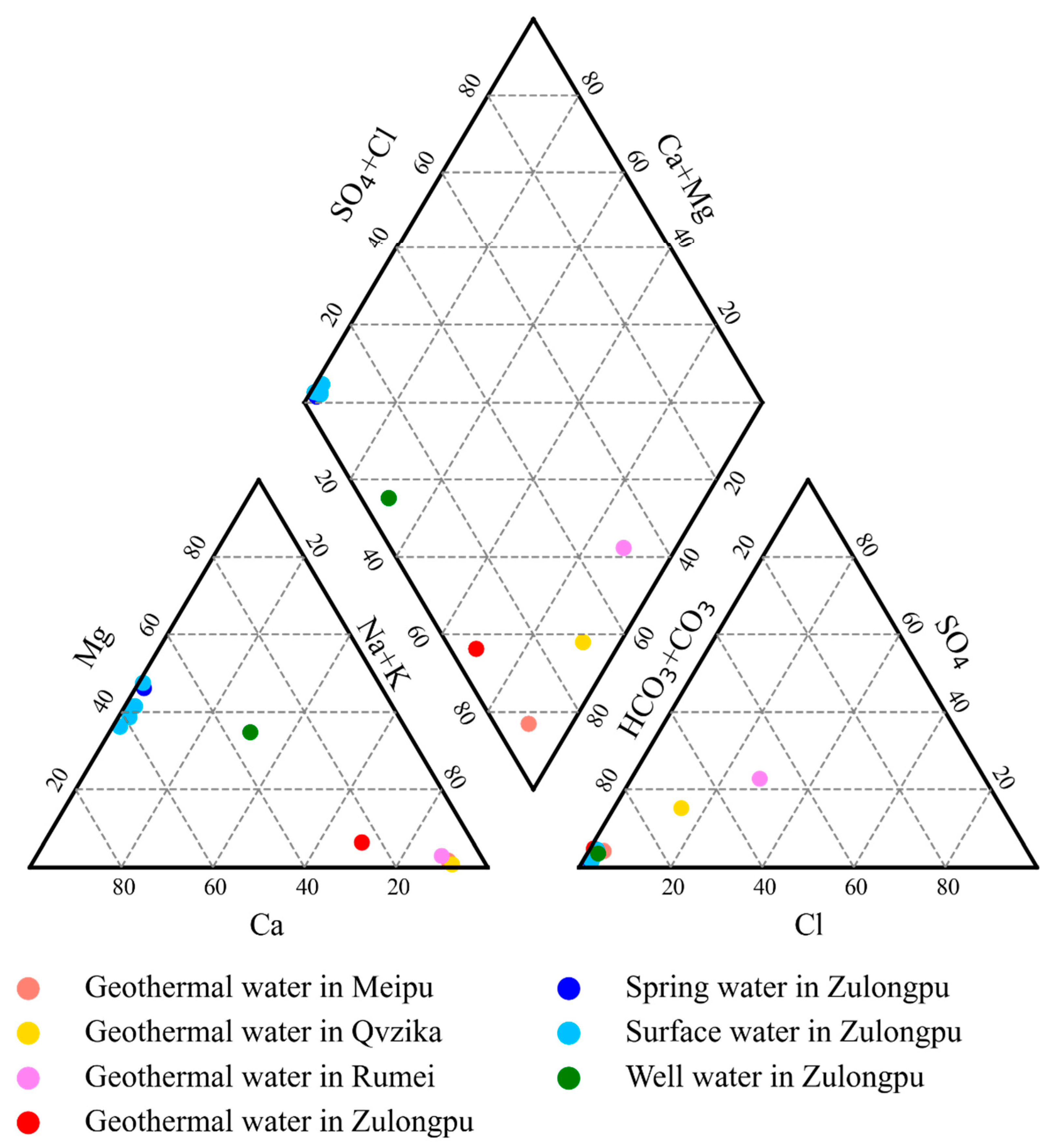
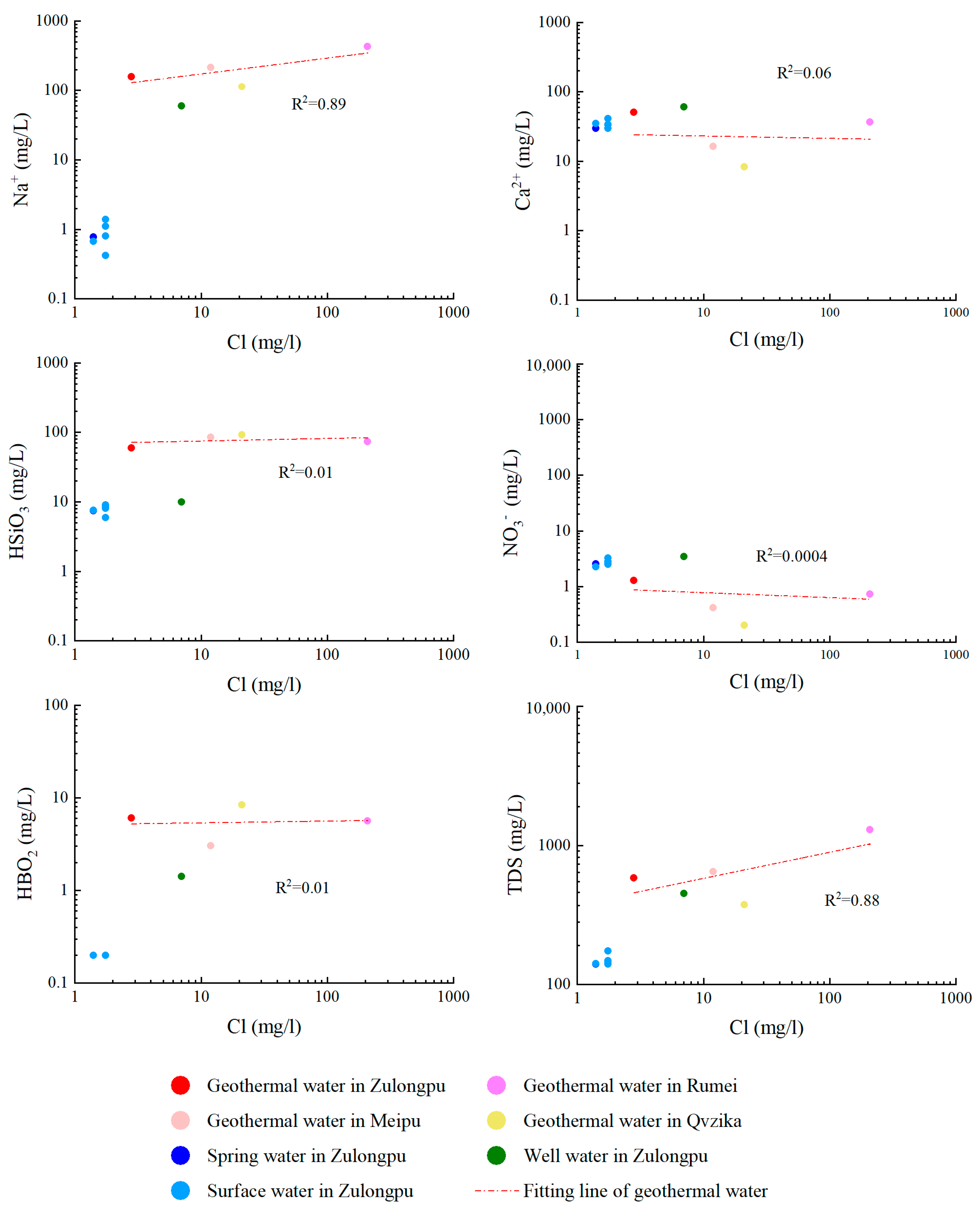
The geothermal water in the Mangkang geothermal field has a geothermal type of HCO3·(Cl)-Na, while the surface water in the geothermal field is of the HCO3-Ca·Mg type. The high HBO2 and Na+ concentrations of the geothermal water indicate long water runoff and strong water–rock interactions.
(2)
Based on mineral–water solubility equilibrium, the hot springs in Meipu village, Qvzika village, Rumei town, and Zulongpu village have reservoir temperatures of 123–130 °C, 121–130 °C, 116–121 °C, and 47 °C, respectively. The silica-enthalpy model revealed that the geothermal water in Meipu village and Rumei town mixes with cold water, with mixing ratios of 63% and 70%, respectively.
(3)
As jointly determined by the geothermal gradients, annual temperature, and reservoir temperature, the circulation depth of the geothermal water in Meipu village, Qvzika village, Rumei town, and Zulongpu village is 3600–4300 m, 3900–4300 m, 3700–4000 m, and 1500 m, respectively.
(4)
The 2H and 18O isotopic analyses revealed the meteoric origin of the geothermal water. Based on the isotopic composition, the geothermal water in Meipu village, Rumei town, and Zulongpu village was found to share very similar recharge elevations (47000–4900 m), while the geothermal water in Qvzika village has the lowest recharge elevation (4400 m).
(5)
The hydrochemical composition of geothermal water varied with the precipitation of chalcedony and dolomite, the absorption of NaX, and the loss of CaX2.
(6)
This study comprehensively analyzed the hydrogeochemical characteristics, temperature, and depth of geothermal reservoirs and the water–rock interaction process in the Mangkang geothermal field in Tibet, China. The conceptual model established based on the analytical results can promote the understanding of the genesis of deep geothermal resources in Tibet. Moreover, this study may serve as a guide for future drilling in the Mangkang geothermal field.

Author Contributions

Conceptualization, Y.L. (Yanguang Liu) and G.W.; methodology, Y.L. (Yuzhong Liao), Y.L. (Yanguang Liu) and G.W.; software, Y.L. (Yuzhong Liao); validation, Y.L. (Yanguang Liu) and G.W.; formal analysis, Y.L. (Yuzhong Liao); investigation, Y.L. (Yuzhong Liao), Y.L. (Yanguang Liu) and T.L.; resources, Y.L. (Yanguang Liu), G.W., F.L., H.G., W.Z.; data curation, Y.L. (Yuzhong Liao); writing—original draft preparation, Y.L. (Yuzhong Liao); writing—review and editing, Y.L. (Yuzhong Liao), Y.L. (Yanguang Liu), G.W., T.L., F.L., S.W., X.Y., H.G., W.Z.; visualization, Y.L. (Yuzhong Liao); supervision, Y.L. (Yanguang Liu) and G.W.; project administration, H.G., G.W., Y.L. (Yanguang Liu); funding acquisition, H.G., G.W., Y.L. (Yanguang Liu). All authors have read and agreed to the published version of the manuscript.

Funding

This research was funded by National Key Research and Development Program of China, grant number 2019YFB1504203; China Geological Survey, grant number DD20221676, DD20190128; National Nature Science Foundation of China, grant number 42272350. The APC was funded by 2019YFB1504203.

Data Availability Statement

All data were presented in the tables of this manuscript.

Acknowledgments

We would like to thank Gui Zhao for his help with the fieldwork. We also thank Chuan Lu and Wenjing Lin for their valuable suggestions and their kind assistance with PHREEQC simulations and diagram preparation.

Conflicts of Interest

The authors declare no conflict of interest.

References

  1. Lin, W.; Wang, G.; Gan, H.; Wang, A.; Yue, G.; Long, X. Heat Generation and Accumulation for Hot Dry Rock Resources in the Igneous Rock Distribution Areas of Southeastern China. Lithosphere 2022, 2021, 2039112. [Google Scholar] [CrossRef]
  2. Lin, W.; Wang, G.; Zhang, S.; Zhao, Z.; Xing, L.; Gan, H.; Tan, X. Heat Aggregation Mechanisms of Hot Dry Rocks Resources in the Gonghe Basin, Northeastern Tibetan Plateau. Acta Geol. Sin. 2021, 95, 1793–1804. [Google Scholar] [CrossRef]
  3. Liu, Y.; Long, X.; Liu, F. Tracer Test and Design Optimization of Doublet System of Carbonate Geothermal Reservoirs. Geothermics 2022, 105, 102533. [Google Scholar] [CrossRef]
  4. Liao, Y.; Liu, Y.; Liu, F.; Wei, S.; Duan, H. Lithospheric Thermal Structure in Jinggangshan City: Implications for High Geothermal Background. Front. Earth Sci. 2022, 10, 854232. [Google Scholar] [CrossRef]
  5. Yu-fei, X.; Ya-bo, Z.; Yuen, D. Geothermal Structure Revealed by Curie Isothermal Surface under Guangdong Province, China. J. Groundw. Sci. Eng. 2021, 9, 114. [Google Scholar] [CrossRef]
  6. Wang, G.L.; Li, J.; Wu, A.M.; Zhang, W.; Hu, Q.Y. A Study of the Thermal Storage Characteristics of Gaoyuzhuang Formation, a New Layer System of Thermal Reservoir in Rongcheng Uplift Area, Hebei Province. Acta Geosci. Sin. 2018, 39, 533–541. [Google Scholar]
  7. Wang, G.L.; Lin, W.J. Main Hydro-Geothermal Systems and Their Genetic Models in China. Acta Geosci. Sin. 2020, 94, 1923–1937. [Google Scholar]
  8. Wang, G.L.; Zhang, W.; Liang, J.Y.; Lin, W.J.; Liu, Z.M.; Wang, W.L. Evaluation of Geothermal Resources Potential in China. Acta Geosci. Sin. 2017, 38, 449–459. [Google Scholar]
  9. Liu, F.; Wang, G.L.; Zhang, W.; Chen, Y.; Tao, L. Using Tough2 Numerical Simulation to Analyse the Geothermal Formation in Guide Basin, China. J. Groundw. Sci. 2020, 8, 328–337. [Google Scholar] [CrossRef]
  10. Feng, M.; Gui-ling, W.; Hong-li, S.; Zhan-xue, S. Indication of Hydrogen and Oxygen Stable Isotopes on the Characteristics and Circulation Patterns of Medium-Low Temperature Geothermal Resources in the Guanzhong Basin, China. J. Groundw. Sci. 2022, 10, 70–86. [Google Scholar] [CrossRef]
  11. Zhou, H.L.; Zhou, X.C.; Su, H.J.; Li, Y.; Liu, F.L.; Ouyang, S.P.; Yan, Y.C.; Bai, R.L. Hydrochemical Characteristics of Earthquake-Related Thermal Springs Along the Weixi-Qiaohou Fault, Southeast Tibet Plateau. Water 2022, 14, 132. [Google Scholar] [CrossRef]
  12. Qi, J.; Li, X.; Xu, M.; Yi, L.; Zhang, Q.; Qin, L.; Li, K. Origin of Saline Springs in Yanjing, Tibet: Hydrochemical and Isotopic Characteristics. Appl. Geochem. 2018, 96, 164–176. [Google Scholar] [CrossRef]
  13. Wang, S.Q.; Lu, C.; Nan, D.; Hu, X.C.; Shao, J.L. Geothermal Resources in Tibet of China: Current Status and Prospective Development. Environ. Earth Sci. 2017, 76, 239. [Google Scholar] [CrossRef]
  14. Zhu, B.; Zhu, L. Geochemical Exploration of Geothermal Fields; Geological Publishing House: Beijing, China, 1992. [Google Scholar]
  15. Guo, Q.H.; Wang, Y.X.; Liu, W. Hydrogeochemistry and Environmental Impact of Geothermal Waters from Yangyi of Tibet, China. J. Volcanol. Geotherm. Res. 2009, 180, 9–20. [Google Scholar] [CrossRef]
  16. Guo, Q.H. Hydrogeochemistry of High-Temperature Geothermal Systems in China: A Review. Appl. Geochem. 2012, 27, 1887–1898. [Google Scholar] [CrossRef]
  17. Tong, W. Geothermals beneath Xizang (Debit) Plateau; Science Press: Beijing, China, 1981. [Google Scholar]
  18. Wang, C.G.; Zheng, M.P. Hydrochemical Characteristics and Evolution of Hot Fluids in the Gudui Geothermal Field in Comei County, Himalayas. Geothermics 2019, 81, 243–258. [Google Scholar] [CrossRef]
  19. Tan, H.B.; Zhang, Y.F.; Zhang, W.J.; Kong, N.; Zhang, Q.; Huang, J.Z. Understanding the Circulation of Geothermal Waters in the Tibetan Plateau Using Oxygen and Hydrogen Stable Isotopes. Appl. Geochem. 2014, 51, 23–32. [Google Scholar] [CrossRef]
  20. Wang, Y.C.; Gu, H.Y.; Li, D.; Lyu, M.; Lu, L.H.; Zuo, Y.H.; Song, R.C. Hydrochemical Characteristics and Genesis Analysis of Geothermal Fluid in the Zhaxikang Geothermal Field in Cuona County, Southern Tibet. Environ. Earth Sci. 2021, 80, 415. [Google Scholar] [CrossRef]
  21. Wang, S. Hydrogeochemical Processes and Genesis Machenism of High-Temperature Geothermal System in Gudui, Tibet. Ph.D Thesis, China University of Geosciences (Beijing), Beijing, China, 2017. [Google Scholar]
  22. Qi, J.; Xv, M.; Zhang, Q.; Qing, L.; Jiang, K.; Qian, L. An Analysis of the Hydrogeochemical Characteristics for the Hot Underwater in Yanjing of Tibet, China. J. Chendu Univ. Technol. 2008, 35, 580–585. [Google Scholar]
  23. Qi, J.; Xu, M.; Zhang, Q.; Qin, L. Research on Circulation Mode for Salt Spring by Isotope Tracing in Yanjin, Tibet. Earth Environ. 2008, 36, 237–244. [Google Scholar]
  24. Wang, X.; Wang, G.L.; Gan, H.N.; Liu, Z.; Nan, D.W. Hydrochemical Characteristics and Evolution of Geothermal Fluids in the Chabu High-Temperature Geothermal System, Southern Tibet. Geofluids 2018, 2018, 8532840. [Google Scholar] [CrossRef] [Green Version]
  25. Özen, T.; Bülbül, A.; Tarcan, G. Reservoir and Hydrogeochemical Characterizations of Geothermal Fields in Salihli, Turkey. J. Asian Earth Sci. 2012, 60, 1–17. [Google Scholar] [CrossRef]
  26. Sun, Z.; Li, X. Studies of Geothermal Waters in Jiangxi Province Using Isotope Techniques. Sci. China Ser. E 2001, 44, 144–150. [Google Scholar] [CrossRef]
  27. Zhang, W.; Wang, G.; Xing, L.; Li, T.; Zhao, J. Geochemical Response of Deep Geothermal Processes in the Litang Region, Western Sichuan. Energy Explor. Exploit. 2019, 37, 626–645. [Google Scholar] [CrossRef]
  28. Chen, Z.; Zhu, L.; Liu, P.; Li, C.; Zhou, Y.; Li, Y.; Xie, H.; Xiang, T. Hydrogeochemical Evolution Mechanism of Carbonate Geothermal Water in Southwest China. Arab. J. Geosci. 2021, 14, 1310. [Google Scholar] [CrossRef]
  29. Bozau, E.; Häußler, S.; van Berk, W. Hydrogeochemical Modelling of Corrosion Effects and Barite Scaling in Deep Geothermal Wells of the North German Basin Using Phreeqc and Phast. Geothermics 2015, 53, 540–547. [Google Scholar] [CrossRef]
  30. Alsemgeest, J.; Auqué, L.F.; Gimeno, M.J. Verification and Comparison of Two Thermodynamic Databases through Conversion to Phreeqc and Multicomponent Geothermometrical Calculations. Geothermics 2021, 91, 102036. [Google Scholar] [CrossRef]
  31. Zuo, Q.; Ye, T.; Feng, Y.; Ge, Z.; Wang, Y. Spatial Database of Serial Suite-Tectonic Map-Sheets of Mainland China (1:250,000). Geol. China 2018, 45, 1–26. [Google Scholar] [CrossRef]
  32. Tian, Y.; Yu, C.Q.; Luo, K.L.; Zha, X.J.; Wu, J.S.; Zhang, X.Z.; Ni, R.X. Hydrochemical Characteristics and Element Contents of Natural Waters in Tibet, China. J. Geogr. Sci. 2015, 25, 669–686. [Google Scholar] [CrossRef]
  33. Liao, Y.; Liu, Y.; Liu, F.; Lu, C.; Zhao, G. Genetic Mechanism of Geothermal Resources in the Qutan and Reshuizhou Geothermal Fields, Jiangxi Province, China: Evidence from Hydrogeochemical Characteristics of Geothermal Water. Lithosphere 2022, 2021, 9778217. [Google Scholar] [CrossRef]
  34. Lang, X.; Lin, W.; Liu, Z.; Xing, L.; Wang, G. Hydrochemical Characteristics of Geothermal Wate in Guide Basin. Earth Sci. 2016, 41, 1723–1734. [Google Scholar]
  35. Mondal, N.C.; Singh, V.P.; Singh, V.S.; Saxena, V.K. Determining the Interaction between Groundwater and Saline Water through Groundwater Major Ions Chemistry. J. Hydrol. 2010, 388, 100–111. [Google Scholar] [CrossRef]
  36. Luo, B. The Chemical Characteristics and Geological Significance of the Formation Water of Mesozoic in Zhenjing Area of Ordos Basin. Inn. Mong. Petrochem. Ind. 2014, 5, 36–39. [Google Scholar]
  37. Hao, Y. Study on Chemistry Characteristic of Groundwater and Formation Mechanism in Akesu Area. Master’s Thesis, Tarim University, Aral Shehri, China, 2010. [Google Scholar]
  38. Pang, Z.-H.; Reed, M. Theoretical Chemical Thermometry on Geothermal Waters: Problems and Methods. Geochim. Cosmochim. Acta 1998, 62, 1083–1091. [Google Scholar] [CrossRef]
  39. Ren, Z. A Study of the Characteristics and Genesis of the Hot Spring and Salt Springs in the Langping Area of Yunan. Master’s Thesis, China Univerisity of Geosciences, Beijing, China, 2016. [Google Scholar]
  40. Spycher, N.; Peiffer, L.; Sonnenthal, E.L.; Saldi, G.; Reed, M.H.; Kennedy, B.M. Integrated Multicomponent Solute Geothermometry. Geothermics 2014, 51, 113–123. [Google Scholar] [CrossRef]
  41. Zhu, X.; Wang, G.; Wang, X.; Qi, S.; Ma, F.; Zhang, W.; Zhang, H. Hydrogeochemical and Isotopic Analyses of Deep Geothermal Fluids in the Wumishan Formation in Xiong’an New Area, China. Lithosphere 2022, 2021, 2576752. [Google Scholar] [CrossRef]
  42. Zhao, J.; Zhang, W.; Zhang, H.; Qu, Z.; Li, M.; Yue, G. Hydrogeochemical Characteristics and Genesis of the Geothermal Fields in Batang of Sichuan. Hydrogeol. Engenerring Geol. 2019, 46, 81–89. [Google Scholar]
  43. Reed, M.; Spycher, N. Calculation of Ph and Mineral Equilibria in Hydrothermal Waters with Application to Geothermometry and Studies of Boiling and Dilution. Geochim. Cosmochim. Acta 1984, 48, 1479–1492. [Google Scholar] [CrossRef]
  44. Arnórsson, S. Isotopic and Chemical Techniques in Geothermal Exploration, Development and Use; International Atomic Energy Agency: Vienna, Austria, 2000; p. 351. [Google Scholar]
  45. Arnorsson, S. Application of Silica Geothermometer in Low-Temperature Hydrothermal Areas in Iceland. Am. J. Sci. 1975, 275. [Google Scholar] [CrossRef]
  46. Fournier, R.O.; Rowe, J.J. Estimation of Underground Temperatures from the Silica Content of Water from Hot Springs and Wet-Steam Wells. Amer. J. Sci. 1966, 264, 685–697. [Google Scholar] [CrossRef]
  47. Fournier, R.O.; Truesdell, A.H. Chemical Indicators of Subsurface Temperature Applied to Hot Spring Waters of Yellowstone National Park, Wyoming, U.S.A. Geothermics 1970, 2, 529–535. [Google Scholar] [CrossRef]
  48. Fournier, R.O.; Truesdell, A.H. An Empirical Na-K-Ca Geothermometer for Natural Waters. Geochim. Cosmochim. Acta 1973, 37, 1255–1275. [Google Scholar] [CrossRef]
  49. Fournier, R.O.; Truesdell, A.H. Geochemical Indicators of Subsurface Temperature. Part Ii. Estimation of Temperature and Fraction of Hot Water Mixed with Cold Water. J. Res. U.S. Geol. Surv. 1974, 2, 259–262. [Google Scholar]
  50. Schmitt, M.J.; Dehope, W.J.; Ferguson, P.E.; Hart, S.L.; Matranga, V.A. Improved Silica Geothermometer for Low Temperature Geothermal Resource Assessment. Monthly Progress Report, March–April 1983; Arizona Solar Energy Commission, Phoenix: Scottsdale, AZ, USA, 1983.
  51. Fournier, R.O. Chemical Geothermometers and Mixing Models for Geothermal Systems. Geothermics 1977, 5, 41–50. [Google Scholar] [CrossRef]
  52. Chimeddorj, B.; Munkhbat, D.; Altanbaatar, B.; Dolgorjav, O.; Oyuntsetseg, B. Hydrogeochemical Characteristics and Geothermometry of Hot Springs in the Altai Region, Mongolia. Geochem. Explor. Environ. Anal. 2021, 21, geochem2021-016. [Google Scholar] [CrossRef]
  53. Ahmad, M.; Akram, W.; Ahmad, N.; Tasneem, M.A.; Rafiq, M.; Latif, Z. Assessment of Reservoir Temperatures of Thermal Springs of the Northern Areas of Pakistan by Chemical and Isotope Geothermometry. Geothermics 2002, 31, 613–631. [Google Scholar] [CrossRef]
  54. Keenan, J.H.; Keyes, F.G.; Hill, P.G.; Moore, J.G. Steam Tables—Thermodynamic Properties of Water Including Vapor, Liquid, and Solid Phases (International Edition—Metric Units); Wiley: New York, NY, USA, 1969; p. 89. [Google Scholar]
  55. Truesdell, A.H.; Fournier, R.O. Procedure for Estimating the Temperature of a Hot-Water Component in a Mixed Water by Using a Plot of Dissolved Silica Versus Enthalpy. J. Res. U.S. Geol. Surv. 1977, 5, 49–52. [Google Scholar]
  56. Morey, G.; Fournier, R.; Rowe, J. The Solubility of Quartz in Water in the Temperature Interval from 25 to 300 °C. Geochim. Cosmochim. Acta 1962, 26, 1029–1043. [Google Scholar] [CrossRef]
  57. Giggenbach, W.F. Geothermal Solute Equilibria. Derivation of Na-K-Mg-Ca Geoindicators. Geochim. Cosmochim. Acta 1988, 52, 2749–2765. [Google Scholar] [CrossRef]
  58. Das, P.; Maya, K.; Padmalal, D. Hydrochemistry, Geothermometry and Origin of the Low Temperature Thermal Springs of South Konkan Region, India. Geothermics 2020, 90, 101997. [Google Scholar] [CrossRef]
  59. Yu, J.; Zhang, H.; Yu, F.; Liu, D. Oxygen Isotopic Composition of Meteoric Water in the Eastern Part of Xizang. Geochemica 1980, 2, 113–121. [Google Scholar] [CrossRef]
  60. Craig, H. Isotopic Variations in Meteoric Waters. Science 1961, 133, 1702–1703. [Google Scholar] [CrossRef] [PubMed]
  61. Qin, X.W.; Ma, H.Z.; Zhang, X.Y.; Cheng, H.D.; Han, J.B.; Li, Y.S.; Miao, W.L.; Hai, Q.Y. Geochemical Constraints on the Origin and Evolution of Spring Waters in the Changdu-Lanping-Simao Basin, Southwestern China. Acta Geol. Sin. 2019, 93, 1097–1112. [Google Scholar] [CrossRef]
Figure 1. (a) Schematic tectonic map of the Mangkang geothermal field (modified after Zuo, et al. [31] and Wang, et al. [13]). F1: Sivarick A-type subduction zone; F2: Brahmaputra suture zone; F3: Gonghu–Nujiang suture zone; F4: Shuanghu–Lancang suture zone; F5: Yanghu–Jinshajiang suture zone; I: Gondwanaland; I1: Indian terrane, I2: Himalayan terrane; I3: Gangdisi–Nianqingtanggula terrane; II: Pancathaysia; II1: South Qiangtang–Zuokong terrane, II2: Qamdu–Simao terrane, II3: Bayan Har terrane, II4: Dege–Zhongdian terrane. (b) Schematic geological map showing the sample locations (triangles). Fm1: Laoran–Nagu fault; Fm2: Zhuka–Qitangniuchang fault; Fm3: Beiligong–Calixueshan fault.
Water 14 04041 g001
Figure 2. Geological sections of the Mangkang geothermal field (modified after Zuo, et al. [31] and Qi, et al. [12]). The locations of the sections are shown in Figure 1b. (a) Geological cross-section of ‘A-B-C’ whose location in the study area is shown in Figure 1b. This section is distributed to the north of Mangkang geothermal field, with three hot springs (Rumei, Zulongpu and Meipu springs) located along it. The striking direction of section ‘A-B’ is nearly west–east (5°), while that of ‘B-C’ is 63°; (b) Geological cross-section of ‘D-E’ is located at the south edge of Mangkang geothermal field, with an orientation of ~15°. Qvzika hot spring is located at the start point (endpoint D) of this section.
Water 14 04041 g002
Figure 3. Theoretical framework of this research.
Water 14 04041 g003
Figure 4. Schoeller–Berkalof diagram of water samples from the Mangkang area.
Water 14 04041 g004
Figure 5. Piper diagram of the water samples from the Mangkang geothermal field.
Water 14 04041 g005
Figure 6. Relationships of Cl concentration vs. Na+, Ca2+, NO3, H2SiO3, and HBO2 concentrations and TDS content.
Water 14 04041 g006
Figure 7. SI-T plots for minerals of the Mangkang geothermal field. The trendline of K-feldspar overlaps the equilibrium line (SI = 0).
Water 14 04041 g007
Figure 8. Dissolved silica-enthalpy plot of the Mangkang geothermal water.
Water 14 04041 g008
Figure 9. Piper diagram of water samples from the Mangkang geothermal field. The location of spring water in Zulongpu overlaps with that of surface water in Zulongpu.
Water 14 04041 g009
Figure 10. δ2H vs. δ18O values of water samples from the Mangkang geothermal field (The global meteoric water line refers to Craig [60]).
Water 14 04041 g010
Figure 11. Conceptual model of geothermal water (hot spring) in the Mangkang geothermal field (modified after Qi, et al. [12]). (a) Geological cross-section of ‘A-B-C’ whose location in the study area is shown in Figure 1b. This section is located to the north of the Mangkang geothermal field, with three hot springs (Rumei, Zulongpu and Meipu springs) along it. The striking direction of section ‘A-B’ is nearly west–east (5°), while that of ‘B-C’ is 63°; (b) Geological cross-section of ‘D-E’ is located at the south edge of the Mangkang geothermal field, with an orientation of ~15°. Qvzika hot spring is located at the start point (endpoint D) of this section.
Water 14 04041 g011
Table 1. Locations of sampling points in the Mangkang geothermal field.
Sample No.Sample PropertyLogtitudeLatitudeAltitude (m)
ZLPWQ001Geothermal water in Zulongpu98°37′04″29°37′57″3934
RMZWQ001Geothermal water in Rumei98°22′12″29°36′41″3159
QZKWQ001Geothermal water in Qvzika98°36′20″29°05′33″2533
MPWQ001Geothermal water in Meipu98°55′03″29°44′38″2860
MKQ001Spring water in Zulongpu98°37′55″29°37′26″3996
MKDW001Well water in Zulongpu98°35′00″29°35′35″3641
MKDB001Surface water in Zulongpu98°37′05″29°37′58″3932
MKDB00598°37′59″29°37′00″3970
MKSY-198°38′00″29°37′00″3986
MKSY-298°38′00″29°37′12″3981
MKSY-398°37′30″29°37′38″3981
Table 2. Geochemical compositions of water samples from the Mangkang geothermal field.
SampleKNaCaMgHCO3SO42−ClFNO₃CO₃2HSiO3
No.mg/Lmg/Lmg/Lmg/Lmg/Lmg/Lmg/Lmg/Lmg/Lmg/Lmg/L
ZLPWQ0019.33159.350.267.95572.7232.81.861.29059.72
RMZWQ0015.79431.936.557.76640.3234.3208.71.690.72073.64
QZKWQ0015.89112.78.210.49175.830.0221.0114.3<0.2017.892.46
MPWQ00110.55213.316.352.2559821.4811.93.290.41084.41
MKQ0010.690.7829.4315.67163.72.451.40.12.5407.46
MKDW0013.5359.2659.8836.2949915.0870.53.4409.94
MKDB0010.641.133.714.92172.24.051.750.132.8108.09
MKDB0050.450.6734.9312.24137.75.141.40.112.2611.97.55
MKSY-10.811.3840.8516.112004.781.750.142.5409.04
MKSY-20.30.4229.6416.39163.72.181.750.113.2305.92
MKSY-30.480.833.2914.51168.53.961.750.122.4908.26
SampleHBO2TDSpHT*pH*Eh*CD*TDSECBEWT
No.mg/Lmg/Lmg/L°C mVμS/cmppmm%
ZLPWQ0016.045837.6418.10 71.00 78839339341.27 HCO3-Na
RMZWQ0015.5912997.8443.00 6.8310165282731590.16 HCO3·Cl-Na
QZKWQ0013.023758.3367.50 7.56−3849325325330.55 HCO3-Na
MPWQ0018.436487.8249.10 6.87 88674332860−0.98 HCO3-Na
MKQ001<0.201408.178.20 8.11−622051023996−0.18 HCO3-Ca·Mg
MKDW0011.424497.8610.80 −3361330636413641−0.75 HCO3-Ca·Na
MKDB001<0.201488.0311.78.48−832161083932−0.50 HCO3-Ca·Mg
MKDB005<0.201418.3314.20 8.52−862021013970−1.24 HCO3-Ca·Mg
MKSY-1<0.20173812.20 8.07−602381203986−0.43 HCO3-Ca·Mg
MKSY-2<0.201398.067.90 8.01−5520110039810.35 HCO3-Ca·Mg
MKSY-3<0.201458.1317.80 8.43−832101053981−0.86 HCO3-Ca·Mg
Note: T*, pH*, Eh*, and CD* denote the orifice temperature, pH value, Eh value, and conductivity of water samples measured on site, respectively; E denotes elevation; CBE denotes charge-balance error, and WT denotes water type.
Table 3. γNa/γCl, γCl/γHCO3, and γCl/γCa ratios of water samples from the Mangkang geothermal field.
SampleγNa/γClγCl/γHCO3γCl/γCa
MKWQ00156.890.0050.06
RMZWQ0012.070.3265.71
QZKWQ0015.360.1092.56
MPWQ00117.920.020.73
Table 4. Reservoir temperatures of the Mangkang geothermal field.
SampleTf (°C)Tm-w (°C)Tc (°C)TNa-k-Ca (°C)Ts-e (°C)Mixing Ratio (%)
MPWQ00149.1123–13071.8150.411263
QZKWQ00167.5121–13076.5148.48522
RMZWQ00143116–12165.183.611570
ZLPWQ00118.14755.381//
Note: Tf denotes the orifice temperature of spring water measured in the field; Tm-w denotes the temperature estimated according to the solubility equilibrium of the mineral–geothermal water system; Tc denotes the temperature determined using a chalcedony geothermometer [51]. TK-Na-Ca denotes the temperature obtained using a K-Na-Ca geothermometer [48]. Ts-e denotes the reservoir temperature determined using the silica-enthalpy model [17]. The temperatures in bold are reasonable and applied in this study.
Table 5. Enthalpies of liquid water and the corresponding quartz solubilities.
TemperaturePressureEnthalpySiO2 Content
(°C)(bars)(cal/g)(mg/L)
500.125013.5
750.397526.6
1001.01100.148
1252.32125.480
1504.76151125
1758.92177185
20015.54203.6265
22525.48230.9365
25039.73259.2486
Note: The temperature and pressure were appropriate for coexisting steam and liquid water [54]. Quartz solubilities make reference to Morey, et al. [56] and Fournier, et al. [49].
Table 6. The calculated depths of geothermal reservoirs.
SampleD (m)t1 (°C)t2 (°C)G (°C/100 m)h (m)
MPWQ0013600–4300112–1303320
QZKWQ0013900–4300121–1303320
RMZWQ0013700–4000115–1213320
ZLPWQ001~1500473320
Table 7. δ2H, δ18O, and δ3H values of water samples from the study area.
SampleSample Propertyδ2HVSMOW
(‰)
δ18OVSMOW
(‰)
Elevation
(m)
Recharge Elevation (m)3H
(Tu)
MPWQ001Geothermal water in Meipu−157−20.428604827<1.0
QZKWQ001Geothermal water in Qvzika−145−19.325334442<1.0
RMZWQ001Geothermal water in Rumei−157−20.131594750<1.0
ZLPWQ001Geothermal water in Zulongpu−158−20.339344865<1.0
MKQ001Spring water in Zulongpu−149−193996
MKDB001Surface water in Zulongpu−141−18.23932
MKDB005Surface water in Zulongpu−144−18.73970
MKSY-1Surface water in Zulongpu−142−18.23986
MKSY-2Surface water in Zulongpu−146−18.83981
MKSY-3Surface water in Zulongpu−145−18.73981
26 *Surface water in Qvzika−109−14.7
Note: ‘*’ denotes the samples from [12].
Table 8. Inverse model of PHREEQC simulation.
AreaMeipuRumeiZulongpu
Mole transfer of anhydrite//1.6 × 10−4
Mole transfer of calcite//3.73 × 10−3
Mole transfer of chalcedony−7.91 × 10⁻⁴−4.76 × 10⁻³−5.45 × 10⁻⁴
Mole transfer of dolomite−2.83 × 10⁻³−5.72 × 10⁻²−8.39 × 10⁻⁴
Mole transfer of fluorite6.34 × 10−5−2.48 × 10−44.25 × 10−5
Mole transfer of gibbsite−1.59 × 10−41.25 × 10−3−2.8 × 10⁻⁴
Mole transfer of NaX8.51 × 10−31.53 × 10−26.84 × 10−3
Mole transfer of CaX2−4.26 × 10⁻³−7.55 × 10⁻³−3.42 × 10⁻³
Mole transfer of K-feldspar1.59 × 10−4−1.25 × 10−32.8 × 10−4
Mole transfer of CO2/−1.2 × 10−1/
Mole transfer of NH4X/−2.7 × 10−4/
Note: mole transfer in mmol/kg (millimoles per kilogram water), with positive values indicating dissolution and negative values implying precipitation. “/” denotes a mineral that is not involved in the reaction.
Publisher’s Note: MDPI stays neutral with regard to jurisdictional claims in published maps and institutional affiliations.

