
Water Reservoirs in Plans to Improve Navigability of the Lower Section of the Vistula


1
State Water Holding Polish Waters, Żelazna 59a, 00-848 Warsaw, Poland
2
Doctoral School, University of Silesia in Katowice, Bankowa 12, 40-007 Katowice, Poland
3
Faculty of Transport Engineering and Economics, Maritime University of Szczecin, H. Pobożnego 11, 70-500 Szczecin, Poland
4
Hydro and Environmental Engineering Installations, Faculty of Building Services, Warsaw University of Technology, Nowowiejska 20, 00-653 Warsaw, Poland
*
Author to whom correspondence should be addressed.
Water 2022, 14(24), 4042; https://doi.org/10.3390/w14244042
Submission received: 18 October 2022
/
Revised: 1 December 2022
/
Accepted: 8 December 2022
/
Published: 11 December 2022
(This article belongs to the Special Issue New Challenges in the Planning, Design, Construction and Operation of Reservoirs in the Context of Climate Change)
Abstract
:Retention reservoirs are one of the basic elements of water management. Multifunctional, they are used for flood protection, drought prevention and other purposes. Water reservoirs can also play a fundamental role in improving navigability on the lower section of the Vistula River from the Włocławek barrage to the mouth of the Gdansk Bay. Their implementation is a determinant for the possibility of restoring the economic role of the river in question. Therefore, the purpose of this research was to determine the current navigation conditions and the state of the regulatory buildings on the Lower Vistula. The investments necessary to achieve international parameters of the waterway were also determined, together with the calculation of financial benefits related to their implementation. This was possible based on the conducted bathymetric measurements, spatial analyses, economic calculations and queries of the obtained studies. It was established that fairway depths of 1.4 m are ensured for 180 days per year on average. On the other hand, the construction of five barrages (Siarzewo, Solec Kujawski, Chełmno, Grudziądz and Gniew) will make it possible to achieve at least a navigability class IV (international) on the section of the Vistula River waterway. In addition, the barrages will enable the retention of 1.2 billion m3 of water and will be associated with financial benefits such as shipping use, flood protection and counteracting the effects of drought. On this account, annual revenues may amount to approximately PLN 3.5 billion. This shows that the construction of the reservoirs is profitable, and the proposed solutions should be implemented in the context of sustainable water management and adaptation to climate change.
1. Introduction
Water reservoir implementation is often associated with a specific need for increased retention [1]. Each hydrotechnical structure is created in response to social, economic, environmental and other conditions. These conditions determine the functions that the reservoir is to fulfill. Its purpose is determined on such a basis, which is the starting point in the development of the assumptions for design or a functional and operational program in the case of the facility being implemented in the “design and build” mode. The purpose of a properly defined hydrotechnical structure enables an appropriate design and the construction of a barrage and the associated retention reservoir. In the case of such facilities, multifunctionality is visible. Therefore, it results from the needs catalogue, due to which the decision to build a given facility is made. Despite multitasking, the dominant function of the reservoir is usually distinguished. The primary role of most reservoirs in Poland is generally to protect against floods, implemented by reducing (so-called flattening) the flood wave and controlling its size [2], and the winter sheet on sections of lowland rivers (ensuring adequate depths for the operation of icebreakers).
In the case of the Vistula River waterway, the existing and planned dam reservoirs serve inland navigation and other important economic functions. These functions include water retention, among others, counteracting the effects of drought, ensuring water supply for its industrial and municipal use, maintaining proper water and soil relations and irrigating the land necessary for agriculture and forestry, using the energy of flowing water to produce electricity, as well as creating conditions for water tourism and recreation, and the operation of various facilities related to the navigable route. Therefore, the infrastructural investments on the inland waterways are characterized by the high productivity of the incurred outlays [3]. For example, the implementation of the entire Polish section of the E-40 waterway from the seaport in Gdansk to the Polish-Belarusian border in Brest (via Warsaw), together with the way to the seaport in Elbląg is economically profitable. According to the cost-benefit analysis results, each PLN 1 spent should generate a profit of PLN 2.81 [4,5].
The development of inland waterway transport is part of the transport policy of the European Union. Accordingly, inland navigation should—where it is geographically feasible—significantly contribute to an efficient multimodal transport system. It also has great potential for land connections with seaports, supplying important industrial centers, urban agglomerations and urban passenger transport [6]. The development of inland waterway transport will contribute to reducing road congestion and pollutant emissions, increase safety and, above all, create a fully sustainable European transport system [7]. The increased importance of inland navigation in cargo transport is also expected to reduce greenhouse gases in the atmosphere, which is in line with the provisions of the Green Deal Program for 2021–2027 [8]. According to the adopted principles, projects are also planned in Poland to develop inland waterways, one of the priority elements of which is to significantly improve the navigation conditions on the waterway of the Vistula River [9].
Historical conditions show that the Vistula was the economic axis of Poland, and in the 16th century and at the beginning of the 17th century, it was the most navigable river in Europe. Annually, more than 0.25 million tons of cargo was transported by the Vistula to the seaport in Gdansk [10]. Currently, the Vistula River waterway is an untapped transport potential, used mainly for the local transport of aggregate, single (occasional) deliveries of oversize cargo and water tourism. A solution that may reverse this situation is the construction of the Lower Vistula cascade. The history of the plans for its implementations is 85 years old:
- Right after World War II, the “Cascade of the Lower Vistula” program was prepared, under which the only barrage in Włocławek was built on the lower section of the Vistula, and preparations for the construction site for the construction of another barrage in Ciechocinek were started;
- In the years 1968–1971, the “Project of Comprehensive Development of the Water System of the Vistula River” was developed;
- At the end of the 1970s, the “Comprehensive Program for the Development and Use of the Vistula” was prepared (the so-called “Vistula Program”) [10].
Therefore, the interest in this area and its management was high. In addition to issues related to water management (mainly flood protection), technical and economic aspects (primarily hydropower), natural, cultural and recreational aspects were also taken into account. The entire plans could not be implemented due to insufficient justification for many of the investments, lack of financial resources and insufficient resources in Polish enterprises [10].
However, in recent years there has been a slightly different approach to the size of the dams, and thus the planning of the size of the retention reservoirs. The assumptions for the development of the Lower Vistula assume the achievement of the intended goals while maintaining the river nature of the Vistula in this section and limiting the capacity of the reservoirs to the necessary minimum [11]. These innovative assumptions boil down to the fact that when determining the optimal location of barrages, the following factor is taken into account: maintaining the normal damming level not higher than the existing water table in the cross-section of the barrage, as a result of which conditions similar to the current conditions will be ensured during flood flows (there will be no clear damming up) [11]. At the same time, when determining the location of a given barrage, multi-faceted analysis plays an important role, where the technical, environmental, transport, economic, social, and functional criteria are taken into account [4]. It is worth adding that when studying ecological factors, it is necessary to consider the impact of navigation on the river ecosystems, determining the spatial distribution, potential risks and drivers of river health, but also to present the programs for ecological conservation and sustainable river management based on detailed studies [12].
Therefore, in this article, the authors considered the factors that allow for the overturning of regular inland navigation and the economic role on the lower section of the Vistula from the Włocławek barrage to the mouth of the Gdansk Bay. The starting point was to determine the existing possibilities of inland waterway transport (mainly the observed fairway depths and the condition of the hydrotechnical structures) and the assumed future parameters of the navigable route, taking into account other essential needs and requirements, including those concerning flood protection and drought mitigation.
The main aim of this study was to present the currently planned and possible future projects, the effective implementation of which should affect the achievement of operational parameters on the Lower Vistula waterway, favorable to regular inland navigation and the achievement of international parameters of the navigable route. The activities presented include the reconstruction of the regulatory structure and the construction of new barrages, including the Siarzewo barrage, currently undergoing pre-design work, which will simultaneously increase flood safety and develop retention essential for preventing drought.
In this study, the issue of creating new retention reservoirs for the purpose of improving the navigability of the lower section of the Vistula, as well as the conditions and technical aspects of their construction, were correlated with other elements related to their subsequent use. The planned facilities are to be multifunctional (enabling the achievement of many goals important for rational water management), so the issue of their functionality was presented by determining the measurable (quantified) effects of their implementation. In this regard, special attention was paid to the role of the planned reservoirs in the aspect of the recently observed climate changes, focusing on retention possibilities (indicating the assumed amount of stored water), which translate into benefits related to, among other things, flood protection and reducing the effects of drought. Protection against flooding requires both the creation of flood retention and the provision of appropriate depths throughout the entire section of the river under consideration. On the other hand, the issue of counteracting the effects of drought was considered necessary in the context of the number of available water resources and the location of the research area among the areas at risk of hydrological drought. Therefore, it was assumed that planning appropriate activities for the purpose of improving navigation conditions on the Lower Vistula waterway downstream from the Włocławek barrage would also be of great importance for the improvement of water relations in the areas adjacent to the planned retention reservoirs.
2. Materials and Methods
2.1. Study Area
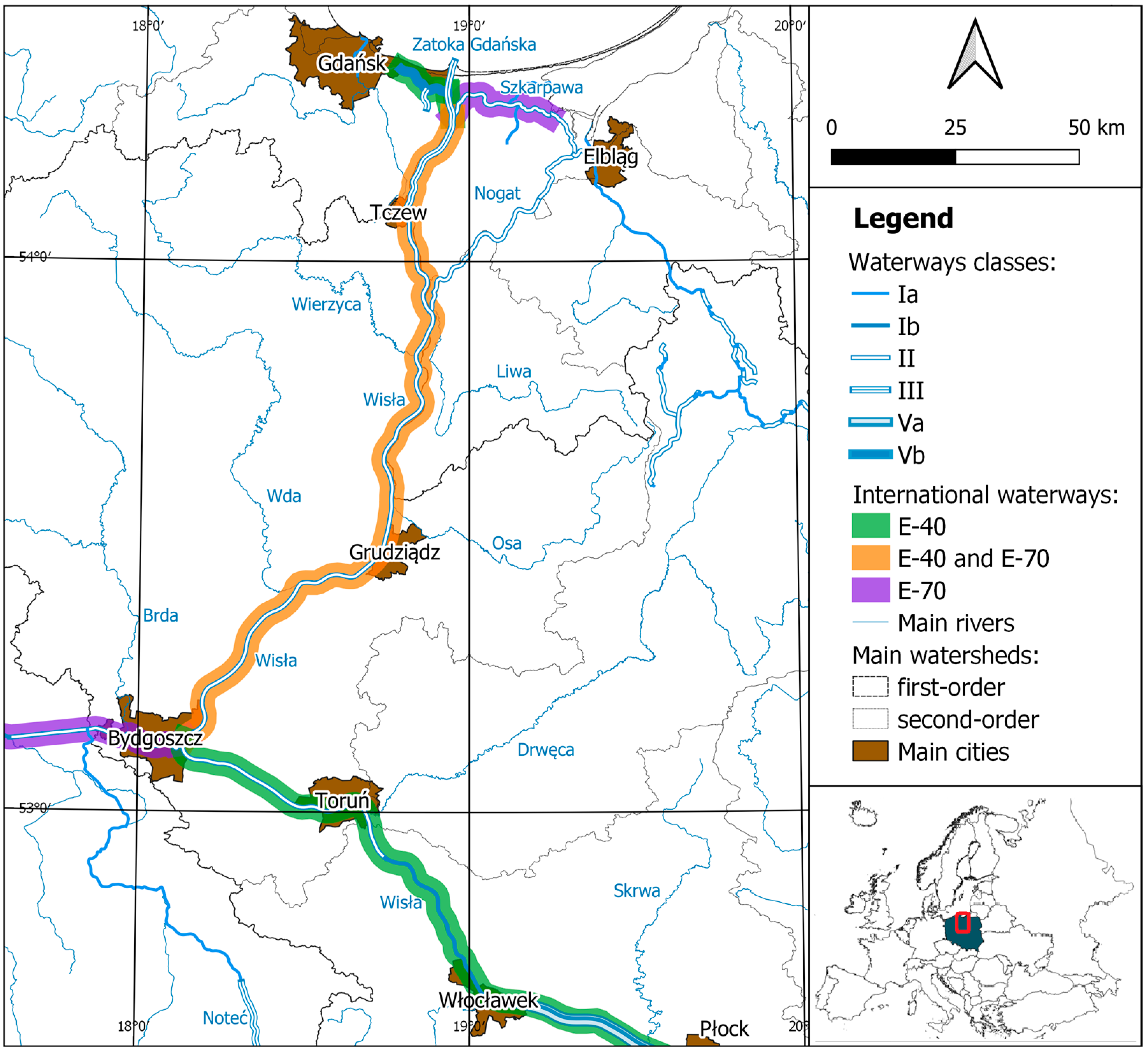
The analyses covered the section of the Vistula River from the Włocławek barrage to the estuary to the Gdansk Bay. As a result of the regulations enforced in Poland [13], this area has been classified as an inland waterway, divided into sections of various classes:
- From the Włocławek barrage to the mouth of the Tążyna River (km 674 + 850–718 + 000)—Ib;
- From the mouth of the Tążyna River to the town of Tczew (km 718 + 000–910 + 000)—II;
- From the town of Tczew to the border with internal sea waters (km 910 + 000–942 + 300)—III (Figure 1).
The considered fragment of the Vistula River waterway is connected (Figure 1) mainly with:
- The seaport in Gdansk through the Martwa Wisła (km 0 + 000–11 + 500)—Vb;
- The seaport in Elbląg through the Szkarpawa (km 0 + 000–25 + 400) or the Nogat (km 0 + 000–62 + 000) and the Jagiellonian Canal (km 0 + 000–5 + 900)—II;
- The Oder and Western European waterways through the Vistula-Oder link (Brda, Bydgoszcz Canal, Noteć and Warta)—section of the Noteć from the junction with the Bydgoszcz Canal to the mouth of the Drawa Ib, and the remaining II,
- The Włocławek reservoir—Va, as well as the section of the Vistula River located upstream of it—Ib.
In addition, there are also two out of three European navigation routes marked by the territory of Poland on the Vistula (Figure 1): E-40—connecting the Baltic Sea in Gdansk and the Black Sea in Odesa and delineated along the Vistula from Gdansk to Warsaw, the Żerań Canal, the Narew and the Bug rivers to the Belarusian border in Brest and E-70—running from the Netherlands to Lithuania, and through Poland along the Odra, Warta, Noteć, Bydgoszcz Canal and Brda as well as the Vistula and Nogat or Szkarpawa to the Vistula Lagoon [15].
For individual classes of waterways, the specific operational parameters have been defined, i.e., the minimum dimensions of the navigable route (Table 1) and locks, as well as the clearance height under bridges, pipelines and other devices crossing the waterway.
Regarding hydrology, the analyzed area is entirely related to the Baltic Sea catchment area, the largest hydrographic unit of which is the Vistula basin, with an area of 194,424 km2 [16]. The total length of the Vistula River is 1047 km, and an average of 34 km3 of water is annually discharged into the Gdansk Bay; the observed maximum runoff is 50.8 km3 (wet 1975) and the minimum runoff is 20.5 km3 (dry 1952) [17]. In the Tczew water gauge cross-section (the last with hydrological measurements), the average flow from the multi-year period 1971–2014 was calculated at 1042 m3/s [16]. However, the maximum recorded flow in the post-war period was 6490 m3/s and the minimum was 264 m3/s [17]. The Vistula has a complex hydrological system (snow and rain), which is shaped mainly in the upper part of the catchment area. Here, the riverbed is supplied mainly due to the spring snow thaw and summer rainfall, and the level of flooding is higher than the fluvial flood.
2.2. Data
The research was divided into two main parts: first, concerning the existing parameters of the Vistula River waterway to the Włocławek barrage to the mouth of the Gdansk Bay; second, the state of the regulatory buildings, and focusing on the analyses of the water reservoirs planned for construction.
Unpublished data from the Regional Water Management Authority in Gdansk State Water Holding Polish Waters were used to calculate the existing navigation conditions. These data were collected on ships in the form of regular sonar soundings (bathymetric measurements) from the navigable route in 2019–2021 [18]. Based on the data, places with limited fairway depths (the smallest depth of the navigable route determined based on fieldwork) were selected along the entire analyzed section. These places were compared with the hydrological data provided by the Institute of Meteorology and Water Management, National Research Institute [19], including information about the situation in the lower avantport of the lock in Włocławek from the daily monitoring carried out by the Regional Water Management Authority in Warsaw State Water Holding Polish Waters [20] and the designated places with ice jams, as specified in the “instructions for conducting winter flood protection on the Lower Vistula” [21]. However, to evaluate the condition of the hydrotechnical buildings, program [22] and strategic documents were assessed using relevant information developed in September 2021 [23,24].
In terms of the planned water reservoirs, the primary source of information was the “feasibility study for the comprehensive development of international waterways: E-40 for the Vistula River in the section from Gdansk to Warsaw, E-40 from Warsaw to the Poland-Belarus (Brest) border and E-70 on the section from the Vistula to the Vistula Lagoon (Elbląg)” [5]. The technical analyses presented indicated the planned locations of barrages on the section of the Vistula River from the barrage in Włocławek to the estuary to the Gdansk Bay. Based on this and the accepted ordinates of the normal water level in the reservoirs in question, calculations were made of the potential capacities of all objects and the range of their occurrence was determined.
In turn, the cost-benefit analysis prepared in the indicated document was the basis for calculating the quantified economic results of water retention, particularly regarding the development of inland water transport, increasing flood protection and counteracting the effects of drought. The following equations were used for this purpose:
- Shipping benefits from the carriage of goods (calculated as financial benefits from the transport of cargo by ships on the waterway): transport activity [tons] × waterway length [km] × potential rate [PLN/ton-kilometers];
- Shipping benefits from the use of locks (treated as obtaining fees for the use of waterway infrastructure by inland navigation): (transport activity [tons]/medium barge capacity [1500 tons]) × number of locks × potential rate [PLN];
- Benefits from flood protection (understood as the monetary value of flood risk reduction): possible flood losses [PLN] × flood mitigation factor [%]/flood frequency [years].
For the analyses, the indicated parameters are explained as follows:
- Transport activity: the volume of cargo transported by inland navigation after the investment [tons];
- Waterway length: the length of the navigable route on which inland navigation is carried out (km);
- Medium barge capacity: the load capacity of 1500 t was assumed, while pushed sets can transport up to 4000 t;
- Number of locks: all five shipping locks were taken into account;
- Potential rate: applicable in 2022 costs for the use of waterways and shipping locks [PLN/ton-kilometers or PLN];
- Possible flood losses: possible amount of losses due to river floods with a natural rising mechanism and as a result of overflowing or destroying flood embankments (PLN);
- Flood mitigation factor: coefficient of reducing flood losses as a result of investment implementation (%);
- Flood frequency: average period of flood occurrence (years).
At the same time, it should be emphasized that due to the Act of 21 December 2000 on inland navigation [25], State Water Holding Polish Waters functions as the administration of the waterways. As a result, the authors of this study gained access to appropriate materials regarding the work carried out to improve navigability on the lower section of the Vistula. Therefore, proper data processing made it possible to determine, among other factors, the above-mentioned current navigation conditions on the section of the Vistula River from the barrage in Włocławek to the mouth to the Gdańsk Bay (taking into account such statistical features as the distribution over time, the frequency of occurrence of given fairway depths in an average year over many years), calculation of the parameters of the planned reservoirs (capacity at normal damming level and flood reserve) and quantification of selected economic effects of the investment (presentation of benefits in monetary terms).
3. Results
3.1. Existing Navigation Conditions
The research conducted made it possible to determine the fairway depths (the smallest depth for a given fragment of the navigable route) that could be provided on the analyzed section of the Vistula waterway from Włocławek to the mouth of the Gdansk Bay. The existing navigational conditions enable regular inland water transport with ships’ drafts below 1.0–1.2 m (Table 2).
The calculations were based on average values for the navigable route in the vicinity of Torun, a place limiting fairway depths on the Vistula section downstream from the Włocławek barrage. At the same time, it should be remembered that the fairway depths depend on water levels in a given year. For example, in November 2021, the fairway depth along the navigable route axis was 1.4 m in the entire analyzed section of the river (Figure 2), i.e., during the conducted sonar sounding, no places with shallow waters exceeding the indicated value were found.
The hydrological situation in this section also determined the possibility of the passage of vessels through the lock located on the water barrage in Włocławek. Low water levels may constitute the so-called bottleneck because it is impossible to lock ships below the lower water elevation, which is 42.80 m above sea level [26]. However, when this parameter is reached, the depth at the lower barrage of the lock is 1 m. The analyses carried out have shown that since the beginning of the daily monitoring of the lower lock site for shipping purposes in July 2019, the use of the locks was prevented for the above reasons for a total of 146 days, which is less than 14% of the analysis period (July 2019–May 2022). There is a significant differentiation in this regard, because in 2021 the lock was closed for the passage of ships for only two days. In comparison, it was closed for as many as 92 days in 2019 (Table 3), e.g., due to hydrological drought.
3.2. Hydrotechnical Infrastructure
On the analyzed fragment of the Vistula, differences in the hydrotechnical development (the degree of development) are visible, mainly in the form of river spurs, which should be divided into two characteristic sections: from the Włocławek barrage to the mouth of the Tążyna and further downstream to the mouth of the Gdansk Bay. Such separation is also reflected in the adopted classification of the inland waterway (Figure 1) and its operational parameters (Table 1).
Partial regulation was performed on the first of the indicated sections, and the main works were carried out in the 1960s [27]. Additionally, since 1968, the activity of the barrage in Włocławek has impacted its hydromorphological conditions and hydrotechnical buildings, resulting in erosion and systematically lowering the bottom and water table in the riverbed [28]. On the other hand, on the Vistula downstream from the mouth of the Tążyna, hydrotechnical operations began in 1835–1855, and full regulation took place at the end of the 19th century with the creation of a ditch to the Gdansk Bay, which was a new mouth [27]. The regulatory works described on the studied section of the Lower Vistula resulted in a narrowing and at the same time deepening of the bed directly downstream from the Włocławek barrage by an average of 3.5 m [29] and an average of 1.0–1.5 m from the mouth of the Tążyna [30]. On the other hand, in the area where the river flows into the Gdansk Bay, dragged sediment accumulates, as a result of which the delta develops [30].
Currently, the Vistula riverbed has become shallower (Figure 2) due to the presence of sediment dragged in the form of sandbanks, and the regulatory development in many places is degraded and requires appropriate work to be undertaken again to fulfill its function, i.e., to improve the current, and among other factors, navigational conditions. Therefore, investment activities are being systematically implemented, through which, for example, in 2020, 19 spurs in the area of Żuławy Wiślane were rebuilt [31], and in 2022, as part of maintenance works, another 4 facilities are planned to be renewed [22].
However, in order to remove the so-called shipping bottlenecks in the form of places limiting fairway depths, the need for rebuilding about 360 spurs from the mouth of Tążyna to the vicinity of the connection with the Szkarpawa, which was planned by 2030, was determined [23]. This will also contribute to ensuring appropriate navigational conditions for running winter ice protection. Currently, there are 24 ice jam sites (Figure 2), which make it difficult or, in the case of extremely unfavorable water conditions, even prevent the operation of icebreakers with a draft of at least 1.4 m in some sections [21].
However, only investment works in the field of 1688 regulatory structures—an extension of the existing 1638 and construction of 50 new structures, the length of which will vary from 15 to 250 m—will result in a fairway depth of 1.8 m for at least 240 days a year [24]; that is, achieving the appropriate operating parameters (Table 1) on the Lower Vistula section from the planned Siarzewo barrage to the estuary to the Gdansk Bay. The proposed solutions in the field of regulatory development will also eliminate ice jams (Figure 2), enabling the free flow of ice. They will also positively affect the transport of dragged sediment through the increased deposition of material from the Vistula bed in the fields between spurs and an increase in its transport to the Gdansk Bay, even up to over 30% [24].
3.3. Achieving International Shipping Parameters
Poland undertook to adapt waterways of international importance to operating parameters (Table 1) corresponding to at least navigability class IV [32]. The analysis of the conducted bathymetric measurements of the shipping route has shown that the most significant challenge is ensuring proper fairway depths (Figure 2). The studies so far indicate that it is possible to achieve the appropriate waterway class on the Vistula River section directly downstream from the Włocławek barrage by building another barrage [33]. The sonar sounding carried out in June 2022 confirmed that the riverbed in this area is strongly eroded and devoid of sandbanks, characteristic of the further section of the Lower Vistula. Instead, there are hard-to-wash gravel-rock and clay formations [29], creating thresholds that are already visible at an average water level. One of the main reasons for changes to the Vistula riverbed in the vicinity of Włocławek is regulatory works and intense erosion resulting from the functioning of the water barrage [29,34].
On the other hand, on the section of the Vistula downstream from the planned Siarzewo barrage, appropriate regulatory structures will enable the achievement of fairway depths of 2.8 m for average water flows. However, these depths are not guaranteed for at least 240 days in an average year [24]. Therefore, one of the primary operational parameters for inland navigation in international standards will not be met. Thus, the right solution is to build further barrages, and the analysis of the developed materials indicate the need for building four such facilities, which should be located in Solec Kujawski, Chełmno, Grudziądz and Gniew (Figure 3) [5,11]. On the other hand, bathymetric measurements show that relatively good fairway depths already occur in the section from the last barrage in the cascade to the mouth of the Gdansk Bay, and appropriate regulatory structures will ensure proper navigation conditions.
Therefore, to achieve international parameters (Table 1) on the section of the Vistula River from the Włocławek barrage to the estuary to the Gdansk Bay, it is necessary to build a total of five barrages (Figure 3), the parameters of which are presented in the table below (Table 4).
When determining the optimal location of the barrages, the following assumptions were taken into account:
- Adapting the bowls of the reservoirs to the existing terrain conditions and limiting them to the inter-embankment area;
- Maintaining the normal level of damming not higher than the existing water table in the cross-section of the barrage, which will ensure conditions similar to those existing for flood flows (there will be no clear damming up);
- Maximum reduction of bottom erosion downstream from the designed barrages;
- Obtaining the capacity of gravity drainage for collapse areas and the location of the barrages upstream of larger tributaries [11].
3.4. Economic Benefits of Reservoir Construction
The construction of the Vistula River waterway in the section downstream from the Włocławek barrage, with parameters of at least navigability class IV, will enable the restoring of regular inland water transport. A demand analysis was used to determine the actual shipping potential based on a multi-branch model of traffic flows [5]. The collected data show that in the first year from the completion of the five water barrages (Siarzewo, Solec Kujawski, Chełmno, Grudziądz and Gniew) (Figure 3), it will be already possible to perform transport work by inland navigation at the level of nearly 4.31 billion ton-kilometers (Table 5). Based on this, it has been calculated that approximately 14.11 million tons of cargo will be transported annually on the analyzed section of the Lower Vistula and on its connections with seaports in Gdansk and Elbląg. In comparison, transport performance of approximately 0.5 billion ton-kilometers was performed and loads of 0.043 million tons were transported in the area, mainly between Elbląg and Russia in 2019 [36]. At the same time, assuming that inland waterway transport would be carried out with the use of barges and pushed sets with a capacity of 1500 tons, each of the planned 5 barrages would require more than 9.4 thousand locks per year, i.e., a total of approximately 47,000 (Table 5). In this case, it should be remembered that some of the loads will be distributed in other locations. However, for this analysis, the entire route was adopted for further calculations.
Total shipping revenues on the section of the Vistula waterway from the Włocławek barrage to the estuary to the Gdansk Bay in the first year of operation of the analyzed 5 barrages (Figure 3) is estimated at PLN 28.4 million; PLN 27.7 million for the carriage of goods and an additional PLN 0.8 million resulting from the use of shipping locks (Table 5). It should be remembered that in the case of inland waterway transport, greater efficiency can be achieved by building the entire section of the E-40 waterway, i.e., by providing a comprehensive transport corridor. At the same time, additional monetary effects related to inland navigation include, among other things, savings in the costs of accidents, climate change and congestion; inland navigation is the safest, one of the most ecological and the most efficient modes of transport, and the most significant economic value concerns savings in transport costs for cargo owners. The revenues from passenger shipping and charges individuals pay using navigation routes for sports and recreational purposes will also add profit.
Providing appropriate navigation conditions is also essential for icebreaking operations. Implementing the cascade of barrages on the considered section of the Vistula River (Figure 3) will remove all shipping bottlenecks, which are often potential ice jam sites (Figure 2). However, according to the draft update of the Flood Risk Management Plan for the Vistula River basin area [38], the area within it is exposed to the risk of flooding. The possible amount of losses is approximately PLN 65.1 million for the entire water region of the Lower Vistula due to river floods with a natural flood mechanism and more than PLN 54 716.6 million as a result of potential overflow or destruction of flood protection embankments (the estimated value for the section downstream from the Włocławek barrage is nearly PLN 49.8 million and nearly PLN 41,840.3 million, respectively, which results in the total amount of PLN 41,890.1 million).
According to experts [39], the hydrotechnical development proposed in this article will completely eliminate the flood risk in this section of the river. The total area of approximately 230 million m3 (Table 4) guarantees flood waves capture (flatten) within the planned reservoirs. Therefore, the value above should be considered as a savings in the cost of flood losses, which is a socio-economic benefit. The adopted scenario of the occurrence of floods on the Lower Vistula in the period of every 13 years (the last negative effects of floods took place in 1997 and 2010) means that on average every year, after the implementation of the investment in the form of 5 barrages on the section downstream from the Włocławek Reservoir, more than PLN 3222.3 million will remain in the state budget. It is worth emphasizing that the calculated result is approximately 42% higher than that presented in the previous analyses [5], in which the forecasted value of direct flood losses was estimated at over PLN 1043.8 million and indirect losses at the level of nearly PLN 835.1 million; in total, approximately PLN 1878.9 million per year.
One of the most important factors in the construction of subsequent multifunctional barrages on the Lower Vistula is water retention in the context of counteracting the effects of drought. Immediately downstream from the water barrage in Włocławek, the bottom of the river lowered, which contributed to a decrease in the groundwater level in the neighboring areas, and there are also small—especially in the period of low flows—water resources along the further section (Figure 2). Water retention, in addition to ensuring appropriate conditions for inland navigation, will enable, e.g., using some of the 34 million m3 flowing into the Baltic Sea by ensuring stable water intakes and increasing its availability for use, the equalization (control) of flows (stabilization of hydrological conditions in the area of impact of individual dams). This will recharge the river section downstream from the water barrage in Tczew in the period of its deficit and ensure biological flow, as well as rebuilding water relations in the vicinity of the Vistula River.
The conducted analyses show that in the planned reservoirs (Figure 3) it will be possible to store approximately 1.2 billion m3 of water (Table 4). With the existing state of water retention in the retention reservoirs in Poland at the level of approximately 4.4 million m3 (i.e., about 7% of the average annual runoff [40]), this ratio will increase as much as 27%, i.e., to the value of 5.6 billion m3. Thus, the construction of the cascade will significantly increase the water retention capacity, which is particularly important for the agricultural area of Kujawy with one of the lowest rainfall levels in the country (450–500 mm) and the related water shortage in the growing season of 200–230 mm, and during the very dry years to as much as 360–380 mm [41]. Moreover, from the economic point of view, already in the first year of operation of the new barrages on the lower section of the Vistula River, reduced levels of damage will be recorded, which is considered an economic benefit. Savings on the costs of forest fires should amount to PLN 224.3 million, and the reduction of expenditure on counteracting drought in agriculture in the vicinity of the river is estimated at PLN 20.1 million [5].
4. Discussion
The existing navigational conditions on the Vistula section from the Włocławek barrage to the estuary to the Gdansk Bay show that regular inland water transport is possible only with the use of barges with a draft of approximately 1.0–1.2 m. At the same time, for this reason, carrying out icebreaking operations in this area can be significantly tricky at low states of water and the appearance of ice. That is why it is so essential to build successive barrages in the Lower Vistula cascade: Siarzewo, Solec Kujawski, Chełmno, Grudziądz and Tczew. The State Water Holding Polish Waters works on the Siarzewo barrage under the project entitled, “Construction of a water barrage on the Vistula downstream from Włocławek”. On the other hand, the aim of implementing a comprehensive hydrotechnical construction is, among other factors, to achieve international parameters on the waterway, ensuring flood safety (improving runoff of flood waters and ice) and retaining water resources to counteract the effects of drought, taking into account aspects of sustainable development. The results obtained show that this will translate into measurable economic effects. However, it should be remembered that the results of the project implementation presented constitute only a percentage of the potential that can be used. The analyses so far show many more economic benefits (Table 6).
It should also be noted that implementing the entire investment is crucial in adapting to climate change. Climate scenarios show that extreme natural phenomena, especially periods of hydrological drought, will intensify in Poland; long periods without rainfall and an increase in average annual air temperatures are assumed, translating into increased evaporation and evapotranspiration [40]. As shown by the data above, the planned water reservoirs on the lower section of the Vistula River will contribute to the reduction or even elimination of negative phenomena, i.e., they will counteract the effects of drought and increased flood protection.
The analyzed section of the Vistula River waterway from the Włocławek barrage to the estuary to the Gdansk Bay is also a part of the E-40 waterway, the implementation of which from the seaport in Gdansk to the border with the Republic of Belarus shows excellent economic potential, not only as part of the transport system but also as an element of comprehensive water management in Poland (Table 7).
A comparison of the benefits above and the necessary investment outlays in the amount of PLN 24.49 billion and the maintenance and operation of new infrastructure oscillating at the level of PLN 14.24 billion [4,5] shows that the project brings social benefits. As already mentioned, the cost-benefit analysis shows that each zloty spent on the construction of the Polish section of the E-40 waterway will generate PLN 2.81 [4,5].
The results were compared with another project implemented in the field of waterways in Europe, i.e., the construction of the Seine-North Europe Canal. The purpose of this investment is to connect Paris with the Benelux countries (the catchment area of the Seine and the Rhine), enabling the relief of road and railroads by inland waterway transport [42]. The construction of the 107 km canal costs EUR 5.1 billion, and its dimensions are 54 m wide and 4.5 m deep. Such parameters will allow ships with a load capacity of 4400 tons to sail so that they can replace about 220 trucks. The implementation of the investment will ultimately enable the transport of approx. 17 million tons of goods per year [43], which is 3 million tons more than in the first year after reaching international parameters on the analyzed section of the waterway of the Vistula River. As a result, 4.5 billion kilometers can be saved annually, equivalent to 250,000 tons of CO2 [44]. Various aspects of the financial engineering investigated make it difficult to determine the suitable EIRR value from a range between 4 and 7% [45]. Therefore, the construction of the Seine-Northern Sea Canal, as well as the construction of retention reservoirs on the section of the Vistula River from the barrage in Włocławek to the Gdańsk Bay, is economically justified.
On the other hand, the list above for the Vistula (Table 7) also indicates the measurable ecological benefits of the development of inland navigation. However, it should be remembered that the expansion of inland waterways (as infrastructural investments in other modes of transport) may cause interference in the natural environment. The most frequently reported issue is the reduction of fish migration [46] or birds. That is why ecological compensation seems advantageous to remedy the environmental problems. The inputs include elements resulting from environmental analyses, such as, e.g., fish passes in bypass channels and artificial islands important from the ecological aspect to provide suitable habitats for nesting birds. The discussed measures are essential for enhancing the environmental conditions on the Vistula River, and they will be widely implemented in the process of ecological remedy [4].
At the same time, the above benefits, especially those related to counteracting the effects of drought, could be very significant as a result of water supply—from the reservoirs planned for construction on the lower section of the Vistula—to the agricultural area of Kujawy, which is characterized by one of the lowest precipitation levels in the country [41] and is highly endangered by hydrological drought [47]. For this purpose, it would be possible to use the Bachorze Canal, connecting the Zgłowiączka River and the Gopło Lake. However, the analysis of the terrain ordinates show that it is more advantageous to use the Włocławek Reservoir for this purpose, with its water table at normal levels of damming over 11 m higher than in the planned Siarzewo Reservoir and the mouth of the Zgłowiączka River. Nevertheless, detailed analyses are recommended in this regard to determine the possibilities of redirecting an appropriate percentage of water during a flood wave to the area of the Wielkopolska Lake District, with distribution through appropriate connections and retention for the needs of use during the shortage period. Concepts of this type regarding the use of the Włocławek Reservoir for irrigation purposes were considered, among others in the years 1986–1987 [41]. It is also worth noting that in 2022, a detailed route of the three proposed main pipelines was prepared, including one enabling water intake from the planned Siarzewo Reservoir, for the purpose of adapting the economy of the southern part of the Kujawsko-Pomorskie Region to the needs of changing climatic conditions [48].
What is more, given the fact that the planned implementation reservoirs on inland waterways, including the section under analysis, up to the Włocławek barrage to the mouth of the Gdansk Bay, are multifunctional, it is recommended to introduce to the formal requirements a cost-benefit analysis for transport projects co-financed using European Union funds. The adopted proposals for calculating individual socio-economic effects include developed methodologies for quantifying indicators related to inland waterway transport, flood protection and counteracting the effects of drought. This will enable a comprehensive consideration of this type of hydrotechnical investments.
It should also be noted that this type of analysis may be associated with various limitations. The critical issue for determining the current navigational parameters is the availability of data. In the case of this article, it was not a problem because regular sonar soundings are carried out on the section of the Vistula River waterway from the Włocławek barrage to the mouth to the Gdańsk Bay, providing the necessary information about fairway depths and limiting the navigation route parameters in different places. However, proposing the location of barrages is preceded by several analyses: technical, environmental, transport, economic, social and functional. Their implementation is labor-intensive (requires the involvement of an area-based and experienced research team), time-consuming (the complexity of the issues makes it necessary to plan even several years of work) and capital-intensive (a number of small field studies can result in expenditures of even millions). For this article, it was possible to use documents developed in recent years, which are the basis for detailed calculations of the capacity of planned retention reservoirs or for determining selected economic benefits. On the other hand, there is no systematic assessment of the existing navigation conditions for many waterways in the world. No conceptual analyses have been undertaken to define an investment program that would ensure the parameters necessary for effective inland navigation. Therefore, the first step should be a thorough examination of the research area and its limitations, allowing for further discussion on the optimality of undertaking the development projects. In this aspect, it is suggested to future investors to consider the possible planning of maintenance activities as a starting point, which could bring tangible benefits with relatively small financial outlays and in a short time compared to investment works.
5. Conclusions
As a result of the research carried out on the section of the Vistula River from the Włocławek barrage to the estuary to the Gdansk Bay, several conclusions were formulated regarding the current parameters of the waterway and the possibility of their improvement.
The waterway does not meet the operating parameters specified in the regulations due to limited fairway depths existing in some places. There are also potential ice jam zones, which are a significant obstacle for winter flood protection. The existing navigational conditions enable regular inland navigation with the draft of ships below 1.0–1.2 m. To significantly improve the parameters of the navigable route, it is necessary to build about 360 spurs, and to achieve class III of the waterway actions should be taken concerning 1688 regulatory structures.
The water reservoirs in navigability improvement plans are indispensable as they constitute the only possibility of achieving international waterway parameters (at least navigability class IV). Therefore, it is necessary to build five barrages: Siarzewo, Solec Kujawski, Chełmno, Grudziądz and Gniew. The implementation of new reservoirs will generate many socio-economic benefits, and this article focuses on the following issues:
- Inland water transport: direct increase per year. Transport performance up to 4.31 billion ton-kilometers, the weight of transported loads up to 14.11 million tons and the number of uses of locks up to 47 thousand, which will translate into estimated revenues of PLN 28.4 million;
- Flood protection: average annual savings due to avoiding potential flood losses are set at PLN 3222.3 million and appropriate conditions for a possible icebreaking operation will be ensured;
- Retention and the related counteracting effects of drought: 1.2 billion m3 of water may be stored (currently the capacity of retention reservoirs in Poland is about 4.4 billion m3), enabling the rebuilding of water resources and their controlled management, and in financial terms, benefits related to savings in avoiding forest fires in the amount of PLN 224.3 million and limiting expenditure on counteracting drought in agriculture oscillating around PLN 20.1 million.
Overall annual revenues on this account may be PLN 3.5 billion.
Presented proposals for calculating individual socio-economic effects could be a part of the formal requirements for a cost-benefit analysis for inland waterway transport projects co-financed by the European Union funds. However, it should be remembered that this type of analysis may be associated with various limitations related to data availability and the need to perform many analyses regarding the location of water reservoirs: technical, environmental, transport, economic, social, and functional.
Author Contributions
Conceptualization: Ł.P., K.W. (Krzysztof Woś), K.W. (Krzysztof Wrzosek); methodology: Ł.P.; validation: K.W. (Krzysztof Woś), K.W. (Krzysztof Wrzosek); formal analysis: Ł.P.; investigation: Ł.P.; resources: Ł.P., K.W. (Krzysztof Wrzosek); writing—original draft preparation: Ł.P.; writing—review and editing: K.W. (Krzysztof Wrzosek); visualization: Ł.P.; supervision: K.W. (Krzysztof Woś). All authors have read and agreed to the published version of the manuscript.
Funding
This research received no external funding.
Data Availability Statement
Publicly available data sets were analyzed in this study. These data can be found here: https://www.researchgate.net/publication/322068561_Funkcjonowanie_zbiornikow_wodnych_oraz_przebieg_procesow_limnicznych_w_warunkach_zroznicowanej_antropopresji_na_przykladzie_regionu_gornoslaskiego (accessed on 10 July 2022), https://www.consilium.europa.eu/en/press/press-releases/2018/12/03/inland-waterway-transport-exploiting-its-full-potential/ (accessed on 10 July 2022), https://oeil.secure.europarl.europa.eu/oeil/popups/ficheprocedure.do?lang=en&reference=2021/2015(INI) (accessed on 10 July 2022), https://eur-lex.europa.eu/legal-content/EN/TXT/HTML/?uri=CELEX:52021DC0324R(01)&from=EN (accessed on 10 July 2022), https://isap.sejm.gov.pl/isap.nsf/DocDetails.xsp?id=WMP20160000711 (accessed on 10 July 2022), https://isap.sejm.gov.pl/isap.nsf/DocDetails.xsp?id=wdu20020770695 (accessed on 10 July 2022), https://mdwe70.pl/publikacje-i-multimedia/publikacje-i-dokumenty/publikacje/?doing_wp_cron=1655044837.5446059703826904296875 (accessed on 10 July 2022), https://www.gov.pl/web/infrastruktura/konsultacje-spoleczne-projektu-krajowego-programu-zeglugowego-do-roku-2030-wraz-z-prognoza-oddzialywania-na-srodowisko-w-ramach-strategicznej-oceny-oddzialywania-na-srodowisko (accessed on 15 July 2022), https://isap.sejm.gov.pl/isap.nsf/DocDetails.xsp?id=WDU20010050043 (accessed on 10 July 2022), https://www.wody.gov.pl/aktualnosci/1374-wody-polskie-zmodernizowaly-ostrogi-na-zulawskim-odcinku-wisly (accessed on 17 July 2022), https://isap.sejm.gov.pl/isap.nsf/DocDetails.xsp?id=WDU20170000186 (accessed on 10 July 2022), https://stat.gov.pl/obszary-tematyczne/transport-i-lacznosc/transport/transport-wodny-srodladowy-w-polsce-w-2019-roku,4,10.html (accessed on 5 July 2022), https://stoppowodzi.pl/projekty-apzrp/ (accessed on 5 July 2022), https://isap.sejm.gov.pl/isap.nsf/DocDetails.xsp?id=WMP20210000918 (accessed on 17 July 2022), https://www.canal-seine-nord-europe.fr/en/ (accessed on 1 October 2022), https://www.europarl.europa.eu/RegData/etudes/etudes/join/2013/495838/IPOL-TRAN_ET(2013)495838_EN.pdf (accessed on 1 October 2022), https://isap.sejm.gov.pl/isap.nsf/DocDetails.xsp?id=WDU20210001615 (accessed on 20 July 2022), https://kujawsko-pomorskie.pl/pliki/2021/sprawy_spoleczne/20210923_rada/Habel.pdf (accessed on 24 September 2022).
Conflicts of Interest
The authors declare no conflict of interest.
References
- Rzętała, M. Funkcjonowanie Zbiorników Wodnych oraz Przebieg Procesów Limnicznych w Warunkach Zróżnicowanej Antropopresji na Przykładzie Regionu Górnośląskiego [Functioning of Water Reservoirs and the Course of Limnic Processes in the Conditions of Diversified Anthropopression, as Examplified by the Upper Silesian Region]. Wydawnictwo Uniwersytetu Śląskiego: Katowice, Poland. 2008. Available online: https://www.researchgate.net/publication/322068561_Funkcjonowanie_zbiornikow_wodnych_oraz_przebieg_procesow_limnicznych_w_warunkach_zroznicowanej_antropopresji_na_przykladzie_regionu_gornoslaskiego (accessed on 10 July 2022).
- Pieron, Ł.; Absalon, D.; Habel, M.; Matysik, M. Inventory of Reservoirs of Key Significance for Water Management in Poland—Evaluation of Changes in Their Capacity. Energies 2021, 14, 7951. [Google Scholar] [CrossRef]
- Woś, K. Plany rozwoju polskich śródlądowych dróg wodnych. Problemy Transportu i Logistyki nr 1 (37) 2017, 297-310 [Development plans of Polish inland waterways. Transp. Logist. Probl. 2017, 1, 297–310. [Google Scholar] [CrossRef]
- Woś, K.; Wrzosek, K.; Kolerski, T. The Energy Potential of the Lower Vistula River in the Context of the Adaptation of Polish Inland Waterways to the Standards of Routes of International Importance. Energies 2022, 15, 1711. [Google Scholar] [CrossRef]
- JACOBS Halcrow Group Ltd. Studium Wykonalności dla Kompleksowego Zagospodarowania Międzynarodowych dróg Wodnych: E-40 dla rzeki Wisły na Odcinku od Gdańska do Warszawy, E-40 od Warszawy do Granicy Polska-Białoruś (Brześć) oraz E-70 na Odcinku od Wisły do Zalewu Wiślanego (Elbląg) (Feasibility Study for Comprehensive International Inland Waterway Management: E-40 for Vistula River between Gdansk and Warsaw, E-40 from Warsaw to the Poland-Belarus Border (Brest) and E-70 between the Vistula River and the Vistula Lagoon (Elblag)); State Water Holding Polish Waters: Gdansk, Poland, 2020. [Google Scholar]
- Council Conclusions on Inland Waterway Transport—See Its Potential and Promote It! 13745/18. Available online: https://www.consilium.europa.eu/en/press/press-releases/2018/12/03/inland-waterway-transport-exploiting-its-full-potential/ (accessed on 10 July 2022).
- Towards Future-Proof Inland Waterway Transport (IWT) in Europe’ 2021/2015 (INI). Available online: https://oeil.secure.europarl.europa.eu/oeil/popups/ficheprocedure.do?lang=en&reference=2021/2015(INI) (accessed on 10 July 2022).
- Communication from the Commission to the European Parliament, the Council, the European Economic and Social Committee and the Committee of the Regions Naiades III: Boosting Future-Proof European Inland Waterway Transport. Available online: https://eur-lex.europa.eu/legal-content/EN/TXT/HTML/?uri=CELEX:52021DC0324R(01)&from=EN (accessed on 10 July 2022).
- Ministry of Maritime Economy and Inland Navigation. Assumptions for the Development Plans of Inland Waterways in Poland for 2016–2020 with 2030 Perspective. 2016. Available online: https://isap.sejm.gov.pl/isap.nsf/DocDetails.xsp?id=WMP20160000711 (accessed on 10 July 2022).
- Majewski, W. Kompleksowe Zagospodarowanie Dolnej Wisły—Duża Szansa dla Regionu i Polski. Inżynieria Morska i Geotechnika [Comprehensive Development of the Lower Vistula—A Great Opportunity for the Region and Poland.]. Mar. Eng. Geotech. 2015, 3, 151–158. [Google Scholar]
- DHV Hydroprojekt Ltd. IMGW PIB. Analysis of the Adaptation of the Vistula River in the Section from Włocławek to the Mouth of the Gulf of Gdansk for Large and Small Cascades-Modeling; State Water Holding Polish Waters: Gdansk, Poland, 2018. [Google Scholar]
- Zhang, Z.; Li, Y.; Wang, X.; Zhu, L.; Li, H.; Liu, Y.; Tang, N.; Xu, Y.; Hu, Q. Investigating river health and potential risks using a novel hybrid decision-making framework with multi-source data fusion in the Qinghai-Tibet Plateau. Environ. Impact Assess. Rev. 2022, 96, 106849. [Google Scholar] [CrossRef]
- Rozporządzenie Rady Ministrów z Dnia 7 Maja 2002, r. w Sprawie Klasyfikacji Śródlądowych Dróg Wodnych [Regulation of the Council of Ministers of 7 May 2002 on the Classification of Inland Waterways]. Available online: https://isap.sejm.gov.pl/isap.nsf/DocDetails.xsp?id=wdu20020770695 (accessed on 10 July 2022).
- Rozporządzenie Rady Ministrów z Dnia 9 Października 2020 r. Zmieniające Rozporządzenie w Sprawie Klasyfikacji Śródlądowych Dróg Wodnych [Regulation of the Council of Ministers of 9 October 2020 Amending the Regulation on the Classification of Inland Waterways]. Available online: https://isap.sejm.gov.pl/isap.nsf/DocDetails.xsp?id=WDU20200001898 (accessed on 10 July 2022).
- United Nations. European Agreement on Main Inland Waterways of International Importance (AGN); United Nations: Geneva, Switzerland, 1996. [Google Scholar]
- Habel, M.; Szatten, D.; Nadolny, G. Warunki Hydrologiczno-Nawigacyjnego Polskiego Odcinka Międzynarodowej Drogi Wodnej E70 [Hydrological and Navigational Conditions of the Polish Section of the International Waterway E70]. Available online: https://mdwe70.pl/publikacje-i-multimedia/publikacje-i-dokumenty/publikacje/?doing_wp_cron=1655044837.5446059703826904296875 (accessed on 10 July 2022).
- Majewski, W. Ogólna Charakterystyka Wisły i jej Dorzecza [General Characteristics of the Vistula and Its Basin]. Acta Energ. 2013, 2, 15. [Google Scholar]
- Regional Water Management Authority in Gdansk, State Water Holding Polish Waters data—E-mail dated. 19 February 2022.
- Institute of Meteorology and Water Management-National Research Institute data—E-mail dated. 19 February 2022.
- Regional Water Management Authority in Warsaw, State Water Holding Polish Waters data—E-mail dated. 21 February 2022.
- Regional Water Management Authority in Gdańsk, State Water Holding Polish Waters. Instrukcja prowadzenia zimowej osłony przeciwpowodziowej na Dolnej Wiśle—zima 2021–2022 [Instructions for running winter flood protection on the Lower Vistula—winter 2021–2022].
- Program realizacji zadań związanych z utrzymaniem wód oraz pozostałego mienia Skarbu Państwa związanego z gospodarką wodną na 2022 rok [Program for the implementation of tasks related to the maintenance of waters and other property of the State Treasury related to water management for 2022].
- Ministry of Infrastructure. Projekt Krajowego Programu Żeglugowego do roku 2030 [Draft of the National Shipping Program until 2030]. Available online: https://www.gov.pl/web/infrastruktura/konsultacje-spoleczne-projektu-krajowego-programu-zeglugowego-do-roku-2030-wraz-z-prognoza-oddzialywania-na-srodowisko-w-ramach-strategicznej-oceny-oddzialywania-na-srodowisko (accessed on 15 July 2022).
- DHI Polska Sp. z. o., o. Ekspertyza użeglownienia odcinka Dolnej Wisły [Expertise of navigability of the Lower Vistula section]. 2021. [Google Scholar]
- Ustawa z dnia 21 grudnia 2000 r. o Żegludze Śródlądowej [The Act of 21 December 2000 on Inland Navigation]. Available online: https://isap.sejm.gov.pl/isap.nsf/DocDetails.xsp?id=WDU20010050043 (accessed on 10 July 2022).
- Energoprojekt-Warszawa, S.A. Instrukcja gospodarowania wodą-stopień wodny i zbiornik wodny Włocławek [Water management instruction-water barrage and the Włocławek water reservoir]. 2012. [Google Scholar]
- Łajczak, A.; Babiński, Z.; Falkowski, T.; Gierszewski, P.; Habel, M.; Plit, J.; Soja, R.; Szmańda, J. Współczesne przemiany rzeźby koryta i równiny zalewowej Wisły. Współczesne przemiany rzeźby Polski 2021 [Contemporary transformations of the shape of the riverbed and the Vistula floodplain. Contemp. Transform. Pol. Terrain 2021, 621–680. [Google Scholar] [CrossRef]
- Babiński, Z.; Habel, M. 50 lat badań erozji koryta Wisły poniżej Zbiornika Włocławskiego wraz z prognozą na najbliższe lata [50 years of research on the erosion of the Vistula riverbed downstream from the Włocławski Reservoir with a forecast for the coming years]. Gospod. Wodna 2020, 10, 7–12. [Google Scholar]
- Habel, M. Dynamics of the Vistula River Channel Deformations Downstream of Włocławek Reservoir; Kazimierz Wielki University Press: Bydgoszcz, Poland, 2013. [Google Scholar]
- Łajczak, A. The Impact of River Regulation, 1850–1990, on the Channel and Floodplain of the Upper Vistula River, Southern Poland. River Geomorphol. 1995, 209–233. [Google Scholar]
- Zadanie pn. „Odbudowa Budowli Regulacyjnych (Ostróg) na Odcinku Żuławskim Rzeki Wisły” [Task Entitled “Reconstruction of Regulatory Structures (Spurs) on the Żuławy Section of the Vistula River”]. Available online: https://www.wody.gov.pl/aktualnosci/1374-wody-polskie-zmodernizowaly-ostrogi-na-zulawskim-odcinku-wisly (accessed on 17 July 2022).
- Ustawa z Dnia 15 Grudnia 2016 r. o Ratyfikacji Europejskiego Porozumienia w Sprawie Głównych Śródlądowych Dróg Wodnych o Znaczeniu Międzynarodowym (AGN), Sporządzonego w Genewie Dnia 19 Stycznia 1996 r. [Act of 15 December 2016 on the Ratification of the European Agreement on Main Inland Waterways of International Importance (AGN), Drawn up in Geneva on 19 January 1996]. Available online: https://isap.sejm.gov.pl/isap.nsf/DocDetails.xsp?id=WDU20170000186 (accessed on 10 July 2022).
- Wrzosek, K.; Sobiesak, P.; Sikorski, G. Charakterystyczne rozwiązania techniczne planowanych stopni wodnych na rzece Wiśle na odcinku Międzynarodowej Drogi Wodnej E40 (Characteristic technical solutions of the planned barrages on the Vistula River on the section of the International Waterway E40). Water Manag. 2021, 10, 29–32. [Google Scholar]
- Gierszewski, P.; Szmańda, J.; Luc, M. Zmiany układu koryt Wisły spowodowane funkcjonowaniem stopnia wodnego „Włocławek” na podstawie analizy zdjęć lotniczych [Changes in the layout of the Vistula riverbeds caused by the functioning of the Włocławek barrage on the basis of an analysis of aerial photographs]. Geogr. Rev. 2015, 87, 517–533. [Google Scholar]
- Digital Terrain Model Obtained from Head of Geodesy and Cartography. Available online: https://www.geoportal.gov.pl/dane/numeryczny-model-terenu (accessed on 6 July 2022).
- Statistic Poland. Transport Wodny Śródlądowy w Polsce w 2019 r. [Inland Water Transport in Poland in 2019]. Available online: https://stat.gov.pl/obszary-tematyczne/transport-i-lacznosc/transport/transport-wodny-srodladowy-w-polsce-w-2019-roku,4,10.html (accessed on 5 July 2022).
- Projekt Aktualizacji Planu Zarządzania Ryzykiem Powodziowym dla Obszaru Dorzecza Wisły [Project of Updating the Flood Risk Management Plan for the Vistula River Basin Area]. Available online: https://stoppowodzi.pl/projekty-apzrp/ (accessed on 5 July 2022).
- Obwieszczenie Ministra Infrastruktury z Dnia 29 Września 2021 r. w Sprawie Wysokości Stawek Należności za Korzystanie ze Śródlądowych Dróg Wodnych i ich Odcinków oraz śluz i Pochylni Obowiązujących od Dnia 1 Stycznia 2022 r. [Announcement of the Minister of Infrastructure of 29 September 2021 on the Amount of Fees for the Use of Inland Waterways and Their Sections, as Well as Locks and Slipways in Force from 1 January 2022]. Available online: https://isap.sejm.gov.pl/isap.nsf/DocDetails.xsp?id=WMP20210000918 (accessed on 17 July 2022).
- Babiński, Z.; Habel, M. Uwarunkowania hydromorfologiczne dolnej Wisły w rozwoju żeglugi i hydroenergetyki [Hydromorphological conditions of the Lower Vistula in the development of shipping and hydropower]. Acta Energ. 2013, 2, 15. [Google Scholar]
- Pieron, Ł.; Wujek, A. Rozwój małej retencji w Polsce-wdrażanie założeń do Programu Kształtowania Zasobów Wodnych [Development of small retention in Poland-implementation of assumptions to the Water Resource Development Program]. Gospodarka Wodna 2022, 5, 29–32. [Google Scholar]
- Szablowski, J. Wisła a gospodarka wodna w rolnictwie [The Vistula and water management in agriculture]. Acta Energet. 2013, 2, 15. [Google Scholar]
- Petitimbert, R.; Bouleau, G.; Guimont, C. (Re)politicization of climate change mitigating projects: Environmental forms and motives of the Seine Nord Europe canal. Eur. J. Futures Res. 2022, 10, 7. [Google Scholar] [CrossRef]
- Canal Seine-Nord Europe Official Website. Available online: https://www.canal-seine-nord-europe.fr/en/ (accessed on 1 October 2022).
- Bonnafous, A. La loi ”Grenelle I”, le canal Seine-Nord et l’effet de serre. Transports 2009, 453, 16–18. [Google Scholar]
- TEN-T large projects—Investments and costs. Directorate-General for Internal Policies European Parliament 2013. Available online: https://www.europarl.europa.eu/RegData/etudes/etudes/join/2013/495838/IPOL-TRAN_ET(2013)495838_EN.pdf (accessed on 1 October 2022).
- Larinier, M. Environmental Issues, Dams and Fish Migration. In Dams, Fish and Fisheries: Opportunities, Challenges and Conflict Resolution; FAO Fisheries Technical Paper; FAO: Rome, Italy, 2001; Volume 419, pp. 45–89. [Google Scholar]
- Rozporządzenie Ministra Infrastruktury z Dnia 15 Lipca 2021 r. w Sprawie Przyjęcia Planu przeciwdziałania skutkom suszy [Regulation of the Minister of Infrastructure of 15 July 2021 on the adoption of the Drought Effects Counteracting Plan]. Available online: https://isap.sejm.gov.pl/isap.nsf/DocDetails.xsp?id=WDU20210001615 (accessed on 20 July 2022).
- Woda dla Kujaw—Żywność dla Polski [Water for Kujawy—Food for Poland. Available online: https://kujawsko-pomorskie.pl/pliki/2021/sprawy_spoleczne/20210923_rada/Habel.pdf (accessed on 24 September 2022).
Figure 1.
The analyzed section of the Vistula River from the Włocławek barrage to the estuary to the Gdansk Bay, divided into inland waterway classes. Source: own study based on [13,14,15].

Figure 2.
Designated ice jam sections on the Vistula River from Włocławek to the Gdansk Bay [21] and places with the smallest depths of 1.4–1.5 m, developed on the basis of sonar soundings from November 2021 [18] at the following water levels on water gauges: Włocławek: 163 cm, Toruń: 185 cm, Fordon: 186 cm and Chełmno: 231 cm [19].

Figure 3.
Planned location of new barrages and related reservoirs on the Vistula section from the Włocławek barrage to the mouth of the Gdansk Bay against the background of the numerical terrain model [35]. Source: own study based on the adopted locations and water ordinate [11].


Table 1.
Operating parameters of the navigable route on the river.
| Name | Parameter Values for a Given Class of Waterway (m) | ||||||
|---|---|---|---|---|---|---|---|
| Ia | Ib | II | III | IV | Va | Vb | |
| Width of the navigable route | 15 | 20 | 30 | 40 | 40 | 50 | 50 |
| Fairway depth | 1.2 | 1.6 | 1.8 | 1.8 | 2.8 | 2.8 | 2.8 |
| Radius of the arc of the fairway axis | 100 | 200 | 300 | 500 | 650 | 650 | 800 |
Source: own study based on [13].
Table 2.
Fairway depths on the Vistula section from Włocławek to the Gdansk Bay in 2019–2021.
| Fairway Depth (m) | Approximate Number of Days in a Year with a Given Fairway Depth |
|---|---|
| 1.0 | 280 |
| 1.2 | 240 |
| 1.4 | 180 |
| 1.6 | 100 |
| 1.8 | 60 |
Table 3.
Water ordinate in the lower avantport of the Włocławek lock.
| Year | Number of Days below 42.80 m above sea level |
|---|---|
| 2019 (July–December) | 92 |
| 2020 | 52 |
| 2021 | 2 |
| 2022 (January–May) | 0 |
Source: own study based on [20].
Table 4.
Parameters of the planned reservoirs in the Lower Vistula section from Włocławek to the estuary.
Table 4.
Parameters of the planned reservoirs in the Lower Vistula section from Włocławek to the estuary.
| Name | Location (km of the Vistula River Waterway) | Water level (m above sea level) | Capacity at NPP (million m3) | Flood Capacity (million m3) | Area at NPP (km2) |
|---|---|---|---|---|---|
| Siarzewo | 706 + 380 | 46.0 | 135.4 | 15.8 | 30.0 |
| Solec Kujawski | 758 + 000 | 37.5 | 241.5 | 56.8 | 46.1 |
| Chełmno | 801 + 550 | 29.0 | 215.9 | 58.0 | 41.2 |
| Grudziądz | 829 + 500 | 22.0 | 99.5 | 39.9 | 19.0 |
| Gniew | 876 + 300 | 15.0 | 248.4 | 59.8 | 47.5 |
Table 5.
Shipping benefits of creating a section of the Lower Vistula waterway downstream from the Włocławek barrage with international parameters.
Table 5.
Shipping benefits of creating a section of the Lower Vistula waterway downstream from the Włocławek barrage with international parameters.
| Type of Payment | Rate (PLN) | Calculated Value | Estimated Revenues (PLN million) |
|---|---|---|---|
| Carriage of goods | 0.0064 | 4,306,727,387 ton-kilometers | 27.6 |
| Use of locks | 17.42 | 47.033 lock operations | 0.8 |
| Total | - | - | 28.4 |
Explanations: the rate is calculated on the basis of [37]—for the transport of goods, the size is similar to that of the Włocławek reservoir, the use of locks—averaged value for the entire day; carriage of goods developed on the basis of [5], and while using locks, barges with a capacity of 1500 tons were set up.
Table 6.
Other economic benefits of the functioning of the barrages on the Lower Vistula downstream from the Włocławek reservoir in the first year of the operation.
Table 6.
Other economic benefits of the functioning of the barrages on the Lower Vistula downstream from the Włocławek reservoir in the first year of the operation.
| Benefits | Total Value (PLN billion) |
|---|---|
| Transportation cost savings for cargo owners | 0.295 |
| Accident cost savings | 0.046 |
| Climate change cost savings | 0.012 |
| Noise cost savings | 0.011 |
| Congestion cost savings | 0.061 |
| Revenues from the sale of electricity | 0.255 |
| CO2 emission savings in electricity production | 0.089 |
| Benefits from increased spendings in tourism | 0.192 |
Source: own study based on [5].
Table 7.
Discounted economic effects of the construction of the Polish section of the E-40 waterway.
Table 7.
Discounted economic effects of the construction of the Polish section of the E-40 waterway.
| Benefits | Total Value (PLN billion) | % Share of Benefits |
|---|---|---|
| Transportation cost savings for cargo owners | 24.81 | 22.80 |
| Accident cost savings | 6.79 | 6.24 |
| Cost savings related to air pollution | 0.56 | 0.51 |
| Climate change cost savings | 2.01 | 1.85 |
| Noise cost savings | 1.41 | 1.29 |
| Congestion cost savings | 9.19 | 8.44 |
| Savings related to flood losses | 21.25 | 19.54 |
| Forest fire cost savings | 5.48 | 5.04 |
| Drought cost savings in agriculture | 0.10 | 0.10 |
| Revenues from the sale of electricity | 7.16 | 6.58 |
| CO2 emission savings in electricity production | 3.43 | 3.15 |
| Benefits from increased spendings in tourism | 9.51 | 8.74 |
| Economic residual value | 17.10 | 15.72 |
| Total | 108.79 | 100.00 |
Publisher’s Note: MDPI stays neutral with regard to jurisdictional claims in published maps and institutional affiliations. |
© 2022 by the authors. Licensee MDPI, Basel, Switzerland. This article is an open access article distributed under the terms and conditions of the Creative Commons Attribution (CC BY) license (https://creativecommons.org/licenses/by/4.0/).
Share and Cite
MDPI and ACS Style
Pieron, Ł.; Woś, K.; Wrzosek, K. Water Reservoirs in Plans to Improve Navigability of the Lower Section of the Vistula. Water 2022, 14, 4042. https://doi.org/10.3390/w14244042
AMA Style
Pieron Ł, Woś K, Wrzosek K. Water Reservoirs in Plans to Improve Navigability of the Lower Section of the Vistula. Water. 2022; 14(24):4042. https://doi.org/10.3390/w14244042
Chicago/Turabian StylePieron, Łukasz, Krzysztof Woś, and Krzysztof Wrzosek. 2022. "Water Reservoirs in Plans to Improve Navigability of the Lower Section of the Vistula" Water 14, no. 24: 4042. https://doi.org/10.3390/w14244042
Note that from the first issue of 2016, this journal uses article numbers instead of page numbers. See further details here.