Article

Prioritizing Water Resources for Conservation in a Land of Water Crisis: The Case of Protected Areas of Iran

by
Parvaneh Sobhani
1,
Hassan Esmaeilzadeh
1,*,
Seyed Mohammad Moein Sadeghi
2,*,
Isabelle D. Wolf
3,4 and
Azade Deljouei
2
1
Environmental Sciences Research Institute, Shahid Beheshti University, Tehran 1983969411, Iran
2
School of Forest, Fisheries and Geomatics Sciences, University of Florida, Gainesville, FL 32611, USA
3
Australian Centre for Culture, Environment, Society and Space, School of Geography and Sustainable Communities, University of Wollongong, Wollongong, NSW 2522, Australia
4
Centre for Ecosystem Science, University of New South Wales, Sydney, NSW 2052, Australia
*
Authors to whom correspondence should be addressed.
Water 2022, 14(24), 4121; https://doi.org/10.3390/w14244121
Submission received: 23 October 2022 / Revised: 12 December 2022 / Accepted: 14 December 2022 / Published: 17 December 2022
(This article belongs to the Special Issue Research Progress on Watershed Ecohydrological Processes)

Abstract

:
This study examines the distribution of water resources in Protected Areas in Iran and their priority for conservation. The results show that most of the water resources are located in the north and northwest of Iran due to favorable climatic conditions, topography, ambient temperature, and annual rainfall levels. Conversely, the lowest amount of water resources are located in the center and southeast of the country. Water resources were prioritized based on expert ratings of indicators to determine their value for conservation. The wetland with the highest priority for conservation is the Anzali Wetland (Gilan province), which is an international Ramsar Wetland. Conversely, Namak Lake (Qom province) was deemed the least important due to its geographical location, biological sensitivity, and conservation status. Protected Areas were found to support more surface water resources and provide space for the largest percentage of water resources, demonstrating their great value for protecting water resources in Iran. However, the level of protection of these critical resources, although located in Protected Areas, was shown to be insufficient. Therefore, appropriate planning and integrated management approaches are urgently needed to protect water resources and aquatic habitats in Protected Areas in Iran to address the current water crisis.

1. Introduction

Protected Areas (PAs) serve the function of maintaining the ecological integrity of ecosystems from unregulated human activity [1,2,3]. PAs also conserve critical water resources to meet the water needs of the growing human population [4,5]. However, many important characteristics of water regimes, such as channel morphology, water extraction, and flood control, have suffered from structural and functional ecological disturbance [6,7]. Thus, the sustainable management of inland aquatic ecosystems, particularly streams, directly impacts human well-being [8].
In recent decades, humans have drastically altered the ecological function of streams and rivers, causing a lack in availability of water for irrigation and consumption [9,10]. Water resources and hydrological flows worldwide have been severely affected by environmental impacts, which are intensified by economic development [11,12]. The consequences are soil salinization, soil fertility loss, and water insecurity, with costs for the environment and communities and, in some cases leading to social and environmental conflicts [13,14]. Likewise, development without proper planning has hampered the sustainable use of water resources and has led to the acceleration of environmental damage [15,16]. Therefore, PAs face the complex issue of balancing community development and environmental preservation.
Previous studies emphasize the importance of protecting water resources in PAs to preserve biodiversity and their services, such as drinking water supplies [17]. On the other hand, water resources are one of the most important requirements for agricultural production [18] and food security [19] in human livelihood. However, due to increasing human demand and overexploitation, the water crisis has become one of the most important global issues, with about a quarter of the world’s population facing water deficits [20,21]. Accordingly, several studies have investigated the conservation of water resources in natural ecosystems. For instance, Failler et al. [22] studied the perception of threats and related management measures in 32 Marine Protected Areas (MPAs) in West Africa. The results indicate that coastal erosion, overexploitation of natural resources, and pollution are the main threats to sustainability in these areas. Hence, management measures are needed there to prevent the overexploitation of natural resources. Caro-Borrero et al. [23] studied water resource conservation and relations between local communities and their protected rivers. According to the results, PA regulations and activities do not adequately address water use and management in this area. Consequently, water management remains a key ecological concern in these three communities due to the destruction of freshwater resources. Tyllianakis [24] studied management options for marine ecosystems in Mediterranean MPAs. The results illustrate that restrictions in these areas have decreased the economic well-being of residents because participants face more restrictions upon entering the MPAs. Cooperation between stakeholders is needed, as well as a better understanding of threats and marine resource management policies for MPAs.
According to the above studies, although water resource conservation is one of the most important goals of natural resource protection in PAs, the implemented management measures, such as control and increased monitoring of various human uses, are weak and insufficient. Hence, these areas face challenges such as biodiversity loss and unsustainable use of natural resources, leading to insecurities in water access. Therefore, it is necessary to identify approaches to conserve these resources. At the same time, the precipitation decrease, temperature increase, and rise in water use in the recent decade have caused a sharp drop in groundwater levels and dried up many wetlands and lakes in Iran. Accordingly, this study examines the ecological status of water resources within the PAs of Iran and prioritizes these valuable resources for conservation.
While the biodiversity of the PAs has been extensively and intensively surveyed, there is a recent country-wide interest in prioritizing water resources in Iran. Moreover, several studies have been conducted to conserve water resources, but no analysis has been undertaken to assess the ecological status, management, and prioritization for protecting water resources in Iran. Thus, the present study complements other studies investigating threats and challenges of water resources concerning conservation purposes and ecological sensitivities and assesses PAs’ coverage of water bodies. Hence, the questions that this research aims to answer are as follows: (1) What is the ecological status of water resources in Iran?; (2) What are the priorities for protecting these resources when considering the conservation purpose and ecological sensitivities?; and (3) How much of these water resources are distributed in PAs?

2. Materials and Methods
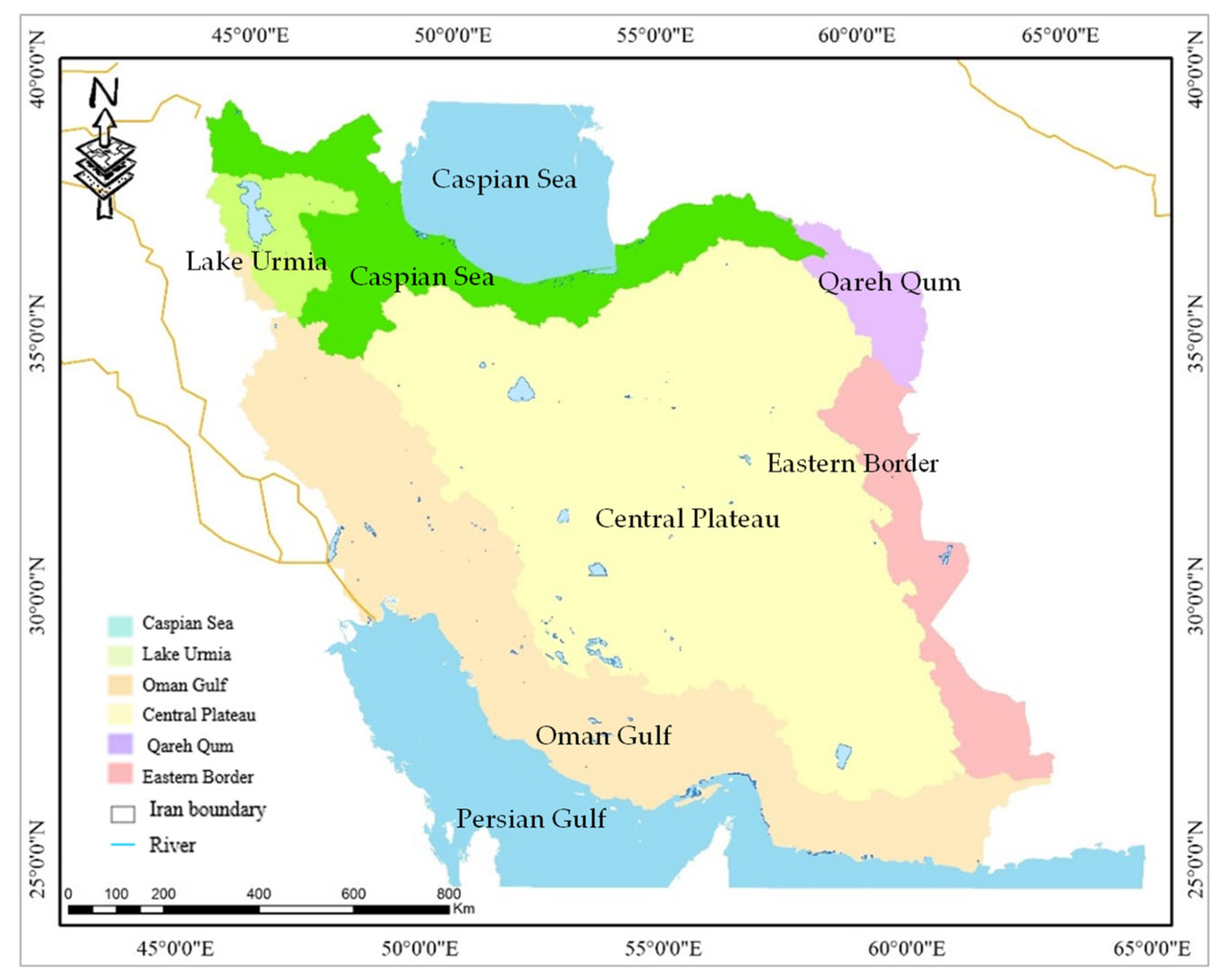
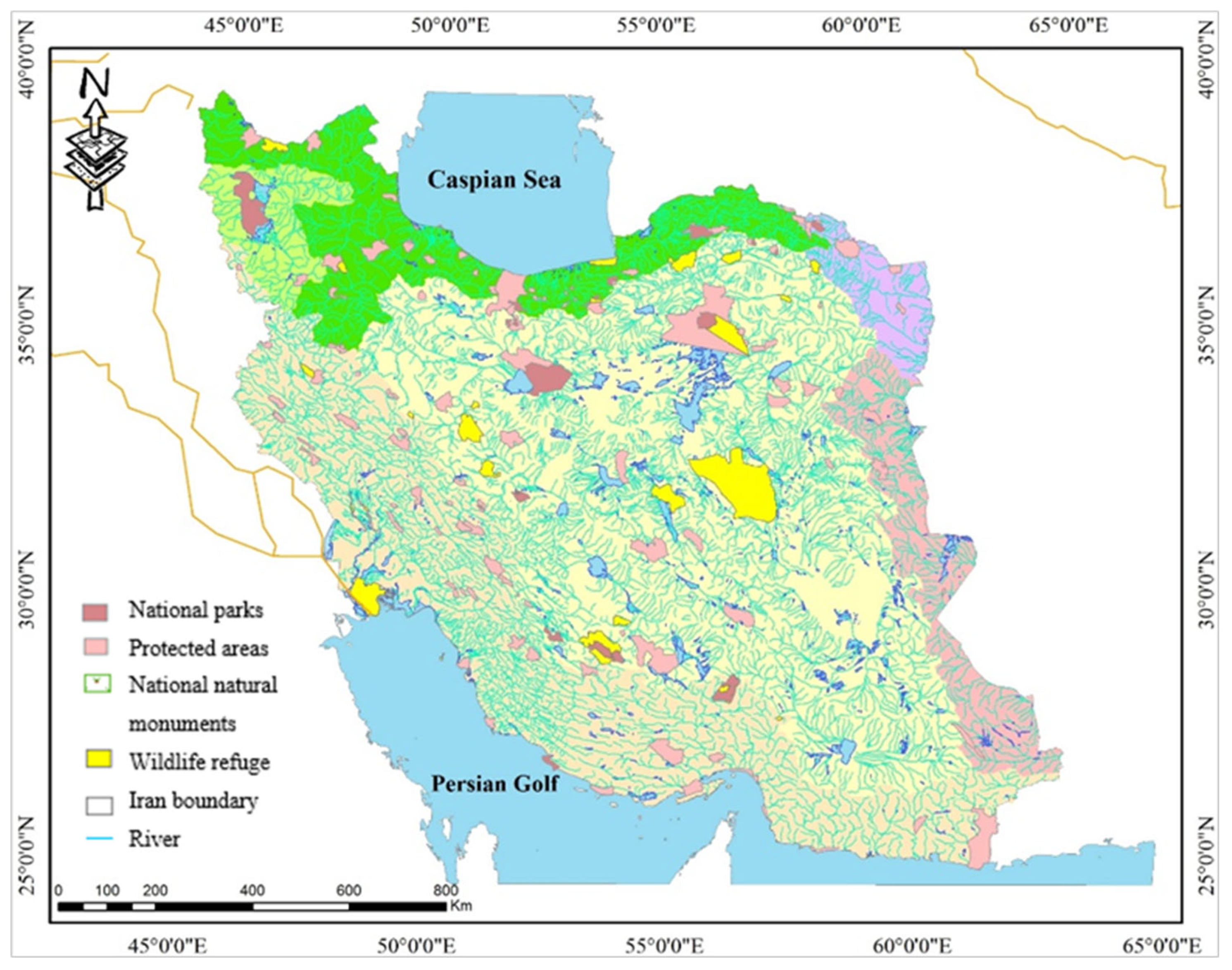
2.1. Study Area

Iran is a mountainous, arid, and ethnically diverse country in southwest Asia. Most of Iran consists of a central desert plateau surrounded by high mountains. This country receives an average rainfall of 250 mm per year, which is less than a third of the global average. It contains 0.36 of the world’s freshwater resources. However, the average evaporation rate is more than ten times the rainfall in this area [25]. The country encompasses five main catchments and 133 rivers. Iran is one of the countries with the largest variety of wetlands in the world: out of 42 wetlands known globally, 41 types (except for the very cold tundra wetlands) have been registered in this country. According to the World Convention for Protection of Wetlands [26], known wetlands include twelve types of coastal/marine wetlands, twenty types of inland wetlands, and ten types of artificial wetlands. Accordingly, Iran has 36 wetlands covering a total area of 1.413,040 ha that have been reported in the wetlands list of global importance by the Ramsar Convention [27]. Some of these water resources are located in the PAs network, which, according to the Department of Environment of Iran, includes 309 PAs (32 National Parks (hereafter NP), 183 Protected Areas with Sustainable Use of Natural Resource Areas (hereafter PASUNRA), 40 National Natural Monuments (hereafter NNM), and 54 Wildlife Refuges (hereafter WR) of about 110,000 ha [27]. A total of 31 catchment areas and six main basins can be found in Iran (Figure 1). The main basins are the Central Plateau (Markazi) located in the center of the country (824,400 km2), the Lake Urmia basin in the northwest (51,800 km2), the Persian Gulf and the Oman Gulf basin in the west and south (424,500 km2), the Eastern Border basin in the east (known previously as Hamoun) (103,200 km2), the Qareh Qum basin in the northeast (44,200 km2), and the Caspian Sea basin in the north (174,000 km2) [28].

2.2. Data Collection

This study focuses on wetlands and permanent rivers in the country. According to the wetlands reported in the Ramsar Convention, a list of important water resources of the country was identified and prepared (Appendix A). To study spatial and temporal changes in water resources in the studied area, the satellite imagery of Landsat-5 Thematic Mapper (TM) of May 1990, Landsat-7 Enhanced Thematic Mapper (ETM+) of May 2009, and Landsat-8 Operational Land Imager (OLI) of May 2021 were used with a spatial resolution of 30 m from the U.S. Geological Survey (USGS). Moreover, to assess the coverage of water bodies by PAs, the maps of these areas were classified and analyzed based on the classifications provided by the Department of Environment of Iran (including NPs, PASUNRAs, NNMs, and WRs). Hence, the percentage of water resources located in PAs was determined using overlay maps. Finally, water resources were prioritized based on a list of effective indicators and expert opinions (Table 1).

2.3. Methods

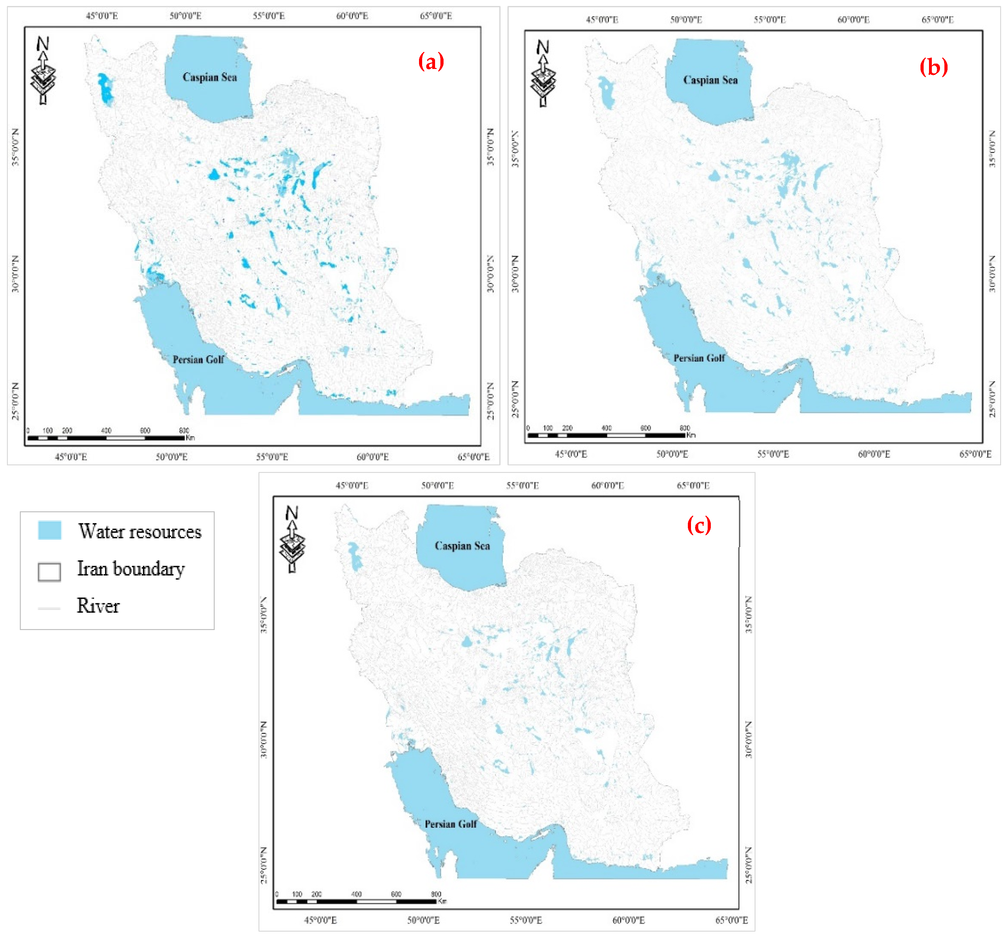
2.3.1. Images Classification

In the first step, Landsat 8 OLI/TIRS Level-2 images were corrected for radiometric and atmospheric effects. We performed an atmospheric correction in this study since various atmospheric evaluations are necessary to predict the reflectance of the ground on the images during the pre-processing stage. A dark object subtraction method was used as one of the approaches for atmospheric correction based on images. Then, the Random Forest (RF) algorithm was used to classify these images from 1990 to 2021. The method of RF is commonly used in the case of land use and land cover (LULC) classification. This algorithm is implemented as a supervised classification pattern to improve LULC change classifications, consisting of many classifications and regression trees [40]. In the present study, 600 trees were classified each year using the RF algorithm, 300 samples were considered for a water body, and 300 samples were evaluated for the classification of non-water bodies. Moreover, the normalized-difference water index (NDWI) was used to extract the water body class from images in the ENVI software (Version 5.3). This index uses near-infrared (NIR) bands and visible green (G) bands to extract water bodies and remove vegetation and soil. The NDWI value varies from −1 to 1. Additionally, the higher value of this index demonstrates the abundance of water bodies in the area. On the other hand, normalized-difference vegetation indexes (NDVIs) and enhanced vegetation indexes (EVIs) are used for water resource classification because of the vegetation distribution around water resources [41,42,43]. Accordingly, two criteria (NDWI > NDVI and EVI < 0.1) and (NDWI > EVI and EVI < 0.1) were combined to identify water resources. In addition, to select training samples for each class, 1000 samples were examined from the sampled collection (training phase = 600 samples; validation phase = 400 samples). The overall accuracy (OA) was also used to assess the accuracy of the classification.

2.3.2. Water Resources Prioritization

According to Table 1, experts rated the effective indicators for each water resource on a scale of 1 to 5 (very low, low, moderate, high, and very high, respectively). In this study, the panel of experts comprised 40 national people, consisting of scientists specializing in water resources, ecohydrology, and PA management. Experts had at least six years of experience working or researching with or for PAs. We used the snowball sampling technique to identify qualified experts nationwide. In the end, 40 experts were selected and approached by telephone or email to ask whether they would be willing to participate in the survey. Experts who accepted the invitation received a detailed description of the research objectives and were informed that they were free to withdraw at any time.

3. Results

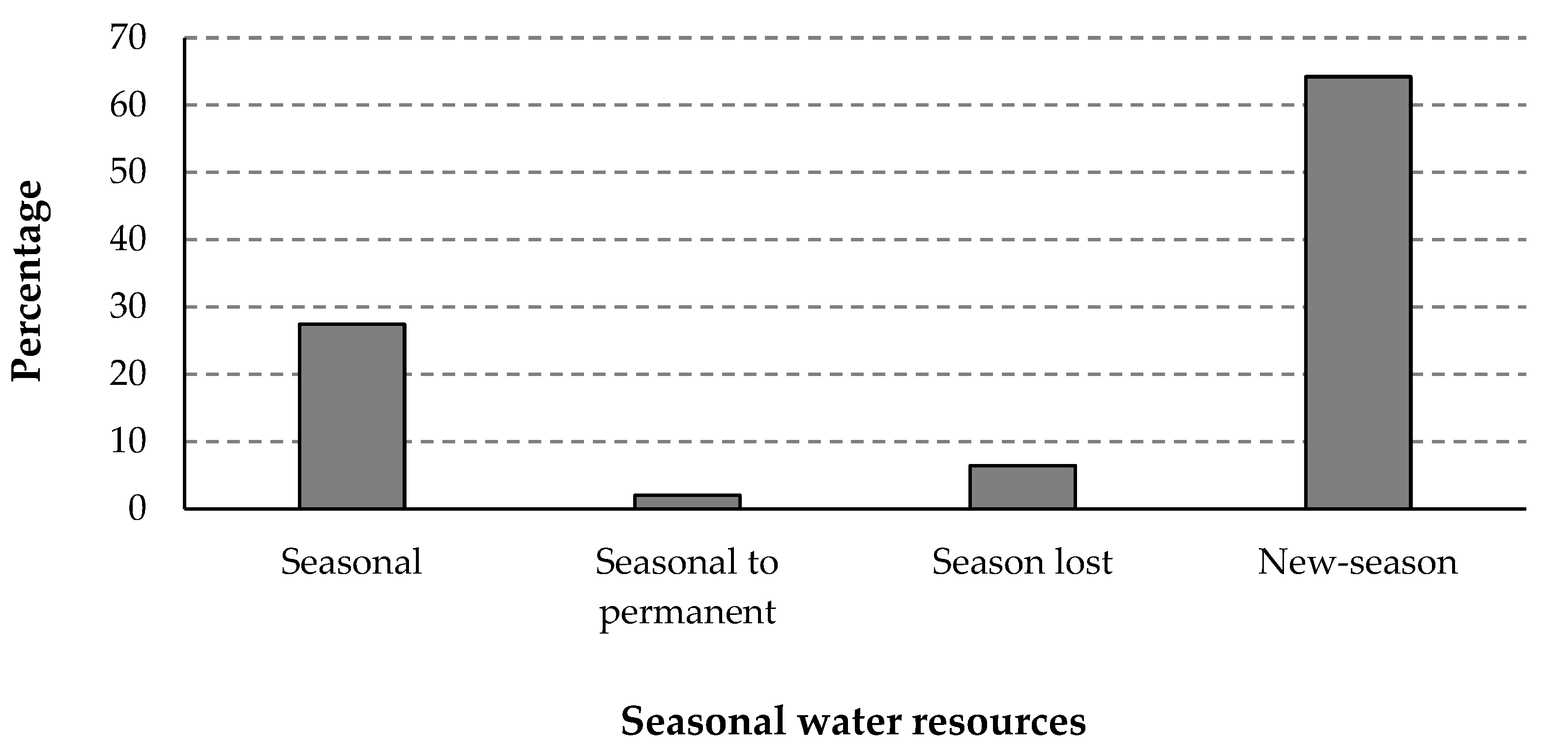
3.1. Assessment of Water Resources Status

The most important water resources of the country include wetlands, rivers, and lakes. Most of these resources are located in the north and northwest of Iran (including the Gilan and Mazandaran provinces). In contrast, the lowest number of water resources is located in the center and southeast of the country (such as Yazd, Sistan, and Kerman provinces). Moreover, this study monitored the status of water resources using Landsat imagery from 1990 to 2021 (Figure 2). These images were classified into two classes, namely that of water bodies and that of non-water bodies, using the RF classification system. Code zero (0) is related to the water body, and code one (1) is related to non-water bodies. In this study, the overall accuracy of the classification was 89%, 95%, and 98% for the classified images from the years 1990, 2009, and 2021, respectively. The results indicate that the overall accuracy reached a high efficiency and an acceptable level in terms of classification accuracy. According to Table 2, among the studied basins, the greatest water body in size covers 480 ha belonging to the Western basin (data from 2021), while the smallest area (i.e., 15 ha) belongs to the Eastern border basin (data from 2009). Water bodies with a large surface area are more likely to maintain a continuous surface throughout the year due to their higher water frequency. Nevertheless, water bodies with smaller areas tend to have a lower water frequency, which may be the result of evaporation, groundwater recharge, heavy irrigation, and reduced rainfall.
The results demonstrate that the air temperature has increased over the last few years, and over 1990–2021, Iran’s average air temperature increased by half a centigrade degree (Figure 3). According to Figure 4, the greatest rainfall percentage in the country was noted for the Gulf of Oman basin, with a value of 32.3%. In contrast, the lowest percentage was noted for the Eastern Border basin, with a value of 7.7%. Figure 5 shows the time series of seasonal water resource changes, which include seasonal, seasonal to permanent, seasonal lost, and new season. The results indicate that about 64.2% of the earth’s area comprises new seasonal water bodies (Figure 5). Consequently, seasonal water bodies have increased significantly in the country, and during the studied years, so have artificial dams and reservoirs. Most of the rainfall in the country has occurred in the form of floods. These sudden rains have less ability to feed and store water in aquifers (Figure 5).

3.2. Assessment of Water Resource Status

The present study prioritized water resources (Appendix A) based on expert opinion rating indicators from Table 1. The following wetlands were rated have the top five priorities for conservation: Anzali (4.36), Bakhtegan (4.28), Arjan (4.18), Miankaleh (4.00), and Choghakhor (3.96; Table 3). Consequently, the highest-priority rating was assigned to the Anzali Wetland with a value of 4.36, while the conservation of the Gomishan Wetland was thought to be the lowest priority (rated as 1.55) among the studied wetlands. Likewise, among other water resources, the highest priority was afforded to Lake Urmia, with a score of 3.88, and the lowest was Namak Lake, with a score of 1.33. In addition, high-sensitivity rivers such as the Karaj, Sardabroud, Sefidrud, Korr, and Ab Koohrang rivers were found to be mostly dispersed in the western areas, while other water resources are dispersed in the north, northwest, and west of the country.

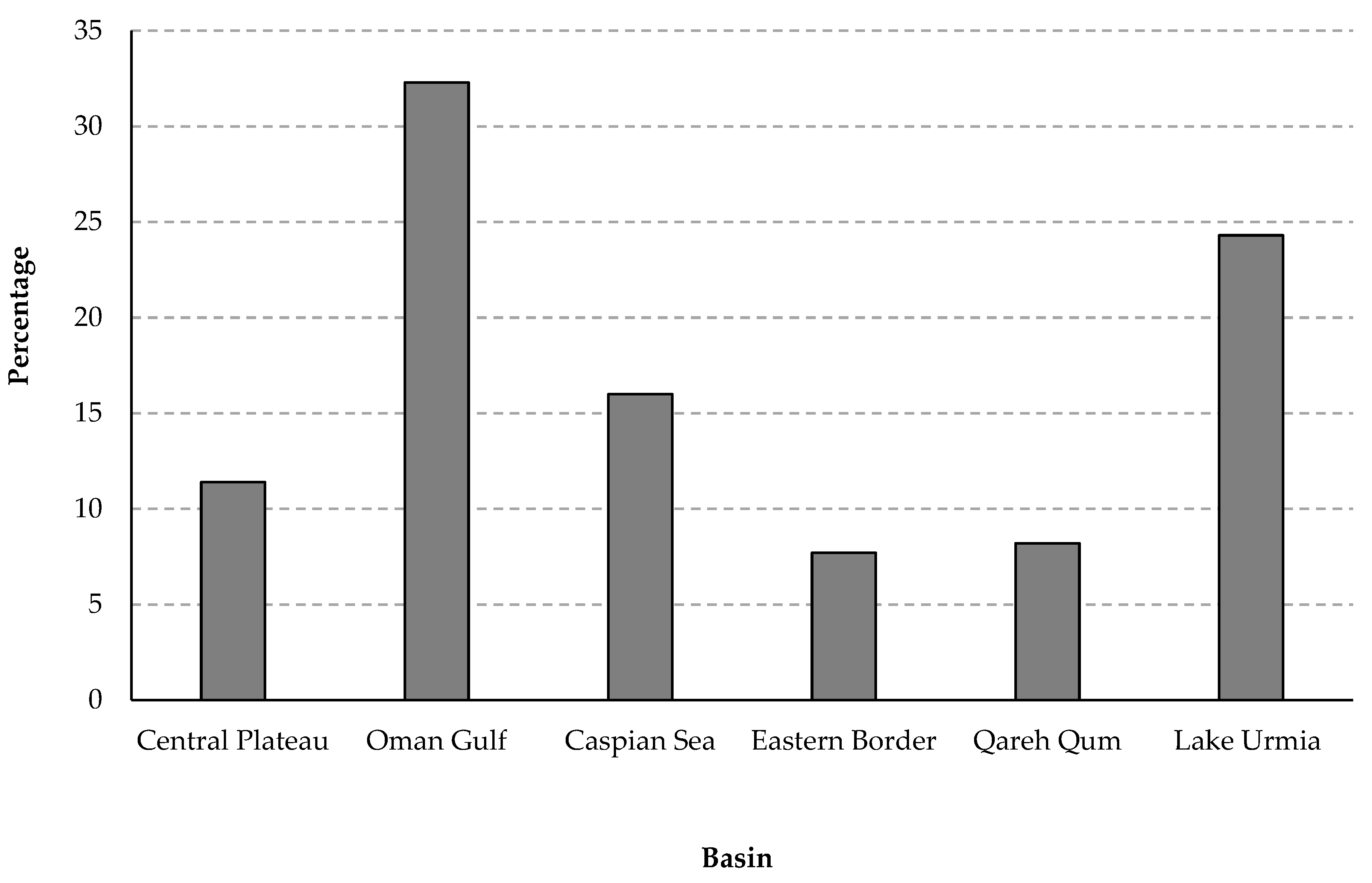
3.3. Water Resources Covered by PAs in Iran

The water resource levels covered by PAs in Iran were investigated (Figure 6). According to the results, 13.7% of the water resources are located in PAs, particularly surface water resources, which are more supported by PAs than any other water resource type. It should be noted that although some rivers’ branches are located in PAs, only seven rivers (i.e., Karaj, Chalous, Jajrud, Kashfarud, Tajan, Sard Abroad, and Haraz) are fully protected by PAs. These include the four international wetlands of Choghakhor, Anzali, Alagol-Ulmagol-Ajigol, and Dorage Sangi.

4. Discussion

Understanding changes in water resources and controlling for influential factors can help implement sustainable water resource management to sustain agricultural, industrial, and domestic activities [44,45]. The present study examined the status of water resources in Iran using Landsat imagery from 1990 to 2021. The conservation of these resources was prioritized based on expert ratings. Finally, this study investigated the extent to which water resources are located in PAs. The results revealed that most of the water resources in Iran are located in the north and northwest due to climatic conditions, topography, ambient temperature, and annual rainfall. Conversely, the lowest amount of water resources is located in the center and southeast of the country due to the high ambient temperature and evaporation and the lower rainfall levels. It should be highlighted that the central parts of the country, which are covered by deserts, are largely uninhabited [46]. A geographical imbalance also exists in water demand. Iran has an uneven population distribution, with most people living in the north and west [46].
The assessment of a time series of the country’s water resources from 1990 to 2021 indicates a decrease in groundwater aquifer levels due to population growth, urbanization, increasing industrialization, uncontrolled exploitation of these resources, and neglect of participatory management [47]. In line with this result, Ashraf et al. [48] reported that Iran’s groundwater had been depleted by around ~74 km3 during 2002–2015. Additionally, from three decades ago to the past decade (2011–2021), the average long-term rainfall has decreased from 254 mm to about 240 mm per year [47]. Moreover, in recent years, rainfall in the country has been in the form of floods [49], which are less likely to feed and store aquifers due to the sudden rainfall. The development of dams is another reason for the decrease in water resources in the country, which according to the report by the Statistical Centre of Iran [50], leads to an increase in water stress due to water retention. The consequence of reduced availability of water resources are droughts, loss of vegetation, increasing salinity of water resources, land subsidence, creation of pits in the plains, a water stress crisis, food insecurity, and increasing levels of dust. These findings have been confirmed by other studies [45,51], which have illustrated that surface water resources have decreased in recent years, leading to numerous detrimental effects.
In this study, the Anzali Wetland, as one of the international Ramsar Conventions (registered in June 1975), was considered a top conservation priority. The Anzali Wetlands are located in northern Iran and southwest of the Caspian Sea. As a coastal wetland, it provides important habitat for birds (the wintering habitat for a variety of waterbird species; [52]) and constitutes a source of fish production in the Caspian Sea. However, in recent decades, Anzali Wetland has been subjected to environmental issues such as urban sprawl and gradual land degradation [53], and biological organisms in the Anzali Wetland are also threatened by toxic substances [54]. Additionally, past research indicated that the agricultural sector could be considered the most important cause of Anzali Wetland degradation [55,56]. In contrast, Gomishan Wetland was found to be of the lowest priority for conservation due to its geographical location (located in Golestan province, northern Iran), less biological sensitivity (mean depth of wetland is 1.5 m [57]; moderate risk of heavy metal contamination [58]), and high conservation status (due to strict environmental regulations in this area [59]).
Among the lakes, as another type of surface water resource studied, the highest value for the conservation priority was ascribed to Lake Urmia (located in West Azerbaijan province, northwestern Iran) due to its conservation status, high biological sensitivity, and habitat threat to the area. Additionally, agriculture, farmer behavior, and excessive groundwater consumption must be considered [60]. Since 2005, this hypersaline lake in northwestern Iran began to dry up [61]. It should be noted that, in the Urmia lake basin, more than 36 cities and 3150 villages [62] have more than 6 million inhabitants existing [63]. In contrast, the lowest value was ascribed to Namak Lake because of the lower value for species life and overall lower conservation priority. Other literature supports these findings [52,64].
Finally, our analysis of the distribution of water resources across Pas demonstrated that Pas support more surface water resources than any other LULC type in Iran. Of the Anzali Wetland, 7238 ha are in the Pas network, including the Siahkeshim PA, Selke, Sorkhankol, and Chokam WRs. Thus, although PAs in Iran are critical and should be prioritized for conservation, water resources in these areas are currently not adequately protected. According to Azizi Jalilian et al. [17], for example, the conservation status of water resources in two management classes of PAs, namely PASUNRA and NNMs, is weak, and planning and decision-making are needed to address this issue.

5. Conclusions

Considering the many pressures on water resources, dedicated efforts are urgently needed to achieve effective conservation and sustainable management. The present study has examined water resources in the PAs of Iran and prioritized these valuable resources for conservation. According to the results, the mismatch between ecological significance and the protection of water resources in PAs needs to be addressed. These problems are exacerbated because of the current water crisis in Iran and the country’s water scarcity problem. To control water resources for various uses, the percentage of allocated water supplies should be kept to a minimum. Conserving water resources in PAs with different management goals can be a practical and useful measure. The present study offers planners guidance on prioritizing the conservation of varying water resources using effective criteria and indicators. Identifying water resources of great conservation value constitutes the first and critical step in planning the sustainable use of these resources, which, if appropriately implemented, will lead to the conservation of these resources.
In future research, water resources should be assessed according to social, economic, and environmental parameters. The conditions of the water crisis need to be analyzed further in light of management requirements. Simulations of changing water resources are needed to predict future levels and distributions to equip Iran against the detrimental effects of the water crisis.

Author Contributions

Conceptualization, H.E. and S.M.M.S.; methodology, P.S. and H.E.; software, P.S. and A.D.; formal analysis, P.S. and A.D.; writing—original draft preparation, P.S. and H.E.; writing—review and editing, S.M.M.S., I.D.W., and A.D.; visualization, P.S., S.M.M.S. and A.D.; supervision, H.E. All authors have read and agreed to the published version of the manuscript.

Funding

This research received no external funding.

Data Availability Statement

The data supporting the findings of this study are available from the first (P.S.) and second (H.E.) authors upon reasonable request.

Conflicts of Interest

The authors declare no conflict of interest.

Appendix A

Table A1. List of the most important water resources in the studied area.
ProvinceWater Resources (Area in ha)ProvinceWater Resources (Area in ha)ProvinceWater Resources (Area in ha)
AlborzSalehieh Wetland (150)GilanAnzali Wetland (19,000)Kohgiluyeh and Boyer AhmadMor Zard Zeilaei Wetland (35)
BushehrMand Wetland (2000)Bojagh Wetland (160)Brom Alwan Wetland (15)
Hele Wetland (2000)Mountain Gol Lake (1)
Amirkalayeh Wetland (458)KordestanZarivar Wetland (2403)
Nayband Wetland (4000)GolestanIncheh Wetland (1250)LorestanGahar Lake (85)
Nayband Marine National Park (19,500)Alagol-Ulmagol-Ajigol Wetlands Complex (3027)Bishe Dalan Wetland (913)
Deir- Nakhilo Marine National Park (20,000)Gomishan Wetland (17,700)MarkaziMeighan Wetland (25,000)
Chaharmahal and BakhtiariGandoman Wetland (700)HamedanPirsalman Wetland (3)
MazandaranMiankaleh Wetland (40,000)
Solagan Wetland (3000)Aqgol Wetland (3000)Fereydunkenar Wteland (4500)
Aliabad Wetland (140)Cham Shor Wetland (500)Shurmast Lake (1.5)
Choghakhor Wetland (2300)HormozganShahreno Estuary and Khore Khalasi *North KhorasanAq Gheshlagh Wetland (800)
East AzerbaijanQareh Gheshlagh Wetland (57,000)Central Jask Estuary *
Ghorigol Wetland (120)Delta of Shor, Shirin and Minab Rivers (31,606)QomNamak Lake (180,000)
EsfahanGavkhoni Wetland (47,000)Hara East Gabrik (5519)Hoze Soltan Wetland (37,075)
Golpayegan Shor Wetland (7628)Khorkhoran Wetland (102,000)Sistan and BaluchestanHamoun Wetland (60,000)
FarsMaharloo Lake (60,000)Shidvar Wetland (98)Khorbahoo Wetland and Gowatr Bay (29,500)
Barm Firooz Lake (283,200)KermanJazmourian Wetland (330,000)Hamoun Helmand Wetland (150,000)
Barmeshor Lake (30)KermanshahHashilan Wetland (450)Hamoun Pozak Wetland (160,000)
Kamjan Wetland (10,000)Niloofar Lake (1331)
Kaftar Wetland (4800)Khorasan RazaviBazangan Lake (80)South KhorasanKaji Namkzar Wetland (22,000)
Haft Barm Wetland (20,000)KhuzestanGaz and Hara Wetland (27,830)West AzerbaijanPir Ahmad Kandi Wetland (100)
Garde Gheit and Meymand Wetland (800)
Bakhtegan Wetland (350,000)Khor Musa and Khor Al-Umayya Wetland*Shorgol, Yadegarloo and Dargeh Sangi Wetlands Complex (2494)
Haram and Karion Wetland (10,000)Shadegan Wetland (328,500)Soldoz Wetland (375)
Parishan Wetland (4300)Bamdej Wetland (4000)Aq Ziarat Wetland (10)
GhazvinOvan Lake (7)Shimbar Wetland (15,000)Kani Barazan Wetland (907)
GilanAstara Steel Wetland (56)Hur al-Azim Wetland (120,000)Urmia Lake (521,000)
Jokandan Talesh Wetland (238)Miangaran Wetland (2500)Qopi Baba Ali Lake (500)
Note: * No reliable information was found.

References

  1. Bonet-García, F.J.; Pérez-Luque, A.J.; Moreno-Llorca, R.A.; Pérez-Pérez, R.; Puerta-Piñero, C.; Zamora, R. Protected areas as elicitors of human well-being in a developed region: A new synthetic (socioeconomic) approach. Biol. Conserv. 2015, 187, 221–229. [Google Scholar] [CrossRef]
  2. Azaryan, M.; Vajari, K.A.; Amanzadeh, B. Herb-layer diversity and morphological traits of beech trees (Fagus orientalis L.) in development stages of natural temperate forests. Biologia 2022, 78, 1–8. [Google Scholar] [CrossRef]
  3. Nabout, J.C.; Tessarolo, G.; Pinheiro, G.H.B.; Marquez, L.A.M.; de Carvalho, R.A. Unraveling the paths of water as aquatic cultural services for the ecotourism in Brazilian Protected Areas. Glob. Ecol. Conserv. 2022, 33, 01958. [Google Scholar] [CrossRef]
  4. Li, M.; Liang, D.; Xia, J.; Song, J.; Cheng, D.; Wu, J.; Li, Q. Evaluation of water conservation function of Danjiang River Basin in Qinling Mountains, China based on InVEST model. J. Environ. Manag. 2021, 286, 112212. [Google Scholar] [CrossRef]
  5. López-Morales, C.A.; Mesa-Jurado, M.A. Valuation of hidden water ecosystem services: The replacement cost of the aquifer system in Central Mexico. Water 2017, 9, 571. [Google Scholar] [CrossRef] [Green Version]
  6. Karimi, Z.; Abdi, E.; Deljouei, A.; Cislaghi, A.; Shirvany, A.; Schwarz, M.; Hales, T.C. Vegetation-induced soil stabilization in coastal area: An example from a natural mangrove forest. Catena 2022, 216, 106410. [Google Scholar] [CrossRef]
  7. Valera, C.A.; Pissarra, T.C.T.; Filho, M.V.M.; Valle Júnior, R.F.D.; Oliveira, C.F.; Moura, J.P.; Sanches Fernandes, L.F.; Pacheco, F.A.L. The buffer capacity of riparian vegetation to control water quality in anthropogenic catchments from a legally protected area: A critical view over the Brazilian new forest code. Water 2019, 11, 549. [Google Scholar] [CrossRef] [Green Version]
  8. Wang, W.; Chen, Y.; Wang, W.; Yang, Y.; Hou, Y.; Zhang, S.; Zhu, Z. Assessing the influences of land use change on groundwater hydrochemistry in an oasis-desert region of Central Asia. Water 2022, 14, 651. [Google Scholar] [CrossRef]
  9. Torremorell, A.; Hegoburu, C.; Brandimarte, A.L.; Rodrigues, E.H.C.; Pompêo, M.; da Silva, S.C.; Moschini-Carlos, V.; Caputo, L.; Fierro, P.; Mojica, J.I. Current and future threats for ecological quality management of South American freshwater ecosystems. Inland Waters 2021, 11, 125–140. [Google Scholar] [CrossRef]
  10. Ao, S.; Ye, L.; Liu, X.; Cai, Q.; He, F. Elevational patterns of trait composition and functional diversity of stream macroinvertebrates in the Hengduan Mountains region, Southwest China. Ecol. Indic. 2022, 144, 109558. [Google Scholar] [CrossRef]
  11. Binet, S.; Gogo, S.; Laggoun-Défarge, F. A water-table dependent reservoir model to investigate the effect of drought and vascular plant invasion on peatland hydrology. J. Hydrol. 2013, 499, 132–139. [Google Scholar] [CrossRef] [Green Version]
  12. Masud, M.M.; Othman, A.; Akhtar, R.; Rana, M.S. The underlying drivers of sustainable management of natural resources: The case of marine protected areas (MPAs). Ocean Coast. Manag. 2021, 199, 105405. [Google Scholar] [CrossRef]
  13. Gopal, B. A conceptual framework for environmental flows assessment based on ecosystem services and their economic valuation. Ecosyst. Serv. 2016, 21, 53–58. [Google Scholar] [CrossRef]
  14. Gunderson, L.H.; Cosens, B.; Garmestani, A.S. Adaptive governance of riverine and wetland ecosystem goods and services. J. Environ. Manag. 2016, 183, 353–360. [Google Scholar] [CrossRef] [Green Version]
  15. Gurney, G.G.; Cinner, J.; Ban, N.C.; Pressey, R.L.; Pollnac, R.; Campbell, S.J.; Tasidjawa, S.; Setiawan, F. Poverty and protected areas: An evaluation of a marine integrated conservation and development project in Indonesia. Glob. Environ. Chang. 2014, 26, 98–107. [Google Scholar] [CrossRef]
  16. Rinawati, F.; Stein, K.; Lindner, A. Climate change impacts on biodiversity—The setting of a lingering global crisis. Diversity 2013, 5, 114–123. [Google Scholar] [CrossRef] [Green Version]
  17. Azizi Jalilian, M.; Salmanmahiny, A.; Shayesteh, K.; Taheri Sarteshnizi, F. Conservation prioritization of the Iran’s Surface Water resources based on ecological sensitivity. J. Water Sustain. Develop. 2021, 8, 33–46. [Google Scholar]
  18. Bakhtar, A.; Rahmati, A.; Shayeghi, A.; Teymoori, J.; Ghajarnia, N.; Saemian, P. Spatio-temporal evaluation of GPM-IMERGV6.0 final run precipitation product in capturing extreme precipitation events across Iran. Water 2022, 14, 1650. [Google Scholar] [CrossRef]
  19. Ward, F.A.; Salman, D.; Amer, S.A. Managing food-ecosystem synergies to sustain water resource systems. Sci. Tot. Environ. 2021, 796, 148945. [Google Scholar] [CrossRef]
  20. Irannezhad, M.; Ahmadi, B.; Liu, J.; Chen, D.; Matthews, J.H. Global water security: A shining star in the dark sky of achieving the sustainable development goals. Sustain. Horiz. 2022, 1, 100005. [Google Scholar] [CrossRef]
  21. Walker, D.W.; Smigaj, M.; Tani, M. The benefits and negative impacts of citizen science applications to water as experienced by participants and communities. Wiley Interdiscip. Rev. Water 2021, 8, e1488. [Google Scholar] [CrossRef]
  22. Failler, P.; Touron-Gardic, G.; Drakeford, B.; Sadio, O.; Traore, M.-S. Perception of threats and related management measures: The case of 32 marine protected areas in West Africa. Mar. Policy 2020, 117, 103936. [Google Scholar] [CrossRef]
  23. Caro-Borrero, A.; Carmona-Jiménez, J.; Figueroa, F. Water resources conservation and rural livelihoods in protected areas of central Mexico. J. Rural Stud. 2020, 78, 12–24. [Google Scholar] [CrossRef]
  24. Tyllianakis, E. “Please let me visit”: Management options for marine ecosystems in a Mediterranean Marine Protected Area. J. Nat. Conserv. 2022, 67, 126174. [Google Scholar] [CrossRef]
  25. Afshar, N.R.; Fahmi, H. Impact of climate change on water resources in Iran. Int. J. Energy Wat. Resour. 2019, 3, 55–60. [Google Scholar] [CrossRef]
  26. Ramsar Convention Secretariat. An Introduction to the Ramsar Convention on Wetlands; Ramsar Convention Secretariat: Gland, Switzerland, 2016. [Google Scholar]
  27. Department of Environment of Iran. Reports of Iran’s PAs; Department of Environment of Iran: Tehran, Iran, 2021.
  28. Fahmi, H. An Overview of Water Resources Management in the IR of Iran; Ministry of Energy of Iran: Tehran, Iran, 2012.
  29. Eini, M.R.; Olyaei, M.A.; Kamyab, T.; Teymoori, J.; Brocca, L.; Piniewski, M. Evaluating three non-gauge-corrected satellite precipitation estimates by a regional gauge interpolated dataset over Iran. J. Hydrol. Reg. Stud. 2021, 38, 100942. [Google Scholar] [CrossRef]
  30. Lor, S.; Malecki, R.A. Breeding ecology and nesting habitat associations of five marsh bird species in western New York. Waterbirds 2006, 29, 427–436. [Google Scholar] [CrossRef]
  31. Harms, T.M.; Dinsmore, S.J. Habitat associations of secretive marsh birds in Iowa. Wetlands 2013, 33, 561–571. [Google Scholar] [CrossRef] [Green Version]
  32. Jahani Shakib, F.; Malekmohamadi, B.; Yusefi, E.; Alipour, M. Developing management strategies using a new method for vulnerability assessment of wetland ecosystems (Case study: Choghakhor wetland). J. Environ. Sci. Tech. 2017, 19, 377–391. [Google Scholar]
  33. Giese, E.E.G.; Howe, R.W.; Wolf, A.T.; Niemi, G.J. Breeding birds and anurans of dynamic coastal wetlands in Green Bay, Lake Michigan. J. Great Lakes Res. 2018, 44, 950–959. [Google Scholar] [CrossRef]
  34. Saunders, S.P.; Hall, K.A.; Hill, N.; Michel, N.L. Multiscale effects of wetland availability and matrix composition on wetland breeding birds in Minnesota, USA. Condor 2019, 121, 24–30. [Google Scholar] [CrossRef]
  35. Wiest, W.A.; Correll, M.D.; Marcot, B.G.; Olsen, B.J.; Elphick, C.S.; Hodgman, T.P.; Guntenspergen, G.R.; Shriver, W.G. Estimates of tidal-marsh bird densities using Bayesian networks. J. Wildl. Manag. 2019, 83, 109–120. [Google Scholar] [CrossRef]
  36. Castello, L. Science for conserving Amazon freshwater ecosystems. Aquat. Conserv. Mar. Freshw. Ecosyst. 2021, 31, 999–1004. [Google Scholar] [CrossRef]
  37. Sarkheil, H.; Rahbari, S.; Azimi, Y. Fuzzy-Mamdani environmental quality assessment of gas refinery chemical wastewater in the Pars special economic and energy zone. Environ. Chall. 2021, 3, 100065. [Google Scholar] [CrossRef]
  38. Magdalena, U.R.; Francisco, C.N.; Lopes, L.G.; Rodriguez, D.A. Conservation policy changes in protected areas on hilltops in Brazil: Effects on hydrological response in a small watershed. Water Resour. Manag. 2022, 36, 1251–1270. [Google Scholar] [CrossRef]
  39. Zhang, P.; Wang, J.; Jin, R.; Yan, H.; LI, C.; Zhu, W. Changes of water yield in Tumen River Basin, China: Trade-offs between precipitation and actual evapotranspiration. Arab. J. Geosci. 2022, 15, 1–14. [Google Scholar] [CrossRef]
  40. Iban, M.C.; Sahin, E. Monitoring land use and land cover change near a nuclear power plant construction site: Akkuyu case, Turkey. Environ. Monitor. Assess. 2022, 194, 1–19. [Google Scholar] [CrossRef]
  41. Chen, B.; Cui, P.; Xu, H.; Lu, X.; Lei, J.; Wu, Y.; Shao, M.; Ding, H.; Wu, J.; Cao, M. Assessing the suitability of habitat for wintering Siberian cranes (Leucogeranus leucogeranus) at different water levels in Poyang lake area, China. Polish J. Ecol. 2016, 64, 84–97. [Google Scholar] [CrossRef]
  42. Wang, X.; Wu, C.; Peng, D.; Gonsamo, A.; Liu, Z. Snow cover phenology affects alpine vegetation growth dynamics on the Tibetan Plateau: Satellite observed evidence, impacts of different biomes, and climate drivers. Agricul. For. Meteorol. 2018, 256, 61–74. [Google Scholar] [CrossRef]
  43. Zou, Z.; Dong, J.; Menarguez, M.A.; Xiao, X.; Qin, Y.; Doughty, R.B.; Hooker, K.V.; Hambright, K.D. Continued decrease of open surface water body area in Oklahoma during 1984–2015. Sci. Tot. Environ. 2017, 595, 451–460. [Google Scholar] [CrossRef]
  44. Kafy, A.-A.; Al Rakib, A.; Akter, K.S.; Rahaman, Z.A.; Mallik, S.; Nasher, N.R.; Hossain, M.I.; Ali, M.Y. Monitoring the effects of vegetation cover losses on land surface temperature dynamics using geospatial approach in Rajshahi city, Bangladesh. Environ. Chall. 2021, 4, 100187. [Google Scholar] [CrossRef]
  45. Xia, H.; Zhao, J.; Qin, Y.; Yang, J.; Cui, Y.; Song, H.; Ma, L.; Jin, N.; Meng, Q. Changes in water surface area during 1989–2017 in the Huai River Basin using Landsat data and Google earth engine. Remote Sens. 2019, 11, 1824. [Google Scholar] [CrossRef]
  46. Yazdandoost, F. Dams, drought and water shortage in today’s Iran. Iran. Stud. 2016, 49, 1017–1028. [Google Scholar] [CrossRef]
  47. Zeydalinejad, N.; Nassery, H.R. A review on the climate-induced depletion of Iran’s aquifers. Stoch. Environ. Res. Risk Assess. 2022, 13, 1–24. [Google Scholar] [CrossRef]
  48. Ashraf, S.; Nazemi, A.; AghaKouchak, A. Anthropogenic drought dominates groundwater depletion in Iran. Sci. Rep. 2021, 11, 1–10. [Google Scholar] [CrossRef]
  49. Razavi, S.; Gober, P.; Maier, H.R.; Brouwer, R.; Wheater, H. Anthropocene flooding: Challenges for science and society. Hydrol. Process. 2020, 34, 1996–2000. [Google Scholar] [CrossRef] [Green Version]
  50. The Statistical Centre of Iran. Reports of Water Resources State; Ministry of Water: Tehran, Iran, 2021. [Google Scholar]
  51. Kseňak, Ľ.; Pukanská, K.; Bartoš, K.; Blišťan, P. Assessment of the Usability of SAR and Optical Satellite Data for Monitoring Spatio-Temporal Changes in Surface Water: Bodrog River Case Study. Water 2022, 14, 299. [Google Scholar] [CrossRef]
  52. Sarkheil, H.; Rezaei, H.R.; Rayegani, B.; Khorramdin, S.; Rahbari, S. Fuzzy dynamic system analysis of pollution accumulation in the Anzali wetland using empirical-nonlinear aspects of an economically-socio-environmental interest conflict. Environ. Chall. 2021, 2, 100025. [Google Scholar] [CrossRef]
  53. Jafari, M.; Majedi, H.; Monavari, S.M.; Alesheikh, A.A.; Kheirkhah Zarkesh, M. Dynamic simulation of urban expansion based on cellular automata and logistic regression model: Case study of the Hyrcanian Region of Iran. Sustainability 2016, 8, 810. [Google Scholar] [CrossRef] [Green Version]
  54. Esmaeilzadeh, M.; Mahmoudpuor, E.; Haghighat, S.; Esmaeilzadeh, S.; Aliani, H.; Yazdanfar, N. Contamination and ecological risk assessment of trace elements in sediments of the Anzali Wetland, Northern Iran. Water Sci. Tech. 2021, 84, 2578–2590. [Google Scholar] [CrossRef]
  55. Ebrahimi, E.; Asadi, H.; Joudi, M.; Rashti, M.R.; Farhangi, M.B.; Ashrafzadeh, A.; Khodadadi, M. Variation entry of sediment, organic matter and different forms of phosphorus and nitrogen in flood and normal events in the Anzali wetland. J. Water Clim. Chang. 2022, 13, 434–450. [Google Scholar] [CrossRef]
  56. Fallah, M.; Zamani-Ahmadmahmoodi, R. Assessment of water quality in Iran’s Anzali Wetland, using qualitative indices from 1985, 2007, and 2014. Wetl. Ecol. Manag. 2017, 25, 597–605. [Google Scholar] [CrossRef]
  57. Qureshi, S.; Alavipanah, S.K.; Konyushkova, M.; Mijani, N.; Fathololomi, S.; Firozjaei, M.K.; Homaee, M.; Hamzeh, S.; Kakroodi, A.A. A remotely sensed assessment of surface ecological change over the Gomishan Wetland, Iran. Remote Sens. 2020, 12, 2989. [Google Scholar] [CrossRef]
  58. Kalani, N.; Riazi, B.; Karbassi, A.; Moattar, F. Measurement and ecological risk assessment of heavy metals accumulated in sediment and water collected from Gomishan international wetland, Iran. Water Sci. Tech. 2021, 84, 1498–1508. [Google Scholar] [CrossRef]
  59. Shirood Mirzaie, F.; Ghorbani, R.; Parafkandeh, F.; Nasrollahzadeh Saravi, H. Environmental Impact Assessment of Aquaculture Effluent on Benthic Fauna; Case Study: Gomishan Wetland, Golestan Province. J. Anim. Environ. 2018, 10, 499–510. [Google Scholar]
  60. Es’haghi, S.R.; Karimi, H.; Rezaei, A.; Ataei, P. Content Analysis of the Problems and Challenges of Agricultural Water Use: A Case Study of Lake Urmia Basin at Miandoab, Iran. SAGE Open 2022, 12, 21582440221091247. [Google Scholar] [CrossRef]
  61. Alvyar, Z.; Shahbazi, F.; Oustan, S.; Dengiz, O.; Minasny, B. Digital mapping of potentially toxic elements enrichment in soils of Urmia Lake due to water level decline. Sci. Tot. Environ. 2022, 808, 152086. [Google Scholar] [CrossRef]
  62. Hamidi, S.M.; Fürst, C.; Nazmfar, H.; Rezayan, A.; Yazdani, M.H. A Future Study of an Environment Driving Force (EDR): The Impacts of Urmia Lake Water-Level Fluctuations on Human Settlements. Sustainability 2021, 13, 11495. [Google Scholar] [CrossRef]
  63. Moadel, M.; Amidpour, M.; Abedi, Z.; Kani, A. Prospect of water energy environment nexus under energy and climate change scenarios (case study: Urmia Lake Basin). Int. J. Environ. Sci. Technol. 2022, 19, 10649–10662. [Google Scholar] [CrossRef]
  64. Ebrahimi, E.; Filizadeh, Y.; Asgari, K. Anzali wetland hydrology monitoring to detect the effects of land use and climate change. In Proceedings of the 2009 Second International Conference on Environmental and Computer Science, Dubai, United Arab Emirates, 28–30 December 2009; pp. 122–127. [Google Scholar]
Figure 1. Location main basins in the studied area.
Water 14 04121 g001
Figure 2. Changes in water resources in Iran: (a) 1990, (b) 2009, and (c) 2021.
Water 14 04121 g002
Figure 3. Average air temperature in Iran (1990–2021).
Water 14 04121 g003
Figure 4. Percentage of rainfall in Iran by basin (1990–2021).
Water 14 04121 g004
Figure 5. Percentage of seasonal water resources in Iran (1990–2021).
Water 14 04121 g005
Figure 6. Water bodies located in the Protected Areas (PAs) of Iran.
Water 14 04121 g006
Table 1. Effective criteria and indicators to prioritize water resources.
CriteriaIndicatorsReference
BiodiversityAnimal species:
Birds
Mammals
Fish
Reptiles
Amphibian
[26,29,30,31,32,33,34,35,36,37,38,39]
Plant species:
Medicinal consumption
Soil protection
Livestock grazing
Birds feeding
Industrial and commercial consumption
Natural or man-made originNatural source
Man-made source
ExtensivenessArea
Flow regimePermanent
Seasonal
Managerial classification (according to conservation goals)NPs
PASUNRAs
NNMs
WRs
No-hunting areas
Protective importanceDegree of animal species protection
(CR-EN-VU-cd-nt-Ic)
Birds list (IBA and EBA)
Water resource stateWater quality
Aquatic resource state
Surface water supply
Groundwater supply
Reclamation and reconstructionSuitability for preservation
Sustainable reconstruction process
Flood mitigation actions
Habitat qualityProminent and unique
Suitable to sustain life
Meeting human needs
Accessibility level
Population abundance
Cultural and social valuesCultural and historical importance
Economic valueImportance for the national economy
Employment
Economic benefits
Ecological potentialEcotourism activity development
Education
Research and interpretation
Table 2. Changes in water resources in the studied basins in Iran from 1990 to 2021.
Basin/Year199020092021
Area (ha)
Central Plateau80130180
Oman Gulf2478140
Lake Urmia 110220480
Eastern Border156895
Qareh Qum184548
Caspian Sea110240270
Table 3. Prioritization of the main water resources in Iran based on 5-point expert ratings (1 = very low to 5 = very high) of indicators (see Table 1).
Water ResourcesValueWater ResourcesValueWater ResourcesValue
Anzali Wetland4.36Hamoun Wetland3.11Hara East Gabrik2.52
Bakhtegan Wetland4.28Hashilan Wetland3.05Aq Ziarat Wetland2.48
Arjan Wetland4.18Bazangan Lake3.02Gandoman Wetland2.46
Miankaleh Wetland4.00Ovan Lake3.00Bojagh Wetland2.45
Choghakhor Wetland3.96Kaftar Wetland2.96Shorgol, Yadegarloo and Dargeh Sangi Wetland2.44
Deir- Nakhilo Marine National Park3.95Barm Firooz Lake2.94Cham Shor Wetland2.38
Aq Gheshlagh Wetland3.88Khorbahoo Wetland and Gowatr Bay2.90Incheh Wetland2.38
Urmia Lake3.88Shimbar Wetland2.85Pirsalman Wetland2.36
Hamoun Helmand Wetland3.82Zarivar Wetland2.84Hamoun Pozak Wetland2.36
Shadegan Wetland3.76Golpayegan Shor Wetland2.82Shidvar Wetland2.33
Nayband Marine National Park3.70Meighan Wetland2.81Fereydunkenar Wteland2.28
Alagol-Ulmagol-Ajigol Wetland Complex3.64Mor Zard Zeilaei Wetland2.78Jokandan Talesh Wetland2.26
Khorkhoran Wetland3.48Central Jask Estuary2.77Bamdej Wetland2.23
Nayband Wetland3.44Kaji Namakzar Wetland2.77Soldoz Wetland2.23
Mand Wetland3.43Salehieh Wetland2.76Astara Steel Wetland2.18
Amirkalayeh Wetland3.38Sulagan Wetland2.74Shurmast Lake2.14
Hoze Soltan Wetland3.34Ghorigol Wetland2.76Aliabad Wetland2.00
Gaz and Hara Wetland3.32Bishe Dalan Wetland2.73Niloofar Mirage Lake1.92
Miangaran Wetland3.26Hele Wetland2.68Delta of Shor, Shirin and Minab Rivers1.85
Haft Barm Wetland3.24Haram and Karion Wetland2.66Qareh Gheshlagh Wetland1.76
Aqgol wetland3.23Kamjan Wetland2.64Barmeshor Lake1.76
Gavkhoni Wetland3.22Jazmourian Wetland2.64Qopi Baba Ali Lake1.73
Hur al-Azim Wetland3.20Shahreno Estuary and Khore Khalasi2.63Garde Gheit and Meymand Wetland1.68
Pir Ahmad Kandi Wetland3.20Gahar Lake2.63Mountain Gol Lake1.55
Parishan Wetland3.14Kani Barazan Wetland2.54Gomishan Wetland1.55
Khor Musa and Khor Al-Umayya Wetland3.13Maharloo Lake2.54Namak Lake1.33
Publisher’s Note: MDPI stays neutral with regard to jurisdictional claims in published maps and institutional affiliations.

