
Real-Time Urban Flood Forecasting Systems for Southeast Asia—A Review of Present Modelling and Its Future Prospects

Department of Civil Engineering, Shibaura Institute of Technology, 3-7-5 Toyosu, Koto-ku, Tokyo 135-8548, Japan
*
Author to whom correspondence should be addressed.
Water 2023, 15(1), 178; https://doi.org/10.3390/w15010178
Submission received: 12 November 2022
/
Revised: 22 December 2022
/
Accepted: 29 December 2022
/
Published: 1 January 2023
(This article belongs to the Special Issue Urban Water-Related Problems)
Abstract
:Many urban areas in tropical Southeast Asia, e.g., Bangkok in Thailand, have recently been experiencing unprecedentedly intense flash floods due to climate change. The rapid flood inundation has caused extremely severe damage to urban residents and social infrastructures. In addition, urban Southeast Asia usually has inadequate capacities in drainage systems, complicated land use patterns, and a large vulnerable population in limited urban areas. To reduce the urban flood risk and enhance the resilience of vulnerable urban communities, it has been of essential importance to develop real-time urban flood forecasting systems for flood disaster prevention authorities and the urban public. This paper reviewed the state-of-the-art models of real-time forecasting systems for urban flash floods. The real-time system basically consists of the following subsystems, i.e., rainfall forecasting, drainage system modelling, and inundation area mapping. This paper summarized the recent radar data utilization methods for rainfall forecasting, physical-process-based hydraulic models for flood inundation prediction, and data-driven artificial intelligence (AI) models for the real-time forecasting system. This paper also dealt with available technologies for modelling, e.g., digital surface models (DSMs) for the finer urban terrain of drainage systems. The review indicated that an obstacle to using process-based hydraulic models was the limited computational resources and shorter lead time for real-time forecasting in many urban areas in tropical Southeast Asia. The review further discussed the prospects of data-driven AI models for real-time forecasting systems.
1. Introduction
Urban areas in Southeast Asia have been expanding and changing more rapidly than constructing and maintaining their storm drainage systems. If adequate flood risk management is not carried out, threats from climate change, growing urbanization, and deteriorated drainage infrastructure could increase flood disasters. Urban flood management has significantly benefited from the hydroinformatics tools such as rainfall predictions and flood modelling. However, data availability is one of the primary limitations of using hydroinformatics tools. In addition, various variables can affect the choice of rainfall prediction methods and flood modelling tools, resulting in a potential limitation for real-time flood forecasting. In most urban areas in Southeast Asia, gathering information and creating weather forecasts could be more feasible than making significant adjustments to drainage network infrastructures. Consequently, having a real-time flood forecast available with sound weather forecasts would be a great way to deal with the uncertainties associated with the increasing frequency of flood disasters under current climate change.
Procedures for simulating urban flood dynamics that can mitigate flood risks have been well established for urban areas in the Global North [1,2,3]. However, for urban areas in the Global South, including Southeast Asia, there are still many obstacles and gaps in our understanding of urban floods [4,5,6,7,8,9], although there has been growing expertise in urban flood modelling and simulation. The Global South differs significantly from the Global North, where the modelling technique has been well established, including drainage systems, data availability, design, maintenance, and land use patterns [10]. Moreover, there are significant differences in the hydrologic cycle and rainfall/runoff processes between tropical climates in the Global South and temperate temperatures typical of the Global North [11,12,13,14,15]. Therefore, it is essential to investigate how well current modelling techniques can adequately capture urban flood situations in the urban areas of the Global South.
Real-time forecasting of hydro-meteorological systems can improve urban resilience in two crucial viewpoints, i.e., the issues of real-time control and alert for urban floods [16,17,18,19,20]. Urban drainage systems’ real-time management has been studied during the past few decades, focusing mainly on combined sewer systems to reduce overflows in wet weather [21]. The real-time control regulates the discharge, filling, and emptying rate and the available capacity of the conveyance and storage components in the system based on previously defined rules for meteorological, hydrologic, and hydraulic conditions [22]. Therefore, accurate forecasting of meteorological, hydrologic, and hydraulic variables could be a crucial part of the real-time forecasting system, initiating an automated response for flow diversion or storage strategies.
As for urban flood simulations, there is a wide range of modelling techniques. In general, physical-process-based models can simulate accurate flood forecasts, so they have been giving us useful methodologies for urban flood applications [23]. However, compared to fluvial flooding with a typical open dendritic structure, urban pluvial flooding necessitates distinct modelling of small-scale structures in urban environments, e.g., streets and buildings. In addition, urban drainage systems have intricate matrix architecture and a wide variety of flood control devices, i.e., pumps, weirs, gates, and retarding storages. Therefore, a finer spatial resolution is required to represent urban terrain characteristics with social infrastructure. Moreover, in urban areas of Southeast Asia, a few drainage networks have been under construction, and their infrastructure data archives and maps have barely been updated. Under these circumstances, simulating urban pluvial flooding needs a longer computational time. On the other hand, a shorter computation time for real-time urban flood forecasting systems is be essential because it gives the system controls and flood alerts a longer lead time. In this sense, empirical models, including data-driven artificial intelligence (AI), have an advantage over traditional physical-process-based models [24].
This study tried to provide readers with a state-of-the-art review of current development for real-time urban flood forecasting systems. It includes the above-mentioned hydroinformatics tools, i.e., rainfall forecasting and pluvial flood modelling, as shown in Figure 1. Currently available approaches used for rainfall forecasting and pluvial flood modelling were listed and discussed regarding their advantages and limitations for urban areas in Southeast Asia. Then, their standard architecture was featured for constituting real-time urban flood forecasting systems. Moreover, this paper also tried to discuss further recent research trends of data-driven AI approaches for real-time urban flood forecasting systems.
2. Rainfall Information for Real-Time Urban Flood Forecasting Systems
2.1. Rainfall Data Sources
Precipitation is the primary input for real-time urban flood forecasting systems. However, it is challenging to quantify it precisely due to its discontinuous behavior, spatiotemporal unpredictability, and susceptibility to climatic variables [25]. Rain gauges are the most popular in situ tool when measuring precipitation intensity and duration using telemetry. Rain gauges’ continual recording of rainfall is crucial from a hydrological perspective. However, the sparse distribution of rain gauges, particularly in areas with high spatial variability such as mountain ranges, results in poor areal rainfall estimates.
Weather radars are remote sensing devices frequently used in hydrological fields to estimate areal precipitation with high spatial and temporal resolution. The spatial and temporal characteristics of a particular storm event—particularly its velocity and temporal changeability—and the catchment extent reveal the minimal resolutions of rainfall data for the given storm cell. When radar reflectivity data predict precipitation, it can instantly deliver the precipitation information with excellent temporal resolution. The highest temporal resolution for short-range local radars, employed particularly in cities, is one minute with a streamlined scanning technique constrained to the lowest elevation angles. The considerable variability of temporal precipitation, particularly for brief rainfall episodes, is frequently ignored when calculating precipitation intensity from weather radar data using a standard scan approach (typically with a temporal resolution of roughly 5 min).
As for spatial resolution, weather radars scan the atmosphere over a volume with a projected area of about 1 km2 for a typical C-band radar. On the other hand, rain gauges measure rainwater at ground level over a circular region with a diameter of 20 cm. The spatial scales of the two devices are very different from each other. Consequently, it is not easy to compare the results of a rain gauge with those of weather radar [26]. Numerous studies have combined radar precipitation estimates with rain gauge data, either for quality control of weather radar data or to produce high-resolution merged products with greater accuracy than either rain gauge data or weather radar data alone [27,28,29,30]. However, the geographical and temporal inconsistency between radar estimations and rain gauge measurements continues to pose challenges to accurately determining real rainfall [31].
2.2. Nowcasting Techniques in Radar Rainfalls
Flash floods are brought on by intense convective storms and severe precipitation, resulting in considerable economic losses and, in some circumstances, fatalities. Furthermore, heavy rains are extremely challenging to predict since they change quickly and influence a small area. Although predictions, in general, are often successful in predicting favorable atmospheric conditions for severe storms, we are currently unable to accurately predict their precise positions and occurrence time, as well as the different characteristics of specific storms, e.g., heavy rains, downbursts, and lightning. As the primary factor could be due to their rapid development, storms are only detected by weather radar a few tens of minutes before they have a catastrophic appearance. Convection spots could be detected earlier when using satellite data. However, it would still be challenging to predict whether the convection produces a storm with a dangerous impact.
Nowcasting techniques for radar rainfall are categorized into a few groups. Extrapolation techniques are the first group, which calculates motion vectors and their extrapolated ones along the Lagrangian trajectories based on the current atmospheric conditions. They use only radar data without numerical weather prediction (NWP) models. The primary drawback of extrapolation techniques is that they cannot be extrapolated from the existing atmospheric conditions if any further atmospheric development occurs. The second group refers to blending techniques, which combine the extrapolation techniques with the NWP model results. The third group is artificial-intelligence-based models. They do not explicitly employ extrapolation along Lagrangian trajectories, in contrast to extrapolation approaches. Examples of nowcasting techniques were thoroughly examined in Sydney and Beijing [28,29].
2.3. Forecasting Techniques in Radar Rainfalls
Forecasting techniques for radar rainfalls are classified into several groups, i.e., motion field predictions, deterministic, ensemble, and probabilistic forecasting methods, and conceptual methods. The motion field required for forecasting is predicted from the series of radar reflectivity data. Then, weather radar data forecasts the deterministic, probabilistic, and ensemble predictions of precipitation [32]. Different forecasting techniques have been developed with variations in the motion field calculations and Lagrangian trajectory utilization. The evolution of areal echoes in the radar reflectivity yields the motion fields. The optical flow method (OFM) is most frequently used to calculate the motion fields [33]. In addition, there are prediction techniques, e.g., the Storm Cell Identification and Tracking (SCIT) algorithms [34] and the Thunderstorm Identification Tracking Analysis and Nowcasting (TITAN), to monitor the development of individual storms [35]. A finer estimate is required for motion fields to improve the efficiency of algorithms. Currently, the forward-in-time technique is preferably used when forecasting individual storm movements. Most motion field predictions employ a regular grid point to calculate the motion fields and forecast the rainfall.
Quantitative precipitation forecasts attempt to predict the precipitation intensity in a target location at a time or the accumulated precipitation in a specific time interval. The abovementioned extrapolation techniques compute the location and time deterministically by transferring the existing precipitation field along the Lagrangian trajectories. They assume precipitation does not change along the storm courses [36,37,38,39,40,41,42]. This assumption might be acceptable for forecasts for stratiform precipitation with lead times of several hours. However, rainfall often changes significantly along the trajectories for convective precipitation. Moreover, the forecasting improvements are debatable if they have reduced accurate predictions for longer lead times by filtering smaller storms out from forecasting due to a radar’s coarse spatial resolution. In general, it is impossible to quantify the precipitation fields ranging from large objects to small features because their spatial dimensions vary widely depending on meteorological situations and the resolution and quality of radar data.
Ensemble and probabilistic forecasts are closely related because the ensemble members can yield a probabilistic forecast. Ensemble forecasts can often assess potential economic losses due to forecasting uncertainties. At the same time, probabilistic forecasts can provide the precipitation occurrence likelihood with an arbitrary threshold being exceeded. A basic technique of probabilistic forecasts considers forecasted values in the vicinity of a point as a possible future for computation [43]. Precipitation forecasts can also be performed using conceptual models describing precipitation developments. The automated forecasting system of convective precipitation GANDOLF [44] is a well-known example of this approach, attempting to simulate storm developments. GANDOLF includes a process of convective cloud life cycles. It identifies and forecasts convective cells using satellite and radar data, and forecasting values with NWP models. Other examples of conceptual model applications can be found in [45,46], which has been used in AutoNowCaster [47,48].
2.4. Forecasting Application and Its Future Perspective in Southeast Asia
Radar rainfall measurements have already been of great importance in improving basic knowledge of flash flood occurrence, providing critical information for flood risk management for social infrastructure and the public. However, pluvial flood risk management for urban cities needs finer spatial and temporal resolutions than fluvial flood risk management, e.g., up to 1 km in spatial resolution with time series of 5 min in temporal resolution. On the other hand, existing rainfall forecasting research has provided credible estimates for a lead time of up to 2 h with a 10 min interval. Nowcasting has provided a reasonable forecast for 10 to 20 min in convective precipitation. Therefore, radar rainfall data for urban flash flood modelling should be expanded through tactics integrating expert knowledge with hydrological models. As for real-time forecasting applications, the utilization of weather radar data has a quality constraint. The rainfall forecasting techniques should process radar data using statistical and/or artificial intelligence approaches, reducing the high PC time consumption of sophisticated mathematical models used for usual weather forecasts.
Most cities in Southeast Asia have a radar rainfall measurement system. It has a different main purpose for each city using the radar system. For example, in Bangkok, the Department of Drainage and Sewerage (DDS) of the Bangkok Metropolitan Administration (BMA) has a radar station operating to monitor and track storms [49]. The rainfall forecasting system provided by the Thai Meteorological Department uses the weather research and forecasting (WRF) model to forecast hourly and one-day-ahead weather predictions [50]. In Singapore, the Meteorological Service Singapore (MSS), Singapore’s national authority on the weather and climate, operates a radar rainfall measurement system with 2 h and one-day weather forecasting [51]. Other countries also provide radar rainfall measurements and weather forecasting data, e.g., Malaysia [52]. Consequently, most Southeast Asian countries, especially in urban cities, operate a radar rainfall measurement system and provide weather and rainfall forecasting data. However, the radar rainfall forecasting data are still limited to the one-sided purpose of weather monitoring and tracking. Therefore, their applications to real-time urban flood forecasting systems, based on physical-process-based/data-driven artificial-intelligence-based models discussed in this paper, have not yet been fully developed and will be a future challenge for urban cities in Southeast Asia.
3. Physical-Process-Based Hydraulic Models for Real-Time Urban Flood Forecasting Systems
3.1. Overview
Many urban storm management models, such as SWMM (Storm Water Management Model), InfoWorks ICM, and MIKE MOUSE, have been developed and applied to urban areas over the last several decades [53]. Because of its ability to completely simulate the urban drainage process, the open-source SWMM model is widely used for urban pluvial flood modelling and urban drainage planning. Commercial software has also been used, such as InfoSWMM and MIKE MOUSE [54]. These urban storm management models simulate the rainfall-runoff process, pipe flows in urban drainage networks, and overflow phenomena over pipe nodes [55]. Computational urban drainage models are beneficial to direct efforts to reduce disaster risk. They allow for the reproduction of historical events for which validation data are available, as well as the simulation of expected changes in climate and land usage while considering possibilities for varying return periods. There are several reviews of urban flood modeling [10,56,57] that include access to input data (such as sewage systems, building locations, topography from GIS databases, and precipitation data), data processing (such as building treatment methods), coupling techniques with overland flow models (such as sewer pipe systems, groundwater models, and green infrastructure), access to validation data for historical occurrences (such as in situ measurements, crowdsourcing, and flow characteristics), and more [58]. Recently, research has emphasized improving the accuracy of urban flood models, and urban flood models’ computing time is being reduced. Several techniques are used for improving model accuracy, including topographic data improvements, 1D–2D model connections, and validation data collection.
3.1.1. Model Improvement—Topographic Data Treatment
Several studies have focused on the use of a 2D shallow water model. Mustafa and Szydłowski [59] evaluated building resistance models for predicting water level time series in a diminished experiment with a possible network of buildings in a flood. They confirmed the superiority of the building resistance for simulating flow fields in an urban area. Bermúdez et al. [60] conducted a similar comparison on damage estimation at the micro-scale building level. Arrighi et al. [61] compared flood extents, flow depths, and building damage estimations for a small urban area in Italy using four DEMs from a LiDAR survey. Local differences between the DEMs and the field measurements were generally small, ranging from 0.26 to 2.5 m. Given the great importance of topographic data and its uncertainty analyses, these recent studies have emphasized the importance of combining multiple data sources.
Regarding the topographic data resampling approach, used to shorten the calculation time, the findings typically showed blurry representations of small-scale urban topography features, such as narrow paths between buildings. To emulate the flow patterns of a high-resolution model, Ramsauer et al. [62] solved this problem by implementing virtual surface linkages between structures. The virtual surface linkages greatly enhanced the model’s performance when used in a case study including synthetic rainfall. The size, density, and arrangement of the structures in each floodplain continued to determine the improvement.
One study from De Almeida et al. [63] showed that changes in street elevation on the decimetre scale might produce striking variation in anticipated flow statistics. In a UK urban flood, they employed extremely fine-resolution topographical data with a 10 cm precision. Due to the excessively high computing costs and rarity of such small-scale topographic data for practical engineering research, this hampers urban flood modelling. On the other hand, little topographic alterations in carefully selected areas were enough to guide flows to low-impact zones, such as parks. This might create opportunities for flood mitigation; however, as suggested by Yalcin et al. [64], who explored results that differed from those of [63], such conclusions are heavily dependent on the analyzed events and the morphology of the floodplain.
As for 3D modelling approaches, Rong et al. [63] demonstrate the power of 3D computational fluid dynamics compared to traditional 2Ds. When the 3D flow model and a regular DEM were merged, especially in the presence of small streets and intricate terrain features, digital aerial photogrammetry was able to recreate realistic flow patterns in a coastal flood caused by storm surges. Furthermore, using a building information model (BIM) in conjunction with 3D computational fluid dynamics allows the flood simulation to be extended inside buildings.
Using high-resolution GIS terrain data representing finer urban surfaces has enhanced the usefulness of 2D flood inundation models [65]. The high-resolution raster data in GIS (Geographic Information System) successfully replicate micro-scale urban flood characteristics with building and roadway topographic aspects. Therefore, topographic data have been recognized as one of the key contributors to flood simulation accuracy among the different sources of uncertainty in model structure and model parameters [66,67,68]. A flood inundation region is often defined using topographic data given by a DEM (digital elevation model). The properties of DEM have significant impacts on model performance [68]. Advances in high-resolution data from LiDAR (Light Detection And Ranging) technology have expanded the widespread use of DEM products with various resolutions and vertical precision for numerical flooding modelling [69]. For example, Annis et al. [69] created a new DEM product used as a geospatial tool to define a floodplain extent.
Furthermore, quantitative comparisons revealed that DEMs obtained from data collected using UAVs (unmanned aerial vehicles) could be a suitable alternative to LiDAR-derived products for small-scale flood mapping [70]. High-resolution DEM data are thought to be more accurate in defining the underlying surface and recreating small-scale flow channels, resulting in lower error and uncertainty in simulation results [66,71,72]. Previous research that investigated the variation in flood simulation performance between DEM data products and sources found that the quality and accuracy of the DEM were more important than the DEM resolution [73,74]. Furthermore, fine-resolution models are susceptible to vertical inaccuracies in DEM data, although this sensitivity decreases with resolution [73]. Given the financial problems of manufacturing high-resolution DEMs with a broad spatial extent, particularly in developing countries, e.g., in Southeast Asia, much research has looked into how to identify the best resolution for a given size and processing cost [75]. Prior research, for example, examined the trade-off connection between DEM resolution, vertical accuracy, and simulation error in a wide floodplain [76]. Previous research proved that a 5 m resolution DEM was adequate to offer satisfactory performance for numerical simulation of urban floods on a modest scale, as shown in Figure 2 [77,78,79,80].
Previous research on the influence of DEM resolution on surface flood modelling has mostly focused on two types of flood events and scales: urban flash flooding and fluvial overbank flood modelling. Several building treatment approaches have been presented for flood modelling in urban environments, including techniques for increasing resistance, blocks, holes, and porosity [81,82,83,84]. Schubert et al. [85,86] summarize a complete comparison of the simulation results obtained for each building treatment approach at different DEM resolutions. As the grid resolution coarsens, the sensitivity of the building block approach increases, resulting in a more extensive underestimated range. As a result, the computational cell size and DEM resolution must be lower than the building scale to effectively describe flood behaviour between buildings and roadways [78]. Chen et al. [87] proposed a unique building feature layer that uses an area/width-reduction factor approach to assess the impact of building storage and resistance, which has been proven to produce an acceptable performance at coarse resolutions.
Surface flooding behaviour has an inverse relationship with DEM resolution, i.e., peak flow becomes lower with a coarser resolution for larger storms but higher for smaller storms depending on the DEM resolution in the sub-catchments [88,89]. Even for the same inundation indicators, studies have found a difference in model performance with coarser DEM resolution. According to Muthusamy et al. [75], inundation depth rises with DEM resolution ranging from 1 to 50 m. However, in the field of 0.1–1 m, Ozdemir et al. [90] discovered that inundation depth decreases with DEM resolution.
The numerical models available to simulate surcharging sewer networks and overland surface flows are listed in [10,57]. Hossain et al. [91] discovered that whether or not stormwater infrastructures were included in the modelling for a pluvial flooding event in the United States changed flood volumes by factors of eight to 20, depending on the return period. The spatial explicitness of soil input data was also a factor in the flood simulations (pervious vs. impervious). The scarcity of data on the location and characteristics of stormwater infrastructures remains a significant challenge for such urban flood simulations.
3.1.2. Accuracy Improvement—Model Validation Data
Another major impediment to flood modelling and management model development is a lack of data for model elaboration, calibration, and validation [92]. Significant efforts were made to retrieve valuable data from unusual sources, such as crowdsourced data to address this issue. Macchione et al. [93] combined amateur videos, photographs, traditional topographic surveys, and news reports, among other sources, to reconstruct hydraulic data from an urban flood event in Italy. They proposed a method of combining various conventional and unconventional information sources. Scotti et al. [94] presented another integrated approach for reconstructing temporal and spatial patterns of flood events. They combined satellite images and markers from social media to effectively calibrate and validate the outcomes of their hydraulic model in the case of Hurricane Harvey in Houston, Texas, in 2017. The authors demonstrated that combining multiple data sources could aid in dealing with the high uncertainties associated with each source of information. Molinari et al. [92] used existing surveillance cameras to gain insights into flood-level evolution. Their image-processing method was based on a deep convolutional neural network trained using over 12,000 flooding images. The method was deemed inexpensive, versatile, scalable, and portable to other sites.
3.1.3. Computational Time Improvement
Improvement of the computational performance is one of the most important issues for real-time urban flood modelling [92]. It helps with larger computational domains, higher spatial resolution, and/or longer time horizons. Moreover, because model outputs should be in real-time, it is especially important in the planning and the forecasting and crisis management phases. Several strategies have currently been investigated to accelerate urban flood calculations. A massive parallelization, an adaptative mesh, a porosity model, and a machine learning application were all presented in recent research.
One method for speeding up urban flood calculations is to use massive parallelization techniques. The use of Graphic Processing Units (GPU) is exceptionally efficient because it allows for the benefit of thousands of processors within a single device. Fernández et al. [95] presented the first GPU implementation of a coupled dual drainage model that included the overland and sewer fullwidth, their exchanges, and pollutant transports. In general, when GPU was introduced to real-world modelling scenarios, it could result in a speed-up factor of several hundred compared to a standard CPU computation.
An alternative for accelerating urban flood computation is a dynamic adaptive meshing technique, allowing the mesh’s capacity to adjust flows to evolve in space and time. Hu et al. [96] used the Gmsh algorithm to adjust the mesh every ten time steps using the Hessian matrix of the flow depth and velocity [97]. The technique produced accurate results for a case study while shortening the computation time by a factor of two. Porosity models employed sub-grid modelling to accelerate overland flow simulations. They are classified into “single-” or “dual-porosity” based on the porosity parameters considered, as well as their mathematical representation into “differential” or “integral.” These models have shown significant advancements in recent years [98]. In addition, many studies have investigated machine learning approaches to accelerate urban flood computations. A recent review of machine-learning-based urban drainage models [99] highlights the widespread use of data-driven models to improve their performance and efficiency. Machine learning models, in general, are trained using detailed hydrodynamic data, primarily water depths and velocities. The trained models can then predict large-scale flow patterns for situations that differ slightly from the configurations used for training. Two machine learning approaches are based on the origin of the data used to train the model. The first type considers the results of physical-process-based numerical calculations performed for various input conditions such as topography and boundary settings. The second category focuses on data collected on-site and from historical events but does not include any hydraulic calculations [100,101,102].
3.2. Current Model Applicability and Its Future Perspective
Real-time urban flood forecasting systems can provide lifesaving information to residents and emergency services and are valuable for mitigating the devastation of flash flood disasters. Understanding high-risk areas allows emergency responders to prioritize evacuations, being best at the onset of an extreme event [61]. Moreover, climate change accelerates the demand for modelling suitable for real-time applications with advances in high-resolution numerical weather predictions against the increasing frequency of heavy rainfall events. As mentioned above, several approaches have already been proposed to improve computational time so that physical-process-based models can simulate real-time flood forecasting [100]. GPU has also been successfully used to shorten the computation time for both 1D and 2D models [103,104]. Alternative approaches for real-time flood forecasting have been proposed to overcome the difficulties of physical-process-based models, such as simplifying the 2D shallow water equations by omitting inertia terms [105], using cellular automata approaches [106], using simplified, non-physical-based methods [3], and applying empirical/data-driven surrogate models [107]. Furthermore, parallel computing, including cloud servers and code parallelization, has further been used [100]. Despite advances in computer capability and computational efficiency of hydrodynamic models, using these methods for real-time urban flood forecasting remains challenging [3].
Another challenge in developing a real-time urban flood forecasting system is the high-resolution data requirements and the associated setup costs for 1D–2D physical-process-based models. Required data, such as detailed sewer drainage system properties, are frequently unavailable in urban areas in Southeast Asia. A measuring campaign is required before the models are prepared for development. The expensive cost of modelling and computation makes it difficult to establish physical-process-based models with fine-enough spatial and temporal resolutions for real-time urban flood forecasting in many cities in Southeast Asia.
The recent studies on physical-process-based hydraulic models for a real-time flood forecasting system are summarized in Table 1. Existing research on urban hydraulic drainage models may be divided into several categories, including realistic modelling, accuracy improvement, and computation time. Adding new topographic data improved the accuracy of small-scale areas in urban hydraulic drainage models. It retained impact and significance with high-resolution topographic data in 1D and 2D modelling. Existing research on real-time urban flood forecasting using hydraulic models has indicated significant efforts for real-time rainfall data from multiple sources, such as rain gauges, radar, and satellites. The 1D and 2D models are generally connected using the integration of independent software. The most severe barrier to employing physical-process-based models for a real-time flood forecasting system is computation time constraints. They usually give a short lead time, not enough for real-time systems. Several enhancements resulted in a reduced computation time, increased output frequency, and longer lead time.
4. Data-Driven Artificial Intelligence (AI) Models for Real-Time Urban Flood Forecasting Systems
4.1. The Limitation of the Existing Modelling Approach
Flood prediction is critical in decision-making and operational strategies, particularly when human lives are at stake [119,120]. The biggest obstacle to building up real-time urban flood forecasting systems is a lead time duration influenced by the rainfall forecasting process [120,121]. To describe the probability space of upcoming rainfall events, short-term and detailed ensemble prediction systems are increasingly being used [122]. The approaches for predicting the location and timing of floods in urban settings are hampered by competing goals such as lead time, model accuracy, application of results, and computing complexity [121]. The application of two-dimensional hydrodynamic models has a critical bottleneck due to the computational time [123]. This issue becomes important according to the fine-scale surface of the urban terrain [124]. Different solutions have been proposed, such as lowering their dimensionality or ignoring the momentum equation’s inertial and advection elements [125,126]. However, hydrodynamic models are unsuitable for wider regions since the needed resolution is insufficient for real-time simulations [127], mainly when linked 1D–2D models are utilized [128].
4.2. Data-Driven AI Models
Several data-driven and operational processing approaches increasingly use machine learning [129]. Recently, flood prediction research has begun to employ machine learning algorithms to reduce the computation time required for hydrodynamic calculation [130]. Consequently, machine learning models strive to mimic physical-process-based simulations by learning the target systems independently with their physical links [131]. Artificial neural networks (ANNs) have shown considerable promise in simulating flood-related problems. They demonstrated a decent approximation of non-linear correlations [132]. Also, they provided excellent time series processing utilizing recurrent neural networks (RNNs) [133]. Fully connected ANNs, in particular, were used to forecast flooding characteristics at single coordinates using statistical and topographic inputs such as slope, aspect, and curvatures [134,135]. Another strategy for using fully connected ANNs was proposed by Berkhahn et al. [136]. These algorithms were used to forecast pluvial floods using uniform rainfall occurrences as training inputs.
The basic drawback of fully connected ANNs is the exponential increase in layers and parameters on high-resolution input, presenting severe processing challenges when connecting millions of neighboring raster cells in large 2D simulations [137]. Against this context, deep learning has been favored in recent years, addressing flood-related challenges. A deep learning approach concentrating on river flooding prediction is demonstrated by Zhou et al. [138]. They employed long-short-term memory (LSTM) architectures with a spatial reduction strategy to model time series and eliminate information redundancy in flood inundation data. Convolutional neural networks (CNNs) have shown promise in this application due to their capacity to (i) interpret raw input in picture format and (ii) minimize the number of parameters through the use of partly connected convolution layers and weight sharing [139]. Recent research has addressed the application of CNNs for flood area mapping using aerial or street view images [140] and flood susceptibility mapping using changeable topographic features obtained from raw elevation data [140,141]. The CNNs trained on the outputs of 2D hydraulic models were used by Kabir et al. [142] to forecast the inundation depth induced by river floods.
Existing research on data-driven AI models for real-time urban flood forecasting systems, as listed in Table 2, demonstrated significant reduction in processing time. Forecasting urban floods with a longer lead time offers a practical prediction for a longer time of forecasting, and it is beneficial for operation and mitigation. In addition, geospatial information and historical flood records are used to train the AI model, being a comprehensive urban flood forecasting model. Also, the output of hydraulic models is fundamental for AI model training because they can simulate inundation in very small sub-catchments in metropolitan areas such as streets, buildings, and social communities. CNNs turn high-dimensional data into low-dimensional ones, ensuring quick training procedures and avoiding time-consuming computation modelling.
4.3. Future Challenges for Urban Areas in Southeast Asia
The urban cities in Southeast Asia are facing severe flash flood inundation disasters under climate change and the potential for social infrastructure development. Urbanization and the future development of social infrastructure in the urban areas of Southeast Asia require adjusting the real-time urban flood forecasting systems accordingly. However, the data-driven AI models do not have the flexibility for these changing environments due mainly to the lack of the physical processes of flash floods. On the other hand, the physical-process-based hydraulic models can adjust to the changing circumstances with appropriate topographic and rainfall information from state-of-the-art technologies in geospatial science. In addition, it should be noted again that intense pluvial flash floods due to climate change need real-time forecasting systems with shorter computation and longer lead time. In this sense, the data-driven AI models show an advantage in time management compared with physical-process-based hydraulic models. Thus, one of the future challenges is the development of methodology-blending techniques of these two models for real-time flash flood forecasting systems.
5. Discussion
Weather radar observations offer immense promise in hydrological applications, while they have been underutilized in hydraulic applications. As reviewed in this paper, the current urban real-time flood forecasting systems are implemented through hydroinformatics input data, rainfall forecasting, physical-process-based hydraulic models, and data-driven AI models. This paper’s primary focus is making effective use of weather radar’s high temporal and spatial resolutions. It is assumed that the desired resolution for small urban catchments should be up to 1 km in space and 5 min in time. Therefore, weather radar nowcasting and forecasting have a high potential capability of providing such high-resolution rainfall input in time and space for implementing real-time flood forecasting systems.
The physical-process-based hydraulic models are essential for a flow analysis based on the 1D drainage network. A 1D hydraulic model is an unquestionably valuable tool for understanding and managing the operations of drainage networks, and its implementation is quick and stable. However, the 1D model indicates its limit when the drainage network overflows onto the urban surface. When such overflows occur, a 2D model should represent inundation flows. The 2D hydraulic models have proved effective and realistic for representing urban floods. Moreover, a 1D–2D coupling approach is considered the most realistic to represent the flow interactions between the drainage network and the urban surface. Nevertheless, the intrinsic peculiarities of urban areas need high-resolution representation, resulting in a considerable computation time unacceptable for real-time systems. Recent research suggests promising advancements in speeding up 2D models [100,103,104], hoping for real-time 2D model applications shortly.
Recent research shows that the finest topographic data provide high accuracy of inundation depths and their locations in an urban area. The grid size of input data is also a significant factor in improving forecasting accuracy. Therefore, real-time urban flood forecasting systems mainly recommend using a higher resolution and frequency of rainfall input data.
The physical-process-based hydraulic models are beneficial in terms of flexibility from future urban reconstruction, drainage infrastructure development, and land use changes. In contrast, longer computation time and limited resources restrict the usefulness of the physical-process-based hydraulic models. Therefore, data-driven AI models could be a promising approach that provides a shorter computational time and requires fewer PC resources. Moreover, the infrastructure data in urban areas of Southeast Asia have not yet been fully available and barely updated. Therefore, data-driven AI models have an advantage over traditional physical-process-based models.
In Southeast Asia, hydrological measurement has a high potential for rainfall forecasting development. On the other hand, the availability of social infrastructure data in Southeast Asia could be challenging for developing real-time urban flood forecasting systems. Therefore, a blended approach of a physical-process-based hydraulic model with a data-driven AI model is recommended for real-time urban flood forecasting systems in most of the urban cities in Southeast Asia, as shown in Figure 3.
Moreover, the accuracy of the real-time system is influenced by two main factors: the accuracy of rainfall forecasting and hydraulic modelling. In addition, the primary in situ records could be beneficial, e.g., the IoT (Internet of Things) water level measurement. Further developments using these techniques are of fundamental importance as a pivotal future path, expecting their approaches to be utilized to a greater extent.
6. Conclusions
This study provided an overview of current cutting-edge modelling tools and their advantages and disadvantages for real-time urban flood forecasting systems. This paper described a standard design for real-time urban flood forecasting systems in terms of three main categories, i.e., hydroinformatics for rainfall data and urban topographic information, physical-process-based hydraulic models for inundation simulations, and data-driven AI models for real-time systems. As for the input from hydroinformatics, the influence of geospatial information and temporal rainfall resolution on the accuracy of urban flood forecasting is highly recognized as an essential study field for urban flood modelling. The state-of-the-art review for real-time urban flood forecasting systems shows that the model should be chosen based on the available data, the urban flood environment, and real-time forecasting demands. Historical statistics and basic black-box models can provide quick and fascinating results when observational data are insufficient. Moreover, it could lead to implementing a data-driven AI model for the future development of real-time urban flood forecasting systems.
In urban areas in Southeast Asia, the future development of real-time urban flood forecasting systems is necessary due to the extreme flash flood trends under climate change and further social infrastructure development. The physical-process-based hydraulic models require extensive data for monitoring and operation, such as gates and pumps for the drainage network infrastructure. Moreover, the data-driven AI models significantly provide a faster output and a shorter computation time. Thus, the hybrid blended approach of physical-process-based and data-driven models have a high potential for the future best practice in developing real-time urban flood foresting systems.
Author Contributions
Conceptualization, D.C. and H.M.; methodology, D.C. and H.M.; investigation, D.C.; data curation, D.C.; writing—original draft preparation, D.C.; writing—review and editing, D.C. and H.M.; visualization, D.C. and H.M.; supervision, H.M. All authors have read and agreed to the published version of the manuscript.
Funding
This research received no external funding.
Institutional Review Board Statement
Not applicable.
Informed Consent Statement
Not applicable.
Data Availability Statement
Not applicable.
Conflicts of Interest
The authors declare no conflict of interest.
References
- Hammond, M.J.; Chen, A.S.; Djordjević, S.; Butler, D.; Mark, O. Urban Flood Impact Assessment: A State-of-the-Art Review. Urban Water J. 2015, 12, 14–29. [Google Scholar] [CrossRef] [Green Version]
- Schmitt, T.G.; Thomas, M.; Ettrich, N. Analysis and Modeling of Flooding in Urban Drainage Systems. J. Hydrol. 2004, 299, 300–311. [Google Scholar] [CrossRef]
- Teng, J.; Jakeman, A.J.; Vaze, J.; Croke, B.F.W.; Dutta, D.; Kim, S. Flood Inundation Modelling: A Review of Methods, Recent Advances and Uncertainty Analysis. Environ. Model. Softw. 2017, 90, 201–216. [Google Scholar] [CrossRef]
- Avila, L.; Ávila, H.; Sisa, A. A Reactive Early Warning Model for Urban Flash Flood Management. In World Environmental and Water Resources Congress; ASCE: Reston, VA, USA, 2017; pp. 372–382. [Google Scholar] [CrossRef]
- Ben-Daoud, A.; Ben-Daoud, M.; Moroșanu, G.A.; M’Rabet, S. The Use of Low Impact Development Technologies in the Attenuation of Flood Flows in an Urban Area: Settat City (Morocco) as a Case. Environ. Chall. 2022, 6, 100403. [Google Scholar] [CrossRef]
- Irvine, K.; Sovann, C.; Suthipong, S.; Kok, S.; Chea, E. Application of PCSWMM to Assess Wastewater Treatment and Urban Flooding Scenarios in Phnom Penh, Cambodia: A Tool to Support Eco-City Planning. J. Water Manag. Model. 2015, 23, C389. [Google Scholar] [CrossRef]
- Loc, H.H.; Babel, M.S.; Weesakul, S.; Irvine, K.N.; Duyen, P.M. Exploratory Assessment of SUDS Feasibility in Nhieu Loc-Thi Nghe Basin, Ho Chi Minh City, Vietnam. Int. J. Environ. Clim. Chang. 2015, 5, 91–103. [Google Scholar] [CrossRef]
- Pinos, J.; Quesada-Román, A. Flood Risk-Related Research Trends in Latin America and the Caribbean. Water 2022, 14, 10. [Google Scholar] [CrossRef]
- Sidek, L.M.; Chua, L.H.C.; Azizi, A.S.M.; Basri, H.; Jaafar, A.S.; Moon, W.C. Application of PCSWMM for the 1-D and 1-D–2-D Modeling of Urban Flooding in Damansara Catchment, Malaysia. Appl. Sci. 2021, 11, 9300. [Google Scholar] [CrossRef]
- Nkwunonwo, U.C.; Whitworth, M.; Baily, B. A Review of the Current Status of Flood Modelling for Urban Flood Risk Management in the Developing Countries. Sci. Afr. 2020, 7, e00269. [Google Scholar] [CrossRef]
- Irvine, K. Climate Change and Urban Hydrology: Research Needs in the Developed and Developing Worlds. J. Water Manag. Model. 2013, 21, R246-11. [Google Scholar] [CrossRef]
- Rivard, G.; Rinfret, L.A.; Davidson, S.; Morin, P.L.; Corrales, M.V.; Kompaniets, S. Applying Stormwater Management Concepts in Tropical Countries. J. Water Manag. Model. 2006. [Google Scholar] [CrossRef]
- Chaudhary, S.; Chua, L.H.C.; Kansal, A. Modeling Washoff in Temperate and Tropical Urban Catchments. J. Hydrol. 2021, 603, 126951. [Google Scholar] [CrossRef]
- Petheram, C.; Rustomji, P.; Chiew, F.H.S.; Vleeshouwer, J. Rainfall–Runoff Modelling in Northern Australia: A Guide to Modelling Strategies in the Tropics. J. Hydrol. 2012, 462–463, 28–41. [Google Scholar] [CrossRef]
- van Kempen, G.; van der Wiel, K.; Melsen, L.A. The Impact of Hydrological Model Structure on the Simulation of Extreme Runoff Events. Nat. Hazards Earth Syst. Sci. 2021, 21, 961–976. [Google Scholar] [CrossRef]
- Bedient, P.B.; Holder, A.; Benavides, J.A.; Vieux, B.E. Radar-Based Flood Warning System Applied to Tropical Storm Allison. J. Hydrol. Eng. 2003, 8, 308–318. [Google Scholar] [CrossRef]
- García, L.; Barreiro-Gomez, J.; Escobar, E.; Téllez, D.; Quijano, N.; Ocampo-Martinez, C. Modeling and Real-Time Control of Urban Drainage Systems: A Review. Adv. Water Resour. 2015, 85, 120–132. [Google Scholar] [CrossRef] [Green Version]
- Georgakakos, K.P. On the Design of National, Real-Time Warning Systems with Capability for Site-Specific, Flash-Flood Forecasts. Bull. Am. Meteorol. Soc. 1986, 67, 1233–1239. [Google Scholar] [CrossRef]
- Liang, R.; Thyer, M.A.; Maier, H.R.; Dandy, G.C.; Di Matteo, M. Optimising the Design and Real-Time Operation of Systems of Distributed Stormwater Storages to Reduce Urban Flooding at the Catchment Scale. J. Hydrol. 2021, 602, 126787. [Google Scholar] [CrossRef]
- Martin, C.; Russell, S.; Amico, C.; Wagner, L.; James, R.; Vogelsang, T. Integrated Web-Based Flow Monitoring and Hydraulic Modeling in Erie County, New York. J. Water Manag. Model. 2008, 16, R228-08. [Google Scholar] [CrossRef]
- Qi, W.; Ma, C.; Xu, H.; Chen, Z.; Zhao, K.; Han, H. A Review on Applications of Urban Flood Models in Flood Mitigation Strategies. Nat. Hazards 2021, 108, 31–62. [Google Scholar] [CrossRef]
- Maiolo, M.; Palermo, S.A.; Brusco, A.C.; Pirouz, B.; Turco, M.; Vinci, A.; Spezzano, G.; Piro, P. On the Use of a Real-Time Control Approach for Urban Stormwater Management. Water 2020, 12, 2842. [Google Scholar] [CrossRef]
- Parkinson, J.; Mark, O. Urban Stormwater Management in Developing Countries; IWA Publishing: London, UK, 2006. [Google Scholar]
- Duncan, A.; Chen, A.S.; Keedwell, E.; Djordjevic, S.; Savic, D. Urban Flood Prediction in Real-Time from Weather Radar and Rainfall Data Using Artificial Neural Networks; International Association of Hydrological Sciences: Wallingford, UK, 2011. [Google Scholar]
- Savina, M.; Schäppi, B.; Molnar, P.; Burlando, P.; Sevruk, B. Comparison of a Tipping-Bucket and Electronic Weighing Precipitation Gage for Snowfall. Atmos. Res. 2012, 103, 45–51. [Google Scholar] [CrossRef]
- Influence of Small Scale Rainfall Variability on Standard Comparison Tools between Radar and Rain Gauge Data—Ecole Des Ponts ParisTech. Available online: https://hal-enpc.archives-ouvertes.fr/hal-00913286 (accessed on 23 October 2022).
- Ochoa-Rodriguez, S.; Wang, L.-P.; Willems, P.; Onof, C. A Review of Radar-Rain Gauge Data Merging Methods and Their Potential for Urban Hydrological Applications. Water Resour. Res. 2019, 55, 6356–6391. [Google Scholar] [CrossRef]
- Qiu, Q.; Liu, J.; Tian, J.; Jiao, Y.; Li, C.; Wang, W.; Yu, F. Evaluation of the Radar QPE and Rain Gauge Data Merging Methods in Northern China. Remote Sens. 2020, 12, 363. [Google Scholar] [CrossRef] [Green Version]
- Sinclair, S.; Pegram, G. Combining Radar and Rain Gauge Rainfall Estimates Using Conditional Merging. Atmos. Sci. Lett. 2005, 6, 19–22. [Google Scholar] [CrossRef]
- Zhang, Y.; Liu, L.; Wen, H.; Yu, B.; Wang, H.; Zhang, Y. Combined Radar Quality Index for Quantitative Precipitation Estimation of Heavy Rainfall Events. Remote Sens. 2022, 14, 3154. [Google Scholar] [CrossRef]
- Song, Y.; Han, D.; Rico-Ramirez, M.A. High Temporal Resolution Rainfall Information Retrieval from Tipping-Bucket Rain Gauge Measurements. Procedia Eng. 2016, 154, 1193–1200. [Google Scholar] [CrossRef] [Green Version]
- Sokol, Z.; Mejsnar, J.; Pop, L.; Bližňák, V. Probabilistic Precipitation Nowcasting Based on an Extrapolation of Radar Reflectivity and an Ensemble Approach. Atmos. Res. 2017, 194, 245–257. [Google Scholar] [CrossRef]
- Ruzanski, E.; Chandrasekar, V.; Wang, Y. The CASA Nowcasting System. J. Atmos. Ocean. Technol. 2011, 28, 640–655. Available online: https://journals.ametsoc.org/view/journals/atot/28/5/2011jtecha1496_1.xml (accessed on 23 October 2022). [CrossRef]
- Johnson, J.T.; MacKeen, P.L.; Witt, A.; Mitchell, E.D.W.; Stumpf, G.J.; Eilts, M.D.; Thomas, K.W. The Storm Cell Identification and Tracking Algorithm: An Enhanced WSR-88D Algorithm. Weather. Forecast. 1998, 13, 263–276. [Google Scholar] [CrossRef]
- Dixon, M.; Wiener, G. TITAN: Thunderstorm Identification, Tracking, Analysis, and Nowcasting—A Radar-Based Methodology. J. Atmos. Ocean. Technol. 1993, 10, 785–797. [Google Scholar] [CrossRef]
- Novak, P. The Czech Hydrometeorological Institute’s Severe Storm Nowcasting System. Atmos. Res. 2007, 83, 450–457. [Google Scholar] [CrossRef]
- Reyniers, M. Quantitative Precipitation Forecasts Based on Radar Observations: Principles, Algorithms and Operational Systems; RMI Publication: Tampa, FL, USA, 2016. [Google Scholar]
- Sokol, Z.; Pesice, P. Nowcasting of Precipitation—Advective Statistical Forecast Model (SAM) for the Czech Republic. Atmos. Res. 2012, 103, 70–79. [Google Scholar] [CrossRef]
- Haiden, T.; Kann, A.; Wittmann, C.; Pistotnik, G.; Bica, B.; Gruber, C. The Integrated Nowcasting through Comprehensive Analysis (INCA) System and Its Validation over the Eastern Alpine Region. Weather. Forecast. 2011, 26, 166–183. [Google Scholar] [CrossRef]
- Sokol, Z.; Zacharov, P. Nowcasting of Precipitation by an NWP Model Using Assimilation of Extrapolated Radar Reflectivity. Q. J. R. Meteorol. Soc. 2012, 138, 1072–1082. [Google Scholar] [CrossRef]
- Foresti, L.; Panziera, L.; Mandapaka, P.V.; Germann, U.; Seed, A. Retrieval of Analogue Radar Images for Ensemble Nowcasting of Orographic Rainfall. Meteorol. Appl. 2015, 22, 141–155. [Google Scholar] [CrossRef]
- Bližňák, V.; Sokol, Z.; Zacharov, P. Nowcasting of Deep Convective Clouds and Heavy Precipitation: Comparison Study between NWP Model Simulation and Extrapolation. Atmos. Res. 2017, 184, 24–34. [Google Scholar] [CrossRef]
- Schmid, W.; Mecklenburg, S.; Joss, J. Short-Term Risk Forecasts of Severe Weather. Phys. Chem. Earth Part B Hydrol. Ocean. Atmos. 2000, 25, 1335–1338. [Google Scholar] [CrossRef]
- Pierce, C.E.; Hardaker, P.J.; Collier, C.G.; Haggett, C.M. GANDOLF: A System for Generating Automated Nowcasts of Convective Precipitation. Meteorol. Appl. 2000, 7, 341–360. [Google Scholar] [CrossRef]
- Roberts, R.D.; Burgess, D.; Meister, M. Developing Tools for Nowcasting Storm Severity. Weather. Forecast. 2006, 21, 540–558. [Google Scholar] [CrossRef]
- Liu, X.; Zhou, K.; Lan, Y.; Mao, X.; Trapp, R.J. On the Construction Principle of Conceptual Models for Severe Convective Weather Forecasting Operations in China. Weather. Forecast. 2020, 35, 299–308. [Google Scholar] [CrossRef]
- Mueller, C.; Saxen, T.; Roberts, R.; Wilson, J.; Betancourt, T.; Dettling, S.; Oien, N.; Yee, J. NCAR Auto-Nowcast System. Weather. Forecast. 2003, 18, 545–561. [Google Scholar] [CrossRef]
- Ba, M.; Xin, L.; Crockett, J.; Smith, S.B. Evaluation of NCAR’s AutoNowCaster for Operational Application within the National Weather Service. Weather. Forecast. 2017, 32, 1477–1490. [Google Scholar] [CrossRef]
- Department of Drainage and Sewerage Department of Drainage and Sewerage. Available online: https://dds.bangkok.go.th/aboutus/ (accessed on 26 October 2022).
- Thai Meteorological Department Thai Meteorological Department. Available online: https://www.tmd.go.th/en (accessed on 26 October 2022).
- The Meteorological Service Singapore (MSS). Available online: http://www.weather.gov.sg/weather-forecast-24hrforecast/ (accessed on 26 October 2022).
- Laman Web Rasmi Jabatan Meteorologi Malaysia. Available online: https://www.met.gov.my/ (accessed on 26 October 2022).
- Mignot, E.; Li, X.; Dewals, B. Experimental Modelling of Urban Flooding: A Review. J. Hydrol. 2019, 568, 334–342. [Google Scholar] [CrossRef] [Green Version]
- Warsta, L.; Niemi, T.J.; Taka, M.; Krebs, G.; Haahti, K.; Koivusalo, H.; Kokkonen, T. Development and Application of an Automated Subcatchment Generator for SWMM Using Open Data. Urban Water J. 2017, 14, 954–963. [Google Scholar] [CrossRef]
- Vojinovic, Z.; Tutulic, D. On the Use of 1D and Coupled 1D-2D Modelling Approaches for Assessment of Flood Damage in Urban Areas. Urban Water J. 2009, 6, 183–199. [Google Scholar] [CrossRef]
- Bulti, D.T.; Abebe, B.G. A Review of Flood Modeling Methods for Urban Pluvial Flood Application. Model. Earth Syst. Environ. 2020, 6, 1293–1302. [Google Scholar] [CrossRef]
- Guo, K.; Guan, M.; Yu, D. Urban Surface Water Flood Modelling—A Comprehensive Review of Current Models and Future Challenges. Hydrol. Earth Syst. Sci. 2021, 25, 2843–2860. [Google Scholar] [CrossRef]
- Rosenzweig, B.R.; Herreros Cantis, P.; Kim, Y.; Cohn, A.; Grove, K.; Brock, J.; Yesuf, J.; Mistry, P.; Welty, C.; McPhearson, T.; et al. The Value of Urban Flood Modeling. Earth’s Future 2021, 9, e2020EF001739. [Google Scholar] [CrossRef]
- Mustafa, A.; Szydłowski, M. Application of Different Building Representation Techniques in HEC-RAS 2-D for Urban Flood Modeling Using the Toce River Experimental Case. PeerJ 2021, 9, e11667. [Google Scholar] [CrossRef]
- Bermúdez, M.; Zischg, A.P. Sensitivity of Flood Loss Estimates to Building Representation and Flow Depth Attribution Methods in Micro-Scale Flood Modelling. Nat. Hazards J. Int. Soc. Prev. Mitig. Nat. Hazards 2018, 92, 1633–1648. [Google Scholar] [CrossRef] [Green Version]
- Arrighi, C.; Campo, L. Effects of Digital Terrain Model Uncertainties on High-Resolution Urban Flood Damage Assessment. J. Flood Risk Manag. 2019, 12, e12530. [Google Scholar] [CrossRef] [Green Version]
- Ramsauer, S.; Leandro, J.; Lin, Q. Inclusion of Narrow Flow Paths between Buildings in Coarser Grids for Urban Flood Modeling: Virtual Surface Links. Water 2021, 13, 2629. [Google Scholar] [CrossRef]
- De Almeida, G.; Bates, P.; Ozdemir, H. Modeling Urban Floods at Submeter Resolution: Challenges or Opportunities for Flood Risk Management? J. Flood Risk Manag. 2016, 11, S855–S865. [Google Scholar] [CrossRef] [Green Version]
- Yalcin, E. Assessing the Impact of Topography and Land Cover Data Resolutions on Two-Dimensional HEC-RAS Hydrodynamic Model Simulations for Urban Flood Hazard Analysis. Nat. Hazards 2020, 101, 995–1017. [Google Scholar] [CrossRef]
- Horritt, M.S.; Bates, P.D. Effects of Spatial Resolution on a Raster Based Model of Flood Flow. J. Hydrol. 2001, 253, 239–249. [Google Scholar] [CrossRef]
- Altenau, E.H.; Pavelsky, T.M.; Bates, P.D.; Neal, J.C. The Effects of Spatial Resolution and Dimensionality on Modeling Regional-Scale Hydraulics in a Multichannel River. Water Resour. Res. 2017, 53, 1683–1701. [Google Scholar] [CrossRef] [Green Version]
- Lim, N.J.; Brandt, S.A. Flood Map Boundary Sensitivity Due to Combined Effects of DEM Resolution and Roughness about Model Performance. Geomat. Nat. Hazards Risk 2019, 10, 1613–1647. [Google Scholar] [CrossRef] [Green Version]
- Sharma, V.C.; Regonda, S.K. Two-Dimensional Flood Inundation Modeling in the Godavari River Basin, India—Insights on Model Output Uncertainty. Water 2021, 13, 191. [Google Scholar] [CrossRef]
- Leitão, J.P.; de Sousa, L.M. Towards the Optimal Fusion of High-Resolution Digital Elevation Models for Detailed Urban Flood Assessment. J. Hydrol. 2018, 561, 651–661. [Google Scholar] [CrossRef]
- Annis, A.; Nardi, F.; Petroselli, A.; Apollonio, C.; Arcangeletti, E.; Tauro, F.; Belli, C.; Bianconi, R.; Grimaldi, S. UAV-DEMs for Small-Scale Flood Hazard Mapping. Water 2020, 12, 1717. [Google Scholar] [CrossRef]
- Kim, S.; Shen, H.; Noh, S.; Seo, D.-J.; Welles, E.; Pelgrim, E.; Weerts, A.; Lyons, E.; Philips, B. High-Resolution Modeling and Prediction of Urban Floods Using WRF-Hydro and Data Assimilation. J. Hydrol. 2021, 598, 126236. [Google Scholar] [CrossRef]
- Yu, D.; Lane, S.N. Urban Fluvial Flood Modelling Using a Two-Dimensional Diffusion-Wave Treatment, Part 1: Mesh Resolution Effects. Hydrol. Process. 2006, 20, 1541–1565. [Google Scholar] [CrossRef]
- Md Ali, A.; Solomatine, D.P.; Di Baldassarre, G. Assessing the Impact of Different Sources of Topographic Data on 1-D Hydraulic Modelling of Floods. Hydrol. Earth Syst. Sci. 2015, 19, 631–643. [Google Scholar] [CrossRef] [Green Version]
- Talchabhadel, R.; Nakagawa, H.; Kawaike, K.; Yamanoi, K.; Thapa, B.R. Assessment of Vertical Accuracy of Open Source 30m Resolution Space-Borne Digital Elevation Models. Geomat. Nat. Hazards Risk 2021, 12, 939–960. [Google Scholar] [CrossRef]
- Muthusamy, M.; Casado, M.R.; Butler, D.; Leinster, P. Understanding the Effects of Digital Elevation Model Resolution in Urban Fluvial Flood Modelling. J. Hydrol. 2021, 596, 126088. [Google Scholar] [CrossRef]
- Jung, H.C.; Jasinski, M.F. Sensitivity of a Floodplain Hydrodynamic Model to Satellite-Based DEM Scale and Accuracy: Case Study—The Atchafalaya Basin. Remote Sens. 2015, 7, 7938–7958. [Google Scholar] [CrossRef] [Green Version]
- Gallegos, H.A.; Schubert, J.E.; Sanders, B.F. Two-Dimensional, High-Resolution Modeling of Urban Dam-Break Flooding: A Case Study of Baldwin Hills, California. Adv. Water Resour. 2009, 32, 1323–1335. [Google Scholar] [CrossRef]
- Shen, J.; Tan, F. Effects of DEM Resolution and Resampling Technique on Building Treatment for Urban Inundation Modeling: A Case Study for the 2016 Flooding of the HUST Campus in Wuhan. Nat. Hazards 2020, 104, 927–957. [Google Scholar] [CrossRef]
- Xing, Y.; Chen, H.; Liang, Q.; Ma, X. Improving the Performance of City-Scale Hydrodynamic Flood Modelling through a GIS-Based DEM Correction Method. Nat. Hazards 2022, 112, 2313–2335. [Google Scholar] [CrossRef]
- Chitwatkulsiri, D.; Miyamoto, H.; Irvine, K.N.; Pilailar, S.; Loc, H.H. Development and Application of a Real-Time Flood Forecasting System (RTFlood System) in a Tropical Urban Area: A Case Study of Ramkhamhaeng Polder, Bangkok, Thailand. Water 2022, 14, 1641. [Google Scholar] [CrossRef]
- David, A.; Schmalz, B. A Systematic Analysis of the Interaction between Rain-on-Grid-Simulations and Spatial Resolution in 2D Hydrodynamic Modeling. Water 2021, 13, 2346. [Google Scholar] [CrossRef]
- Akoh, R.; Ishikawa, T.; Kojima, T.; Tomaru, M.; Maeno, S. High-Resolution Modeling of Tsunami Run-up Flooding: A Case Study of Flooding in Kamaishi City, Japan, Induced by the 2011 Tohoku Tsunami. Nat. Hazards Earth Syst. Sci. 2017, 17, 1871–1883. [Google Scholar] [CrossRef] [Green Version]
- Gayer, G.; Leschka, S.; Nöhren, I.; Larsen, O.; Günther, H. Tsunami Inundation Modelling Based on Detailed Roughness Maps of Densely Populated Areas. Nat. Hazards Earth Syst. Sci. 2010, 10, 1679–1687. [Google Scholar] [CrossRef] [Green Version]
- Shen, J.; Tan, F.; Zhang, Y. Improved Building Treatment Approach for Urban Inundation Modeling: A Case Study in Wuhan, China. Water 2018, 10, 1760. [Google Scholar] [CrossRef] [Green Version]
- Schubert, J.E.; Sanders, B.F.; Smith, M.J.; Wright, N.G. Unstructured Mesh Generation and Landcover-Based Resistance for Hydrodynamic Modeling of Urban Flooding. Adv. Water Resour. 2008, 31, 1603–1621. [Google Scholar] [CrossRef]
- Schubert, J.E.; Sanders, B.F. Building Treatments for Urban Flood Inundation Models and Implications for Predictive Skill and Modeling Efficiency. Adv. Water Resour. 2012, 41, 49–64. [Google Scholar] [CrossRef]
- Chen, A.S.; Evans, B.; Djordjević, S.; Savić, D.A. Multi-Layered Coarse Grid Modelling in 2D Urban Flood Simulations. J. Hydrol. 2012, 470–471, 1–11. [Google Scholar] [CrossRef] [Green Version]
- Cao, X.; Lyu, H.; Ni, G.; Tian, F.; Ma, Y.; Grimmond, C.S.B. Spatial Scale Effect of Surface Routing and Its Parameter Upscaling for Urban Flood Simulation Using a Grid-Based Model. Water Resour. Res. 2020, 56, e2019WR025468. [Google Scholar] [CrossRef]
- Ghosh, I.; Hellweger, F.L. Effects of Spatial Resolution in Urban Hydrologic Simulations. J. Hydrol. Eng. 2012, 17, 129–137. [Google Scholar] [CrossRef] [Green Version]
- Ozdemir, H.; Sampson, C.C.; de Almeida, G.A.M.; Bates, P.D. Evaluating Scale and Roughness Effects in Urban Flood Modelling Using Terrestrial LIDAR Data. Hydrol. Earth Syst. Sci. 2013, 17, 4015–4030. [Google Scholar] [CrossRef] [Green Version]
- Hossain Anni, A.; Cohen, S.; Praskievicz, S. Sensitivity of Urban Flood Simulations to Stormwater Infrastructure and Soil Infiltration. J. Hydrol. 2020, 588, 125028. [Google Scholar] [CrossRef]
- Molinari, D.; De Bruijn, K.M.; Castillo-Rodríguez, J.T.; Aronica, G.T.; Bouwer, L.M. Validation of Flood Risk Models: Current Practice and Possible Improvements. Int. J. Disaster Risk Reduct. 2019, 33, 441–448. [Google Scholar] [CrossRef]
- Macchione, F.; Costabile, P.; Costanzo, C.; De Santis, R. Moving to 3-D Flood Hazard Maps for Enhancing Risk Communication. Environ. Model. Softw. 2019, 111, 510–522. [Google Scholar] [CrossRef]
- Scotti, V.; Giannini, M.; Cioffi, F. Enhanced Flood Mapping Using Synthetic Aperture Radar (SAR) Images, Hydraulic Modelling, and Social Media: A Case Study of Hurricane Harvey (Houston, TX). J. Flood Risk Manag. 2020, 13, e12647. [Google Scholar] [CrossRef]
- Fernández-Pato, J.; García-Navarro, P. An Efficient GPU Implementation of a Coupled Overland-Sewer Hydraulic Model with Pollutant Transport. Hydrology 2021, 8, 146. [Google Scholar] [CrossRef]
- Hu, R.; Fang, F.; Salinas, P.; Pain, C.C. Unstructured Mesh Adaptivity for Urban Flooding Modelling. J. Hydrol. 2018, 560, 354–363. [Google Scholar] [CrossRef]
- Geuzaine, C.; Remacle, J.-F. Gmsh: A 3-D Finite Element Mesh Generator with Built-in Pre- and Post-Processing Facilities. Int. J. Numer. Methods Eng. 2009, 79, 1309–1331. [Google Scholar] [CrossRef]
- Dewals, B.; Bruwier, M.; Pirotton, M.; Erpicum, S.; Archambeau, P. Porosity Models for Large-Scale Urban Flood Modelling: A Review. Water 2021, 13, 960. [Google Scholar] [CrossRef]
- Kwon, S.H.; Kim, J.H. Machine Learning and Urban Drainage Systems: State-of-the-Art Review. Water 2021, 13, 3545. [Google Scholar] [CrossRef]
- Jamali, B.; Löwe, R.; Bach, P.M.; Urich, C.; Arnbjerg-Nielsen, K.; Deletic, A. A Rapid Urban Flood Inundation and Damage Assessment Model. J. Hydrol. 2018, 564, 1085–1098. [Google Scholar] [CrossRef]
- Craninx, M.; Hilgersom, K.; Dams, J.; Vaes, G.; Danckaert, T.; Bronders, J. Flood4castRTF: A Real-Time Urban Flood Forecasting Model. Sustainability 2021, 13, 5651. [Google Scholar] [CrossRef]
- Kim, H.I.; Keum, H.J.; Han, K.Y. Real-Time Urban Inundation Prediction Combining Hydraulic and Probabilistic Methods. Water 2019, 11, 293. [Google Scholar] [CrossRef] [Green Version]
- Burger, G.; Sitzenfrei, R.; Kleidorfer, M.; Rauch, W. Parallel Flow Routing in SWMM 5. Environ. Model. Softw. 2014, 53, 27–34. [Google Scholar] [CrossRef]
- Kalyanapu, A.J.; Shankar, S.; Pardyjak, E.R.; Judi, D.R.; Burian, S.J. Assessment of GPU Computational Enhancement to a 2D Flood Model. Environ. Model. Softw. 2011, 26, 1009–1016. [Google Scholar] [CrossRef]
- Bates, P.D. Flood Inundation Prediction. Annu. Rev. Fluid Mech. 2022, 54, 287–315. [Google Scholar] [CrossRef]
- Guidolin, M.; Chen, A.S.; Ghimire, B.; Keedwell, E.C.; Djordjević, S.; Savić, D.A. A Weighted Cellular Automata 2D Inundation Model for Rapid Flood Analysis. Environ. Model. Softw. 2016, 84, 378–394. [Google Scholar] [CrossRef] [Green Version]
- Wolfs, V.; Willems, P. A Data Driven Approach Using Takagi–Sugeno Models for Computationally Efficient Lumped Floodplain Modelling. J. Hydrol. 2013, 503, 222–232. [Google Scholar] [CrossRef]
- Müller, H.; Haberlandt, U. Temporal Rainfall Disaggregation Using a Multiplicative Cascade Model for Spatial Application in Urban Hydrology. J. Hydrol. 2018, 556, 847–864. [Google Scholar] [CrossRef]
- Abou Rjeily, Y.; Abbas, O.; Sadek, M.; Shahrour, I.; Hage Chehade, F. Flood Forecasting within Urban Drainage Systems Using NARX Neural Network. Water Sci. Technol. 2017, 76, 2401–2412. [Google Scholar] [CrossRef]
- Thrysøe, C.; Arnbjerg-Nielsen, K.; Borup, M. Identifying Fit-for-Purpose Lumped Surrogate Models for Large Urban Drainage Systems Using GLUE. J. Hydrol. 2019, 568, 517–533. [Google Scholar] [CrossRef]
- Wang, X.; Kinsland, G.; Poudel, D.; Fenech, A. Urban Flood Prediction under Heavy Precipitation. J. Hydrol. 2019, 577, 123984. [Google Scholar] [CrossRef]
- Lund, N.S.V.; Madsen, H.; Mazzoleni, M.; Solomatine, D.; Borup, M. Assimilating Flow and Level Data into an Urban Drainage Surrogate Model for Forecasting Flows and Overflows. J. Environ. Manag. 2019, 248, 109052. [Google Scholar] [CrossRef] [PubMed]
- Silva, C.D.M.; da Silva, G.B.L. Cumulative Effect of the Disconnection of Impervious Areas within Residential Lots on Runoff Generation and Temporal Patterns in a Small Urban Area. J. Environ. Manag. 2020, 253, 109719. [Google Scholar] [CrossRef]
- Yin, D.; Evans, B.; Wang, Q.; Chen, Z.; Jia, H.; Chen, A.S.; Fu, G.; Ahmad, S.; Leng, L. Integrated 1D and 2D Model for Better Assessing Runoff Quantity Control of Low Impact Development Facilities on Community Scale. Sci. Total Environ. 2020, 720, 137630. [Google Scholar] [CrossRef]
- Li, J. A Data-Driven Improved Fuzzy Logic Control Optimization-Simulation Tool for Reducing Flooding Volume at Downstream Urban Drainage Systems. Sci. Total Environ. 2020, 732, 138931. [Google Scholar] [CrossRef]
- Liu, J.; Shao, W.; Xiang, C.; Mei, C.; Li, Z. Uncertainties of Urban Flood Modeling: Influence of Parameters for Different Underlying Surfaces. Environ. Res. 2020, 182, 108929. [Google Scholar] [CrossRef]
- Birkinshaw, S.J.; O’Donnell, G.; Glenis, V.; Kilsby, C. Improved Hydrological Modelling of Urban Catchments Using Runoff Coefficients. J. Hydrol. 2021, 594, 125884. [Google Scholar] [CrossRef]
- Kc, S.; Shrestha, S.; Ninsawat, S.; Chonwattana, S. Predicting Flood Events in Kathmandu Metropolitan City under Climate Change and Urbanisation. J. Environ. Manag. 2021, 281, 111894. [Google Scholar] [CrossRef]
- Borga, M.; Anagnostou, E.N.; Blöschl, G.; Creutin, J.-D. Flash Flood Forecasting, Warning and Risk Management: The HYDRATE Project. Environ. Sci. Policy 2011, 14, 834–844. [Google Scholar] [CrossRef]
- René, J.-R.; Djordjević, S.; Butler, D.; Madsen, H.; Mark, O. Assessing the Potential for Real-Time Urban Flood Forecasting Based on a Worldwide Survey on Data Availability. Urban Water J. 2014, 11, 573–583. [Google Scholar] [CrossRef] [Green Version]
- Jasper-Tönnies, A.; Hellmers, S.; Einfalt, T.; Strehz, A.; Fröhle, P. Ensembles of Radar Nowcasts and COSMO-DE-EPS for Urban Flood Management. Water Sci. Technol. 2018, 2017, 27–35. [Google Scholar] [CrossRef] [PubMed]
- Zanchetta, A.D.L.; Coulibaly, P. Recent Advances in Real-Time Pluvial Flash Flood Forecasting. Water 2020, 12, 570. [Google Scholar] [CrossRef] [Green Version]
- Henonin, J.; Russo, B.; Mark, O.; Gourbesville, P. Real-Time Urban Flood Forecasting and Modelling—A State of the Art. J. Hydroinform. 2013, 15, 717–736. [Google Scholar] [CrossRef]
- Leandro, J.; Schumann, A.; Pfister, A. A Step towards Considering the Spatial Heterogeneity of Urban Key Features in Urban Hydrology Flood Modelling. J. Hydrol. 2016, 535, 356–365. [Google Scholar] [CrossRef]
- Bates, P.D.; Horritt, M.S.; Fewtrell, T.J. A Simple Inertial Formulation of the Shallow Water Equations for Efficient Two-Dimensional Flood Inundation Modelling. J. Hydrol. 2010, 387, 33–45. [Google Scholar] [CrossRef]
- de Almeida, G.A.M.; Bates, P.; Freer, J.E.; Souvignet, M. Improving the Stability of a Simple Formulation of the Shallow Water Equations for 2-D Flood Modeling. Water Resour. Res. 2012, 48, W05528. [Google Scholar] [CrossRef]
- Courty, L.G.; Pedrozo-Acuña, A.; Bates, P.D. Itzï (Version 17.1): An Open-Source, Distributed GIS Model for Dynamic Flood Simulation. Geosci. Model Dev. 2017, 10, 1835–1847. [Google Scholar] [CrossRef] [Green Version]
- Leandro, J.; Chen, A.S.; Djordjević, S.; Savić, D.A. Comparison of 1D/1D and 1D/2D Coupled (Sewer/Surface) Hydraulic Models for Urban Flood Simulation. J. Hydraul. Eng. 2009, 135, 495–504. [Google Scholar] [CrossRef]
- Shen, C. A Transdisciplinary Review of Deep Learning Research and Its Relevance for Water Resources Scientists. Water Resour. Res. 2018, 54, 8558–8593. [Google Scholar] [CrossRef]
- Chang, F.-J.; Hsu, K.; Chang, L.-C. Flood Forecasting Using Machine Learning Methods; MDPI: Basel, Switzerland, 2019; ISBN 978-3-03897-548-9. [Google Scholar]
- Chu, H.; Wu, W.; Wang, Q.J.; Nathan, R.; Wei, J. An ANN-Based Emulation Modelling Framework for Flood Inundation Modelling: Application, Challenges and Future Directions. Environ. Model. Softw. 2020, 124, 104587. [Google Scholar] [CrossRef]
- Lin, Q.; Leandro, J.; Gerber, S.; Disse, M. Multistep Flood Inundation Forecasts with Resilient Backpropagation Neural Networks: Kulmbach Case Study. Water 2020, 12, 3568. [Google Scholar] [CrossRef]
- Tealab, A. Time Series Forecasting Using Artificial Neural Networks Methodologies: A Systematic Review. Future Comput. Inform. J. 2018, 3, 334–340. [Google Scholar] [CrossRef]
- Kim, H.I.; Han, K.Y. Urban Flood Prediction Using Deep Neural Network with Data Augmentation. Water 2020, 12, 899. [Google Scholar] [CrossRef] [Green Version]
- Tien Bui, D.; Hoang, N.-D.; Martínez-Álvarez, F.; Ngo, P.-T.T.; Hoa, P.V.; Pham, T.D.; Samui, P.; Costache, R. A Novel Deep Learning Neural Network Approach for Predicting Flash Flood Susceptibility: A Case Study at a High Frequency Tropical Storm Area. Sci. Total Environ. 2020, 701, 134413. [Google Scholar] [CrossRef]
- Berkhahn, S.; Fuchs, L.; Neuweiler, I. An Ensemble Neural Network Model for Real-Time Prediction of Urban Floods. J. Hydrol. 2019, 575, 743–754. [Google Scholar] [CrossRef]
- Guo, Z.; Leitão, J.P.; Simões, N.E.; Moosavi, V. Data-Driven Flood Emulation: Speeding up Urban Flood Predictions by Deep Convolutional Neural Networks. J. Flood Risk Manag. 2021, 14, e12684. [Google Scholar] [CrossRef]
- Zhou, Y.; Wu, W.; Nathan, R.; Wang, Q.J. A Rapid Flood Inundation Modelling Framework Using Deep Learning with Spatial Reduction and Reconstruction. Environ. Model. Softw. 2021, 143, 105112. [Google Scholar] [CrossRef]
- LeCun, Y.; Bengio, Y.; Hinton, G. Deep Learning. Nature 2015, 521, 436–444. [Google Scholar] [CrossRef]
- Moy de Vitry, M.; Kramer, S.; Wegner, J.D.; Leitão, J.P. Scalable Flood Level Trend Monitoring with Surveillance Cameras Using a Deep Convolutional Neural Network. Hydrol. Earth Syst. Sci. 2019, 23, 4621–4634. [Google Scholar] [CrossRef] [Green Version]
- Wang, Y.; Fang, Z.; Hong, H.; Peng, L. Flood Susceptibility Mapping Using Convolutional Neural Network Frameworks. J. Hydrol. 2020, 582, 124482. [Google Scholar] [CrossRef]
- Kabir, S.; Patidar, S.; Xia, X.; Liang, Q.; Neal, J.; Pender, G. A Deep Convolutional Neural Network Model for Rapid Prediction of Fluvial Flood Inundation. J. Hydrol. 2020, 590, 125481. [Google Scholar] [CrossRef]
- Bermúdez, M.; Ntegeka, V.; Wolfs, V.; Willems, P. Development and Comparison of Two Fast Surrogate Models for Urban Pluvial Flood Simulations. Water Resour. Manag. 2018, 32, 2801–2815. [Google Scholar] [CrossRef]
- Zhang, F.; Wang, X.; Guan, J.; Wu, M.; Guo, L. RN-Net: A Deep Learning Approach to 0–2 Hour Rainfall Nowcasting Based on Radar and Automatic Weather Station Data. Sensors 2021, 21, 1981. [Google Scholar] [CrossRef] [PubMed]
- Zhao, W.; Beach, T.H.; Rezgui, Y. Automated Model Construction for Combined Sewer Overflow Prediction Based on Efficient LASSO Algorithm. IEEE Trans. Syst. Man Cybern. Syst. 2019, 49, 1254–1269. [Google Scholar] [CrossRef] [Green Version]
- Dao, D.A.; Kim, D.; Kim, S.; Park, J. Determination of Flood-Inducing Rainfall and Runoff for Highly Urbanized Area Based on High-Resolution Radar-Gauge Composite Rainfall Data and Flooded Area GIS Data. J. Hydrol. 2020, 584, 124704. [Google Scholar] [CrossRef]
- Xu, C.; Rahman, M.; Haase, D.; Wu, Y.; Su, M.; Pauleit, S. Surface Runoff in Urban Areas: The Role of Residential Cover and Urban Growth Form. J. Clean. Prod. 2020, 262, 121421. [Google Scholar] [CrossRef]
- Fidal, J.; Kjeldsen, T.R. Accounting for Soil Moisture in Rainfall-Runoff Modelling of Urban Areas. J. Hydrol. 2020, 589, 125122. [Google Scholar] [CrossRef]
- Hofmann, J.; Schüttrumpf, H. FloodGAN: Using Deep Adversarial Learning to Predict Pluvial Flooding in Real Time. Water 2021, 13, 2255. [Google Scholar] [CrossRef]
Figure 1.
Conceptual diagram of the current real-time urban flood forecasting systems.

Figure 2.
Digital Elevation Model (DEM) of the Ramkhamhaeng polder, Bangkok, Thailand [80].
Figure 2.
Digital Elevation Model (DEM) of the Ramkhamhaeng polder, Bangkok, Thailand [80].

Figure 3.
Conceptual diagram of the blended approach of a physical-process-based hydraulic model with a data-driven AI model for real-time urban flood forecasting systems.
Figure 3.
Conceptual diagram of the blended approach of a physical-process-based hydraulic model with a data-driven AI model for real-time urban flood forecasting systems.


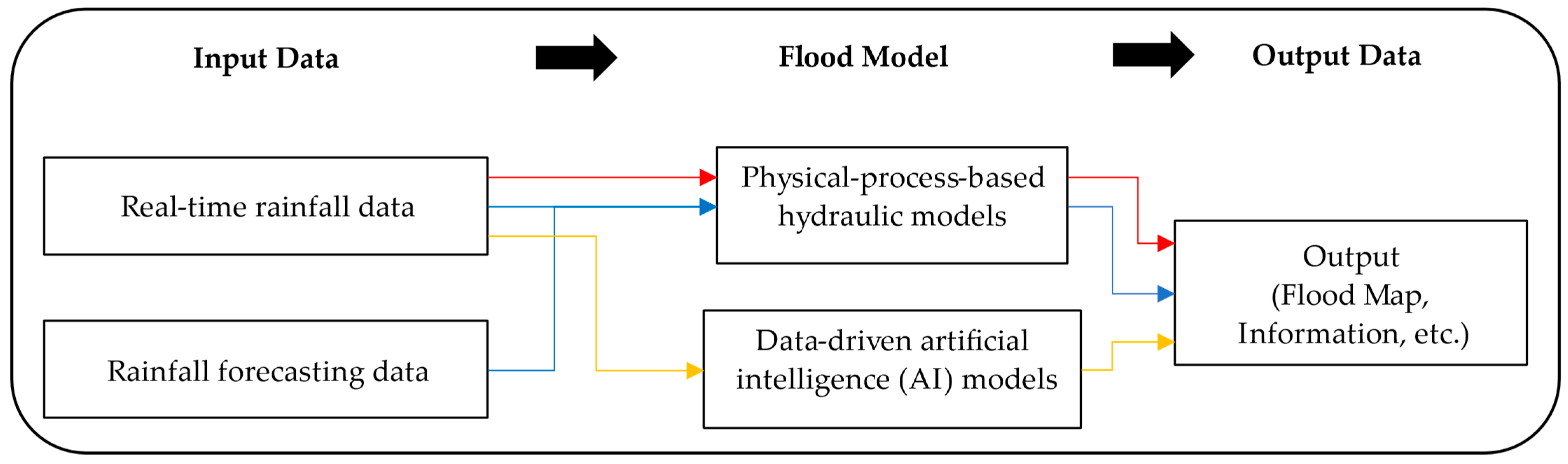
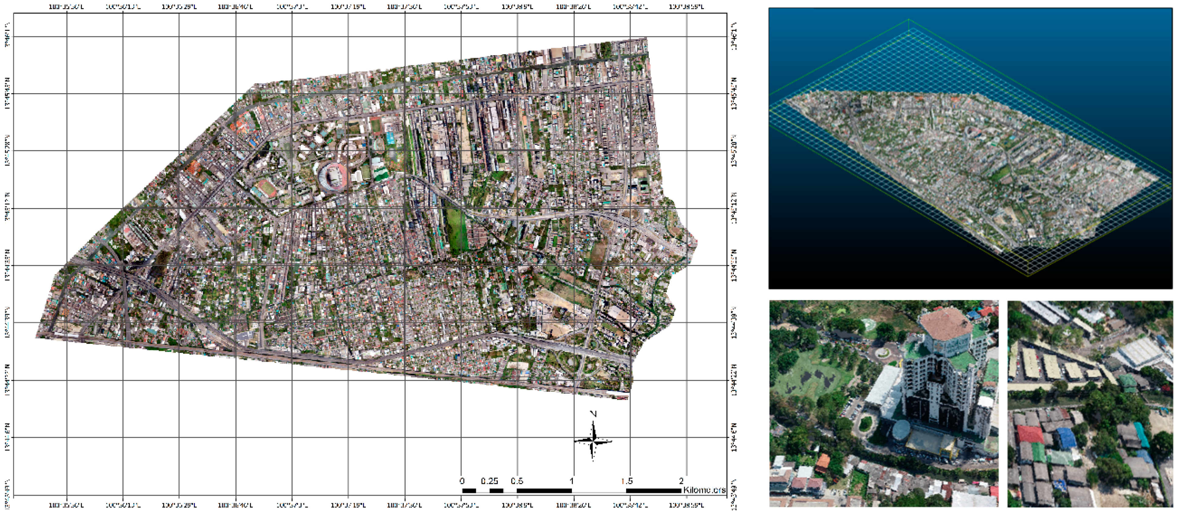
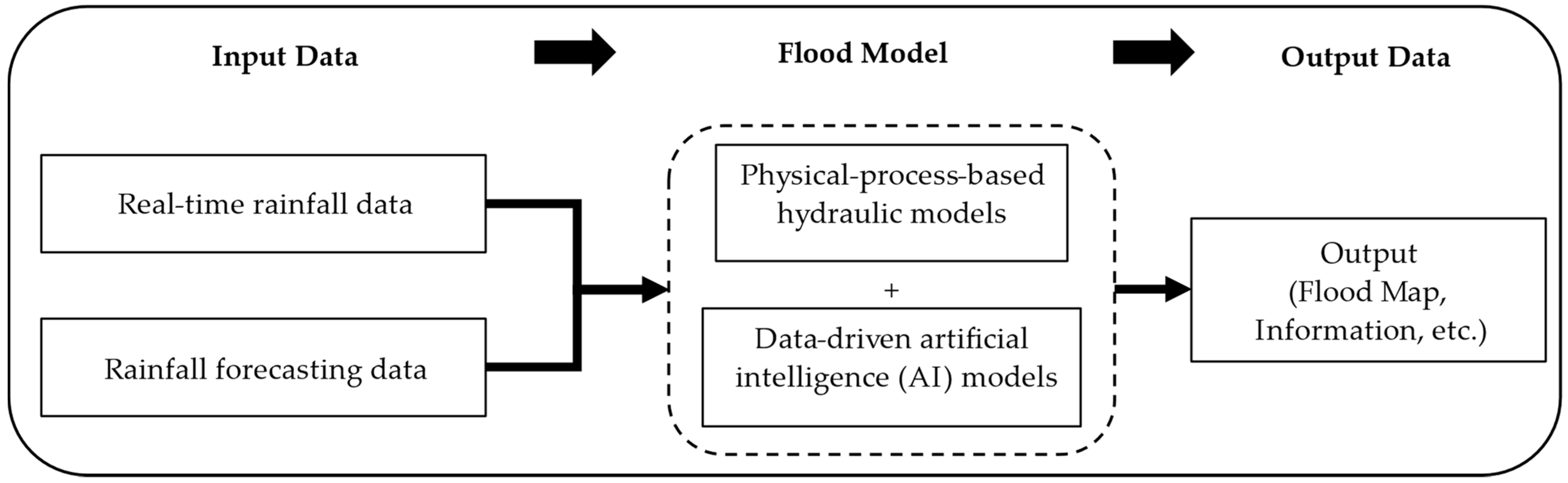
Table 1.
Recent research on physical-process-based models for real-time urban flood forecasting systems.
Table 1.
Recent research on physical-process-based models for real-time urban flood forecasting systems.
| Country | Area (km2) | Hydraulic Modelling Method | References |
|---|---|---|---|
| Germany | 1.68 | SWMM | [108] |
| France | 0.3 | SWMM | [109] |
| Australia | 45 | MIKE urban | [110] |
| USA | 696.7 | SWMM | [111] |
| Denmark | 1.48 | MIKE urban | [112] |
| Brazil | 0.11 | SWMM | [113] |
| China | 0.017 | SWMM, MIKE 21 | [114] |
| USA | 0.11 | RBC SWMM | [115] |
| China | 141.09 | SWMM | [116] |
| UK | N/A | Shetran | [117] |
| Nepal | 51.94 | PCSWMM | [118] |
| Thailand | 11 | PCSWMM | [80] |
Table 2.
Recent research on data-driven AI models for real-time urban flood forecasting systems.
| Country | Area (km2) | Hydraulic Modelling Method | Data-Driven AI Model | References |
|---|---|---|---|---|
| France | 0.3 | SWMM | ANN | [109] |
| Belgium | 0.3 | - | ANN | [143] |
| Norway | 15 | - | LSTM, GRU | [144] |
| UK | N/A | - | LASSO, ANN | [145] |
| South Korea | 6.8 | - | CNM | [146] |
| Germany | N/A | - | CNM, I-Tree Canopy method | [147] |
| UK | 21.80 | - | URMOD | [148] |
| Germany | 4.0 | MIKE 21 | GAN | [149] |
Disclaimer/Publisher’s Note: The statements, opinions and data contained in all publications are solely those of the individual author(s) and contributor(s) and not of MDPI and/or the editor(s). MDPI and/or the editor(s) disclaim responsibility for any injury to people or property resulting from any ideas, methods, instructions or products referred to in the content. |
© 2023 by the authors. Licensee MDPI, Basel, Switzerland. This article is an open access article distributed under the terms and conditions of the Creative Commons Attribution (CC BY) license (https://creativecommons.org/licenses/by/4.0/).
Share and Cite
MDPI and ACS Style
Chitwatkulsiri, D.; Miyamoto, H. Real-Time Urban Flood Forecasting Systems for Southeast Asia—A Review of Present Modelling and Its Future Prospects. Water 2023, 15, 178. https://doi.org/10.3390/w15010178
AMA Style
Chitwatkulsiri D, Miyamoto H. Real-Time Urban Flood Forecasting Systems for Southeast Asia—A Review of Present Modelling and Its Future Prospects. Water. 2023; 15(1):178. https://doi.org/10.3390/w15010178
Chicago/Turabian StyleChitwatkulsiri, Detchphol, and Hitoshi Miyamoto. 2023. "Real-Time Urban Flood Forecasting Systems for Southeast Asia—A Review of Present Modelling and Its Future Prospects" Water 15, no. 1: 178. https://doi.org/10.3390/w15010178
Note that from the first issue of 2016, this journal uses article numbers instead of page numbers. See further details here.