
Development Patterns of Fractured Water-Conducting Zones under Fully Mechanized Mining in Wet-Collapsible Loess Area
1
Ecological Environment Technology Co., Ltd., China Coal Technology and Engineering Group, Beijing 100013, China
2
School of Safety Engineering, North China Institute of Science and Technology, Beijing 101601, China
3
School of Ecological Environment, Institute of Disaster Prevention, Sanhe 065201, China
*
Author to whom correspondence should be addressed.
Water 2023, 15(1), 22; https://doi.org/10.3390/w15010022
Submission received: 3 November 2022
/
Revised: 16 December 2022
/
Accepted: 17 December 2022
/
Published: 21 December 2022
(This article belongs to the Section Hydrogeology)
Abstract
:The development pattern of fractured water-conducting zones (FWCZs) is closely related to mining safety and water conservation in mining areas. However, neither the development pattern nor the empirical formula in the prediction of the height of FWCZs are clear for fully mechanized caving mining conditions in wet collapsible loess areas. We took Lu’an Coal Mine as a case study, employing field measurements and numerical simulation to investigate surface subsidence and FWCZs. Under the conditions of fully mechanized top coal caving in thick coal seams, surface movement is more intense, and surface cracking is more frequent. Field measurements using boreholes indicated the ratio of fracture height to coal seam thickness was 19.1–23.4, and the ratio stays stable both by sliced fully mechanized mining and fully mechanized mining. The height of the FWCZ with fully mechanized mining is 1.37 times and 2.31 times larger than the height with sliced fully mechanized mining and ordinary mining, respectively. The numerical simulation by RFPA illustrated that the height of the FWCZ remained stable when it reached a certain rock level with the working face moving forward. Furthermore, we developed an empirical formula for predicating the maximum height of an FWCZ under fully mechanized mining conditions in wet collapsible loess areas. Finally, the research findings were applied in several coal mines to achieve safe production and water conservation. This work provides guidance for effectively mining safely and water conservation in similar geographic conditions.
1. Introduction
The process of coal mining breaks the overlying rock layer and forms fractured water-conducting zones (FWCZs). The water-conducting pathways with water sources may cause an inrush of water in coal mining [1,2,3]. Aquifers or surface water can gush into the working face through water-conducting fissures, threatening safety in coal mining productions and causing significant social and economic losses and casualties [4,5,6,7]. At the same time, the loss of water resources destroys the ecological balance in the mining area, causing a decline in the diversity and stability of the vegetation surrounding the mine [8,9]. Therefore, the observation and modeling of FWCZs can provide important information to ensure sustainable mining production and ecological protection in mining areas.
The overlying strata are usually divided into three distinct zones according to the deformation and failure characteristics of the overlying strata: caved, fractured and continuous deformation zones [10]. The combination of fractured and caved zones forms FWCZs [11]. Scholars have developed several methods for calculating the height of an FWCZ and researched the evolution pattern in different geological mining conditions via field observation, theoretical derivation, empirical formulae and numerical simulation. Majdi et al., considering the high-pressure relief zone that forms after coal seam mining, derived mathematical methods to estimate the maximum value of an FWCZ [12]. Miao et al. found the breakage of key strata may enhance the final fracture height in strata, resulting in exceptional fracture zone phenomena [13]. Hou et al. applied seismic identification technology to identify the development of FWCZs [14]. Yao et al. analyzed the influence of mining overburden off-layer grouting on FWCZs [15]. Luan et al. studied the development of FWCZs in close repetitive mining using an empirical formula and Flac3D numerical simulation [16]. Wei et al. revealed the development of an FWCZ and its influencing factors under multi-seam mining [17]. Wu et al. combined GIS methods and ANN to evaluate the vulnerability of the water inrush for coalmines and the effects of geologic and hydrogeologic factors on the water inrush [18,19]. These studies indicate that the height of the FWCZ is affected by multiple factors, such as the coal mining process, mining depth, mining panel width (or length), mining thickness, roof overburden structure and geological conditions.
The coal mining process is an important factor affecting surface subsidence and the height of FWCZs. At present, there are three main mining methods, namely: ordinary mining, sliced fully mechanized mining, and fully mechanized mining. Fully mechanized mining has the highest efficiency in mining thick coal seams. Therefore, fully mechanized mining has become popular. However, fully mechanized mining causes serious damage to the surface and overburdening, lead to full development of an FWCZ, which poses a great challenge for water conservation in coal mining. Thus, elucidating the development pattern of FWCZs has attracted many researchers’ attention. Sheng and Duan developed a formula for calculating the height of an FWCZ in fully mechanized mining conditions under a thick sandstone aquifer based on actual measurement data [20]. Fan and Zhao identified the height of the FWCZ of the Xindeng Coal Mine via borehole leakage measurement, television imager and simulation experiments [21]. Li applied a cubic function polynomial curve to predict the height of an FWCZ under fully mechanized mining [22]. However, there is a lack of research on the dynamic development of FWCZs under mining conditions with a hard overlying rock layer, shallow burial depth (burial depth < 200 m) and a submerged loess layer.
To solve this problem, we employed field measurements and numerical simulation to study surface subsidence and the development pattern of the FWCZ in Lu’an Coal Mine. This study provides a reference for coal mining with water conversion under similar geological conditions to reduce mining damage, improve the economic benefits, and realize sustainable development of the mining area.
2. Study Region and Geological Conditions
The Lu’an mining area is located in southeastern Shanxi Province and is jointly controlled by Xiangheng County, Dunliu County, Lucheng County, Changzhi County and Changzi County. Figure 1 shows the geographical location and distribution of the Lu’an mining area, including Wuyang, Xiadian, Wangzhuang, Changcun, Yuwu, Guozhuang, Gaohe, Huoerxinhe, Sima and other mining areas. The mining area totals 1182.5 km2 with an annual production capacity of 50 million tons. Surface water is abundant in the mining area, deriving from sources such as the Zhanghe River, Jianghe River, Zhangze Reservoir and Changlong Reservoir. There are almost 181 million tons of coal resources trapped under the water.
As Table 1 shows, the stratigraphy of the Lu’an mining area, from the oldest layers to the newest, includes the Middle Ordovician Fengfeng Group (O2f), the Middle Carboniferous Benxi Group (C2b), the Upper Taiyuan Group (C3t), the Lower Ditian Shanxi Group (P1s), the Lower Ditian Lower Shi Box Group (P1x), the Upper Ditian Upper Shi Box Group (P2s) and the loose Quaternary layer. The mining seam is mainly found in the lower Permian 3# formation, which is about 6 m thick, with a coal bed pitch of 3–10 m. Generally, the disposal full-thickness mining technique under fully mechanized top coal caving conditions is often applied, and the roof is managed using the full-collapse method. The overlaying rock aquifer is found in the 3# coal seam roof (K8 and K10 aquifers), bedrock weathering zone and loose Quaternary layer. The sandstone fissure aquifers above the coal seam roof mainly have a static storage capacity, and the water-filled channels are formed by mining fissures and tectonic fracture zones. The sandstone fissure aquifers above the coal seam roof have no effect on mine safety production because they contain a limited amount of water. Surface water bodies are the main water safety hazard in mining.
3. Results and Discussion
3.1. Characters of Surface Subsidence
In order to protect hydraulic structures (dikes, spillways, sluices, aqueduct troughs, etc.) in surface water bodies (rivers, reservoirs), the study of surface movement and fractures is an important part of research on coal mining under water bodies.
- (1)
- The surface deformation
With extensive fully mechanized mining applications, Lu’an Mine constructed surface rock shift stations successively in Wuyang, Wangzhuang, Sima, Changcun, Gaohe, Guozhuang and Xiadian. Rock shift under different geological conditions has been observed and studied for a long time, leading to valuable and significant results [23,24].
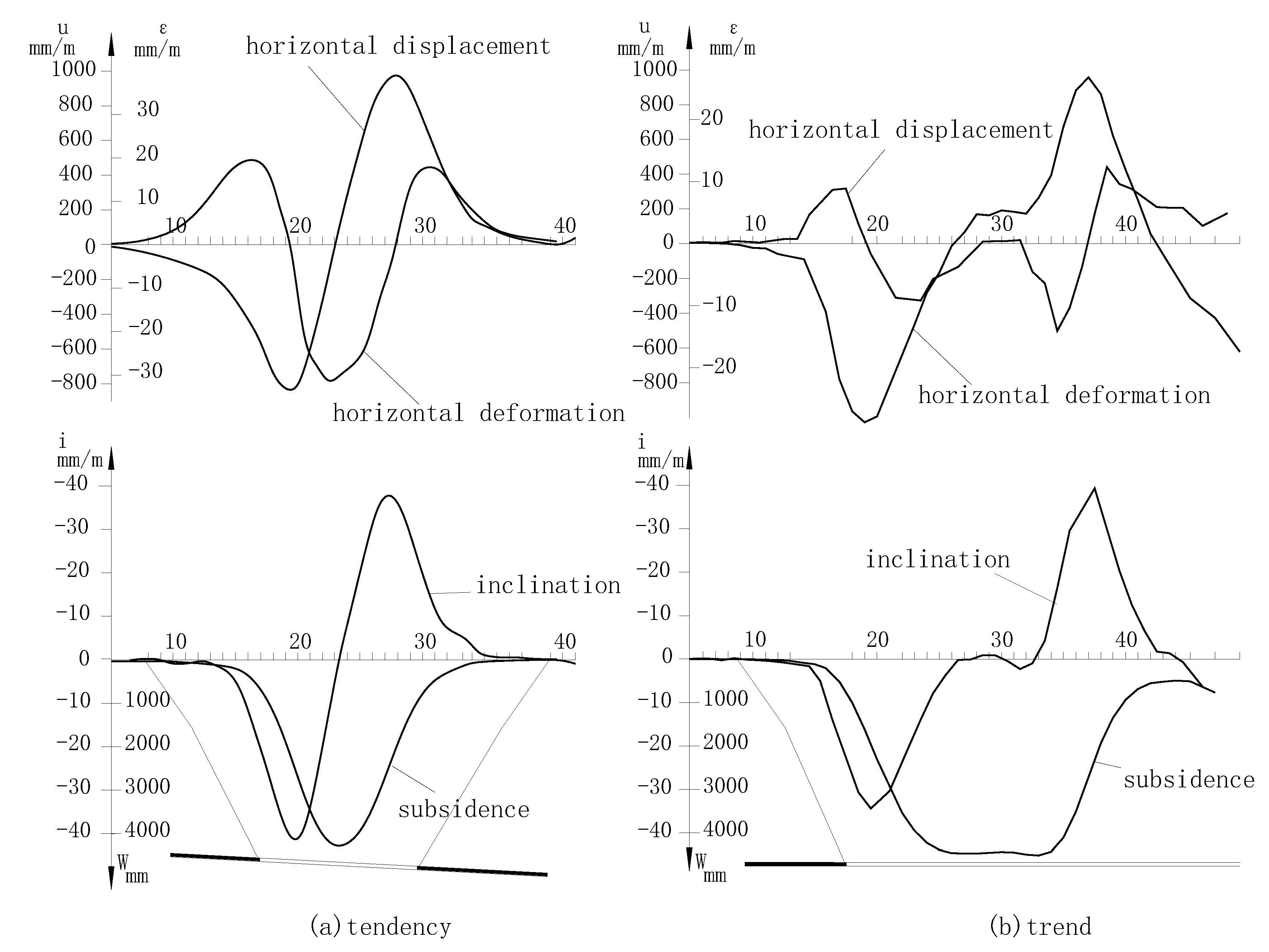
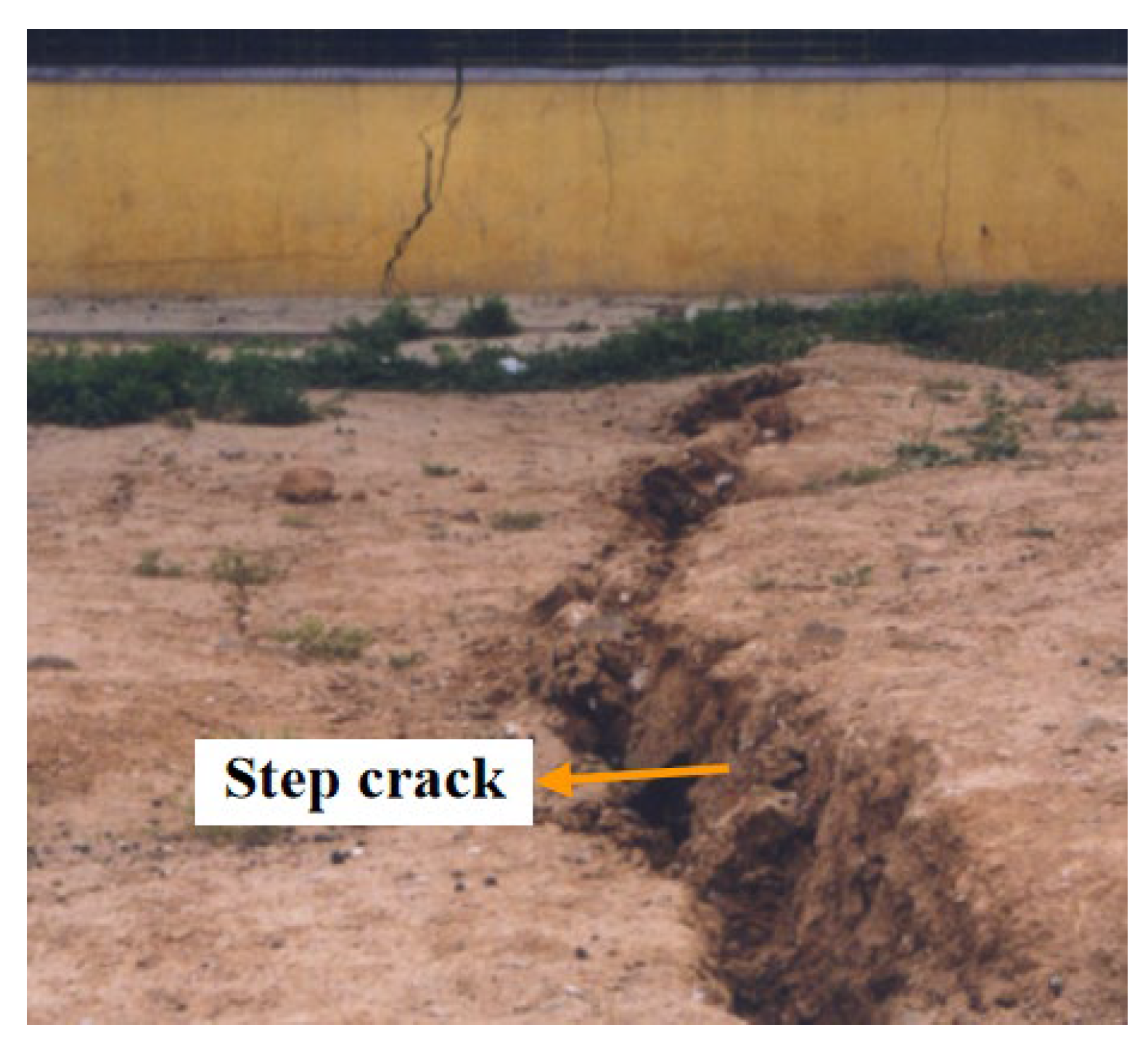
According to measurement data, the movement deformation of the surface under fully mechanized mining is significant. For the 6206 working face of Wangzhuang Coal Mine, the maximum subsidence, the maximum tilt threshold, the maximum horizontal movement, the maximum positive curvature, the maximum negative curvature, the maximum horizontal tensile deformation and the maximum horizontal compressive deformation are 4534 mm, 42.4 mm/m, 1060 mm, 0.78 × 10⁻³ m, −0.98 × 10⁻³ m, 12.48 mm/m and 18.3 mm/m, respectively (Figure 2). The surface subsidence basin is very steep, and there has been relatively extensive development of surface fissures (Figure 3).
- (2)
- Parameters of the probability integral method
The data for surface movement and deformation support the prediction of surface coal mining subsidence. The probabilistic integral method is widely used to make predictions in China as it provides a clear mathematical model and is a mature construction method. Thus, we calculated the specific parameters of the probability integral prediction method according to measurement data from different observation stations in Lu’an Mine. Under fully mechanized mining conditions, the average subsidence coefficient, horizontal movement coefficient, tangent of dominant influence angle, deviation of inflection point and propagation angle of the extraction coefficient in the study area were calculated as 0.83, 0.28, 2.67, 0.11 and 0.6, respectively. The results indicate the subsidence coefficient and tangent of the dominant influence angle in fully mechanized top coal caving operations with wet, sinking loess cover and thick coal seam conditions.
3.2. Overburden Failure Law
- (1)
- Measurement of overburden failure
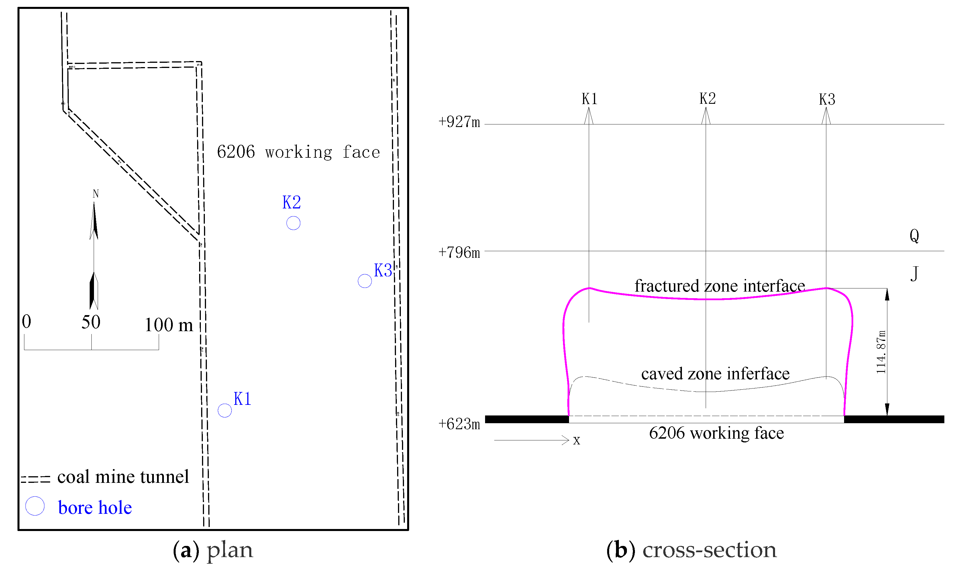
The overburden failure law and development rules of the FWCZ in the Wuyang, Wangzhuang, Guozhuang and Gaohe in Luan Mine under fully mechanized top coal caving conditions were observed [25,26,27]. Drilling holes were made to observe the fissures in the roof of the mining area. Figure 4 displays the drilling holes in the 6206 working face of Wangzhuang Coal Mine. Table 2 shows the height of the FWCZ under sliced fully mechanized mining and fully mechanized mining conditions. Additionally, the operation was not found to be affected by adjacent operations. All the mining seams are located in the lower Permian 3# formations.
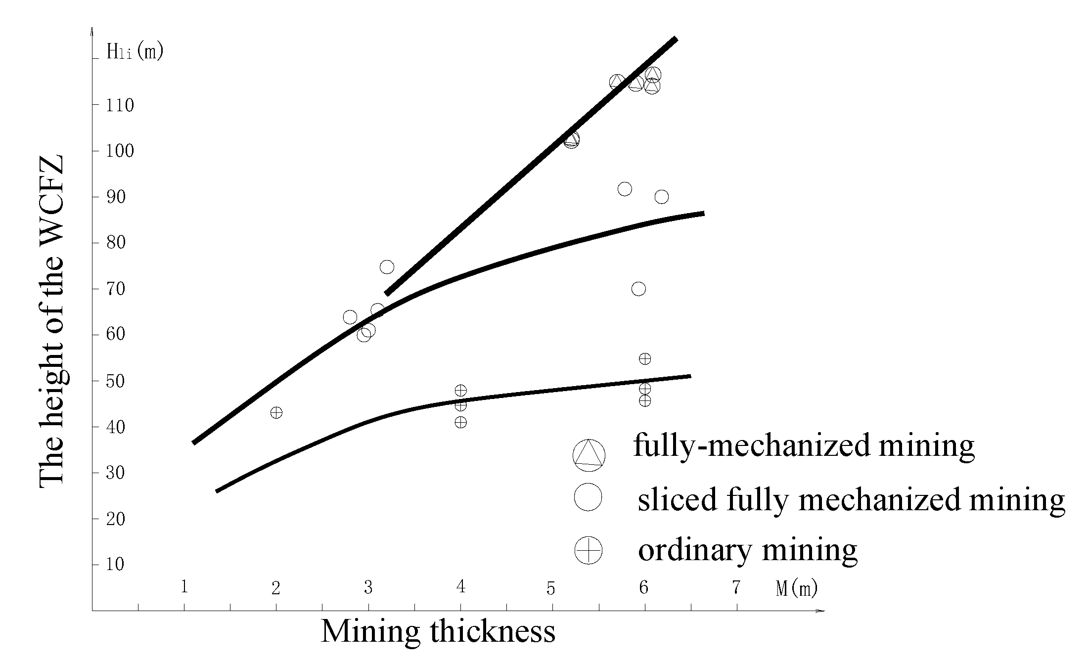
According to a comprehensive analysis of the data on overburden failure in the study area, the thickness-to-height ratio established in sliced fully mechanized mining operations is similar to that in fully mechanized mining operations. The thickness-to-height ratio in the study area was concentrated in a range of 19.1~23.4, reflecting the development pattern of the FWCZ under fully mechanized mining conditions. The relationship between the height of the FWCZ and the mining thickness of the 3# coal seam in the study area under different mining conditions is shown in Figure 5.
The height of the FWCZ under fully mechanized mining conditions was significantly greater than those under ordinary mining and sliced fully mechanized mining conditions [28,29]. The maximum heights of FWCZs under ordinary mining, sliced fully mechanized mining and fully mechanized mining conditions were 49.6 m, 83.9 m and 114.67 m, respectively. Given the same conditions, the maximum height of FWCZ under fully mechanized mining is 1.37 times that under sliced fully mechanized mining conditions and it is 2.31 times that under ordinary mining conditions.
The height of the FWCZ under fully mechanized mining conditions was relatively proportional to the thickness of the coal seam in disposal mining, and it had a similar development rule to that of the FWCZ under sliced fully mechanized mining conditions. The thickness-to-height ratio in fully mechanized full-seam mining conditions ranges from 19.1 to 20.2, while the thickness-to-height ratio under sliced fully mechanized mining conditions ranges from 20.3 to 23.4. The thickness-to-height ratio of the initial layer under sliced fully mechanized mining conditions was 21.6. The thickness-to-height ratios under three different conditions were uniform.
- (2)
- Numerical simulation analysis
A numerical simulation by a rock fracture process analysis (RFPA) system is usually applied to explore the movement of overlaying strata [30,31]. The procedure for this was as follows: (1) the nonlinear behaviors of macroscopic deformation and failure of rocks were simulated considering the anisotropism of microscale mechanical parameters (e.g., elasticity modulus and strength); (2) discontinuity and irreversible behaviors of materials were simulated considering parameter weakening of units after material failure (rigidity degeneration). The RFPA system can simulate the whole collapse process by advancing the working face intuitively.
To build the model, thin rock strata with similar properties were chosen and combined in modeling. The bedding among different rock strata was pre-set, and the elements were set as homogeneous isotropic collinear elastic brittle bodies in the system. Each rock stratum was non-homogeneous, and the mechanical parameters (e.g., elasticity modulus and compressive strength) all conformed to the Weibull distribution. The simulation results for overburden failure in the full-seam mining working face in Lu’an Mine under fully mechanized mining conditions are shown in Figure 6.
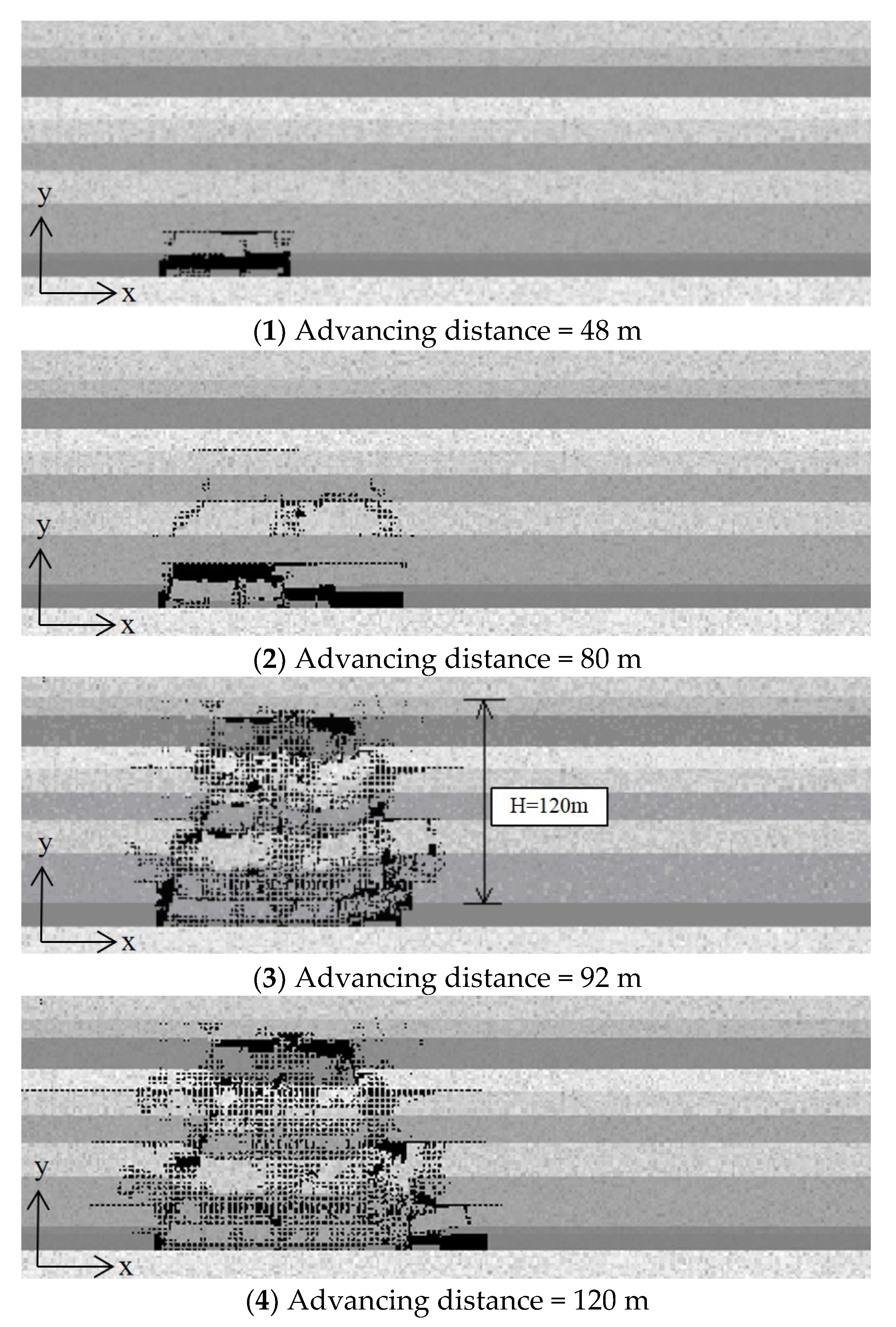
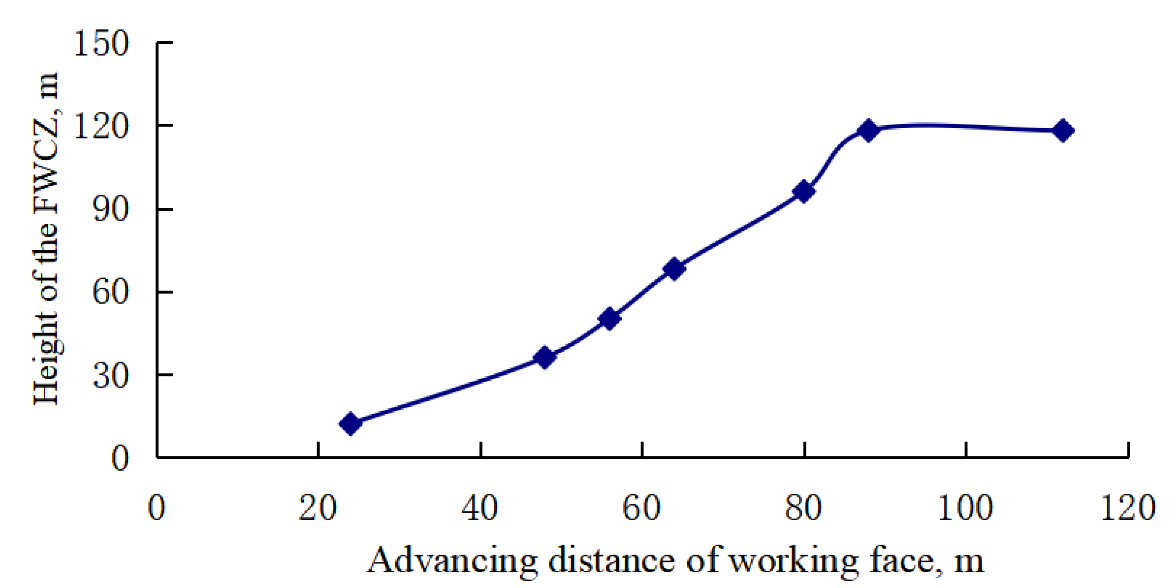
It can be seen from the numerical simulation results that the FWCZ in overlying strata develops continuously toward the upper rock strata as the working face advances from the open-off cut. As the working face advances continuously, the height of the FWCZ is extended to a rock stratum, and it becomes relatively stable. The relationship between the height of the FWCZ and the advancing distance of the working face is shown in Figure 7. The top roof develops periodic movement as the working face advances continuously. The failure mechanisms of direct roofs and old roofs are tensile failure modes caused by mining-induced tensile stress.
The dynamic development of overburden failure of a 3# coal seam in Lu’an Mine under fully mechanized mining conditions was simulated. The final height of the FWCZ was about 120 m.
- (3)
- Maximum height of FWCZ under fully mechanized mining
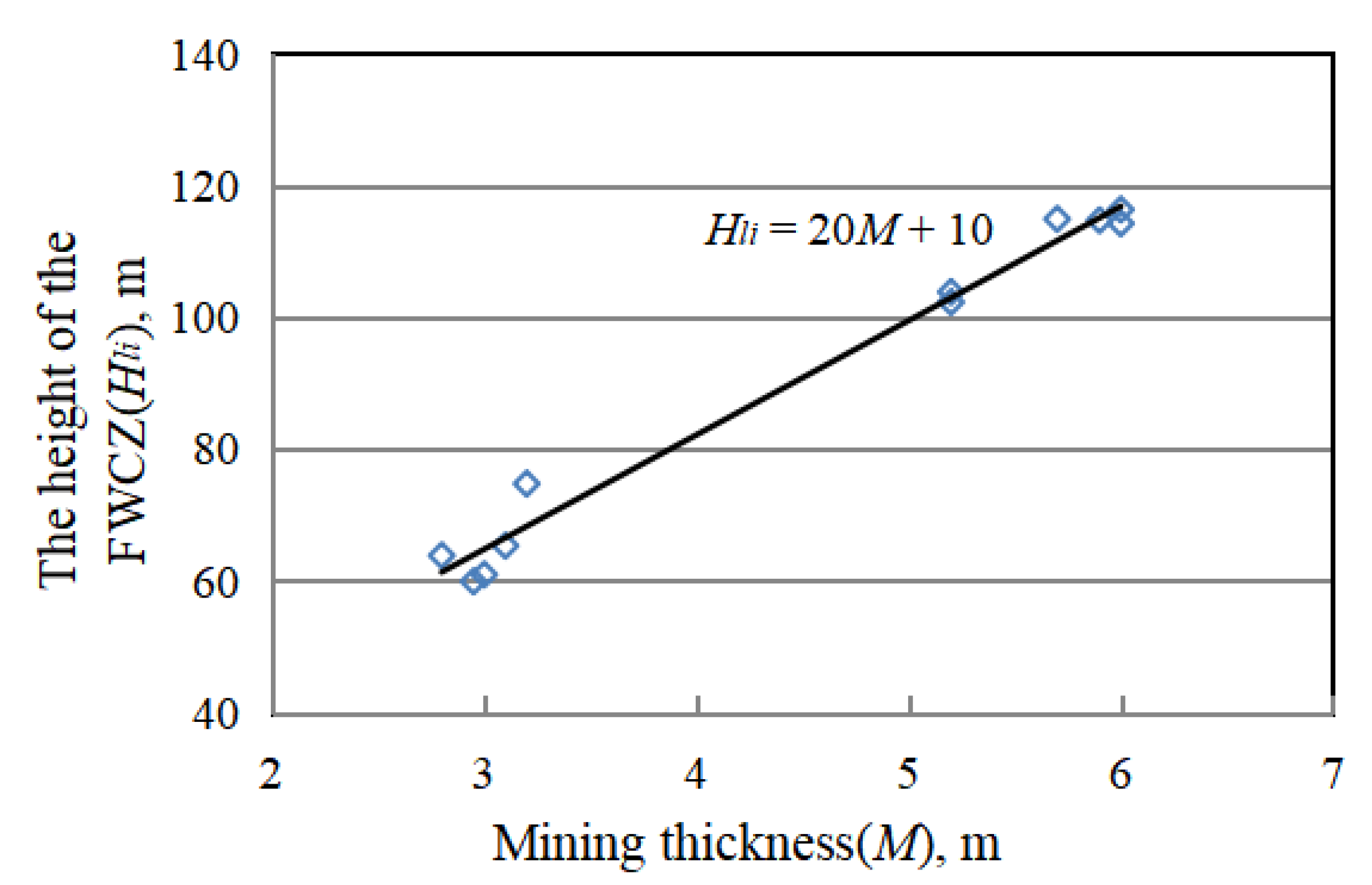
The scattered point distribution relationship between the measured height of the FWCZ and mining thickness under sliced fully mechanized mining conditions and fully mechanized mining conditions is shown in Figure 8.
According to the measurement of overburden failure in Lu’an Mine, the calculation formula of the maximum height of a FWCZ under fully mechanized mining was proposed by the regression method with references to theoretical analysis and numerical simulation results.
where M (m) is the effective mining thickness of the coal seam, and Hli (m) is the maximum height of the FWCZ.
Hli = 20 M + 10
4. Case Study
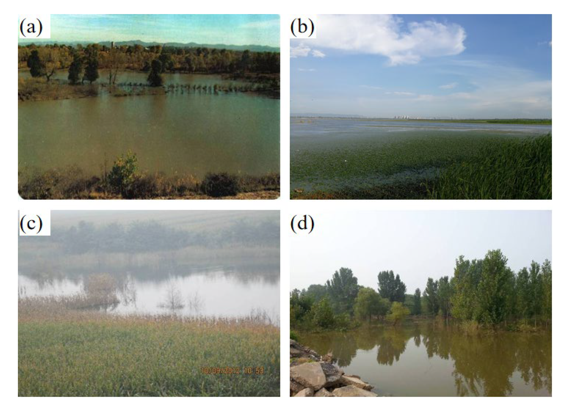
Based on our research, many coal mines with fully mechanized mining operations under surface water have achieved safe mining conditions, including Wuyang Coal, Wangzhuang Coal, Gaohe Coal, and Guozhuang Coal in Lu’an Mine. Figure 9 illustrates the surface conditions in the coal mines. We take Wuyang and Wangzhuang coals as examples. In Wuyang Coal, working faces 7802, 7806, 7808, 7800 and 7522 were exploited west of the Zhuozhuang River. The thickness, dip angle and minimum mining depth of the coal seam were 5.5–6.80 m, 6–8° and 245 m, respectively. The bedrock in some regions was exposed. We calculated the maximum height of the FWCZ as 120 m~146 m according to the formula of maximum height of the FWCZ. Three layers of laminated mudstone with a thickness of more than 15 m exist below the riverbed and above the top interface of the hydraulic fracture zone, maintaining the original water barrier, and thus greatly limiting the expansion of the hydraulic fracture zone to the upper rock layer and blocking the infiltration and recharge of the overlying water body. When mining under the riverbed, the amount of gushing water reaches about 10 to 20 m3 per hour, and the river does not have obvious leakage.
In Wangzhuang Coal, the open-off cut of the 8110 working face is below the Zhangze Reservoir, which is a large reservoir with a capacity of 250 million m3. The overlying rocks of the working face are soft and hard interaction structures, comprising a laminated bedrock stratum of medium and fine sandstone, siltstone, sandy mudstone and mudstone. The maximum mining thickness of the 8110 working face is 6 m; according to Formula 1, the FWCZ of the working face is 130 m high. This result provides guidance for the retention of safe waterproof coal rock pillars and the value of the thickness of the protective layer. During mining of the 8110 working face, the gushing water in the working face is the roof plate fracture sandstone water, the amount of gushing water is normal, generally 20 m3/h, and no abnormal increase in gushing water occurred.
5. Conclusions
- (1)
- The subsidence law of the collapsibility of a loess layer under fully mechanized top coal caving conditions was discussed systematically. Different rock shift parameters were calculated. We found that there is strong surface movement under fully mechanized top coal caving of thick coal seams, accompanied by surface subsidence, steep basins and concentration movement deformation. The coefficient of subsidence and tangent of the dominant influence angle are relatively large, and there is extensive development of surface fissures.
- (2)
- The overburden failure law and development rule of FWCZs under fully mechanized mining of thick coal seams were explored. According to field measurements and theoretical analysis, a formula for obtaining the maximum height of FWCZs in moderate and hard overlying rocks under fully mechanized mining conditions is proposed.
- (3)
- Technology for fully mechanized mining operations under water was studied systematically. Large-scale mining projects have been carried out in Wuyang Coal, Wangzhuang Coal, Gaohe Coal and Guozhuang Coal in Lu’an Mine, which have achieved outstanding economic and social benefits.
Author Contributions
Y.T. conceptualized and designed the study; Y.T., S.Y. and W.Z. performed formal analysis and wrote the original draft; S.J. reviewed and edited the paper. All authors have read and agreed to the published version of the manuscript.
Funding
This study was supported by Science and Technology Innovation Fund of Ecological Environment Technology Co., Ltd., CCTEG (Grant No. 0206KGST0005) and National Natural Science Foundation of China (Grants No. 52274165).
Data Availability Statement
Data sharing is not applicable to this article.
Conflicts of Interest
The authors declare no conflict of interest.
References
- Ma, D.; Duan, H.; Zhang, J.; Bai, H. A State-of-the-Art Review on Rock Seepage Mechanism of Water Inrush Disaster in Coal Mines. Int. J. Coal Sci. Technol. 2022, 9, 50. [Google Scholar] [CrossRef]
- Ma, D.; Duan, H.; Zhang, J.; Liu, X.; Li, Z. Numerical Simulation of Water–Silt Inrush Hazard of Fault Rock: A Three-Phase Flow Model. Rock Mech. Rock Eng. 2022, 55, 5163–5182. [Google Scholar] [CrossRef]
- Ma, D.; Duan, H.; Zhang, J. Solid Grain Migration on Hydraulic Properties of Fault Rocks in Underground Mining Tunnel: Radial Seepage Experiments and Verification of Permeability Prediction. Tunn. Undergr. Space Technol. 2022, 126, 104525. [Google Scholar] [CrossRef]
- Zhang, J.; Shen, B. Coal Mining under Aquifers in China: A Case Study. Int. J. Rock Mech. Min. Sci. 2004, 41, 629–639. [Google Scholar] [CrossRef]
- Wu, Q.; Wang, M.; Wu, X. Investigations of Groundwater Bursting into Coal Mine Seam Floors from Fault Zones. Int. J. Rock Mech. Min. Sci. 2004, 41, 557–571. [Google Scholar] [CrossRef]
- Wang, J.; Park, H.D. Coal Mining above a Confined Aquifer. Int. J. Rock Mech. Min. Sci. 2003, 40, 537–551. [Google Scholar] [CrossRef]
- Yi, S.; Zhang, Y.; Yi, H.; Li, X.; Wang, X.; Wang, Y.; Chu, T. Study on the Instability Activation Mechanism and Deformation Law of Surrounding Rock Affected by Water Immersion in Goafs. Water 2022, 14, 3250. [Google Scholar] [CrossRef]
- Li, W.; Wang, Q.; Liu, S.; Pei, Y. Study on the Creep Permeability of Mining-Cracked N2 Laterite as the Key Aquifuge for Preserving Water Resources in Northwestern China. Int. J. Coal Sci. Technol. 2018, 5, 315–327. [Google Scholar] [CrossRef] [Green Version]
- Sun, K.; Fan, L.; Xia, Y.; Li, C.; Chen, J.; Gao, S.; Wu, B.; Peng, J.; Ji, Y. Impact of Coal Mining on Groundwater of Luohe Formation in Binchang Mining Area. Int. J. Coal Sci. Technol. 2021, 8, 88–102. [Google Scholar] [CrossRef]
- Palchik, V. Formation of Fractured Zones in Overburden Due to Longwall Mining. Environ. Geol. 2003, 44, 28–38. [Google Scholar] [CrossRef]
- Adhikary, D.P.; Guo, H. Measurement of Longwall Mining Induced Strata Permeability. Geotech. Geol. Eng. 2014, 32, 617–626. [Google Scholar] [CrossRef]
- Majdi, A.; Hassani, F.P.; Nasiri, M.Y. Prediction of the Height of Destressed Zone above the Mined Panel Roof in Longwall Coal Mining. Int. J. Coal Geol. 2012, 98, 62–72. [Google Scholar] [CrossRef]
- Miao, X.; Cui, X.; Wang, J.; Xu, J. The Height of Fractured Water-Conducting Zone in Undermined Rock Strata. Eng. Geol. 2011, 120, 32–39. [Google Scholar] [CrossRef]
- Hou, E.; Yuan, F.; Wang, S.; Xie, X.; Wu, B. Seismic Identification and Development Characteristics of Water Conducting Fissure Zone in Goaf. J. China Coal Soc. 2022. [Google Scholar] [CrossRef]
- Yao, W.; Kou, T.; Fan, B.; Gao, Z.; Yue, P.; Wen, S. Influence Evaluation of Mining-induced Strata Separation Grouting on Mine Safety. Coal Technol. 2022, 41, 170–174. [Google Scholar] [CrossRef]
- Luan, Y.; Yu, S.; Guo, C.; Guo, K.; Shi, Y.; Dong, Y.; Luan, H. Study on Development of Water-flow Fractured Zone during Closedistance Repeated Coal Mining. Coal Technol. 2022, 41, 115–118. [Google Scholar] [CrossRef]
- Wei, S.; Zhao, Y.; Qi, C.; Tao, S. On Development Law of Water Conducting Fracture Zone and Overburden Failure Height in Multi-Coal Seam Mining. J. Hunan Univ. Sci. Technol. Sci. Ed. 2022, 37, 18–26. [Google Scholar] [CrossRef]
- Wu, Q.; Xu, H.; Pang, W. GIS and ANN Coupling Model: An Innovative Approach to Evaluate Vulnerability of Karst Water Inrush in Coalmines of North China. Environ. Geol. 2008, 54, 937–943. [Google Scholar] [CrossRef]
- Wu, Q.; Zhou, W.; Wang, J.; Xie, S. Prediction of Groundwater Inrush into Coal Mines from Aquifers Underlying the Coal Seams in China: Application of Vulnerability Index Method to Zhangcun Coal Mine, China. Environ. Geol. 2009, 57, 1187–1195. [Google Scholar] [CrossRef]
- Sheng, F.; Duan, Y. Height of water-conducting fracture zone in fully mechanized caving mining under extra-thick sandstone aquifer in Binchang mining area. Coal Eng. 2022, 54, 84–89. [Google Scholar]
- Fan, Z.; Zhao, Z.; Yuan, R.; Wu, J. Study on Development Height of Water Flowing Fractured Zone in Fully Mechanized Top Coal Caving Mining of Xindeng Coal Mine. Coal Technol. 2022, 41, 152–154. [Google Scholar] [CrossRef]
- Li, C. Formula for Predicting Height of Water Flowing Fractured Zone Caused during Fully-Mechanized Caving Mining in Huanglong Coalfield. Coal Technol. 2021, 40, 119–122. [Google Scholar] [CrossRef]
- Teng, Y.; Wang, J. The law and mechanism of ground subsidence induced by coal mining using fully-mechanized caving method. J. China Coal Soc. 2008, 33, 264–267. [Google Scholar]
- Teng, Y.; Tang, Z.; Zheng, Z. Research and Application of Surface Subsidence Law of Fully-Mechanized Top Coal Caving; Coal Industry Press: Beijing, China, 2009; ISBN 978-7-5020-3607-2. [Google Scholar]
- Yang, J.; Teng, Y. Study on Development Law of Water Conducted Fracture Zone in Top Coal of Fully Mechanized Top Coal Caving Mining Face. Coal Sci. Technol. 2009, 37, 100–102. [Google Scholar] [CrossRef]
- Teng, Y. Development Features and Max Height Calculation of Water Conducted Fractured Zone Caused by Fully Mechanized Top Coal Caving Mining. Coal Sci. Technol. 2011, 39, 118–120. [Google Scholar] [CrossRef]
- Teng, Y.; Yang, J.; Zhuan, W.; Zhang, H. Study on the Mechanism and laws of Overburden Failure under Fully Mechanized Top Coal Mining. Mine Surv. 2010, 38, 32–34+4. [Google Scholar]
- Kang, Y. The effect of various mining methods on development law of water flowing fractured zone. J. China Coal Soc. 1998, 23, 40–44. [Google Scholar]
- Hu, G.; Li, W.; Cheng, W.; Zheng, Z. Study on the Law of Fractured Full-mechanized Caving mining in Huainan Coal. Coal Eng. 2008, 55, 74–76. [Google Scholar]
- Tang, C.; Xu, T. Rock Failure Process Analysis Method (RFPA) for Modeling Coal Strata Movement. In Advances in Coal Mine Ground Control; Peng, S.S., Ed.; Woodhead Publishing Series in Energy; Woodhead Publishing: Sawston, UK, 2017; pp. 345–377. ISBN 978-0-08-101225-3. [Google Scholar]
- Yu, X.; Zhao, K.; Wang, Q.; Yan, Y.; Zhang, Y.; Wang, J. Relationship between Movement Laws of the Overlaying Strata and Time Space of the Mined-Out Volume. Geofluids 2020, 2020, e2854187. [Google Scholar] [CrossRef]
Figure 1.
Geographical location and distribution of mining area.

Figure 2.
The deformation curve of the surface of the 6206 working face in Wangzhuang Coal Mine: (a) tendency, (b) trend.
Figure 2.
The deformation curve of the surface of the 6206 working face in Wangzhuang Coal Mine: (a) tendency, (b) trend.

Figure 3.
Surface step cracks in 6206 working face of Wangzhuang Coal Mine.

Figure 4.
The locations of three drilling holes in the 6206 working face of Wangzhuang Coal Mine.

Figure 5.
Relation between height of FWCZ and thickness of the same coal seam under different mining conditions.
Figure 5.
Relation between height of FWCZ and thickness of the same coal seam under different mining conditions.

Figure 6.
Dynamic simulation of overburden failure under fully mechanized mining conditions.

Figure 7.
Relationship between height of the FWCZ and advancing distance of working face under fully mechanized mining conditions.
Figure 7.
Relationship between height of the FWCZ and advancing distance of working face under fully mechanized mining conditions.

Figure 8.
Relationship between height of FWCZ and mining thickness.

Figure 9.
Coal mining under water. (a) Wuyang Coal (b) Wangzhuang Coal (c) Gaohe Coal (d) Guozhuang Coal.
Figure 9.
Coal mining under water. (a) Wuyang Coal (b) Wangzhuang Coal (c) Gaohe Coal (d) Guozhuang Coal.


Table 1.
Stratigraphic information of the study area.
| Stratigraphic Sequence | Stratum Thickness (m) | Stratigraphic Characteristics |
|---|---|---|
| O2f | 110–250 | Forms the base of the coal seam, with dark gray, thick laminated limestone and dolomitic limestone. |
| C2b | 5–25 | The lithology is aluminous mudstone, gray mudstone and some sandstone, which is a good water barrier group. |
| C3t | 60–150 | This is one of the main coal-bearing strata and consists of gray-black and muddy gray sandstone, limestone and coal seams. |
| P1s | 40–120 | This is one of the main coal-bearing strata and consists of gray sandstone and siltstone, dark gray mudstone and sandy mudstone. |
| P1x | 40–100 | The lithology is gray mudstone, sandy mudstone and gray medium-to-fine-grained sandstone. |
| P2s | 280–550 | The lithology is mudstone and sandy mudstone, and the permeability is poor. |
| Q | 0–180 | This layer comprises recently formed alluvium consisting of sand, gravel and clay. |
Table 2.
Measured heights of FWCZs in Lu’an Mine.
| Coals | Working Face | Mining Technology | Drilling Holes | Working Width (m) | Mining Thickness (m) | Height of FWCZ (m) | Thickness/Height |
|---|---|---|---|---|---|---|---|
| Wuyang | 7303 | Sliced fully mechanized mining conditions | D1 | 153 | 3.1 | 65.35 | 21.1 |
| D2 | 3.2 | 74.75 | 23.4 | ||||
| 7305 | D3 | 180 | 2.95 | 59.94 | 20.3 | ||
| D4 | 3 | 60.98 | 20.3 | ||||
| D5 | 2.8 | 63.87 | 22.8 | ||||
| Guozhuang | 2309 | Fully mechanized top coal caving | F1 | 200 | 5.2 | 103.8 | 19.96 |
| Gaohe | W1303 | G1 | 210 | 6 | 114.2 | 19.1 | |
| Wangzhuang | 6206 | K1 | 148 | 5.9 | 114.67 | 19.44 | |
| K2 | 5.2 | 102.27 | 19.67 | ||||
| K3 | 5.7 | 114.87 | 20.15 | ||||
| 8106 | S1 | 296 | 6 | 116.3 | 19.4 |
Disclaimer/Publisher’s Note: The statements, opinions and data contained in all publications are solely those of the individual author(s) and contributor(s) and not of MDPI and/or the editor(s). MDPI and/or the editor(s) disclaim responsibility for any injury to people or property resulting from any ideas, methods, instructions or products referred to in the content. |
© 2022 by the authors. Licensee MDPI, Basel, Switzerland. This article is an open access article distributed under the terms and conditions of the Creative Commons Attribution (CC BY) license (https://creativecommons.org/licenses/by/4.0/).
Share and Cite
MDPI and ACS Style
Teng, Y.; Yi, S.; Zhu, W.; Jing, S. Development Patterns of Fractured Water-Conducting Zones under Fully Mechanized Mining in Wet-Collapsible Loess Area. Water 2023, 15, 22. https://doi.org/10.3390/w15010022
AMA Style
Teng Y, Yi S, Zhu W, Jing S. Development Patterns of Fractured Water-Conducting Zones under Fully Mechanized Mining in Wet-Collapsible Loess Area. Water. 2023; 15(1):22. https://doi.org/10.3390/w15010022
Chicago/Turabian StyleTeng, Yonghai, Sihai Yi, Wei Zhu, and Shengqiang Jing. 2023. "Development Patterns of Fractured Water-Conducting Zones under Fully Mechanized Mining in Wet-Collapsible Loess Area" Water 15, no. 1: 22. https://doi.org/10.3390/w15010022
Note that from the first issue of 2016, this journal uses article numbers instead of page numbers. See further details here.