

Hands across the Water: How the 57-Year Dispute over the Edwards Aquifer Began, Persisted, and Was Resolved

Collaborative Water Resolution, LLC, Austin, TX 78739, USA
Water 2023, 15(10), 1835; https://doi.org/10.3390/w15101835
Submission received: 23 November 2022
/
Revised: 1 March 2023
/
Accepted: 5 March 2023
/
Published: 11 May 2023
(This article belongs to the Special Issue Advances in Water Scarcity and Conservation)
Abstract
:The Edwards Aquifer is the primary source of water for a region in South-Central Texas that includes San Antonio and irrigated agriculture to the west. The aquifer also contributes to surface water flow in the Guadalupe River through Comal and San Marcos Springs, which are home to endangered aquatic species. In 1956, during the multiyear Texas drought of record, Comal Springs ceased to flow initiating a multi-decadal transboundary water dispute over the aquifer. This dispute pitted urban, agricultural, and environmental interests and surface water right holders against one another. In 1993, a federal district court ruled that the Endangered Species Act required that adequate flows from the springs be ensured for the endangered species. The Texas Legislature responded to the court by establishing the Edwards Aquifer Authority to regulate groundwater withdrawals. In 2007, with a key deadline looming to create a species protection plan, the Texas Legislature intervened again and mandated that the rival regional water interests engage in a stakeholder process to develop the plan. That process, which was called the Edwards Aquifer Recovery Implementation Program, resulted in a diverse group of parties with opposing interests collaborating to develop, approve, fund, and implement the landmark Edwards Aquifer Habitat Conservation Plan, which is in its 10th year of implementation.
1. The Edwards Aquifer: Hydrology, Law, and Ecology
1.1. Hydrology
For much of the 20th century, the Edwards Aquifer was essentially the sole source of water for over two million people, including the residents of San Antonio and the surrounding region. The Edwards Aquifer’s springs contribute significantly to the flow of regional rivers and provide a habitat for unique forms of endemic life. As a source of water supply, the Edwards Aquifer has been the focus of intense regional competition and periodic disputes in local, state, and federal courts, as well as in the Texas Legislature. In 1975, the U.S. Environmental Protection Agency declared the Edwards Aquifer the nation’s first “sole source aquifer” under the Safe Drinking Water Act of 1974 [1]. The quality and quantity of water supplied throughout the history of the region has been so high for decades that it does not require conventional treatment and San Antonio has relied on the Edwards Aquifer for the vast majority of its water supply [2]. Until the Endangered Species Act (ESA) litigation in the 1990s resulted in limits on aquifer withdrawals, there was little incentive for groundwater users to conserve groundwater, reduce significant water losses through transmission, or develop alternative supplies.
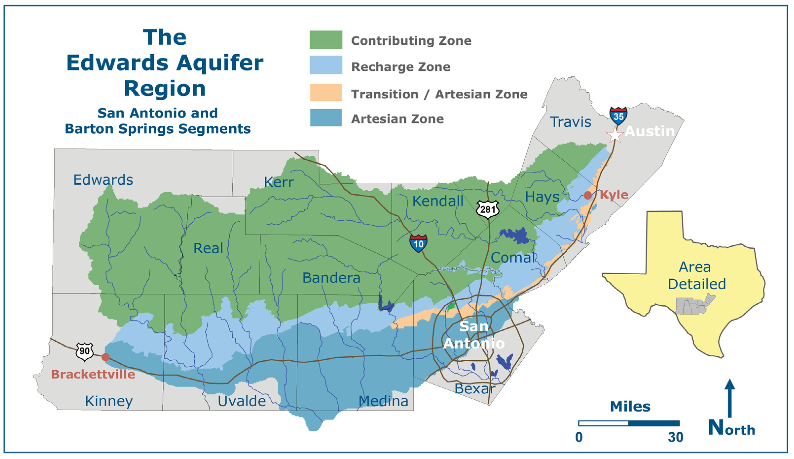
The Edwards (Balcones Fault Zone) Aquifer (Figure 1) is a complexly faulted karst groundwater formation stretching across South-Central Texas from Brackettville, Texas, east to San Antonio, Texas, northeast through Austin, Texas, and then northwest of Austin, Texas [3,4,5]. It consists of three segments: the northern segment, the Barton Springs segment, and the San Antonio segment, hereinafter referred to as the Edwards Aquifer. The Edwards Aquifer (San Antonio segment) is one of the most permeable and productive carbonate aquifers in the United States and encompasses a drainage (contributing) zone of approximately 4400 square miles (11,396 km2), a recharge zone of 1500 square miles (3885 km2), and an artesian (confined) zone of 2100 square miles (5439 km2), totaling approximately 8000 square miles (20,720 km2) [6,7]. The Edwards Aquifer has a high transmissivity resulting from the highly permeable and porous nature of the Edwards limestone, which contains numerous interconnected joints, fractures, caves, and solution channels [8].
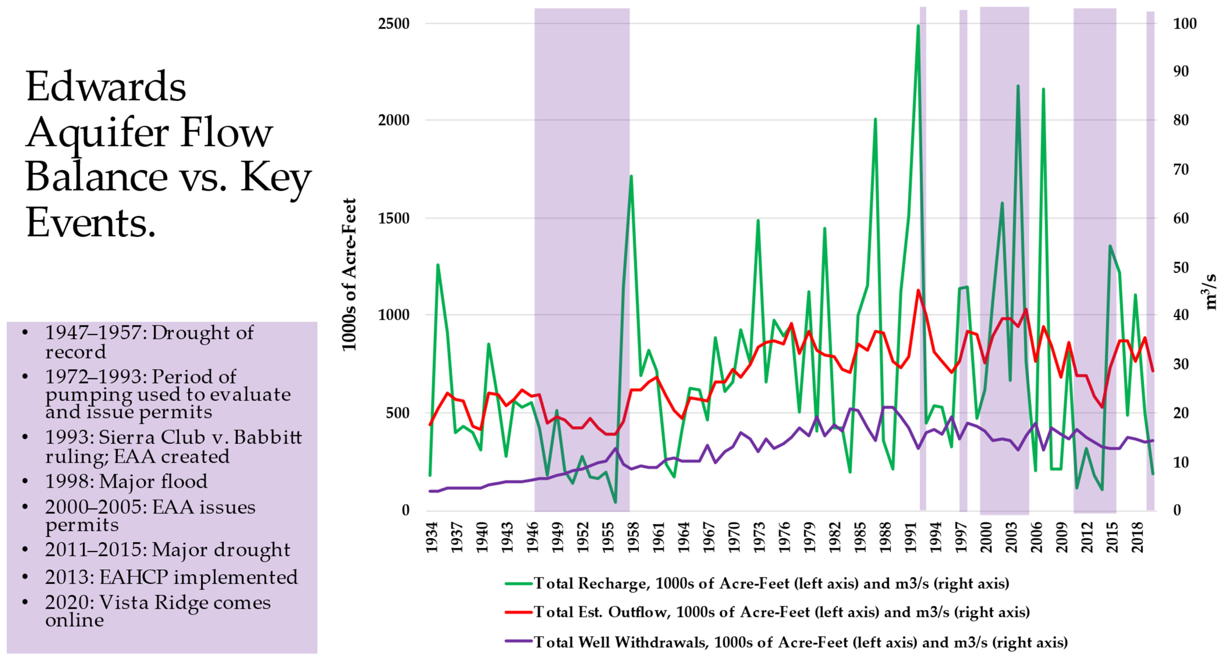
Comal and San Marcos Springs are among the largest springs in the United States [9]. Comal Springs consists of at least 18 springs outlets [10]) and San Marcos Springs consists of over 200 outlets originating from large fissures and copious small openings underneath Spring Lake [10]. San Antonio, Comal, and San Marcos Springs are also the sources of the San Antonio, Comal, and San Marcos rivers, all of which are tributaries to the Guadalupe River [11]. Waters discharging from Comal and San Marcos Springs provide substantial base flow for the Guadalupe River and contribute a substantial but variable portion of the surface water available downstream in the Guadalupe River. Combined, Comal and San Marcos Springs contributed an annual average of 338,500 acre-feet (ac-ft) (4.2 × 10⁷ cubic meters [m3]) of water into the Guadalupe River from 1957 to 2020 (Table 1). During droughts, the discharge from both springs diminishes in total volume, but the discharge increases in terms of the springs’ overall contribution to instream flows in the Guadalupe River and freshwater inflows for San Antonio Bay and the Guadalupe Estuary. During the region’s frequent droughts, the springs regularly provide the majority of flow in the river and inflow to the bay and estuary [12]. Edwards Aquifer groundwater supports the economies of San Antonio, the agriculture-based counties west of San Antonio, the eastern spring counties of Comal and Hays, and the counties downstream of the springs within the Guadalupe River Basin including the Gulf Coast. The State of Texas has issued permits for surface water rights within the Guadalupe River Basin that are based in part on the discharge from Comal and San Marcos Springs. Much of the surface water permitted by the State of Texas for the Guadalupe River is contained in permits issued prior to 1956 when aquifer withdrawals were less than 320,000 ac-ft/year (3.9 × 10⁷ m3) (Figure 2). Edwards Aquifer withdrawals grew from an estimated 100,000 ac-ft (1.2 × 10⁷ m3) in 1934 to a peak of 542,400 ac-ft (6.7 × 10⁷ m3) during the drought year of 1989 (Table 1). The possibility that Comal and San Marcos Springs could become intermittent or cease to flow grew as withdrawals from the Edwards Aquifer increased [13].
The level of the Edwards Aquifer depends on annual rainfall and aquifer recharge (which are highly variable), and discharge from the springs and groundwater withdrawals (which are less variable). Average annual rainfall across the region varies from 23.4 inches (594 mm [mm]) in Uvalde, Texas—in Uvalde County, a key western recharge area—to 32.9 inches (836 mm) in San Antonio and 35.7 inches (907 mm) in San Marcos to the east [16]. Much of the Edwards Aquifer’s recharge occurs as the result of brief but intense storms that fall in watersheds of mostly perennial overlying streams in the Nueces, San Antonio, and Guadalupe rivers, which cross the aquifer recharge zone [17]. The majority of the recharge enters the aquifer west of San Antonio as runoff from storms that cross the Nueces River Basin, which flows south across the recharge zone, where water comes into direct contact with the outcrop of the porous Edwards limestone [8]. Because the Edwards Aquifer is primarily recharged west of San Antonio and large amounts of the water reemerges east of San Antonio at Comal and San Marcos Springs, the aquifer can be thought of as an massive natural trans-basin diversion from the Nueces River Basin to the Guadalupe River Basin [18]. As the water flows eastward within the confined or artesian zone, wells intercept a significant portion of the aquifer’s annual recharge [8]. Regions such as the Edwards Aquifer region that depend on the discharge from karst aquifers, particularly those that provide the majority of the region’s water supply, are uniquely vulnerable to droughts because they can experience extraordinary declines in water levels even from short droughts [19].
Major multiyear droughts affecting South-Central Texas have occurred once or twice a century for the last 500 years [20]. In Texas, the critical drought period used for planning and management purposes is called the drought of record, generally referring to the worst drought that has occurred in a region since detailed records have been kept (1895 in Texas [21]). For Texas, the drought of record occurred from 1950 to 1957 [13,19]. Zero flow was recorded at Comal Springs for 144 days in 1956, and the Bexar County groundwater index well for the Edwards Aquifer, J-17, declined to a record low of 612.5 feet (186 m) above mean sea level on 17 August 1956 [13,22]. For the Edwards Aquifer region, the drought of record began as early as 1942, with below-average recharge that continued until 1957. The annual average recharge for 1942–1956 was 300,600 ac-ft (3.7 × 10⁷ m3), less than half of the annual recharge for the period of record, 1934–2020, which was 700,000 ac-ft (8.6 × 10⁷ m3) [13]. During the drought of record, industries that depended on Comal and San Marcos Springs discharge continued to operate only through implementing emergency measures [23]. Regional tree-ring chronologies reveal that between 1500 and 2000 droughts similar to or more severe than the drought of record have occurred on average every 100 years or fewer [20]. While the drought of record is the event Texas water supply strategies are designed to withstand, droughts worse than the drought of record have been identified in the past, and similar droughts lurk somewhere over the horizon [20].
1.2. Groundwater and Surface Water Regulation in Texas
Historically, there was no limit to groundwater withdrawals from the Edwards Aquifer [24]. Beginning in 1904, groundwater use in Texas was guided solely by the English common law concept known as “the rule of capture,” the right of capture, the law of absolute ownership, and other names [25]. Under the rule of capture, groundwater can be withdrawn by an owner of the overlying land without any meaningful restriction. Groundwater can even be withdrawn from beneath an adjoining owners’ land, unless a state statute prevents such use [24]. In addition, under the rule of capture, remedies in tort law are unavailable to an adjoining landowner whose groundwater is adversely impacted by someone else’s pumping except in the unlikely case that waste can be proven [24]. In contrast, surface water in Texas is governed by the appropriative water rights doctrine, also known as prior appropriation, which is common in most of the western United States [24]. Under this doctrine, surface water is held in trust by the state for the benefit of all the people, subject to a state-granted right to use the water [24]. Those who are “first in time” are “first in right” to take or divert water from a surface watercourse or reservoir and apply it to a beneficial use [24]. During a water shortage, those with senior rights may call on the State of Texas through the Texas Commission on Environmental Quality (TCEQ) to restrict or eliminate use by junior water right holders.
As coexisting legal frameworks, prior appropriation and the rule of capture ignore the fundamental hydrologic connection between surface and groundwater and have encouraged incompatible behaviors by water users, depending on the source, by treating surface and groundwater as separate legal entities. This legal and hydrological dichotomy was an acute complicating factor for those responsible for managing water in the Edwards Aquifer and the Nueces, San Antonio, and Guadalupe Rivers because of the high degree of interconnection between the rivers and the aquifer. Prior to the creation of the Edwards Aquifer Authority (EAA) in 1993, the differences in Texas surface and water law meant that water in the Edwards Aquifer region went on a legal journey as well as a hydrologic journey [26]. As surface water, primarily from the Nueces River Basin, entered the aquifer recharge zone, it left the appropriative water rights jurisdiction of the State of Texas via TCEQ (and predecessor agencies) and became groundwater. Its use was then guided solely by the rule of capture, and therefore pumping was unregulated. When the groundwater was discharged from Comal and San Marcos Springs, it again became surface water subject to the jurisdiction of the State of Texas. Until the creation of the EAA, the water travelled through regulated, unregulated, and then back to regulated jurisdictions.
1.3. Ecology
While the water needs of the growing population of South-Central Texas were once the sole determinant of groundwater use, protection of the Edwards Aquifer’s unique ecosystem is now an important competing factor. Considered one of the most diverse aquifer ecosystems in the world, the Edwards Aquifer is home to species that are found nowhere else and of which little is truly known [27]. The U.S. Fish and Wildlife Service (USFWS) within the U.S. Department of the Interior considers the ecosystems of Comal and San Marcos Springs to contain one of the greatest known diversities of aquatic organisms of any ecosystem in the southwestern United States [28]. This diversity results partly from the constant water temperature and flow of the high-quality water of the Edwards Aquifer, which creates unique ecosystems that support the endemic species development [28]. Comal and San Marcos Springs are the major natural discharge points from the aquifer as well as habitat for one threatened, six endangered, and one extinct species, as well as three species that the USFWS has deemed warranted for listing under the ESA (Table 2) [29,30]. The USFWS recovery priority for these species indicates that each faces a high degree of threat and a low potential for recovery, and that the survival of each species is in conflict with various human activities [28]. When determining whether a species should be protected under the ESA, the USFWS or National Marine Fisheries Service (NMFS) may find that listing a species is “warranted but precluded.” This means that USFWS or NMFS has determined that a species should be listed based on the best available science, but that the listing of other species takes priority because there is a greater need for their protection [31].
During dry periods, when withdrawals from the Edwards Aquifer increase, and the flow from the springs diminishes to critical levels, the aquatic habitats of the species in Table 2 are impacted, causing “takes” of these species that are listed under the ESA [33]. “Take” means “to harass, harm, pursue, hunt, shoot, wound, kill, trap, capture, or collect, or to attempt to engage in any such conduct” and may affect as few as one individual of the species [33]. At the same time, the diminishing spring discharge reduces the flow of surface water downstream in the Guadalupe River, diminishing the availability of state-issued surface water rights. Extremely low flow or no flow from these springs places the species in “jeopardy” which is not defined in the ESA. The take of a threatened or endangered species by any person—including private citizens, agencies, and any other individuals or groups—who is subject to the jurisdiction of the United States constitutes a violation of the ESA [33]. Otherwise lawful activities, such as withdrawals from the aquifer for municipal, industrial, agricultural, and other uses contribute to the reduction of spring discharge at Comal and San Marcos Springs, which in turn can cause takes of the listed species [34]. In addition, the springs contribute to instream flows that benefit a variety of species within the Guadalupe River, and the river ultimately provides freshwater inflows to San Antonio Bay, which is the winter home of the majority of iconic endangered whooping cranes (Grus americana) [35].
1.4. Sierra Club et al. v. Babbitt et al.: Pumping Limits Mandated
The landmark legal case concerning the Edwards Aquifer has been Sierra Club et al. v. Babbitt et al. (Sierra Club v. Babbitt) [11]. In 1991, the Sierra Club filed the ESA lawsuit in the U.S. District Court in Midland, Texas, alleging that the Secretary of the Interior and the USFWS had allowed takings of endangered species by not ensuring a water level in the aquifer sufficient to maintain the flow of Comal and San Marcos Springs to provide aquatic habitat for the endangered species it had listed [34]. The Sierra Club’s motivation was to protect the threatened and endangered species and their associated habitats [34]. The Guadalupe-Blanco River Authority (GBRA) had initiated the original threat to sue under the ESA [36]. The GBRA general manager who approved the litigation, John Specht, stated that the GBRA’s motivation in Sierra Club v. Babbitt was to protect the water resources of the Guadalupe River Basin, including surface water rights issued by the State of Texas and held by GBRA. Specht believed action had to be taken before the occurrence of another drought similar to the drought of record [36].
The Sierra Club, which was now joined by the GBRA and other parties, requested that the primary defendant (USFWS) be required to restrict withdrawals from the Edwards Aquifer under certain conditions and develop and implement recovery plans for the listed endangered and threatened species in the aquifer and Comal and San Marcos Springs [34]. On 1 February 1993, Senior U.S. District Court Judge Bunton ruled in favor of the plaintiffs and required the USFWS to determine the minimum spring discharge requirements to avoid take and jeopardy of the listed species in both springs [34]. The court ruled that if the Texas Legislature did not adopt a management plan to limit withdrawals from the Edwards Aquifer by the end of its then-current session, the plaintiffs could return to the court and request additional relief [34]. (Note that Texas Legislature meets only in odd numbered years from beginning of January until end of May, unless the governor convenes a special session of the legislature.) The court’s grim warning prompted the Texas Legislature to address the aquifer dispute:
“The next session of the Texas Legislature offers the last chance for adoption of an adequate state plan before the ‘blunt axes’ of Federal intervention have to be dropped.”
1.5. EAA
1.5.1. The Texas Legislature Creates the EAA
Senate Bill 1477, or the Edwards Aquifer Authority Act (EAA Act), was adopted by the Texas Legislature on 30 May 1993, one day prior to the court’s deadline [26]. The newly minted EAA Act created a conservation and reclamation district, named the EAA, which replaced a preexisting district with very limited powers, the Edwards Underground Water District. The EAA was charged with regulating groundwater withdrawals pursuant to the Conservation Amendment in the Texas Constitution, Article XVI, Section 59, by creating a permit system based on the historic use of groundwater for five counties and portions of three other counties, on top of the rule of capture [26]. Under the EAA Act, withdrawals were initially limited to 450,000 ac-ft (5.6 × 10⁷ m3) annually and, after 31 December 2007, 400,000 ac-ft (4.9 × 10⁷ m3) annually, unless drought conditions required the adoption of greater restrictions [26]. By 31 December 2012, “the authority [EAA] … shall … ensure that … the continuous minimum springflows of the Comal Springs and the San Marcos Springs are maintained to protect endangered and threatened species to the extent required by federal law.” [26]. Withdrawals for domestic and livestock use were excluded from the 450,000 ac-ft (5.6 × 10⁷ m3) and 400,000 ac-ft (4.9 × 10⁷ m3) annual limits [38]. The EAA Act guaranteed agricultural irrigators 2 ac-ft of water per acre of irrigated cropland. In addition, the EAA was also specifically charged with protecting threatened and endangered species [26]. The EAA managed the transition from a pure rule of capture system to a hybrid system of permitted groundwater withdrawals [39]. The rule of capture still applies to the Edwards Aquifer in that the use of individual groundwater permits are still not subject to remedies under tort law [39]. The EAA was originally intended to assume the responsibilities described above on 1 September 1993 [39]. However, a series of legal challenges delayed the EAA’s operation until a decision by the Texas Supreme Court affirming the constitutionality of the EAA Act on 28 June 1996 [40].
1.5.2. Pumping Limits
The EAA was authorized to achieve the required limits on withdrawals through the process of issuing permits and potentially by purchasing and retiring permitted groundwater rights when the pumping cap was reduced from 450,000 ac-ft (5.6 × 10⁷ m3) to 400,000 ac-ft (4.9 × 10⁷ m3) [26]. If the EAA eventually decided to purchase and retire groundwater rights, the downstream users in the Guadalupe River Basin were to contribute to the money needed to purchase the 50,000 ac-ft (0.6 × 10⁷ m3) reduction (Table 3) [26].
In 2000, the EAA proposed to issue 818 regular permits totaling 532,275 ac-ft (6.7 × 10⁷ m3) [41]. The agency was required to limit pumping to 450,000 acre-feet (5.6 × 10⁷ m3) per year initially and reduce pumping to 400,000 acre-feet (4.9 × 10⁷ m3) by 2008, but it was also required to issue minimum annual pumping rights to users who could prove their use during the prior 21 years. Once the process concluded, the EAA had issued permits totaling 549,000 ac-ft (6.8 × 10⁷ m3) of annual pumping from the Edwards Aquifer, which was approximately 99,000 ac-ft (1.2 × 10⁷ m3) above the initial limit specified in Senate Bill 1477. The EAA indicated that instead of reducing permitted withdrawals to 450,000 ac-ft (5.6 × 10⁷ m3) before 2008 and 400,000 ac-ft (4.9 × 10⁷ m3) after 2008, the EAA might seek to raise the authorized pumping limits to 500,000 ac-ft (6.2 × 10⁷ m3) or more annually through an amendment to the EAA Act by the Texas Legislature [42].
1.5.3. Habitat Conservation Plan
Under the ESA, the “taking” of federally listed species can be authorized by obtaining an incidental take permit (ITP) under Section 10(a) of the ESA when the taking is the inadvertent result of a legal activity [46]. This means that nonfederal parties can be shielded from ESA penalties if their otherwise legal activities result in the take of a species [46]. For the Edwards Aquifer, an ITP would allow groundwater withdrawals that could cause the take of listed species at Comal or San Marcos Springs to continue until the jeopardy spring discharge levels were reached [47]. To obtain a permit, a plan would need to be developed to implement measures to prevent the aquifer from declining below levels that would cause spring discharge to decline and, in turn, cause jeopardy or extinction for the species in Table 2.
Development of a habitat conservation plan (HCP) is required for an ITP [46]. A regional Edwards Aquifer HCP would have to address the sustainable use of the aquifer to secure a multiyear permit authorizing incidental takes by those entities and individuals who would eventually sign the application. Holders of the ITP, or permittees, would be protected from an ESA enforcement action when Comal and/or San Marcos Springs declined below critical levels [47]. During Sierra Club v. Babbitt, a draft HCP for the Edwards Aquifer was developed in 1994 and 1995 for the U.S. District Court by an appointed court monitor, Joe G. Moore, Jr; the author; and a panel of stakeholders representing regional water interests involved in the dispute [47,48]. The primary themes of the draft HCP were the conservation and reuse of existing water supplies and the introduction of additional ground and surface water to the region to reduce withdrawals from the aquifer. Before the first Edwards Aquifer HCP could be completed, the U.S. Fifth Circuit Court of Appeals ordered the district court to close Sierra Club v. Babbitt in 1996 with the publication of a new USFWS recovery plan, ending the first effort to create an Edwards Aquifer HCP.
2. The Edwards Aquifer Recovery Implementation Program Is Created
By 2007, with the 2008 deadline looming for the total permitted groundwater to be reduced to 400,000 ac-ft (4.9 × 10⁷ m3), the region faced the real possibility of an additional era of ESA litigation if the existing permits totaling 549,000 ac-ft (6.8 × 10⁷ m3) could not be reduced by a staggering 149,000 ac-ft (1.8 × 10⁷ m3). Beyond 2008, the EAA was still facing the requirement to adopt a plan to reduce pumping during droughts and implement and enforce measures by 31 December 2012, to ensure “minimum continuous spring flows” to protect the listed species to the extent required by federal law. That amount was likely to be less than 321,100 ac-ft (4.0 × 10⁷ m3), which was the amount of groundwater that was withdrawn in 1956 when zero flow was recorded at Comal Springs for 144 days. In 2003 and 2005, legislation was introduced and considered by the Texas Legislature to eliminate the future requirement for reductions in aquifer withdrawals. However, these bills were generally opposed by stakeholders representing downstream water right holders and environmental interests and were not approved. Thus, when the 2007 session of the Texas Legislature began, the withdrawal limit issue and the issue of the 31 December 2012, deadline were still unresolved. Meanwhile, the cost of purchasing a one-acre-foot groundwater right in the Edwards Aquifer had risen to as much as USD 5000/ac-ft (1233 m3) [49]. The cost of buying down permits from 549,000 ac-ft (6.8 × 10⁷ m3) to 450,000 ac-ft (5.6 × 10⁷ m3) and then retiring 50,000 ac-ft of permits to reach 400,000 ac-ft (4.9 × 10⁷ m3) was estimated to be as much as USD 725 million [49]. The downstream surface water users who were potentially responsible for half the cost of retiring permits from 450,000 ac-ft (5.6 × 10⁷ m3) to 400,000 ac-ft (4.9 × 10⁷ m3) might have been required to pay USD 125 million.
These circumstances spawned an attempt to find a way to avoid the further conflict that would likely result as the 2008 deadline approached and to protect the endangered species and downstream surface water rights. The GBRA reached out to the USFWS for assistance, and on 14 December 2005, the author met with Dale Hall, USFWS Director, in Washington, D.C. The discussion with Director Hall centered on the need to avoid another period of protracted litigation and conflict over the Edwards Aquifer, of which the USFWS would be at the center due to the USFWS’ role under the ESA. The USFWS had recently been at the center of an ESA water conflict over the use of the Klamath River that had been an incredibly difficult issue for the USFWS to manage. Director Hall offered to consult his senior staff and then contact the GBRA with a recommended course of action. On 7 January 2006, GBRA General Manager Bill West met with USFWS employee Ren Lohoefener in Phoenix, Arizona, during a National Water Resources Association Leadership Seminar. Lohoefener, with whom the author had met multiple times regarding Edwards Aquifer issues while Lohoefener was the USFWS Texas State Administrator, informed West that the USFWS recommended that Edwards Aquifer stakeholders participate in a recovery implementation program (RIP). RIPs are voluntary, multi-stakeholder initiatives under the ESA that are developed by the USFWS that seek to balance water use and development with federally listed species recovery. To achieve this balance, the stakeholders develop a comprehensive document that outlines the program goals, activities, timelines, measurements of success, and roles of the participants and execute an agreement to implement the activities outlined in the program document.
Thus, with the 2008 deadline to reduce the permitted withdrawals looming and water costing thousands of dollars per acre-foot, the Texas Legislature was called on in 2007 to resolve the problem by compelling the Edwards Aquifer stakeholders to enter into an RIP. This presented an opportunity for the Texas Legislature to avoid becoming embroiled in another fight over the aquifer while compelling the aquifer stakeholders to create their own final compromise on the aquifer’s management that would also satisfy the USFWS. In the meantime, in the months prior to the 2007 legislative session, the USFWS would attempt to encourage the Edwards Aquifer stakeholders to voluntarily initiate their own RIP.
At this time, the author and West met with Texas Representative Patrick Rose, whose district included the city of San Marcos and San Marcos Springs. Representative Rose was briefed on the status of the pending issues regarding the Edwards Aquifer, and the GBRA representatives requested that Representative Rose ask the State to analyze the potential impacts to Comal and San Marcos Springs of a repeat of the drought of record under the existing EAA management plan. Representative Rose agreed with the need for stakeholders and the Texas Legislature to know the potential impacts to the aquifer ahead of the 2007 legislative session, and the author prepared a request for modeling, which Representative Rose sent to the Texas Water Development Board (TWDB) and TCEQ [50]. TWDB released the requested modeling on 12 February 2007. The modeling projected that Comal Springs would cease to flow for up to 30 months during a repeat of the drought of record conditions under the EAA’s current pumping and critical period management rules, as opposed to less than five months (144 days) as had actually occurred in 1956 during the drought of record [51]. In addition, springflows at Comal Springs were predicted to be a monthly average of below 30 cubic feet per second (cfs) (0.8 m3/s) for 54 months [51]. At San Marcos Springs, in the simulation of a repeat of the drought of record, the springs were not as sensitive to the different pumping scenarios during a repeat of the drought of record, but springflow was below the 100 cfs (2.8 m3/s) jeopardy level the entire time for the same 30-month period during the drought of record [51]. These stunning results immediately galvanized concerns about the potential extirpation of the listed species at Comal and San Marcos Springs, the drastic impacts on downstream water rights, the impacts on communities that depended on the river, and the potential impact on the ecology of San Antonio Bay that could result from a steep reduction in freshwater inflows from the Guadalupe River Basin. These sobering results would frame and shape the coming debate and action at the Texas Legislature and throughout the stakeholder process that followed for the next five years.
It is with this renewed attention to the issues surrounding the Edwards Aquifer’s future that the USFWS brought together regional stakeholders in late 2006 to participate in an RIP to develop a plan to contribute to the recovery of federally listed species dependent on the Edwards Aquifer. The voluntary effort to initiate an RIP formally began on 16 February 2007 [49]. Several additional meetings were held with stakeholders over the next few months, but this effort never gained any momentum, likely because many stakeholders were simultaneously focused on creating a more structured process through the Texas Legislature.
Therefore, the author, representing the GBRA, along with other principal stakeholders worked with the 80th Texas Legislature when it convened on 9 January 2007, and until it adjourned on 28 May 2007, to find a legislative solution to the Edwards Aquifer dispute. The Texas Legislature responded to the stakeholders’ willingness to pursue a negotiated end to the aquifer dispute and passed Senate Bill 3, which (1) raised the aquifer pumping cap to 572,000 ac-ft (7.1 × 10⁷ m3) to avoid the immediate crisis of cutting pumping rights to 400,000 ac-ft (4.9 × 10⁷ m3); (2) adjusted the critical period management requirements established by the EAA in its regulations; and (3) directed the EAA and certain other state and municipal water agencies to participate in the Edwards Aquifer Recovery Implementation Program (EARIP) and prepare a plan by the 2012 deadline for managing the aquifer that would be sufficient to preserve the endangered species at Comal and San Marcos Springs and receive approval by the USFWS [52]. The Texas Legislature directed that the plan must include recommendations regarding withdrawal adjustments during critical periods that would ensure “minimum continuous spring flows” throughout a repeat of the drought of record to protect federally listed species associated with the Edwards Aquifer [52]. Senate Bill 3 directed the EAA to “cooperatively develop a recovery implementation program” through a facilitated, consensus-based process that involved input from the USFWS, other appropriate federal agencies, and all interested stakeholders, including specified state agencies [52]. The stakeholders in the EARIP would include state agencies, local water resource authorities, water purveyors, environmental groups, municipalities, public utilities, and other individuals and groups interested in the aquifer and the species residing in the aquifer. Although Senate Bill 3 directed the “EAA and the other stakeholders” to provide money to finance the activities of the EARIP, the legislation did not provide any funding for them to do so [52].
The EARIP differed from other USFWS RIPs in several ways. Typically, RIPs involve a federal interest such as federal land, a federal agency (or agencies) managing water through the operation of a federal dam, or both federal land and a federal agency. The federal agency then typically contributes a significant portion of the funding to conduct the RIP process and to implement the solution. However, the EARIP did not involve federal land or a federal agency because the land above the Edwards Aquifer is not federal land and the aquifer is not managed by a federal agency.
Another key difference between the EARIP and other RIPs was the Texas Legislature’s involvement. Participation in the EARIP was not voluntary for some of the stakeholders because Senate Bill 3 required the EAA and certain other state and municipal water agencies to participate in the process [52]. Moreover, development of the program document in a typical RIP can take many years because the ESA does not establish a limit on how many years the process can require. The Texas Legislature, however, limited that time to less than five years [52]. The Texas Legislature also established certain specific tasks and deadlines for accomplishing these tasks.
2.1. The EARIP Forges the Edwards Aquifer HCP
Senate Bill 3 called for the creation of a steering committee by 30 September 2007, to oversee and assist in the development of the EARIP [52]. The EARIP Steering Committee included 26 members representing environmental, water authority, water purveyor, industrial, municipal, public utility, state agency, and agricultural interests related to the Edwards Aquifer. Twenty-one of the member organizations of the EARIP Steering Committee were established in Senate Bill 3. (Note that the author was the Steering Committee member representing one of the two primary historical antagonists, the Guadalupe-Blanco River Authority.) The remaining five members were added by the Steering Committee to ensure that a broad diversity of interests was represented during the process. In early 2008, approximately 40 stakeholder groups or individuals executed a memorandum of agreement with the USFWS setting out how the EARIP process would be conducted.
A program manager, Dr. Robert Gulley, was hired to facilitate EARIP meetings and eventually transitioned into the role of mediator of the process once it was clear to the stakeholders that a mediator was needed. Gulley had been a litigator at the U.S. Department of Justice focusing on endangered species litigation, and after earning the trust of the stakeholders, he was deemed the best choice to mediate the remaining issues. Depending on what was on the agenda, between 40 and 100 people routinely attended the monthly meetings of the EARIP and its Steering Committee, which were held at several locations across the Edwards Aquifer region so local residents could better attend some meetings. The meetings were also attended by Texas legislators and their staff, the USFWS, and members of the media. Between the monthly meetings of the Steering Committee, the EARIP used small work groups and committees of stakeholders to examine and provide recommendations regarding specific issues. The use of these breakout groups was effective in facilitating the resolution of complex or contentious issues during the decision-making process. As a result, some stakeholders attended EARIP meetings almost every week during the process. A list of the various committees and work groups used by the EARIP are set out in Section 1.7.1 of the Edwards Aquifer Habitat Conservation Plan (EAHCP) [53]. The most prominent of these committees was the Science Subcommittee, a committee of scientific experts with expertise in the ecology and hydrology of the Edwards Aquifer appointed by the Steering Committee. The Science Subcommittee was required to submit the initial recommendations on a range of issues identified in Senate Bill 3 to the Steering Committee and to the stakeholders by 31 December 2008.
2.2. Funding the Implementation of the EAHCP
The issue of how to fund the EAHCP’s implementation was the most contentious issue that the EARIP had to resolve. The annual cost of implementing the EAHCP was estimated for the first seven years to average over USD 18.6 million annually. Early in 2008, the author and a delegation of stakeholders attended a meeting in Washington, D.C., with the USFWS. The USFWS indicated that if the stakeholders were successful and an HCP was approved by the USFWS, substantial funding from Congress to implement the EAHCP might be possible. However, subsequent meetings dashed any hopes of obtaining significant federal funding in the aftermath of the global recession. This was a critical reversal because of the high estimated costs of implementing the EAHCP measures. In the absence of federal funding, aquifer management fees (AMFs), which are collected by the EAA, were a possible alternative for funding the EAHCP. However, the use of AMFs was not the preferred choice of the EARIP for two major reasons. First, there was a feeling among many stakeholders that because the EAHCP was being developed in part to satisfy the federal ESA, the federal government should provide a significant financial contribution. Second, irrigators—who were the second largest group of aquifer pumpers behind municipal pumpers—would not share in the costs if AMFs were used because AMFs for irrigation use are limited to USD 2/ac-ft (1233 m3) by the EAA Act. Removing this limitation would require an act of the Texas Legislature, which at the time heavily favored agricultural interests [26]. Seeking an alternative financing mechanism to finance the EAHCP, the stakeholders turned once again to the Texas Legislature. As the 2011 legislative session began, bills were introduced in the Texas House of Representatives (House Bill 2760) and Senate (Senate Bill 1595) on behalf of the EARIP stakeholders that would have allowed voters in the Edwards Aquifer region to decide whether to pay for the EAHCP through revenues from a sales tax. However, neither of these bills emerged from the committees to which they were assigned. Once the sales tax option was eliminated, serious discussions began regarding the use of AMFs and contributions from the downstream interests to pay for the EAHCP. However, as the summer of 2011 began, numerous discussions among the stakeholders had not overcome the impasse over the funding issue.
At this point, EARIP Program Manager Robert Gulley met with the leaders of the two primary antagonists in the Edwards Aquifer dispute, the San Antonio Water System (SAWS), the single largest user of aquifer water, and the GBRA, the single largest holder of senior consumptive downstream water rights below Comal and San Marcos Springs. The goal of the meeting was for Gulley to mediate a solution to the final key impediment blocking the approval of EAHCP and the resolution of the multi-decade dispute: how the USD 18.6 million per year would be funded. After frank discussions, an agreement was reached by which SAWS would pay the vast majority of the costs through increases in AMFs, which they would pay to the EAA. As the single largest user of Edwards Aquifer groundwater, SAWS provides approximately 85% of the funding that goes to the EAA via AMFs, which the EAA distributes to implement the various elements of the EAHCP. The GBRA would contribute USD 400,000 per year and seek additional contributions from other downstream surface water right holders. Dow Chemical, another major downstream surface water right holder who benefits from the increased springflow from the springs, along with other contributors, brings the annual contribution toward funding the EAHCP implementation costs to USD 736,000. GBRA and SAWS would both increase their rates to customers by similar percentages so that their ratepayers would cover these costs, although the vastly larger population served by SAWS would provide close to USD 15 million annually.
2.3. The Stakeholders, the EAA, and the USFWS Approve EAHCP
On 7 November 2011, the Steering Committee met in Seguin, Texas in the GBRA River Annex. After much debate and compromise, the final and most important task mandated by the Texas Legislature was completed as the Steering Committee voted to approve the final package of agreements consisting of the EAHCP, a joint funding agreement, a joint management agreement, and an implementing agreement, which had been negotiated over the previous five years. The final vote was twenty-four to approve, one to reject, and one abstention. The one stakeholder who objected took issue not with the habitat conservation plan but with the method of paying for its implementation. This vote marked a huge step forward for the region that had long seemed unattainable.
On 13 December 2011, at its regularly scheduled monthly meeting, the EAA Board of Directors voted to approve the EAHCP and implementing agreement but tabled a decision on the related Funding and Management Agreement (FMA) by a vote of eight to seven because of a disagreement over the impact of the FMA on the year-end rebate of aquifer pumping fees (fees that were paid at the beginning of the year) to pumpers who had pumped less than what was estimated at the beginning of the year. However, on 28 December 2011, at a special called meeting, the EAA Board of Directors approved the FMA by a vote of fifteen to zero. The EAHCP and supporting documents were then submitted to the Texas Legislature and for approval to the USFWS along with the ITP application on 5 January 2012. On an anticlimactic note, the Federal Register published the USFWS record of the decision approving the issuance of the ITP and the EAHCP on 15 February 2013, missing the deadline established in 1993 by the EAA Act by only 45 days [54]. One month later, on 15 March 2013, the EAHCP went into effect, hailing the end of the 57-year dispute over the management of the Edwards Aquifer.
2.4. The Key Components of the EAHCP
The EAHCP covers a term of 15 years with the potential to renew the ITP in 2028. The implementation of the EAHCP is divided into two phases. In the first phase, habitat protection measures to increase the viability of the species were implemented immediately at Comal and San Marcos Springs beginning in 2013. These measures included habitat restoration, the removal of invasive plants and replacement with native vegetation favored by the listed species, the maintenance of dissolved oxygen through the removal of decaying aquatic vegetation during low flows, excess sediment removal, predator control, invasive fish removal, and parasite control.
The minimization of the impacts of recreation at low flows began with the creation of scientific study areas by the Texas Parks and Wildlife Department [55]. Access to sensitive habitat, such as areas of Texas wild-rice, is now limited during low-flow periods such as droughts. Water quality measures are now in place that include an incentive program for low impact development, best management practices, a local ban on the use coal tar sealants, and expanded water quality monitoring.
The first phase also focused on implementing actions to ensure continuous minimum springflow during a repeat of the drought of record. These flow protection measures included the Voluntary Irrigation Suspension Program Option (VISPO), which pays irrigators to suspend their use of groundwater during severe droughts, a regional municipal conservation program, the use of SAWS’ aquifer storage and recovery (ASR) H2Oaks facility to store water to offset pumping during severe drought, and additional emergency groundwater pumping restrictions during critical periods that can reduce withdrawals of individual permit holders by 44% during Stage V [53].
These measures were evaluated through a comprehensive monitoring program, and adjustments have occasionally been made through a robust adaptive management process, namely an agreement amendment process which is defined by the USFWS as “a method for examining alternative strategies for meeting measurable biological goals and objectives, and then, if necessary, adjusting future conservation management actions according to what is learned” [56]. The adaptive management process includes an applied research program to test the assumptions underlying the biological goals and objectives. The research focuses on the biological effects of low flows on species and habitat, as well as the impact of pulses of water during low-flow periods. The EAHCP also established long-term biological goals and objectives for each of the threatened and endangered species.
The ITP holders include the City of San Marcos, the City of New Braunfels, the EAA, Texas State University, and the City of San Antonio through SAWS. The rules for how these permittees manage and implement the EAHCP are set out in the FMA. The FMA established the procedures and mutual commitments among the permittees for the funding and management of the EAHCP and the adaptive management process. The FMA was executed only by the five permittees. In addition to the EAHCP and FMA, the permittees entered into an implementing agreement with the USFWS. The implementing agreement delineates the “obligations, benefits, rights, authorities, liabilities, and privileges of all signatories” to the EAHCP [57]. The implementation of the EAHCP is overseen and managed by an Implementing Committee consisting of the five ITP holders. The EAA has the primary responsibility of managing the day-to-day activities related to the EAHCP and of managing the flow protection measures except for the SAWS H2Oaks ASR facility. The cities of San Marcos and New Braunfels and Texas State University have the primary responsibility of implementing the habitat measures within their respective jurisdictional boundaries.
2.5. Ensuring That the EAHCP Can Accomplish Its Goals
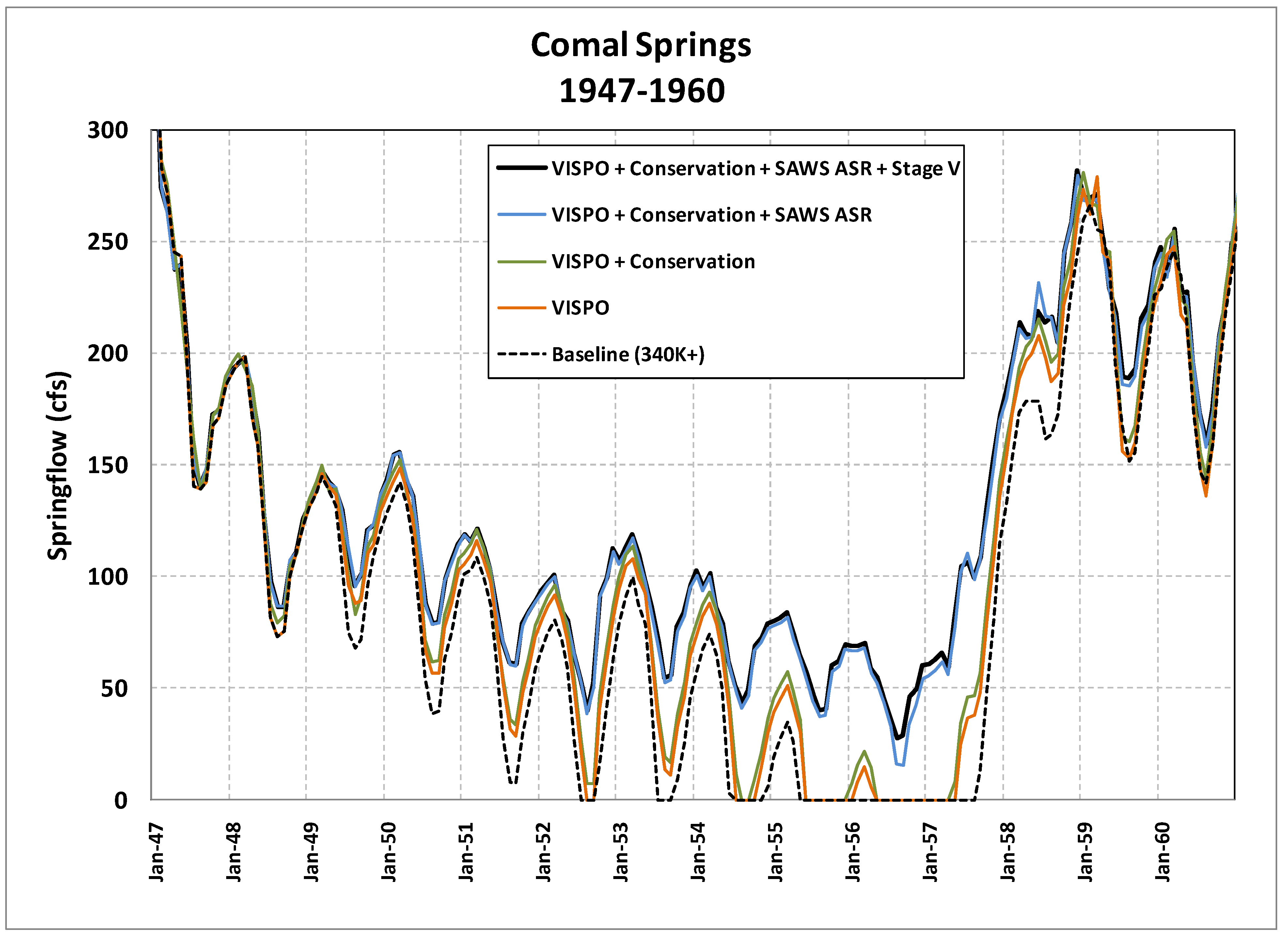
As stated earlier, under the current baseline conditions, modeling by TWDB predicted that Comal Springs would cease to flow for up to 30 months during a repeat of drought of record conditions as opposed to less than five months (144 days) as occurred in 1956 during the actual drought of record. Additional modeling by the EARIP increased the projected zero flow period to 38 months based on the full use of the higher limit for pumping of 572,000 ac-ft (6.8 × 10⁷ m3) that was authorized under Senate Bill 3 in 2007 [53]. The simulated effects of the flow-protection measures on springflow have been modeled over the historical record, including a repeat of the drought of record, to assess whether they are capable of ensuring continuous minimum springflows. In contrast, with the implementation of the EAHCP measures in place, Comal and San Marcos Springs are predicted to have continuous springflow during a repeat of the drought of record, ensuring minimum continuous springflow. Figure 3 shows a simulation of a repeat of the drought of record that compares the effects of the 572,000 ac-ft (7.1 × 10⁷ m3) pumping cap with the HCP measures. The ecological modeling of the impact of lower springflows found that these springflows will not appreciably reduce the likelihood of survival and recovery of the species covered in the EAHCP, even if a repeat of the drought of record conditions was to occur during that time, as long as all recommended measures are implemented to restore and protect the habitat of the covered species [58]. The reduction of springflows initially would seem to be a substantially negative impact to the covered species and downstream surface water rights; however, when all measures are considered, the modeling indicates that Comal Springs would flow at a monthly average of 45 cfs (1.3 m3/s), whereas during the drought of record in 1956, zero flow was recorded for 144 days. This is enormously beneficial for the covered species and for the downstream water rights, the reliability of which had been substantially constrained by the 144-day historical period. This demonstrates that the EAHCP provides a substantial benefit to the covered species. The tradeoff is that the minimum springflows necessary to protect the covered species were reduced considerably based on the research, data, and ecological modeling that were reviewed by the Science Subcommittee and ultimately accepted by the USWFS. The minimum springflow objective is now a monthly average of 45 cfs (1.3 m3/s) at Comal Springs, whereas before it was a daily flow of 200 cfs (5.7 m3/s) to avoid take of certain species and a daily flow of 150 cfs (4.2 m3/s) and under certain circumstances 60 cfs (1.7 m3/s) to avoid placing the covered species in jeopardy of extinction. For San Marcos Springs, the objective is a monthly average of 52 cfs (1.5 m3/s), whereas before it was 100 cfs to avoid jeopardy to covered species [53].
In addition, without the EAHCP measures, springflows at Comal Springs were predicted to be below a monthly average of 30 cfs (0.8 m3/s) for 54 months (Figure 3). At San Marcos Springs, in the simulation of a repeat of the drought of record, the minimum flow was projected to be 2 cfs (0.06 m3/s), and springflows will be below a monthly average of 52 cfs (1.8 m3/s) for 20 months [53]. In contrast, with the implementation of the Phase I springflow protection measures, Comal Springs is predicted to have continuous springflow during a repeat of the drought of record conditions. The minimum springflow projected at Comal Springs for Phase I was a monthly average of 27 cfs (0.7 m3/s), and springflow is projected to fall below 30 cfs on a monthly average for only 2 months over a simulated repeat of the drought of record. At San Marcos Springs, the simulated minimum monthly springflow for the Phase I is 50.5 cfs (1.4 m3/s). Springflow falls below the flow objective of 52 cfs only twice during a simulated repeat of the drought of record.
2.6. The Status of the EAHCP after 10 Years
The EAHCP is in its 11th year of implementation. Phase 1 is complete, and Phase 2 is underway. Preparations are underway to renew the ITP in 2028. To provide an independent review of the EAHCP and its measures the National Academy of Sciences, Engineering, and Medicine’s National Research Council was contracted to provide a formal review of the EAHCP body to “provide resolution of major scientific issues” [59]. The National Research Council has published three reports regarding the EAHCP with the final report published in 2018. Overall, the findings of the National Research Council were favorable while including some suggestions on improving data collection, pollution prevention measures, and the covered species protection programs [59]. Habitat restoration goals at Comal and San Marcos Springs are being met, and the expansion of the aquatic refugia at the San Marcos Aquatic Resources Center is complete [59]. The EAHCP has also survived a critical first test, the 2010–2015 drought, which was the most severe multiyear drought since the drought of record. The 2010–2015 drought triggered Stage V (the maximum) pumping reductions of 44% in Uvalde County on 28 March 2013, which went into effect only 15 days after the EAHCP [60]. The restrictions ended in 2015, and in 2020, the EAHCP reached the required 126,000 ac-ft (1.6 × 10⁷ m3) goal of water stored in the SAWS’ H2Oaks ASR facility [59]. Finally, the events that led up to the EARIP and the creation of the EAHCP are now being reevaluated. During drought conditions in 2022, Robert Puente, the President and CEO of the San Antonio Water System wrote in a commentary that reflected on Judge Bunton’s ruling in 1993, “What seemed to be a drastic move to regulate the Edwards Aquifer turned out to be a fortuitous moment in our city’s history, prepping us for a more thoughtful, sustainable approach to water management.” [61].
3. Discussion
How Did the Stakeholders Reach a Consensus on the Future of the Edwards Aquifer?
In Senate Bill 3, the Texas Legislature directed that the EARIP develop its plan through a facilitated, consensus-based stakeholder process. By requiring the various interests in the Edwards Aquifer dispute to negotiate directly, the Texas Legislature encouraged the creation of an enduring solution that directly addressed the stakeholders’ elements of disagreement and fostered the development of mutually acceptable compromises. The hard deadlines in Senate Bill 3 for achieving various milestones and reaching a final agreement focused the stakeholders to work diligently through difficult issues. The Steering Committee in its operating rules defined consensus as the absence of opposition to a decision [53]. Although the rules provided for consensus decision-making by a supermajority of 75% of the Steering Committee members when opposition occurred, in practice the decisions were mostly made without any dissent and without the need for a formal vote by Steering Committee members. This success is attributable in part to the EARIP’s open and transparent process. For each EARIP meeting, a public agenda was published a week in advance. Every meeting was open so that the public could attend and participate. Most importantly, stakeholders were given ample opportunity to discuss and debate each significant issue. Because the process was open and transparent, the stakeholders were able to develop relationships and then trust in each other. Delays and interruptions in the multiyear process that might have resulted from stakeholder turnover were avoided by requiring each stakeholder to recruit an alternate who attended and participated in the meetings.
The EARIP avoided the use of formal, rigid meeting structures and settings in which representatives sit around a table behind nameplates or before a large audience of stakeholders. Such rigid structures reinforce the differences between stakeholders, limit the flexibility of stakeholders to move away from their hardened positions to create solutions, and discourage the development of relationships that lead to trust. The informal meeting structure, plus the creation of multiple opportunities outside of the meetings, allowed stakeholders to step away from their roles and identify common interests and values, which were necessary to the process of building trust and relationships among the opposing factions.
Another key factor was that early in the process, the stakeholders agreed that no decision would be final until every issue had finally been resolved. This allowed the stakeholders to reach important interim milestone decisions without fear that they would be bound by an interim decision if subsequent issues were not resolved in a manner that they could support. In addition, the deadlines imposed by Senate Bill 3 kept the stakeholders focused on the issues and were crucial to maintaining momentum in the process. Frequently, when the stakeholders found themselves at an impasse, they shifted their focus to other less controversial issues and returned later to the unresolved issue.
Early in the multiyear process a team of facilitators was brought into the process to help the stakeholders move through some of the more difficult issues. The results were disappointing, however the experience helped the stakeholders to recognize that what was really needed was a mediator. Robert Gulley, the program manager, having gained the confidence of the stakeholders expanded his role to become the de facto mediator. The EARIP also brought numerous stakeholders into the process of resolving the Edwards Aquifer dispute, which allowed progress to be achieved by expanding the issues under consideration and thereby enlarging the set of potential solutions. It is also important to note that many stakeholders had been working on issues related to the Edwards Aquifer for decades prior to the EARIP. These stakeholders understood that the EARIP offered the last realistic chance for a regional decision rather than one imposed by a federal court, the Texas Legislature, or the USFWS. Furthermore, the final stages of the decision-making process in 2011 coincided with the driest year since record-keeping began in Texas in the late 1800s. The exceptional drought conditions reinforced that federal litigation through the ESA was the likely alternative if the stakeholders failed. The threat of renewed ESA litigation if the EARIP was unsuccessful and the ongoing drought that raged during the key EARIP decision year of 2011 served as external forcing mechanisms that kept stakeholders engaged through the most difficult portions of the process in an effort to avoid the negative consequences. However, there was also real concern among the stakeholders to avoid being blamed for the failure of the five-year process, which had been followed closely by the public through the news media, during the devastating drought.
Finally, on multiple occasions the EARIP was on the brink of collapsing because of an impasse over an important element of the EAHCP. At each of those points, the stakeholders would remind each other of how much progress they had achieved during the preceding years. As a result, a compromise was always found. The first such instance involved the author’s reluctance to accept the interim decision supporting dramatically lower spring discharge rates for Comal and San Marcos Springs. Because this interim decision did not require me to support the final plan I was willing to continue participating in the process to determine if other elements of the plan would ultimately address my concerns, and they did.
4. Conclusions
In response to Judge Bunton’s ruling in Sierra Club v. Babbitt, the EAA was created by the Texas Legislature to settle disputes by quantifying rights through groundwater permits, thus restricting aquifer pumping during droughts, and to develop a plan to preserve threatened and endangered species associated with Comal and San Marcos Springs. Although the EAA accomplished the first two goals, it needed the help of the Texas Legislature and regional aquifer stakeholders to ultimately develop a sufficient and durable plan to accomplish the third goal. This development resulted in the EARIP, which created the crucial support among the major stakeholders that led to the creation of the EAHCP. The EAHCP has successfully resolved issues that the former regulatory framework was unable to address. After 10 years, the resulting peace is still in place and the EAA, ITP holders, and stakeholders continue to successfully implement the regional consensus on how to manage the Edwards Aquifer to protect the federally listed species in the spring systems.
The EAHCP demonstrates what can be achieved by stakeholders committed to the difficult labor necessary to create an agreement that they all can accept. There are many other seemingly intractable water disputes beyond the borders of the Lone Star State that could benefit from a process similar to the one that resulted in the landmark agreement for the Edwards Aquifer.
Funding
This research received no external funding.
Data Availability Statement
Data supporting this article may be accessed through the following websites: https://www.edwardsaquifer.org/ (accessed on 14 February 2022), https://www.edwardsaquifer.net/index.html (accessed on 14 February 2022), and https://www.usgs.gov/centers/oklahoma-texas-water-science-center/science/edwards-aquifer-studies-texas (accessed on 14 February 2022).
Acknowledgments
I wish to thank Guest Editor Brian Richter for the opportunity to contribute to this special issue of Water. I also wish to thank Gregg Eckhardt and Chantal Cough-Schulze for their reviews and comments, which improved this article.
Conflicts of Interest
The author was directly involved in many of the events described in this article.
Abbreviations
| Short Name or Acronym | Descriptive Name |
| ac-ft | acre-feet |
| AMF | aquifer management fees |
| ASR | aquifer storage and recovery |
| cfs | cubic feet per second |
| EAA | Edwards Aquifer Authority |
| EAHCP | Edwards Aquifer Habitat Conservation Plan |
| EARIP | Edwards Aquifer Recovery Implementation Plan |
| ESA | Endangered Species Act |
| FMA | Funding and Management Agreement |
| GBRA | Guadalupe-Blanco River Authority |
| HCP | habitat conservation plan |
| ITP | Incidental Take Permit |
| km | kilometers |
| m3/s | cubic meters per second |
| m | Meters |
| m/s | Meters per second |
| NWS | National Weather Service |
| RIP | recovery implementation plan |
| SAWS | San Antonio Water System |
| TCEQ | Texas Commission on Environmental Quality |
| TNRIS | Texas Natural Resource Information System |
| TPWD | Texas Parks and Wildlife Department |
| TWDB | Texas Water Development Board |
| USFWS | United States Fish and Wildlife Service |
| VISPO | voluntary irrigation suspension program option |
References
- U.S.C. Title 42—The Public Health and Welfare, Subchapter XII—Safety of Public Water Systems. §§ 300f–300j. Available online: https://www.govinfo.gov/content/pkg/USCODE-1994-title42/html/USCODE-1994-title42-chap6-subchapXII.htm (accessed on 13 April 2022).
- Thuss, M.; San Antonio Water Systems, San Antonio, TX, USA. Personal communication, 1999.
- The Edwards Aquifer Website. Available online: http://www.edwardsaquifer.net/ (accessed on 13 April 2022).
- Edwards Aquifer Authority. Available online: https://www.edwardsaquifer.org/ (accessed on 26 October 2022).
- Oklahoma-Texas Water Science Center—Science. Available online: https://www.usgs.gov/centers/oklahoma-texas-water-science-center/science (accessed on 3 November 2022).
- Edwards Aquifer Authority. The Edwards Aquifer: A Texas Treasure, 2; Edwards Aquifer Authority: San Antonio, TX, USA, Undated.
- Ozuna, G. U.S. Geological Survey Memorandum 1; U.S. Geological Survey: San Antonio, TX, USA, 1997. [Google Scholar]
- Klemt, W.B.; Knowles, T.R.; Elder, G.R.; Sieh, T.W. Ground-Water Resources and Model Applications for the Edwards (Balcones Fault Zone) Aquifer in the San Antonio Region; Texas Department of Water Resources: Austin, TX, USA, 1979; pp. 23, 36. Available online: https://www.edwardsaquifer.org/wp-content/uploads/2019/02/1979_Klemt-etal_Resources-and-Model.pdf (accessed on 1 April 2022).
- Brune, G. Major and Historical Springs of Texas; Texas Water Development Board: Austin, TX, USA, 1975; pp. 39, 45. Available online: https://www.twdb.texas.gov/publications/reports/numbered_reports/doc/R189/R189.pdf (accessed on 1 April 2022).
- Brune, G. Springs of Texas; Texas A&M University Press: College Station, TX, USA, 1981; pp. 131, 223. [Google Scholar]
- Votteler, T.H. The little fish that roared: The Endangered Species Act, state groundwater law, and private rights collide over the Texas Edwards Aquifer. Envtl. L 1998, 28, 845, 847–848. [Google Scholar] [CrossRef]
- Votteler, T.H. Raiders of the lost aquifer? Or, the beginning of the end to fifty years of conflict over the Texas Edwards Aquifer. Tulane Environ. Law J. 2002, 15, 262. [Google Scholar]
- Votteler, T.H. Water from a Stone: The Limits of the Sustainable Development of the Texas Edwards Aquifer. Ph.D Thesis, Southwest Texas State University, San Marcos, TX, USA, 23 February 2000. [Google Scholar]
- Slattery, R.; Thomas, D.E. Recharge to and Discharge from the Edwards Aquifer in the San Antonio Area, Texas, 2000; U.S. Geological Survey: San Antonio, TX, USA, 2001; pp. 2–4. Available online: https://tx.usgs.gov/reports/dist/dist-2001-01/images/Edwards00FS.pdf (accessed on 1 April 2022).
- Numeric Data for Charts and Graphs—The Edwards Aquifer Website. Available online: https://www.edwardsaquifer.net/data.html (accessed on 13 April 2022).
- U.S. Climate Data. Available online: https://www.usclimatedata.com (accessed on 24 February 2022).
- Todd Engineers. Edwards Aquifer Optimization Overview 9; Todd Engineers: Alameda, CA, USA, 1999. [Google Scholar]
- Nevola, R. Regulation of the Edwards Aquifer-Conjunctive Management of Surface Water and Groundwater. In Proceedings of the Texas Water Conservation Association Mid-Year Technical Conference, Waco, TX, USA, 1989; pp. 11–12. [Google Scholar]
- Texas Water Development Board. Water for Texas: A Consensus-Based Update to the State Water Plan; Texas Water Development Board: Austin, TX, USA, 1997; pp. 2–36. Available online: https://www.twdb.texas.gov/waterplanning/swp/1997/index.asp (accessed on 1 April 2022).
- Cleaveland, M.K.; Votteler, T.H.; Stahle, D.K.; Casteel, R.C.; Banner, J.L. Extended chronology of drought in South Central, Southeastern, and West Texas. Tex. Water J. 2011, 2, 54–96. [Google Scholar] [CrossRef]
- National Climatic Data Center–Climate Diagnostics Center, 2011. Data Archive. Available online: http://www1.ncdc.noaa.gov/pub/data/cirs (accessed on 13 April 2022).
- Longley, G. The Relationship Between Long Term Climate Change and Edwards Aquifer Levels, with an Emphasis on Droughts and Spring Flows. In Proceedings of the Water for Texas Conference, Austin, TX, USA, 26–27 January 1995; Available online: https://www.edwardsaquifer.org/wp-content/uploads/2019/02/1995_Longley_ClimateChangeEdwardsAquifer.pdf (accessed on 1 April 2022).
- Lowry, R.L. A Study of Droughts in Texas; Texas Board of Water Engineers: Austin, TX, USA, 1959; p. 34. Available online: https://www.twdb.texas.gov/publications/reports/bulletins/doc/B5914/B5914.pdf (accessed on 1 April 2022).
- Kaiser, R.L. Handbook of Texas Water Law: Problems and Needs; Texas Water Resources Institute: College Station, TX, USA, 1987; pp. 18–20, 22, 32. [Google Scholar]
- Houston Texas Central Railroad Company v. W.A. East. Available online: https://casetext.com/case/h-tc-ry-co-v-east (accessed on 15 December 2021).
- Chapter 626, S.B. No. 1477–73rd Legislature—Regular Session. §§ 1.14(a)–(h), 1.16, 1.22(a), 1.29(d)–(e). Available online: https://lrl.texas.gov/scanned/sessionLaws/73-0/SB_1477_CH_626.pdf (accessed on 15 December 2021).
- Longley, G. The Edwards Aquifer: Earth’s most diverse groundwater ecosystem? Int. J. Speleol. 1981, 11, 12. [Google Scholar] [CrossRef]
- The San Marcos/Comal Recovery Team and U.S. Fish and Wildlife Service. San Marcos and Comal Springs and Associated Aquatic Ecosystems (Revised) Recovery Plan; U.S. Fish and Wildlife Service: Austin, TX, USA, 1996; pp. 6, 27–28. Available online: https://www.edwardsaquifer.org/wp-content/uploads/2019/02/1996_FWS_SanMarcosComalRevisedPlan.pdf (accessed on 1 April 2022).
- 74 FR 66865—Endangered and Threatened Wildlife and Plants; Partial 90-Day Finding on a Petition to List 475 Species in the Southwestern United States as Threatened or Endangered with Critical Habitat. Available online: https://www.govinfo.gov/app/details/FR-2009-12-16/E9-29699 (accessed on 15 December 2021).
- 86 FR 54298—Endangered and Threatened Wildlife and Plants; Removal of 23 Extinct Species From the Lists of Endangered and Threatened Wildlife and Plants. Available online: https://www.govinfo.gov/app/details/FR-2021-09-30/2021-21219 (accessed on 15 December 2021).
- Alexander, K. Warranted but Precluded: What That Means Under the Endangered Species Act (ESA); Congressional Research Service: Washington, DC, USA, 2010; Available online: https://esadocs.defenders-cci.org/ESAdocs/misc/CRS_Warranted_but_precluded.pdf (accessed on 1 April 2022).
- 45 FR 47355—Endangered and Threatened Wildlife and Plants; Listing of the San Marcos Salamander as Threatened, the San Marcos Gambusia as Endangered, and the Listing of Critical Habitat for Texas Wild Rice, San Marcos Salamander, San Marcos Gambusia, and Fountain Darter. Available online: https://www.govinfo.gov/app/details/FR-1980-07-14 (accessed on 15 December 2021).
- U.S. Code: Title 16—Conservation-§ 1532. Available online: https://www.govinfo.gov/content/pkg/USCODE-2021-title16/pdf/USCODE-2021-title16-chap35-sec1532.pdf (accessed on 15 December 2021).
- Sierra Club v. Lujan. 1 February 1993. Case Was Filed Initially as Sierra Club v. Lujan; Subsequent Proceedings Are Now Referred to as Sierra Club v. Babbitt, Reflecting Changes in U.S. Department of Interior Secretaries from Manuel Lujan to Bruce Babbitt. Available online: https://casetext.com/case/sierra-club-v-lujan-2 (accessed on 22 November 2022).
- 43 FR 20938–Determination of Critical Habitat for the Whooping Crane. Available online: https://www.govinfo.gov/app/details/FR-1978-05-15 (accessed on 15 December 2021).
- Specht, J.; Guadalupe-Blanco River Authority, Seguin, TX, USA. Personal communication, 1999.
- Finding 196, Amended Findings of Fact and Conclusions of Law, Sierra Club v. Lujan. 26 May 1993. Available online: https://casetext.com/rule/utah-court-rules/utah-rules-of-civil-procedure/part-vi-trials/rule-52-findings-and-conclusions-by-the-court-amended-findings-waiver-of-findings-and-conclusions-correction-of-the-record-judgment-on-partial-findings (accessed on 22 November 2022).
- SB 1477, 73rd R.S. Available online: https://lrl.texas.gov/legis/billsearch/BillDetails.cfm?legSession=73-0&billtypeDetail=SB&billNumberDetail=1477 (accessed on 3 March 2022).
- Amicus Edwards Authority Brief on the Merits; Sipriano v. Great Spring Waters of America, Inc.: Hazleton, PA, USA, 1999; Available online: https://www.lexisnexis.com/community/casebrief/p/casebrief-sipriano-v-great-spring-waters-of-am-inc (accessed on 22 November 2022).
- Barshop, v. Medina County Underground Water Conservation District. Available online: https://casetext.com/case/barshop-v-medina-cty-underground-water-cnsrvtn (accessed on 3 March 2022).
- Edwards Aquifer Authority. Edwards Aquifer Authority Technical Media Briefing on Proposed Groundwater Permits; Edwards Aquifer Authority: San Antonio, TX, USA, 2000; pp. 2, 4. [Google Scholar]
- Ellis, G. Edwards Aquifer Authority General Manager Remarks. In Proceedings of the Meeting of South Central Texas Regional Water Planning Group, San Antonio, TX, USA, 7 February 2002. [Google Scholar]
- U.S. Geological Survey. Letter Report from U.S. Geological Survey to Edwards Aquifer Authority; U.S. Geological Survey: San Antonio, TX, USA, 10 April 2020; Statistics compiled and calculated by author. [Google Scholar]
- Edwards Aquifer Authority. Fact Sheet Final Groundwater Permit Amounts Established; Edwards Aquifer Authority: San Antonio, TX, USA, 2005. [Google Scholar]
- Edwards Aquifer Authority. Report to the Edwards Aquifer Legislative Oversight Committee; Texas Legislature: Austin, TX, USA, 5 October 2006. [Google Scholar]
- U.S. Code: Title 16—Conservation-§ 1539. Available online: https://www.govinfo.gov/content/pkg/USCODE-2011-title16/pdf/USCODE-2011-title16-chap35-sec1539.pdf (accessed on 15 December 2021).
- Moore, J.G.; U.S. District Court, Midland, TX, USA; Votteler, T.H.; U.S. District Court, Midland, TX, USA. Draft Habitat Conservation Plan for the Edwards Aquifer (Balcones Fault Zone—San Antonio Region). Unpublished Draft Report. 1995. [Google Scholar]
- Sierra Club v. Babbitt, No. MO 91 CA 069, Slip Opinion. 30 September 1994. Available online: https://casetext.com/case/sierra-club-v-babbitt-5 (accessed on 22 November 2022).
- Gulley, R.L. Heads Above Water: The Inside Story of the Edwards Aquifer Recovery Implementation Program; Texas A&M University Press: College Station, TX, USA, 2015. [Google Scholar]
- Rose, P.M.; Texas House of Representatives, San Marcos, TX, USA. Letter from Texas Representative Patrick Rose to Texas Commission on Environmental Quality Executive Director Glenn Shankle and Texas Water Development Board Administrator Kevin Ward. Unpublished Letter. 22 November 2006. [Google Scholar]
- Mace, R.E.; Donnelly, A.C.A.; Wade, S. GAM Run 06-33a; Texas Water Development Board: Austin, TX, USA, 2007; pp. 1, 14, 16. Available online: https://www.twdb.texas.gov/groundwater/docs/GAMruns/GR06-33.pdf (accessed on 1 April 2022).
- Chapter 1430, S.B. No. 3—80th Legislature—Regular Session. §§ 1.26A(a), 1.26A(d)(1), 1.26A(d)(3), 1.26A(e), 1.29(i). Available online: https://lrl.texas.gov/scanned/sessionLaws/80-0/SB_3_CH_1430.pdf (accessed on 1 April 2022).
- RECON Environmental, Inc.; Hicks & Company; Zara Environmental LLC; BIOWEST. Edwards Aquifer Recovery Implementation Program Habitat Conservation Plan; Edwards Aquifer Recovery Implementation Program: San Antonio, TX, USA, 2019; pp. 1–20, 4–52, 5–9, 5–45, 5–54. Available online: https://www.edwardsaquifer.net/pdf/Final_HCP.pdf (accessed on 1 April 2022).
- 78 FR 11218-Final Environmental Impact Statement and Record of Decision on the Edwards Aquifer Recovery Implementation Program Habitat Conservation Plan for Incidental Take of 11 Species (8 Federally Listed) in 8 Texas Counties. Available online: https://www.govinfo.gov/app/details/FR-2013-02-15/2013-03431 (accessed on 15 December 2021).
- Parks and Wildlife Code—Title 5. Wildlife and Plant Conservation. § 81.501. Available online: https://statutes.capitol.texas.gov/Docs/PW/htm/PW.81.htm (accessed on 1 April 2022).
- 65 FR 35241-Notice of Availability of a Final Addendum to the Handbook for Habitat Conservation Planning and Incidental Take Permitting Process. Available online: https://www.govinfo.gov/app/details/FR-2000-06-01/00-13553 (accessed on 15 December 2021).
- U.S. Fish and Wildlife Service. Habitat Conservation Planning and Incidental Take Permit Processing Handbook; U.S. Fish and Wildlife Service: Washington, DC, USA, 1996; pp. 3–37. Available online: https://www.edwardsaquifer.org/wp-content/uploads/2019/02/1996_FWS_HCP-ITPP-Handbook.pdf (accessed on 1 April 2022).
- Hardy, T.B.; Kollaus, K.; Tower, K. Evaluation of the Proposed Edwards Aquifer Recovery Implementation Program/Drought of Record Minimum Flow Regimes in the Comal and San Marcos River Systems; Texas State University River Systems Institute: San Marcos, TX, USA, 2010; Available online: https://www.edwardsaquifer.org/doc_publications/evaluation-of-the-proposed-edwards-aquifer-recovery-implementation-program-drought-of-record-minimum-flow-regimes-in-the-comal-and-san-marcos-river-systems/ (accessed on 1 April 2022).
- Edwards Aquifer Habitat Conservation Plan. A Decade of Delivering; EAHCP Steward: San Antonio, TX, USA, 2022; Available online: https://www.edwardsaquifer.org/wp-content/uploads/2022/03/2022-2-EAHCP-Steward-A-Decade-of-Delivering.pdf (accessed on 1 April 2022).
- Edwards Aquifer Authority. Edwards Aquifer Authority Declares Stage V for Uvalde County: J-27 Monitoring Well Below 840 Feet; Edwards Aquifer Authority: San Antonio, TX, USA, 2013. [Google Scholar]
- Puente, R. As Drought Deepens, SAWS Has Plenty of Water. Here’s Why. San Antonio Express-News. 3 August 2022. Available online: https://www.expressnews.com/opinion/commentary/article/Puente-drought-SAWS-17348475.php (accessed on 5 August 2022).
Figure 1.
The Edwards Aquifer. Gregg Eckhardt, 2023.

Figure 2.
Edwards Aquifer flow balance vs. key events. Gabriel Collins 2023.

Figure 3.
Comal Springs simulated springflow during a repeat of the drought of record under with the EAHCP measures implemented using the GWSIM-IV model [8]. The GWSIM-IV model was a widely accepted model that was developed in 1979 and was accepted without objection by the stakeholders.
Figure 3.
Comal Springs simulated springflow during a repeat of the drought of record under with the EAHCP measures implemented using the GWSIM-IV model [8]. The GWSIM-IV model was a widely accepted model that was developed in 1979 and was accepted without objection by the stakeholders.


Table 1.
Hydrologic characteristics of the Edwards Aquifer [14,15]. Author calculated 1934–2020 figures using data from [14,15].
| One Acre-Foot (ac-ft) | 325,851 Gallons of Water (1233 m3) |
|---|---|
| Average annual recharge (1934–2020) | 700,000 ac-ft (8.6 × 10⁷ m3) |
| Median annual recharge (1934–2020) | 556,100 ac-ft (6.9 × 10⁷ m3) |
| Record lowest recharge (1956) | 43,700 ac-ft (0.5 × 10⁷ m3) |
| Record highest recharge (1992) | 2,486,000 ac-ft (30.7 × 10⁷ m3) |
| Average annual discharge of Comal Springs to the Guadalupe River (1928–2020) | 208,300 ac-ft (2.6 × 10⁷ m3) |
| Average annual discharge of San Marcos Springs to the Guadalupe River (1957–2020) | 127,800 ac-ft (1.6 × 10⁷ m3) |
| Average annual discharge of both Comal and San Marcos Springs to the Guadalupe River during the overlapping data range (1957–2020) | 338,500 ac-ft (4.2 × 10⁷ m3) |
| Species | Year Listed | Current Status | Present in Comal Springs Ecosystem | Present in San Marcos Springs Ecosystem | Habitats |
|---|---|---|---|---|---|
| Fountain Darter (Estheostoma fonticola) | 1973 | Endangered | Yes | Yes | Springs and rivers |
| Comal Springs Dryopid Beetle (Stygoparnus comalensis) | 1997 | Endangered | Yes | No | Springs |
| Peck’s Cave Amphipod Stygobromus pecki) | 1997 | Endangered | Yes | No | Springs |
| Comal Springs Riffle Beetle (Heterelmis comalensis) | 1997 | Endangered | Yes | Yes | Springs |
| San Marcos Salamander (Eurycea nana) | 1980 | Threatened | No | Yes | Springs |
| San Marcos Gambusia (Gambusia georgei) | 1980 | Extinct | No | Last record 1980 | Springs and river |
| Texas Blind Salamander (Typhlomolge rathbuni) | 1967 | Endangered | No | Yes | Subterranean |
| Texas Wild-Rice (Zizania texana) | 1978 | Endangered | No | Yes | River |
| Edwards Aquifer Diving Beetle (Haideoporus texanus) | 2009 | Listing may be warranted | Yes | Yes | Subterranean |
| Texas Troglobitic Water Slater (Lirceolus smithii) | 2009 | Listing may be warranted | Yes | Yes | Subterranean |
| Comal Springs Salamander (Eurycea sp.) | 2009 | Listing may be warranted | Yes | No | Subterranean |
| Regulatory Requirement, Record, or Event | Water Volume |
|---|---|
| Total groundwater withdrawals in 1956 during the drought of record when Comal Springs ceased to flow | 321,100 ac-ft (4.0 × 10⁷ m3) |
| Record high groundwater withdrawals (1989) | 542,400 ac-ft (6.7 × 10⁷ m3) |
| Total amount of groundwater withdrawals requested in 1084 permit applications | 846,180 ac-ft (10.4 × 10⁷ m3) |
| Total groundwater withdrawals originally allowed under Senate Bill 1477 before 2008 | 450,000 ac-ft (5.6 × 10⁷ m3) |
| Total groundwater withdrawals originally allowed under Senate Bill 1477 beginning in 2008 | 400,000 ac-ft (4.9 × 10⁷ m3) |
| Amount the Texas Water Development Board’s model and the U.S. Fish and Wildlife Service indicated could be pumped during a repeat of the drought of record without causing jeopardy at Comal and San Marcos Springs | 175,000 ac-ft (2.6 × 10⁷ m3) |
| Breakdown of the total groundwater permits initially authorized by the Edwards Aquifer Authority in 2005 | 549,000 ac-ft (6.8 × 10⁷ m3) total 253,400 ac-ft (3.1 × 10⁷ m3) irrigated agricultural 253,400 ac-ft (3.1 × 10⁷ m3) municipal 42,100 ac-ft (0.5 × 10⁷ m3) industrial |
| Total amount of permitted groundwater ultimately authorized by the Texas Legislature in 2007 | 572,000 ac-ft (7.1 × 10⁷ m3) |
| Total groundwater withdrawals in 2020 | 362,400 ac-ft (4.8 × 10⁷ m3) |
Disclaimer/Publisher’s Note: The statements, opinions and data contained in all publications are solely those of the individual author(s) and contributor(s) and not of MDPI and/or the editor(s). MDPI and/or the editor(s) disclaim responsibility for any injury to people or property resulting from any ideas, methods, instructions or products referred to in the content. |
© 2023 by the author. Licensee MDPI, Basel, Switzerland. This article is an open access article distributed under the terms and conditions of the Creative Commons Attribution (CC BY) license (https://creativecommons.org/licenses/by/4.0/).
Share and Cite
MDPI and ACS Style
Votteler, T.H. Hands across the Water: How the 57-Year Dispute over the Edwards Aquifer Began, Persisted, and Was Resolved. Water 2023, 15, 1835. https://doi.org/10.3390/w15101835
AMA Style
Votteler TH. Hands across the Water: How the 57-Year Dispute over the Edwards Aquifer Began, Persisted, and Was Resolved. Water. 2023; 15(10):1835. https://doi.org/10.3390/w15101835
Chicago/Turabian StyleVotteler, Todd H. 2023. "Hands across the Water: How the 57-Year Dispute over the Edwards Aquifer Began, Persisted, and Was Resolved" Water 15, no. 10: 1835. https://doi.org/10.3390/w15101835
Note that from the first issue of 2016, this journal uses article numbers instead of page numbers. See further details here.