
A Review of Hydrological Studies in the United Arab Emirates


1
School of Energy, Geosciences, Infrastructure, and Society, Heriot-Watt University, Dubai Campus, Dubai P.O. Box 38103, United Arab Emirates
2
School of Energy, Geoscience, Infrastructure and Society (EGIS), Heriot-Watt University, Edinburgh EH14 4AS, UK
*
Author to whom correspondence should be addressed.
Water 2023, 15(10), 1850; https://doi.org/10.3390/w15101850
Submission received: 31 March 2023
/
Revised: 4 May 2023
/
Accepted: 11 May 2023
/
Published: 12 May 2023
(This article belongs to the Section Hydrology)
Abstract
:The increasing interest in hydrological studies in the United Arab Emirates (UAE) has resulted in the publication of several papers on hydrology and its broad use for addressing contemporaneous challenges confronting humans and the environment in the region. However, for several reasons, these efforts have remained invisible and unrecognized. This paper has reviewed the literature on hydrological research in the UAE to provide a comprehensive source of information for researchers, practitioners, policymakers, and other stakeholders. The documented studies were carefully selected, relying on a bibliometric analysis methodology of five phases to specify the boundary of the study area, adopt the primary keywords for the search, evaluate the obtained papers, exclude the non-conforming ones, and classify the final results into four distinguished topics—namely, rainfall analysis, urban growth and flood hazards, cloud seeding and changing climate, and groundwater situation and utilization. The evaluation process considered assessing the papers’ relevancy, authenticity, and coverage of the main issues of interest. In all, a total of 50 published papers were identified based on the specified criteria and reviewed. The main findings were first that the amount of rainfall over the UAE has been declining in the last decade, and this trend is expected to continue, although intensities are rising, suggesting shorter duration events. Secondly, the extensive urban growth in the country has resulted in increasing incidences of urban floods and declining groundwater recharge. Both of these are to be expected as consequences of the increased imperviousness from urbanization and the higher intensities from shorter-duration rainfall events. Thirdly, although the cloud-seeding program has proved to be successful in increasing precipitation amounts, the impact of this on flooding due to more extreme rainfall intensities and on air quality remains worrisome. Finally, groundwater analyses have shown that it is still the main freshwater resource in the country, but its long-term sustainability and quality are being threatened by the declining recharge. This calls for a national policy for groundwater management in the UAE to tackle the challenges associated with the increasing demand for water in all sectors of the economy. The study recommended addressing the gap in the hydrological literature of the UAE, specifically in the field of big meteorological data analysis, the socioeconomic impacts of urban floods, the impacts of climate change in urbanized regions, and the possibility of using alternative resources to recharge groundwater as part of sustainable water management.
1. Introduction
In the United Arab Emirates, scientific research in hydrology has rapidly developed over the last decade to understand several urban and environmental phenomena related to the movement, distribution, quality, and quantity of water. The increasing demand for natural water resources reflects part of the challenges associated with urban growth in this arid or semi-arid part of the world. Issues of recurring urban floods, deterioration in the effectiveness of storm drainage networks, shortage or inadequacy of comprehensive hydro-meteorological data, and the natural challenges of the terrain and soil composition related to water resources can be effectively tackled through sound hydrological research. In response to these needs, issues such as rainfall analysis, urban flood impacts, cloud-seeding effects, and groundwater budget caught the attention of a large number of researchers in the country and encouraged them to explore possible solutions to these matters.
Despite the actual and immediate need to investigate hydrological opportunities and challenges in the UAE, especially those accompanied by socioeconomic and environmental impacts, researchers’ efforts are being hindered by a lack of data and/or official restrictions on their availability. The essential data required, such as historical meteorological data, GIS maps, and the details of the existing stormwater drainage networks, are typically kept from researchers and students under the pretext of unconvincing excuses. Therefore, the data-exchange policy in the UAE needs to be reassessed to allow for data seekers to obtain the required information within a legal governance framework.
The advances in artificial intelligence techniques provided an alternative source of obtaining and processing hydrological data in several ways, such as predictive modeling, image recognition, and remote-sensing data analysis. The contributions by Adeloye and Rustum [1] and Mwale et al. [2] in implementing the Kohonen Self-Organizing Map to infill and reconstruct meteorological data represent an essential reference for tackling similar issues in the UAE and the region.
In addition, the cooperation with networks of hydrology centers such as the Global Network of Water Quality Monitoring (GNWQM) and the Global Hydrology Resource Center (GHRC) provides substantial opportunities for local hydrologists to integrate data and share experiences that contribute to supporting the research efforts in the UAE. The efforts of the National Center of Meteorology in utilizing the capabilities of the latest technical instruments and encouraging the exchange of experiences with the scientific staff at the center have further contributed to the ease of availability of important meteorological data for researchers. The center manages 108 ground meteorological stations covering large areas of the UAE and monitoring data throughout the year.
This paper aims to review the hydrological literature on the UAE, thus creating a comprehensive reference study for researchers and other stakeholders. This broad aim was achieved by the following specific objectives:
- Assembling all papers published related to hydrology in the UAE;
- Exploring the initiatives and contributions of related organizations in the country in these research efforts;
- Categorizing the published papers into groups based on their aims and objectives;
- Presenting the main results of these papers.
Description of the Study Area
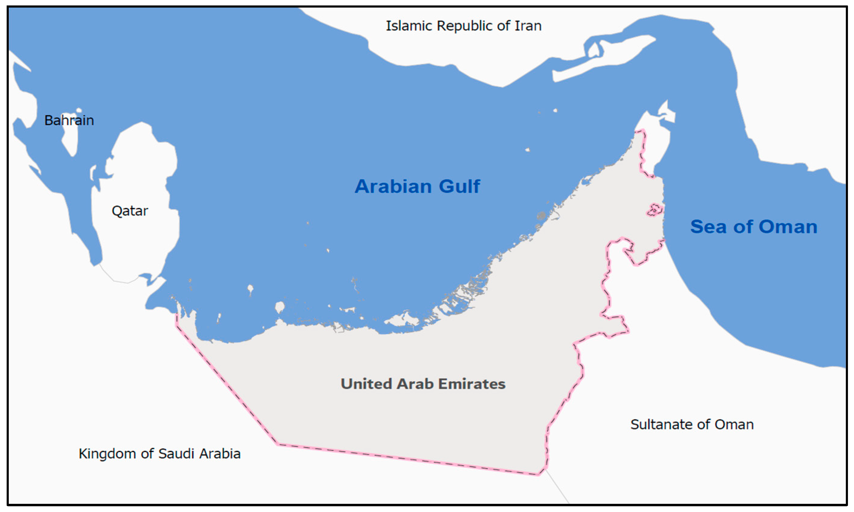
The UAE is located in the Arabian Peninsula between Oman in the east, Saudi Arabia in the south and west, and Arabian Gulf in the north. Geographically, it is located between UTM coordinates 2883648 Northing 40 R and 2503242 Northing 40 Q and 559185 Easting 39 R and 437054 Easting 40 R, as shown in Figure 1 [3].
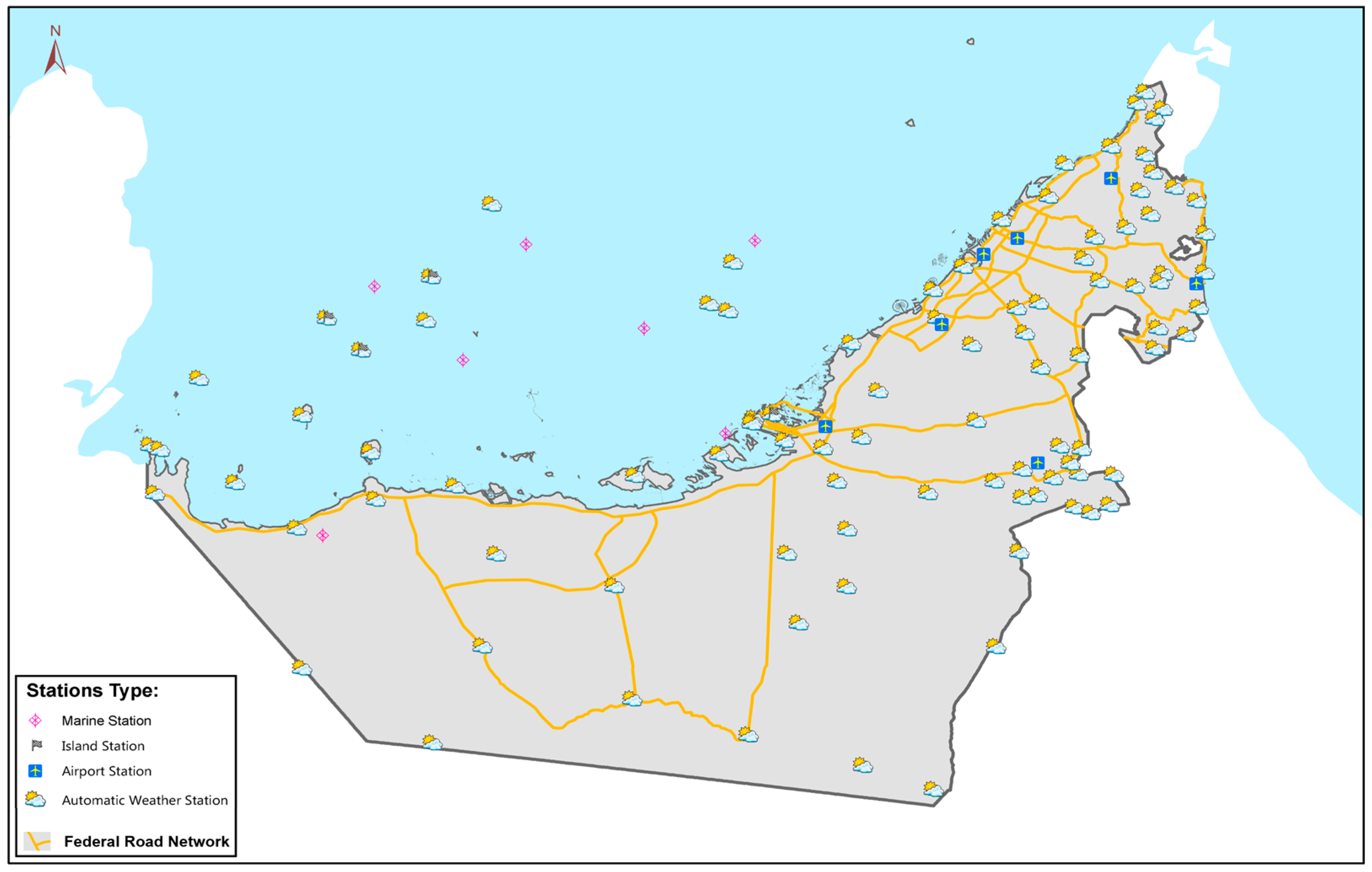
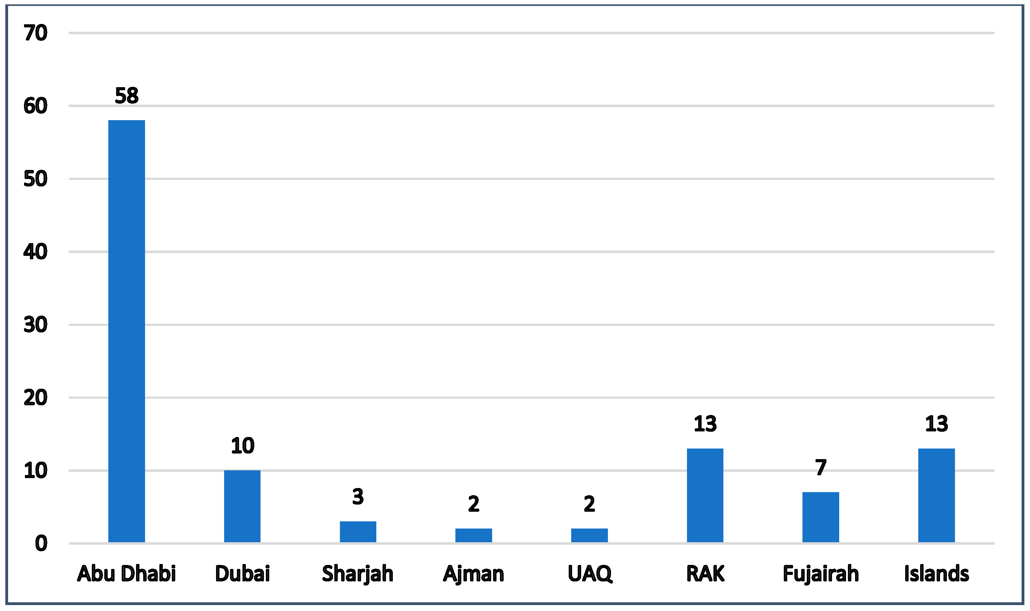
The climate in the country is arid, with an average minimum daily temperature of 14 °C in the winter season between December and February and 45 °C in the summer between June and August (Aldababseh et al. [4]. The UAE contains 108 meteorological stations spread all over the country, as shown in Figure 2 [5], with additional stations at the country’s airports. The National Centre of Meteorology is the official authority responsible for operating these stations and cooperating with the concerned authorities and researchers. The numbers of these stations and their geographical distribution are presented in Figure 3, whereas the details of these stations, including their official ID number, names, coordinates, elevations, and installation dates are attached in Appendix A. These stations monitor essential meteorological data such as rainfall records, temperature, humidity ratio, wind speed, and wind directions over different time intervals such as months, days, hours, and minutes.
The Ministry of Climate Change and Environment manages all aspects related to the affairs of climate change and the environment in the UAE. The ministry supports collaborative efforts to mitigate the impacts of climate change and protect the environmental systems by revising the current policies and launching new initiatives. It provides essential data on its open data portal and can provide specified data upon request.
The existing universities in the UAE represent another excellent source of data for researchers and government departments. The United Arab Emirates University, Sharjah University, and Heriot-Watt University Dubai are among the pioneer academic institutions in the country that contribute to scientific research in general and hydrologic affairs in particular. The papers published by the researchers of these universities established solid foundations for the current and future research in hydrology in the UAE and the region.
2. Methodology
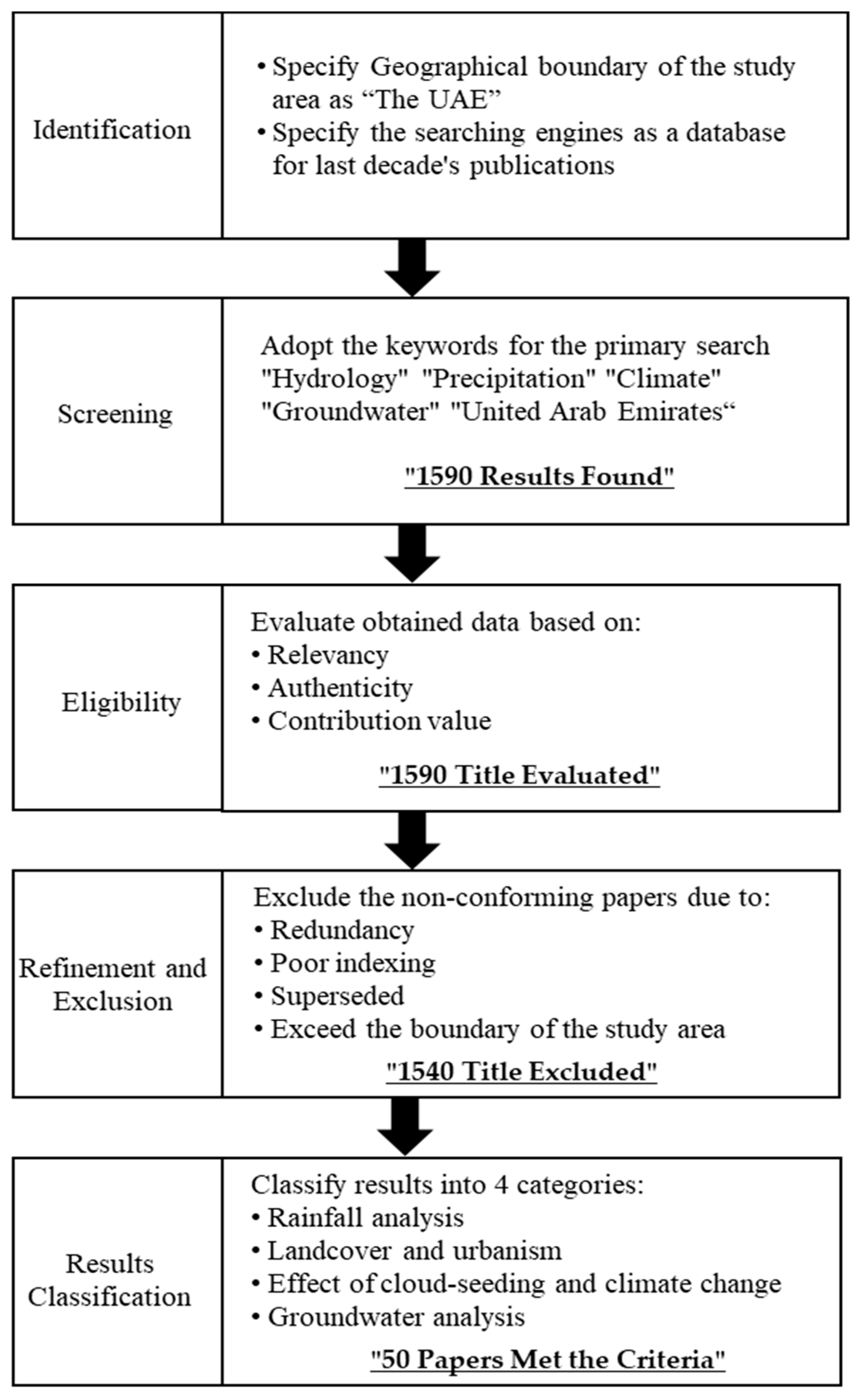
The methodology of this work relies on a bibliometric analysis to gather and evaluate related sources of data, which involve five phases, as shown in Figure 4. The first phase is the identification, which involves specifying the geographical boundary of the study area as the UAE and adopting Google Scholar as a database with a major focus on the last decade’s publications. The second phase represents the screening processes that revolve around adopting the following keywords as the primary search (“hydrology,” “precipitation,” “climate,” “groundwater,” and “United Arab Emirates”). The third phase deals with the eligibility of the findings by evaluating the obtained data based on relevance, authenticity, and contribution value. The fourth phase refines and excludes the non-conforming papers if they are redundant, poorly indexed, superseded, or not related to the geographical boundary of the study area, while the fifth and last phase classifies the results into four distinguished categories as follows:
- Rainfall analysis;
- Urban growth and flood hazards;
- Cloud seeding and changing climate;
- Groundwater situation and utilization.
The classification and elimination approaches enabled filtering of the obtained data from a total of 1590 results in the third phase to 50 in the fifth phase. The following sections will discuss the researchers’ contributions in each category and present their primary outcomes and recommendations [4].
3. Main Findings
3.1. Rainfall Analysis
Understanding rainfall characteristics represents the first key to solving many complex issues related to the design and performance of storm drainage networks. It also enables government authorities and community members to adopt rational actions to tackle several socioeconomic challenges associated with precipitation and urban flood impacts. In this context, scientific research guided by the three pioneer universities in the UAE, the United Arab Emirates University, Sharjah University, and Heriot-Watt University Dubai, succeeded in analyzing several hydrological challenges and presenting applicable solutions to enhance the community’s welfare and sustainability, especially in the last decade. The following two sections summarize the main contributions of 10 influential published papers related to precipitations and rainfall analysis in the UAE.
3.1.1. Rainfall Characteristics in the UAE
Rainfall characteristics revolve around precipitation amount, the historical pattern of rain in terms of intensity and duration, and the geographical distribution of rain over a specified zone. The absence of comprehensive meteorological records for the UAE negatively impacted the abilities of the specialist to produce trustworthy research until they managed to establish new integrated databases relying on the advancements in artificial intelligence and machine learning to infill missing records (Almheiri et al. [6]).
Feulner [7] presented the oldest study related to rainfall characteristics in the UAE to explore climatic periodicity in the country based on Sharjah Airport’s historical daily rainfall records. The author referred back to the old Sharjah airport records that started in 1934, combined with the available records until 2004. The study tried to better understand rainfall patterns in the country as part of the comprehensive scenario of destructive wadies and urban floods. The study presented historical records of rainfall and climate for Sharjah over 80 years that create an important reference for obtaining essential meteorological records for Sharjah and the related surrounding regions.
Sherif et al. [8] addressed the spatial and temporal characteristics of rainfall for the four climatic regions of the UAE: the east coast, the mountainous area, gravel plains, and the desert foreland. The researchers prepared the Intensity Duration Frequency (IDF) relationships for these regions based on a comprehensive analysis of the country’s annual rainfall records from 42 rain gauge stations. The study found that in 2014, the average yearly rainfall in UAE ranged between 80 and 140 mm, and rainfall characteristics in the four regions of the UAE match in patterns but differ in magnitudes, which demonstrated the inter-regional variability of rainfall characteristics in the UAE. The uniqueness is that it relates rainfall characteristics to the climatic regions in the country, which reflects the actual situation despite the short physical distances between them. Therefore, specialists and consultancy firms should study the different characteristics of each region before constructing any hydrological projects.
Ouarda et al. [9] evaluated the rainfall regime in the UAE based on historical daily rainfall records of four meteorological stations at the airports of Abu Dhabi, Dubai, Sharjah, and Ras Al Khaima. The recorded period extends between 30 and 37 years, and the analysis relies mainly on the Mann–Kendall test [10] to assess the rainfall trends, besides three other secondary methods. The results illustrate that annual rainfall shows decreasing trends for all stations, where February and March contain the most important trends. They suggested expanding the study to include rainfall analysis on the regional level to achieve a comprehensive analysis scenario that enables the comparison and integration of records and outcomes.
Steinhoff et al. [11] conducted a study on summer rainfall in the UAE, which lacks previous studies and exploration. The investigation was relayed on the Climate Forecast System Reanalysis (CFSR) and Weather Research and Forecasting model (WRF) simulations. The researchers succeeded in identifying the causative factors of summer rains in the UAE by simulating the impact of the southwest Asian monsoon and the buildup of Arabian Heat Low (AHL), which initiate those seasonal rainy events. The study presented a simulation of the rain events of 30 to 31 August 2011, supported by the generated climatological maps.
Yilmaz et al. [12] discussed the rainfall trends in Sharjah city and derived the intensity–duration–frequency (IDF) relationship. The study successfully utilized the limited sources of climatic data to derive IDF relationships by fitting extreme values of rainfall records. The analysis found that rainfall trends over the city decreased for short-duration (<6 h) storms, while insignificant trends were observed for the longer-duration (>12 h) storms. The study delivered a generally applicable methodology to update IDF curve values supported by detailed figures. However, researchers strongly recommended adopting reliable meteorological data from more than one station to obtain better results on the local and regional levels. The results have contributed to efforts to reassess the performance of the storm drainage networks based on the newly obtained results.
3.1.2. Satellite Rainfall Data
Rainfall records remain the attention topic of most hydrological studies, and they are mainly obtained from ground rain-gaged stations. However, due to the shortage of the geographical distribution of ground weather stations or the gaps in the historical records, satellite rainfall data represent an alternative source of records that can be used to create a comprehensive set of records with the aid of remote-sensing techniques and the applications of artificial intelligence.
The existing weather stations in the UAE showed an obvious shortage in their historical data records due to the relatively short age of their establishments and the limitations of their spatial distributions. Therefore, researchers seek to bridge these gaps by integrating the available precipitation records with those provided globally by satellite observation data.
Kumar and Ouarda [13] looked at the rainfall regime in the UAE from a different perspective by exploring the impact of equatorial Pacific Sea Surface Temperatures (SSTs) on the country’s precipitation variability, such as the amount, time, and intensity of rainfall events. The study compared the precipitation records of six local weather stations in the UAE with the relevant data from the Climate Prediction Center Merged Analysis of Precipitation (CMAP) from 1981 to 2011. The results showed that the warming of the ocean surface in the central and eastern tropical Pacific Ocean has a direct correlation with most monthly winter precipitation variability of the UAE.
Wehbe et al. [14] investigated the validity and consistency of data from four global precipitation products over the actual daily precipitation records of 53 weather stations in the UAE. The four products were the Tropical Rainfall Measuring Mission (TRMM) Multi-Satellite Precipitation Analysis (TMPA), the Climate Prediction Center MORPHing technique (CMORPH), the Global Precipitation Climatology Centre (GPCC), and Willmott and Matsuura (WM). On the other hand, the 53 stations represented different climactic conditions of the UAE due to their geographical distributions and included records from 2003 to 2010. Among the four products, TMPA led to the best agreement with actual observations of the adopted ground stations, with higher correlations in values for stations located in the northeastern lands (>250 m) compared with lower western stations.
In the same context, Hussein et al. [15] presented a study to examine the reliability of three satellite-based precipitation products compared with the historical records of 18 rain-gaged stations in the UAE over a period of seventeen years. The researchers found that rainfall data obtained from some satellite reading products proved to be accurate and reliable, such as those obtained from the Climate Prediction Center Morphing Technique (CMORPH). In addition, researchers found that the integrated precipitation data obtained from multi-satellite observations can substitute the gaps in ground station data, especially for further studies related to rainfall frequency analysis and water resources planning. This notion aligns with the efforts of Adeloye and Rustum [1] and Mwale et al. [2] in infilling and reconstructing meteorological data.
Mahmoud et al. [16] conducted a study to validate the accuracy and efficiency of the Global Precipitation Measurement (GPM) satellite in measuring rainfall precipitations compared with ground weather stations. The study found that the records of the GPM IMERG (Integrated Multi-Satellite Retrievals from Global Precipitation Measurement) proved to be accurate, reliable, and have more comprehensive coverage zones than ground stations. However, researchers indicated essential gaps in implementing these techniques, such as inaccurate estimation of the precipitation over the eastern and northeastern parts of the UAE due to the natural topography. They then recommended adding new ground meteorological stations in these areas to enhance the quality of data and tackle the previously mentioned issue.
Yilmaz and Shabib [17] conducted a significant study on the projection of rainfall and temperature for Sharjah city in the UAE. The study relied on two sources of meteorological data: the Global Climate Models (GCMs) and the locally observed data from 1981 to 2015. The study introduced GCMs for the first time in local studies. These models are essential research tools that enable conducting detailed studies and simulations on the local and regional levels. The study figured that Sharjah’s air temperatures are anticipated to increase by 12–17% in the near and far future, while the average rainfall is expected to decrease between 1 and 53%.
3.1.3. Suggestions for Future Studies in the Field of Rainfall Analysis
Rainfall analyses is the first topic reviewed in this paper and researchers in the UAE focused on documenting precipitation records of the country, enhancing the quality of these records, exploring rainfall characteristics, and analyzing rainfall trends based on the available data of the ground rain-gaged stations that covers part of the geographical area of the country. However, the issues of rainfall forecasting and modeling to simulate a country’s rainfall behavior using big meteorological data are not yet explored in the country and the region. The study conducted by Fathi et al. [18] succeeded in obtaining and implementing big meteorological data using a Systematic Literature Review (SLR) approach. The study applied the inclusion and exclusion criteria process that reviewed 185 published papers in the initial stage and selected 35 papers that complied with these criteria. The results showed that big data analysis substantially improves weather forecasting compared to traditional statistical methods.
3.2. Urban Growth and Flood Hazards
Urban development requires careful attention to establish the balance between growth requirements and the efficiency of infrastructure performance, considering the actual capacity, coverage, and design criteria. The establishment of an effective storm drainage network is considered to be one of the major challenges facing cities, especially in those with rapid urban growth patterns. The increase in urbanization, lax planning laws for construction in flood plains, and the inadequacy of storm drainage facilities represent some of the causative factors of urban floods (Adeloye and Rustum [1]). The researchers in the UAE placed remarkable efforts to identify the gaps associated with rapid urbanism and proposing relevant solutions to achieve the community’s comprehensive, balanced development. The following two sections summarize the contributions of twelve published papers related to land cover, urbanism, and urban floods in the UAE.
3.2.1. Hydrological Issues Associated with Urban Growth
Urban growth is one of the criteria associated with economic success; however, it is usually combined with several hydrological and environmental challenges, such as the increase in population and the expansion of the physical built-up area. This increases the demand for groundwater and requires continuous enhancement of the storm drainage network and urban flood precautions. On the other hand, such issues motivated researchers to address them and present successful solutions to mitigate the impacts related to this growth.
Alsenaani [19] assessed the existing natural hazards in the UAE and classified them into four major subjects: tsunamis, flooding, sand/dust storms, and climate change. The study relied on a qualitative method to carry out a flood risk assessment due to the lack of historical data related to the occurrence of floods and their characteristics. The researchers succeeded in generating unique hazard maps for each subject relying on a literature review, engineering judgment based on the limited available reports, and a newly developed risk matrix. They found that the northern and northeastern zones of the UAE are subjected to higher flooding risks due to the relatively large numbers of wadies and the low infiltration rates of mountain rocks.
In his efforts to chart the potential of landscape urbanism of Dubai, Bolleter [20] partially discussed the city’s experience in urban floods after rainfall events. Despite the importance of establishing beautiful landscape projects in the city, it is significant to ensure that these projects support the sustainable initiatives launched by the city, especially those related to the blue-green infrastructure projects. The study emphasized the importance of adopting a comprehensive structure of development where institutions, human resources, and technical capabilities need to be reformulated to achieve sustainable community development. In addition, it is essential to ensure that the storm drainage network remains clear and ready to function all the time due to the possibility of getting blocked by sand or other substances which hinder the ideal performance of the network.
Elmahdy and Mohamed [21] studied the land-cover changes in Ajman city as a result of urban growth and assessed its impacts on groundwater quality and quantity by employing image transformation and the Spectral Angle Mapper (SAM) algorithm on two sets of satellite images: the Shuttle Radar Topography Mission (SRTM) and the Enhanced Thematic Mapper Landsat (ETM+). The study first traced urban changes in the city over 15 years and then correlated these data with Total Dissolved Solid (TDS) in the groundwater such as calcium (Ca), magnesium (Mg), nitrate (NO3), sulfate (SO4), and chloride (Cl). The study showed that urban growth in Ajman had negatively impacted the quality and depth of groundwater levels, which requires implementing urgent legislation to enhance the characteristics of groundwater in the city.
Shanableh et al. [22] studied the impact of urban expansion on urban flooding and water harvesting in Sharjah. The study confirmed that the four-time increase in built-up areas coincided with a ten-fold increase in population growth over the same period. Thus, it negatively affected fractions of impervious lands, water storage capacity, and potential runoff areas. The physical structures of urban development led to further urban floods with an even less amount of rain. The researchers emphasized aligning the construction of a storm drainage network with the urban development schemes of the city to maintain the required sustainability and urban security standards. Therefore, multilevel sustainable solutions can be addressed to maintain the targeted standards of community welfare and security.
Shanableh et al. [23] developed another significant study on the effect of land-cover change on urban floods and rainwater harvesting in Sharjah, the UAE. The study traced urban development growth between 1976 and 2016, which dramatically increased the built-up area four-fold. They developed a flood map for the study area to assess urbanism’s impact on different land-use zones, and they found that the industrial zone is more sensitive to urban floods compared to the other land uses. The study clearly showed the shortage in stormwater network coverage and the lack of other alternative sustainable infrastructural solutions.
Al Abdouli et al. [24] studied the impact of urban growth over runoff volumes using Integrated Multi-Satellite Retrievals for Global Precipitation Measurement Mission (IMERG) rainfall records. The study aimed to assess the possibility of recharging runoff water to the underground reservoirs of freshwater instead of the current practice of building rainwater drainage channels and discharging the annual volume of rains to the sea, which is estimated to be 0.11 km3 and 0.48 km3 for the 5-year and 100-year storms, respectively. They discussed the environmental and economic benefits of injecting excess rainfall into the ground to restore the natural balance and considered the side benefits of reducing the impacts of the annual urban floods.
Mohamed et al. [25] evaluated the impact of the urban growth of Abu Dhabi city on water supply and demand to 2050 based on four sustainable scenarios: Business as Usual (BAU), Policy First (PF), Sustainability by Conservation (SC), and Rainfall-Enhanced Sustainability (RES). The study analyzed the opportunities and limitations of each scenario, supported by simulations results which showed that both SC and RES scenarios would reach a balanced water budget up to 2050 as a target year of the study. Although the results represent scenarios for the water management of Abu Dhabi city, they can be considered an important reference study for other cities in the UAE.
Elmahdy et al. [26] presented a successful approach to map and monitor land-use/land-cover (LULC) changes to explore their impacts on groundwater level and quality in the northern part of the UAE. The study obtained aerial image data from 1990 to 2018 and integrated them with the related hydrological information such as groundwater level, nitrate concentration NO3, and the Total Dissolved Solids (TDS) using a support vector machine (SVM) and spectral analysis mapper (SAM) classifiers. The (SMA) classifier was found to be more efficient than the (SVM) in mapping LULC on the regional scale. The results documented and confirmed dramatic LULC changes associated with remarkable population growth over the study period. Thus, increasing the demand for water resources affected the quantity and quality of groundwater in urbanized areas. The over-pumping of groundwater caused a reduction in the water level and increased the (TDS) concentration.
Liaqat et al. [27] evaluated the impact of urban expansion on the demand for groundwater resources in Al Ain city from 2006 to 2016. The demand is classified based on the requirements of land-use growth, which is obtained by tracing the changes on satellite data over the study period. The study found that urban areas had expanded by 10.49%, which resulted in a 22.22% increase in the demand for groundwater. Relatively, a 7.38% and 5.88% increase in the coverage areas of agriculture farms and garden playgrounds caused an increase in groundwater demands by 9.56% and 8.89%, respectively. Simultaneously, the depth of the groundwater level declined by 40.44%, which was validated by 52 field visits to water wells in the city. It is important to maintain continuous coordination between urban planning and water consumption authorities to avoid future complications in the sustainability of natural resources.
Tayara et al. [28] studied the feasibility of reusing greywater in existing buildings as a sustainable initiative in supplying part of the needs associated with urban growth. The study assessed four types of buildings: a high-rise residential tower, a school, a hotel, and a house of worship. The study shows effective results in preserving natural water resources and proven feasibility success, especially if combined with government incentives to property owners. This approach requires a local adoption campaign in multilevel stages to gain community support and trust.
3.2.2. Flood Hazards
Flood hazards are closely linked to the devastating impacts associated with them as a natural phenomenon on society, the economy, and the environment. With the global increase in population and urbanized areas, researchers started to investigate the ways and means to mitigate flood impacts by understanding their natural characteristics and occurrence patterns. Such efforts, if linked to other climatic changes and human factors, can help hydrologists to propose sustainable development plans that serve cities’ urban development vision. However, only two papers were found to be related to urban flood hazards in the UAE despite the repetitive events of seawater flooding due to tsunamis, such as the 2022 summer events on the east coast of the country.
El-Hussain et al. [29] evaluated the possible hazards caused by the Probable Maximum Tsunami (PMT) on the coast of the Diba zone opposing the Indian Ocean. The study mentioned a remarkable recorded tsunami event on 27 November 1945, of which requires serious investigation to ensure the current and future safety of the community and developments. The researchers presented two scenarios of the anticipated impacts that could be caused by earthquakes in the east of the Makran Subduction Zone.
Yagoub et al. [30] relied on a text mining program to extract data from five local newspapers related to flooding events in Fujairah as part of the efforts to document urban flood hazards in the UAE. These data are classified, revised, compared with actual events, and fed into a GIS database to create a flood-prone map. The study succeeded in documenting a map and other essential records based on 18 years of text mining that were validated and found reliable, which represents a part of the solution to tackle the absence of flood record events in the UAE.
The limited number of published papers related to flood hazards in the UAE necessitates launching initiatives to encourage further exploration of the topic. For example, the Ministry of Energy and Infrastructure and other local authorities could lead the efforts to support the scientific investigation of the abovementioned complications based on a prioritized methodology to mitigate hazards. The anticipated methodology can confine all the hydrological problems associated with urbanism and specify the causative factors for each issue. Following that, a new scientific forum can be established to include specialists in public, private, and academic sectors to collaborate and propose state-of-the-art solutions relying on advancements in scientific research and the use of robots and artificial intelligence. This step supports UAE Centennial 2071 to make the country the best in the world in its first centennial.
3.2.3. Suggestions for Future Studies in the Fields of Urban Growth and Flood Hazards
Urban growth flood hazards are the second topic discussed in the current review, where most of the studies revolved around investigating the impact of urban growth on runoff areas, flood volumes, and possible scenarios of utilizing these quantities of rainfall volumes. However, the complications associated with the socioeconomic impacts of urban floods on different cities of the UAE have not been investigated yet. For instance, Martínez-Gomariz et al. [31] investigated the potential socioeconomic effects of urban flood in Badalona city in Spain. The researchers first established a detailed 1D and 2D hydrological model for the city to estimate flood volumes over different return periods, then explored the intangible social impacts associated with the city’s flood and the tangible economic damages accompanied by these events. Such type of research is highly recommended to be conducted in the UAE to quantify the socioeconomic losses accompanying the repetitive annual urban floods in the country.
3.3. Cloud Seeding and Changing Climate
Cloud seeding represents a human intervention in weather modification to achieve certain goals and objectives, whereas changing climate mainly refers to the continuous shift in climatic indices due to a combination of natural and non-natural factors. According to Vélez-León [32], the modification of weather occurs when human activities are intentionally employed to alter the environment; it is founded on the concept that when the right quantities of seeding materials are introduced into the clouds, the process of precipitation will be altered. The practice is also known as weather intervention. The research arena in the UAE developed important studies related to the importance and impacts of cloud seeding and the related issues to the changing climate. The following two sections summarize the efforts of 11 published papers on the effect of cloud seeding and climate change in the UAE. The diversity and broad context of the topics discussed in these studies represent a solid base foundation for climatic benchmarking studies between the UAE and other countries or centers in the region.
3.3.1. Cloud-Seeding Studies in the UAE
Cloud seeding is a national strategic program in the UAE to meet part of the country’s water needs by increasing precipitation. The program was initially launched in 2010 and registered success in increasing precipitation compared to the pre-cloud-seeding era (Almheiri et al. [6]). It represents one of the alternative solutions for combating water scarcity and the anticipated effect of climate change over the medium and long term. However, cloud seeding also produces secondary environmental and hydrological impacts which require continuous monitoring and evaluation to mitigate their impacts.
Kumar and Suzuki [33] presented a pioneer study on assessing seasonal cloud properties to support cloud-seeding efforts in the UAE by indicating the thermodynamic phase of clouds. They adopted two geostationary satellites to provide a comprehensive regional scan, and the analysis indicated the appropriate locations for cloud harvesting and increasing precipitation. The study found that it is possible to harvest clouds in the rainy months of both winter and summer. In addition, the study recommended the following points to enhance precipitation using cloud-seeding techniques:
- Consider cloud localization differences in summer and winter.
- Trace the occurrence of liquid and ice clouds over different geographical locations.
- Specify the effective cloud radius on both land and sea locations.
- Adopt hygroscopic seeding techniques to increase precipitation in summer, especially over the northeastern region of UAE.
- Reassess the role of high mountains in the UAE in the creation of convective clouds.
Farahat and Abuelgasim [34] investigated the impact of the 2017 cloud-seeding missions on air quality in the UAE. The study traced the daily mean of particulate matter (PM10 and PM2.5) before and after implementing cloud-seeding operations. The term particulate matter refers to a mixture of tiny solid particles and liquid droplets in the air. These matters may range in size and composition from large dust particles to microscopic ones that are no larger than 2.5 μm in diameter. Based on the results of 20 air-monitoring stations, the PM10 increased significantly in all stations during the month of the operation. The particulate matter was found to be silver iodine crystals that failed to alter the clouds and fell as particles of different sizes. The study recommended considering the direct and indirect effects of these particulates on the overall environmental system in the country.
Almheiri et al. [6] presented the first study to assess the impact of cloud seeding on the intensity–duration–frequency (IDF) curves of Sharjah city. The study succeeded first in extending reliable historical rainfall records for the study area based on the self-organizing map approach. This resulted in the addition of 21 years of hourly rainfall data to the city’s historical record, improving the efficacy and reliability of future design studies in the region. Their analysis then proved that cloud-seeding operations increased IDF curve values when compared with pre-cloud-seeding missions. The study recommended updating the IDF curves regularly to monitor any changes that may impact the design and operation criteria of the stormwater drainage network, especially in regions similar to the UAE that adopt cloud-seeding missions.
Al Hosari et al. [35] presented a statistical and physical evaluation study for cloud-seeding operations in the UAE. The study compared the historical rainfall records of the targeted areas before and after implementing the cloud-seeding program. They combined these results with other data from polarimetric weather radars in Abu Dhabi, Al Ain, and Dubai. They found that the average precipitation increased by 23% within 15 to 25 min of the cloud-seeding mission. In addition, the study mentioned that the National Center of Meteorology established the UAE Research Program for Rain Enhancement Science (UAEREP) in 2015 to support the scientific research of cloud seeding and encourage the implementation of advanced technology in this field. UAEREP provides grant support for innovative research into the region’s weather and rainfall conditions.
Airey et al. [36] introduced a novel approach to UAE to enhance precipitations based on understanding the evolution of rain droplets from the cloud. They utilized ceilometer observation data of 2018–2020 and succeeded in specifying the required conditions for successful precipitations within and below clouds, taking into consideration the original size of the droplets and the thermodynamic shape under the cloud. The study has contributed to the efforts of cloud seeding in the country and has increased the efficiency of the missions.
Fonseca et al. [37] examined the use of the Weather Research and Forecasting (WRF) model to guide cloud-seeding operations by simulating the forecasted optimal conditions for the seeding missions such as the type of cloud, the moisture ratio, and the air temperature. The study evaluated the model’s predictions compared to the data of 46 meteorological stations in the UAE based on 15 min records. It is found the results of the simulation model achieved more accurate results depending on the (WRF) data, which can add value to the efficiency of cloud-seeding missions in the region.
3.3.2. Climate Change Studies in the UAE
Chandran et al. [38] studied the impact of global climate oscillation on the UAE’s temperature and precipitation. The study first obtained the following essential data:
- Monthly precipitation records from six ground meteorological stations in the UAE from 1982 to 2010.
- Monthly precipitation records from the Global Precipitation Climatology Centre (GPCC) from January 1901 to December 2010.
- Land surface temperatures from Global Historical Climatology Network (GHCN) from 1948 to 2016.
- Surface air pressure from four climate indices: the Southern Oscillation Index (SOI), the Indian Ocean Dipole Index (IOD), the North Atlantic Oscillation Index (NAO), and the East Atlantic Oscillation Index (EAO).
The study investigated the possibility of relying on the climate indices to forecast the winter precipitation and summer temperatures in the UAE. In addition, the (SOI) and the (NAO) indexes were found to be reliable compared with the results obtained from the local meteorological stations adopted in the study.
Chowdhury et al. [39] evaluated nine hydro-climate parameters in the northeastern region of the UAE to provide a better understanding of the climate conditions and trends in the study area. These parameters were:
- Maximum daily mean temperature (T-mean).
- Maximum daily temperature (T-max).
- Minimum daily temperature (T-min).
- Annual daily Maximum Mean Sea Level Pressure (MSLP).
- Annual daily Maximum mean relative humidity (H-mean).
- Annual daily maximum rainfall (Rainfall).
- Annual daily maximum mean visibility (V-mean).
- Annual daily maximum mean wind speed (WS-mean).
- Annual daily Maximum of Sustained Wind Speed (MSWS).
The study observed a generally increasing trend in (T-mean), (T-max), (T-min), (MSLP), and (Rainfall) compared to a decreasing trend in (H-mean), (V-mean) and (WS-mean). On the other hand, the (MSWS) showed an increasing trend in Fujairah and a decreasing trend in Ras Al Khaimah. The researchers suggested expanding the assessment to include a broader area which allows for the investigation of the results in a regional context.
Basarir et al. [40] investigated the effect of the current and future climate change in the UAE based on meteorological factors, temperature, and precipitation. The historical records of two meteorological stations located in Abu Dhabi and Al Ain were investigated to judge the trend in annual average temperature and precipitation from 1972 to 2014. The results indicated a significant increase in temperature and a stable trend in precipitation over the study period.
Almazroui et al. [41] investigated future climate changes over the Arabian Peninsula. They relied on meteorological data from 25 stations in Saudi Arabia from 1981 to 2010, anticipating changes in temperature and precipitations. They analyzed the multi-model ensemble from 31 CMIP6 models, which observed an increasing temperature (0.51 °C decade-1) and a decreasing tendency in precipitation (6.3 mm decade-1) over the Arabian Peninsula. These findings help generate a common understanding of a big part of the UAE as it is located in the southeastern part of the Arabian Peninsula.
Oyounalsoud et al. [42] assessed the meteorological drought in Sharjah city as a natural disaster impacting the environment in its broad context. The study analyzed the historical rainfall record of Sharjah since 1981 and expanded the analysis to include the projected rainfall records up to 2099. The researchers evaluated the data based on the Reconnaissance Drought Index (RDI) and the Standardized Precipitation Index (SPI). Both indexes indicated dryer trends over the periods of the study.
3.3.3. Suggestions for Future Studies in the Fields of Cloud Seeding and Changing Climate
Cloud seeding and changing climate represent the third topic of the current documentary analysis. The researchers attempted to document the UAE’s efforts in developing a cloud-seeding program and exploring the hydrological consequences associated with this program, such as pollution, the increase in rainfall intensities, and enhancing the harvesting techniques. However, other issues, such as the economic feasibility of cloud seeding in the UAE need to be addressed to enhance the sustainability and efficiency of the program. In addition, changing-climate studies require collaborative efforts of researchers to specify the short- and long-term challenges of climate change in the region and organize their scientific efforts to address these challenges, especially in urban areas. Salimi and Al-Ghamdi [43] presented an important study to explore the main impacts of climate change in urbanized regions of the Middle East and suggested climate change adaptation strategies to create more resilient urban environments. This step is crucial to accelerate the efforts of scientific research toward specifically defined topics such as the rise of temperature, the fluctuation of precipitation rates, and the rise of wet-bulb temperature.
3.4. Groundwater Situation and Utilization
Understanding the characteristics of groundwater aquifers, especially their recharge potential, is important if they are to be protected from excessive depletion by the growing population demands. Local researchers discussed the related issues of groundwater mapping, modeling, recharging, dam locations, and other hydrological topics to provide a broader understanding of the actual situation and open new paths to search and explore.
Groundwater studies in the UAE will always remain a priority, where the increase in population implies continuous pressure on the strategic resources of the country. The following three sections summarize the contributions of 17 published papers on groundwater analysis in the UAE.
3.4.1. Groundwater Mapping
Groundwater mapping involves the assessment of water resource conditions and consumption scenarios in the region (Elbeih [44]). Mohamed et al. [45] presented a modified approach for groundwater potentiality mapping (GWPM) based on fuzzy logic in GIS and Multia-Criteria Decision Making (MCDM) in Al Fo’ah area, located in Al Ain. Despite the limitation of the study’s area, researchers succeeded in implementing nine groundwater conditioning factors and assigning a weight for each factor related to its contributions to groundwater buildup using Analytic Hierarchy Process (AHP). These factors were slope, altitude, lithology, distance to faults, distance to paleochannels, soil texture, topographic wetness index, topographic curvature, and land cover. The produced map of the potential locations of groundwater was validated by the Relative Operating Characteristics (ROCs) method and was found to be reliable.
Al-Ruzouq et al. [46] discussed the importance of investigating groundwater resources in the northern UAE to find alternative solutions to water scarcity in the arid climate of the UAE. The study initially mentioned eight weighted factors associated with water accumulation: elevation, slope, precipitation, geology, geomorphology, drainage stream density, major fractures, and lineament density. These factors were explored using an analytical hierarchy process supported by a machine learning technique to develop a groundwater potential map (GPM), which contained five zones representing the potential quantities of groundwater locations ranked from the highest to the lowest. The analysis showed that geology, precipitation, and geomorphology were the major factors to contribute to water accumulation over the study area.
3.4.2. Groundwater Budget and Recharge Models
Considering the scarcity of water resources in the UAE, a water budget model represents an essential tool to illustrate the flow of water into and out of their natural storage areas. The ability to control the quantities of natural water consumed and recharged within a specific zone allows for one to think of the sustainable scenarios of water consumption based on the supply and demand of water in that specific zone.
Mohamed [47] presented a conceptual, strategic study of the Water Budget Model (WBM) of Al Ain city. The study aims to analyze the components of the city’s (WBM) by comparing the budget’s input and output volumes. The input flow of the model comprised desalinated water, leakage from the distribution network, precipitation, groundwater inflow from Omani Mountains, treated sewerage water, and deep wells pumping. The simulation of the budget showed that the output flow represents half of the volume of the input flow due to the excessive use of desalinated water for domestic uses and irrigation, which resulted in a noticeable increase in groundwater level. The study recommended the reinvestigation of the component of the (WBM) in Al Ain over a longer period to propose a sustainable strategy for water management.
Rizk et al. [48] conducted a sample study on the ability of dams in the UAE to contribute to the artificial recharge of groundwater. The study involved Al-Wurrayah and Tawiyean dams in Fujairah and relied on isotopic mass balance to quantify the dams’ contribution to water recharge. The results showed that these dams had a recharge ratio of 22% to 43%, which is relatively low due to the high evaporation rate regime in the region. Therefore, it is recommended to use injection wells instead to achieve higher recharge rates and implement the recommended environmental safety measures to avoid pollution matters that could occur during these processes.
Gonzalez et al. [49] conducted a study to assess the components of the water budget in the UAE to understand the actual situation of groundwater quantities and their contribution to the country’s needs. The study evaluated the water budget components that included precipitation, desalinated water, and evapotranspiration from 2003 to 2012. They found that groundwater storage decreases annually due to excessive use by the populace and agriculture. They emphasize that recycled water uses need a comprehensive assessment as they have the potential to enhance the water budget by supplying certain purposes of the community’s demands instead of directly relying on groundwater.
Sathish et al. [50] presented their efforts in developing a groundwater flow model for Abu Dhabi emirate. The model represents the actual recharge and discharge scenario based on ten-year records of groundwater levels. The study extends over the emirate area, representing more than 80% of the UAE’s total area. The model enabled researchers to comprehensively analyze the study area by considering five major hydrological factors: recharge by rainfall, freshwater production, subsurface inflow, drainage transmission loss, and discharge due to community uses. The analysis showed that groundwater levels would continue to decrease due to higher discharge rates and they recommended reorganizing groundwater management to avoid further challenges in the future.
Sherif et al. [51] developed a pioneer groundwater recharge map for the UAE by assessing the potential for groundwater recharge and monitoring the relevant water levels. The process involves hydrological techniques depending on infiltration rate, soil type, ground slope, geological/hydrogeological factors, and rainfall-harvesting infrastructure. The study found that the annual groundwater recharge in the UAE is 133 million cubic meters based on the potential recharge method, GIS tools, and remote-sensing techniques.
Abrams et al. [52] presented their integrated approach to exploring groundwater potential (GWP) in the northern part of the UAE using multilayers of modeling procedures. Due to the large scale of the study area and the diversity of its terrain, the researchers relied on remote-sensing techniques to obtain and establish the required spatial data to establish the (GWP) thematic layers. These data included elevation, slope, curvature, drainage density, topographic wetness index (TWI), lineament density, land cover, accumulated precipitation, and groundwater-induced cool thermal anomaly frequency (CTA). The study adopted the following methods to establish (GWP) maps: Simple Additive Weight (SAW), Probabilistic Frequency Ratios (PFR), and the Analytical Hierarchy Process (AHP). These maps were validated by field visits and previous data from 645 water wells. The highest (GWP) zone was found to be in the center of Dubai and Sharjah emirates due to the high precipitation records and other physiographic factors for groundwater accumulation.
Al-Ruzouq et al. [53] conducted a significant study related to dam site suitability mapping in Sharjah. The study aims to produce a dam site suitability map (DSSM) relying on GIS tools to determine the best dam locations supported by machine learning (ML) techniques. The initial stage required developing a special database that contains a study area map, aerial image, meteorological data, in situ groundwater records, and nine thematic weighted factors related to groundwater accumulation. These factors were precipitation, drainage stream density, geomorphology, geology, curve number, total dissolved solids, elevation, slope, and major fracture Euclidean distance. The produced (DSSM) was compared with the actual site locations of the constructed dams in the study area, which showed an agreement of 83.3% of the studies recommendations. Precipitation and drainage stream density were the dominating factors determining the most appropriate sites among the adopted thematic factors of the study.
Murad et al. [54] studied the infiltration rate upstream and downstream of Wadi Al Bih in Ras Al Khaimah to assess the hydraulic conductivity of soil layers as part of the groundwater recharge process and examine the relationship between precipitation and the downward movement of rainwater through the soil layers. The evaluation depended on a double-ring infiltration test and borehole investigations. The average infiltration rate was found to be almost similar on both sides of the wadi; however, the average conductivity downstream was found to be (39.67 cm/s), which is four times the value of upstream due to the effect of mud and the characteristics of soil layers in absorbing surface water.
Yilmaz et al. [55] studied the spatiotemporal trend in groundwater levels for 11 well fields in Sharjah city over 15 years. These fields were Al Sadiyah, Aweed, Bedai, Filli, Ghuraifa, Hamdah, Madam, Mahafis, Sajaa, Seih Aqareb, and Seih Hermal. The study aimed to identify patterns in the levels of groundwater during the study period, which can be used for future decisions related to water management. The researchers relied on MK non-parametric test analysis, which showed that the groundwater levels had decreasing trends in all 11 investigated fields. In addition, groundwater production showed another significant decreasing trend, which reached 90% in the Aweed water field. The study discussed the impact of salinization, which represents another challenge related to water quality in the UAE.
Valjarević et al. [56] explored the possibility of determining dew volumes and harvesting zones in the UAE as a renewable, natural resource; this can increase the quantities of water feeding the budget model of the country besides precipitation. The study relied on theoretical approaches using GIS and remote sensing. The researchers succeeded in identifying the possible harvesting zones and encouraged exploring the harvesting techniques as part of enhancing the sustainability of water resources management in the country.
Al-Ruzouq et al. [57] presented a novel strategic study to produce Artificial Groundwater Recharge (AGR) sites for the northern emirates of the UAE. The researchers’ approaches depend on gathering historical meteorological records; the GIS database; remote-sensing images; and nine thematic parameters that are precipitation, drainage stream density, the geometry of the land, geology of the study area, groundwater level, total dissolved solids, elevation, lineament density, and resident Euclidean distance. These nine parameters provide weight and processes, and rely on the advances in artificial intelligence techniques to produce the intended recharge map. The developed (AGR) map of the UAE contains six distinguished regions that are suitable to be recharged, ranked from very high to very low.
3.4.3. Groundwater Quality
Despite the available quantities of groundwater storage sites, the issues of water suitability for uses and the hydrochemical characteristics of the water remain critical factors in determining whether to use, protect or avoid these quantities. Mohamed et al. [58] presented a comprehensive approach to trace the natural and anthropogenic factors impacting groundwater quality. The study used remote-sensing images and GIS data and involved essential natural elements such as the chemical composition of the host rock and flow directions. Specifying and evaluating the natural and anthropogenic factors, such as groundwater flow directions and human activities in agriculture and industries, enabled the generation of detailed maps to illustrate the impact on the regional scale.
Ahmed et al. [59] presented a strategic study of the hydrochemical characteristics of groundwater in Dubai. The study focuses on creating a groundwater quality database for sustainable groundwater management in the city. The study analyzed 70 groundwater samples and classified them into zones (fresh to brackish and saline towards the shoreline sabkhas). They then proposed a general outline policy for groundwater management in Dubai which contains seven aims revolving around quantifying the groundwater budget, recognizing aquifer flows, increasing public awareness to preserve groundwater, improving water consumption management, redeveloping the related managerial practices, simulating water budget, and adopting water protection parameters.
Khan et al. [60] studied the hydrochemistry characteristics of groundwater in two adjacent agricultural regions in Abu Dhabi, Remah and Al Khatim. The study aimed to evaluate the suitability of the existing groundwater in these regions for agricultural purposes based on its chemical characteristics. The extensive depletion of groundwater for irrigation and the overuse of chemical fertilizers directly impacted the quality of water in the study area. The water table in Al Khatim is found to be shallower than in Ramah due to the differences in surface elevation and soil permeability, which increased the salinity in Al Khatim due to the backflow of irrigation water. The evaluation involved measuring the sodium percentage, sodium adsorption ratio, salinity hazards, magnesium hazard, and Kelly’s index (KI) to measure the presence of sodium compared to calcium and magnesium. Generally, groundwater in both regions was found to be unsuitable or unsafe and can only be used for salt-tolerant trees but not for the common local crops. Therefore, it recommended implementing new farming techniques, such as the hydroponic and aquaponic methods, which consume less water and provide a controlled agricultural environment.
Kayemah et al. [61] presented their efforts in evaluating groundwater quality in Sharjah. The study showed the city’s natural challenges due to its location and climatic characteristics. The increasing demand for water consumption due to population growth and low precipitation rates represent the major challenges for the city. The researchers provided a significant analysis for 11 water-well fields in the study area and generated helpful maps and tables that can be used for further research. The Ground Water Quality Index showed significant results in 8 out of the 11 water well fields. However, salinity represents the most critical challenge that faces these fields.
3.4.4. Suggestions for Future Studies in the Fields of Groundwater Situation and Utilization
The groundwater situation and utilization is the fourth topic of this review, which presents UAE’s recent studies of groundwater mapping, groundwater budget, recharge modeling, and groundwater quality. These papers addressed significant hydrological issues related to the characteristics and challenges of groundwater aquifers in the country. However, the impact of newly established dams on the recharge of water along valley flow paths needs to be assessed, such as Al Shuwaib and Siji dams located in Al Ain and Fujerah, respectively. In addition, exploring alternative resources to recharge groundwater layers is needed to support the efforts of sustainable water management and climate change adaptation. Shawaqfah et al. [62] explored the possibility of using treated wastewater to recharge groundwater in one of the well fields in Jordan. The study relied on developing a simulation model to assess the recharge process’ efficiency and the location’s suitability. The results found that 5% of the total area of the study was suitable for water recharging, encouraging the further assessment of different locations. Therefore, it is helpful to implement the previous methods in different locations of the UAE as part of enhancing the water budget supply in the country.
4. Conclusions
The local scientific research field contains capable specialists and researchers interested in enhancing the efficiency of hydrological research affairs in the UAE. The individual contribution of each research effort represents an essential element in the overall structure of knowledge building. This paper focused on presenting a documentary analysis of the hydrological literature in the UAE published on Google Scholar. A bibliometric methodology combined with keyword search was used to gather and refine results based on their relevance, authenticity, and contribution value.
It selected 50 published papers as the highly categorized papers based on their direct impact on the local hydrological field of the UAE. The selected papers were then categorized and presented on four main topics: rainfall analysis, urban growth and flood hazards, cloud seeding and changing climate, and groundwater situation and utilization. A summary of the relevant papers is presented on each topic, including the paper’s aim and main results. The analysis is enriched by relating the outcomes with the local issues the authors are aware of. It is important to declare that the cited documents contain additional rich information that can be referred to but are not included fully in our analysis.
The outcomes of these papers have succeeded in addressing several important hydrological challenges in the UAE, exploring the unknown factors causing these complications, and providing efficient solutions to tackle these issues. However, we recommend addressing crucial gaps in the hydrological literature of the UAE, specifically exploring the advantages of big meteorological data analysis in rainfall forecasting and modeling, assessing the socioeconomic impacts of urban floods on different cities of the UAE, investigating the short- and long-term impacts of climate change in the urbanized area, and exploring alternative resources to recharge groundwater layers to support the efforts of sustainable water management and climate change adaptation.
Author Contributions
Conceptualization, R.R. and K.B.A.; methodology, R.R. and K.B.A.; investigation, K.B.A.; resources, K.B.A.; writing—original draft preparation, K.B.A.; writing—review and editing, R.R. and A.J.A.; visualization, K.B.A.; supervision, R.R. and G.W. All authors have read and agreed to the published version of the manuscript.
Funding
This research received no external funding.
Data Availability Statement
Not applicable.
Acknowledgments
We thank the Federal Geographical Information Center in the UAE for developing the required maps for this study. We also want to show our appreciation to the National Center of Meteorology for providing the required information related to automated weather stations in the country. We extend our gratitude to Anwaar Al Shimmari (Executive Director) for her efforts in facilitating the procedures of obtaining the spatial data for this study.
Conflicts of Interest
The authors declare no conflict of interest.
Appendix A
Table A1 below presents a list of the UAE automated weather stations that includes their names, locations, elevations, ID numbers, and installation dates.

Table A1.
A list of the UAE’s automated weather stations.
| No. | Region | Cities | AWS ID | AWS Name | LAT | LON | Elevation (m) | Installation Date |
|---|---|---|---|---|---|---|---|---|
| 1 | ABU DHABI | Abu Dhabi | 124 | ABU AL ABYAD | 24 12 22 | 53 47 27 | 2 | 01-09-2005 |
| 2 | Abu Dhabi | 026 | ABU DHABI | 24 28 38 | 54 19 40 | 3 | 31-12-2004 | |
| 3 | Abu Dhabi | 395 | ADNOC HQ | 24 27 43 | 54 19 26 | 342 | 06-112019 | |
| 4 | Al Wathbah | 202 | AL_WATHBAH | 24 07 52 | 54 48 42 | 80 | 31-12-2002 | |
| 5 | Al Wathbah | 108 | ALWATHBAH2 | 24 07 52 | 54 48 42 | 80 | 31-12-2002 | |
| 6 | Al Ain Settlement | 215 | AL AJBAN | 24 36 28 | 54 53 18 | 61 | 21-12-2014 | |
| 7 | Abu Dhabi | 389 | AL HAFFAR | 23 56 16 | 54 43 25 | 80 | 04-04-2019 | |
| 8 | Abu Dhabi | 397 | AL HAFFAR 2 | 23 56 16 | 54 43 25 | 98 | 01-07-2020 | |
| 9 | Abu Dhabi | 408 | AL HAFFAR 3 | 25 75 9 | 54 44 55 | 165 | 09-07-2021 | |
| 10 | Abu Dhabi | 409 | AL HAFFAR 4 | 25 75 9 | 54 44 55 | 165 | 22-07-2021 | |
| 11 | Musaffah District | 390 | AL MUSAFFAH | 24 22 18 | 54 28 00 | 1 | 14-05-2019 | |
| 12 | Al Ruwais Industrial City | 030 | AL QLAA | 24 09 19 | 52 58 47 | 20 | 31-12-2002 | |
| 13 | Al Ruwais Industrial City | 402 | AL QLAA 2 | 24 8 49 | 52 58 33 | 150 | 06-02-2021 | |
| 14 | Abu Dhabi | 214 | AL RASS | 24 27 15 | 54 19 03 | 34 | 27-102014 | |
| 15 | Abu Dhabi | 205 | ALREEM ISLAND | 24 29 46 | 54 24 31 | 300 | 01-08-2013 | |
| 16 | Al Shawamekh Disreict | 372 | AL SHAWAMEKH | 24 20 18 | 54 38 25 | 11 | 06-09-2017 | |
| 17 | Abu Dhabi | 206 | ASHAAB | 24 23 11 | 54 48 44 | 35 | 04-12-2012 | |
| 18 | Abu Dhabi | 123 | RAS GANADAH | 24 50 11 | 54 46 00 | 5 | 06-09-2005 | |
| 19 | Al Sout | 020 | REZEEN | 23 40 39 | 54 44 44 | 99 | 31-12-2002 | |
| 20 | AL AIN | Al Ain | 399 | AL AMERAH | 24 14 08 | 55 32 23 | 202 | 27-07-2020 |
| 21 | Al Ain | 388 | AL AIN | 24 12 57 | 55 47 37 | 300 | 03-07-2007 | |
| 22 | Swiehan | 003 | SWIEHAN | 24 27 58 | 55 19 53 | 150 | 30-11-2002 | |
| 23 | Al Ain | 218 | UAE UNIVERSITY | 24 11 42 | 55 40 44 | 249 | 08-04-2015 | |
| 24 | Umalzimul | 016 | UM AZIMUL | 22 42 51 | 55 08 19 | 120 | 31-12-2002 | |
| 25 | Al Ain | 129 | UM GHAFA | 24 04 00 | 55 55 60 | 371 | 21-09-2006 | |
| 26 | Al Ain | 008 | MEZYED | 24 01 43 | 55 50 52 | 316 | 31-12-2002 | |
| 27 | Al Ain | 010 | KHATAM AL SHAKLAH | 24 12 40 | 55 57 07 | 410 | 31-12-2002 | |
| 28 | Al Ain | 034 | RAKNAH | 24 20 44 | 55 42 29 | 265 | 31-12-2002 | |
| 29 | Al Ain Settlement | 006 | AL KHAZNA | 24 07 29 | 55 06 48 | 170 | 31-12-2002 | |
| 30 | Al Ain | 011 | ALFOAH | 24 22 05 | 55 48 43 | 313 | 31-12-2002 | |
| 31 | Al Arad | 014 | ALARAAD | 23 50 41 | 55 31 27 | 170 | 31-12-2002 | |
| 32 | Al Ain District | 005 | AL FAQA | 24 43 08 | 55 37 17 | 215 | 31-12-2002 | |
| 33 | Al Qattarah District | 128 | AL QATARA | 24 15 58 | 55 45 20 | 281 | 08-07-2006 | |
| 34 | Al Qattarah District | 015 | ALQUAA | 23 23 36 | 55 25 10 | 131 | 31-12-2002 | |
| 35 | Al Shuwaib District | 012 | AL SHIWEB | 24 46 34 | 55 47 53 | 306 | 31-12-2002 | |
| 36 | Al Ain | 216 | AL SHUAIBAH | 24 06 50 | 55 36 26 | 215 | 12-01-2015 | |
| 37 | Al Ain | 132 | DAMSA | 24 10 48 | 55 24 48 | 163 | 12-01-2008 | |
| 38 | Umalzimul | 137 | GASYOURA | 22 49 43 | 54 49 10 | 99 | 03-05-2010 | |
| 39 | Al Ain | 354 | JABAL HAFEET 2 | 24 03 24 | 55 46 31 | 1095 | 31-12-2002 | |
| 40 | AL DHAFRA | Ghiathi | 019 | OWTAID | 23 23 44 | 53 06 10 | 160 | 31-12-2002 |
| 41 | Al Sila | 121 | RAS MUSHERIB | 24 19 48 | 51 39 00 | 22 | 17-10-2004 | |
| 42 | Al Ruwais | 143 | AL RUWAIS | 24 05 36 | 52 37 23 | 23 | 27-01-2011 | |
| 43 | Al Daffrah | 404 | AL MIRFA | 24 05 09 | 53 32 15 | 10 | 11-04-2021 | |
| 44 | AL DAFRAH | 023 | AL JAZEERA B.G | 23 17 28 | 52 17 20 | 70 | 31-12-2002 | |
| 45 | Al Ruwais Industrial City | 392 | Bada Dafas | 23 49 58 | 53 09 55 | 97 | 16-07-2019 | |
| 46 | Arjan | 391 | ARJAN | 23 50 10 | 54 28 39 | 94 | 19-06-2019 | |
| 47 | Hamim | 017 | HAMIM | 22 58 25 | 54 18 10 | 114 | 31-12-2002 | |
| 48 | Jabal Al Dannah | 405 | JABAL AL DHANNA | 24 09 56 | 52 38 15 | 10 | 20-04-2021 | |
| 49 | Ras Ghumeis | 400 | Ras Gumeis | 24 20 54 | 51 36 15 | 3 | 22-10-2020 | |
| 50 | Barakhah | 356 | BARAKAH | 23 57 19 | 52 15 59 | 5 | 31-07-2016 | |
| 51 | Barakhah | 357 | BARAKAH 60 | 23 57 19 | 52 15 59 | 5 | 25-01-2017 | |
| 52 | Barakhah | 403 | BARAKAH SITE | 23 57 53 | 52 14 46 | 5 | 29-03-2021 | |
| 53 | Bu Hamrah | 028 | BU HUMRAH | 23 30 21 | 54 31 48 | 140 | 31-12-2002 | |
| 54 | AL DAFRAH | 022 | AL GHEWEIFAT | 24 07 16 | 51 37 37 | 45 | 31-12-2002 | |
| 55 | Mukhairaz | 024 | MUKHAIRAZ | 22 55 48 | 52 52 12 | 125 | 31-12-2002 | |
| 56 | Qaser Al Sarab | 422 | TAL AL SARAB | 22 48 58 | 54 14 59 | 240 | 03-01-2022 | |
| 57 | Madinat Zayed | 018 | MADINAT ZAYED | 23 40 54 | 53 41 55 | 110 | 31-12-2002 | |
| 58 | Mezairah | 114 | MEZAIRA | 23 08 42 | 53 46 43 | 204 | 15-06-2003 | |
| 59 | DUBAI | Dubai | 371 | MARGHAM | 24 53 03 | 55 33 00 | 171 | 31-07-2017 |
| 60 | Dubai | 370 | JUMEIRAH | 25 05 20 | 55 08 08 | 5 | 06-07-2017 | |
| 61 | Dubai | 376 | TAWEELA 2 | 24 46 49 | 54 44 27 | 40 | 06-01-2018 | |
| 62 | Dubai | 377 | TAWEELA 3 | 24 46 49 | 54 44 27 | 15 | 06-01-2018 | |
| 63 | Dubai | 385 | LAHBAB | 25 01 45 | 55 36 47 | 136 | 10-12-2018 | |
| 64 | Dubai | 102 | SAIH AL SALEM | 24 49 39 | 55 18 43 | 80 | 31-12-2002 | |
| 65 | Dubai | 401 | Al Marmoom | 25 00 08 | 55 30 48 | 110 | 30-12-2020 | |
| 66 | Dubai | 107 | HATTA | 24 48 44 | 56 08 23 | 295 | 31-12-2002 | |
| 67 | Madinat Al Maktoum | 406 | EXPO 2020 | 24 57 17 | 55 09 19 | 20 | 26-07-2021 | |
| 68 | Dubai | 208 | BURJ KHALIFAH | 25 11 56 | 55 16 23 | 625 | 17-02-2013 | |
| 69 | SHARJAH | Al Dhaid City | 135 | AL DHAID | 25 14 13 | 55 49 01 | 100 | 17-02-2010 |
| 70 | Mleiha Sector | 109 | AL MALAIHA | 25 07 50 | 55 53 17 | 155 | 31-12-2002 | |
| 71 | Kalba | 384 | KALBA | 25 00 18 | 56 20 06 | 19 | 21-11-2018 | |
| 72 | ISLANDS | Makasib Island | 113 | MAKASIB | 24 39 59 | 51 49 27 | 3 | 05-05-2003 |
| 73 | Qarnen Island | 027 | QARNEN | 24 56 20 | 52 50 53 | 49 | 31-12-2002 | |
| 74 | Sir Bani Yas Island | 108 | SIR BANI YAS | 24 19 01 | 52 35 52 | 130 | 31-12-2002 | |
| 75 | SIR BU NAIR ISLAND | 126 | SIR BU NAIR | 25 13 12 | 54 13 02 | 7 | 06-02-2006 | |
| 76 | Yasat Island | 201 | YASAT-2 | 24 11 11 | 51 59 42 | 13 | 04-09-2005 | |
| 77 | Aryla Island | 219 | ARYLA | 24 59 20 | 54 12 48 | 10 | 29-03-2015 | |
| 78 | Arzana Island | 398 | ARZANA ISLAND | 24 48 06 | 52 33 23 | 5 | 07-05-2020 | |
| 79 | Dalma Isaland | 112 | DALMA | 24 29 27 | 52 17 29 | 6 | 04-05-2003 | |
| 80 | Das Isaland | 115 | DAS ISLAND | 25 09 00 | 52 52 17 | 5 | 26-06-2003 | |
| 81 | Dayyinah Island | 387 | DAYYINAH ISLAND | 24 57 10 | 52 24 01 | 4 | 28-03-2019 | |
| 82 | Abu Al Bukhoosh | 355 | ABU AL BUKOOSH 2 | 25 29 42 | 53 08 45 | 37 | 19-01-2004 | |
| 83 | Abu Dhabi | 131 | AL ARYAM | 24 18 30 | 54 10 19 | 10 | 25-12-2007 | |
| 84 | Abu Dhabi | 407 | AL BAZAM | 24 19 13 | 53 4 56 | 3 | 30-07-2021 | |
| 85 | AJMAN | Ajman | 212 | AJMAN | 25 25 25 | 55 26 41 | 3 | 21-04-2013 |
| 86 | Al Manama | 105 | MANAMA | 25 19 34 | 56 00 22 | 200 | 31-12-2002 | |
| 87 | FUJAIRAH | Fujairah | 373 | AL FARFAR | 25 09 59 | 56 10 34 | 721 | 05-112017 |
| 88 | Fujairah | 118 | AL HEBEN | 25 07 33 | 56 09 27 | 935 | 22-08-2016 | |
| 89 | Dadnah | 031 | DHUDNA | 25 30 40 | 56 19 29 | 45 | 31-12-2002 | |
| 90 | Dibba Al Fujairah | 381 | DIBBA | 25 34 30 | 56 13 34 | 48 | 06-11-2018 | |
| 91 | Fujairah | 217 | FUJAIRAH PORT | 25 10 21 | 56 21 40 | 10 | 22-04-2015 | |
| 92 | Al Tawian Settlement | 104 | TAWIYEEN | 25 33 36 | 56 04 13 | 152 | 31-12-2002 | |
| 93 | Fujairah | 386 | KHOR FAKKAN PORT | 25 21 28 | 56 21 50 | 6 | 20-02-2019 | |
| 94 | UAQ | Umm Al Qawian | 111 | UMM AL QUWAIN | 25 31 60 | 55 39 13 | 13 | 27-04-2003 |
| 95 | Falaj Al Moalla | 106 | FALAJ AL MOALLA | 25 20 16 | 55 51 58 | 105 | 31-12-2002 | |
| 96 | RAS AL KHAIMAH | Al Marjan District | 393 | AL MARJAN | 25 41 24 | 55 43 53 | 5 | 04-08-2019 |
| 97 | Al Qawr | 200 | AL QOR | 24 54 23 | 56 09 07 | 230 | 01-01-2001 | |
| 98 | Ras Al Khaimah | 110 | JABAL JAIS | 25 57 00 | 56 10 20 | 1710 | 31-12-2002 | |
| 99 | Ras Al Khaimah | 133 | JAIS2 | 25 57 00 | 56 10 20 | 1710 | 31-12-2002 | |
| 100 | Ras Al Khaimah | 116 | JABAL MEBREH | 25 38 53 | 56 07 51 | 1480 | 04-08-2003 | |
| 101 | Ras Al Khaimah | 352 | JABAL YANAS | 25 43 55 | 56 05 40 | 811 | 12-10-2015 | |
| 102 | Ras Al Khaimah | 353 | RAS AL KHAIMAH | 25 46 18 | 55 56 21 | 3 | 10-11-2015 | |
| 103 | Ras Al Khaimah | 210 | SAQR PORT | 25 58 37 | 56 03 24 | 5 | 15-01-2013 | |
| 104 | Shoukah | 204 | SHOUKAH | 25 06 21 | 56 02 53 | 323 | 23-09-2012 | |
| 105 | Umm al Qhaff | 394 | UMM ALGHAF | 24 52 34 | 56 16 43 | 100 | 23-09-2019 | |
| 106 | Wadi Tuwa | 207 | WADI AL TUWA | 25 01 20 | 56 07 35 | 370 | 09-12-2012 | |
| 107 | Ras Al Khaimah | 379 | WADI SHAHAH | 25 54 10 | 56 08 08 | 551 | 16-04-2018 | |
| 108 | Masafi | 033 | MASAFI | 25 22 22 | 56 09 53 | 516 | 31-12-2002 |
References
- Adeloye, A.J.; Rustum, R. Lagos (Nigeria) flooding and influence of urban planning. Proc. Inst. Civ. Eng. Urban. Des. Plan. 2011, 164, 175–187. [Google Scholar] [CrossRef]
- Mwale, F.D.; Adeloye, A.J.; Rustum, R. Infilling of Missing Rainfall and Streamflow—A Self Organizing Map Approach; British Hydrological Society: Exeter, UK, 2012; pp. 1–4. [Google Scholar] [CrossRef]
- The UAE Federal Geographical Information Center. Political Map of the UAE; The UAE Federal Geographical Information Center: Abu Dhabi, United Arab Emirates, 2023. [Google Scholar]
- Aldababseh, A.; Temimi, M. Analysis of the long-term variability of poor visibility events in the UAE and the link with climate dynamics. Atmosphere 2017, 8, 242. [Google Scholar] [CrossRef]
- The National Center of Meteorology of the UAE. Map of the Locations of Meteorological Weather Stations, The UAE; The National Center of Meteorology of the UAE: Abu Dhabi, United Arab Emirates, 2023. [Google Scholar]
- Almheiri, K.B.; Rustum, R.; Wright, G.; Adeloye, A.J. Study of impact of cloud-seeding on intensity-duration-frequency (IDF) curves of Sharjah city, the United Arab Emirates. Water 2021, 13, 3363. [Google Scholar] [CrossRef]
- Feulner, G.R. Rainfall and Climate Records from Sharjah Airport: Historical Data for the Study of Recent Climatic Periodicity in the U.A.E. In Tribulus 16.1 Spring/Summer; Emirates Natural History Group: Abu Dhabi, United Arab Emirates, 2006; Volume 16.1, pp. 3–9. Available online: http://enhg.org/Portals/1/trib/V16N1/TribulusV16N1.pdf (accessed on 10 May 2023).
- Sherif, M.; Almulla, M.; Shetty, A.; Chowdhury, R.K. Analysis of rainfall, PMP and drought in the United Arab Emirates. Int. J. Clim. 2013, 34, 1318–1328. [Google Scholar] [CrossRef]
- Ouarda, T.; Charron, C.; Kumar, K.N.; Marpu, P.; Ghedira, H.; Molini, A.; Khayal, I. Evolution of the rainfall regime in the United Arab Emirates. J. Hydrol. 2014, 514, 258–270. [Google Scholar] [CrossRef]
- Jhajharia, D.; Dinpashoh, Y.; Kahya, E.; Choudhary, R.R.; Singh, V.P. Trends in temperature over Godavari River basin in Southern Peninsular India. Int. J. Clim. 2013, 34, 1369–1384. [Google Scholar] [CrossRef]
- Steinhoff, D.F.; Bruintjes, R.; Hacker, J.; Keller, T.; Williams, C.; Jensen, T.; Al Mandous, A.; Al Yazeedi, O.A. Influences of the Monsoon Trough and Arabian Heat Low on Summer Rainfall over the United Arab Emirates. Mon. Weather. Rev. 2018, 146, 1383–1403. [Google Scholar] [CrossRef]
- Merabtene, T.; Atabay, S.; Kayemah, N. Rainfall trends and intensity-frequency-duration relationships in Sharjah City, UAE. Int. J. Hydrol. Sci. Technol. 2020, 10, 487. [Google Scholar]
- Kumar, K.N.; Ouarda, T.B.M.J. Precipitation variability over UAE and global SST teleconnections. J. Geophys. Res. Atmos. 2014, 119, 10313–10322. [Google Scholar] [CrossRef]
- Wehbe, Y.; Ghebreyesus, D.; Temimi, M.; Milewski, A.; Al Mandous, A. Assessment of the consistency among global precipitation products over the United Arab Emirates. J. Hydrol. Reg. Stud. 2017, 12, 122–135. [Google Scholar] [CrossRef]
- Hussein, K.A.; Alsumaiti, T.S.; Ghebreyesus, D.T.; Sharif, H.O.; Abdalati, W. High-Resolution Spatiotemporal Trend Analysis of Precipitation Using Satellite-Based Products over the United Arab Emirates. Water 2021, 13, 2376. [Google Scholar] [CrossRef]
- Mahmoud, M.T.; Hamouda, M.A.; Mohamed, M.M. Spatiotemporal evaluation of the GPM satellite precipitation products over the United Arab Emirates. Atmos. Res. 2019, 219, 200–212. [Google Scholar] [CrossRef]
- Yilmaz, A.G.; Shabib, A.G. Rainfall and air temperature projections for Sharjah City, United Arab Emirates. Int. J. Water 2019, 13, 60–79. [Google Scholar] [CrossRef]
- Fathi, M.; Kashani, M.H.; Jameii, S.M.; Mahdipour, E. Big Data Analytics in Weather Forecasting: A Systematic Review. Arch. Comput. Methods Eng. 2022, 29, 1247–1275. [Google Scholar] [CrossRef]
- Alsenaani, H. A Risk Based Approach for the Assessment of Natural Hazards in the UAE. Int. J. Sci. World 2013, 3, 79–99. Available online: https://www.sciencepubco.com/index.php/IJSW/article/view/1267 (accessed on 10 May 2023). [CrossRef]
- Bolleter, J. Charting the Potential of Landscape Urbanism in Dubai. Landsc. Res. 2014, 40, 621–642. [Google Scholar] [CrossRef]
- Elmahdy, S.I.; Mohamed, M.M. Land use/land cover change impact on groundwater quantity and quality: A case study of Ajman Emirate, the United Arab Emirates, using remote sensing and GIS. Arab. J. Geosci. 2016, 9, 722. [Google Scholar] [CrossRef]
- Shanableh, A.; Al-Ruzouq, R.; Siddique, M.; Merabtene, T.; Yilmaz, A.; Imteaz, M. Impact of urban expansion on potential flooding, storage and water harvesting in the city of Sharjah, United Arab Emirates. MATEC Web Conf. 2017, 120, 09007. [Google Scholar] [CrossRef]
- AShanableh, A.; Al-Ruzouq, R.; Yilmaz, A.G.; Siddique, M.; Merabtene, T.; Alam Imteaz, M. Effects of Land Cover Change on Urban Floods and Rainwater Harvesting: A Case Study in Sharjah, UAE. Water 2018, 10, 631. [Google Scholar] [CrossRef]
- Al Abdouli, K.; Hussein, K.; Ghebreyesus, D.; Sharif, H.O. Coastal Runoff in the United Arab Emirates—The Hazard and Opportunity. Sustainability 2019, 11, 5406. [Google Scholar] [CrossRef]
- Mohamed, M.M.; El-Shorbagy, W.; Kizhisseri, M.I.; Chowdhury, R.; McDonald, A. Evaluation of policy scenarios for water resources planning and management in an arid region. J. Hydrol. Reg. Stud. 2020, 32, 100758. [Google Scholar] [CrossRef]
- Elmahdy, S.; Mohamed, M.; Ali, T. Land Use/Land Cover Changes Impact on Groundwater Level and Quality in the Northern Part of the United Arab Emirates. Remote Sens. 2020, 12, 1715. [Google Scholar] [CrossRef]
- Liaqat, M.U.; Mohamed, M.M.; Chowdhury, R.; Elmahdy, S.I.; Khan, Q.; Ansari, R. Impact of land use/land cover changes on groundwater resources in Al Ain region of the United Arab Emirates using remote sensing and GIS techniques. Groundw. Sustain. Dev. 2021, 14, 100587. [Google Scholar] [CrossRef]
- Tayara, A.; Shanableh, A.; Atieh, M.A.; Abdallah, M.; Battacharjee, S.; Mustafa, A.; Al Bardan, M. Feasibility and impact of greywater recycling in four types of buildings in Sharjah, United Arab Emirates. IOP Conf. Ser. Earth Environ. Sci. 2021, 725, 012009. [Google Scholar] [CrossRef]
- El-Hussain, I.; Omira, R.; Al-Bulushi, K.; Deif, A.; Al-Habsi, Z.; Al-Rawas, G.; Mohamad, A.; Al-Jabri, K.; Baptista, M.A. Tsunami hazard assessment along Diba-Oman and Diba-Al-Emirates coasts. MATEC Web Conf. 2017, 120, 06007. [Google Scholar] [CrossRef]
- Yagoub, M.M.; Alsereidi, A.A.; Mohamed, E.A.; Periyasamy, P.; Alameri, R.; Aldarmaki, S.; Alhashmi, Y. Newspapers as a validation proxy for GIS modeling in Fujairah, United Arab Emirates: Identifying flood-prone areas. Nat. Hazards 2020, 104, 111–141. [Google Scholar] [CrossRef]
- Martínez-Gomariz, E.; Locatelli, L.; Guerrero, M.; Russo, B.; Martínez, M. Socio-Economic Potential Impacts Due to Urban Pluvial Floods in Badalona (Spain) in a Context of Climate Change. Water 2019, 11, 2658. [Google Scholar] [CrossRef]
- Vélez-León, A. Rain on Demand: Regulating Weather Modification Throughout the United States. 2017. Available online: https://www.nsf.gov/nsb/publications/1965/nsb1265 (accessed on 10 May 2023).
- Kumar, K.N.; Suzuki, K. Assessment of seasonal cloud properties in the United Arab Emirates and adjoining regions from geostationary satellite data. Remote Sens. Environ. 2019, 228, 90–104. [Google Scholar] [CrossRef]
- Abuelgasim, A.; Farahat, A. Investigations on PM10, PM2.5, and Their Ratio over the Emirate of Abu Dhabi, United Arab Emirates. Earth Syst. Environ. 2020, 4, 763–775. [Google Scholar] [CrossRef]
- Al Hosari, T.; Al Mandous, A.; Wehbe, Y.; Shalaby, A.; Al Shamsi, N.; Al Naqbi, H.; Al Yazeedi, O.; Al Mazroui, A.; Farrah, S. The UAE Cloud Seeding Program: A Statistical and Physical Evaluation. Atmosphere 2021, 12, 1013. [Google Scholar] [CrossRef]
- Airey, M.W.; Nicoll, K.A.; Harrison, R.G.; Marlton, G.J. Characteristics of Desert Precipitation in the UAE Derived from a Ceilometer Dataset. Atmosphere 2021, 12, 1245. [Google Scholar] [CrossRef]
- Fonseca, R.; Francis, D.; Nelli, N.; Farrah, S.; Wehbe, Y.; Al Hosari, T.; Al Mazroui, A. Assessment of the WRF Model as a Guidance Tool into Cloud Seeding Operations in the United Arab Emirates. Earth Space Sci. 2022, 9, e2022EA002269. [Google Scholar] [CrossRef]
- Chandran, A.; Basha, G.; Ouarda, T.B.M.J. Influence of climate oscillations on temperature and precipitation over the United Arab Emirates. Int. J. Clim. 2015, 36, 225–235. [Google Scholar] [CrossRef]
- Chowdhury, R.; Mohamed, M.M.; Murad, A. Variability of Extreme Hydro-Climate Parameters in the North-Eastern Region of United Arab Emirates. Procedia Eng. 2016, 154, 639–644. [Google Scholar] [CrossRef]
- Basarir, A.; Arman, H.; Hussein, S.; Murad, A.; Aldahan, A.; Al-Abri, M.A. Trend detection in annual temperature and precipitation using mann–kendall test—A case study to assess climate change in Abu Dhabi, United Arab Emirates. In Proceedings of the 3rd International Sustainable Buildings Symposium (ISBS), Dubai, United Arab Emirates, 15–17 March 2017; pp. 3–12. [Google Scholar] [CrossRef]
- Almazroui, M.; Islam, M.N.; Saeed, S.; Saeed, F.; Ismail, M. Future Changes in Climate over the Arabian Peninsula based on CMIP6 Multimodel Simulations. Earth Syst. Environ. 2020, 4, 611–630. [Google Scholar] [CrossRef]
- Oyounalsoud, M.S.; Najah, A.; Yilmaz, A.G.; Abdallah, M.; Siddique, M. Meteorological Drought Assessment in Sharjah, UAE Using Drought Indices. Int. J. Environ. Sci. Dev. 2022, 13, 16–20. [Google Scholar] [CrossRef]
- Salimi, M.; Al-Ghamdi, S.G. Climate change impacts on critical urban infrastructure and urban resiliency strategies for the Middle East. Sustain. Cities Soc. 2019, 54, 101948. [Google Scholar] [CrossRef]
- Elbeih, S.F. An overview of integrated remote sensing and GIS for groundwater mapping in Egypt. Ain Shams Eng. J. 2015, 6, 1–15. [Google Scholar] [CrossRef]
- Mohamed, M.M.; Elmahdy, S.I. Fuzzy logic and multi-criteria methods for groundwater potentiality mapping at Al Fo’ah area, the United Arab Emirates (UAE): An integrated approach. Geocarto Int. 2016, 32, 1120–1138. [Google Scholar] [CrossRef]
- Al-Ruzouq, R.; Shanableh, A.; Merabtene, T.; Siddique, M.; Khalil, M.A.; Idris, A.; Almulla, E. Potential groundwater zone mapping based on geo-hydrological considerations and multi-criteria spatial analysis: North UAE. Catena 2018, 173, 511–524. [Google Scholar] [CrossRef]
- Mohamed, M.M. An integrated water resources management strategy for Al-Ain City, United Arab Emirates. In IAHS-AISH Proceedings and Reports; IAHS Press: Wallingford, UK, 2014; pp. 273–278. [Google Scholar] [CrossRef]
- Rizk, Z.S.; Garamoon, H. Application of Earth Resistivity, Hydrogeochemistry and Isotope Hydrology Methods for Assessment of Groundwater Recharge in Two Drainage Basins in Northeastern United Arab Emirates Enhancement of Groundwater Recharge from Dams in UAE and KSA View project master thesis View project. IOSR J. Appl. Geol. Geophys. IORS-JAGC 2015, 3, 1–13. [Google Scholar]
- Gonzalez, R.; Ouarda, T.B.M.J.; Marpu, P.R.; Allam, M.M.; Eltahir, E.A.B.; Pearson, S. Water Budget Analysis in Arid Regions, Application to the United Arab Emirates. Water 2016, 8, 415. [Google Scholar] [CrossRef]
- Sathish, S.; Mohamed, M.; Klammler, H. Regional groundwater flow model for Abu Dhabi Emirate: Scenario-based investigation. Environ. Earth Sci. 2018, 77, 409. [Google Scholar] [CrossRef]
- Sherif, M.M.; Ebraheem, A.M.; Al Mulla, M.M.; Shetty, A.V. New system for the assessment of annual groundwater recharge from rainfall in the United Arab Emirates. Environ. Earth Sci. 2018, 77, 412. [Google Scholar] [CrossRef]
- Abrams, W.; Ghoneim, E.; Shew, R.; LaMaskin, T.; Al-Bloushi, K.; Hussein, S.; AbuBakr, M.; Al-Mulla, E.; Al-Awar, M.; El-Baz, F. Delineation of groundwater potential (GWP) in the northern United Arab Emirates and Oman using geospatial technologies in conjunction with Simple Additive Weight (SAW), Analytical Hierarchy Process (AHP), and Probabilistic Frequency Ratio (PFR) techniques. J. Arid. Environ. 2018, 157, 77–96. [Google Scholar] [CrossRef]
- Al-Ruzouq, R.; Shanableh, A.; Yilmaz, A.G.; Idris, A.; Mukherjee, S.; Khalil, M.A.; Gibril, M.B.A. Dam Site Suitability Mapping and Analysis Using an Integrated GIS and Machine Learning Approach. Water 2019, 11, 1880. [Google Scholar] [CrossRef]
- Murad, A.; Hussein, S.; Arman, H.; Gabr, A.; Al Dhuhoori, A. The Aquifer Recharge Potential by Infiltration Tests in Arid Region, Ras Al Khaimah, United Arab Emirates. IOP Conf. Ser. Earth Environ. Sci. 2019, 362, 012017. [Google Scholar] [CrossRef]
- Yilmaz, A.G.; Shanableh, A.; Al-Ruzouq, R.I.; Kayemah, N. Spatio-Temporal Trend Analysis of Groundwater Levels in Sharjah, UAE. Int. J. Environ. Sci. Dev. 2020, 11, 9–14. [Google Scholar] [CrossRef]
- Valjarević, A.; Milanović, M.; Valjarević, D.; Basarin, B.; Gribb, W.; Lukić, T. Geographical information systems and remote sensing methods in the estimation of potential dew volume and its utilization in the United Arab Emirates. Arab. J. Geosci. 2021, 14, 1–15. [Google Scholar] [CrossRef]
- Al-Ruzouq, R.; Shanableh, A.; Yilmaz, A.; Mukherjee, S.; Khalil, M. Multicriteria Spatial Analysis to Map Artificial Groundwater Recharge Zones: Northern UAE; Scitepress: Setúbal, Portugal, 2021; pp. 255–262. [Google Scholar] [CrossRef]
- Mohamed, M.M.; Elmahdy, S.I. Natural and anthropogenic factors affecting groundwater quality in the eastern region of the United Arab Emirates. Arab. J. Geosci. 2014, 8, 7409–7423. [Google Scholar] [CrossRef]
- Ahmed, I.; Tariq, N.; Al Muhery, A. Hydrochemical characterization of groundwater to align with sustainable development goals in the Emirate of Dubai, UAE. Environ. Earth Sci. 2019, 78, 44. [Google Scholar] [CrossRef]
- Khan, Q.; Kalbus, E.; Alshamsi, D.M.; Mohamed, M.M.; Liaqat, M.U. Hydrochemical Analysis of Groundwater in Remah and Al Khatim Regions, United Arab Emirates. Hydrology 2019, 6, 60. [Google Scholar] [CrossRef]
- Kayemah, N.; Al-Ruzouq, R.; Shanableh, A.; Yilmaz, A.G. Evaluation of Groundwater Quality Using Groundwater Quality Index (GWQI) in Sharjah, UAE. E3S Web Conf. 2021, 241, 01005. [Google Scholar] [CrossRef]
- Shawaqfah, M.; Almomani, F.; Al-Rousan, T. Potential Use of Treated Wastewater as Groundwater Recharge Using GIS Techniques and Modeling Tools in Dhuleil-Halabat Well-Field/Jordan. Water 2021, 13, 1581. [Google Scholar] [CrossRef]
Figure 1.
The UAE map.

Figure 2.
The locations of UAE’s meteorological stations.

Figure 3.
The numbers and the geographical distribution of meteorological stations in the UAE.

Figure 4.
Methodology Flowchart.

Disclaimer/Publisher’s Note: The statements, opinions and data contained in all publications are solely those of the individual author(s) and contributor(s) and not of MDPI and/or the editor(s). MDPI and/or the editor(s) disclaim responsibility for any injury to people or property resulting from any ideas, methods, instructions or products referred to in the content. |
© 2023 by the authors. Licensee MDPI, Basel, Switzerland. This article is an open access article distributed under the terms and conditions of the Creative Commons Attribution (CC BY) license (https://creativecommons.org/licenses/by/4.0/).
Share and Cite
MDPI and ACS Style
Almheiri, K.B.; Rustum, R.; Wright, G.; Adeloye, A.J. A Review of Hydrological Studies in the United Arab Emirates. Water 2023, 15, 1850. https://doi.org/10.3390/w15101850
AMA Style
Almheiri KB, Rustum R, Wright G, Adeloye AJ. A Review of Hydrological Studies in the United Arab Emirates. Water. 2023; 15(10):1850. https://doi.org/10.3390/w15101850
Chicago/Turabian StyleAlmheiri, Khalid B., Rabee Rustum, Grant Wright, and Adebayo J. Adeloye. 2023. "A Review of Hydrological Studies in the United Arab Emirates" Water 15, no. 10: 1850. https://doi.org/10.3390/w15101850
Note that from the first issue of 2016, this journal uses article numbers instead of page numbers. See further details here.