Article

Human Health Risk and Quality Assessment of Spring Water Associated with Nitrates, Potentially Toxic Elements, and Fecal Coliforms: A Case from Southern Mexico

by
Manuel Alejandro Colín Carreño
1,
Juan Manuel Esquivel Martínez
2,*,
Edith Rosalba Salcedo Sánchez
2,
Carolina Álvarez Bastida
3,
Jesús Guadalupe Padilla Serrato
1,
Martha Elena Lopezaraiza Mikel
1 and
Óscar Talavera Mendoza
1
1
Facultad de Ecología Marina, Universidad Autónoma de Guerrero, Av. Gran Vía Tropical 20, Las Playas, Acapulco de Juárez 39390, Gro., Mexico
2
CONAHCYT–UAGro, Escuela Superior de Ciencias de la Tierra, Universidad Autónoma de Guerrero, Ex Hacienda San Juan Bautista s/n, Taxco el Viejo 40323, Gro., Mexico
3
Facultad de Ingeniería, Universidad Autónoma del Estado de México, Cerro de Coatepec s/n, Ciudad Universitaria, Toluca de Lerdo 50110, Edo. Méx., Mexico
*
Author to whom correspondence should be addressed.
Water 2023, 15(10), 1863; https://doi.org/10.3390/w15101863
Submission received: 29 March 2023 / Revised: 8 May 2023 / Accepted: 11 May 2023 / Published: 14 May 2023
(This article belongs to the Special Issue Origin, Characterization, and Protection of Spring Water)

Abstract

:
Spring water is important for human consumption, domestic use, agricultural activities, and ecotourism in the Buenavista de Cuéllar Aquifer (ABC), southern Mexico. The objective of this research was to assess the health risk from fecal coliforms, as well as the non-carcinogenic risk to human health for different age groups, by studying the oral and dermal routes. The analysis of the cartography of high-priority springs (the result of Multicriteria Evaluation (MCE)), access routes, and knowledge of the areas with high social insecurity risk enabled the selection of 20 springs to be sampled. In situ parameters were measured, major ions, fecal coliforms, and Potentially Toxic Elements (PTE). The non-carcinogenic health risk results indicated a higher risk by the oral route in children (average Hazard index (HI) value of 0.6371) and a higher risk by the dermal route in adults (average HI value of 1.2378). The highest dermal risks are in the south-southeast of the study area. On the other hand, the assessment of health risks due to fecal coliforms resulted in a medium risk for the dry season and a high risk for the rainy season. The results of this research will serve as a key reference for the management and protection of springs in order to preserve human health.

1. Introduction

Groundwater is essential for human beings throughout the planet. The good quality that is usually associated with groundwater means that it is considered a safe resource for human consumption [1]. However, in recent years, groundwater has been experiencing growing pollution threats contributing to water scarcity and adverse health effects in various countries and arid/semi-arid regions of the world [2,3]. Anthropogenic activities (urbanization, industrial development, agricultural activities, mining exploitation) pose the main threat to groundwater, while geogenic sources represent minor threats [4,5,6]. According to WHO [7], 2 billion people use or consume water polluted with fecal coliforms, nitrates and/or toxic metals. The consequences of consuming polluted water are reflected in a negative impact on human health through water diseases, such as cholera, dysentery, typhoid fever, salmonellosis, diarrhea, blue child syndrome or methemoglobinemia, gastric cancer, congenital disabilities, dental and skeletal fluorosis, cardiovascular disease, renal, and pulmonary [8,9,10,11,12,13,14,15,16,17]. Worldwide, 435 million people drink from unprotected wells and springs; there are 4 billion cases of gastrointestinal diseases and 1 million deaths in children under 5 years of age due to diarrheal diseases; hence, health risk-related research is transcendental in several countries around the world. For example, in countries located in Asia, Africa, North America, and Latin America [18,19,20].
Spring water is considered suitable for human consumption when its quality is good and complies with the maximum permissible limits established by some standard of water for human use and consumption (e.g., WHO 2017; NOM-127-SSA1- 2021). In Mexico, the drinking of polluted water is a threat to the health of the majority of the population that inhabits rural and semi-rural communities. In many regions of Mexico, springs play a fundamental role in water supply, and such is the case of the Buenavista de Cuellar Aquifer (ABC). The ABC is located in the northern portion of the state of Guerrero and is considered a rare case since it is made up of 98% springs, and the main uses are human consumption, domestic, recreation, and agricultural irrigation [21]. The dispersed rural population settled in the aquifer is primarily supplied by springs. Previous studies have analyzed the possible water pollution in the southern portion of the aquifer; for instance: Salcedo et al. [22] evaluated the pollution in a fluvial system, the implications for health, and the ecological risk in the aquatic environment (water surface, groundwater, and sediments); Flores [23] studied the hydrogeochemical processes that control the spring water quality, with emphasis on the recharge processes and water–rock interaction by using stable isotopes. On the other hand, Arroyo et al. [24] assessed spring water for human consumption and analyzed the concentration of Potentially Toxic Elements (PTE) and isotopic compositions. In general, the aforementioned studies did not pay enough attention to health risk assessment, and their results show that mining waste has not influenced the geochemical composition of spring water.
In previous research [25,26,27], the risk to health has been analyzed from different perspectives. In this paper, the health risk index was used, which considers chronic daily intake (CDI), the hazard quotient (HQ), and the hazard index (HI) [6,28,29,30,31,32] and is one of the most widely used methods in various research projects due to its reliability. The majority of studies generally analyze Potentially Toxic Elements (PTE), nitrates, and microbiological parameters separately [33,34,35], but all these factors should be evaluated together when studying springs.
Given the priority of the springs to be sampled, this study shows a spatial analysis based on the combination of the Multicriteria Evaluation (MCE) and Geographic Information Systems (GIS). MCE is a set of techniques (e.g., analytical hierarchical process (AHP)) that are used to select alternatives that best satisfy preferences based on an objective and the analysis of different criteria [36,37]. A high number of worldwide investigations have been conducted, and multi-criteria methods have been implemented on issues related to groundwater management to select optimal sites [38,39,40]. The AHP is a mathematical tool for the spatial evaluation of multiple criteria according to the research objective; the AHP has a lot of applications in groundwater-related research and has been very popular in recent decades because it considers expert opinion [41,42].
This research aimed to assess the non-carcinogenic human health risk by the oral and dermal routes for some age groups and the health risk due to fecal coliforms based on the analysis of the spring water quality (presence of Nitrates, PTE, and fecal coliforms) in the Buenavista de Cuéllar Aquifer, Mexico. In addition, MCE was applied in a GIS environment to prioritize springs and select sampling sites, a completely new approach. It is important to mention that the water samples were collected during the dry and rainy seasons. This study can provide significant elements for the sustainable protection of spring water quality and to prevent waterborne diseases, and may also assist the water authorities (e.g., CONAGUA in Mexico) in modifying pollution regulations, evaluating metals, and revising the groundwater management plan currently in place.

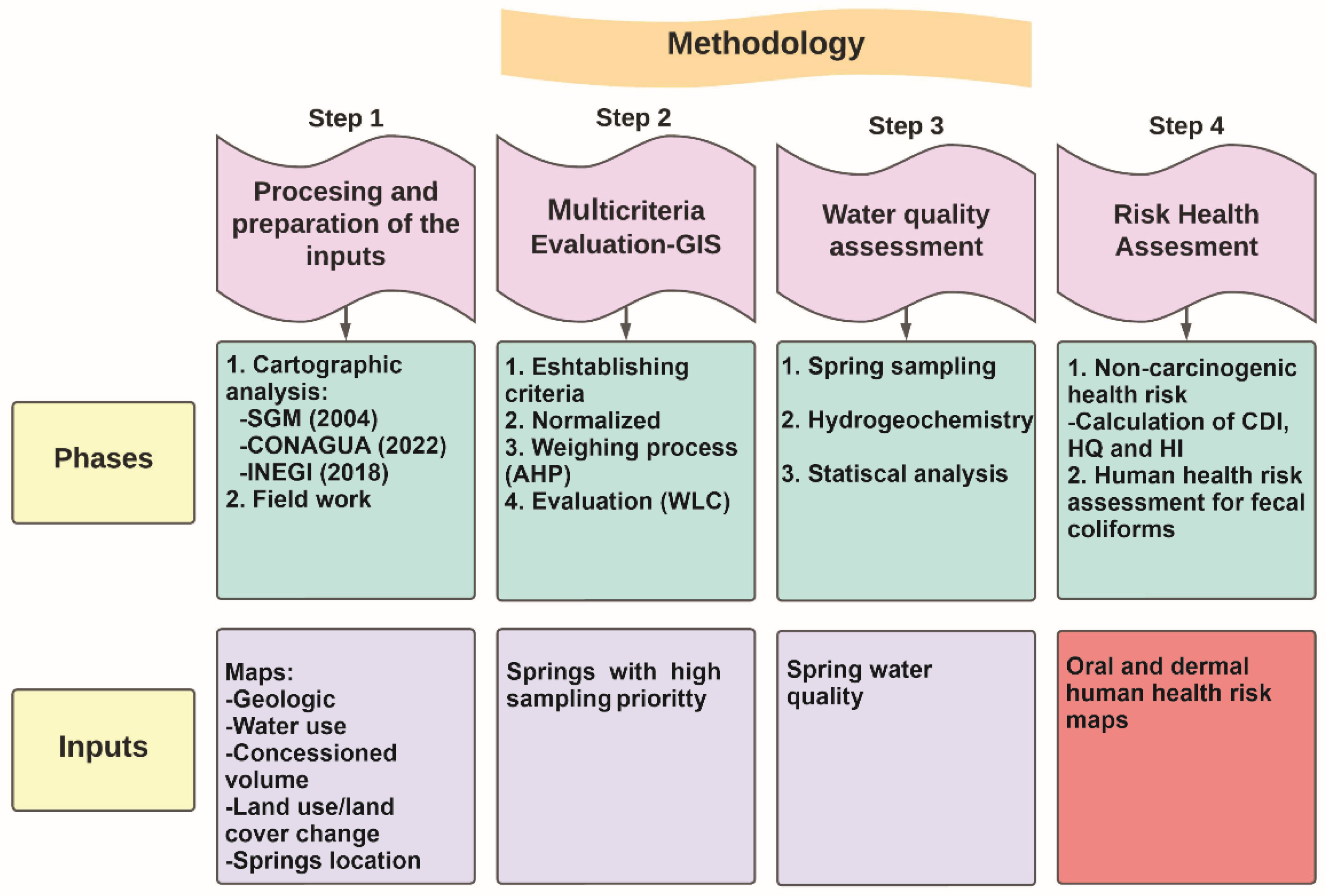
2. Materials and Methods
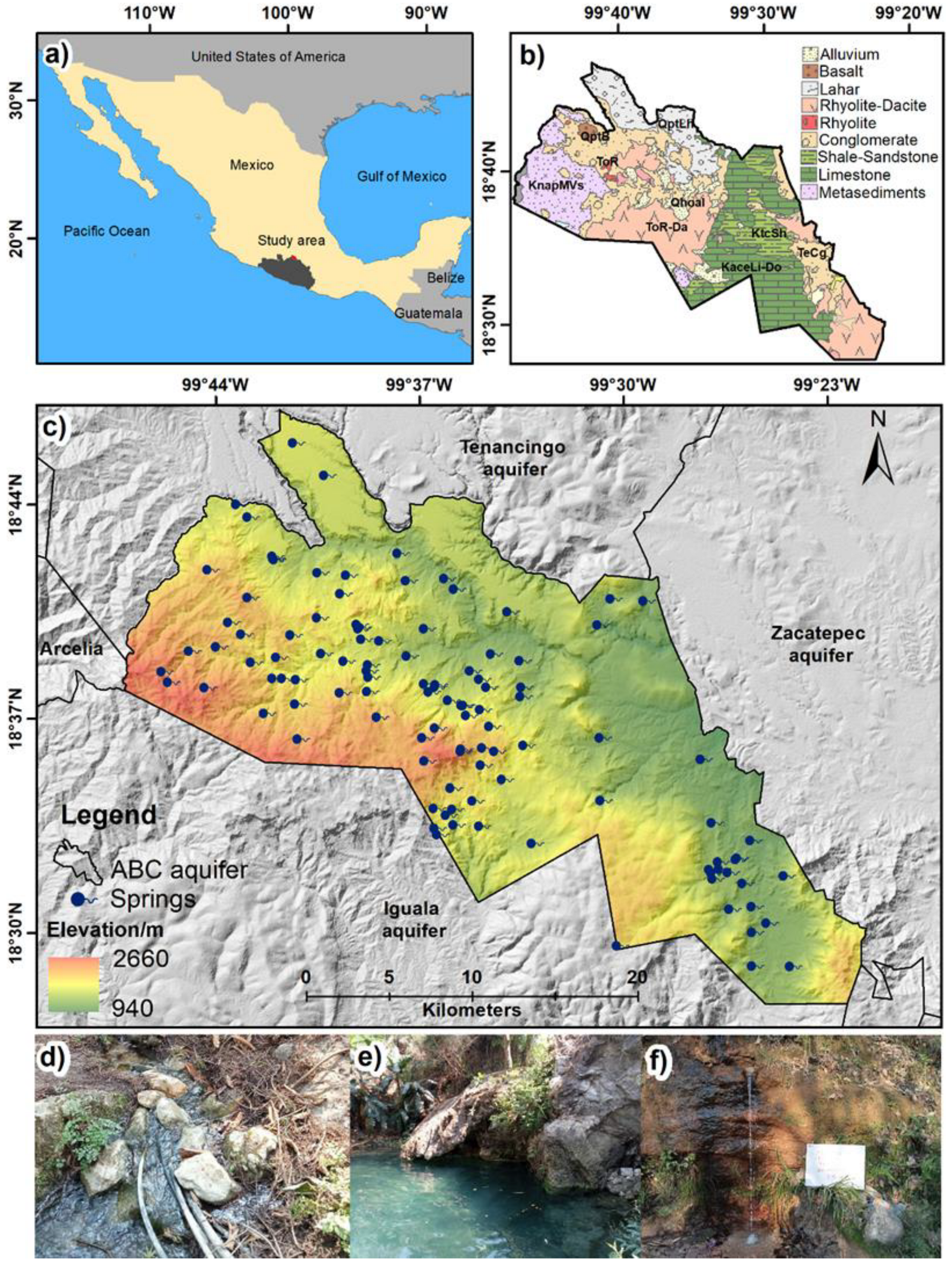
2.1. Study Area

The Buenavista de Cuellar Aquifer (ABC) is located in the Sierra Madre del Sur, covers an approximate area of 672 km2, and has approximately 39,287 inhabitants [43]. This aquifer limits to the north with the Tenancingo aquifer (State of Mexico), to the west with the Arcelia aquifer, to the east with the Zacatepec aquifer (State of Morelos), and to the south with the Iguala and Pololcingo aquifers (Figure 1). Four municipalities of the State of Guerrero are located within its limits; it fully comprises the municipality of Pilcaya and partially the municipalities of Tetipac, Taxco de Alarcón, and Buenavista de Cuéllar [21].
The aquifer presents three climate types: warm sub-humid with summer rains (A C(w1)) in the northern portion, semi-warm–humid with summer rains (A C(w2)) in the south and southwest, and warm sub-humid with summer rains (Awo) to the east [21]. The average annual precipitation value is 1044 mm, while potential evaporation varies around 1950 mm. Moreover, the relief presents high elevations (e.g., Cerro del Huixteco) and steep slopes unsuitable for storing surface runoff. The drainage pattern is of the dendritic type with a predominantly NE–SW direction, an intermittent regime, and only some streams with base flow [21].
The main lithological units that make up the aquifer include Jurassic and lower Cretaceous metamorphic rocks (schist, slate, and metavolcanic rocks), Cretaceous marine sedimentary rocks (limestones and sandstones) both shelf and basin, extrusive igneous rocks (tuffs and rhyolites) and intrusive Tertiary (granodiorite, granite, and diorite) and Tertiary (lahar and polymictic conglomerates)/Quaternary sedimentary deposits (alluvial and fluvial sediments of varied granulometry). The units are sometimes in contact through faults and thrusts, giving great structural complexity [21,44].
According to the hydrogeological context, the ABC is a heterogeneous and anisotropic-free aquifer whose geological formations present secondary permeability due to fracturing and also dissolution in the case of platform calcareous rocks. On the other hand, the marine sedimentary rocks of the Morelos and Mexcala formations may present confinement and semi-confinement conditions because they are overlain by shales and siltstones.
According to CONAGUA [21], 48 exploitations were registered: 43 springs, four dug wells, and one drilled well. The volume of extraction by pumping was negligible since the springs as a whole discharged a volume of 2.1 hm3/year, of which 2.06 hm3/year (98.1%) were destined for public-urban use and 0.04 hm3/year (1.9%) for domestic and livestock uses. Therefore, public-urban use is the most demanding consumer of groundwater. Currently, the most developed productive activities in the study area are agriculture (the main crops are white corn and beans) and livestock (cattle and pigs).
The methodology comprised four steps: (1) the preprocessing and preparation of the inputs (mapping), (2) the multi-criteria evaluation by using the AHP technique, (3) sample collection and water quality assessment, and (4) non-carcinogenic and fecal coliform health risk assessment (Figure 2).

2.2. Preprocessing and Preparation of the Inputs

The available cartographic information of the study area made it possible to identify the variables that can be considered to prioritize springs for analysis. The variables examined were the water uses [45], the geology [44], the land use/land cover changes [46], and the volume concessioned per spring [45], which were spatially represented on maps using GIS software.
The obtaining of variables and their importance for this research are described below:
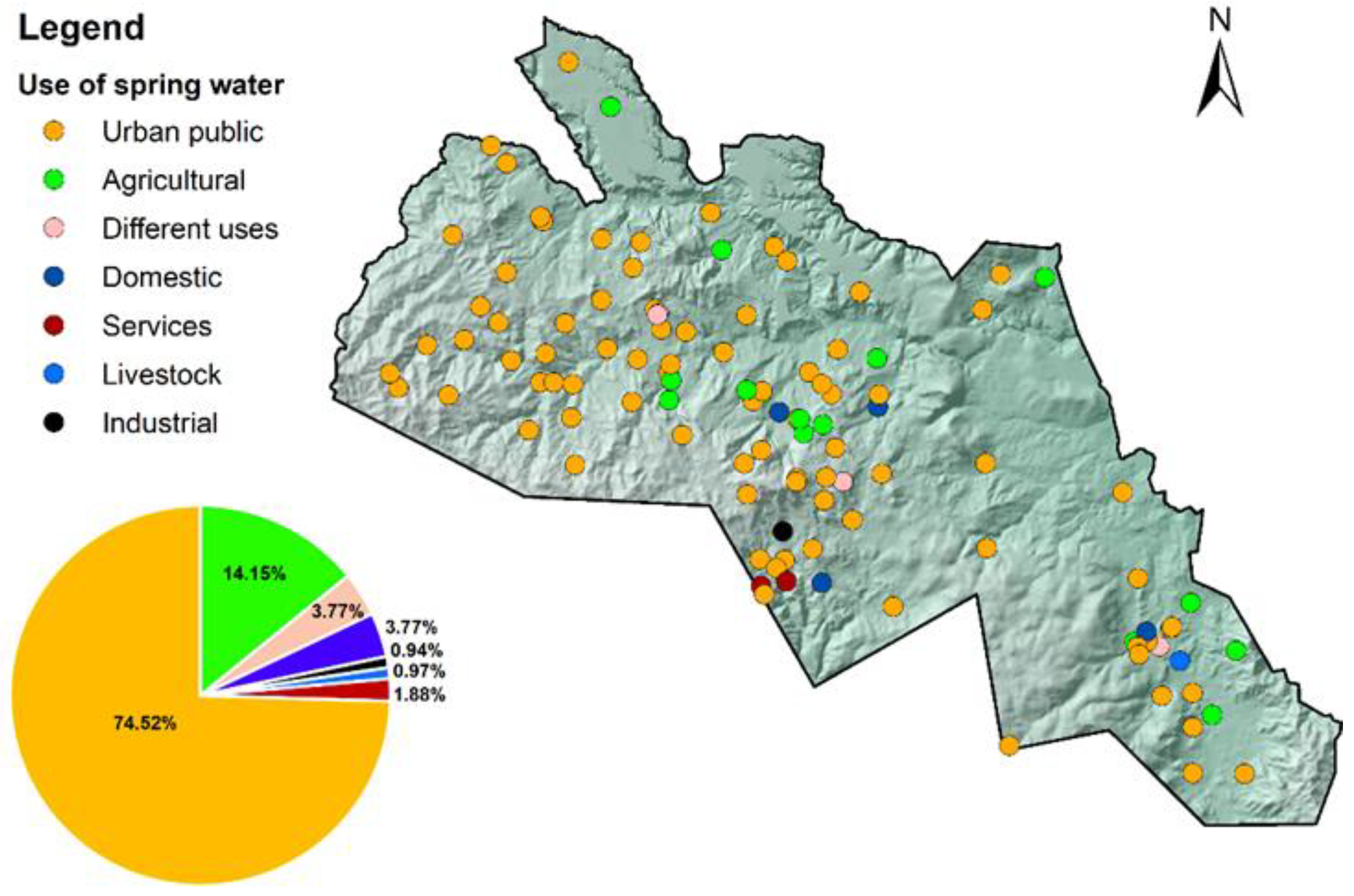
  • Water uses: it was obtained from the analysis of the REPDA database [45]. The map was elaborated in QGis, and it was classified into five use categories (domestic, urban public, agricultural, recreational, and other uses). Public urban and domestic uses are the most essential for the survival/health of the population and occupy the first place of use in the study area. These can change in relation to the increase or decrease of anthropogenic activities and population growth. The importance of including this variable is based on the impact on health generated by the various uses of water.
  • Geology: the mapping was obtained from SGM (2004) [44]. The importance of including this criterion was for the textural and structural conditions analysis of the rocks, such as porosity and permeability, with the objective of capturing an overview of the infiltration capacity of geological formations to incorporate pollutants in the emanation of the springs. Various lithologies were recognized, with limestone being the most relevant due to its high vulnerability [47].
  • Land use/land cover changes: the cartography of land use/vegetation cover [46] was prepared and classified into five categories, and they are agricultural land, urban area, pasture, forest, and shrubby vegetation. The objective of the mapping was to anticipate the deterioration that water sources may suffer due to pollution generated by agricultural (use of fertilizers and pesticides) and urban (wastewater discharge) areas, as well as to analyze its possible negative effect on human health [48].
  • Concessioned volume: the elaboration of the concessioned volume map was carried out based on consultation and analysis of the REPDA database [45]. It is important to analyze the springs with a greater concessioned volume, as the population’s health may be affected by the dermal or oral contact they have with the water.
  • Location of springs: the REPDA database was consulted and analyzed in the year 2022 [45]; it contains information on the 106 springs of the ABC with the permanent flow throughout the year and with concession titles. In addition, fieldwork included the participation of the municipal authorities and community personnel with the objective of identifying the exact location where the springs emanate, corroborating information, and visualizing the environment. The technical sheet proposed by CONAGUA [49,50] was also considered. This allowed us to gather information on the characteristics of the springs, such as an identifier (ID), name of the spring, UTM coordinates, municipality, use, concessioned volume (m3/year), title of concession/assignment, owner, and registration date. This database was used to develop the ABC spring location map and will serve as a conservation and protection strategy in future studies.

2.3. Multi-Criteria Evaluation (AHP Technique)

Once the inputs mentioned in the previous section were obtained, the multicriteria evaluation (MCE) was applied to select the springs with sampling priority. The MCE application was carried out in TerrSet, and the Analytical Hierarchy Process (AHP) was chosen. The steps of the method are described below.
Step 1. Establishing criteria: the selected criteria were classified into factors and restrictions. In this research, the factors were: the use of spring water, the use of land/coverage, the geology of the site where the spring emanates, and the volume under concession. No restrictions were considered.
Step 2. Normalization: first, quantitative factors (use of spring water, land use/land cover changes, and geology) were assigned a numerical value with a range from 1 to 5 (increasing scale), with 1 being the value with less importance and 5 representing the springs with greater relevance to be considered in the water quality sampling. The assignment of numerical values considered the original scale of each analyzed factor in order to obtain factors with a quantitative scale. This process was conducted for qualitative factors. Subsequently, the quantitative factors were normalized using a common scale (range from 0 to 255) so that they were comparable among themselves; the Fuzzy module of TerrSet, as well as the monotonically increasing function, were used in all the factors analyzed. This process was conducted according to the following equation [51,52].
Xi = Ri Rmin Rmax Rmin · SR
where Xi is the new value, standardized per pixel. Rmin means the minimum value of the factor per pixel. Rmax represents the maximum value of the factor per pixel. Ri denotes the value of the factor per pixel, and SR represents the maximum threshold of the range to be standardized (255).
Step 3. Weighing process (AHP technique): the process required a consultation with a panel of experts familiar with the research topic, including geographers, geologists, chemists, and hydrogeologists. The experts made a comparison of each factor to establish a hierarchy of relevance. To carry out this process, the AHP technique (numerical scale of values ranging from 1 to 9 based on the Saaty scale) was used by means of the TerrSet Weight module in order to make a comparison by pairs, obtain the weights of the factors, and denote their order of importance [53]; these are shown in Table 1. The AHP technique is one of the most applied in studies related to the management of water resources [38,39,54].
Additionally, the consistency ratio (CR) was calculated; the value must be <0.1 to be considered acceptable [53]. The CR was calculated as follows [53,55].
CR = CI RI
where CR refers to the consistency ratio. CI is the consistency index and RI indicates the random index, and the value depends on the number of factors used in the research (RI = 0.90 in this research) [55].
The consistency index is calculated with [56].
CI = λ   max n n 1
where ƛ is the principal eigenvalue of the matrix and n is the number of groundwater quality network factors.
Step 4. Evaluation (Weighted Linear Combination method (WLC)): the WLC (the most widely used method for evaluating multiple criteria) was applied. In this step, each factor is multiplied by its weight; the multi-criterial result was a suitability map with a byte scale (0 to 255). Moreover, the maximum value (255) of the suitability map was considered and divided into three categories of importance (low, medium, and high) in order to prepare the spring prioritization map. The categories come from guidelines suggested by the government body in charge of water management in Mexico, the National Commission of Water (CONAGUA). According to [51], the suitability (S) was calculated based on the following equation:
S = i = 1 n Wi   Xi
where S is the suitability, n is the number of factors, Wi represents the weight of factor i, and Xi is the value of factor i.
Subsequently, a spatial analysis of the high-priority spring distribution was conducted. Fieldwork enabled the evaluation of access routes to places where springs emanate since the terrains presented a rugged relief with difficult access. Furthermore, several sections of the study area are highly dangerous due to the control of criminal groups, so the springs located in those areas had to be discarded. These factors do not have cartographic representation and were not analyzed with MCE. Therefore, for this work, 20 springs distributed homogeneously in the aquifer were selected; the number was according to the economic resources available for the analysis of water quality.

2.4. Water Quality Assessment

2.4.1. Field Sampling and Data Analysis

Two spring water samples were conducted during the months of May and August 2022 (dry season and rainy season) in 20 springs, with the help of authorities from the communities. The measurement of parameters in situ was conducted using an OrionStar A329 multiparameter probe with a water temperature (T °C), total dissolved solids (TDS), and electrical conductivity (EC) electrode, as well as a second pH electrode (hydrogen potential). These were calibrated in the field with pre-established standards; the first electrode was calibrated with a standard solution (NaCl) of 1413 μS/cm, while the pH electrode was calibrated with buffer solutions of pH 4.0, 7.0 and 10.0 (at 25 °C).
The precision in the temperature reading of the equipment is ±0.5 °C, in electrical conductivity with ± 1% of the full scale (at 25 °C) and the pH of ±0.01 pH units. In addition, the total alkalinity was determined in the field by means of the sulfuric acid titration method and the methyl orange indicator; this was performed in duplicate, considering a blank and a control, for greater precision. The results were then multiplied by 1.22 to obtain the mg/L of calcium bicarbonate (HCO3).
The water samples were collected following the existing protocols, which are detailed in [57], as well as the procedures set forth in the standard NOM-230-SSA1-2002 [58], which follows the guidelines of the APHA-AWW-WEF [59]. Two water samples were collected from each spring and were filtered with a 0.45 μm nitrocellulose membrane, one for the analysis of anions and the other for the analysis of cations; the cation samples were preserved with nitric acid up to a pH less than or equal to 2. The major ions and trace elements were analyzed in the Environmental Geosciences Laboratory of UNAM. The samples for anions (Br, F, Cl, SO42, and NO3−) were analyzed by high-performance liquid chromatography (HPLC) with a Dionex ICS-1100 brand chromatograph. HPLC calibration curve was carried out with a standard certificate from Inorganic Ventures IF-FAS-1A, which consists of seven concentrations, and the drift control of the instrument was carried out by means of a laboratory control sample (MCL) prepared from the standard certificate seven anion standard of Dionex, which was analyzed every 10 samples.
The samples for cations (Ca2+, Mg2+, Na+, K+, Mn+, Ba+, Fe+, Zn+, Li+, Sr+, Ni+, Si+, Al+, and Cd+) were analyzed with the Perkin Elmer ICAP 6500 Duo Optical Emission Spectroscopy with inductively coupled plasma (ICP-OES) technique by using two calibration curves with six standards for the analysis (calibration greater than 0.9990), which were prepared from certified mono-element standards from the Inorganic Ventures brand and an ICP-200.7 multi-element standard from the High Purity Standards brand. The calibration blank and the reagent were analyzed, as well as three MCL, all made from certified standards with traceability to NIST; the recovery percentage was greater than 90%. In order to verify the validity of the analyzed data, the load balance of the majority of elements was carried out.
In addition, a third sample was collected for fecal coliform analysis using sterile containers. Subsequently, the samples were analyzed in a certified laboratory within the first 24 h of collection by using the NMX-AA-102-SCFI-2019 method [60], which is based on membrane filtration and culture in a chromogenic agar medium for coliforms. Culture media were incubated at 37 °C for 24 h. Afterward, the number of coliform microorganisms present in the sample was calculated and expressed in colony-forming units (CFU/100 mL) per 100 mL water sample.

2.4.2. Hydrogeochemistry

Piper diagrams to define the different hydrogeochemical groups were developed using Geochemist’s Workbench 11.0 software [61]. To obtain the quality of spring water, the results obtained were compared with the criteria for human use and consumption established in the WHO 2017 [62] and NOM-127-SSA1-2021 [63].

2.4.3. Statistical Analysis

Basic descriptive statistics were performed, obtaining minimum and maximum values, standard deviation, and measures of central tendency for each parameter evaluated. In addition, to compare whether there are significant differences between the results obtained from the two sampling periods, the T-student statistical analysis was performed in an Excel 2016 spreadsheet with a confidence level of 95%.

2.5. Health Risk Assessment

2.5.1. Non-Carcinogenic Health Risk

Water can affect human health through two exposure routes, the most common being through ingestion and dermal contact [29]. Therefore, the human health risk assessment model made it possible to determine the level of non-carcinogenic risk. The risk assessment parameters considered in this study were nitrates (NO3-), Potentially Toxic Elements (PTE) such as Ni, Cd, Zn, Fe, and Mn. The parameters evaluation is based on the concentrations detected in the spring water and their impact on human health.
The health risk associated with the chronic daily intake (CDI) of exposure to toxic elements (mg kg day-1) was calculated for adults and children, as established by the Integrated Risk Information System [64,65]. Ingestion rate and dermal absorption were calculated based on the US Environmental Protection Agency (USEPA) standards. The Ingestion CDI and the Dermal CDI were calculated using Equations (5) and (6) for both groups [65,66,67].
CDI ingestion - water = CW   IR EF ED B W + A T
CDI Dermal = CW   SA AF ABDS d ET ED CF BW + AT
where CW is the concentration of the element in the water, IR is the ingestion rate (L day−1), EF is the exposure frequency (days/year), ED refers to the exposure duration (years), BW indicates average body weight (kg), AT is the average time (days), SA is contact skin surface area (cm2), AF is skin adhesion factor, ABSd refers to skin absorption factor, CF corresponds to the conversion factor (kg mg−1), and ET is the exposure (h day−1) (Table 2).
Due to differences in physiology, assessment in adults and children, both by ingestion and by skin contact, was considered. Age 30 years for adults and 6 years for children was taken as a reference. Table 2 summarizes the values used for the calculation.
In addition, the hazard quotient (HQ) was evaluated for both the oral and dermal routes, according to the USEPA, Equations (7) and (8) [64].
HQingestion = CDI Ingestion RfD Ingestion
HQDermal = CDI Dermal RfD Dermal
where RfD denotes the reference dose (ingestion and dermal) based on the Environmental Protection Agency guidelines [64]. In the calculation of the health risk assessment, the RfD differs for each element, and the hazard index (HI) represents the cumulative non-carcinogenic risk index. The latter is the sum of the HQ values and is calculated with the following equation:
HI   = Σ HQi
where i is the HQ value of each element. In the context of human health, HI has a long-term harmful effect on health: Low risk (≥0.1<1), Medium risk (≥1<4), and High risk (>4) [69]. In the HI values, data were tested through the Shapiro–Wilk test to analyze the normality of the data set.

2.5.2. Human Health Risk Assessment Due to Fecal Coliforms

The health risk assessment due to fecal coliforms consists of the categorization of the results obtained with the risk scales established by the WHO. Table 3 presents the categories to classify this risk [70,71]. This assessment is relevant since people drink untreated water, and the consequence is suffering from gastrointestinal diseases.

3. Results and Discussion

3.1. Spring Location Map

The most outstanding result of the pre-processing and preparation was the ABC spring location map. This map presents the water uses classification based on REPDA data [47] and with the information provided by users. The ABC has a total of 106 springs distributed in the four municipalities that make it up, and the percentages are presented as follows: 74.52% are destined for public-urban use, 14.15% for agricultural use, 3.77% are occupied by two types of uses (domestic, recreational and ecotourism activities), and with values of 1.88%, 0.97%, and 0.94%, are the service, livestock, and industrial uses respectively (Figure 3). This information is attached as Supplementary Materials.

3.2. Multi-Criteria Evaluation (AHP Technique Results)

The consistency ratio (CR) was 0.08. The methodology used in the TerrSet software enabled prioritizing springs, a new contribution to the aquifer management framework. However, TerrSet is primarily used by the scientific community, which can be a limitation for government entities and the private sector. The result of having applied MCE was a suitability map classified into three priority categories: low, medium, and high. Springs in the low category occupy 6.6% and are located in the central portion of the aquifer, while those springs in the medium class occupy 14.2% and are distributed mainly in the municipalities of Tetipac and Buenavista de Cuéllar. On the other hand, springs in the high grade represent the highest percentage with 79.2% (related to the weight assigned to the water use factor 0.5943) and are distributed throughout the ABC (Figure 4). The analysis of the 79.2% of springs (high priority springs), access routes, and knowledge of the areas with high social insecurity risk enabled the selection of 20 springs to be sampled (Figure 5).
The 37% of springs have protection in place where they emanate (springs BC1, BC2, BC9, BC10, BC13, BC15, BC16, and BC17); however, protection is not conducted from the recharge area, which is a gap for future research. Likewise, the BC1, BC10, and BC16 springs have a network to distribute the vital liquid. In the rest of the springs, the water is taken directly from the places where they emanate.
Furthermore, in order to assess the water quality in space and time to preserve human health, it is also recommended to collect the necessary water samples to analyze major elements, trace elements, and microbiological. This is relevant in a water management program.

3.3. Hydrochemical Characteristics and Water Quality Assesment

The Piper diagram was developed for both samplings as a tool to obtain the main hydrogeochemical characteristics based on the relative dominance of the majority of ions in terms of their reaction values. In the springs analyzed, three predominant types of water were identified. During the May sampling, calcium bicarbonate water (BC1, BC2, BC3, BC4, BC5, BC6, BC7, BC8, BC9, BC10, BC11, BC12, BC14, BC15, BC16, BC17, BC19, and BC20) and sulfated bicarbonate (BC18 during the first sampling) were identified, while sodium bicarbonate was observed in the August sampling (BC13). The springs located in the highest zone of the study area show calcium and sodium enrichment due to the flow of groundwater through carbonate material of limestone from the Morelos formation. Some influence of sodium dissolution is the volcanic rocks of the Tilzapotla formation, while the sulfate enrichment is given by the influence of mineralization in the lower zones of the study area (Figure 6).
The water quality assessment was carried in 20 springs [62,63]. Spring water temperature was in the range of 16.8 to 28.1 °C, with an average of 22.81 °C. The pH ranged from 6.08 to 7.91, with an average of 6.9 in the dry season and an average of 6.7 in the rainy season, values that show it within the classification of “slightly acid to slightly alkaline” (Table 4). These values are mostly within the maximum permissible limits for human consumption in the Mexican standard and in the WHO criteria [62,63]. In general, pH refers to the force that the water has for reaction with acidic or alkaline material in itself [72]. The electrical conductivity (EC) indicates the material dissolved in the water, and its values varied between 40.86 and 1259 μS/cm (average of 465.67 μS/cm). While the TDS in the dry season had an average value of 230.81 mg/L, the values met the criteria established in [62,63]. On the other hand, the concentration of sulfate (SO42-) varied from 1.1 to 574.5 mg/L in the dry season, while in the rainy season, the range varied from 0.3 to 570.6 mg/L; likewise, the 5% of springs exceeded the limits of 400 mg/L (Mexican norm) and 250 mg/L established by the WHO in both seasons. Chlorides showed a minimum value of 1.20 mg/L and a maximum of 36.54 mg/L in the dry season; for the rainy season, the minimum value corresponded to 0.3 mg/L and a maximum of 39.5 mg/L. Therefore, they are within the recommendations of the World Health Organization 2017 (250 mg/L). In the case of nitrates, they play an important role in diseases such as methemoglobinemia; their presence is related to anthropogenic activities such as agriculture, wastewater discharges, leakage, and infiltration of urban drains [9,10]. The nitrate concentrations observed in the month of May varied between 0.56 and 26 mg/L (average of 5.62 mg/L), while for August, the values varied between 0.2 and 42.1 mg/L (7.9 mg/L on average). During the dry season, 10% of samples exceeded the maximum allowable limit by the official Mexican standard (11 mg/L). On the other side, during the rainy season, the number of springs that exceeded the maximum permissible limit increases (25% of springs).
Moreover, most of the samples collected in the study area presented detectable concentrations of Fe, Mn, Ni, F, Ba, Sr, B, Li, and Zn; however, almost all were below the maximum permissible limits in [62,63]. The 5% of springs exceeded the maximum allowed limit for iron established in the Mexican standard and WHO recommendations in both seasons (0.3 mg/L), while 5% of the springs presented cadmium in concentrations of 0.0125 mg/L, which is above the limits [65] and may pose a threat to human health; its presence is associated with impurities in the zinc of the galvanized pipes [73]. Finally, coliforms in the rainy season exceeded the permissible limits in 100% of the springs, while in the dry season, there is a high concentration in 85% of the springs (Table 4). This is worrying since it can cause severe gastrointestinal diseases.
The Student t-test showed significant differences (p < 0.05) between the means for the following parameters: NO3, Na+, Ni, and K+; therefore, it was identified that there was a significant increase during the sampling carried out in August (rainy season). The minimum, maximum, average, and standard deviation values of the evaluated parameters are shown in Table 4.

3.4. Human Health Risk Assessment

3.4.1. Non-Carcinogenic Health Risk

The non-carcinogenic human health risk was determined for adults (under 30 years) and children (under 6 years) by oral route and dermal contact (Table 5). The results of HI evaluated in adults and children by oral route indicate that there is a greater risk in children, while by dermal contact, the risk to health is greater in adults (Table 5). An exploratory analysis with Shapiro–Wilk’s method to test the normality was applied to the HI values. It was found that HI values through the oral route in children and adults followed a normal distribution, with R2 values equal to 0.9723 and 0.9238. The HI values through the dermal route showed a normal distribution, with R2 values equal to 0.9417 and 0.9459, respectively.
In general, the non-carcinogenic risk (HI) by oral route in children show that 60% of springs represent low risk, while 20% represent medium risk and 20 negligible. However, in adults, 50% of springs represent a low risk, while 25% represent medium risk and 25% are negligible. In both groups, there is no high risk to health by oral route (Figure 7a,b). Finally, the risk by dermal route presents a high risk for 10% of adults, a medium risk for 25%, a low risk for 50%, and negligible for 15%. While 5% of children present a medium risk, 60% low risk, and 35% negligible.

3.4.2. Human Health Risk Assessment Due to Fecal Coliforms

When assessing the human health risk due to fecal coliforms according to the criteria established by the World Health Organization [71], the results indicate that most of the springs present a condition of medium to high risk (Figure 8). In the dry season, 65% of springs have moderate risk, 15% present high risk, 5% very high risk, and 15% no risk. In the rainy season, a moderate risk was observed in 20% of springs, high risk in 55%, and low risk in 25%.
Water pollution by fecal coliforms can cause mortality and morbidities (e.g., typhoid fever, cholera, diarrhea, and hepatitis) [70,74]. To avoid negative effects, the water must receive some type of treatment before it is used as a supply source.
Finally, the results of the research in the short term may be made known through the implementation of workshops, with the participation of researchers, the community, and local authorities. It is important to mention that quality data information has been shared with local authorities; however, it is currently necessary to present the results and propose mitigation measures to have a better-quality resource and avoid water diseases. On the other hand, if mitigation measures are not proposed, or springs stay unprotected, the long-term consequences will be water quality deterioration and a greater number of diseases in the study area.

4. Conclusions

In the study area, samples of spring water were taken, and in situ parameters such as fecal coliforms, major ions, and Potentially Toxic Elements were analyzed. The health risk was evaluated for children and adults in relation to the oral and dermal routes. The main conclusions are as follows:
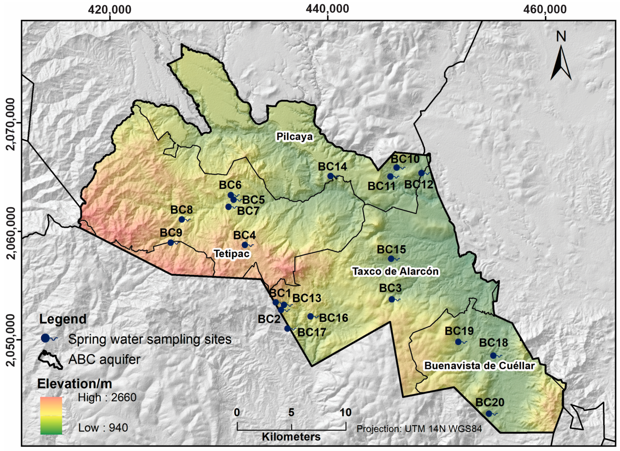
  • The AHP technique was a useful tool for identifying priority springs. This technique was applied by means of the Terrset software; however, Terrset is primarily used by the scientific community, which can be a limitation for government entities and the private sector. A total of 6.6% of springs are in the category of low priority, 14.2% in the medium category, and 79.2% in the high category. These percentages are strongly related to the weight assigned to the spring water use factor (relative weight 0.5943). The analysis of the 79.2% of springs with high priority, in relation to access routes as well as the dangerous zones due to crime, resulting in the selection of 20 springs distributed homogeneously in the ABC in order to optimize economic resources in the quality analysis. These springs could be considered by CONAGUA (commission in charge of water resources management in Mexico) to propose a quality monitoring network at the aquifer level.
  • Spring water is slightly alkaline, with TDS ranging from 20.52 to 230.5 (dry season) and 1.2 to 257 mg/L (rainy season). In relation to the normative standards of water for human consumption [62,63], the springs exceeded the maximum permissible limits by 100% for fecal coliforms, 25% for nitrates, 5% for sulfates, 5% for iron, and 5% for cadmium.
  • Polluted water represents a risk to human health due to water ingestion and/or dermal exposure. There is a higher non-carcinogenic risk by the oral route in children (with an average HI value of 0.6371) and a higher risk by the dermal route in adults (with an average HI value of 1.2378). The highest dermal risks are located in the south-southeast of the study area. However, the approaches used in this study contain some potential uncertainties. The RfD obtained from the USEPA could not be specific for Latin America; in addition, the application of the average concentration of each element to assess the level of risk to health in the inhabitants of the place was based on a point sampling of the sites.
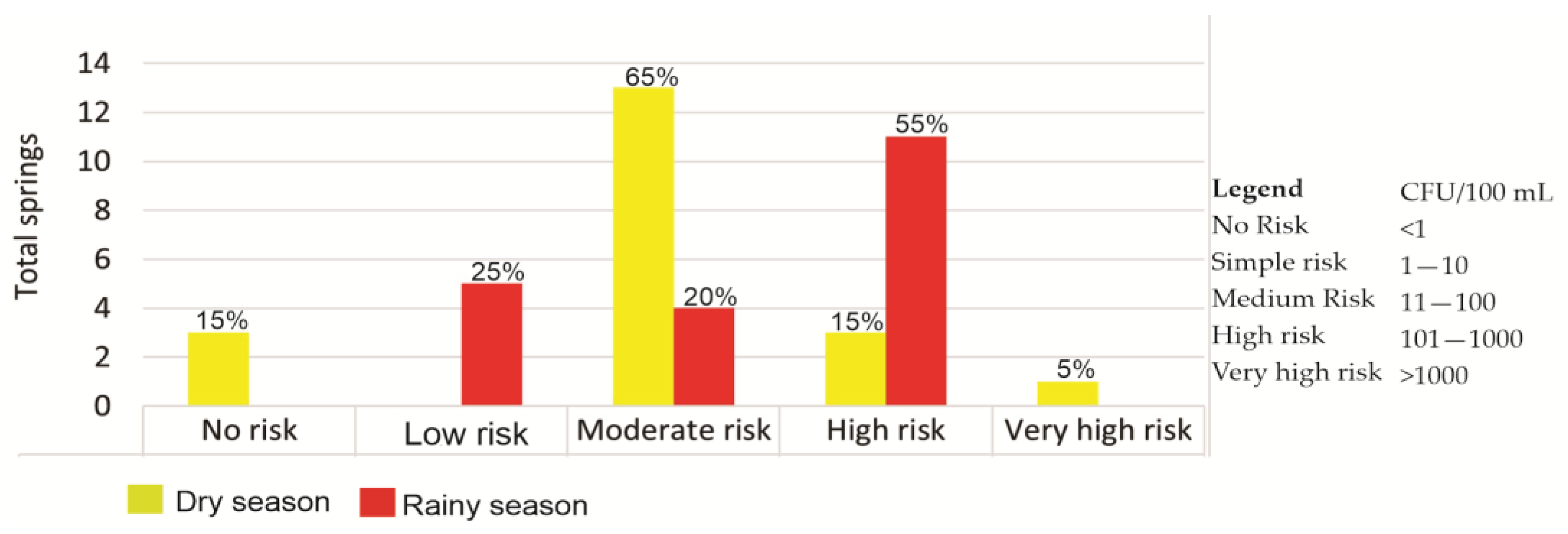
  • The human health risk from fecal coliforms was medium in the dry season and high in the rainy season. The recommendations are based on the following: in situ treatment such as boiling or chlorination of the water would be the most cost-effective actions to overcome the problem, intensification of the monitoring quality capacity, inventory/relocate pollution sources that are upstream of the springs and protect the places where the springs emanate in order to avoid gastrointestinal diseases. Finally, the results of this research will serve to improve groundwater management while optimizing the economic resources invested in the ABC water quality sampling. This methodology can also be applied to other aquifers in the country by the authorities in charge, CONAGUA in Mexico.

Supplementary Materials

The following supporting information can be downloaded at: https://www.mdpi.com/article/10.3390/w15101863/s1. Springs location in the ABC (table name: Inventory_Springs) and tables: in situ parameters, fecal coliforms, majority ions and PTE during the dry and rainy season (May and August 2022).

Author Contributions

M.A.C.C.—sampling collection, data curation, data analysis, map editing, geochemical assessment, and paper writing-editing; J.M.E.M.—sampling collection, data analysis, maps editing, writing—review and editing, and supervision; E.R.S.S.—sampling collection, data analysis, geochemical assessment, writing—review and editing, and supervision; C.Á.B.—data analysis, geochemical assessment, and writing review; J.G.P.S.—writing—review; M.E.L.M.—writing—review; Ó.T.M.—writing—review and editing. All authors have read and agreed to the published version of the manuscript.

Funding

This research received no external funding.

Data Availability Statement

All processed data used in the study have been shown in the article. Raw data may be available on request from the corresponding author.

Acknowledgments

This work was conducted with the support of a grant provided by the Consejo Nacional de Ciencia y Tecnología (CONACYT). We would like to express our gratitude to the staff of the Environmental Geochemistry Laboratory, UNAM, municipal authorities, and the researchers at the Autonomous University of Guerrero for their comments and suggestions. Finally, the authors are grateful to the unknown reviewers and editors for their comments and suggestions for the improvement of the article.

Conflicts of Interest

The authors declare no conflict of interest.

References

  1. Leite, N.K.; Stolberg, J.; da Cruz, S.P.; Tavela, A.D.O.; Safanelli, J.L.; Marchini, H.R.; Exterkoetter, R.; Leite, G.M.C.; Krusche, A.V.; Johnson, M.S. Hydrochemistry of Shallow Groundwater and Springs Used for Potable Supply in Southern Brazil. Environ. Earth Sci. 2018, 77, 80. [Google Scholar] [CrossRef]
  2. Pande, C.B.; Moharir, K.N.; Singh, S.K.; Elbeltagi, A.; Pham, Q.B.; Panneerselvam, B.; Panneerselvam, B.; Varade, A.M.; Kouadri, S. Groundwater flow modeling in the basaltic hard rock area of Maharashtra, India. Appl. Water Sci. 2022, 12, 12. [Google Scholar] [CrossRef]
  3. Yaghobi, S.; Faramarzi, M.; Karimi, H.; Sarvarian, J. Simulation of Land-Use Changes in Relation to Changes of Groundwater Level in Arid Rangeland in Western Iran. Int. J. Environ. Sci. Technol. 2019, 16, 1637–1648. [Google Scholar] [CrossRef]
  4. Moldovan, A.; Hoaghia, M.-A.; Kovacs, E.; Mirea, I.C.; Kenesz, M.; Arghir, R.A.; Petculescu, A.; Levei, E.A.; Moldovan, O.T. Quality and Health Risk Assessment Associated with Water Consumption—A Case Study on Karstic Springs. Water 2020, 12, 3510. [Google Scholar] [CrossRef]
  5. Aher, S.; Deshmukh, K.; Gawali, P.; Zolekar, R.; Deshmukh, P. Hydrogeochemical Characteristics and Groundwater Quality Investigation along the Basinal Cross-Section of Pravara River, Maharashtra, India. J. Asian Earth Sci. X 2022, 7, 100082. [Google Scholar] [CrossRef]
  6. Davraz, A.; Batur, B. Hydrogeochemistry Characteristics of Groundwater and Health Risk Assessment in Yalvaç–Gelendost Basin (Turkey). Appl. Water Sci. 2021, 11, 67. [Google Scholar] [CrossRef]
  7. WHO. Guidelines on Sanitation and Health; World Health Organization: Geneva, Switzerland, 2018.
  8. El Mountassir, O.; Bahir, M.; Ouazar, D.; Chehbouni, A.; Carreira, P.M. Temporal and Spatial Assessment of Groundwater Contamination with Nitrate Using Nitrate Pollution Index (NPI), Groundwater Pollution Index (GPI), and GIS (Case Study: Essaouira Basin, Morocco). Environ. Sci. Pollut. Res. Int. 2022, 29, 17132–17149. [Google Scholar] [CrossRef]
  9. Ather, D.; Muhammad, S.; Ali, W. Fluoride and Nitrate Contaminations of Groundwater and Potential Health Risks Assessment in the Khyber District, North-Western Pakistan. Int. J. Environ. Anal. Chem. 2022, 1–16. [Google Scholar] [CrossRef]
  10. Yu, G.; Wang, J.; Liu, L.; Li, Y.; Zhang, Y.; Wang, S. The Analysis of Groundwater Nitrate Pollution and Health Risk Assessment in Rural Areas of Yantai, China. BMC Public Health 2020, 20, 437. [Google Scholar] [CrossRef]
  11. Wakejo, W.K.; Meshesha, B.T.; Habtu, N.G.; Mekonnen, Y.G. Anthropogenic Nitrate Contamination of Water Resources in Ethiopia: An Overview. Water Sci. Technol. Water Supply 2022, 22, 8157–8172. [Google Scholar] [CrossRef]
  12. Banowati, L.; Aeni, H.F.; Herawati, C. Relationship between Bacteriological Quality of Drilled Well Water and the Incidence of Diarrhea among Families. J. Phys. Conf. Ser. 2020, 1477, 062023. [Google Scholar] [CrossRef]
  13. Gizachew, M.; Admasie, A.; Wegi, C.; Assefa, E. Bacteriological Contamination of Drinking Water Supply from Protected Water Sources to Point of Use and Water Handling Practices among Beneficiary Households of Boloso Sore Woreda, Wolaita Zone, Ethiopia. Int. J. Microbiol. 2020, 2020, 5340202. [Google Scholar] [CrossRef]
  14. Chauhan, J.S.; Badwal, T.; Badola, N. Assessment of Potability of Spring Water and Its Health Implication in a Hilly Village of Uttarakhand, India. Appl. Water Sci. 2020, 10, 73. [Google Scholar] [CrossRef]
  15. Wagh, V.M.; Panaskar, D.B.; Mukate, S.V.; Aamalawar, M.L.; Laxman Sahu, U. Nitrate associated health risks from groundwater of Kadava River Basin Nashik, Maharashtra, India. Hum. Ecol. Risk Assess. Int. J. 2020, 26, 654–672. [Google Scholar] [CrossRef]
  16. Chen, F.; Yao, L.; Mei, G.; Shang, Y.; Xiong, F.; Ding, Z. Groundwater Quality and Potential Human Health Risk Assessment for Drinking and Irrigation Purposes: A Case Study in the Semiarid Region of North China. Water 2021, 13, 783. [Google Scholar] [CrossRef]
  17. Dhaliwal, S.S.; Singh, J.; Taneja, P.K.; Mandal, A. Remediation techniques for removal of heavy metals from the soil contami-nated through different sources: A review. Environ. Sci. Pollut. Res. 2020, 27, 1319–1333. [Google Scholar] [CrossRef]
  18. He, X.; Li, P.; Ji, Y.; Wang, Y.; Su, Z.; Elumalai, V. Groundwater Arsenic and Fluoride and Associated Arsenicosis and Fluorosis in China: Occurrence, Distribution and Management. Expo. Health 2020, 12, 355–368. [Google Scholar] [CrossRef]
  19. Sheikhi, S.; Faraji, Z.; Aslani, H. Arsenic health risk assessment and the evaluation of groundwater quality using GWQI and multivariate statistical analysis in rural areas, Hashtroud, Iran. Environ. Sci. Pollut. Res. 2021, 28, 3617–3631. [Google Scholar] [CrossRef]
  20. Papazotos, P. Potentially toxic elements in groundwater: A hotspot research topic in environmental science and pollution re-search. Environ. Sci. Pollut. Res. 2021, 28, 47825–47837. [Google Scholar] [CrossRef]
  21. CONAGUA. Actualización de la Disponibilidad Media Anual de Agua en el Acuífero Buenavista de Cuéllar Estado de Guerrero. México: Comisión Nacional del Agua. DOF, Diciembre de 2020. Available online: https://sigagis.conagua.gob.mx/gas1/Edos_Acuiferos_18/guerrero/DR_1204.pdf (accessed on 23 November 2021).
  22. Salcedo Sánchez, E.R.; Martínez, J.M.E.; Morales, M.M.; Talavera Mendoza, O.; Alberich, M.V.E. Ecological and Health Risk Assessment of Potential Toxic Elements from a Mining Area (Water and Sediments): The San Juan-Taxco River System, Guerrero, Mexico. Water 2022, 14, 518. [Google Scholar] [CrossRef]
  23. Flores Ronces, A. Isótopos de Estroncio Como Trazadores de Interacción Agua-Roca en la Región Minera de Taxco, Guerrero. Master’s Thesis, Universidad Autónoma de Guerrero, Acapulco de Juárez, Mexico, 2019. [Google Scholar]
  24. Arroyo-Díaz, F.; Salgado-Souto, S.A.; Del Rio-Salas, R.; Talavera-Mendoza, O.; Ramírez-Guzmán, A.; Ruíz, J.; Sarmiento-Villagrana, A.; Guzmán-Martínez, M. PTE and Multi-Isotope Assessment of Spring Water Used for Human Consumption in the Historical Mining Region of Taxco de Alarcón in Southern Mexico. J. S. Am. Earth Sci. 2022, 116, 103811. [Google Scholar] [CrossRef]
  25. Gad, M.; Gaagai, A.; Eid, M.H.; Szűcs, P.; Hussein, H.; Elsherbiny, O.; Elsayed, S.; Khalifa, M.M.; Moghanm, F.S.; Moustapha, M.E.; et al. Groundwater Quality and Health Risk Assessment Using Indexing Approaches, Multivariate Statistical Analysis, Artificial Neural Networks, and GIS Techniques in El Kharga Oasis, Egypt. Water 2023, 15, 1216. [Google Scholar] [CrossRef]
  26. Adimalla, N. Spatial Distribution, Exposure, and Potential Health Risk Assessment from Nitrate in Drinking Water from Semi-Arid Region of South India. Hum. Ecol. Risk Assess 2020, 26, 310–334. [Google Scholar] [CrossRef]
  27. Zhao, Z.; Zhou, Y.; Wang, X.; Wang, Z.; Bai, Y. Water Quality Evolution Mechanism Modeling and Health Risk Assessment Based on Stochastic Hybrid Dynamic Systems. Expert Syst. Appl. 2022, 193, 116404. [Google Scholar] [CrossRef]
  28. Bodrud-Doza, M.; Islam, S.M.D.-U.; Rume, T.; Quraishi, S.B.; Rahman, M.S.; Bhuiyan, M.A.H. Groundwater Quality and Human Health Risk Assessment for Safe and Sustainable Water Supply of Dhaka City Dwellers in Bangladesh. Groundw. Sustain. Dev. 2020, 10, 100374. [Google Scholar] [CrossRef]
  29. Li, J.; Sun, C.; Chen, W.; Zhang, Q.; Zhou, S.; Lin, R.; Wang, Y. Groundwater Quality and Associated Human Health Risk in a Typical Basin of the Eastern Chinese Loess Plateau. Water 2022, 14, 1371. [Google Scholar] [CrossRef]
  30. Wang, M.; Zhang, W.; Yang, P.; Feng, J.; Zhang, R.; Gao, Z.; Jin, H.; Song, X.; Gao, X. Hydrogeochemical Characteristics, Water Quality, and Human Health Risks of Groundwater in Wulian, North China. Water 2023, 15, 359. [Google Scholar] [CrossRef]
  31. Mandindi, W.Z.; Nyaba, L.; Mketo, N.; Nomngongo, P.N. Seasonal Variation of Drinking Water Quality and Human Health Risk Assessment: A Case Study in Rural Village of the Eastern Cape, South Africa. Water 2022, 14, 2013. [Google Scholar] [CrossRef]
  32. Ramos, E.; Bux, R.K.; Medina, D.I.; Barrios-Piña, H.; Mahlknecht, J. Spatial and Multivariate Statistical Analyses of Human Health Risk Associated with the Consumption of Heavy Metals in Groundwater of Monterrey Metropolitan Area, Mexico. Water 2023, 15, 1243. [Google Scholar] [CrossRef]
  33. Chaudhry, A.K.; Sachdeva, P. Groundwater Quality and Non-Carcinogenic Health Risk Assessment of Nitrate in the Semi-Arid Region of Punjab, India. J. Water Health 2020, 18, 1073–1083. [Google Scholar] [CrossRef] [PubMed]
  34. Malakootian, M.; Mohammadi, A.; Faraji, M. Investigation of Physicochemical Parameters in Drinking Water Resources and Health Risk Assessment: A Case Study in NW Iran. Environ. Earth Sci. 2020, 79, 195. [Google Scholar] [CrossRef]
  35. Shukla, S.; Saxena, A. Groundwater Quality and Associated Human Health Risk Assessment in Parts of Raebareli District, Uttar Pradesh, India. Groundw. Sustain. Dev. 2020, 10, 100366. [Google Scholar] [CrossRef]
  36. Alamerew, Y.A.; Kambanou, M.L.; Sakao, T.; Brissaud, D. A Multi-Criteria Evaluation Method of Product-Level Circularity Strategies. Sustainability 2020, 12, 5129. [Google Scholar] [CrossRef]
  37. Valente, R.A.; de Mello, K.; Metedieri, J.F.; Américo, C. A Multicriteria Evaluation Approach to Set Forest Restoration Priorities Based on Water Ecosystem Services. J. Environ. Manag. 2021, 285, 112049. [Google Scholar] [CrossRef]
  38. Taheri, K.; Missimer, T.M.; Amini, V.; Bahrami, J.; Omidipour, R. A GIS-Expert-Based Approach for Groundwater Quality Monitoring Network Design in an Alluvial Aquifer: A Case Study and a Practical Guide. Environ. Monit. Assess 2020, 192, 684. [Google Scholar] [CrossRef]
  39. Esquivel-Martínez, J.M.; Expósito-Castillo, J.L.; Esteller-Alberich, M.V.; Gómez-Albores, M.A.; Medina-Rivas, C.M.; Fonseca-Ortiz, C.R. Prioritization of Areas for Groundwater Monitoring Using Analytic Hierarchy Process Method in Geographic Information Systems: A Case of Mexico. Int. J. Environ. Sci. Technol. 2022. [CrossRef]
  40. Mega, N.; Khechana, S. Groundwater Quality Assessment by Analytic Hierarchy Process (Geographic Information Systems-Based Model) in Souf Region (South-East of Algeria). Int. J. Environ. Sci. Technol. 2021, 18, 3459–3468. [Google Scholar] [CrossRef]
  41. Saaty, T.L. How to Make a Decision: The Analytic Hierarchy Process. Eur. J. Oper. Res. 1990, 48, 9–26. [Google Scholar] [CrossRef]
  42. Saranya, T.; Saravanan, S. Assessment of Groundwater Vulnerability Using Analytical Hierarchy Process and Evidential Belief Function with DRASTIC Parameters, Cuddalore, India. Int. J. Environ. Sci. Technol. 2023, 20, 1837–1856. [Google Scholar] [CrossRef]
  43. INEGI. Censo de Población y Vivienda 2020. Instituto Nacional de Estadística y Geografía (INEGI). 2020. Available online: https://inegi.org.mx/programas/ccpv/2020/#Micro (accessed on 23 March 2023).
  44. SGM. Edición de Cartas Geológicas y Geoquímicas Escala 1:50,000. Servicio Geológico Mexicano. 2004. Available online: http://www.sgm.gob.mx/cartas/Cartas_Ed50.jsp (accessed on 19 December 2021).
  45. CONAGUA. Base de datos del Registro Público de Derechos del Agua (REPDA). 2022. Available online: https://app.conagua.gob.mx/consultarepda.aspx (accessed on 10 December 2021).
  46. INEGI. Usos del Suelo y Vegetación. Instituto Nacional de Estadística y Geografía (INEGI). 2018. Available online: https://www.inegi.org.mx/temas/usosuelo/ (accessed on 23 March 2022).
  47. Martínez-Salvador, C.; Moreno-Gómez, M.; Liedl, R. Estimating Pollutant Residence Time and NO3 Concentrations in the Yucatan Karst Aquifer; Considerations for an Integrated Karst Aquifer Vulnerability Methodology. Water 2019, 11, 1431. [Google Scholar] [CrossRef]
  48. Foster, S.; Hirata, R.; Gomes, D.; D’Elia, M.; Paris, M. Protección de la calidad del agua subterránea. In Guía Para Empresas de Agua, Autoridades Municipales y Agencias Ambientales, 2nd ed.; Banco Mundial: Washington, DC, USA, 2007; pp. 17–69. [Google Scholar]
  49. Lopez Valle, S. Estrategias Para la Protección de Manantiales: Propuesta Metodológica de Acuerdo al Entorno Físico-Social y Proyección de Escenarios. Ph.D. Thesis, Universidad Autónoma del Estado de México, Toluca, Mexico, 2018. [Google Scholar]
  50. Silva García, J.T.; Ochoa Estrada, S.; Cruz Cárdenas, G.; Nava Velázquez, J.; Villalpando Barragán, F. Manantiales de la cuenca del río Duero Michoacán: Operación, calidad y cantidad. Rev. Int. Contam. Ambient. 2016, 32, 55–68. [Google Scholar]
  51. Eastman, J.R. IDRISI TerrSet. In Geospatial Monitoring and Modeling System; Clark Labs: Worcester, MA, USA, 2016. [Google Scholar]
  52. Drobne, S.; Lisec, A. Multi-attribute Decision Analysis in GIS: Weighted Linear Combination and ordered weighted averaging. Informatica 2009, 33, 459–474. [Google Scholar]
  53. Saaty, T.L. Relative Measurement and Its Generalization in Decision Making Why Pairwise Comparisons Are Central in Mathematics for the Measurement of Intangible Factors the Analytic Hierarchy/Network Process. Rev. R. Acad. Cienc. Exactas Fis. Nat. Ser. A Mat. RACSAM 2008, 102, 251–318. [Google Scholar] [CrossRef]
  54. Hajkowicz, S.; Collins, K. A Review of Multiple Criteria Analysis for Water Resource Planning and Management. Water Resour. Manag. 2007, 21, 1553–1566. [Google Scholar] [CrossRef]
  55. Yavuz Kumlu, K.B.; Tüdeş, Ş. Determination of Earthquake-Risky Areas in Yalova City Center (Marmara Region, Turkey) Using GIS-Based Multicriteria Decision-Making Techniques (Analytical Hierarchy Process and Technique for Order Preference by Similarity to Ideal Solution). Nat. Hazards 2019, 96, 999–1018. [Google Scholar] [CrossRef]
  56. Bagdanavičiūtė, I.; Valiūnas, J. GIS-Based Land Suitability Analysis Integrating Multi-Criteria Evaluation for the Allocation of Potential Pollution Sources. Environ. Earth Sci. 2013, 68, 1797–1812. [Google Scholar] [CrossRef]
  57. Boulding, J.R. Practical Handbook of Soil, Vadose Zone, and Ground-Water Contamination Assessment, Prevention and Remediation; Lewis Pub: Boca Raton, FL, USA, 1995. [Google Scholar]
  58. DOF. PROYECTO de Norma Oficial Mexicana PROY-NOM-230-SSA1-2002, Salud Ambiental. Diario Oficial de la Federación. 2003. Available online: https://www.dof.gob.mx/nota_detalle.php?codigo=691563&fecha=01/08/2003 (accessed on 18 March 2022).
  59. APHA; AWWA; WEF. Standard Methods for the Examination Water and Wastewater, 21st ed.; APHA; AWWA; WEF: Washington, DC, USA, 2005. [Google Scholar]
  60. DOF. Declaratoria de Vigencia de la Norma Mexicana NMX-AA-102-SCFI-2019. Calidad del Agua-Enumeración de Escherichia coli y Bacterias Coliformes-Método de Filtración por Membrana. Diario Oficial de la Federación. 2020. Available online: https://www.dof.gob.mx/nota_detalle.php?codigo=5596379&fecha=08/07/2020#gsc.tab=0 (accessed on 20 April 2022).
  61. Aqueous Solutions LCC. The Geochemist’s Workbench; Versión 11; Software; Department of Geology at the University of Illinois Urbana Champaign: Champaign, IL, USA, 2016; Available online: https://www.gwb.com/ (accessed on 15 December 2022).
  62. WHO. Guidelines for Drinking-Water Quality, 4th ed.; Incorporating 1st and 2nd Addenda; WHO: Geneva, Switzerland, 2017; Volume 1.
  63. DOF. Norma Oficial Mexicana NOM-127-SSA1-2021, Agua Para Uso y Consumo Humano. Límites Permisibles de la Calidad del Agua. Diario Oficial de la Federación. 2022. Available online: https://www.dof.gob.mx/nota_detalle.php?codigo=5650705&fecha=02/05/2022 (accessed on 15 April 2022).
  64. USEPA. Guidelines for Carcinogen Risk Assessment; EPA/630/P-03/001F; Risk Assessment Forum: Washington, DC, USA, 2005. [Google Scholar]
  65. USEPA. Exposure Factors Handbook; EPA/600/R-09/052F; National Center for Environmental Assessment: Washington, DC, USA, 2011. Available online: http://www.epa.gov/ncea/efh (accessed on 15 October 2021).
  66. EPA. Regional Screening Levels (RSLs), Risk Assessment, 2013; US EPA: Washington, DC, USA, 2013.
  67. Prasad, S.; Saluja, R.; Joshi, V.; Garg, J.K. Heavy metal pollution in surface water of the Upper Ganga River, India: Human health risk assessment. Environ. Monit. Assess 2020, 192, 742. [Google Scholar] [CrossRef]
  68. Kan, X.; Dong, Y.; Feng, L.; Zhou, M.; Hou, H. Contamination and Health Risk Assessment of Heavy Metals in China’s Lead-Zinc Mine Tailings: A Meta-Analysis. Chemosphere 2021, 267, 128909. [Google Scholar] [CrossRef]
  69. USEPA. Human health evaluation manual (Part A). In Risk Assessment Guidance for Superfund; Ofce of Emergency and Remedial Response, US Environmental Protection Agency: Washington, DC, USA, 1989; Volume 1. [Google Scholar]
  70. Daghara, A.; Al-Khatib, I.A.; Al-Jabari, M. Quality of Drinking Water from Springs in Palestine: West Bank as a Case Study. J. Environ. Public Health 2019, 2019, 8631732. [Google Scholar] [CrossRef]
  71. World Health Organization. Guidelines for Drinking-Water Quality; World Health Organization: Geneva, Switzerland, 2004.
  72. Ahmed, N.; Bodrud-Doza, M.; Islam, S.M.D.-U.; Choudhry, M.A.; Muhib, M.I.; Zahid, A.; Hossain, S.; Moniruzzaman, M.; Deb, N.; Bhuiyan, M.A.Q. Hydrogeochemical Evaluation and Statistical Analysis of Groundwater of Sylhet, North-Eastern Bangladesh. Acta Geochim. 2019, 38, 440–455. [Google Scholar] [CrossRef]
  73. Qasemi, M.; Shams, M.; Sajjadi, S.A.; Farhang, M.; Erfanpoor, S.; Yousefi, M.; Zarei, A.; Afsharnia, M. Cadmium in Groundwater Consumed in the Rural Areas of Gonabad and Bajestan, Iran: Occurrence and Health Risk Assessment. Biol. Trace Elem. Res. 2019, 192, 106–115. [Google Scholar] [CrossRef] [PubMed]
  74. Kapembo, M.L.; Mukeba, F.B.; Sivalingam, P.; Mukoko, J.B.; Bokolo, M.K.; Mulaji, C.K.; Mpiana, P.T.; Poté, J.W. Survey of Water Supply and Assessment of Groundwater Quality in the Suburban Communes of Selembao and Kimbanseke, Kinshasa in Democratic Republic of the Congo. Sustain. Water Resour. Manag. 2022, 8, 3. [Google Scholar]
Figure 1. (a) Mexican republic, (b) Geological map of the aquifer, (c) Buenavista de Cuéllar aquifer, (d) Spring for human consumption, (e) Spring for recreational purposes, and (f) Spring for domestic use.
Water 15 01863 g001
Figure 2. Methodological scheme.
Water 15 01863 g002
Figure 3. Uses of spring water in the ABC. Classification and distribution.
Water 15 01863 g003
Figure 4. Spring prioritization map of ABC.
Water 15 01863 g004
Figure 5. Spring water sampling sites map.
Water 15 01863 g005
Figure 6. Spring water classification. Analysis of two sampling periods.
Water 15 01863 g006
Figure 7. Risk index (HI value) (a) through oral route in adults 2022, (b) through oral route in children 2022, (c) through dermal route in adults 2022, and (d) through dermal route in children 2022.
Water 15 01863 g007
Figure 8. Percentage of risk to human health from fecal coliforms.
Water 15 01863 g008
Table 1. Values of the weighting coefficient of each factor and corresponding weights.
FactorsGeologyWater UseLand UseVolumeWeights
Geology1 0.1136
Water use71 0.5943
Land use31/31 0.2532
Volume1/51/91/710.0390
Table 2. Exposure factors used in the estimation of chronic daily intake (CDI) for non-carcinogenic risk.
SymbolNameUnitRecommended Value
CwElement concentrationmg L−1
IRIngestion rateL día−1Adult 2.5
Child 0.80
EFExposure frequencyday y−1350
EDTotal exposure durationYearAdult 30;
Child 6
BWAverage body weightKgAdult 52;
Child 10
SAExposed skin areacm2Adult 57,000
Child 28,000
AFAdherence factor dermal-0.07
ABSdAbsorption fraction-0.03
ETExposure timeh day−10.58
CFConversion factorKg mg−110−2
ATAverage exposure timeDayAdult 10,950;
Child 2190
RfDingestionReference dose of PTEmg kg−1 Day -1Fe = 0.7, Mn = 0.024, Zn = 0.3, Cd = 0.001, Ni = 0.02, NO3− = 1.16
RfDdermalReference dose of PTEmg kg−1 Day -1Fe = 0.7, Mn = 0.00096, Zn = 0.06, Ni = 0.0054, NO3− = 1.1
Note: RfD Values from USEPA [64,66,68].
Table 3. Human health risk classification due to the presence of fecal coliforms.
Range of Fecal Coliforms (CFU/100 mL)Degree of Risk
<1No risk
1–10Simple risk
11–100Medium risk
101–1000High risk
>1000Very high risk
Refer to [70] and modified table.
Table 4. In situ parameters, fecal coliforms, majority ions, and PTE during the dry and rainy seasons. May and August (2022), respectively.
Dry SeasonRainy Season
ParametersUnitsMinMaxMeanSDP a (%)MinMaxMeanSDP a (%)NOM-127-SSA1-2021 [63]WHO (2017) [62]
ColiformsCFU/100 mL02300240.2550.9585%3640205.55219.07100%00
T°C16.828.122.83.02 16.424.721.62.30 --
pH 6.087.916.900.4420%6.17.56.70.3920%6.5-8.57–8
EC(μS/m)40.861259465.6299.59 40.031200463.6316.32 --
TDS 20.52632.1230.8146.30 1.2649.0257.0178.51 10001000
Ca2+ 13.50239.499.2953.61 10.2229.597.956.81 --
Mg2+ 0.1455.910.412.45 0.259.610.112.75 --
Na+ 1.129.39.927.24 0.953.415.113.26 -200
K+ 0.66.401.751.56 0.047.92.01.94 --
NO3- 0.5626.05.626.9310%0.242.17.910.3925%1150
Cl 1.236.57.1610.53 0.339.58.913.52 -250 *
HCO3- 58.26519.5310.5129.10 55.6517.1316.6141.84 --
SO42− 1.1574.558.90135.725%0.3570.669.9129.465%400250
Bmg/L0.012.40.240.68 0.020.130.080.04 --
Mn 0.0010.1150.0160.03 0.0010.150.020.04 0.150.1–0.4
Ba 0.010.180.040.04 0.010.180.040.04 1.32.4
Fe 0.0030.4100.0550.125%0.010.960.150.325%0.300.30 *
Zn 0.0020.8230.0700.22 0.0040.2730.030.07 -3–5
F 0.070.540.250.14 0.0650.4900.2230.14 1.5-
Li 0.0010.0690.0140.01 0.0010.0750.0150.01 --
Sr 0.0242.3060.3490.49 0.0292.2050.3660.48 --
Ni 0.0100.0100.0100.010 0.0050.0170.0090.003 0.070.07
Si 4.5042.1017.7611.06 4.244.018.111.08 --
Al 0.0230.0940.0550.03 0.0230.0940.050.03 0.2-
Cd 0.0120.0120.0120.0125%0.0120.0120.0120.0125%0.0050.003
Note: * Recommendations of WHO 2017 and P a Percentage of the samples exceeding the permissible limits (NOM-127-SSA1-2021).
Table 5. Hazard quotient (HQ) and hazard index (HI) for adult and child groups for non-carcinogenic risk assessment.
Oral Dermal
AverageMinMaxAverageMinMax
Adult
HQNO30.46550.01172.46370.92180.02884.8559
Zn0.00760.00090.06180.23480.00962.1585
Fe0.01530.00080.09320.16990.00810.9167
Mn0.08040.00200.43900.00720.00010.0607
Ni0.00620.00310.01180.02000.00110.0428
Cdn.an.a0.8498n.an.an.a
HI 0.59240.06302.48351.23780.04584.8705
Oral Dermal
AverageMinMaxAverageMinMax
Child
HQNO30.55170.01722.90970.23510.00741.2404
Zn0.00590.00070.04851.2318 × 10−32.2912 × 10−51.0343 × 10−2
Fe0.01200.00060.07320.02560.00140.1561
Mn0.06310.00150.34490.06720.00020.3676
Ni0.00730.00360.01390.00340.00020.0073
Cdn.an. a0.6676n. an. an. a
HI 0.63710.03152.91480.28650.01031.2405
Note: n.a: Not applicable.
Disclaimer/Publisher’s Note: The statements, opinions and data contained in all publications are solely those of the individual author(s) and contributor(s) and not of MDPI and/or the editor(s). MDPI and/or the editor(s) disclaim responsibility for any injury to people or property resulting from any ideas, methods, instructions or products referred to in the content.

