
Knowledge Domain and Development Trend of Urban Flood Vulnerability Research: A Bibliometric Analysis
1
Design School, Shanghai Jiao Tong University, Shanghai 200240, China
2
School of Urban Design, Wuhan University, Wuhan 430072, China
*
Author to whom correspondence should be addressed.
Water 2023, 15(10), 1865; https://doi.org/10.3390/w15101865
Submission received: 10 April 2023
/
Revised: 4 May 2023
/
Accepted: 11 May 2023
/
Published: 15 May 2023
(This article belongs to the Section Hydrology)
Abstract
:Floods have become the most prevalent and catastrophic natural hazard that plagues cities worldwide. As an inherent characteristic of an urban system that reflects the degree of effect of flooding and the capacity to cope with it, urban flood vulnerability is of great significance when analyzing and managing flood disasters. To produce a better profile of the current status and the development trend of urban flood vulnerability research, this study conducted a bibliometric analysis using CiteSpace software based on 1134 articles sourced from the Web of Science Core Collection database. The results showed that the annual publication number exhibited an ascending trajectory, which was characterized by three stages: the sprouting stage, the stable development stage and the rapid development stage. The United States, China and England were the most productive countries. Among the top co-cited journals were Natural Hazards, Natural Hazards and Earth System Science, Global Environmental Change and the Journal of Hydrology. In addition, the focus of this research can be succinctly summarized as vulnerability assessments and mapping, the impact of climate change and urbanization on urban flood vulnerability and the integration of urban flood vulnerability with flood risk and urban resilience. This study presents a comprehensive analysis of the current status and development trends of research related to urban flood vulnerability, and it contributes an understanding of the key areas of focus in this field as well as insights into potential prospects for future investigation for researchers and practitioners.
1. Introduction
Under the combined effects of global climate change and rapid urbanization, natural disasters caused by extreme weather events increasingly threaten the environmental security and sustainable development of cities [1,2,3]. Among various natural disasters, floods are the most frequent and costly hazard worldwide, resulting in massive losses of life and property [4,5,6,7]. According to statistics provided by the United Nations Office for Disaster Risk Reduction (UNDRR), floods have accounted for approximately 43% of natural disasters in the past two decades, affecting the largest population, exceeding 2 billion individuals, and resulting in substantial economic losses of USD 656 billion [8]. Cities, as the centers of populations, valuable assets and economic activities, are more susceptible to the adverse impacts caused by flood hazards [9,10,11,12]. The causes and influencing mechanisms of flood risk are also more complex in urban areas [13,14,15]. Thus, it is increasingly recognized that focusing solely on the hazard is insufficient in terms of disaster risk reduction [16]. In this context, urban flood vulnerability, as an inherent feature of an urban system, which reflects the degree of the effect of flooding and the capacity to cope with it, has become a crucial concept for understanding and managing flood disasters [17,18,19].
Vulnerability, considered “the root cause of disasters” [20], has become a central focus that has garnered increasing attention from academic communities focusing on disaster management and climate change issues in recent years [17,21,22,23,24,25]. Investigating vulnerability can assist in understanding the structural weaknesses that make a system susceptible and identifying the effectiveness of adaption and management strategies [26,27]. Although there is no universal definition for vulnerability, various organizations and scholars have tried to define vulnerability from their perspectives. For instance, Turner et al. [28] defined vulnerability as “the degree to which a system, subsystem, or system component is likely to experience harm due to exposure to a hazard, either a perturbation or stress/stressor”. Adger [29] suggested that vulnerability is “the state of susceptibility to harm from exposure to stresses associated with environmental and social change and from the absence of capacity to adapt”. The IPCC describes vulnerability as “the propensity or predisposition to be adversely affected” [30]. A growing number of studies have endeavored to augment the understanding of vulnerability. Vulnerability is commonly conceptualized by scholars as a tripartite function comprising hazard exposure, sensitivity to perturbation and adaptive capacity to perturbation [17,21,22,29,31,32,33]. Additionally, vulnerability is considered to be affected by the environmental, socio-economic, cultural and policy factors of a system, and it should be considered to be a dynamic variable [27,34]. Srinivasan et al. [35] suggested that vulnerability is spatially heterogeneous and scale-dependent.
As a distinct facet of the general concept of vulnerability, flood vulnerability in urban areas has been extensively addressed by academic communities. According to Balica et al. [36], flood vulnerability refers to “the susceptible extent of a system to floods due to exposure, perturbation and its ability to cope, recover, or adapt”. Li et al. [37] describe flood vulnerability as a combination of the flood-disaster-driver risk, the environmental stability during the time of the disaster and the sensitivity of the disaster bearer. In general, previous studies have deepened our understanding of flood vulnerability, with contributions from various disciplines, such as hydrology, ecology, geography, landscape science and socio-economics [17,22,38,39,40], and research methods and technologies have also been evolving rapidly [9]. Timely reviews and summaries of the existing literature can assist researchers and practitioners in comprehending current research hotspots and frontiers in this field while also providing valuable insights to guide the direction of future studies. Although many scholars have attempted to review the research progress concerning flood vulnerability, the majority of their efforts have focused on scrutinizing research approaches and methodologies [9,31,41,42]. There remains a lack of an inclusive review that analyzes the overall knowledge structure and evolutionary trends of urban flood vulnerability research.
In recent years, bibliometrics has been widely conducted as a quantitative analysis approach in order to reveal the distribution and development of publications, discipline characteristics, major contributing authors and institutions and research hotspots and frontiers in a specific field of study. In the field of urban studies, bibliometric analysis has been utilized to analyze a range of research topics, including urban resilience [43], urban metabolism [44], healthy urban planning [45] and social vulnerability [46]. Due to the escalating challenge of urban floods, many studies have employed bibliometric methods to explore various aspects such as flood risk management [47], urban flood resilience [13], sponge city [48] and stormwater management [49]. However, the studies mentioned above did not specifically address urban flood vulnerability, and there has been limited exploration of the temporal evolution of research hotspots and frontiers.
To fill the aforementioned research gaps, this paper aims to conduct a comprehensive bibliometric analysis to comprehensively profile the status and development trends of research on urban flood vulnerability. The remainder of this paper is structured as follows: Section 2 introduces the literature retrieval and bibliometric method applied in this study. Section 3 presents the results of the bibliometric analysis, including publication volume and trend, cooperation network and research hotspots. The current status and prospects concerning urban flood vulnerability research are discussed in Section 4. Section 5 provides a conclusion to this study.
2. Data and Methods
2.1. Data Acquiring and Cleaning
The Web of Science (WoS) Core Collection was selected as the literature database to be analyzed in this study. The WoS Core Collection is the most comprehensive and authoritative literature search engine, including the Science Citation Index Expanded (SCIE), the Social Sciences Citation Index (SSCI) and the Arts & Humanities Citation Index (A&HCI). It has been widely used for literature reviews and bibliometric analyses in various fields [45,46,50,51,52].
In this study, the literature was searched based on the retrieval type of “Topic”, including the title, abstract, author keywords and the keyword plus of the literature. The topic of urban flood vulnerability includes three elements, namely “vulnerability”, “flood” and “urban”, and the relevant terms to these three elements should be taken into consideration when making the paper search strategy. Consequently, the following search formula was used: TS = (“flood” OR “waterlogging”) AND TS = (“vulnerability” OR “vulnerabilities”) AND TS = (“urban” OR “city” OR “cities”). The literature types were limited to “article” and “review”. In addition, the literature retrieval was conducted on 29 November 2022, and the retrieval time span was unlimited (1900 to present). The retrieval obtained 1722 documents. By manually reviewing the titles and abstracts of the papers, irrelevant and reduplicative documents were filtered. Finally, 1134 documents were retained and used for the subsequent analysis in this study.
2.2. Bibliometric Software and Method
The selection of the bibliometric software to be used was based on three key criteria. To begin with, the software should be able to extract the information from the literature automatically. Second, the software should have a variety of functions to support the comprehensive analysis of the collected literature from multiple perspectives. Third, the software should have a strong visualization feature to show the results. Consequently, CiteSpace (Version 6.1.R4) was selected as the tool to be used for the bibliometric analysis in this study. CiteSpace is a widely used multifunctional citation visualization analysis software developed by the team of Prof. Chaomei Chen from Drexel University. This piece of software can analyze and display a specific research field through data mining, the processing of information and knowledge measurement. By using visualization technology, it can generate visual knowledge maps named “mapping knowledge domains” to display the research development process and knowledge structure.
In this study, CiteSpace was used to analyze and visualize the research status and development trend on urban flood vulnerability in terms of research disciplines, cooperation networks, and research hotspots. The multi-perspective goals were accomplished by selecting different Node Types in the CiteSpace software. Specifically, the disciplines involved in the urban flood vulnerability research were identified by using the Node Type of “Category”. By setting the Node Type to “Country”, “Institution” and “Author”, the cooperation networks at the corresponding levels in this field were explored. “Term”, which refers to the noun phrases extracted from the title, abstract, author keyword (DE), and the keyword plus (ID) of the literature, was selected as the Node Type to investigate the research hotspots in different development stages during the whole study period.
3. Result
3.1. Overview of Urban Flood Vulnerability Research
3.1.1. Publication Volume and Trend
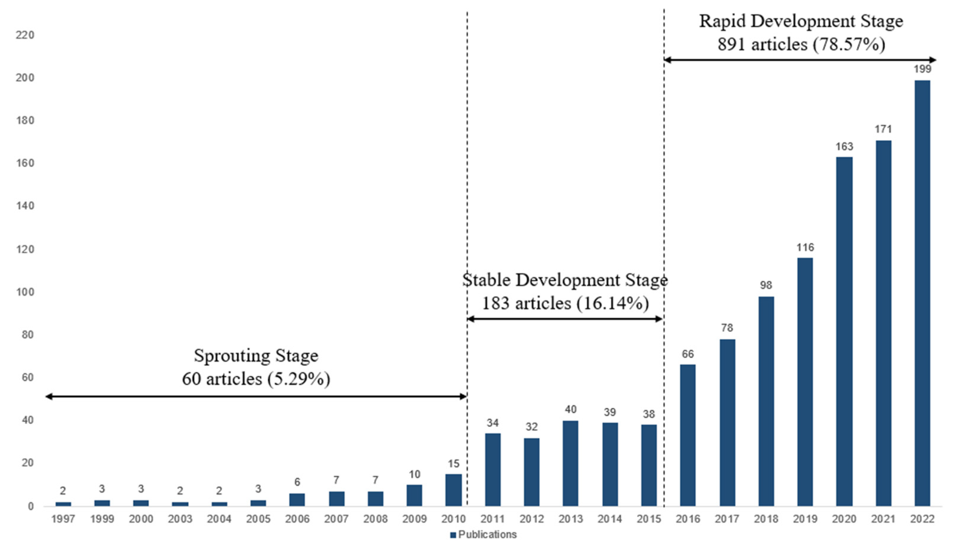
The variation in the annual publication volumes of articles related to urban flood vulnerability is shown in Figure 1. The first article was published in 1997, and the annual number of publications on this topic generally shows an upward trend. Based on the annual publication numbers, the study period can be divided into three stages:
The sprouting stage (1997–2010): in this stage, a total of 60 articles were published, only accounting for 5.29% of the total publications. It shows that the research on urban flood vulnerability was in its initial stages, and scholars did not pay sufficient attention to this field. However, there was a slight increase observed in the number of articles, from two articles in 1997 to fifteen articles in 2010, indicating a slowly growing research interest in this field during this stage.
The stable development stage (2011–2015): from 2011 to 2015, the number of articles significantly increased compared to the previous stage, maintaining a relatively stable annual publication number of around 36 on average. During this period, urban flood vulnerability began to attract stable attention from academic communities.
The rapid development stage (2016-present): the number of published articles in 2016 (66 articles) was almost twice as much as that of 2015 (38 articles), and the publication volume showed a dramatically increasing trend, reaching a peak in 2022 (199 articles). A total of 891 articles were published at this stage, accounting for 78.57% of the total. Therefore, it is inferred that the field of urban flood vulnerability has attracted substantial attention from academic communities and has reached a stage of flourishing development.
3.1.2. Discipline Categories
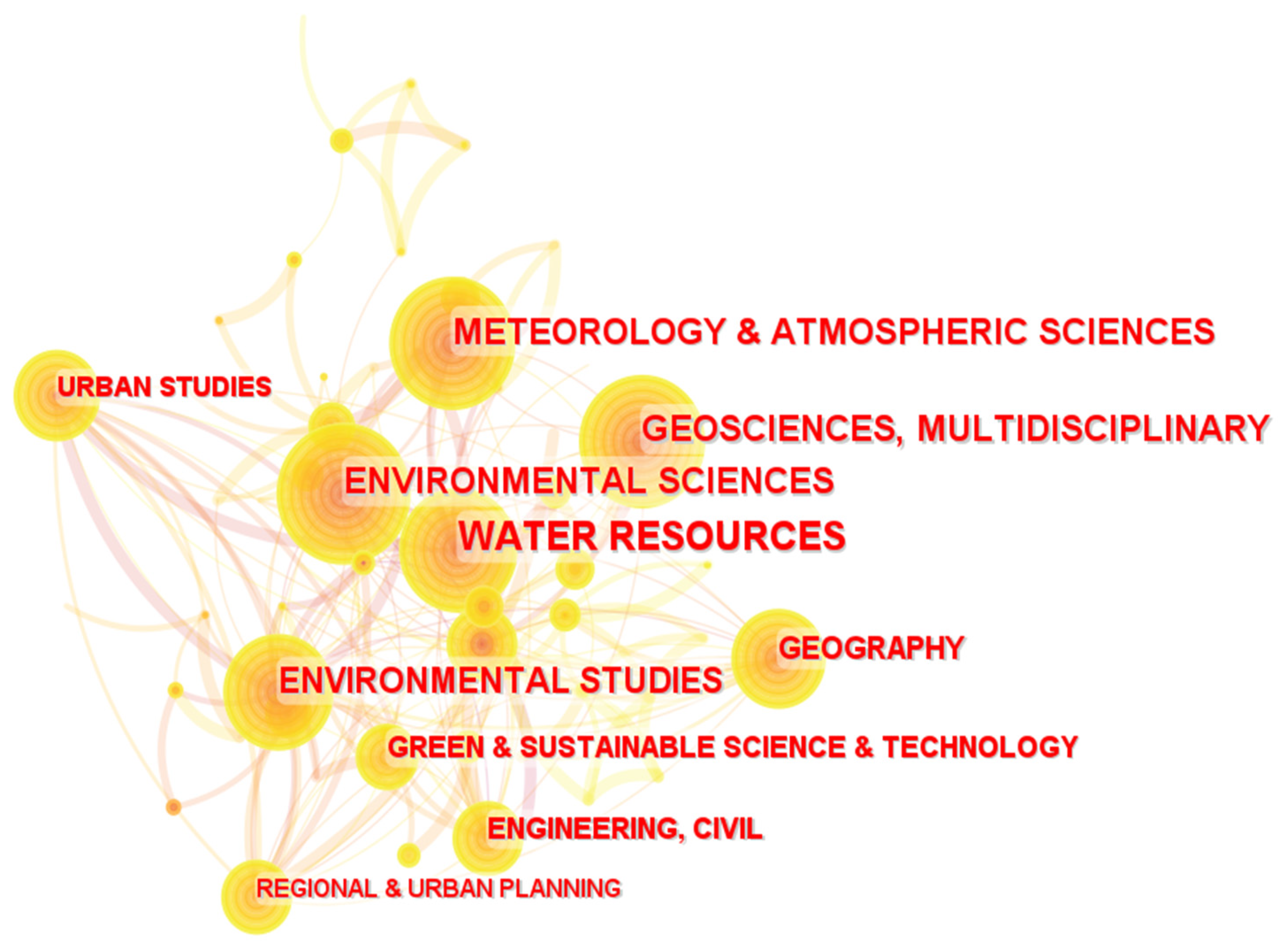
The participation and integration of different disciplines in the development of a certain research field can be revealed by generating a discipline co-occurrence network. Figure 2 shows the distribution of the disciplines involved in research related to urban flood vulnerability. Each node represents a discipline, and the size of the node corresponds to the contribution of this discipline. In addition, the dense links between various nodes indicate frequent intersections between multiple disciplines. Table 1 lists the top 15 disciplines related to urban flood vulnerability in terms of occurrence count and the years of their first occurrence. Five disciplines with a number of publications exceeding 200 were identified, namely water resources (414 articles), environmental science (315 articles), geoscience (289 articles), meteorology and atmosphere science (250 articles) and environmental studies (205 articles). In addition, geography, civil engineering, urban studies, regional and urban planning, environmental engineering and multidisciplinary science were also significant disciplines involved in this field.
3.2. Cooperation Network Analysis
3.2.1. Cooperation Network of Countries
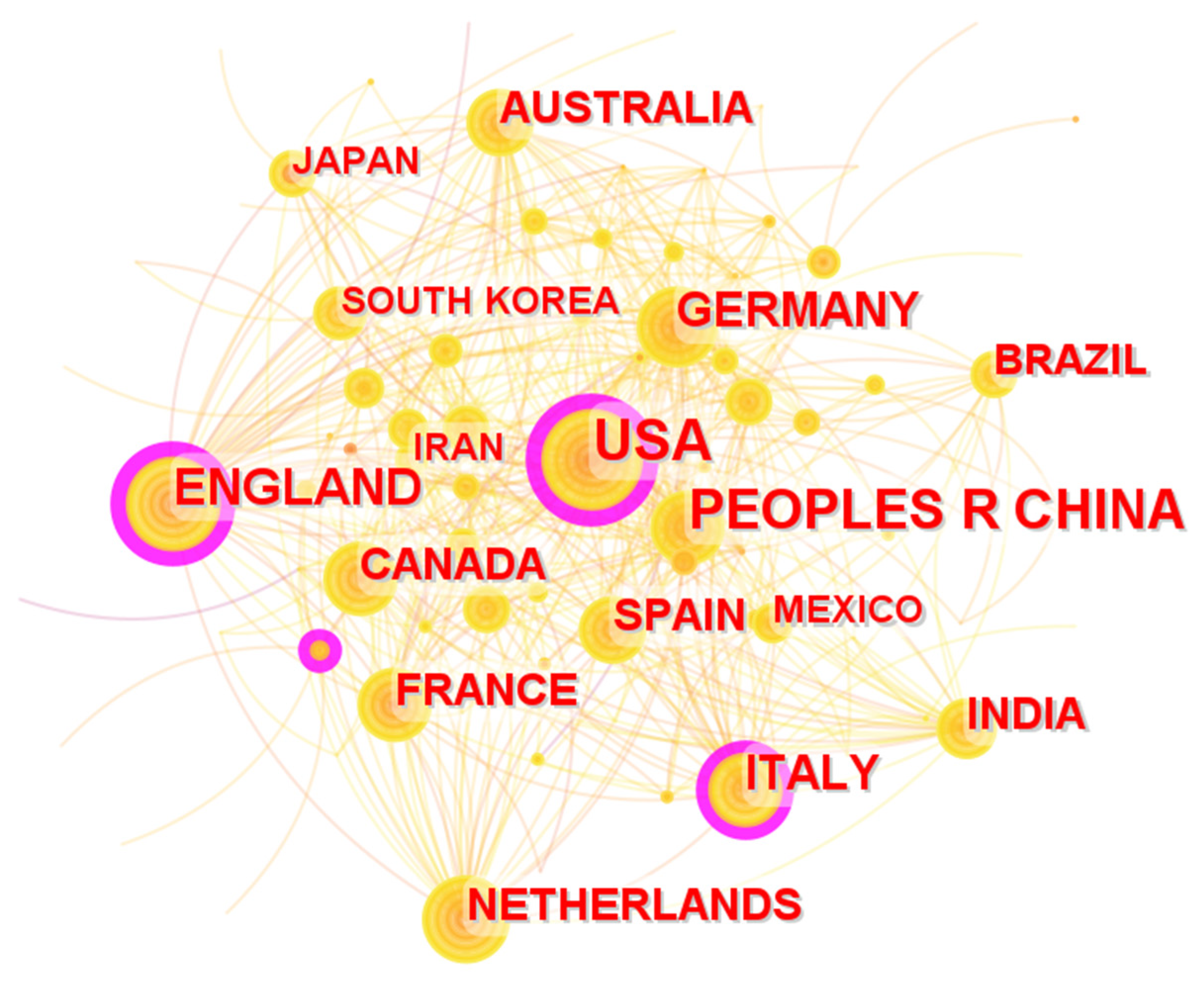
The cooperation network of the countries contributing to research related to urban flood vulnerability is depicted in Figure 3. The size of each node represents the publication number of a country, and the links between the nodes indicate the correlation of the country with each other. The major contributing countries mainly included the United States, China, England, Germany, Italy, Netherlands, etc. Table 2 lists the top 10 most contributing countries in the field of urban flood vulnerability and the years of their first occurrences. Three countries with more than 100 publications were identified. The United States was the country with the most publications, totaling 213 articles, followed by China and England, which published 112 and 101 articles, respectively. Table 2 also shows the betweenness centrality of each country. The betweenness centrality of a node refers to the number of times a node serves as the intermediary ‘bridge’ between the other nodes in the network, and it is considered to be an indicator of the node’s importance. England, the United States, Germany and Italy were the four countries with a betweenness centrality of more than 0.1.
3.2.2. Cooperation Network of Institutions
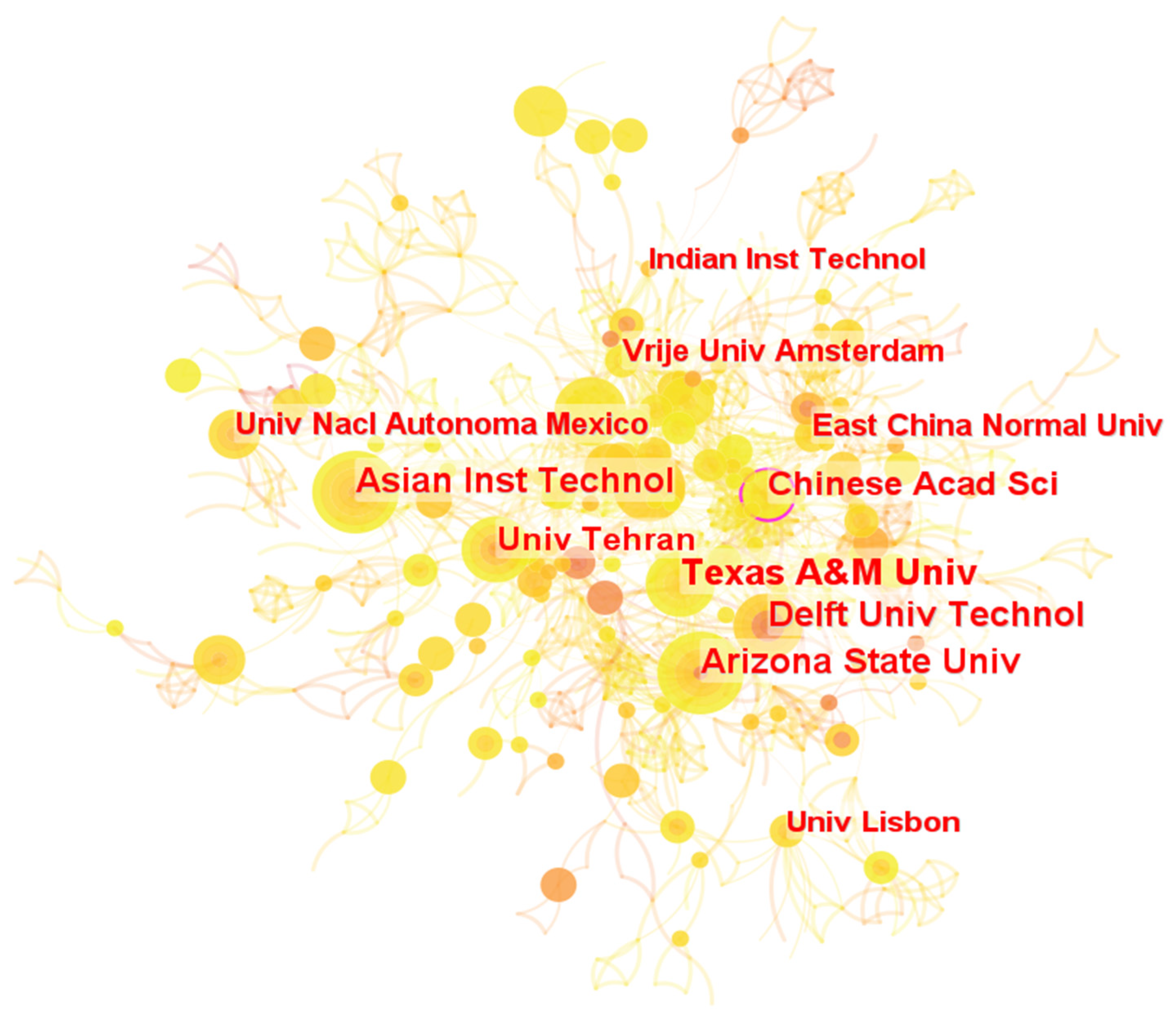
Figure 4 exhibits the cooperation network and the distribution of institutions related to urban flood vulnerability research. Each node represents an institution, and the node size corresponds to the number of publications. The top 10 institutions with the most significant contributions and the years of their first occurrences are listed in Table 3. Texas A&M University, Asian Inst Technol and Arizona State University were the top three institutions with the most publications (22, 18 and 18 articles, respectively), followed by Delft Univ Technol (16 articles) and the Chinese Academy of Science (16 articles). Regarding the betweenness centrality, the Chinese Academy of Science ranked first place, with a centrality of 0.13, and Arizona State University (0.09) and East China Normal University (0.08) were in second and third place.
3.2.3. Cooperation Network of Authors
The cooperation network of authors was established, as shown in Figure 5. Each node represents an author, and the size of the node represents the contribution of the author. The most contributing authors and the years of their first occurrences are listed in Table 4, showing that 15 authors published five articles or more. Specifically, Irfan Ahmad Rana, who was the leading author with the most publication (eight articles), followed by Siyu Yu and Shangjia Dong, who both published seven articles, respectively.
3.3. Co-Citation Analysis
3.3.1. Co-Cited Journals
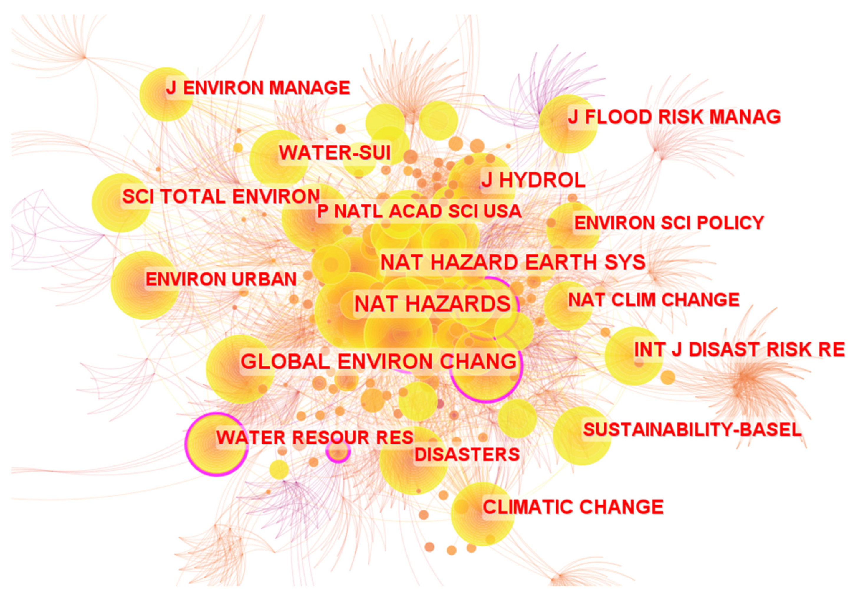
Journal co-citation analysis can reflect academic contribution and influence in the research field of urban flood vulnerability in terms of various journals [52]. The network of co-cited journals was generated, and it is visualized in Figure 6. Each node represents a major cited journal of which the size reflects the co-citation frequency of the corresponding journal. Table 5 shows the top 10 journals in terms of co-citation frequency, their impact factors and their publishers. Natural Hazards was the most frequently cited journal in terms of research relating to urban flood vulnerability, with a co-cited frequency of 624. Other major influential journals included Natural Hazards and Earth System Science (417 citations), Global Environmental Change (410 citations), the Journal of Hydrology (388 citations) and the International Journal of Disaster Risk Reduction (308 citations). The above top journals were cited most frequently, indicating that these journals have made significant contributions to urban flood vulnerability research.
3.3.2. Co-Cited Literature
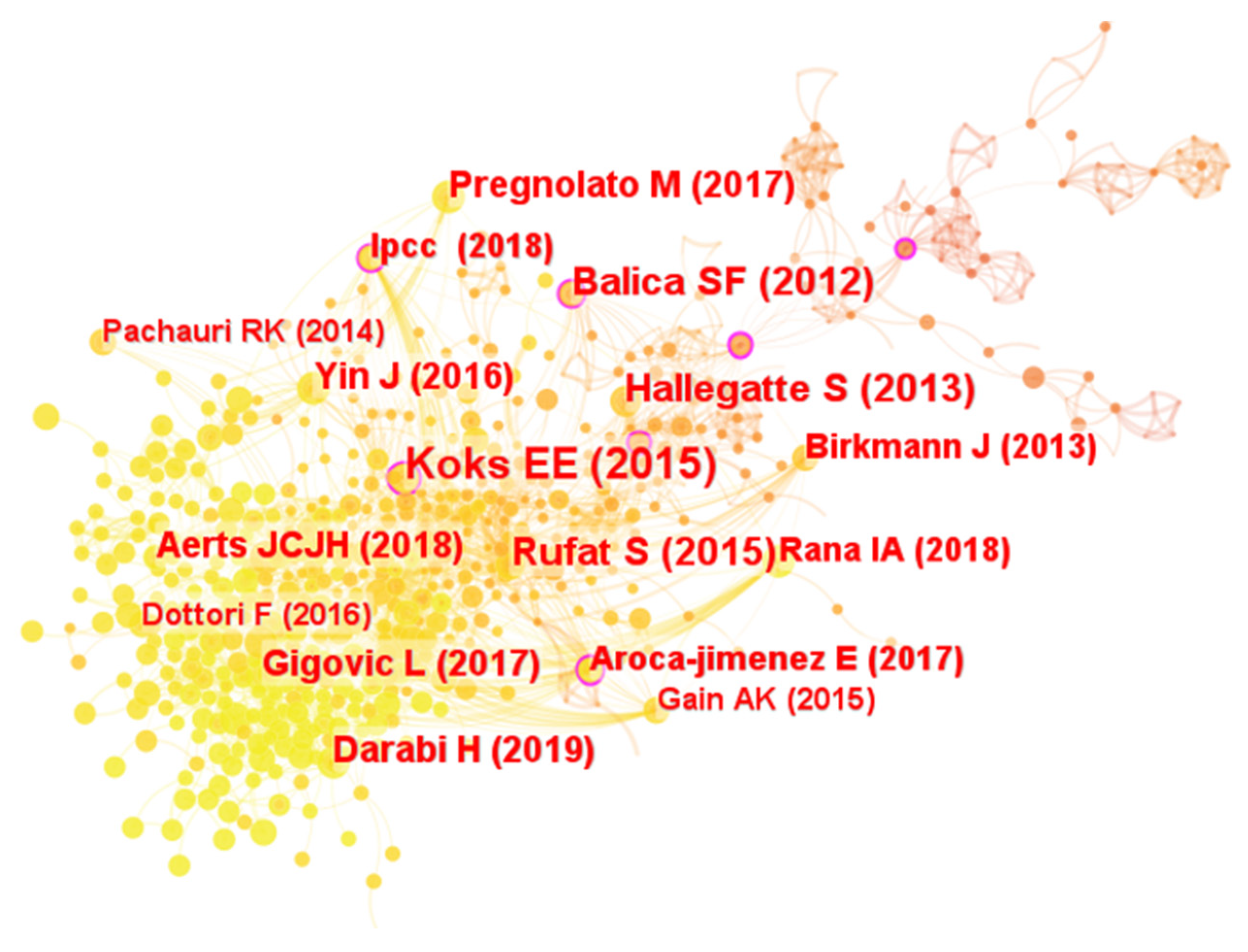
Literature co-citation analysis can be used to identify the most influential documents and summarize the primary academic achievements in the research field [53]. Figure 7 shows the network of co-cited articles in the field of urban flood vulnerability. Each node represents an article, and the node size represents the citation frequency of the article. Table 6 lists the top 10 most influential articles in this field by citation frequency, their authors and the years of their publications. The article by E.E. Koks et al. (2015) [54] was the most-cited, with 30 citations, which was followed by the article by S.F. Balica et al. (2012) [55] and the article by S. Rufat et al. (2015) [56].
From the perspective of research hotspots, the majority of the top 10 most cited articles focused on evaluating the holistic risks and impacts caused by flood disasters. Koks et al. [54] proposed a framework for a joint assessment of flood hazard, exposure and vulnerability to evaluate the effects of flood risk management strategies. Gigović et al. [58] and Darabi et al. [62] produced a flood risk map by adopting a GIS multi-criteria methodology and machine learning technologies, respectively. Hallegatte et al. [57] quantified present and future flood losses and identified the most vulnerable cities where the most significant losses were expected. Balica et al. [55] developed a flood vulnerability index for coastal cities, and Birkmann et al. [16] outlined a systematic vulnerability assessment framework to conceptualize the multi-faceted nature of vulnerability.
On the other hand, the other articles mainly focused on a certain specific issue related to urban flood vulnerability. Rufat et al. [56] profiled the leading factors influencing social vulnerability to flood disasters. Aerts et al. [60] emphasized that integrating societal behavior can be conducive to more accurately assessing flood risk and management strategies. Pregnolato et al. [59] and Yin et al. [61] investigated the impacts of floods on road transport networks. By reviewing the top 10 cited articles, a consensus can be drawn that vulnerability is regarded as a crucial aspect of flood risk analysis and management. The scholars endeavored to enhance the effectiveness of flood risk assessment and response strategies coping with flood disasters by promoting a comprehensive understanding of urban flood vulnerability.
3.4. Term Analysis
3.4.1. Term Co-Occurrence Analysis
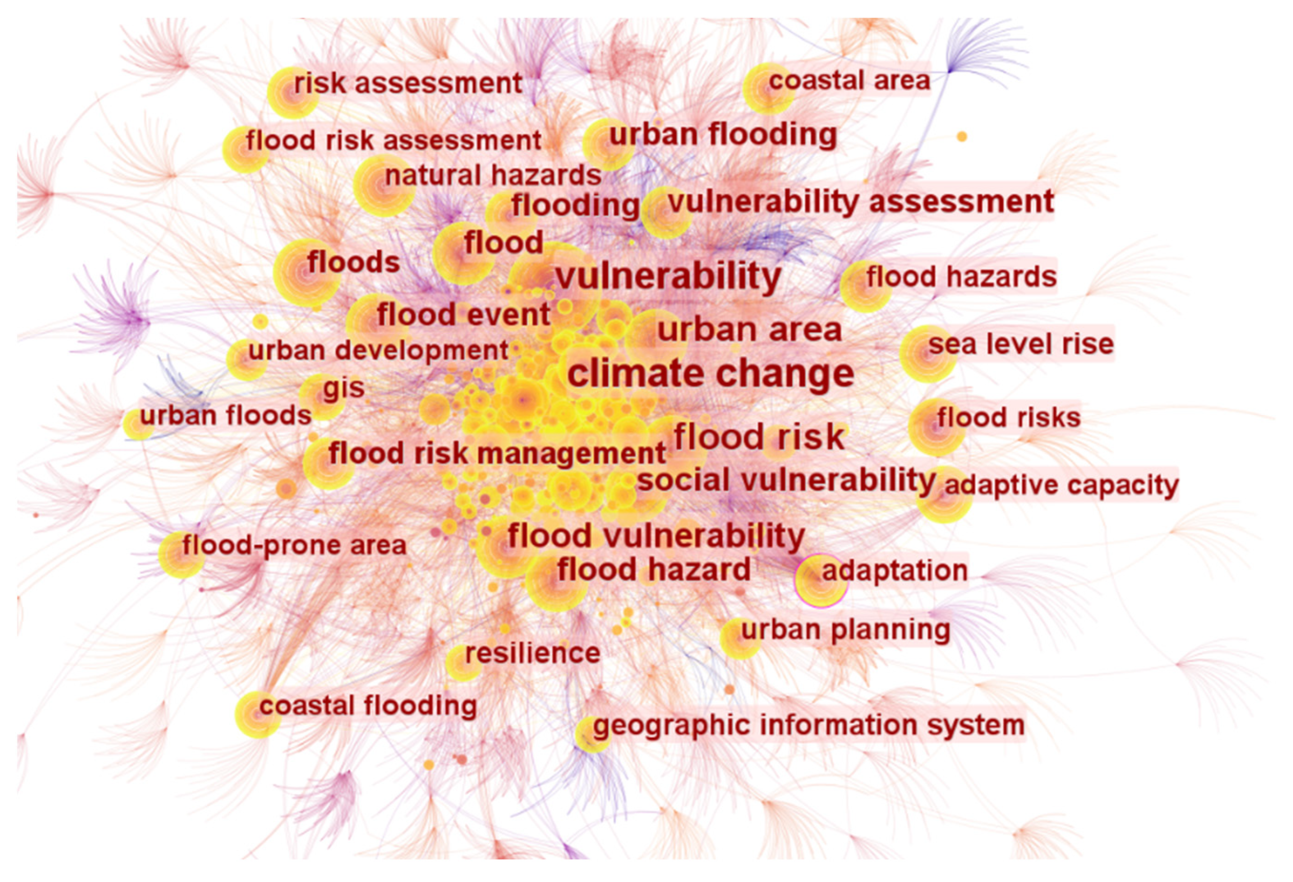
Term co-occurrence analysis can provide insights into the thematic focuses of the research field [43,44]. Based on the statistical analysis using CiteSpace software, 252 terms with an occurrence frequency of five or more were detected. Figure 8 visualizes the term co-occurrence network during the whole study period, in which each node represents a term, and the size of the node represents the occurrence frequency of the term. In addition, each link between the different nodes denotes the strength of the co-occurrence between the two terms. Table 7 summarizes the top 20% of newly emerged terms in three different stages and the years of their first to explore more detailed information concerning the research hotspots and reveal the temporal evolution of research topics. From 1997 to 2010, the research in this field was in its initial creative period, with the most high-frequency terms, totaling 122, accounting for 48.41% of the total. From 2011 to 2015, although the number of publications increased significantly, the number of new terms inversely decreased to 107 (42.46% of the total). Since 2016, the emergence of new terms has significantly reduced in spite of the exponential growth of publication numbers. This phenomenon may be explained by the fact that most of the relevant terms have already been defined during the previous stages. Based on the high-frequency terms, the research focuses can be reflected from multiple perspectives, including research content, research methods, research subjects and research contexts.
From 1997 to 2010, the term that most frequently occurred was Climate change, with an occurrence frequency of 270, and it is the term with the highest occurrence frequency throughout the entire study period. On the one hand, research relating to urban flood vulnerability developed in the context of increasing frequencies and intensities of flood events caused by climate change. On the other hand, climate change can be regarded as the most important factor influencing urban flood vulnerability. Several terms related to natural hazards (e.g., flood hazard and sea level rise) and those related to urbanization (e.g., urban development) can also be considered influential factors. Social vulnerability and vulnerability assessment indicated that the research mainly focused on the social aspect of urban flood vulnerability and the evaluation of urban flood vulnerability at this stage. The information related to research methods was also reflected. Geographic information system was widely adopted in this stage. Vulnerability index, social vulnerability index and flood vulnerability index, which were not included in the top 20% of terms, as shown in Table 7, also emerged, indicating that an indicator-based approach was a mainstream method during this stage. In addition, the research subject and geographic distribution in this field were reflected by urban area, coastal area, coastal cities and developing countries, indicating that the cities in coastal areas and developing countries received significant attention. Moreover, flood risk, flood risk management and flood risk assessment demonstrated a significant correlation between flood vulnerability and flood risk.
From 2011 to 2015, the emergence of resilience (the most frequent term in this stage) and urban resilience represented that the researchers had been associating urban flood vulnerability with the concept of urban resilience. The terms, including extreme weather event, urban growth, rapid urbanization, road network and population density, represented the fact that the impacts of climate change and urbanization on urban flood vulnerability received enduring attention. Spatial distribution and spatial analysis reflected that the spatial variation of urban flood vulnerability had become a fresh research hotspot during this stage. Meanwhile, some terms, which were not included in the top 20%, such as physical vulnerability, socio-economic vulnerability and environmental vulnerability, also emerged, indicating that urban flood vulnerability was started to be explored from more diversified aspects in this stage. The terms related to research methods entered the peak emerging period in this stage. Analytical hierarchy process was the most significant method, followed by sensitivity analysis. In addition, other terms related to research methods and data, such as principle component analysis, field survey, vulnerability curve, census data and remote sense (not shown in Table 7), were also involved. The most important new subject term was metropolitan area, and global south also emerged as a main research subject.
Since 2016, during the rapid development stage, community vulnerability has been the newly emerged term with the highest occurrence frequency. The attention to the impact of urban development was maintained, which was reflected by land use planning and land cover. In terms of research methods, hydraulic model and storm water management model (not shown in Table 7) reflected the fact that hydrological modeling approaches had become one of the mainstream methods. In addition, with the recent development of big data technology, machine learning was also involved in this field. The terms related to research subjects were generally consistent with those in the previous period, which were mainly focused on developing countries (e.g., Accra, Ghana and Brazil, which were not shown in Table 7).
3.4.2. Timeline of Term Clusters
Figure 9 shows the timeline of the top 10 most significant clusters in the field of urban flood vulnerability. Among these clusters, “climate change” had the longest duration, which existed throughout the entire study period from 1997 to the present. It is regarded as the most significant factor influencing urban flood vulnerability. The cluster with the largest size was “flood risk management”, which was active from 1999 to 2019. In this paper, flood risk management was considered to be an important objective of urban flood vulnerability studies. The main terms under this cluster included adaption opinions, impact assessment, flood intensity, risk reduction, etc.
The clusters of “urban flood”, “vulnerability assessment” and “flood hazard map” also emerged in the early phase of the study period and maintained active until the present. Specifically, “urban flood” and “flood hazard map” involved the key terms including fluvial flood, flood modeling, urban flood prediction and geospatial analysis. These two clusters indicated that the hydrological process of flood disasters attracted constant attention from the academic community. In addition, “vulnerability assessment”, of which the main terms included social vulnerability and indicator-based approach, reflected that the evaluation of urban flood vulnerability was a core topic of urban flood vulnerability research.
Since the mid-term of the study period (around 2005), “urban areas” and “land use change” became significant clusters, with the key terms of building construction, social environment, ecosystem service, etc. The appearance of these two clusters may be a sign that the attention of studies in this field started to broaden, from flood hazards to the characteristics of the built environment of urban systems. In addition, “urban resilience” and “flood resilience” also emerged during this period, indicating that one of the objectives of the studies is to support the establishment and promotion of resilient cities. Furthermore, “vulnerability mapping” was the latest cluster, appearing around 2011, emphasizing that the spatial distribution of high-vulnerability areas has received increasing attention.
4. Discussion
4.1. Current Research Focuses of Urban Flood Vulnerability
This study reveals the research focuses and development trajectory of urban flood vulnerability studies by analyzing the term co-occurrence network and term cluster evolution of this field. Based on the previous results, the major research focuses present in this field are as follows:
“Flood risk management” is observed as the largest cluster in the CiteSpace analysis. It reveals the significant correlation between urban flood vulnerability and flood risk management, which is confirmed through the previous analysis of the top-cited literature. Flood vulnerability is widely considered to be one of the fundamental components of flood risk function, juxtaposed with hazard and exposure [63,64,65,66]. Flood risk is a comprehensive concept integrating the probability of flood hazards and the degree of negative consequences [67]. Fuchs et al. [68] argued that the consequences of a natural hazard are significantly connected to the vulnerability of the elements at risk, irrespective of the magnitude and spatial extent of the hazards. In other words, flood vulnerability can be regarded as a partial perspective of flood risk focusing on describing the inclination and potential to suffer losses or damage due to flood hazards [69]. Consequently, a more precise perception of flood risk, which is considered to be a crucial prerequisite in terms of flood risk reduction, can be achieved by exploring a more comprehensive understanding of vulnerability [9,70,71,72].
The term clusters of “urban resilience” and “flood resilience” show that current studies commonly associate urban flood vulnerability with urban resilience. In general, flood vulnerability and flood resilience are two overlapping and distinguishing concepts. Flood resilience is widely accepted as a holistic conceptual framework for flood mitigation that emphasizes the integration of the ability to tolerate flooding and to reorganize in the face of disruption [4,73,74,75]. Meanwhile, flood vulnerability primarily focuses on the exposure and potential damage to the social–ecological system [22]. Moreover, several studies have further explored the relationship between flood vulnerability and resilience. For instance, Sun et al. [76] suggest that clarifying the correlation between vulnerability and resilience is beneficial for comprehensively quantifying flood resilience. Meanwhile, Song et al. [77] indicate that the deficiency and inequality of adaption resources to flood disasters can exacerbate the vulnerability of urban areas. In contrast, the assessment of vulnerability may provide important implications regarding flood resilience enhancement, particularly in relation to advising the allocation of resources. Percival and Teeuw [78] point out that assessing vulnerability can contribute to more effectively targeting interventions to enhance resilience.
The term cluster of “vulnerability assessment” appeared during the very early stage, indicating that assessing vulnerability is a central topic throughout the entire study period. Previous studies have endeavored to profile the fundamental characteristics underlying flood vulnerability. For the temporal evolution of research, the research mainly concentrated on the perspectives of public policies, topographic conditions and the hydraulic characteristics of floods in the first decade [79,80,81,82]. Although a few studies also glanced at social-demographical features, these features were not emphasized in this period [83,84]. However, since 2009, terms such as social vulnerability, socio-economic vulnerability and community vulnerability have emerged, indicating that the diversified aspects of flood vulnerability were emphasized in the theoretical research. In terms of the research methodology, the major approaches applied for vulnerability assessment included the indicator-based method [18,55,85,86,87] and vulnerability curve [88,89]. The indicator-based method was most dominant in this field, and was applied to various study subjects and scales, and the indicators were usually selected by the researchers based on their respective objectives [90,91]. During this process, various studies selected a wide range of indicators, including, but not limited to, demographic structure, socio-economic status, employment and education situation, household composition, coping capacity, etc. [38,54,56,86,92]. Moreover, the weight of each indicator was mainly identified by using the analytical hierarchy process [72,93,94] or principal component analysis [86,95,96]. On the other hand, the vulnerability curve (or function) was mainly used to assess the physical dimension of flood vulnerability based on exploring the relationship between flood hazard and the degree of damage or loss [89,97].
Terms such as spatial pattern and spatial distribution, and the cluster “vulnerability mapping”, which started to emerge from the mid-term of the study period, reflect that analyzing the spatial characteristics of urban flood vulnerability is an important research topic. Identifying the spatial variation of vulnerable areas to flood is an essential task for vulnerability assessment as it can facilitate decision makers in establishing more effective management policies and strategic planning to prevent and mitigate flood impacts [18,19,42,98]. Previous studies have attempted to map the vulnerability to flood at various scales, including the city scale, district scale and community scale [18,55,99,100]. The main approaches involved included modeling methods based on GIS [19,94,101], flood models [102,103], coupled models [40,104,105], machine learning algorithms [106,107,108], etc. GIS-based modeling and flood modeling were two types of tools commonly used to identify flood-prone areas. GIS-based modeling mainly determined the potential inundation area simply through topography analysis and only required the DEM of the study area and the peak level of floodwater [109]. Flood modeling involved hydrological and hydrodynamic principles to simulate the rainfall–runoff process, which can provide more precise outcomes, whereas more computation time and data were required [109]. Furthermore, with the recent development of artificial intelligence technologies, machine learning algorithms have proven reliable for urban flood vulnerability analysis without the need for costly field surveys and complicated hydrodynamic modeling [62,107].
The result of term analysis also highlights the correlation research investigating the impacts of climate change and urbanization on urban flood vulnerability. Term co-occurrence analysis shows that the influential factors affecting urban flood vulnerability can be grouped into the factors related to climate change and those related to urbanization. The term clusters of “land use change” and “climate change” also confirm the academic attention on the correlation between climate change, the urbanization process and urban flood vulnerability. Many scholars have investigated the role of climate change in altering flood hazards and vulnerabilities. It is evident that climate change has a significant correlation with a series of natural phenomena, such as aggravating sea level rise and changing precipitation patterns, resulting in the increasing frequency and intensity of flood hazards [110,111,112,113,114]. In addition, the physical vulnerability of individuals to floods can be further affected due to physical instability and drowning caused by changes in flood hazards [115]. On the other hand, the impact of the urbanization process on flood vulnerability is also discussed widely. The sprawl of cities and the increasing impervious surfaces due to the process of urbanization have altered the hydrological processes in urban areas, increasing surface runoff [116,117]. Moreover, the concentration of population, infrastructure and assets in urban areas can lead to higher potential losses in terms of lives and property when flood events occur [15,118].
In terms of the research subjects, the term co-occurrence network indicates that the cities in the coastal area and developing countries are highly concentrated. Coastal areas are not only more likely to aggregate populations, settlements and human activities but are also commonly located in lower-lying areas where flood hazards can be exacerbated by subsidence and sea level rise. Therefore, case studies concerning urban flood vulnerability in coastal areas were largely observed during the entire study period [78,82,95,119,120,121]. Furthermore, the cooperation network of countries shows that the practical applications were mainly initially conducted in developed countries in North America and Europe in the earlier stage. However, the result of term analysis indicates that developing countries have received enduring attention recently, including Brazil [122], Ghana [123], Nigeria [124], Indonesia [125], Malaysia [126], Vietnam [127], etc. It is believed that developing countries are more vulnerable to flood events due to the rapidly increasing population, disorderly urban planning and inadequate infrastructure [42,128,129].
4.2. Future Prospects
In the context of global climate change and urbanization processes, research concerning urban flood vulnerability is expected to maintain a continuously expanding trend in the future. The following prospects for future research are proposed with the goal of inspiring researchers and practitioners with new insights for promoting the development progress in this field.
Initially, the optimization of vulnerability assessment is expected to be a significant direction for future research. With the development of research in this field, the scope of flood vulnerability has been expanded to various dimensions, and a wide range of indicators to assess vulnerability has been identified. However, the vulnerability is mainly evaluated by obtaining a “total vulnerability score” without considering the interaction between the different indicators. In addition, there is also a lack of investigation into the situational variability of flood vulnerability indicators. For instance, the effect of the same indicator on flood vulnerability may be diametrically opposed in different scenarios. Consequently, urban flood vulnerability needs to be evaluated while considering the intersection between the indicators and the temporal variations of specific indicators throughout the progression of flood disasters.
Moreover, an in-depth study combing flood vulnerability with flood risk and flood resilience also deserves further attention. Research related to urban flood vulnerability is recognized as being closely related to these two concepts. Vulnerability has become increasingly crucial in research concerning flood risk, and researchers are expected to continually seek ways to mitigate flood risk from the perspective of reducing urban flood vulnerability. In addition, a growing number of studies have attempted to combine flood vulnerability with flood resilience. However, more endeavors are necessary to adequately elaborate their intrinsic connection. Therefore, the intrinsic relationship between flood vulnerability, flood risk and flood resilience can be further investigated in the future.
5. Conclusions
This study retrieved 1134 articles on urban flood vulnerability published between 1997 and 2022 from the WoS Core Collection database and undertook a bibliometric analysis using CiteSpace software to depict the research status and development trends in this field. The literature was comprehensively reviewed from multiple perspectives, including publication volumes and trends, distribution of disciplines, cooperation networks in terms of countries, institutions and authors, co-citation analysis of journals and literature, as well as term analysis.
This study concludes that the development of research related to urban flood vulnerability has exhibited an upward trajectory, characterized by three stages in terms of publication volumes: the sprouting stage, the stable development stage and the rapid development stage. During the process, there has been a clear trend towards interdisciplinary studies in this field, with water resources, environmental science and geoscience being the major disciplines involved. In addition, the United States, China, England and Germany provided the most publications among all of the countries involved in this field. Texas A&M University, Asian Inst Technol, Arizona State University, Delft Univ Technol and the Chinese Academy of Science were among the top institutions in terms of publication number. In terms of co-citation analysis, Natural Hazards, Natural Hazards and Earth System Sciences and Global Climate Change were the top-cited journals. The most influential literature was the article proposed by Koks et al. in 2015 [54]. Based on the results of term co-occurrence analysis and term cluster analysis, vulnerability assessment and mapping emerge as primary research focuses. The research has evolved from a narrow focus on physical vulnerability to integrating a multidimensional exploration of vulnerability, including social, economic and community dimensions. Additionally, investigating the impacts of climate change and urbanization on urban flood vulnerability has become an enduring research topic, while integrating urban flood vulnerability with flood risk and urban resilience has also become a significant area of interest. Furthermore, this study also suggests potential areas of interest for future research in this field, including the further optimization of vulnerability assessments and in-depth studies considering the intrinsic relationships between flood vulnerability, flood risk and flood resilience.
This study fills the gap by providing a holistic panorama of the entire research status and the development process on urban flood vulnerability, which has been lacking in previous studies. It contributes to grasping the current mainstream research topics in this field for researchers and practitioners, as well as obtaining insights into the prospects for future research.
On the other hand, despite the contributions made in this study, the following limitations still exist. To begin with, the literature collection in this study was based on the data in the WoS Core Collection with the language set of English, leading to the omission of publications from other databases and those written in languages other than English. Non-academic documents, such as book reviews, government policies and documents published by other authoritative organizations were also excluded from this study. Thus, a more comprehensive consideration of multiple databases with various document types and languages is necessary. In addition, the outcomes of the literature in the WoS Core Collection significantly depend on the settings applied in the search strategies. With the update of relevant research, more keywords and document types can be involved in search strategies to collect more detailed information. Furthermore, several different bibliometric analysis tools have been developed, such as VOSviewer, HistCite, SATI, etc. Approaches combining various tools can be attempted to improve the performance of the literature analysis and visualization.
Author Contributions
Conceptualization, S.L., J.H. and J.W.; methodology, S.L; software, J.H.; validation, S.L., J.H. and J.W.; formal analysis, S.L.; investigation, S.L.; resources, S.L.; data curation, S.L.; writing—original draft preparation, S.L.; writing—review and editing, S.L.; visualization, J.H.; supervision, J.H. and J.W.; project administration, J.H.; funding acquisition, J.H. All authors have read and agreed to the published version of the manuscript.
Funding
This research received no external funding.
Data Availability Statement
The data presented in this study are available on request from the corresponding author.
Conflicts of Interest
The authors declare no conflict of interest.
References
- Wang, L.; Gong, Z.; Shi, L.; Hu, Z.; Shah, A.A. Knowledge mapping analysis of research progress and frontiers in integrated disaster risk management in a changing climate. Nat. Hazards 2021, 107, 2033–2052. [Google Scholar] [CrossRef]
- Ruan, J.; Chen, Y.; Yang, Z. Assessment of temporal and spatial progress of urban resilience in Guangzhou under rainstorm scenarios. Int. J. Disaster Risk Reduct. 2021, 66, 102578. [Google Scholar] [CrossRef]
- Balaguru, K.; Foltz, G.R.; Leung, L.R.; Emanuel, K.A. Global warming-induced upper-ocean freshening and the intensification of super typhoons. Nat. Commun. 2016, 7, 13670. [Google Scholar] [CrossRef]
- Liao, K.-H.; Le, T.A.; Nguyen, K.V. Urban design principles for flood resilience: Learning from the ecological wisdom of living with floods in the Vietnamese Mekong Delta. Landsc. Urban Plan. 2016, 155, 69–78. [Google Scholar] [CrossRef]
- Zhang, H.; Yang, J.; Li, L.; Shen, D.; Wei, G.; Khan, H.u.R.; Dong, S. Measuring the resilience to floods: A comparative analysis of key flood control cities in China. Int. J. Disaster Risk Reduct. 2021, 59, 102248. [Google Scholar] [CrossRef]
- Liu, D.; Feng, J.; Li, H.; Fu, Q.; Li, M.; Faiz, M.A.; Ali, S.; Li, T.; Khan, M.I. Spatiotemporal variation analysis of regional flood disaster resilience capability using an improved projection pursuit model based on the wind-driven optimization algorithm. J. Clean. Prod. 2019, 241, 118406. [Google Scholar] [CrossRef]
- Ahmad, S.S.; Simonovic, S.P. Spatial and temporal analysis of urban flood risk assessment. Urban Water J. 2013, 10, 26–49. [Google Scholar] [CrossRef]
- UNISDR. Economic Losses, Poverty & Disasters: 1998–2017; Centre for Research on the Epidemiology of Disasters, United Nations: New York, NY, USA, 2018; 31p, Available online: https://www.undrr.org/publication/economic-losses-poverty-disasters-1998-2017 (accessed on 11 May 2023).
- Cho, S.Y.; Chang, H. Recent research approaches to urban flood vulnerability, 2006–2016. Nat. Hazards 2017, 88, 633–649. [Google Scholar] [CrossRef]
- Pour, S.H.; Wahab, A.K.A.; Shahid, S.; Asaduzzaman, M.; Dewan, A. Low impact development techniques to mitigate the impacts of climate-change-induced urban floods: Current trends, issues and challenges. Sustain. Cities Soc. 2020, 62, 102373. [Google Scholar] [CrossRef]
- Shi, Y.; Zhai, G.; Zhou, S.; Lu, Y.; Chen, W.; Deng, J. How Can Cities Respond to Flood Disaster Risks under Multi-Scenario Simulation? A Case Study of Xiamen, China. Int. J. Environ. Res. Public Health 2019, 16, 618. [Google Scholar] [CrossRef]
- Hammond, M.J.; Chen, A.S.; Djordjević, S.; Butler, D.; Mark, O. Urban flood impact assessment: A state-of-the-art review. Urban Water J. 2013, 12, 14–29. [Google Scholar] [CrossRef]
- Gao, M.; Wang, Z.; Yang, H. Review of Urban Flood Resilience: Insights from Scientometric and Systematic Analysis. Int. J. Environ. Res. Public Health 2022, 19, 8837. [Google Scholar] [CrossRef] [PubMed]
- Li, C.; Cheng, X.; Li, N.; Du, X.; Yu, Q.; Kan, G. A Framework for Flood Risk Analysis and Benefit Assessment of Flood Control Measures in Urban Areas. Int. J. Environ. Res. Public Health 2016, 13, 787. [Google Scholar] [CrossRef] [PubMed]
- Bajracharya, S.R.; Khanal, N.R.; Nepal, P.; Rai, S.K.; Ghimire, P.K.; Pradhan, N.S. Community Assessment of Flood Risks and Early Warning System in Ratu Watershed, Koshi Basin, Nepal. Sustainability 2021, 13, 3577. [Google Scholar] [CrossRef]
- Birkmann, J.; Cardona, O.D.; Carreño, M.L.; Barbat, A.H.; Pelling, M.; Schneiderbauer, S.; Kienberger, S.; Keiler, M.; Alexander, D.; Zeil, P.; et al. Framing vulnerability, risk and societal responses: The MOVE framework. Nat. Hazards 2013, 67, 193–211. [Google Scholar] [CrossRef]
- Chang, L.-F.; Huang, S.-L. Assessing urban flooding vulnerability with an emergy approach. Landsc. Urban Plan. 2015, 143, 11–24. [Google Scholar] [CrossRef]
- Nasiri, H.; Yusof, M.J.M.; Ali, T.A.M.; Hussein, M.K.B. District flood vulnerability index: Urban decision-making tool. Int. J. Environ. Sci. Technol. 2018, 16, 2249–2258. [Google Scholar] [CrossRef]
- Ghajari, Y.; Alesheikh, A.; Modiri, M.; Hosnavi, R.; Abbasi, M. Spatial Modelling of Urban Physical Vulnerability to Explosion Hazards Using GIS and Fuzzy MCDA. Sustainability 2017, 9, 1274. [Google Scholar] [CrossRef]
- Lewis, J. Development in Disaster-Prone Places: Studies of Vulnerability; Intermediate Technology: London, UK, 1999. [Google Scholar]
- Füssel, H.-M. Vulnerability: A generally applicable conceptual framework for climate change research. Glob. Environ. Chang. 2007, 17, 155–167. [Google Scholar] [CrossRef]
- Yang, W.; Xu, K.; Lian, J.; Bin, L.; Ma, C. Multiple flood vulnerability assessment approach based on fuzzy comprehensive evaluation method and coordinated development degree model. J. Environ. Manag. 2018, 213, 440–450. [Google Scholar] [CrossRef]
- Ahsan, M.N.; Warner, J. The socioeconomic vulnerability index: A pragmatic approach for assessing climate change led risks–A case study in the south-western coastal Bangladesh. Int. J. Disaster Risk Reduct. 2014, 8, 32–49. [Google Scholar] [CrossRef]
- Lei, Y.; Wang, J.; Yue, Y.; Zhou, H.; Yin, W. Rethinking the relationships of vulnerability, resilience, and adaptation from a disaster risk perspective. Nat. Hazards 2013, 70, 609–627. [Google Scholar] [CrossRef]
- Beevers, L.; Walker, G.; Strathie, A. A systems approach to flood vulnerability. Civ. Eng. Environ. Syst. 2016, 33, 199–213. [Google Scholar] [CrossRef]
- Tonmoy, F.N.; El-Zein, A.; Hinkel, J. Assessment of vulnerability to climate change using indicators: A meta-analysis of the literature. WIREs Clim. Chang. 2014, 5, 775–792. [Google Scholar] [CrossRef]
- Smit, B.; Wandel, J. Adaptation, adaptive capacity and vulnerability. Glob. Environ. Chang. 2006, 16, 282–292. [Google Scholar] [CrossRef]
- Turner, B.L.; Kasperson, R.E.; Matson, P.A.; McCarthy, J.J.; Corell, R.W.; Christensen, L.; Eckley, N.; Kasperson, J.X.; Luers, A.; Martello, M.L.; et al. A framework for vulnerability analysis in sustainability science. Proc. Natl. Acad. Sci. USA 2003, 100, 8074–8079. [Google Scholar] [CrossRef]
- Adger, W.N. Vulnerability. Glob. Environ. Chang. 2006, 16, 268–281. [Google Scholar] [CrossRef]
- IPCC. Climate Change 2014: Impacts, Adaptation, and Vulnerability. Part A: Global and Sectoral Aspects. Contribution of Working Group II to the Fifth Assessment Report of the Intergovernmental Panel on Climate Change; Cambridge University Press: Cambridge, UK; New York, NY, USA, 2014. [Google Scholar]
- Chan, S.W.; Abid, S.K.; Sulaiman, N.; Nazir, U.; Azam, K. A systematic review of the flood vulnerability using geographic information system. Heliyon 2022, 8, e09075. [Google Scholar] [CrossRef]
- Huang, S.-L.; Chang, L.-F.; Yeh, C.-T. How vulnerable is the landscape when the typhoon comes? An emergy approach. Landsc. Urban Plan. 2011, 100, 415–417. [Google Scholar] [CrossRef]
- Van, C.T.; Tuan, N.C.; Son, N.T.; Tri, D.Q.; Anh, L.N.; Tran, D.D. Flood vulnerability assessment and mapping: A case of Ben Hai-Thach Han River basin in Vietnam. Int. J. Disaster Risk Reduct. 2022, 75, 102969. [Google Scholar] [CrossRef]
- Rana, I.A.; Routray, J.K. Actual vis-à-vis perceived risk of flood prone urban communities in Pakistan. Int. J. Disaster Risk Reduct. 2016, 19, 366–378. [Google Scholar] [CrossRef]
- Srinivasan, V.; Seto, K.C.; Emerson, R.; Gorelick, S.M. The impact of urbanization on water vulnerability: A coupled human–environment system approach for Chennai, India. Glob. Environ. Chang. 2013, 23, 229–239. [Google Scholar] [CrossRef]
- Balica, S.F.; Popescu, I.; Beevers, L.; Wright, N.G. Parametric and physically based modelling techniques for flood risk and vulnerability assessment: A comparison. Environ. Model. Softw. 2013, 41, 84–92. [Google Scholar] [CrossRef]
- Li, C.H.; Li, N.; Wu, L.C.; Hu, A.J. A relative vulnerability estimation of flood disaster using data envelopment analysis in the Dongting Lake region of Hunan. Nat. Hazards Earth Syst. Sci. 2013, 13, 1723–1734. [Google Scholar] [CrossRef]
- Rasch, R. Income Inequality and Urban Vulnerability to Flood Hazard in Brazil*. Soc. Sci. Q. 2017, 98, 299–325. [Google Scholar] [CrossRef]
- Fang, C.; Wang, Y.; Fang, J. A comprehensive assessment of urban vulnerability and its spatial differentiation in China. J. Geogr. Sci. 2015, 26, 153–170. [Google Scholar] [CrossRef]
- Li, W.; Lin, K.; Zhao, T.; Lan, T.; Chen, X.; Du, H.; Chen, H. Risk assessment and sensitivity analysis of flash floods in ungauged basins using coupled hydrologic and hydrodynamic models. J. Hydrol. 2019, 572, 108–120. [Google Scholar] [CrossRef]
- Rehman, S.; Sahana, M.; Hong, H.; Sajjad, H.; Ahmed, B.B. A systematic review on approaches and methods used for flood vulnerability assessment: Framework for future research. Nat. Hazards 2019, 96, 975–998. [Google Scholar] [CrossRef]
- Membele, G.M.; Naidu, M.; Mutanga, O. Examining flood vulnerability mapping approaches in developing countries: A scoping review. Int. J. Disaster Risk Reduct. 2022, 69, 102766. [Google Scholar] [CrossRef]
- Liu, Y.; Li, Q.; Li, W.; Zhang, Y.; Pei, X. Progress in urban resilience research and hotspot analysis: A global scientometric visualization analysis using CiteSpace. Environ. Sci. Pollut. Res. Int. 2022, 29, 63674–63691. [Google Scholar] [CrossRef]
- Wang, X.; Zhang, Y.; Zhang, J.; Fu, C.; Zhang, X. Progress in urban metabolism research and hotspot analysis based on CiteSpace analysis. J. Clean. Prod. 2021, 281, 125224. [Google Scholar] [CrossRef]
- Jia, B.; Chen, Y.; Wu, J. Bibliometric Analysis and Research Trend Forecast of Healthy Urban Planning for 40 Years (1981–2020). Int. J. Environ. Res. Public Health 2021, 18, 9444. [Google Scholar] [CrossRef] [PubMed]
- Li, H.; Wang, W. Knowledge Domain and Emerging Trends of Social Vulnerability Research: A Bibliometric Analysis (1991–2021). Int. J. Environ. Res. Public Health 2022, 19, 8342. [Google Scholar] [CrossRef]
- da Silva, L.B.L.; Alencar, M.H.; de Almeida, A.T. Multidimensional flood risk management under climate changes: Bibliometric analysis, trends and strategic guidelines for decision-making in urban dynamics. Int. J. Disaster Risk Reduct. 2020, 50, 101865. [Google Scholar] [CrossRef]
- Zha, X.; Luo, P.; Zhu, W.; Wang, S.; Lyu, J.; Zhou, M.; Huo, A.; Wang, Z. A bibliometric analysis of the research on Sponge City: Current situation and future development direction. Ecohydrology 2021, 14, e2328. [Google Scholar] [CrossRef]
- Wu, J.; Wu, X.; Zhang, J. Development Trend and Frontier of Stormwater Management (1980–2019): A Bibliometric Overview Based on CiteSpace. Water 2019, 11, 1908. [Google Scholar] [CrossRef]
- Guo, P.; Li, Q.; Guo, H.; Li, H.; Yang, L. A Bibliometric and Visual Analysis of Global Urban Resilience Research in 2011–2020: Development and Hotspots. Sustainability 2021, 14, 229. [Google Scholar] [CrossRef]
- Shao, H.; Kim, G.; Li, Q.; Newman, G. Web of Science-Based Green Infrastructure: A Bibliometric Analysis in CiteSpace. Land 2021, 10, 711. [Google Scholar] [CrossRef]
- Yang, Q.; Zheng, X.; Jin, L.; Lei, X.; Shao, B.; Chen, Y. Research Progress of Urban Floods under Climate Change and Urbanization: A Scientometric Analysis. Buildings 2021, 11, 628. [Google Scholar] [CrossRef]
- Yang, J.; Lu, H. Visualizing the Knowledge Domain in Urban Soundscape: A Scientometric Analysis Based on CiteSpace. Int. J. Environ. Res. Public Health 2022, 19, 13912. [Google Scholar] [CrossRef]
- Koks, E.E.; Jongman, B.; Husby, T.G.; Botzen, W.J.W. Combining hazard, exposure and social vulnerability to provide lessons for flood risk management. Environ. Sci. Policy 2015, 47, 42–52. [Google Scholar] [CrossRef]
- Balica, S.F.; Wright, N.G.; van der Meulen, F. A flood vulnerability index for coastal cities and its use in assessing climate change impacts. Nat. Hazards 2012, 64, 73–105. [Google Scholar] [CrossRef]
- Rufat, S.; Tate, E.; Burton, C.G.; Maroof, A.S. Social vulnerability to floods: Review of case studies and implications for measurement. Int. J. Disaster Risk Reduct. 2015, 14, 470–486. [Google Scholar] [CrossRef]
- Hallegatte, S.; Green, C.; Nicholls, R.J.; Corfee-Morlot, J. Future flood losses in major coastal cities. Nat. Clim. Chang. 2013, 3, 802–806. [Google Scholar] [CrossRef]
- Gigović, L.; Pamučar, D.; Bajić, Z.; Drobnjak, S. Application of GIS-Interval Rough AHP Methodology for Flood Hazard Mapping in Urban Areas. Water 2017, 9, 360. [Google Scholar] [CrossRef]
- Pregnolato, M.; Ford, A.; Wilkinson, S.M.; Dawson, R.J. The impact of flooding on road transport: A depth-disruption function. Transp. Res. Part D Transp. Environ. 2017, 55, 67–81. [Google Scholar] [CrossRef]
- Aerts, J.C.J.H.; Botzen, W.J.; Clarke, K.C.; Cutter, S.L.; Hall, J.W.; Merz, B.; Michel-Kerjan, E.; Mysiak, J.; Surminski, S.; Kunreuther, H. Integrating human behaviour dynamics into flood disaster risk assessment. Nat. Clim. Chang. 2018, 8, 193–199. [Google Scholar] [CrossRef]
- Yin, J.; Yu, D.; Yin, Z.; Liu, M.; He, Q. Evaluating the impact and risk of pluvial flash flood on intra-urban road network: A case study in the city center of Shanghai, China. J. Hydrol. 2016, 537, 138–145. [Google Scholar] [CrossRef]
- Darabi, H.; Choubin, B.; Rahmati, O.; Torabi Haghighi, A.; Pradhan, B.; Kløve, B. Urban flood risk mapping using the GARP and QUEST models: A comparative study of machine learning techniques. J. Hydrol. 2019, 569, 142–154. [Google Scholar] [CrossRef]
- Santos, P.P.; Pereira, S.; Zezere, J.L.; Tavares, A.O.; Reis, E.; Garcia, R.A.C.; Oliveira, S.C. A comprehensive approach to understanding flood risk drivers at the municipal level. J. Environ. Manag. 2020, 260, 15. [Google Scholar] [CrossRef]
- Quesada-Roman, A. Flood risk index development at the municipal level in Costa Rica: A methodological framework. Environ. Sci. Policy 2022, 133, 98–106. [Google Scholar] [CrossRef]
- Pham, B.T.; Luu, C.; Dao, D.V.; Phong, T.V.; Nguyen, H.D.; Le, H.V.; von Meding, J.; Prakash, I. Flood risk assessment using deep learning integrated with multi-criteria decision analysis. Knowl. Based Syst. 2021, 219, 106899. [Google Scholar] [CrossRef]
- Czajkowski, J.; Kunreuther, H.; Michel-Kerjan, E. Quantifying Riverine and Storm-Surge Flood Risk by Single-Family Residence: Application to Texas. Risk Anal. 2013, 33, 2092–2110. [Google Scholar] [CrossRef]
- Dandapat, K.; Panda, G.K. Flood vulnerability analysis and risk assessment using analytical hierarchy process. Model. Earth Syst. Environ. 2017, 3, 1627–1646. [Google Scholar] [CrossRef]
- Fuchs, S.; Keiler, M.; Ortlepp, R.; Schinke, R.; Papathoma-Köhle, M. Recent advances in vulnerability assessment for the built environment exposed to torrential hazards: Challenges and the way forward. J. Hydrol. 2019, 575, 587–595. [Google Scholar] [CrossRef]
- Zou, Q.; Zhou, J.; Zhou, C.; Song, L.; Guo, J. Comprehensive flood risk assessment based on set pair analysis-variable fuzzy sets model and fuzzy AHP. Stoch. Environ. Res. Risk Assess. 2012, 27, 525–546. [Google Scholar] [CrossRef]
- Wismadi, A.; Miladan, N.; Ariani, F.; Pertiwi, S.N.I.; Setiawan, R.; Handayani, K.N.; Agustiananda, P.A.P.; Fauziah, M.; Kushari, B.; Nurmiyanto, A.; et al. Land Use Vulnerability towards the Flood Risk in Surakarta City. MATEC Web Conf. 2019, 280, 01011. [Google Scholar] [CrossRef]
- Rana, I.A.; Routray, J.K. Multidimensional Model for Vulnerability Assessment of Urban Flooding: An Empirical Study in Pakistan. Int. J. Disaster Risk Sci. 2018, 9, 359–375. [Google Scholar] [CrossRef]
- Roy, D.C.; Blaschke, T. Spatial vulnerability assessment of floods in the coastal regions of Bangladesh. Geomat. Nat. Hazards Risk 2013, 6, 21–44. [Google Scholar] [CrossRef]
- Yang, Y.; Guo, H.; Wang, D.; Ke, X.; Li, S.; Huang, S. Flood vulnerability and resilience assessment in China based on super-efficiency DEA and SBM-DEA methods. J. Hydrol. 2021, 600, 126470. [Google Scholar] [CrossRef]
- Zhu, S.; Li, D.; Huang, G.; Chhipi-Shrestha, G.; Nahiduzzaman, K.M.; Hewage, K.; Sadiq, R. Enhancing urban flood resilience: A holistic framework incorporating historic worst flood to Yangtze River Delta, China. Int. J. Disaster Risk Reduct. 2021, 61, 102355. [Google Scholar] [CrossRef]
- Vitale, C.; Meijerink, S.; Moccia, F.D.; Ache, P. Urban flood resilience, a discursive-institutional analysis of planning practices in the Metropolitan City of Milan. Land Use Policy 2020, 95, 104575. [Google Scholar] [CrossRef]
- Sun, R.; Shi, S.; Reheman, Y.; Li, S. Measurement of urban flood resilience using a quantitative model based on the correlation of vulnerability and resilience. Int. J. Disaster Risk Reduct. 2022, 82, 103344. [Google Scholar] [CrossRef]
- Song, J.; Chang, Z.; Li, W.; Feng, Z.; Wu, J.; Cao, Q.; Liu, J. Resilience-vulnerability balance to urban flooding: A case study in a densely populated coastal city in China. Cities 2019, 95, 102381. [Google Scholar] [CrossRef]
- Percival, S.; Teeuw, R. A methodology for urban micro-scale coastal flood vulnerability and risk assessment and mapping. Nat. Hazards 2019, 97, 355–377. [Google Scholar] [CrossRef]
- Barrera, A.; Llasat, M.C.; Barriendos, M. Estimation of extreme flash flood evolution in Barcelona County from 1351 to 2005. Nat. Hazards Earth Syst. Sci. 2006, 6, 505–518. [Google Scholar] [CrossRef]
- Pelling, M. The political ecology of flood hazard in urban Guyana. Geoforum 1999, 30, 249–261. [Google Scholar] [CrossRef]
- Smyth, C.G.; Royle, S.A. Urban landslide hazards: Incidence and causative factors in Niteroi, Rio de Janeiro State, Brazil. Appl. Geogr. 2000, 20, 95–117. [Google Scholar] [CrossRef]
- Skilodimou, H.; Livaditis, G.; Bathrellos, G.; Verikiou-Papaspiridakou, E. Investigating the flooding events of the urban regions of Glyfada and Voula, Attica, Greece: A contribution to urban geomorphology. Geogr. Ann. Ser. A Phys. Geogr. 2003, 85A, 197–204. [Google Scholar] [CrossRef]
- Barroca, B.; Bernardara, P.; Mouchel, J.M.; Hubert, G. Indicators for identification of urban flooding vulnerability. Nat. Hazards Earth Syst. Sci. 2006, 6, 553–561. [Google Scholar] [CrossRef]
- Valarie, P.; Caeur, D. Vulnerability of Languedoc-Roussillon region to Mediterranean floods: Historical prospects and current stakes. Houille Blanche-Rev. Int. 2004, 6, 56–61. [Google Scholar] [CrossRef]
- Li, Z.; Wang, L.; Shen, J.; Ma, Q.; Du, S. A Method for Assessing Flood Vulnerability Based on Vulnerability Curves and Online Data of Residential Buildings—A Case Study of Shanghai. Water 2022, 14, 2840. [Google Scholar] [CrossRef]
- El-Zein, A.; Ahmed, T.; Tonmoy, F. Geophysical and social vulnerability to floods at municipal scale under climate change: The case of an inner-city suburb of Sydney. Ecol. Indic. 2021, 121, 106988. [Google Scholar] [CrossRef]
- Hoque, M.A.; Tasfia, S.; Ahmed, N.; Pradhan, B. Assessing Spatial Flood Vulnerability at Kalapara Upazila in Bangladesh Using an Analytic Hierarchy Process. Sensors 2019, 19, 1302. [Google Scholar] [CrossRef]
- Papathoma-Köhle, M.; Schlögl, M.; Dosser, L.; Roesch, F.; Borga, M.; Erlicher, M.; Keiler, M.; Fuchs, S. Physical vulnerability to dynamic flooding: Vulnerability curves and vulnerability indices. J. Hydrol. 2022, 607, 127501. [Google Scholar] [CrossRef]
- Liu, T.; Wang, Y.; Yu, H.; Chen, Y. Using statistical functions and hydro-hydraulic models to develop human vulnerability curves for flash floods: The flash flood of the Taitou catchment (China) in 2016. Int. J. Disaster Risk Reduct. 2022, 73, 102876. [Google Scholar] [CrossRef]
- Yang, Q.; Zhang, S.; Dai, Q.; Yao, R. Assessment of Community Vulnerability to Different Types of Urban Floods: A Case for Lishui City, China. Sustainability 2020, 12, 7865. [Google Scholar] [CrossRef]
- Sadeghi-Pouya, A.; Nouri, J.; Mansouri, N.; Kia-Lashaki, A. An indexing approach to assess flood vulnerability in the western coastal cities of Mazandaran, Iran. Int. J. Disaster Risk Reduct. 2017, 22, 304–316. [Google Scholar] [CrossRef]
- Hagedoorn, L.C.; Bubeck, P.; Hudson, P.; Brander, L.M.; Pham, M.; Lasage, R. Preferences of vulnerable social groups for ecosystem-based adaptation to flood risk in Central Vietnam. World Dev. 2021, 148, 105650. [Google Scholar] [CrossRef]
- Ouma, Y.O.; Tateishi, R. Urban Flood Vulnerability and Risk Mapping Using Integrated Multi-Parametric AHP and GIS: Methodological Overview and Case Study Assessment. Water 2014, 6, 1515–1545. [Google Scholar] [CrossRef]
- Hussain, M.; Tayyab, M.; Zhang, J.; Shah, A.A.; Ullah, K.; Mehmood, U.; Al-Shaibah, B. GIS-Based Multi-Criteria Approach for Flood Vulnerability Assessment and Mapping in District Shangla: Khyber Pakhtunkhwa, Pakistan. Sustainability 2021, 13, 3126. [Google Scholar] [CrossRef]
- Uddin, M.N.; Saiful Islam, A.K.M.; Bala, S.K.; Islam, G.M.T.; Adhikary, S.; Saha, D.; Haque, S.; Fahad, M.G.R.; Akter, R. Mapping of climate vulnerability of the coastal region of Bangladesh using principal component analysis. Appl. Geogr. 2019, 102, 47–57. [Google Scholar] [CrossRef]
- Huang, D.; Zhang, R.; Huo, Z.; Mao, F.; E, Y.; Zheng, W. An assessment of multidimensional flood vulnerability at the provincial scale in China based on the DEA method. Nat. Hazards 2012, 64, 1575–1586. [Google Scholar] [CrossRef]
- Papathoma-Köhle, M.; Gems, B.; Sturm, M.; Fuchs, S. Matrices, curves and indicators: A review of approaches to assess physical vulnerability to debris flows. Earth-Sci. Rev. 2017, 171, 272–288. [Google Scholar] [CrossRef]
- Duan, Y.; Xiong, J.; Cheng, W.; Wang, N.; He, W.; He, Y.; Liu, J.; Yang, G.; Wang, J.; Yang, J. Assessment and spatiotemporal analysis of global flood vulnerability in 2005–2020. Int. J. Disaster Risk Reduct. 2022, 80, 103201. [Google Scholar] [CrossRef]
- Diakakis, M.; Deligiannakis, G.; Pallikarakis, A.; Skordoulis, M. Identifying elements that affect the probability of buildings to suffer flooding in urban areas using Google Street View. A case study from Athens metropolitan area in Greece. Int. J. Disaster Risk Reduct. 2017, 22, 1–9. [Google Scholar] [CrossRef]
- Remo, J.W.F.; Pinter, N.; Mahgoub, M. Assessing Illinois’s flood vulnerability using Hazus-MH. Nat. Hazards 2015, 81, 265–287. [Google Scholar] [CrossRef]
- Lyu, H.M.; Sun, W.J.; Shen, S.L.; Arulrajah, A. Flood risk assessment in metro systems of mega-cities using a GIS-based modeling approach. Sci. Total Environ. 2018, 626, 1012–1025. [Google Scholar] [CrossRef]
- Huang, Y.; Zou, Y.; Huang, G.; Maqsood, I.; Chakma, A. Flood Vulnerability to Climate Change through Hydrological Modeling. Water Int. 2005, 30, 31–39. [Google Scholar] [CrossRef]
- Song, K.; Kim, M.; Kang, H.M.; Ham, E.K.; Noh, J.; Khim, J.S.; Chon, J. Stormwater runoff reduction simulation model for urban flood restoration in coastal area. Nat. Hazards 2022, 114, 2509–2526. [Google Scholar] [CrossRef]
- Zhang, K.; Shalehy, M.H.; Ezaz, G.T.; Chakraborty, A.; Mohib, K.M.; Liu, L. An integrated flood risk assessment approach based on coupled hydrological-hydraulic modeling and bottom-up hazard vulnerability analysis. Environ. Model. Softw. 2022, 148, 105279. [Google Scholar] [CrossRef]
- Zhao, F.; Wu, Y.; Yin, X.; Alexandrov, G.; Qiu, L. Toward Sustainable Revegetation in the Loess Plateau Using Coupled Water and Carbon Management. Engineering 2022, 15, 143–153. [Google Scholar] [CrossRef]
- Costache, R.; Țîncu, R.; Elkhrachy, I.; Pham, Q.B.; Popa, M.C.; Diaconu, D.C.; Avand, M.; Costache, I.; Arabameri, A.; Bui, D.T. New neural fuzzy-based machine learning ensemble for enhancing the prediction accuracy of flood susceptibility mapping. Hydrol. Sci. J. 2020, 65, 2816–2837. [Google Scholar] [CrossRef]
- Eini, M.; Kaboli, H.S.; Rashidian, M.; Hedayat, H. Hazard and vulnerability in urban flood risk mapping: Machine learning techniques and considering the role of urban districts. Int. J. Disaster Risk Reduct. 2020, 50, 101687. [Google Scholar] [CrossRef]
- Parvin, F.; Ali, S.A.; Calka, B.; Bielecka, E.; Linh, N.T.T.; Pham, Q.B. Urban flood vulnerability assessment in a densely urbanized city using multi-factor analysis and machine learning algorithms. Theor. Appl. Climatol. 2022, 149, 639–659. [Google Scholar] [CrossRef]
- Seenath, A.; Wilson, M.; Miller, K. Hydrodynamic versus GIS modelling for coastal flood vulnerability assessment: Which is better for guiding coastal management? Ocean Coast. Manag. 2016, 120, 99–109. [Google Scholar] [CrossRef]
- Arnone, E.; Pumo, D.; Francipane, A.; La Loggia, G.; Noto, L.V. The role of urban growth, climate change, and their interplay in altering runoff extremes. Hydrol. Process. 2018, 32, 1755–1770. [Google Scholar] [CrossRef]
- Woodruff, J.D.; Irish, J.L.; Camargo, S.J. Coastal flooding by tropical cyclones and sea-level rise. Nature 2013, 504, 44–52. [Google Scholar] [CrossRef]
- Tyler, S.; Moench, M. A framework for urban climate resilience. Clim. Dev. 2012, 4, 311–326. [Google Scholar] [CrossRef]
- Huong, H.T.L.; Pathirana, A. Urbanization and climate change impacts on future urban flooding in Can Tho city, Vietnam. Hydrol. Earth Syst. Sci. 2013, 17, 379–394. [Google Scholar] [CrossRef]
- Zhou, Q.; Mikkelsen, P.S.; Halsnæs, K.; Arnbjerg-Nielsen, K. Framework for economic pluvial flood risk assessment considering climate change effects and adaptation benefits. J. Hydrol. 2012, 414–415, 539–549. [Google Scholar] [CrossRef]
- Wang, Y.; Marsooli, R. Dynamic modeling of sea-level rise impact on coastal flood hazard and vulnerability in New York City’s built environment. Coast. Eng. 2021, 169, 103980. [Google Scholar] [CrossRef]
- Mahmoud, S.H.; Gan, T.Y. Urbanization and climate change implications in flood risk management: Developing an efficient decision support system for flood susceptibility mapping. Sci. Total Environ. 2018, 636, 152–167. [Google Scholar] [CrossRef] [PubMed]
- Zhang, W.; Villarini, G.; Vecchi, G.A.; Smith, J.A. Urbanization exacerbated the rainfall and flooding caused by hurricane Harvey in Houston. Nature 2018, 563, 384–388. [Google Scholar] [CrossRef]
- Hirabayashi, Y.; Mahendran, R.; Koirala, S.; Konoshima, L.; Yamazaki, D.; Watanabe, S.; Kim, H.; Kanae, S. Global flood risk under climate change. Nat. Clim. Chang. 2013, 3, 816–821. [Google Scholar] [CrossRef]
- Balica, S.; Wright, N.G. Reducing the complexity of the flood vulnerability index. Environ. Hazards 2010, 9, 321–339. [Google Scholar] [CrossRef]
- Bathi, J.R.; Das, H.S. Vulnerability of Coastal Communities from Storm Surge and Flood Disasters. Int. J. Environ. Res. Public Health 2016, 13, 239. [Google Scholar] [CrossRef] [PubMed]
- Chang, S.E.; Yip, J.Z.K.; van Zijll de Jong, S.L.; Chaster, R.; Lowcock, A. Using vulnerability indicators to develop resilience networks: A similarity approach. Nat. Hazards 2015, 78, 1827–1841. [Google Scholar] [CrossRef]
- Guimaraes, R.M.; Mazoto, M.L.; Martins, R.N.; do Carmo, C.N.; Asmus, C.I.F. Construction and validation of a socio-environmental vulnerability index for monitoring and management of natural disasters in the state of Rio de Janeiro, Brazil. Cienc. Saude Coletiva 2014, 19, 4157–4165. [Google Scholar] [CrossRef]
- Amoako, C. Brutal presence or convenient absence: The role of the state in the politics of flooding in informal Accra, Ghana. Geoforum 2016, 77, 5–16. [Google Scholar] [CrossRef]
- Adeleye, B.; Popoola, A.; Sanni, L.; Zitta, N.; Ayangbile, O. Poor development control as flood vulnerability factor in Suleja, Nigeria. Town Reg. Plan. 2019, 74, 23–35. [Google Scholar] [CrossRef]
- Rudiarto, I.; Pamungkas, D. Spatial Exposure and Livelihood Vulnerability to Climate-Related Disasters in The North Coast of Tegal City, Indonesia. Int. Rev. Spat. Plan. Sustain. Dev. 2020, 8, 34–53. [Google Scholar] [CrossRef]
- Romali, N.S.; Yusop, Z. Flood damage and risk assessment for urban area in Malaysia. Hydrol. Res. 2021, 52, 142–159. [Google Scholar] [CrossRef]
- Wu, C.F.; Chen, S.H.; Cheng, C.W.; Trac, L.V. Climate Justice Planning in Global South: Applying a Coupled Nature-Human Flood Risk Assessment Framework in a Case for Ho Chi Minh City, Vietnam. Water 2021, 13, 2021. [Google Scholar] [CrossRef]
- Adelekan, I.O. Vulnerability assessment of an urban flood in Nigeria: Abeokuta flood 2007. Nat. Hazards 2011, 56, 215–231. [Google Scholar] [CrossRef]
- Ogie, R.I.; Holderness, T.; Dunn, S.; Turpin, E. Assessing the vulnerability of hydrological infrastructure to flood damage in coastal cities of developing nations. Comput. Environ. Urban Syst. 2018, 68, 97–109. [Google Scholar] [CrossRef]
Figure 1.
Annual publication volumes on urban flood vulnerability.

Figure 2.
Distribution of main research disciplines.

Figure 3.
Cooperation network of countries.

Figure 4.
Cooperation network of institutions.

Figure 5.
Cooperation network of authors.

Figure 6.
Network of co-cited journals.

Figure 7.
Network of co-cited references.

Figure 8.
Term co-occurrence network of urban flood vulnerability research.

Figure 9.
Term clusters of urban flood vulnerability research.


Table 1.
Top 15 main disciplines.
| No. | Discipline | Count | Year |
|---|---|---|---|
| 1 | Water Resources | 414 | 1997 |
| 2 | Environmental Science | 315 | 1999 |
| 3 | Geoscience, Multidisciplinary | 289 | 1999 |
| 4 | Meteorology and Atmosphere Science | 250 | 1999 |
| 5 | Environmental Studies | 205 | 2006 |
| 6 | Geography | 91 | 2005 |
| 7 | Green and Sustainable Science and Technology | 80 | 2008 |
| 8 | Engineering, Civil | 78 | 2000 |
| 9 | Urban Studies | 61 | 2006 |
| 10 | Regional and Urban Planning | 42 | 2007 |
| 11 | Engineering, Environmental | 39 | 2000 |
| 12 | Geography, Physical | 33 | 1999 |
| 13 | Public, Environmental and Occupational Health | 29 | 2008 |
| 14 | Remote Sensing | 22 | 2008 |
| 15 | Multidisciplinary Science | 19 | 2013 |
Table 2.
Top 10 major contributing countries by number of publications.
| No. | Country | Publication | Centrality | Year |
|---|---|---|---|---|
| 1 | USA | 233 | 0.31 | 1997 |
| 2 | PEOPLES R CHINA | 132 | 0.06 | 2008 |
| 3 | ENGLAND | 111 | 0.34 | 2005 |
| 4 | GERMANY | 75 | 0.10 | 2000 |
| 5 | ITALY | 75 | 0.10 | 2012 |
| 6 | NETHERLANDS | 64 | 0.08 | 2009 |
| 7 | SPAIN | 58 | 0.03 | 2006 |
| 8 | FRANCE | 57 | 0.05 | 2000 |
| 9 | INDIA | 55 | 0.05 | 2010 |
| 10 | CANADA | 51 | 0.06 | 2007 |
Table 3.
Top 10 major contributing institutions by number of publications.
| No. | Institution | Publication | Centrality | Year |
|---|---|---|---|---|
| 1 | Texas A&M Univ | 22 | 0.05 | 2016 |
| 2 | Asian Inst Technol | 18 | 0.06 | 2011 |
| 3 | Arizona State Univ | 18 | 0.09 | 2010 |
| 4 | Delft Univ Technol | 16 | 0.06 | 2009 |
| 5 | Chinese Acad Sci | 16 | 0.13 | 2008 |
| 6 | Univ Tehran | 13 | 0.04 | 2014 |
| 7 | Vrije Univ Amsterdam | 12 | 0.05 | 2011 |
| 8 | Univ Lisbon | 12 | 0.02 | 2013 |
| 9 | East China Normal Univ | 11 | 0.08 | 2017 |
| 10 | Univ Nacl Autonoma Mexico | 11 | 0.04 | 2011 |
Table 4.
Top 15 major contributing authors by number of publications.
| No. | Author | Publication | Year |
|---|---|---|---|
| 1 | Rana, Irfan Ahmad | 8 | 2016 |
| 2 | Yu, Siyu | 7 | 2019 |
| 3 | Dong, Shangjia | 7 | 2019 |
| 4 | Jamshed, Ali | 6 | 2019 |
| 5 | Birkmann, Joern | 6 | 2018 |
| 6 | Mostafavi, Ali | 6 | 2019 |
| 7 | Amoako, Clifford | 6 | 2016 |
| 8 | Park, Kiyong | 6 | 2019 |
| 9 | Zahmatkesh, Zahra | 5 | 2014 |
| 10 | Farahmand, Hamed | 5 | 2019 |
| 11 | Miguez, Marcelo Gomes | 5 | 2019 |
| 12 | Karamouz, Mohammad | 5 | 2014 |
| 13 | Oulahen, Greg | 5 | 2015 |
| 14 | Yu, Dapeng | 5 | 2017 |
| 15 | Eakin, Hallie | 5 | 2010 |
Table 5.
Top 10 journals by co-cited frequency.
| No. | Journal | Citation | IF (2021) | Publisher |
|---|---|---|---|---|
| 1 | Natural Hazards | 624 | 3.158 | SPRINGER |
| 2 | Natural Hazards and Earth System Sciences | 417 | 4.58 | COPERNICUS GESELLSCHAFT MBH |
| 3 | Global Environmental Change | 410 | 11.16 | ELSEVIER |
| 4 | Journal of Hydrology | 388 | 6.708 | ELSEVIER |
| 5 | International Journal of Disaster Risk Reduction | 308 | 4.842 | ELSEVIER |
| 6 | Climatic Change | 277 | 5.174 | SPRINGER |
| 7 | Water | 260 | 3.53 | MDPI |
| 8 | Journal of Flood Risk Management | 258 | 4.005 | WILEY |
| 9 | Science of The Total Environment | 253 | 10.754 | ELSEVIER |
| 10 | PNAS | 226 | 12.779 | NATL ACAD SCIENCES |
Table 6.
Top 10 highly cited references.
| No. | Title | Authors | Citation | Year |
|---|---|---|---|---|
| 1 | Combining hazard, exposure and social vulnerability to provide lessons for flood risk management [54] | Koks, E. E et al. | 30 | 2015 |
| 2 | A flood vulnerability index for coastal cities and its use in assessing climate change impacts [55] | Balica, S. F et al. | 23 | 2012 |
| 3 | Social vulnerability to floods: Review of case studies and implications for measurement [56] | Rufat, S et al. | 23 | 2015 |
| 4 | Future flood losses in major coastal cities [57] | Hallegatte, S et al. | 22 | 2013 |
| 5 | Application of GIS-Interval Rough AHP Methodology for Flood Hazard Mapping in Urban Areas [58] | Gigović, L et al. | 19 | 2017 |
| 6 | The impact of flooding on road transport: A depth-disruption function [59] | Pregnolato, M et al. | 18 | 2017 |
| 7 | Integrating human behaviour dynamics into flood disaster risk assessment [60] | Aerts, J. C. J. H et al. | 18 | 2018 |
| 8 | Evaluating the impact and risk of pluvial flash flood on intra-urban road network: A case study in the city center of Shanghai, China [61] | Yin, J et al. | 17 | 2016 |
| 9 | Urban flood risk mapping using the GARP and QUEST models: A comparative study of machine learning techniques [62] | Darabi, H et al. | 17 | 2019 |
| 10 | Framing vulnerability, risk and societal responses: the MOVE framework [16] | Birkmann, J et al. | 16 | 2013 |
Table 7.
Top 20% new terms in three stages by occurrence frequency.
| Term | Frequency | Centrality | Year |
|---|---|---|---|
| Sprouting Stage (1997–2010) | |||
| climate change | 270 | 0.01 | 1999 |
| flood risk | 258 | 0.01 | 2004 |
| urban area | 164 | 0.02 | 2004 |
| flood hazard | 135 | 0.03 | 2005 |
| geographic information system | 110 | 0.01 | 2007 |
| social vulnerability | 95 | 0.02 | 2009 |
| sea level rise | 90 | 0.03 | 1999 |
| urban flooding | 76 | 0.02 | 2000 |
| vulnerability assessment | 74 | 0.01 | 1999 |
| flood risk management | 61 | 0.01 | 2009 |
| natural hazards | 57 | 0.01 | 2007 |
| urban planning | 56 | 0.01 | 2004 |
| risk assessment | 55 | 0.01 | 2010 |
| adaptation | 52 | 0.14 | 1999 |
| coastal flooding | 49 | 0.07 | 1999 |
| coastal area | 48 | 0.03 | 2008 |
| urban development | 42 | 0.03 | 1997 |
| flood risk assessment | 42 | 0.03 | 2009 |
| coastal cities | 39 | 0.05 | 2008 |
| vulnerable area | 38 | 0.01 | 2010 |
| flood damage | 35 | 0.02 | 2009 |
| developing countries | 35 | 0.01 | 2010 |
| Stable Development Stage (2011–2015) | |||
| resilience | 54 | 0.02 | 2011 |
| analytical hierarchy process | 40 | 0.02 | 2013 |
| disaster risk reduction | 38 | 0.03 | 2012 |
| urban resilience | 30 | 0.02 | 2012 |
| spatial distribution | 26 | 0.02 | 2011 |
| sensitivity analysis | 23 | 0.01 | 2012 |
| spatial analysis | 22 | 0.01 | 2013 |
| extreme weather event | 21 | 0.01 | 2012 |
| flood impacts | 18 | 0.01 | 2013 |
| urban growth | 17 | 0.01 | 2011 |
| metropolitan area | 17 | 0.01 | 2011 |
| rapid urbanization | 15 | 0.01 | 2011 |
| global south | 15 | 0.02 | 2011 |
| road network | 15 | 0 | 2014 |
| global climate change | 12 | 0.01 | 2013 |
| flood depth | 12 | 0 | 2013 |
| census data | 11 | 0 | 2013 |
| physical vulnerability | 11 | 0.01 | 2014 |
| population density | 10 | 0.01 | 2011 |
| Rapid Development stage (2016-present) | |||
| community vulnerability | 11 | 0 | 2018 |
| land use planning | 9 | 0 | 2018 |
| hydraulic model | 9 | 0 | 2018 |
| land cover | 9 | 0 | 2021 |
| machine learning | 8 | 0 | 2021 |
Note(s): To emphasize the more representative terms, the terms with broad meanings (e.g., vulnerability and flood) were removed from the term list. For the duplicated terms (e.g., sea level rise and sea-level rise, geographic information system and gis), only one term was kept.
Disclaimer/Publisher’s Note: The statements, opinions and data contained in all publications are solely those of the individual author(s) and contributor(s) and not of MDPI and/or the editor(s). MDPI and/or the editor(s) disclaim responsibility for any injury to people or property resulting from any ideas, methods, instructions or products referred to in the content. |
© 2023 by the authors. Licensee MDPI, Basel, Switzerland. This article is an open access article distributed under the terms and conditions of the Creative Commons Attribution (CC BY) license (https://creativecommons.org/licenses/by/4.0/).
Share and Cite
MDPI and ACS Style
Lu, S.; Huang, J.; Wu, J. Knowledge Domain and Development Trend of Urban Flood Vulnerability Research: A Bibliometric Analysis. Water 2023, 15, 1865. https://doi.org/10.3390/w15101865
AMA Style
Lu S, Huang J, Wu J. Knowledge Domain and Development Trend of Urban Flood Vulnerability Research: A Bibliometric Analysis. Water. 2023; 15(10):1865. https://doi.org/10.3390/w15101865
Chicago/Turabian StyleLu, Shuang, Jianyun Huang, and Jing Wu. 2023. "Knowledge Domain and Development Trend of Urban Flood Vulnerability Research: A Bibliometric Analysis" Water 15, no. 10: 1865. https://doi.org/10.3390/w15101865
Note that from the first issue of 2016, this journal uses article numbers instead of page numbers. See further details here.